




Abstract
The primary objective of NASA's Mars Science Laboratory (MSL) mission, which will launch in 2011, is to characterize the habitability of a site on Mars through detailed analyses of the composition and geological context of surface materials. Within the framework of established mission goals, we have evaluated the value of a possible landing site in the Mawrth Vallis region of Mars that is targeted directly on some of the most geologically and astrobiologically enticing materials in the Solar System. The area around Mawrth Vallis contains a vast (>1 × 10⁶ km2) deposit of phyllosilicate-rich, ancient, layered rocks. A thick (>150 m) stratigraphic section that exhibits spectral evidence for nontronite, montmorillonite, amorphous silica, kaolinite, saponite, other smectite clay minerals, ferrous mica, and sulfate minerals indicates a rich geological history that may have included multiple aqueous environments. Because phyllosilicates are strong indicators of ancient aqueous activity, and the preservation potential of biosignatures within sedimentary clay deposits is high, martian phyllosilicate deposits are desirable astrobiological targets. The proposed MSL landing site at Mawrth Vallis is located directly on the largest and most phyllosilicate-rich deposit on Mars and is therefore an excellent place to explore for evidence of life or habitability. Key Words: Clays—Planetary science—Habitability—Infrared spectroscopy—Mars. Astrobiology 10, 687–703.
1. Introduction
T
Unlike Earth, Mars contains a lithologic record of most of the planet's history, including what appear to be relatively undeformed sedimentary rocks from the earliest epoch of the Solar System (Malin and Edgett, 2000; Bibring et al., 2006). During this period, life may have been forming or beginning to take hold on Earth (Schopf, 2006; Allwood et al., 2009). While it is extremely difficult to characterize the environmental conditions or take inventory of the chemical building blocks of life from this time period on Earth, it may be possible to do so on Mars, where the rocks from this ancient epoch are much better preserved. What was the martian surface environment like early in the planet's history? Was it habitable to life, as we know it? Is evidence for biological activity or the chemical building blocks of life present in these ancient rocks on Mars? What are the implications for the origin of life on Earth and in the Solar System in general? These are some of the fundamental questions that inspired the conception of the MSL mission.
The Mars Science Laboratory is a large surface rover that will be capable of long-range mobility (tens of kilometers) on the surface of Mars. Its scientific payload, distributed between the rover body and a mechanical arm, will be used to characterize rocks and soils in the landing site region in significant detail. The primary objective of the mission is to characterize the habitability of at least one site on Mars. Despite the fact that this mission will involve the most mobile spacecraft to land on Mars to date, it remains critically important to identify a site that contains compelling science within, or near, a projected landing ellipse (12.5 km semimajor axis by 10 km semiminor axis). Through a series of open-forum workshops, more than 50 potential landing sites have been evaluated so far (Golombek et al., 2010). As the date to decide on a final landing site looms, four candidate sites remain: Eberswalde Crater, Holden Crater, Gale Crater, and the Mawrth Vallis region. The purpose of this paper is to evaluate the importance of one of the final sites, the Mawrth Vallis region, within the context of MSL mission objectives. All of these proposed sites, including the Mawrth Vallis site, have passed a number of engineering safety criteria to date. Therefore, this paper is focused on answering the question: how can the Mawrth Vallis landing site satisfy MSL science objectives?
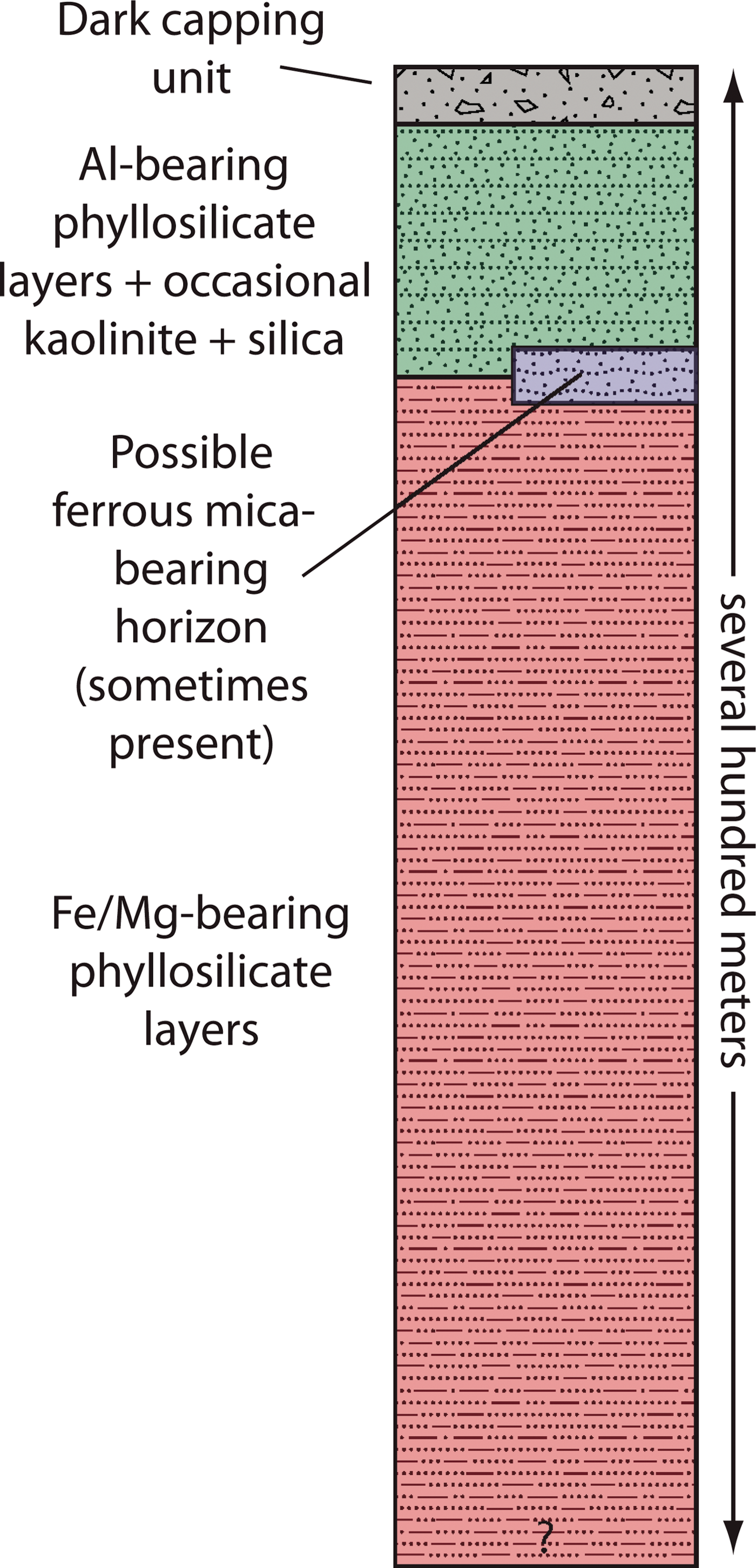
The Mawrth Vallis site consists of exposures of ancient, layered rocks that exhibit near-IR spectral evidence for phyllosilicate minerals (Poulet et al., 2005, 2008a; Loizeau et al., 2007, 2010; Michalski and Noe Dobrea, 2007; Bishop et al., 2008; Wray et al., 2008; McKeown et al., 2009; Noe Dobrea et al., 2010) (Fig. 1). The phyllosilicates fall into two major groups: Fe/Mg-rich clay minerals that are spectrally similar to nontronite, and Al-rich phyllosilicates that are spectrally similar to montmorillonite or, in places, kaolinite, hydrated silica, or both (Figs. 2 and 3). A proposed landing ellipse is situated directly on a large exposure of phyllosilicates (Fig. 3) that occur within layered, fractured bedrock (Fig. 4). The alteration mineral assemblage occurs within a thick (∼150 m) section of layered rocks that are present over ∼600 m of topographic relief throughout the proposed landing ellipse (Fig. 5).
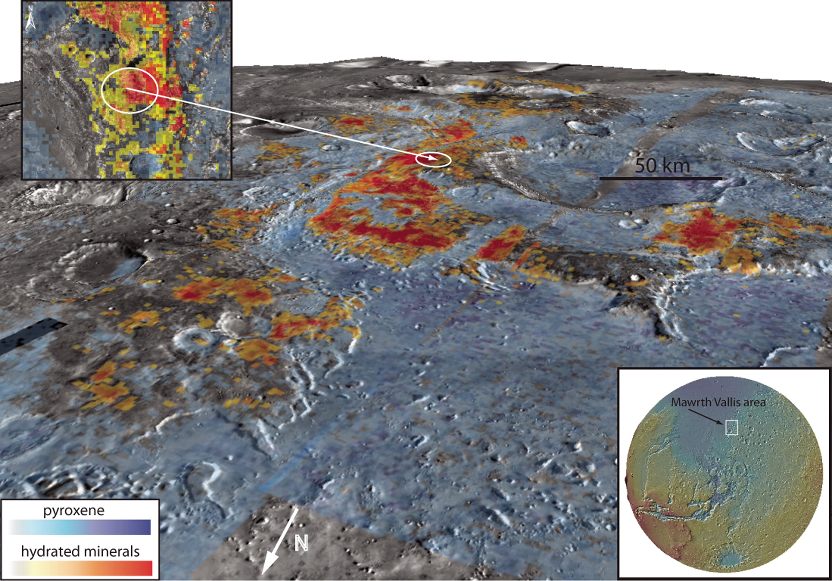
Overview figure with Mars globe and OMEGA data draped over Mars Orbiter Laser Altimeter topography. Two mineralogical indices were derived with use of OMEGA data: a 1.9 μm hydration index, which shows the presence of phyllosilicate minerals in this region, and a pyroxene index (after Poulet et al., 2007). Color images available online at
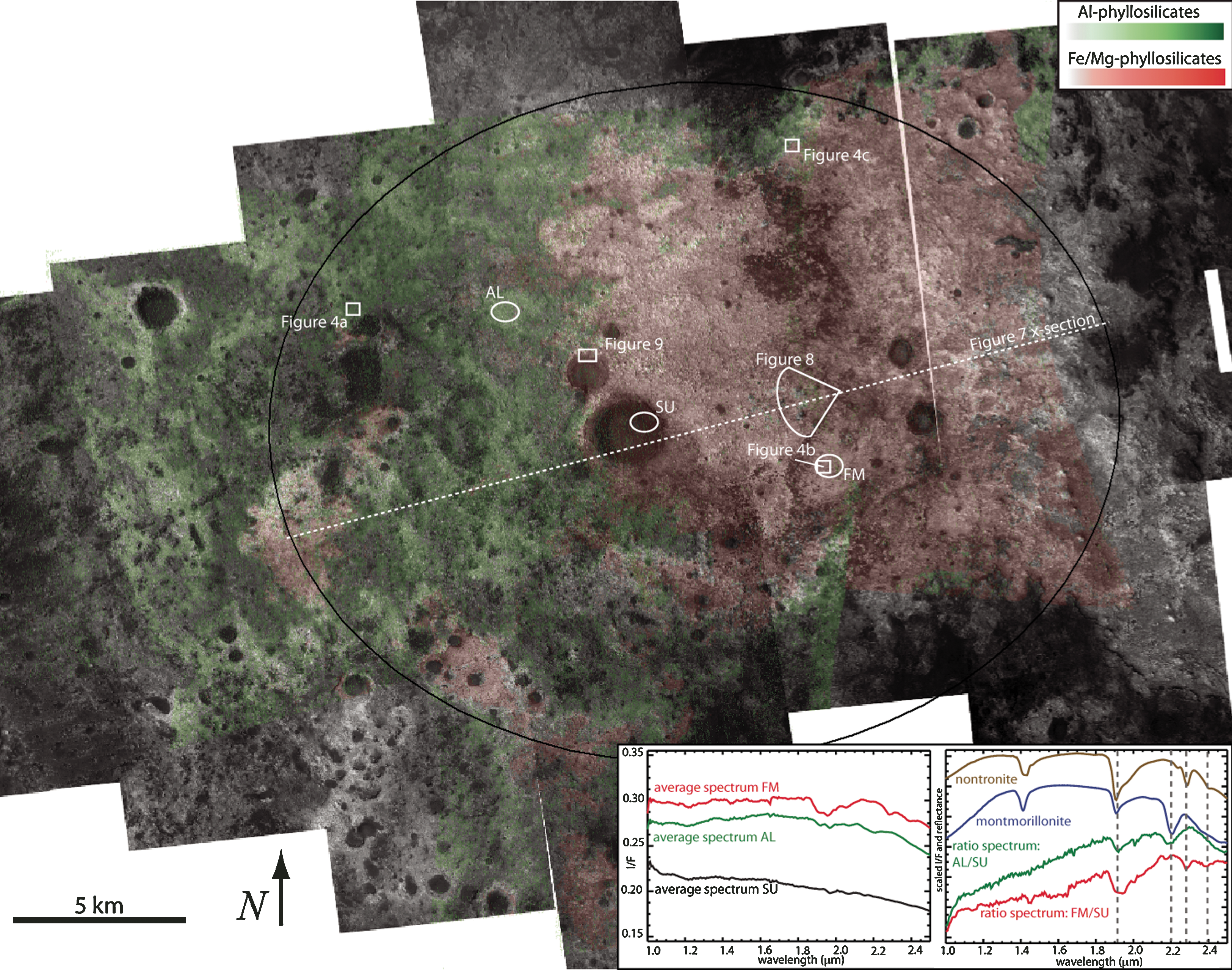
CRISM band parameter maps (2.3 μm in red and 2.2 μm in green) overlain on a HiRISE image mosaic along with example CRISM spectra. The MSL landing ellipse is shown in black. Insets point to the locations of other figures in this paper. HiRISE images include ESP_011884_2045, ESP_012227_2045, ESP_012240_2045, ESP_012517_2045, PSP_005964_2045, PSP_006676_2045, PSP_007612_2045, PSP_008469_2040, PSP_009115_2040, PSP_009326_2040, PSP_010816_2040, and PSP_010882_2040. CRISM images include FRT0000a600, FRT000089f7, FRT0000b141, FRT0000b643, and FRT0000bb59.
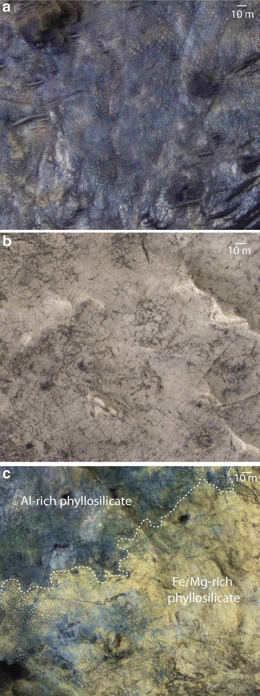
HiRISE images of major terrain units present in the landing ellipse:
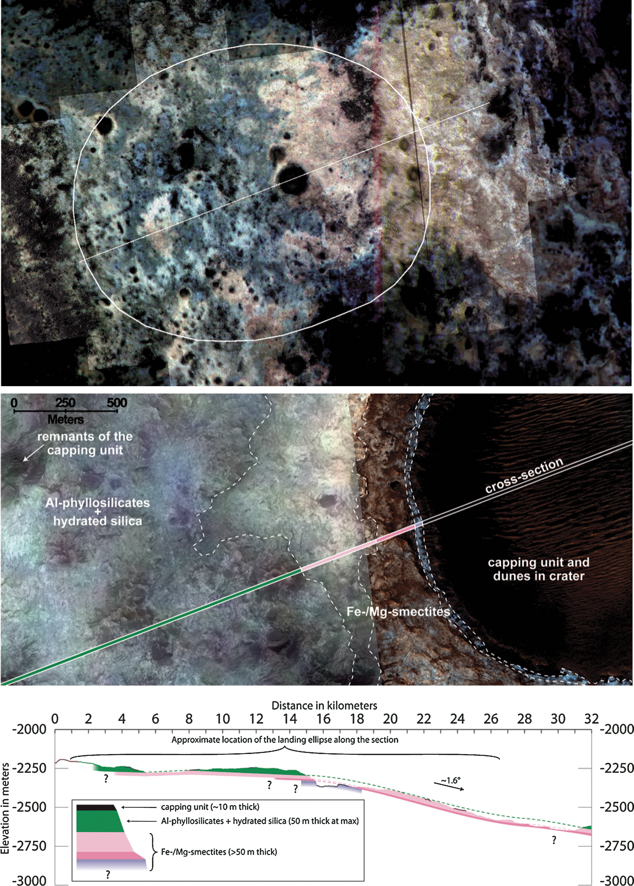
Stratigraphic cross section of the landing ellipse area based on HRSC-derived topography and HRSC color image data (see Loizeau et al., 2010). Color data are shown in plan view at the top, with the full cross-section line shown. Also shown is a small segment near the central crater rim that is enlarged in the middle panel, which shows detailed mineralogical-color-geomorphology relationships. At the bottom, the interpreted cross section is shown to scale.
2. The MSL Mission and Science Objectives
The Mars Science Laboratory is a mobile geoanalytical laboratory that will characterize the geomorphology, petrology, geochemistry, mineralogy, organic chemistry, and atmospheric conditions of a region of Mars. Remote sensing instruments onboard the rover include the Mast Camera (MastCam), a multispectral color imager (Malin et al., 2010), and the Chemistry and Camera (ChemCam), which will determine the bulk and trace element chemistry of targets at a distance of 1.8–9 m with laser-induced breakdown spectroscopy (Wiens et al., 2008). From these remote observations, the topography, stratigraphy, structure, chemistry, and geomorphology of the site will be constructed, and specific geological targets will be selected for further analyses.
The Curiosity rover will carry a suite of instruments for close-up analyses of rocks, soils, and dust at the surface. The Mars Hand Lens Imager (MAHLI) will provide high-resolution (down to 14.5 μm spatial resolution) color imaging to reveal the texture, grain size, and fine-scale bedding character (or fabric) necessary to interpret rock types (Edgett et al., 2009). The Alpha-Particle X-ray Spectrometer (APXS) will be applied to natural rock and regolith surfaces to determine bulk chemistry (Gellert et al., 2009). Samples derived from the surface with a drill, crusher, and sieve system will be analyzed internally by the Chemistry and Mineralogy (CheMin) and Sample Analysis at Mars (SAM) instruments. X-ray diffraction data and X-ray fluorescence data from CheMin will provide structural and chemical information necessary to identify specific minerals and determine bulk sample mineralogy (including the presence of amorphous phases) (Blake et al., 2009). The SAM instrument will survey the organic and light-element chemical content and determine the isotopic geochemistry of samples (Mahaffy et al., 2009).
Four major MSL mission goals have been defined by NASA. These four goals were split and labeled as subgoals in Table 1. To maximize the possibility of successfully detecting chemical, mineralogical, or morphological fingerprints of habitability, as discussed in Table 1, the geological context of a potential landing site must be carefully considered. Sedimentary rocks are clearly the most likely type of material to contain (a) preserved evidence for past life, if it existed, (b) evidence of aqueous surface processes, and (c) evidence of surface-atmosphere interaction (and a record of past climate). In the following section, the geology of the Mawrth Vallis site is discussed in the context of these MSL mission goals.
3. Meeting the MSL Mission Objectives at Mawrth Vallis
The MSL mission goals listed in Table 1 are addressed systematically in this section. Goal IV is not discussed because this objective could be met equally well at essentially all potential landing sites on Mars.
3.1. MSL Goal I: assess the biological potential of the landing site
To assess the biological potential of the landing site region, MSL will use its suite of instruments to inventory C-based compounds, search for the chemical building blocks of life (P, C, N, O, H, and S), and identify features that may record actions of biologically relevant materials. The Mawrth Vallis landing site contains rock types that may have been favorable for the formation of complex organic chemistry and layered rocks that may have high preservation potential.
On Mars, phyllosilicate-rich rocks are ideal targets in which to search for evidence of prebiotic chemistry and evidence of life. The extensive clay deposit at Mawrth Vallis in particular (Loizeau et al., 2007; Bishop et al., 2008) implies a large, stable aqueous system. Fe-bearing phyllosilicates such as nontronite, Fe-rich montmorillonite, and glauconite/illite form preferentially in anoxic waters (Harder, 1988) such as those characteristic of conditions on early Earth (Kasting and Howard, 2006) and possibly early Mars. The changing redox conditions and the mildly acidic environment associated with hydrated silica and kaolinite outcrops (versus the Fe/Mg-smectite-bearing rocks) suggest active chemistry on early Mars (Bishop et al., 2008). Phyllosilicates can catalyze chemical reactions due to their surface acidity and by bringing together molecules on their surfaces (Pinnavaia, 1983). One of them, montmorillonite, has been found to catalyze a number of organic reactions, including the formation of oligomers of ribonucleic acid that contain monomer units from 2 to 30–50 (Nikalje et al., 2000; Ferris, 2006). Theng (1974) reviewed the adsorptive and catalytic interactions of organic molecules on clay surfaces. The particular features of clay chemistry that govern these reactions include the local acidity of clay surfaces, shape specificity of reaction sites, motion restrictions on water molecules, and the binding properties of specific cations (Pinnavaia and Mortland, 1986).
Preservation of biosignatures is favored in rapid burial conditions in fine-grained, clay-rich systems or by chemical precipitation of clay minerals and silica in void space (Farmer and Des Marais, 1999). At present, it is unclear whether the thick (∼150 m) stratigraphic package of layered rocks in this region represents rapid deposition. However, the thick section of rocks implies either an extremely long-lived aqueous system or rapid deposition over a shorter period. On Earth, long-term preservation is most successful in host rocks composed of stable minerals that are resistant to weathering and provide an impermeable barrier for the biosignatures. Mineral precipitates such as phyllosilicates and silica provide an excellent matrix for fossilization of microbial biosignatures (Farmer and Des Marais, 1999). Possible biosignatures include cell-shaped objects, remnants of biomolecules or microorganisms in fluid inclusions, the presence of polycyclic aromatic hydrocarbons, and biogenic mineral structures or compositions (Des Marais and Walter, 1999; Farmer and Des Marais, 1999; Cady et al., 2003; Westall, 2008).
The phyllosilicate-bearing rocks at Mawrth Vallis are ancient. Crater counting suggests that the oldest light-toned, smectite-bearing rocks in this region are Mid- to Late-Noachian (Michalski and Noe Dobrea, 2007). There is debate as to whether the uppermost, Al-bearing phyllosilicate layers in this area were resurfaced (Howard and Moore, 2007; Wray et al., 2008; Loizeau et al., 2010) and chemically weathered by a later stage event (Noe Dobrea et al., 2010). Certainly, it appears in some places that phyllosilicate materials were locally mobilized and redeposited. However, the perseverance of smectite clay minerals in this region for billions of years implies that, subsequent to the minerals' formation, their interaction with water has been extremely limited (in terms of cumulative effects of water/rock ratio, heat, and time) (Tosca and Knoll, 2009). Unlike on Earth, where sediments inevitably become diagenetically altered at the scales of hundreds of millions of years, the lack of diagenetic maturity at Mawrth Vallis implies that the original chemical, mineralogical, and textural properties of the rocks are likely to reflect ancient conditions during the time period in which they formed. This is immensely important in terms of preservation potential; the rocks in the Mawrth Vallis region likely have preserved evidence of surface processes, organic or inorganic, that occurred during the ancient epoch recorded in the rocks.
Compared to other martian phyllosilicate deposits, the Mawrth Vallis rocks offer some advantages in terms of accessibility to preserved material. Some martian phyllosilicate deposits are found within geomorphic settings that are clearly linked to aqueous processes. For example, phyllosilicates within well-preserved delta deposits (Ehlmann et al., 2008; Grant et al., 2008) or putative lacustrine environments (Milliken et al., 2010a) are enticing astrobiological targets. However, these settings may not represent sustained aqueous activity over geologically significant timescales. Furthermore, access to the largest volume of the deposit is limited. In the case of a preserved delta, a surface rover can only access the edges of the deposit. For the Mawrth Vallis area, we have a more complete mineralogical picture of the aqueous history because the terrain is deeply eroded; multiple aqueous mineral assemblages are observed throughout the exposed stratigraphic section. On Earth, paleoenvironments are understood not through studies of preserved paleogeomorphology but through the analysis of good exposures of eroded and tectonically dismembered stratigraphic sections. Because the terrain around Mawrth Vallis is eroded, a surface rover would have access to many exposures that represent environments recorded throughout the volume of the deposit.
3.2. MSL Goal II: characterize the geology of the landing site
One of the critical goals of MSL will be to characterize the geology of the landing site at all relevant spatial scales. MSL will determine the bulk and trace element geochemistry, isotopic geochemistry, mineralogy, and geological context of rocks and soils in order to reconstruct the geological history of the area and interpret the habitability of past environments. One advantage of the Mawrth Vallis landing site is the presence of interesting geological diversity within the landing ellipse (i.e., a long rover traverse is not necessary in order to reach the geological target). Geological characterization of the site could begin on the first sol of science operations. Below, the known geological context of surface materials based on orbital observations is described, and the major questions are framed within science goals of MSL and parameters measurable by the MSL payload.
3.2.1. Background geology and mineralogy
Within the proposed Mawrth Vallis landing site, ancient, phyllosilicate-bearing bedrock, which is light-toned, layered, and intact, is widely exposed (Poulet et al 2005) (Figs. 3 and 4). The light-toned rocks correspond to a thick unit that is layered at the scale of decimeters to meters in most outcrops where observed and can broadly be split into a lower Fe/Mg-phyllosilicate-bearing unit and an overlying Al-phyllosilicate-bearing unit (Wray et al., 2008; Loizeau et al., 2010; Noe Dobrea et al., 2010) (Figs. 2 and 3). This package of phyllosilicate-bearing units is unconformably overlain by a dark-toned, pyroxene and plagioclase-bearing capping unit of unknown origin (Loizeau et al., 2007, 2010; Michalski and Fergason, 2009; Noe Dobrea et al., 2010) (Figs. 2 and 5). Sulfate deposits are also found in the region (Farrand et al., 2009; Wray et al., 2010), though they have not yet been identified within the landing ellipse at Compact Reconnaissance Imaging Spectrometer for Mars (CRISM) spatial resolution (reliable identification requires several pixels at 18 m/pixel).
Although the layered rocks can broadly be split into two compositional subunits, further spectroscopic analyses have revealed a significant amount of compositional variability within the light-toned unit at smaller scales. The lower unit is usually dominated by nontronite (Bishop et al., 2008; Poulet et al., 2008a; McKeown et al., 2009; Noe Dobrea et al., 2010) (Fig. 3) but also contains some evidence for Mg-saponite in certain instances (McKeown et al., 2009). The upper aluminous unit is more variable and shows evidence for montmorillonite and hydrated silica throughout much of the unit, with smaller exposures of kaolinite-bearing material (Bishop et al., 2008; McKeown et al., 2009; Noe Dobrea et al., 2010) and possibly beidellite (Noe Dobrea et al., 2010). In many places, the boundary between these units shows a ferrous spectral slope that may indicate the presence of celadonite or other ferrous mica (Bishop et al., 2008; Noe Dobrea et al., 2010). Bishop et al. (2008) pointed out that this reduced boundary region could indicate a period of rapid deposition or could have resulted from the presence of a reducing agent that facilitated formation of ferrous clay minerals. On Earth, this commonly arises from the presence of biological processes (Brock and Gustafson, 1976; Lowenstam, 1981; Nealson, 1997).
The mineralogy of the rocks at Mawrth Vallis is constrained from multiple perspectives. First, the detection of phyllosilicates is well supported. Multiple Observatoire pour la Minéralogie, l'Eau, les Glaces, et l'Activité (OMEGA) and CRISM spectral detections derived and processed by multiple authors have shown the presence of coherent units bearing correlated absorption features located near 1.4, 1.9, and 2.17–2.32 μm (Poulet et al., 2005; Loizeau et al., 2007; Bishop et al., 2008; Wray et al., 2008; McKeown et al., 2009; Noe Dobrea et al., 2010). Strong evidence for the presence of phyllosilicates lies in (1) multiple diagnostic spectral features that occur together within the same pixels; (2) the overall spectral shape of extracted ratio spectra from these terrain units, which is similar to the spectral shape of phyllosilicates measured in the laboratory; and (3) a strong contribution of phyllosilicates in spectral models of the terrain. Spectral modeling results based on OMEGA data suggest ∼40–50 vol % phyllosilicates present within the layered rocks (Poulet et al., 2008a), mixed with lesser abundances of ferrihydrite, dust, and plagioclase (or another near-IR spectrally “gray” material). Based on these spectral model results and the strength of the absorptions in OMEGA data, the Mawrth Vallis deposits are the most phyllosilicate-rich rocks on Mars. In addition, observations with OMEGA at longer wavelengths have clearly shown evidence for a strong water absorption at 3 μm; these rocks are highly hydrated (6–9 wt % H2O) (Jouglet et al., 2007; Milliken et al., 2007), which is consistent with a significant abundance fraction of hydrated alteration minerals.
Thermal Emission Spectrometer (TES) data provide a different perspective on the mineralogy of the Mawrth Vallis region. TES data clearly show a spectral difference between the phyllosilicate-bearing units and surrounding, relatively unaltered terrains (Michalski and Fergason, 2009; Rogers and Bandfield, 2009). However, there is no definitive evidence for phyllosilicates in the data. Rather, the bulk composition of the altered rocks, derived from TES, is dominated by plagioclase feldspars and silica-rich material (such as aluminous opaline silica) (Michalski and Fergason, 2009; Rogers and Bandfield, 2009). The difference between the two data sets can potentially be explained by a scenario where the alteration assemblage at Mawrth Vallis is dominated by hydrated, poorly crystalline silicates. If the phyllosilicates detected in the near IR are poorly crystalline, they may appear as amorphous in the thermal IR where spectral absorptions of phyllosilicates are dominated by tetrahedral (Si, Al, Fe)-O stretching and bending absorptions (Michalski et al., 2006).
The difference between TES and OMEGA/CRISM results could potentially be explained by other factors. The fact that TES has a larger spatial footprint leads to lower signal contribution from the exposed clay-bearing units to each pixel. Within a single TES pixel (∼50 km2), there are typically several different phyllosilicate-bearing units as well as some dark sand; mixing of the various spectral characteristics of each results in an average composition for the layered rocks. More likely, surface roughness that leads to multiple scattering and, hence, strong detections in the near IR has an inverse effect in the thermal IR (Mustard and Cooper, 2005). Those units with the strongest phyllosilicate features in the near IR may be poor emitters in the thermal IR.
3.2.2. Hypotheses for the origin of layered rocks at Mawrth Vallis
Strong constraints have been placed on the origin of the Mawrth Vallis deposits, but many interesting questions remain. What was the source of the water that altered these rocks? Were the rocks altered at the surface, in the shallow subsurface, or in both settings? What were the sources of clastic materials contained within the rocks? Through which mechanisms, or combination of mechanisms, were the clay minerals deposited: chemical precipitation, mineral replacements, glass replacements, or vein fill? For all martian phyllosilicate deposits, these questions would have to be answered from in situ studies. Still, much is known about the potential origins of altered deposits in the Mawrth Vallis area.
Any interpretation of the geological history of this region must take into account the following important facts: The phyllosilicates are clearly tied to the ancient, layered rock units, and are not a diffuse weathering pattern that could have resulted from recent surface action. The layered rocks are intensely altered and, with the use of CRISM or OMEGA data, were found to contain no evidence of pyroxene; almost everywhere, however, the layered rocks were found to contain evidence for hydrated minerals. The rocks are layered essentially everywhere they have been observed; and, within this layered section, they contain evidence for buried impact craters and folding or channeling (i.e., evidence for unconformities within the stratigraphic package). Therefore, these rocks were deposited over a duration of time rather than in a single catastrophic event (Michalski and Noe Dobrea, 2007). The compositional stratigraphy is almost exclusively aluminous clay minerals over ferromagnesian clay minerals (Wray et al., 2008; Loizeau et al., 2010), and this compositional stratigraphy is present throughout a large region around Mawrth Vallis (>106 km2) (Noe Dobrea et al., 2010). Therefore, the process that led to their formation must have operated on a large scale. The rocks are intact and relatively flat-lying. Although they have been buried to some depth and later exhumed (Michalski and Noe Dobrea, 2007), they have not been buried very deeply, nor have they been severely deformed by regional stresses.
Based on the observations, several hypotheses for the origin of the phyllosilicate-bearing units can be eliminated. If the spectral features of clay minerals resulted only from surface coatings and recent weathering phenomena, we would expect to see a diffuse spatial distribution of alteration minerals that was more closely tied to the present geomorphology and exposure age than to lithologic units, and we would not expect to see compositional stratigraphy throughout such a large area. While it is possible that all surfaces in this region have experienced some effects from recent chemical weathering, this process alone cannot explain the origin of the phyllosilicate-bearing rocks. Regional metamorphism can also be ruled out not only because the pressure gradient is low on Mars and it is difficult to reach metamorphic conditions in the shallow crust but also because the rocks are not deformed as would be expected if they had been buried deeply and later exhumed. Also, the alteration mineral assemblage is not consistent with the expected low-grade alteration assemblage in a basaltic protolith: chlorite-, serpentine-, carbonate-, and zeolite-group minerals.
Impact origin can be ruled out as the sole emplacement mechanism. Indeed, the Mawrth Vallis deposit may be a unique window into an ancient epoch of the Solar System, when impact was the dominant geological process. During the Late Heavy Bombardment, impact may have generated a significant amount of fragmented material, delivered a large quantity of water to the planet as icy impactors, and caused warmer climate excursions (Bibring et al., 2006). In this way, impact could be linked to phyllosilicate formation in a general sense. However, if the package of rocks formed from a single impact event, it would be unlikely that fine layering at decimeter to meter scales would be observed throughout a ∼150 m thick stratigraphic section of rocks over such a large area. It is true that the proposed landing ellipse is located directly adjacent to Oyama Crater, which is a large (108 km diameter) impact crater. Based on proximity alone, it is possible that the rocks within the ellipse could have been located on ejecta from that crater. However, there is little morphological evidence for ejecta from Oyama Crater in the landing ellipse or elsewhere. Other evidence that suggests the region has experienced hundreds of meters of erosion may also explain why there is little evidence for ejecta from Oyama; it was likely eroded away. Furthermore, there is evidence that the rocks throughout this region were deposited over a duration of time, so a single event or even several large impact events cannot explain the origin of the whole section of rocks. Impacts probably contributed to the clastic budget and contributed to the climate scenario in which the rocks formed, but the deposit is probably not an impactite.
If the alteration occurred due to some localized hydrothermal phenomenon (e.g., associated with an igneous intrusion or impact structure), we would expect to see alteration products tied to fluid conduits, such as faults and fractures, and we would not expect to see such a widespread and consistent distribution of alteration minerals through a large area within flat-lying units. While inverted ridges interpreted as large mineralized fractures are observed within the layered rocks (Michalski and Noe Dobrea, 2007; Wray et al., 2008), phyllosilicate-bearing surfaces are not localized around these features. Therefore, a strictly hydrothermal interpretation for the origin of the mass of altered, layered rocks can be eliminated (though the occurrence of a late-stage hydrothermal or diagenetic event associated with the veins is likely).
Several other formation hypotheses remain and are discussed below (Table 2). A likely scenario is that the rocks are either sedimentary or pyroclastic in origin (although it is highly probable that impacts would have contributed to the clastic budget in any case). In the pyroclastic scenario, the rocks would have been deposited through a series of eruptions, and the alteration mineralogy would have occurred due to either deposition of the ash into surface waters or diagenetic alteration of the rocks in the subsurface after deposition. The compositional boundary between the aluminous and ferromagnesian subunits observed today would correspond to either an original boundary between pyroclastics of different starting composition (e.g., felsic ash overlying mafic ash) or a change in aqueous geochemical conditions (e.g., the past location of the water table or progressive leaching of the uppermost rocks versus alteration in a saturated environment in the lower unit) (e.g., Noe Dobrea et al., 2010).
The sedimentary scenario is not entirely separable or different from the pyroclastic scenario. Here, the clasts that make up the sedimentary rocks could be any, or all, of the following: basaltic composition silt and sand derived from volcanic sources, pyroclastic material reworked by sedimentary processes, dust deposited by climatic forcing, or impact-derived clasts. The clay minerals within the layered rocks may have been delivered to the environment as clastic load from a distal source, along with other siliclastic materials (Fig. 6). Alternatively, they may exist as cement, veins, mineral or mesostatic replacements that formed during diagenesis, or direct precipitates from surface water. The diagenetic scenario here is similar to that described above in the pyroclastic case. However, an additional possibility exists: the boundary between the upper aluminous unit and the lower ferromagnesian unit may represent a horizontal boundary in environmental conditions (Walther's Law). A migrating environmental boundary in time could explain the vertical compositional boundary observed today. Such a boundary could have been between a perennially wet environment and a subaerially exposed environment.

Phyllosilicates may occur in a number of textural contexts within the rocks at Mawrth Vallis. In situ investigations are required to understand whether the clay minerals occur as cements, mineral or glass replacements, veins, or clasts from a distal source. Color images available online at
A pedogenic model is also possible, but this is not a fundamental shift from the sedimentary or volcanic models because it is compatible with both of these scenarios. Here, the clasts that make up the layered rocks are either sedimentary or pyroclastic, and the compositional stratigraphy is explained by reworking of the uppermost section of the rocks during surface exposure. Ancient chemical weathering of the ferruginous clay unit is invoked to explain the formation of the aluminous unit. This is somewhat similar to the diagenetic alteration scenario; but, in the pedogenic model, the uppermost aluminous layers may have been exposed subaerially and physically reworked. An important implication of this model is that the aluminous layers are unconformably overlying, and may be younger than, the ferromagnesian clays in the lower subunits. This model may explain why the ferromagnesian layers are apparently flat-lying and clearly exposed within crater walls, yet the aluminous layers in places give the impression of draping topography (Howard and Moore, 2007; Wray et al., 2008; Loizeau et al., 2010; Noe Dobrea et al., 2010). Furthermore, in the bigger picture, geomorphic evidence of inverted channels and craters points to a period of denudation of the terrain, which may have been caused by eolian erosian, fluvial erosion, or both. The pedogenic model fits well with this concept; the ferromagnesian subunits may have been exposed and altered further during the same denudation event that eroded the terrain at a regional scale. During the late stages of that event, a residue of altered regolith may have remained, draping the older ferromagnesian subunit (and always on top of it).
The three hypotheses for the origin of phyllosilicate-bearing rocks in the Mawrth Vallis area discussed here are not mutually exclusive. On ancient Mars, volcanism and impact would have been more dominant processes than in recent history (Greeley and Spudis, 1981; Hartmann and Neukum, 2001), and any rocks recording this period of time would likely contain volcanic and impact-derived materials. A >150 m thick layered, complex section of rocks likely represents a range of environments and processes.
While orbital studies carried out to date have strongly constrained the origins of these deposits, interesting scientific questions and specific, evolved, testable hypotheses remain. All the possible scenarios that may have occurred in this region involve a significant amount of water and a stable, though variable, aqueous system. The section of rocks likely recorded a number of different aqueous settings, all of which are exciting from the perspective of habitability potential. Examples of volcanic or impact glass and mafic minerals altered in stable surface environments and protected, subsurface environments, along with localized diagenetic-hydrothermal phenomena (associated with large cross-cutting mineralized veins), are probably all present within the stratigraphic section. There exist a range of enticing geological environments to explore with MSL. The deposit probably dates to the Late Heavy Bombardment (Mid- to Late-Noachian), a period that has not been extensively explored on Mars or Earth.
3.2.3. Implications of various geological models for preservation potential
The preservation potential of organic materials within the deposit at Mawrth Vallis would be different for the various proposed geological scenarios. Preservation potential of organic material is increased by (a) processes that concentrate organics in sedimentary depocenters; (b) rapid burial, which protects the organics from various destructive processes; and (c) association with high specific surface area sedimentary minerals. Both silica and phyllosilicates are alteration minerals with high specific surface areas that are widespread in the Mawrth Vallis area, which, in all the proposed geological models, could favor preservation of organic materials. The pyroclastic model is probably the least favorable for preservation of organic materials, unless the volcanogenic materials were deposited into an aqueous sedimentary environment. The pedogenic model is potentially unfavorable for preservation of organic matter, particularly within the veneer of clay and silica-rich surface materials that were extensively physically processed and oxidized during a second phase of surface erosion and weathering. In general, a sedimentary model is favorable with regard to preservation potential, especially because the deposit contains abundant clays, and the diverse stratigraphic section likely captures a range of depositional environments. Aspects of the geology are consistent with lacustrine or marine settings, which may be favorable for preservation, particularly if the deposition rate was high as has been suggested from the presence of chemically reduced horizons within the section (Bishop et al 2008). If clay minerals were delivered to the depositional setting as clastic material from a distal source, then the sedimentary processes that delivered the material may have also served to concentrate organics derived from a large source region. If the alteration minerals formed in situ, then organic materials may have become trapped by precipitation of chemical cements during diagenesis. In summary, the preservation potential of organics within the Mawrth Vallis deposit is somewhat difficult to characterize because the deposit is extremely ancient, diverse, and extensive; it does not contain obvious, preserved geomorphology of a single aqueous setting (e.g., a lacustrine delta). However, the likely sedimentary nature of the materials and the abundant clay mineralogy are favorable for preservation of organic materials. Furthermore, regardless of what is preserved at this site, it is probably representative of a large-scale environment and global-scale processes at the time when the rocks formed.
3.2.4. Understanding the geology at Mawrth Vallis with MSL
In situ analyses, specifically of the rock textures, bedding styles, trace and bulk rock geochemistry, geological contacts, and the trace and bulk rock mineralogy, would provide critical new insights into the geology of the Mawrth Vallis area and reveal details necessary to differentiate between various hypotheses for their origin(s). Table 2 summarizes some of the most basic, testable aspects of the various hypotheses for the origin of Mawrth Vallis rocks. It will be possible to meet MSL mission Goal II through systematic tests of the local geology within the capability of the MSL scientific payload.
From orbit, it is not possible to determine exactly which type of rocks the clay minerals reside within. From the surface, MSL will use high-resolution color images to evaluate the grain size, grain size distribution, and grain shapes (angular or rounded, crystalline or clastic) (Fig. 6). Pyroclastic rocks should contain evidence for angular shards of glass, with a limited grain size distribution. In the case of clastic rocks, the grain size distribution and grain roundness—in addition to possible sedimentary structures—will provide evidence for the energy of the geological environment in which the sediments were deposited (e.g., low-energy lacustrine or high-energy fluvial). Additional textures in the rocks such as crystal molds, vugs, veins, or soft sediment folds will provide insight into conditions of early diagenesis, synsedimentary deformation, or both (e.g., Grotzinger et al., 2006). Color imaging of the rocks, single spot analyses of elemental rock chemistry with ChemCam, and careful selection of individual samples for processing by the CheMin instrument will constrain how the phyllosilicates exist within the rocks: whether the clay minerals occur as clasts, cements, veins, vug fill (amygdules), or glass replacements (Fig. 6). These measurements are central to evaluating the origin of individual beds and reconstructing the history of the whole stratigraphic package.
A second major task will be to evaluate the nature of geological contacts within the section. This will be accomplished by imaging the physical boundary of the rock units and carrying out chemical and mineralogical measurements across physical bedding contacts. Two major possibilities exist: composition may be closely tied to bedding, or composition may vary independently of bedding. Two sample-stratigraphic sections are shown in Fig. 7, based on actual topography of the landing ellipse and the actual exposure of the various phyllosilicate units. The depth dimension is conceptual to illustrate two possibilities. If the various phyllosilicate units have compositions that largely follow bedding planes, we can conclude that either (1) the various rocks were deposited in different environments that varied in space or time, or both; or (2) the diagenetic model may be correct, but different starting compositions or permeability inherent to individual rock units caused these rocks to respond differently to diagenetic conditions. If the compositions crosscut various physical bedding contacts, it will suggest that the diagenetic models and pedogenic models are more likely correct.
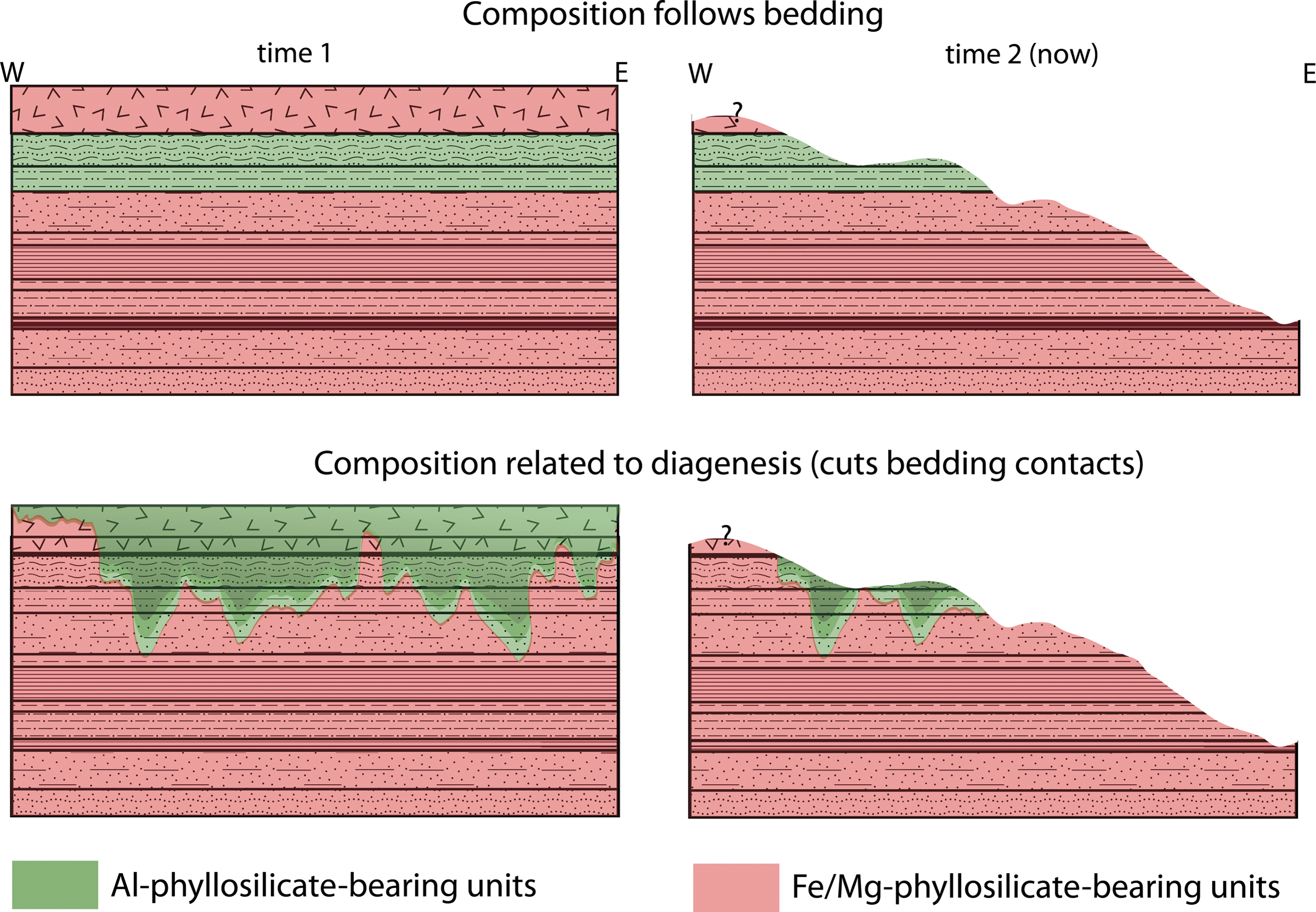
A schematic cross section that illustrates two end-member scenarios to explain the geological contacts present between the compositional units within the landing ellipse. Scenario 1 suggests depositional contacts where composition follows physical stratigraphy. Scenario 2 suggests that composition cuts physical stratigraphy, and probably formed from a combination of diagenetic and pedogenic processes. We do not mean to imply that the strata in this region are perfectly flat lying; this is an example to illustrate possible contact relations. Color images available online at
Access to stratigraphy is critical to the mission success. The Opportunity Rover at Meridiani Planum has achieved this through observations of strata exposed in crater walls; but at Meridiani Planum exposures are limited, and the operations within craters are somewhat treacherous. In the few cases where impact craters are found within the layered rocks at Mawrth Vallis, the same tactic could be applied. But at Mawrth Vallis this will not be necessary because the strata are well exposed throughout the landing site region, over hundreds of meters of subtle relief across the landing ellipse (Fig. 8). In Fig. 8, the actual size of the rover is shown, illustrating the typical working environment in normal, flat terrain, and the accessible stratigraphic section of rocks available through shallow topographic relief. Although relatively flat and easy to traverse, the landing ellipse contains hundreds of meters of relief across which hundreds or thousands of individual layers are likely exposed and accessible. No matter where the rover lands within the landing ellipse, science operations could commence immediately, which would allow for a long traverse through a complex section of layered rocks.
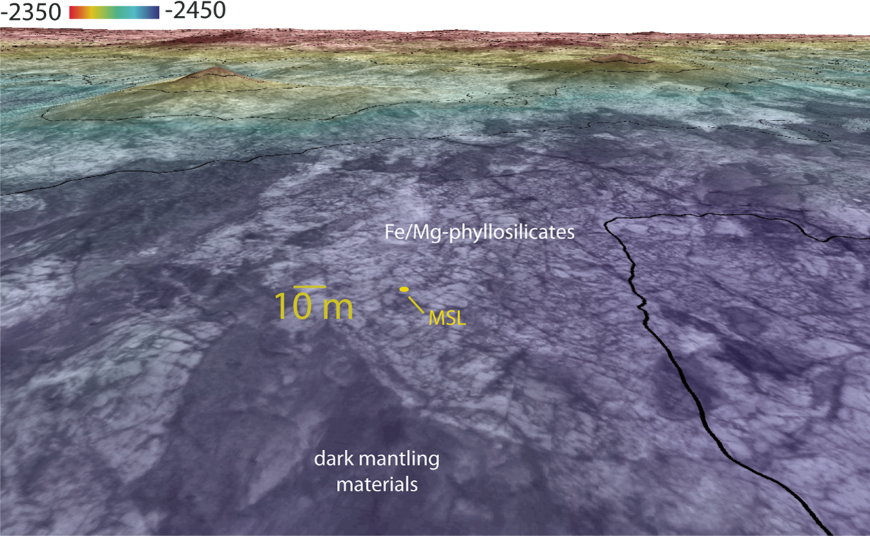
A HiRISE image and colorized elevation derived from HiRISE data were draped over a HiRISE Digital Elevation Model. Distance from the foreground to the horizon is approximately 2 km. The approximate size of the rover is shown in the foreground.
Some specific questions pertaining to habitability can only be addressed from the surface. If the altered rocks in this region represent a long-lived, stable aqueous system, we would expect that the alteration assemblage be dominated by crystalline phases. Spectral data show that phyllosilicates, which are by definition crystalline, are present. But what fraction of the alteration assemblage do these minerals compose? Do they occur within abundant amorphous phases, such as palagonitic glass? In the aluminous unit, are smectites overprinted by a later stage of alteration in which silica was deposited as veins, or are the aluminous phyllosilicates and silica intimately mixed? The CheMin instrument will determine what fraction of amorphous and crystalline phases are present in the rocks (Blake et al., 2009). Also, for the clay minerals that are present, CheMin will determine how ordered the structures are and their degree of expandability by measuring the change in X-ray properties at multiple times as the samples dehydrate after delivery into the instrument.
3.3. MSL Goal III: investigate planetary processes relevant to past habitability
A third goal of MSL will be to connect the observations within the landing site area to a bigger picture, to planetary-scale processes relevant to past habitability. The mission will determine the role of water in the landing site region and beyond, the long timescale atmospheric evolution, and the present state and cycling of water and CO2. To do so, it is necessary to choose a landing site with rocks that are (a) representative of surface processes and surface-atmosphere interactions, (b) clearly representative of the presence of water, and (c) understandable within the regional stratigraphy and larger-scale geological context at Mars.
The altered rocks at Mawrth Vallis are clearly representative of past aqueous activity, as discussed above, and formed in a surface or near-surface environment. The complex layering and presence of unconformable contacts within the stratigraphic section point toward surface processes (Michalski and Noe Dobrea, 2007). The presence of smectite clay and amorphous silica rather than interlayered clays (Milliken et al., 2010b) indicates that the phyllosilicates did not form at great depth and have not experienced significant diagenetic alteration subsequent to their formation (Tosca and Knoll, 2009; Milliken et al., 2010b). The geomorphology of the region suggests that the deposits were buried in the shallow subsurface and later exhumed, based on the presence of an eroded capping unit and a reset small-crater population (Michalski and Noe Dobrea, 2007). All these pieces of evidence indicate that the phyllosilicates and the rocks that contain them formed at or near the surface of Mars and, therefore, are likely to contain evidence for surface aqueous processes and surface-atmosphere interaction.
While many of the altered deposits discovered to date on Mars occur within small, isolated geological environments throughout the ancient crust (Carter et al., 2009; Murchie et al., 2009; Poulet et al., 2007), the Mawrth Vallis deposits are different. The phyllosilicate-bearing rocks within the landing site are part of a vast and contiguous deposit (Poulet et al., 2005; Noe Dobrea et al., 2010). Further analysis with CRISM data has shown that the same mineralogical stratigraphy occurs within morphologically similar deposits throughout a much larger area in the western Arabia Terra region (Noe Dobrea et al., 2010). The processes that led to the formation of altered rocks at Mawrth Vallis must necessarily have been large-scale processes, and relevant to the question of planetary-scale habitability.
4. MSL Mission Operations at Mawrth Vallis
4.1. Operations scenarios
A short description of likely mission operations scenarios is warranted here because mission operations considerations are relevant to the landing site selection process; the science that can realistically be achieved at a given site is a function of the operations realities and the physiographic properties of the site. During the 669 sol primary mission, communications and energy must be budgeted between various necessary mission activities. Basic rover operations such as system checkouts, software updates, and solar conjunction scenarios are expected to use ∼40 sols of mission time. An additional ∼110 sols will be unavailable for commanded operations due to Earth-Mars phasing. Full sample analyses are expected to use ∼5–8 sols per sample target. Drive speed is estimated at 50–100 m/sol; it will require approximately 100–200 sols of focused drive time to traverse 10 km of the landing site region. The mission goal is to analyze 28–75 sam-ples, which will utilize 140–600 sols (see
4.2. The landing ellipse: immediate science results
The proposed Mawrth Vallis landing ellipse is shown in Figs. 1 and 3. The landing ellipse is centered on the area with the strongest hydration signal in the region from OMEGA spectral data. Within the landing ellipse, the three major terrain units of this region are found: (1) an Fe/Mg-phyllosilicate-bearing, light-toned, layered unit; (2) an Al-phyllosilicate-bearing, light-toned, layered unit; and (3) a dark-toned, spectrally unremarkable unit (Fig. 3). High Resolution Imaging Science Experiment (HiRISE) images of the phyllosilicate-bearing terrain units and the contact between them are shown in Fig. 4. The aluminous unit is bluer than the ferromagnesian unit (as noted by Wray et al., 2008 and Loizeau et al., 2010) and commonly contains fields of polygonally fractured terrain. The ferromagnesian unit is redder in visible light than the other unit and is, overall, smoother and intensely layered. Plan-view images show only subtle clues of bedding in some cases. However, where impact craters are found within the phyllosilicate units, the walls of the craters show the three-dimensional structure of the units in detail (Fig. 9). Here, a large number of layers are observed down to the resolution of the images, and the presence of dikes or (more likely) mineralized veins are observed, crosscutting bedding and protruding from crater walls as relatively resistant surfaces.
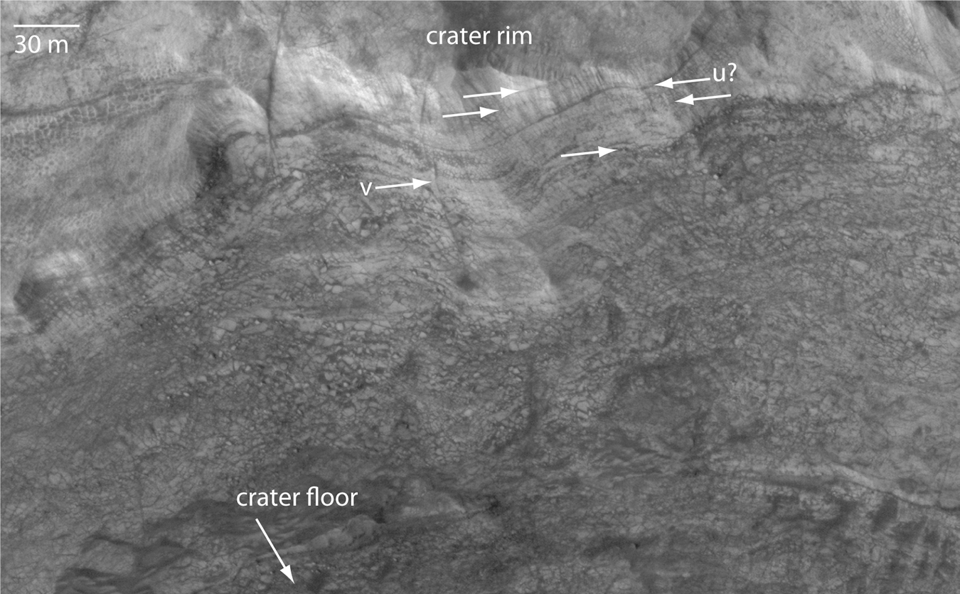
A HiRISE image that shows layering present within one of the rare craters that formed within the phyllosilicate-bearing units within the ellipse. u, unconformity; v, veins.
The key points about the Mawrth Vallis landing site are (1) the ellipse is centered directly on aqueously altered, layered rocks with immense possibilities to explore a complex geological record; (2) the ellipse contains two important geological contacts—the contact between the aluminous phyllosilicate layers and the ferromagnesian layers, and the contact between the phyllosilicate-bearing units and the overlying dark-toned unit; and (3) the ellipse is relatively flat yet contains significant exposures of layers that can be traversed systematically in order to reconstruct a large section of geological time.
4.3. Long-term scientific planning
As discussed above, the primary science objectives of MSL can be met through the analysis of a thick stratigraphic section of mineralogically diverse, ancient, layered rocks. These materials are the primary science target. However, there are a number of other observations that can be made in the region, which are highly relevant to the major mission goals listed in Table 1. These are particularly relevant to understanding planetary processes relevant to habitability. A regional view of the landing site area and distances to various targets of interest is shown in Fig. 10.
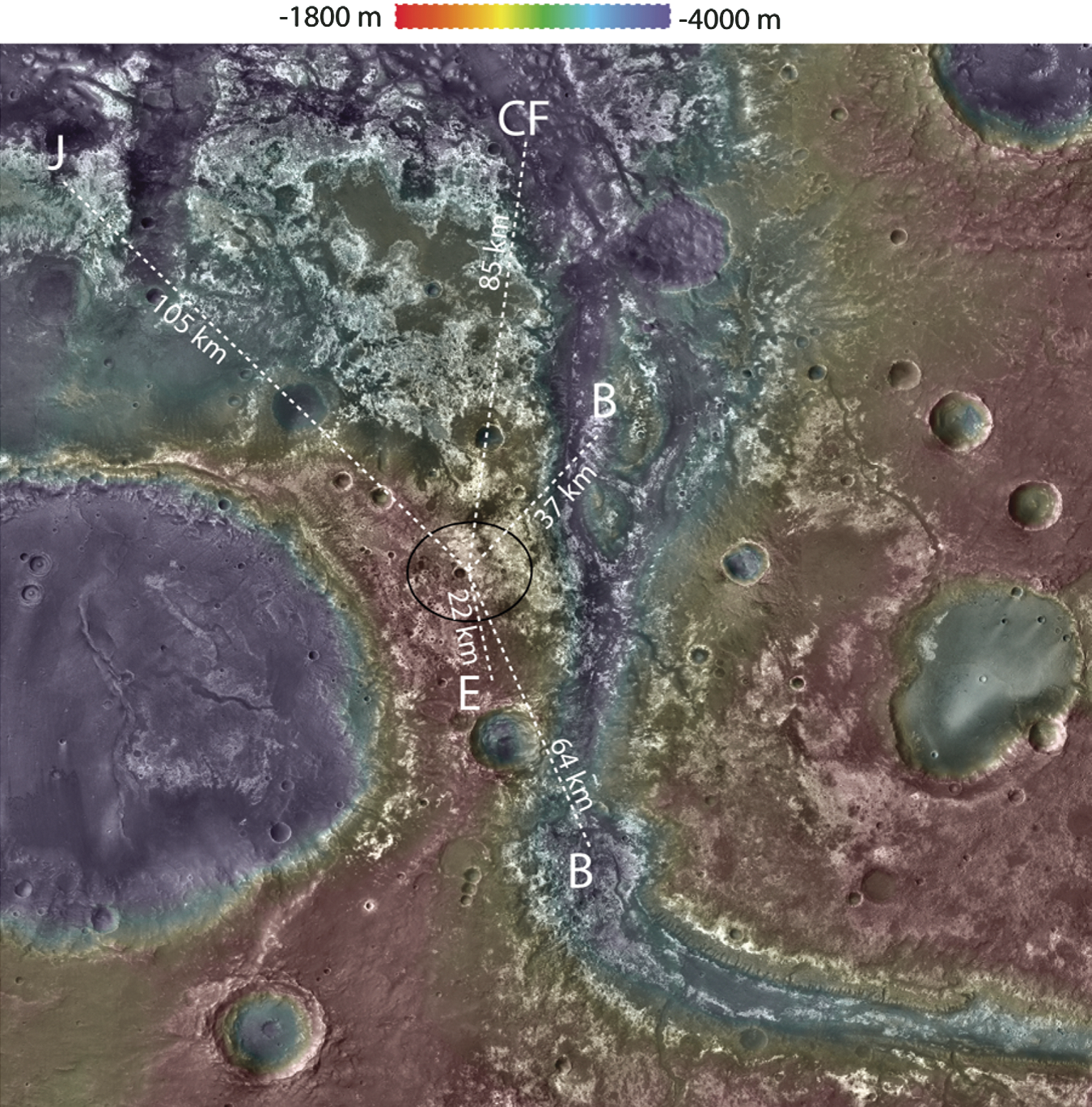
Mars Orbiter Laser Altimeter data are overlaid on an HRSC image mosaic, showing the targeted landing ellipse and a number of deposits of interest for long-term mission planning. “B” corresponds to bassanite occurrences reported by Wray et al. (2010); “J” corresponds to jarosite deposits (Farrand et al., 2009); “E” corresponds to crater ejecta discussed in the text; and “CF” corresponds to channel fill deposits discussed in the text.
4.3.1. Dark materials
Stratigraphically above the layered, light-toned rocks is a dark capping unit likely of Hesperian age (Loizeau et al 2007; Michalski and Noe Dobrea, 2007) (Fig. 10). The origin of the unit is unknown, but it may be a dark sedimentary deposit composed of mafic sand, a large-scale pyroclastic deposit, or an impactite deposit (Noe Dobrea et al., 2010). In the near IR, it contains evidence for pyroxene (Loizeau et al., 2007; Noe Dobrea et al., 2010). Thermal IR data suggest the deposit is largely basaltic with a component of poorly crystalline materials (glass or weathering products) (Michalski and Fergason, 2009). Locally, it has eroded into talus and loose surface materials that probably have fed local sand dunes. The origin of this mafic material is unknown and could be linked to other pyroxene-bearing surface materials observed elsewhere on the planet. Therefore, this provides an interesting target for understanding regional- to global-scale sedimentary and igneous processes (McSween et al., 2009). Characterization of weathering products within the capping unit and the dunes derived from it would also provide an important part of the global aqueous story on Mars since the Hesperian.
4.3.2. Sulfates
Several detections of sulfate in the Mawrth Vallis region have been reported, although there are no known exposures within the landing ellipse to date (Fig. 10). Layered, jarosite-bearing deposits are found approximately 105 km northwest of the ellipse (Farrand et al 2009). East of the landing site, several deposits of bassanite-like sulfates are found within the Mawrth Vallis channel (Wray et al., 2010). While the jarosite deposits are too distant to visit within a realistic mission timeline, the bassanite deposits located ∼37 km from the center of the landing ellipse could potentially be visited by MSL, while enabling a long traverse through a well-exposed stratigraphic section in the Mawrth Vallis channel wall en route. Even more intriguing is the possibility that increased CRISM data coverage will continue to reveal new deposits of sulfates even closer to the ellipse or within it.
Understanding the mineralogy of the sulfate-bearing deposits at Mawrth Vallis would provide a connection to the significant results returned from Meridiani Planum by the Opportunity rover (Squyres et al., 2006, 2009). Geological contact relationships between the phyllosilicates and the sulfates at Mawrth Vallis could help explain the nature of contact relations between sulfates and phyllosilicates in the greater Meridiani Planum area (Poulet et al., 2008b; Wiseman et al., 2008). The environmental conditions implied by the presence of sulfates are quite different from those implied by the widespread occurrence of smectites in this region. Investigation of sulfate deposits at Mawrth Vallis by MSL would provide a window into a later era of aqueous history on Mars (Bibring et al., 2006) and provide a fundamentally different target in which evidence of life could have been preserved.
4.3.3. Mawrth Vallis channel fill
A long traverse eastward from the landing ellipse would take MSL down-stratigraphic section (Fig. 10), through a thick exposure of phyllosilicate-bearing rocks along the bank of the Mawrth Vallis outflow channel (Loizeau et al 2010), such that it would ultimately arrive at the floor of the channel. From this position, MSL could investigate the origin of channel fill deposits exposed on the channel floor. Understanding the texture, composition, and, ultimately, provenance of channel materials is critical to understanding how outflow channels have operated on Mars. Despite their place among some of the earliest features to have been discovered on Mars, their relationship to global climate and the evolution of surface volatiles on Mars remains a mystery.
4.3.4. Impact ejecta
What is the nature of the oldest martian crust? Is the crust deeply altered in this region, or are the layered phyllosilicates resting on ancient, igneous bedrock? Analyses of impact-exhumed materials would provide an opportunity to explore the lower stratigraphic units of the phyllosilicate deposits or possibly the geology of basement rocks upon which they rest. Approximately 22 km to the south of the center of the ellipse, the occurrence of phyllosilicate-bearing lobate ejecta would enable the study of deeper rocks (Fig. 10). The ejecta correspond to a 16 km diameter crater, the ejecta of which was seemingly excavated from >1 km depth (Loizeau et al 2010). Studies of the impact ejecta and of the crater itself would provide a new suite of materials and new cross section of the crust in this region.
4.3.5. The big picture
Finally, we believe that the Mawrth Vallis region has a fundamental astrobiological interest beyond just Mars' history. In recent years, important evidence about climatic conditions on primitive Earth has been obtained. Plate tectonics has erased most of Earth's geological record older than 3.8 Ga; few clues remain concerning the original conditions on primitive Earth in the 4.5–4.0 Ga time period. However, zircon study results indicate that liquid water was present on Earth 4.3 billion years ago (Watson and Harrison, 2005) and that continents had already formed between 4.4 and 4.3 Ga (Mojzsis et al 2001; Wilde et al., 2001; Harrison et al., 2005). Earth and Mars may have had habitable environments 4.3–4.5 billion years ago. What were the environmental conditions like during this early period in the Solar System? What role did meteor bombardment play in the evolution of the crust and climate at that time? The Mawrth Vallis phyllosilicate-rich deposits, which are unique in the Solar System, could have preserved the evidence of climatic conditions that prevailed before 4.0 Ga. There is no doubt that a detailed investigation of these deposits would reveal new insights into fundamental geological processes operating in the early Solar System.
5. Summary and Conclusions
If life ever arose on Mars, it likely occurred early in the planet's history in association with stable aqueous environments. We propose that the upcoming MSL mission, which will search for evidence of habitability and past life on Mars, should land in the most phyllosilicate-rich region of Mars: the Mawrth Vallis region. Ancient martian phyllosilicate deposits are high-priority astrobiological targets for the following reasons: (a) they are strong indicators of ancient aqueous processes, (b) clay mineral–rich sediments are thought to have been catalysts for the formation of complex prebiotic chemistry on Earth and could have played a similar role on Mars, (c) the preservation potential of organic matter is high within sedimentary phyllosilicate deposits.
The Mawrth Vallis region contains a thick stratigraphic section of diverse, ancient, complex rocks, likely of sedimentary origin. The alteration mineral assemblage includes a variety of clay minerals as well as sulfates and hydrated silica, and therefore represents a range of aqueous geochemical environments to explore. Dating to the Mid- to Late Noachian, the Mawrth Vallis deposit provides a window into an era that has not yet been explored in situ on Mars. The persistence of smectite clays in these deposits for billions of years indicates that the deposits have remained largely unmodified by subsequent diagenetic processes since their deposition (Tosca and Knoll, 2009).
The geological context of the rocks at Mawrth Vallis provides a well-defined framework in which to carry out exploration of the surface with MSL. The stratigraphic section is thick and complex yet understandable within the capability of the MSL scientific payload. Regional stratigraphic correlations place the Mawrth Vallis deposits within a larger context, which will enable connection between MSL results in the landing site area and global-scale processes of relevance to planetary habitability.
Many of the possible formation processes for the rocks at Mawrth Vallis have been discussed here. However, as is always the case, our understanding of martian geology is limited by both terrestrial experience and imagination. The Meridiani Planum landing site was chosen for the Opportunity rover based largely on the detection of unique mineralogical signatures (gray hematite) (Christensen et al., 2001). Upon landing, in situ investigation by the Opportunity rover showed that the actual origin of hematite detected from orbit was completely different from hypothetical origins proposed prior to landing (Glotch et al., 2006). Even so, exploration of Meridiani Planum from the surface in many ways revolutionized our understanding of aqueous processes on Mars. One of the key messages from that mission was that unusual alteration mineralogy detected from orbit led us to incredible deposits that are unique in the Solar System. The same lesson will apply to Mawrth Vallis, where the alteration mineralogy detected from orbit may not yet be fully understood. However, it is certain that in situ exploration of these deposits will lead to new understanding of aqueous processes on and habitability of Mars.
Footnotes
Abbreviations
APXS, Alpha-Particle X-ray Spectrometer; ChemCam, Chemistry and Camera; CheMin, Chemistry and Mineralogy; CRISM, Compact Reconnaissance Imaging Spectrometer for Mars; HiRISE, High Resolution Imaging Science Experiment; MAHLI, Mars Hand Lens Imager; MastCam, Mast Camera; MSL, Mars Science Laboratory; OMEGA, Observatoire pour la Minéralogie, l'Eau, les Glaces, et l'Activité; SAM, Sample Analysis at Mars; TES, Thermal Emission Spectrometer.