
Abstract
Gypsum filled “pipe” features were discovered in the proglacial area of the Borup Fiord Pass supraglacial sulfur spring. Stable isotope data suggest that gypsum is formed through oxidation of sulfides and are consistent with models of sulfuric acid speleogenesis. These results suggest that gypsum pipes are paleo-spring discharge channels analogous to those that feed the modern sulfur spring at Borup Fiord. A conceptual model is proposed whereby retreat of the glacial front and associated growth of permafrost in ground exposed now to low arctic temperatures leads to “freezing-in” of the spring system and abandonment of old channels in favor of more open flow systems in the subglacial region. Results provide a model for glacially driven groundwater systems that may form in association with Mars' polar icecaps and potential geological signatures for paleo-groundwater discharge. Key Words: Analogue—Biosignatures. Astrobiology 12, 19–28.
1. Introduction
B

Map showing location of Borup Fiord Pass on northern Ellesmere Island and local geology (blowout) based on Thorsteinsson (1974).
The search for extraterrestrial life focuses on environments with requisite water, carbon, and energy that could support it. While liquid water and brine activity are extremely rare on modern Mars, there is increasing evidence of ancient martian hydrological activity (Malin and Edgett, 2000b, 2003; Clifford and Parker, 2001; Perron et al., 2007) and the possibility that groundwater discharge occurred more recently (Malin and Edgett, 2000a). Therefore, any martian paleo-spring discharge sites, and the precipitates formed at such sites, are prime astrobiological targets. Springs often form overt geological signatures through deposition of mineral deposits (e.g., carbonate, silica, barite, Fe oxide) at spring outlets. Such features are common on Earth, and potential analogous deposits have been observed on Mars (Allen and Oehler, 2008; Rossi et al., 2008). Most spring sites, however, have no obvious surface expression. While hydrothermal fluid flow is known to leave distinct patterns of rock alteration (Osinski et al., 2001), such systems are often at temperatures in excess of known tolerance for life. Low-temperature springs are far more common and provide much more habitable environments than high-temperature geothermal systems that are home at best to only extremophilic life. Low-temperature features have also been recognized to form distinct signatures in the rock record [e.g., siliceous paleo-spring pipes (Grasby et al., 2009)]. Therefore, targeting low-temperature glacially driven hydrogeological systems for detailed astrobiological studies could greatly aid the search for evidence for life.
Here, we examine geological evidence of paleo-spring discharge at Borup Fiord Pass. We recognize several gypsum filled “pipe” features that occur in the proglacial area, near the modern-day active spring system. We provide evidence that these features are associated with sulfuric acid speleogenesis associated with paleo-spring flow at the site that has been “frozen in” by advancing permafrost. Results provide analogues for geological features that can indicate paleo-discharge of low-temperature fluids in a region of thick permafrost, under changing climate conditions.
2. Regional Geology and Environment
Borup Fiord Pass is located in the east-west trending fold and thrust belt that forms the Kreiger Mountains. The pass forms a low north-south trending valley that cuts through the mountain belt. The head of the pass is characterized by glaciers that flow down from adjacent mountains to the east and west and coalesce to fill the top of the pass (Fig. 1). The previously reported supraglacial sulfur spring (Grasby et al., 2003a) discharges from the south end of glacial ice that fills the head of the pass (Figs. 1, 2). The proglacial area is characterized by bare rock and glacial debris (Fig. 2). Within the Borup Fiord Pass area, the valley floor is largely underlain by Carboniferous to upper Permian carbonate, clastic, chert, and volcanic units originally lumped together into the Nansen and Trold Fiord formations by Thorsteinsson (1974). More recent work (Gleeson et al., 2010) showed a more complex stratigraphy comprising, in ascending order, the Upper Carboniferous to Upper Permian Nansen, Raanes Great Bear Cape, Esayoo, Sabine Bay, Assistance, Degerböls, and Lindström formations. These units outcrop both at the bottom of the north-south valley where the sulfur spring occurs and in the bordering mountains to the west and east. The active sulfur spring and the glacier from which it emanates are located immediately north of an east-west oriented gabbroic dyke of Cretaceous age that cuts across the valley. Thick igneous sills of the same composition occur within the Permian succession in the bordering mountains.

Field photographs: (
The east-west dyke was also the locus of a vertical right-lateral strike-slip fault, first described by Grasby et al. (2003a). Where exposed, this fault has associated massive pyrite mineralization with veins up to 2 m thick. The sulfur springs occur immediately north of the fault and the pipe features to the south. More significant east-west–oriented thrust faults occur south and north of the sulfur spring, where they repeat a large portion of the Permian stratigraphic succession. These faults are Tertiary in age and associated with the Eurekan Orogeny.
Both the paleo-pipes to the south and the active supraglacial spring system occur within 500 m of the east-west dyke/fault, which suggests a spatial relationship between the two. It is plausible that the hydrological system responsible for the sulfur springs (active and inactive) utilized a set of favorable fractures genetically related to the east-west dyke-fault. Considering that the principal compressional stress in the area was north-south oriented, associated extensional stress could have affected the area at very high angle to the principal stress. North-south–oriented extensional faults and fractures could conceivably have formed co-genetically with, and in the immediate vicinity of, east-west compressional structures. Such open fractures on either side of the dyke-fault would provide an ideal plumbing network for the sulfur spring system.
The only abundant sulfur-rich horizons in the area are anhydrite (CaSO4) beds of the underlying Early Pennsylvanian Otto Fiord Formation, which extends throughout northern and western Ellesmere Island and to the southwest as far as northern Melville Island (Nassichuk and Davies, 1980). The Otto Fiord Formation is 200–600 m thick where exposed as bedded outcrop 21 km north of our study area. In other regions of the Svedrup Basin, the Otto Fiord Formation has mobilized to form over 100 salt piercement structures (Thorsteinsson, 1974; Jackson and Harrison, 2006; Boutelier et al., 2010). There is no evidence of diapirism within our study area, however. Another unit of gypsum and anhydrite—the Lower Permian Mount Bayley Formation—outcrops 19 km east of the sulfur spring, but it appears to pinch out entirely east of Borup Fiord Pass as shown in correlative strata of the Nansen Formation.
The arctic islands were entirely covered by the Innuitian Ice Sheet during the Pleistocene glaciation (England et al., 2006). During breakup of the ice sheet, ice retreated along the fiords. Regional carbon age dating suggests the Borup Fiord Pass area was not ice-free until 7.5 ka before present (England et al., 2006).
Following retreat of ice, there has been progressive development of permafrost in the arctic islands. On land, permafrost averages 423 m, with a range of 131–859 m (Hardy and Associates, 1984). Temperature logging of a petroleum exploration well, drilled 43 km south of our study site, indicates 540 m of permafrost (Taylor and Judge, 1977). Based on temperature profiles below the base of permafrost, we calculated a local geothermal gradient of 22°C/km (Fig. 3).
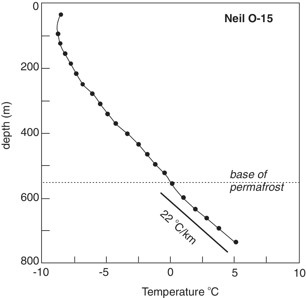
Plot of temperature versus depth for the Neil O-15 well, derived from Chen et al. (2010). Depth to base of permafrost is taken as 0°C. Geothermal gradient is estimated from below that level.
The modern climate monitored at the Eureka meteorological station (140 km to the southwest) has a mean annual air temperature of −19.7°C (−36.1°C in January, +5.4°C in July) and mean annual precipitation of less than 100 mm (Environment Canada).
3. Methods
3.1. Sample collection
Four spring pipes were found through field traverse and areal survey. Weathered surfaces were removed, and fresh samples were collected. In addition, a water sample was collected from the active discharge of spring water from the glacier at the head of Borup Fiord Pass. Waters were filtered through 0.45 μm paper before being collected in HDPE sample bottles. Cations were preserved by addition of ultrapure nitric acid.
3.2. Stable isotope analyses
For
3.3. X-ray diffraction
Qualitative mineralogy of precipitates collected from spring outlets was determined by powder X-ray diffraction with use of relative peak intensity. Samples were ground in an agate mortar and pestle, and the powders were pressed into aluminum sample holders. The powders were analyzed in a Scintag XDS 2000 X-ray diffractometer with Cu-Kα radiation. Minerals were identified on the basis of their dominant peaks, referenced to the Mineral Powder Diffraction File (JCPDS, 1980).
3.4. Water analyses
Chemical analyses were conducted at the Geological Survey of Canada. Alkalinity was determined by a standard end-point titration. Anions were measured by ion liquid chromatography, and cations were measured by inductively coupled plasma emission spectroscopy. Analytical error in concentration measurements was estimated to be less than 2%. H2S was measured by gravimetric methods through precipitation of dissolved H2S immediately after collection through addition of cadmium acetate, which was later filtered and weighed in the laboratory.
4. Results
4.1. Field characteristics
Prominent circular to oval features (hereafter referred to as “pipes”) occur in the proglacial area near the Borup Fiord sulfur spring. They are characterized by a white central core with a rusty red halo (Fig. 4). These features are up to 5 m in diameter. The vertical extent is uncertain given only surface exposures are available; however, one site does indicate a minimum of 2 m depth. The upper surface has a crust that shows signs of weathering and alteration, whereas underneath both the outer red rim and inner white core, the pipes consist of unconsolidated material with a finely granular nature. The material is soft and friable and can be easily scooped by hand. In comparison, the surrounding bedrock is comprised of carbonates that show little alteration beyond normal frost shatter.
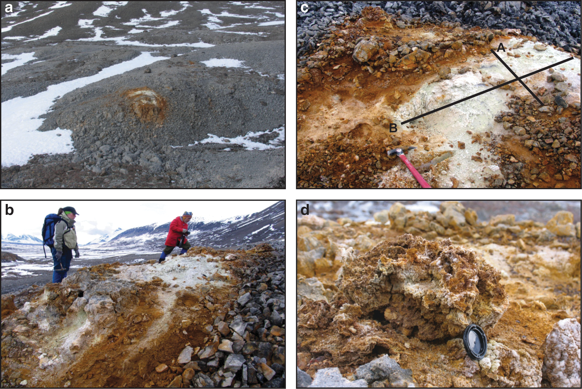
Field photographs showing “pipe” features: (
4.2. Mineralogy
The pipe features occur in a limestone host rock with mineralogy dominated by calcite. A transect of samples was collected across one of the pipe features along two orthogonal axes (Fig. 4c). Variation in mineralogy across the pipe is shown in Fig. 5. From the almost pure calcite limestone on the outer edge, there is a transitional zone of 10–20 cm where the calcite content drops to zero and the gypsum content increases to 100%. This transition zone is marked by red staining by geothite and jarosite. However, the total percentage of these Fe oxides is low except in narrow bands along the outer rim of the pipe feature. The interior of the pipe has up to 15% elemental sulfur, with the remainder being gypsum.

Mineralogy on pipe features based on qualitative X-ray diffraction along two transects shown in Fig. 4c.
4.3. Stable isotopes
The stable isotope values for gypsum in the sampling transects are shown in Fig. 6. In general, δ34S values range between +7.3‰ and +13‰, and δ18O values range between −9.5‰ and −15.8‰. Figure 7 shows a plot of δ34S versus δ18O of spring pipes along with other sulfur compounds in the area. This plot shows that gypsum in the pipes have δ34S values slightly lower than that of marine evaporate deposits in the region (Otto Fiord anhydrites) but with significantly lower δ18O values than the Otto Fiord. Gypsum from the pipe features also have significantly lower δ34S and δ18O values than dissolved sulfate in spring waters or gypsum deposited by the spring on glacier ice. The δ34S values of gypsum from the pipe features are, however, within the range of those observed for H2S at the nearby supraglacial sulfur spring, as well as elemental sulfur deposits. Elemental sulfur in the infill material has δ34S values from +7.4‰ to +14.2‰. The pipe gypsum has similar δ18O values to dissolved sulfate in river water that drains from the valley glacier; however, the δ34S values are ∼20‰ higher.
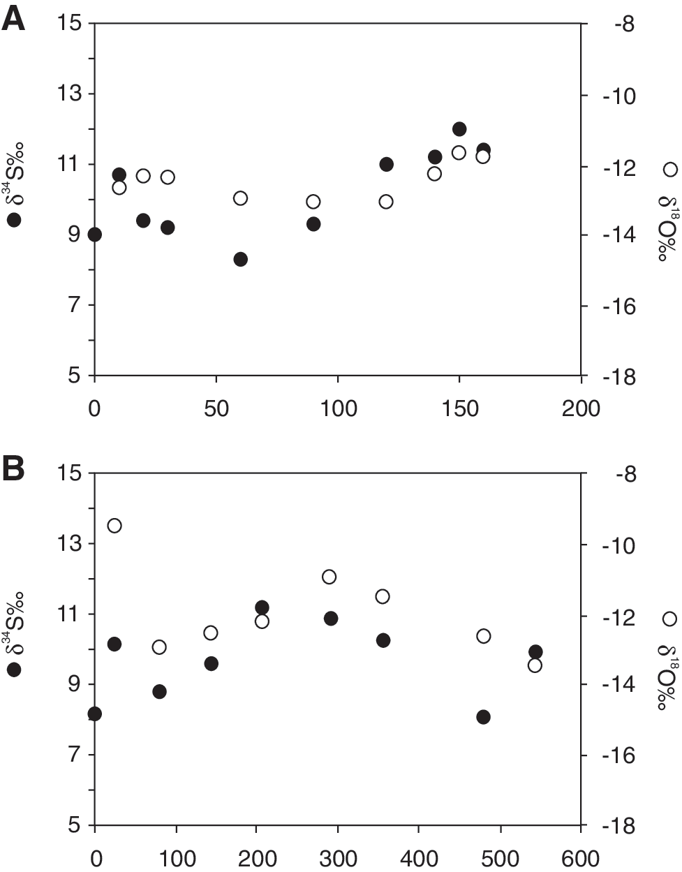
Plot of variation in stable isotope values of sulfur (full circle) and oxygen (open circle) in gypsum in transects across pipe features shown in Fig. 4c.

Cross plot of δ34S vs. δ18O for pipe material, dissolved sulfate and sulfides in spring water, and spring precipitates, showing that sulfates in pipe features are consistent with oxidized spring sulfides.
4.4. Spring water geochemistry
Results show spring water with salinity of 7390 mg/L total dissolved solids (TDS), with dissolved ions dominated by NaCl. Low δ18O values of −25.1‰ indicate that the high TDS is derived from salt dissolution rather than seawater incursion. The TDS reported here is much higher than the original 180 mg/L TDS spring water reported by Grasby et al. (2003a). These original reported analyses were from samples collected later in the summer and were likely significantly diluted by glacial melt water. The samples we report here are from earlier in the season, prior to significant onset of summer glacial melt and from a much more active spring discharge with significantly higher H2S. Dissolved H2S in the spring water is the highest reported from any spring in Canada (140 mg/L). The average δ34S value of dissolved H2S is ∼9‰, whereas dissolved sulfate is ∼29‰.
Calculated saturation indices show that spring waters, where discharging from the ice surface, are oversaturated with respect to calcite and near equilibrium with gypsum, which is consistent with observations of gypsum, calcite, and vaterite precipitation that occur at the spring site (Grasby, 2003; Grasby et al., 2003a). This contrasts with our early report of undersaturated conditions with respect to gypsum; however, this is readily explained by previous water samples being more diluted by glacial melt water.
5. Discussion
Given the soft friable nature of the pipe infill material, these features could not have formed prior to the last glaciation, as they would have been readily scoured by ice or subglacial water flow, or both. The soft infill material instead forms a surface that is continuous with the surrounding bedrock. This suggests the pipe features have experienced very limited erosion and, therefore, must have formed either under the last phase of retreating ice or post–ice cover. While there are no exact dates for ice retreat in our study area, in general glaciers in the Borup Fiord Pass region retreated by 7.5 ka before present (England et al., 2006).
Otto Fiord evaporites are known to form diapiric structures in the Sverdrup Basin; however, they are typically on the tens of kilometers scale diameter. If gypsum that forms the pipe infill material was derived from Otto Fiord evaporates (either directly as diapir-like intrusions into overlying rock or indirectly as dissolution and re-precipitation of evaporite minerals), then the δ34S and
Under anaerobic conditions, microbial activity can reduce SO4 in the system and produce H2S. Microbial sulfate reduction is evident in the modern spring at Borup Fiord (Grasby et al., 2003a; Gleeson et al., 2010) and generates up to 140 mg/L dissolved H2S in the discharge water. Production of H2S can result in pyrite mineralization through reaction with dissolved Fe. This may explain the abundant pyrite mineralization along the fault zone associated with the spring system. It was previously noted that pyrite along this fault has the same range of δ34S values as dissolved H2S in the active spring system (Grasby et al., 2003a).
As waters ascend toward the oxic surface environment, H2S will rapidly convert back to SO4. During oxidation of sulfide, 60% to 100% of O2 is derived from water, whereas the rest is derived from air (Lloyd, 1968; Van Stempvoort and Krouse, 1994). The value of oxygen in reoxidized sulfate (δ18OOX) will then be the sum of the relative contributions of O from these two sources, water (
where y is the fraction of O derived from water, and ɛ is a kinetic fractionation factor. Abiotic oxidation of sulfide goes through many intermediate steps, which makes
During sulfate reduction, a Raleigh-type fraction should occur, whereby the reduced sulfur is lower than the original sulfate source and remnant sulfate has higher δ34S values. This is evident in the modern spring system where reduced sulfur (H2S and S0) has lower values than those of the source Otto Fiord evaporites, and residual dissolved sulfate has much higher values (Grasby et al., 2003a). In a closed spring system (i.e., along the underground flow path), the reduction and reoxidation of sulfate can have limited net fractionation of sulfur, especially if most sulfate that is reduced to sulfide becomes reoxidized (Grasby et al., 2000b). If this is the case, then reoxidized sulfur should not have significantly lower δ34S values than those of the original source. For H2S in the spring waters, we see that δ34S values are only ∼5‰ lower than Otto Fiord Formation anhydrites.
Pipe infill gypsum has
6. Model for Pipe Formation
6.1. Sulfuric acid speleogenesis
Stable isotope data, supported by microbial studies, show that active microbial sulfur cycling is occurring (sulfate reduction and sulfide oxidation) in the Borup Fiord Spring system (Grasby et al., 2003a; Gleeson et al., 2010). Sulfate in the spring waters has sulfur isotope values consistent with Otto Fiord Formation anhydrites that have dissolved and undergone Rayleigh fractionation, which makes anhydrite dissolution the most reasonable source of sulfur in the system (Grasby et al., 2003a). Microbial reduction of sulfate by oxidation of organic acids can be expressed as below (Manning, 1997):
This process explains the extraordinary high H2S levels in the modern spring system. Recent work has also demonstrated the important role of microbial sulfide re-oxidation of H2S in cave formation, through sulfuric acid speleogenesis (SAS) (Polyak and Provencio, 2000; Grasby et al., 2003b; Boston et al., 2006), whereby subaqueous microbial sulfide oxidation produces sulfuric acid that in turn lowers carbonate saturation and leads to calcite dissolution:
The net reaction causes SAS, whereby carbonates are dissolved and replaced by gypsum, as expressed as
Sulfide oxidizers also commonly form elemental sulfur (S0) as an intermediate by-product by
Where observed to occur in cave systems, SAS forms reaction by-products, including gypsum, elemental sulfur, and jarosite in the acid sulfur system (Polyak and Provencio, 2001).
In local reaction zones, very low pH waters can form (pH <3) (Polyak and Provencio, 2000; Grasby et al., 2003b). However, Engel et al. (2004) showed that SAS does not affect bulk water chemistry; instead it occurs within surface biofilms, where microbial activity locally changes pH conditions such that calcite dissolution and gypsum precipitation occur in microenvironments at the mineral/water interface. As such, Engel et al. (2004) showed that SAS occurs even though bulk waters are near equilibrium with calcite and undersaturated with gypsum. This explains how SAS could occur at the Borup Fiord site even though modern spring waters are observed to be oversaturated with carbonates at the spring outlet. In addition, it can explain the apparent discrepancy as to how oxygen isotopes in the gypsum pipes have
Partial oxidation of H2S can also lead to the formation of elemental sulfur. This is observed only in the core of the pipes, which suggests that it is related to the redox gradient across the pipe, where the outer core has greater oxidation potential. The outer rim of the pipe features is characterized by Fe oxides, goethite, and jarosite, which indicates that it was formed under oxidizing conditions, consistent also with reaction by-products of SAS in cave systems in New Mexico (Polyak and Provencio, 2001).
6.2. Permafrost advance and freezing of spring channel
Groundwater-fed spring systems, as found in the Borup Fiord Pass described in this paper, are not readily explainable in environments of thick permafrost. The occurrence of groundwater discharge from underneath permafrost hundreds of meters thick requires a continuous pathway through the permafrost along which the rock is unfrozen. Elsewhere, the permeability of aquifers will be almost entirely lost where groundwater is frozen and ice occupies pore space (Kleinberg and Griffin, 2005). Across areas of continuous permafrost, infiltration and discharge of groundwater from, or to, subpermafrost aquifers are commonly limited to unfrozen zones (taliks) in the aquifer that occur underneath relatively deep water bodies that provide enough insulation to maintain an unfrozen bed throughout the season (e.g., Burn, 2002). Also, underneath continental ice sheets and glaciers, unfrozen bed conditions might exist, depending on the subglacial heat budget governed by surface temperature, geothermal heat flow, and heat sourced from friction with the substratum (e.g., Boulton et al., 1993). Where, under the right conditions, temperature is at, or above, the pressure melting point, liquid water is present at the ice bed. If this is the case, permafrost is potentially absent, and subglacial water can infiltrate into the underlying bedrock. Such conditions are known to be common for polythermal glaciers in the Canadian Arctic Islands (Blatter and Hutter, 1991; Bingham et al., 2008; Wohlleben et al., 2009).
We hypothesize that transient groundwater discharge in springs in the proglacial area of the Borup Fiord Pass, and underneath the ice near the glacier snout, can be explained by the model summarized in Fig. 8. Topography-driven groundwater flow requires that groundwater discharge is balanced by groundwater recharge in areas that allow infiltration of surface water. In the absence of significant precipitation in the area, infiltrated subglacial water seems the only plausible source of water to provide recharge to the spring systems. Consequently, underneath at least some of the ice-covered areas, permafrost will have to be absent to allow for the recharge of deep groundwater. In the fractured basement rocks of the area, groundwater movement is likely to be constrained to fault zones and associated fracture networks, similar to the prominent fault previously proposed to control spring flow in the Borup Fiord area (Grasby et al., 2003a). Groundwater flow will be focused along high-permeability pathways in these rocks. High water pressure at the base of the ice in response to the weight of the overlying ice will force recharge of available water along high-permeability zones in the underlying rock. When the proglacial area is covered by permafrost, this water will be forced to discharge underneath the ice where the ice is thinner and hydraulic head at the base is lower, but not so thin that the temperature at the base of the ice is below the pressure melting point and permafrost would develop and hamper groundwater discharge. In this situation, subglacial springs can be expected to occur near the ice margin near the boundary of wet-based and frozen bed conditions (Fig. 8a). If the temperature and discharge of the subglacial spring water are high enough, it can possibly reach the ice surface via a flow path through the ice facilitated by open features such as crevasses. When under warming climatic conditions, the ice becomes thinner, and eventually a subglacial spring will be exposed to the atmosphere. However, when the thermal insulation of the ice cover is removed, permafrost will start to develop from the surface downward (Fig. 8b). The rate of permafrost growth from the surface down will generally be considerably slower than the rate of exposure of the bedrock from underneath the ice so that the condition depicted in Fig. 8b can be maintained for a while. Although the rate of infiltrating melt water from wet-based parts of the ice base near the snout of the ice sheet will be affected when the ice thins, and temperature might drop below the pressure melting point underneath these parts of the ice cover, the regional flow component, which is fed by subglacial water from adjacent mountains, can be expected to persist at this stage. A spring in this setting can remain flowing, in an otherwise frozen landscape, for a limited amount of time, as it eventually will be cut off by encroaching permafrost (Fig. 8c).

Conceptual model for formation of spring pipes due to retreat of the glacial front and advance of permafrost. (
The timescale over which the sequence depicted in Fig. 8 unfolds will depend on a set of parameters. Once the spring is established in the proglacial area, the flow rate of the spring in combination with the heat transport keeps the spring outlet open. The net heat flux will control how long the spring can remain flowing before growth of the surrounding permafrost cuts off the flow path that feeds the spring, which will result in the spring mound freezing over.
In this scenario, it can be understood how, progressively during ice-sheet retreat, a series of fossil spring pipes will develop as observed in Borup Fiord Pass. This model requires that the Borup Fiord glacier is wet-based, at least in places, which would allow the outflow of deeper groundwater via permafrost-free zones. The date when these springs first emerged should therefore be increasingly younger toward the present ice margin. This, however, has not as yet been tested.
7. Implications for Astrobiology
Clifford and Parker (2001) suggested that subglacial recharge beneath Mars' polar icecaps could drive a martian groundwater system. If such a mechanism occurs, then our model for spring formation in glaciated regions of thick permafrost provides a scenario where active (or paleo) springs could potentially be found near ice margins on Mars. As previously suggested (Grasby and Londry, 2007), such spring systems may have formed important refuga during the drying phase of Mars and could have formed important potential habitat for astrobiological investigation. The ice margins of polar icecaps on Mars should be important regions for the search for potential spring systems. While carbonate rocks have been difficult to find on Mars, recent discoveries suggest that they may be more widespread than previously considered (Ehlmann et al., 2008; Michalski and Niles, 2010). Our work here shows that such discharge sites form distinct physical features in the rock record where SAS could occur. These sites could form prime targets for astrobiological investigations.
8. Conclusions
Our results show that pipe features in the proglacial area at Borup Fiord Pass are consistent with SAS that occurs in the subglacial environment. We argue that these features are formed by carbonate dissolution and precipitation of reaction by-products dominated by gypsum and elemental sulfur. As such, these features form distinct evidence for paleo-spring discharge in the proglacial area of the Borup Fiord Pass glacier.
We provide a conceptual model to explain the apparent recent abandonment of these spring channels in response to glacier recession and advance of permafrost that would cause “freezing in” of the spring system. The conclusion that these paleo- and current spring systems in the polar environment found in the Borup Fiord Pass area are fed by groundwater is significant. An explanation for the emergence of deep groundwater requires the presence of a recharge area. The only candidate is subglacial recharge, which provides evidence for significant glacially driven hydrogeological processes.
Our results provide a potential analogue for groundwater systems that may form in association with Mars' polar icecaps and potential characteristics of relic spring systems that may record such activity in the rock record. These results may help focus the search for potential astrobiological sites on Mars.
Footnotes
Acknowledgments
Helpful reviews by Joseph Levy and an anonymous reviewer are greatly appreciated. ESS Contribution: 20110208.
Abbreviations
SAS, sulfuric acid speleogenesis; TDS, total dissolved solids.