
Abstract
Sandstone beds of the <3.7 Ga Gillespie Lake Member on Mars have been interpreted as evidence of an ancient playa lake environment. On Earth, such environments have been sites of colonization by microbial mats from the early Archean to the present time. Terrestrial microbial mats in playa lake environments form microbialites known as microbially induced sedimentary structures (MISS). On Mars, three lithofacies of the Gillespie Lake Member sandstone display centimeter- to meter-scale structures similar in macroscopic morphology to terrestrial MISS that include “erosional remnants and pockets,” “mat chips,” “roll-ups,” “desiccation cracks,” and “gas domes.” The microbially induced sedimentary-like structures identified in Curiosity rover mission images do not have a random distribution. Rather, they were found to be arranged in spatial associations and temporal successions that indicate they changed over time. On Earth, if such MISS occurred with this type of spatial association and temporal succession, they would be interpreted as having recorded the growth of a microbially dominated ecosystem that thrived in pools that later dried completely: erosional pockets, mat chips, and roll-ups resulted from water eroding an ancient microbial mat–covered sedimentary surface; during the course of subsequent water recess, channels would have cut deep into the microbial mats, leaving erosional remnants behind; desiccation cracks and gas domes would have occurred during a final period of subaerial exposure of the microbial mats. In this paper, the similarities of the macroscopic morphologies, spatial associations, and temporal succession of sedimentary structures on Mars to MISS preserved on Earth has led to the following hypothesis: The sedimentary structures in the <3.7 Ga Gillespie Lake Member on Mars are ancient MISS produced by interactions between microbial mats and their environment. Proposed here is a strategy for detecting, identifying, confirming, and differentiating possible MISS during current and future Mars missions. Key Words: Astrobiology—Life on Mars—Microbial mats—MISS—Biosignature—Curiosity rover. Astrobiology 15, 169–192.
1. Introduction
T
The first step in an astrobiology search strategy is to locate aquatic environments that may have constituted habitats for life and have high preservation potential. Sedimentary deposits that formed in ancient oceans, rivers, or lakes are good candidate rocks for astrobiology searches. On Mars, ancient playa lake settings are quite common (e.g., Grotzinger et al., 2005; Metz et al., 2009; Zheng et al., 2013). Playas are clastic-evaporite settings that experience periodic (seasonal) flooding by shallow water of some centimeters' depth with subsequent subaerial exposure and desiccation of the sedimentary surfaces. On Earth, and presumably on Mars, playas are typical for a semiarid climate zone. During the periods of subaerial exposure of sedimentary surfaces in a playa, salt minerals precipitate atop and within the sediment. On Earth, clastic-evaporitic playas are known from the oldest sedimentary rock record 3.48 Ga to the present time. Throughout Earth history, playa sediments have been colonized by benthic microbial mats dominated by filamentous cyanobacteria that interact with the physical sediment dynamics at their sites of colonization to form characteristic microbialites known as microbially induced sedimentary structures (MISS) [detailed overview on the interaction of biofilms with hydraulic and physical sediment dynamics in Noffke (2010)].
Precipitation of mineral particles observed in stromatolites (for carbonate examples see e.g., Reid et al., 2000; Awramik and Grey, 2005; Kremer et al., 2008; Dupraz et al., 2009) does not take place in MISS-forming microbial mats (Supplementary Fig. S1; Supplementary Data are available online at
Microbially induced sedimentary structures occur in many Phanerozoic and Precambrian rocks (e.g., Gerdes and Krumbein, 1987; Hagadorn et al., 1999; Schieber et al., 2007; Noffke, 2010; Noffke and Chafetz, 2012; Beraldi-Campesi et al., 2014). To date, 17 types of MISS are distinguished (Supplementary Fig. S2), defined by their specific geometry and their mode of formation (a detailed description of all MISS can be found in, e.g., the work of Schieber et al., 2007, or Noffke, 2010). Examples of MISS include “erosional remnants and pockets” (Supplementary Figs S3 and S4), “mat chips,” and “roll-ups” (Supplementary Fig. S5).
Studies of MISS throughout Earth history have shown that the earliest MISS have the same morphologies and diversity as their modern counterparts (Noffke and Awramik, 2013). Examples of MISS in the 3.48 Ga Dresser Formation, Pilbara, Western Australia are the oldest uncontested biogenic structures in the geological record (Noffke et al., 2013). The Dresser Formation records an ancient evaporite setting (e.g., Buick and Dunlop, 1990; Van Kranendonk et al., 2008; Noffke et al., 2013). Another example of upper Archean MISS is the 2.9 Ga Pongola Supergroup, South Africa, which records an ecosystem characterized by exceptionally well preserved MISS types in clastic-evaporite sabkha deposits (Noffke et al., 2008). Because playas occur on Earth as well as on Mars, MISS are listed as one of the target biosignatures for the NASA Mars Exploration Rover program (Committee on an Astrobiology Strategy for the Exploration of Mars, 2007).
The Hesperian epoch of Mars is of similar age to the MISS-bearing Archean rocks on Earth; the question for this study was whether such old martian rocks would include evidence for fossil MISS as well. This contribution describes sedimentary structures from an ancient playa lake environment recorded by the <3.7 Ga Gillespie Lake Member on Mars. The structures show morphologies and spatial and temporal distribution patterns that are similar to those of MISS on Earth. Hence, the hypothesis of this work is as follows: The sedimentary structures in the <3.7 Ga Gillespie Lake Member on Mars are ancient MISS produced by the interaction of microbial mats and their environment.
2. The <3.7 Ga Gillespie Lake Member, Mars
2.1. Location and stratigraphic setting
The Mars rover Curiosity is presently exploring the geology of Gale Crater, which includes a sedimentary rock succession called Yellowknife Bay (detailed description in Grotzinger et al., 2014; Farley et al., 2014; see also Supplementary Fig. S6). Gale Crater has a maximum age of 3.7 Ga (Hesperian epoch). The 5.2 m thick Yellowknife Bay rock succession is composed of the Sheepbed Member (predominantly a mudstone facies), the Gillespie Lake Member (a sandstone facies), and the Glenelg Member (a sand and siltstone facies). The sedimentary rocks record a fluvio-lacustrine paleoenvironment. Unlike surfaces of similar ages on Earth, the sedimentary surfaces of post-Noachian time on Mars are relatively well preserved, and the rates of erosion would have been significantly less (e.g., Carr and Head, 2010).
2.2. Paleoenvironmental reconstruction of the Gillespie Lake Member
The sedimentary structures described in this contribution occur in the 2 m thick Gillespie Lake Member. The base of this rock succession is marked by an erosive sandstone bed that cuts into the underlying Sheepbed Member. This bed forms an approximately 5–20 cm high geomorphological cliff that can be easily seen in outcrop. The grains of this sandstone bed are poorly sorted and angular to moderately well-rounded. The detrital sandstone that forms the bulk of the Gillespie Lake Member has a basaltic composition with medium to coarse grain sizes. The grain sizes become smaller toward the top of the succession. Cross-bedding has been identified in some of the sandstone beds, and some of the exposed planar surfaces of the sandstones appear to contain channels a few centimeters to decimeters deep and up to 50 cm wide [not to be mistaken for the large-scale, straight tectonic fractures caused by decompression of the rocks during their exhumation by recent erosion (Linda Kah, personal communication, 2014)]. Vertically oriented veins and fractures on the bedding surfaces are filled by Ca-sulfate minerals of different hydration state (e.g., anhydrite and gypsum). These mineral assemblages were caused by water circulating through the sediments syndepositionally or during early diagenesis. The water was probably derived from a basin-wide hydrological system (Grotzinger et al., 2014). The presence of scour marks at the base of the Gillespie Lake member and of channels in the otherwise flat-topped rock beds is interpreted as resulting from seasonally alternating wet and dry paleoclimate (Grotzinger et al., 2014). The transition toward the top of the sedimentary succession to a playa lake environment in an ancient distal fan setting is consistent with the local paleoclimate becoming drier over time. A similar sequence of sedimentary structures records an increase in the aridity in Quaternary to modern playas on Earth (Bowen and Johnson, 2012; Miguel and Malte, 2014). McLennan and coauthors (2014) proposed that, at that time, the salinity of the martian paleoenvironment was low to modest and the pH values were neutral.
This contribution evaluates the macroscopic morphological attributes of sedimentary structures identified in two different rock beds (Figs. 1, 3, and 5) and in a short succession of rock beds (Fig. 9) of the Gillespie Lake Member of sediments on Mars. The medium to coarse grain size of the Gillespie Lake sandstone is interpreted as typical for a fluvial-lacustrine setting of 20 cm/s or less average flow velocities (Middleton, 1976). Such a moderate hydraulic window is dynamically suitable for the establishment of microbial mats (Noffke, 2000; Noffke et al., 2002; “hydraulic window of mat development,” Noffke, 2010). The rock bed surfaces studied are well preserved and do not show significant alteration by eolian (wind) abrasion or deposition. Extensive wind abrasion over time would have produced centimeter- to decimeter-sized eolian sedimentary structures on the bedding surface, which could include for example sand drifts and dunes, sand sheets, sand strips, wind ripples, and ventifacts (for Earth, e.g., Reineck and Singh, 1980; for Mars, e.g., Thomas et al., 2005). The rock bed surfaces also show no evidence of a deflation process that would be evidenced by the accumulation of coarse-grained pebbles atop the sedimentary surface that were too heavy to be removed by the wind. As the Gillespie Lake rocks are thought to have been exhumed only recently (Grotzinger et al., 2014), any possible surface distortion by wind should be minimal.

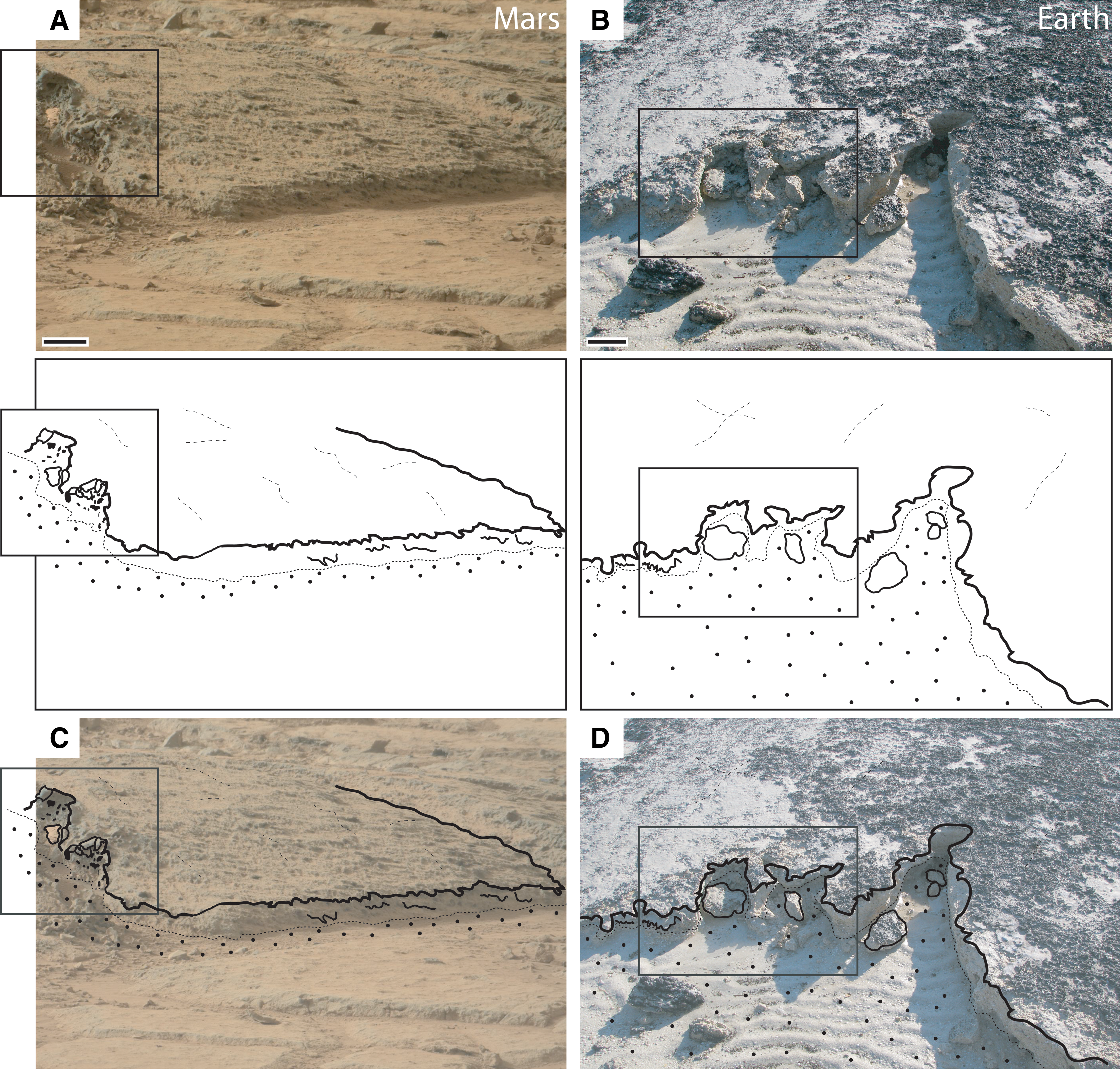
Overview of Rock Bed 1, Location 1, of the <3.7 Ga Gillespie Lake Member, Mars. (
Described in detail below is a set of unusual sedimentary structures observed in unprocessed Mastcam photographs (
3. Macroscopic Morphological Comparison of the Sedimentary Structures in the <3.7 Ga Gillespie Lake Member, Mars, with Terrestrial MISS
3.1. Rock Bed 1, Location 1
3.1.1. Elevated and irregular rock surface morphologies
An elevated planar surface on Mars, located in the upper left of Fig. 1 and shown magnified in Fig. 2, reveals distinctive macroscopic morphological characteristics that are comparable to those of erosional remnants of modern and ancient MISS on Earth.
Comparison of the elevated and planar surface portion visible on Rock Bed 1, Location 1, of the <3.7 Ga Gillespie Lake Member, Mars (
The elevated planar surface on Mars is defined by a 3–5 cm high cliff; the angle of the cliff varies from approximately 5° to 90°, and the edge of the cliff face on the right of the platform displays surface features characterized by triangle-shaped protrusions that point down and away from the platform (Fig. 2A, 2C). On Earth, erosional remnants of MISS are produced when cohesive microbial mats remain intact and give rise to isolated, elevated planar surfaces (e.g., Fig. 2B). In modern near-shore settings, the steep angled slopes of elevated, planar surfaces of erosional remnants of MISS record a characteristic edge morphology characterized by triangle-shaped protrusions that form when cohesive microbial mats hang down over the slope and become lithified (e.g., Fig. 2D).
Beyond the elevated surface and toward the right of the Mastcam photograph shown in Fig. 1 are several round-shaped depressions, some of which are surrounded by a half-moon-shaped ridge. In the foreground of Fig. 1, the rock bed surface appears irregular and “crumpled”; lineations, depressions, and small ridges cover the sedimentary surface in a seemingly random pattern (see additional discussion in Supplementary Figs. S7 and S8). Several of the larger lineations, which are slightly irregular, bend with no preferred direction, as illustrated in the sketches. Flat clasts and fragments are also visible in the images and noted in the sketches.
3.1.2. Interpretation of irregular rock surface morphologies
Modern MISS at Portsmouth Island, USA, illustrate examples of erosional remnants and pockets, roll-ups, and mat chips (terrestrial examples shown in Fig. 3; Supplementary Figs. S7 and S8). These sedimentary surfaces were originally overgrown by cohesive, carpetlike microbial mats that, during the fall of 2008 when storm frequency and intensity increased, were partially eroded by strong water currents. The originally smooth microbial mats that covered the entire area were ripped into large, meter-scale pieces; some of the ripped-up pieces of mat were rolled up, while other pieces were just folded. The anomalously strong current also produced small erosional pockets (see also Supplementary Figs S3 and S4). Modern roll-up structures are often preserved alongside shallow depressions and very narrow, elongated erosional pockets (Supplementary Fig. S9).
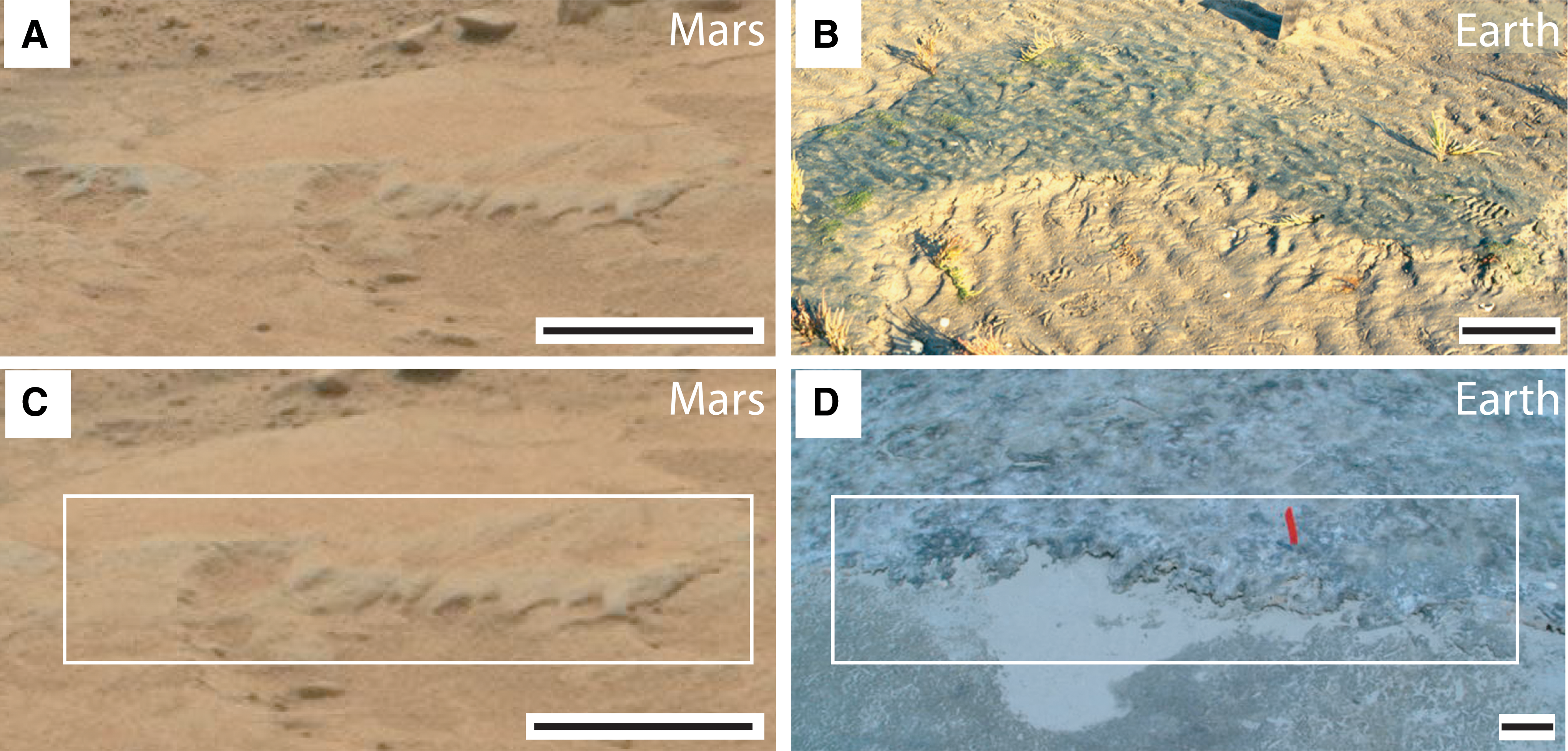
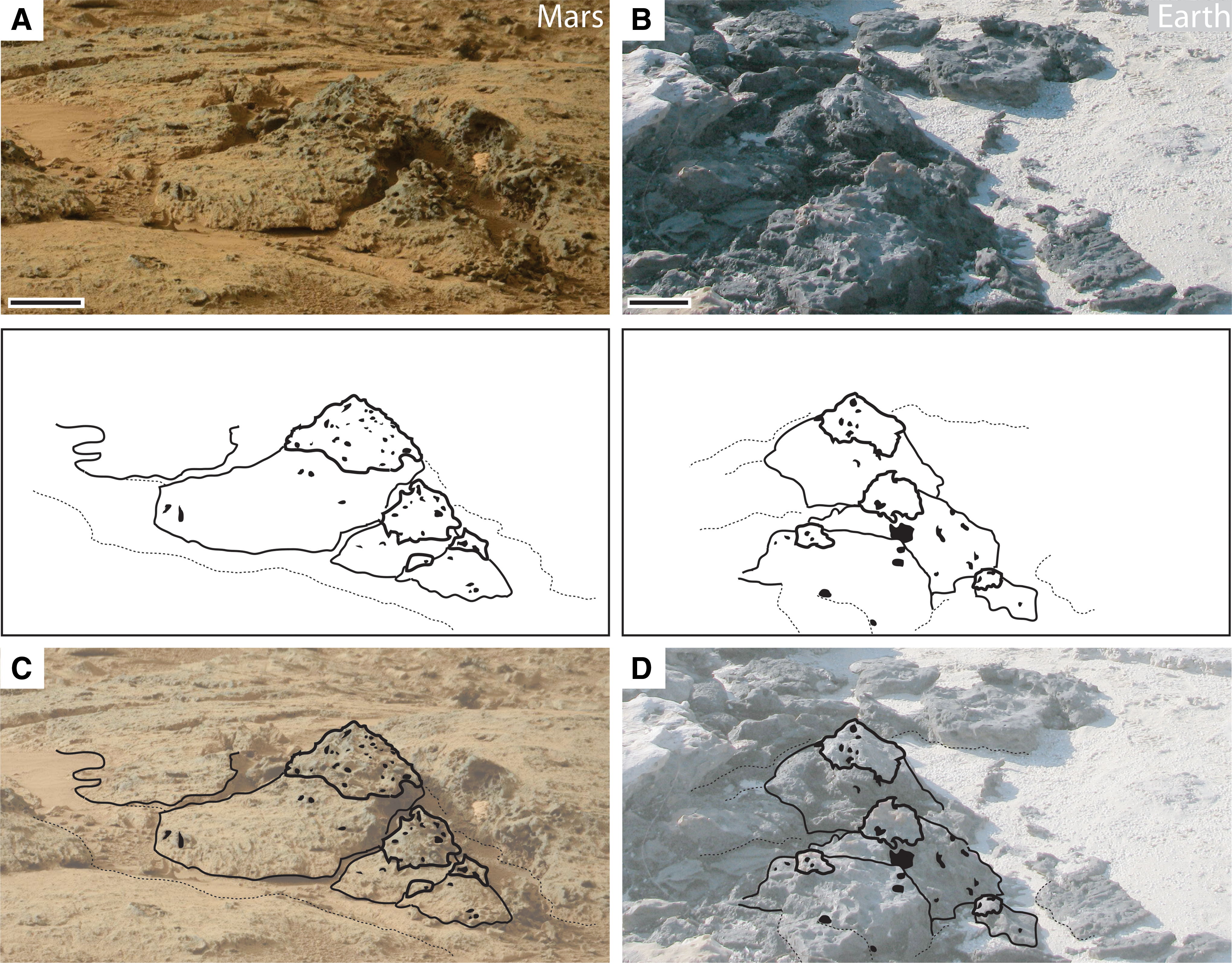
Comparison of sedimentary structures on Rock Bed 1, Location 2, of the <3.7 Ga Gillespie Lake Member, Mars. (
3.2. Rock Bed 1, Location 2
3.2.1. Oval-shaped depressions associated with ridges and clasts
A second view of Rock Bed 1 taken from a different perspective, as shown in the Mastcam photographs of Figs. 3 and 4, illustrates additional MISS-like structures in the same general area: round- to oval-shaped depressions are associated with triangular-shaped structures, small half-moon-shaped ridges, and flat clasts. In the large, oval- to round-shaped depression on Mars are three faint ripple marks in the bottom of the depression and a flat isolated clast. The magnified image of the depression shown in Fig. 4 reveals that it is associated with a straight-to-curved ridge along the left side of the depression. Along the back edge of this depression are triangle-shaped centimeter-scale structures that appear to point downward and in toward the base of the depression (Supplementary Fig. S10A). A few flat clasts occur along the left end of the depression, at the base of the depression, and on the sedimentary surface that surrounds the depressions (Figs. 3 and 4). Note that the flat clast in the Mars depression appears to “drape” the edge and sits on top of the base of the depression, which is consistent with the sediment having some cohesiveness and ductility at the time of formation.
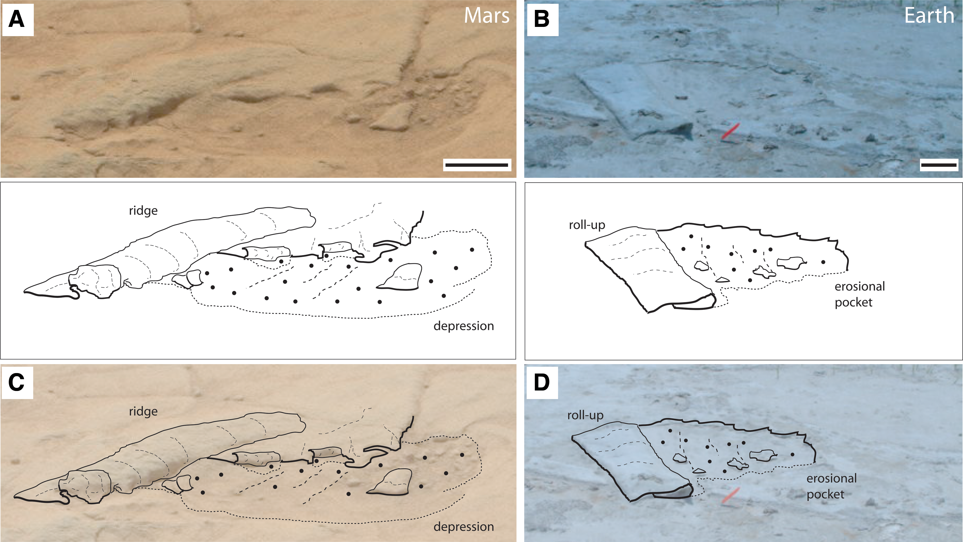
Curiosity rover Mastcam photograph 0126MR0782004000E1_DXXX shown in magnified view (
3.2.2. Interpretation of the oval-shaped depressions associated with ridges and clasts
As shown in the photograph and sketch of a terrestrial erosional pocket on a modern sedimentary surface at Portsmouth Island, USA, the ridges resemble the fringes of ancient (Supplementary Fig. S10B) and modern (Supplementary Fig. S10C) terrestrial microbial mats that were ripped apart along the edges of the erosional pockets at the time they were disrupted. Illustrated in the bottom of the terrestrial erosional pocket shown in Fig. 4 are isolated fragments of cohesive microbial mat. When lithified, these fragments of cohesive mat are referred to as “mat chips,” and they are preserved as flat clasts in the geological record. Although a statistically valid analysis of the orientation of the clasts associated with the martian depressions is not possible due to the low number of examples observed in the Mastcam photographs, the ratio of the longest diameter/thickness (in mm) of the largest terrestrial mat chips shown in Fig. 4B ranges from 16.6 to 24 (n=10), and those of the two clasts at the left end of the martian erosional pocket shown in Fig. 4A are 33 (n=2). The main isolated flat clast in the Mastcam photograph (Fig. 4A) resembles morphologically a cohesive microbial mat that was rolled up in a current and flapped back onto itself. Additional examples of flattened roll-up structures of terrestrial modern microbial mats are shown in Supplementary Fig. S5.
In summary, these two locales at the Rock Bed 1 site on Mars display a variety of sedimentary structures that have macroscopic morphologies similar to erosional remnants and pockets that have been found throughout Earth history; they are characterized by fringed microbial mat edges and flat or rolled-up microbial mat chips. In the modern terrestrial evaporite ecosystem at Portsmouth Island, the same water current that ripped off and rolled back the original microbial mat cover and formed a roll-up MISS also produced the ripple marks at the bottom of the depression (see also Supplementary Fig. S11 for such examples of rippled erosional pockets). The spatial relationship of the terrestrial MISS is similar to that of comparable structures on Mars at the Rock Bed 1 locales: ridges occur only on one side of the depressions, and ripple marks on the bottoms of the depressions are oriented parallel to the ridges.
If the sedimentary structures at Locations 1 and 2 of Rock Bed 1 of the Gillespie Lake Member formed by water currents that interacted with microbial mats and biostabilized sediments, a paleoenvironmental reconstruction of the flow path can be made based on the orientation of MISS-like structures (Figs. 1D and 3E): the rose diagrams indicate that the predominant water current would have crossed the mat-covered sedimentary surface in a direction that trended from the lower right to the upper left corners of the Mastcam photos shown in Figs. 1 and 3. Such anomalously strong currents would have produced roll-up structures oriented in the same direction and moved mat chips away from the positions where they were originally ripped off from cohesive mat structures.
3.3. Rock Bed 2
3.3.1. Pits, flat clasts, and cracks
Additional types of MISS-like structures were identified in Mastcam photographs of the surface of Rock Bed 2 (Fig. 5 and Supplementary Figs. S12, S14, and S15): centimeter-scale pits of irregular but generally round to ellipsoidal shapes. Though the sizes of the pits are difficult to determine in the Mars imagery, the longest diameters of these small pits (Supplementary Fig. S12A) appear to range from approximately 2 to 8 cm. The distribution of the pits does not seem to be random; rather they are grouped into assemblages that each loosely define a polygon (Supplementary Fig. S13). The longest diameters of the polygons are between 50 and 70 cm (approximate values). Rock Bed 2 is also littered with centimeter-scale flat clasts with edgy corners and irregular shapes (Supplementary Fig. S14A). An irregular polygonal pattern of cracks or fractures characterizes this rock surface. Two generations of cracks were identified: one is more visible in the Mastcam photographs than the other (Supplementary Fig. S15A). The morphology of the cracks appears bent and sometimes defines a lensoid-shaped area in between them. The cracks are angular where their direction changes via a narrow curvature.

Curiosity rover Mastcam photograph 0126MR0781001000E2_DXXX of Rock Bed 2, <3.7 Ga Gillespie Lake Member, Mars. The photograph in (
3.3.2. Interpretation of pits, flat clasts, and cracks
The sizes of the small irregular holes in modern terrestrial microbial mats, such as those shown in Supplementary Fig. S12B, are between 2 and 5 cm. A distribution pattern similar to that of the holes in modern microbial mat surfaces (Supplementary Fig. S12B) can be observed in the distribution pattern of the pits observed at this site on Mars (Supplementary Fig. S12A). The distribution pattern of holes in the mats groups into assemblages that each loosely define polygons (Supplementary Fig. S13B), similar to the grouping of pits observed in the Mastcam photographs (Supplementary Fig. S13A). On Earth, holes in microbial mats are the result of continuous upward gas flow from the sediment beneath the mats. Once a gas dome is established underneath a mat, a vertical cross section through such a gas dome would reveal that the convex shape of the microbial mat separates it from its substrate beneath and forms a hollow cavern beneath the mat; the gas dome later bursts open and leaves a hole in the mat. Such structures are the sites where continuously upward migrating intra-sedimentary gases are released into the atmosphere.
There appears to be a relationship between the sizes of the polygons produced by the groupings of pits at this location on Mars and the sizes of the holes produced in terrestrial mats due to gas dome rupture. The ratio of the longest diameter of the terrestrial polygons to that of the diameters of the holes is approximately 16. On Mars, though exact measurements were not possible, the ratio of the longest diameters of the polygons to the diameters of the pits (all shapes) was 18. This similarity in the ratio of the Earth and Mars examples may be just a coincidence. However, on Earth, large gas domes generate mat polygons, each of which is separated from its neighboring polygons by a crack; in the areas where the cracks are overgrown by subsequent microbial mat generations and “healed,” additional gas domes do not form (see Noffke, 2010, for details).
The clasts observed in the Mastcam photographs are similar in morphology to terrestrial mat chips (Supplementary Fig. S14A, S14B). Shapes and sizes of both populations of structures, the martian and terrestrial ones, appear to correspond. However, statistical analysis of the morphometry would produce large uncertainties because of the low numbers of chiplike structures on the surface of martian Rock Bed 2. It is noteworthy that, in the photographs of modern terrestrial mat chips, they appear faint and difficult to distinguish. The reason is that isolated mat chips tend to regrow very quickly (within hours to a few days) and essentially adhere to and integrate with their new substrate. Hypothetically, the similar faint appearance of the clasts visible on Mars Rock Bed surface 2 may have been caused by a similar situation, with ancient microbial mats reestablishing themselves wherever the fragments were hydrologically stabilized. In addition to the flat clasts, some pebbles, which appear as distinct objects in the Mastcam photograph, can be seen on the surface of Mars Rock Bed 2 (Supplementary Fig. S14A). The pebbles appear as distinct features in the Mastcam photographs, which means that they were not integrated due to regrowth of mats onto the sedimentary surface after deposition.
The surface of Rock Bed 2 on Mars also displays two generations of cracks (Supplementary Fig. S15A). The proposed analog terrestrial examples shown in Fig. 6 and Supplementary Fig. S15B display macroscale morphological similarities and a similar spatial arrangement. The first generation of cracks that formed in the modern terrestrial mat is visible, but only as faint parallel lines on the surface. Such cracks are referred to as having been “healed”; that is, even though the cracks opened, their vertical topography is smoothed, and they appear to have been closed again due to microbial mat overgrowth. The second generation of cracks that formed later is still visible in the terrestrial modern mat; the cracks are defined by two lines that run parallel to one another. The mat margins along the cracks are curled upward and outward.

Comparison of cracks shown in Curiosity rover Mastcam photograph 0125MR0007760010200783E1_DXXX-br2 of the surface of Rock Bed 2 of the <3.7 Ga Gillespie Lake Member, Mars (
4. Spatial Associations of MISS on Earth and Comparison with Sedimentary Structure Association in the Gillespie Lake Member, Mars
Throughout Earth history, MISS in evaporite settings are typically grouped into distinct “structure associations” that record distinct environmental facies. One structure association (referred to here as Structure Association 1) includes erosional remnants and pockets, “fringed edges” along erosional remnants and pockets, roll-ups, mat chips, and cracks. This structure association is typical for facies settings that are subject to episodic flooding of otherwise subaerially exposed depositional areas, for example, the morphologically higher areas of a sabkha margin. Another structure association (referred to here as Structure Association 2) includes holes (often in polygonal distribution patterns) produced by burst gas domes in mats, multiple generations of desiccation cracks, and mat chips. This association is typical for pools a few centimeters deep in sabkhas that dry out completely during the dry season of depositional areas located in the semiarid climate zone.
As illustrated in the Venn diagrams shown in Fig. 7, these structure associations are characteristic of MISS in modern, recent, and ancient sedimentary successions. Examples of these distinct and overlapping structure associations are found in the modern evaporite settings at Portsmouth Island, USA, and Bahar Alouane, Tunisia; in Pleistocene playa lake sediments cropping out at the Mediterranean coast, Tunisia; and in Archean sabkha deposits of the Pongola Supergroup in Africa and the Dresser Formation in Australia. As noted, the common set of MISS at all these sites includes microbial mat chips and cracks, whereas all other sedimentary structures are found in one or the other structure association noted above.

Venn diagram illustrates the types of distinct and overlapping structure associations that exist in modern and lithified terrestrial MISS; each sedimentary structure association corresponds to a facies association, which records a specific environmental setting. Structure Association 1 on Earth is typical for settings that are subject to episodic flooding of an otherwise subaerially exposed depositional area, for example, the morphologically higher areas of a sabkha margin. Structure Association 2 on Earth is typical of the structures formed in association with pools in sabkhas that dry out completely only during the driest season in semiarid climates. As described in the text, the macroscopic morphology and spatial association of the terrestrial MISS found in Structure Association 1 resemble planar surfaces, fringed edges, and clasts in the Mastcam photographs taken at Rock Bed 1 on Mars. The macroscopic morphology and spatial association of the terrestrial MISS found in Structure Association 2 resemble the pits (found in polygonal associations), flat clasts, and multiple generations of cracks identified in the Mastcam photographs taken at Rock Bed 2 on Mars. Flat clasts and multiple generations of cracks, comparable to terrestrial mat chips and desiccated and “healed” cracks in terrestrial mats, respectively, occur in both types of sedimentary structure associations on both planets. ERAPS: erosional remnants and pockets.
The MISS-like structures in the Gillespie Lake Member described above also do not occur at random. Though flat clasts and cracks were identified in outcrops at both locations (i.e., Rock Bed 1 and Rock Bed 2), the sedimentary structures at Rock Bed 1 and Rock Bed 2 contain distinct structure associations that group together in the same manner as Structure Associations 1 and 2 do on Earth. The sedimentary structure association at Rock Bed 1 of the Gillespie Lake Member includes erosional platforms and depressions with parallel raised lineations, triangular fringes, convex ridges, flat clasts, and cracks. At Rock Bed 2, the sedimentary structure association includes pits that are similar in macroscopic morphology and distribution to the holes produced by burst gas domes in mats, flat clasts, and multiple generations of cracks. Because each structure association on Earth is characteristic for a specific environmental facies, these two different facies and their corresponding structure associations (with the exception of mat chips, roll-ups, and cracks) on Mars may record a setting of episodic flooding (Rock Bed 1) and a setting of seasonal dry-wet cyclicity (Rock Bed 2).
5. Possible Temporal Succession of Sedimentary Structures of the Gillespie Lake Member and Comparison with Temporal Changes in the Successions of MISS on Earth
Given the testable hypothesis that comes from the macroscopic morphological and spatial structure associations reported here—terrestrial MISS are analogues for the martian MISS-like sedimentary structures—one would expect that the rock beds on Mars that contain the MISS-like structures record a succession of growth and subsequent decomposition of a microbial mat along the shoreline of an ancient playa lake.
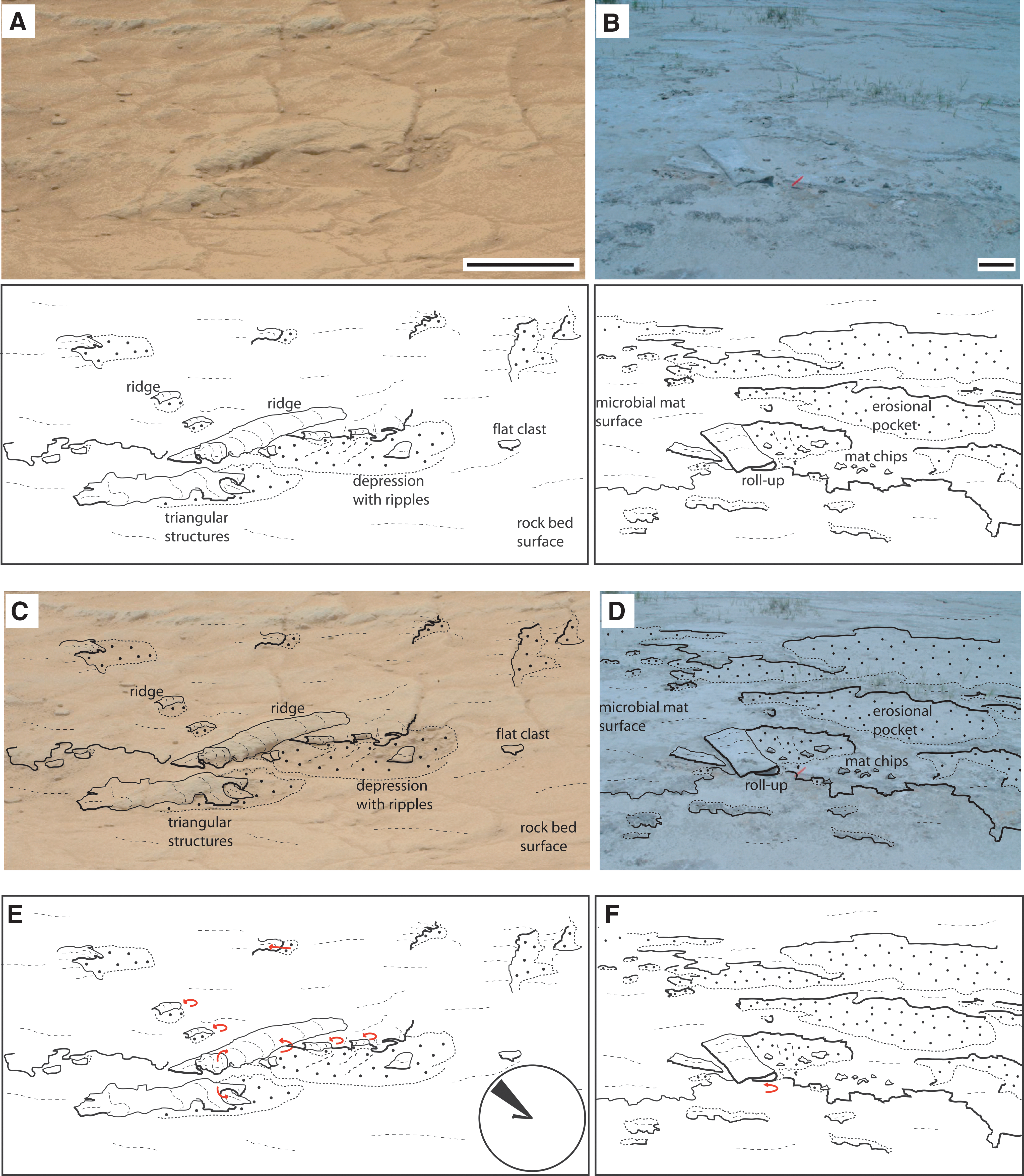
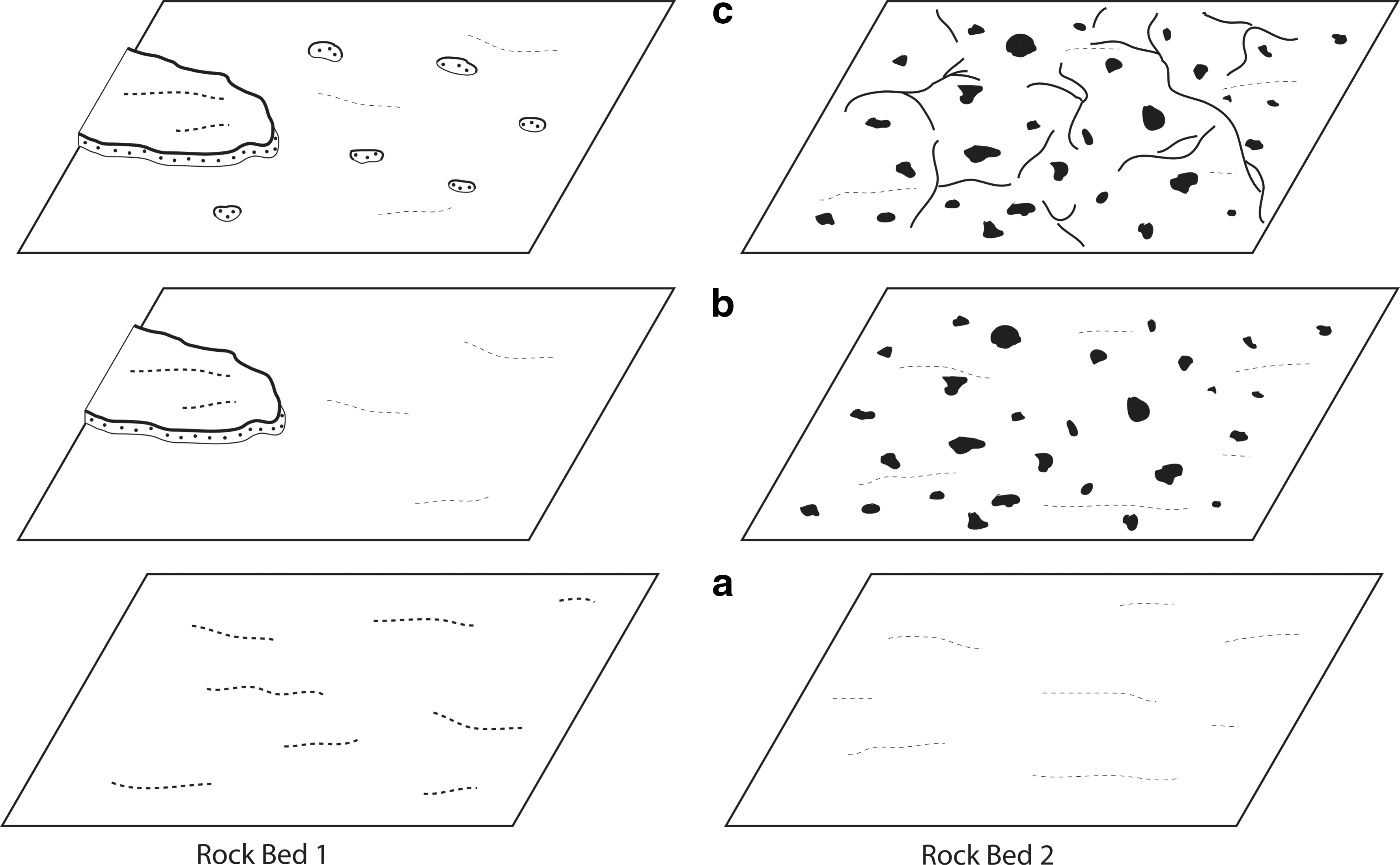
5.1. Succession recorded on the surface of Rock Bed 1
The sedimentary structures preserved on Rock Bed 1 are consistent with the establishment and subsequent decomposition of microbial mats that biostabilized sandy sediments. Such a succession would comprise three stages as illustrated in the schematic drawings shown in the left-hand column of Fig. 8a–8c as follows: Stage a: Epibenthic microbial mats colonize and become established on the sedimentary surface and biostabilize the sand. Stage b: Noncontiguous and isolated microbial mats are eroded away together with the sediment beneath them, which would produce an eroded sedimentary surface that is lower than isolated platforms that remain intact. In the schematic drawings, only one erosional remnant remains, covered by the first generation of microbial mats. Stage c: The lower sedimentary surface is overgrown by subsequent growth of a new generation of microbial mats, though after some time this second generation of microbial mat is also affected by erosion, and small erosional pockets form on the bedding plane.
Successions of microbial mat development and decomposition that are hypothesized to be recorded by the MISS associations of Rock Bed 1 and Rock Bed 2 in the <3.7 Ga Gillespie Lake Member, Mars. The successions are divided into three steps (a, b, and c), as described in the text. Sketches are not drawn to scale.
5.2. Succession recorded on the surface of Rock Bed 2
The surface of Rock Bed 2 shown in the schematic drawings in the right-hand column of Fig. 8a–8c includes a set of MISS that also record three additional stages of development and decomposition of microbial mats. The environmental setting, however, would have been different, as follows: Stage a: Once microbial mats were established, they would, over time, increase in thickness and cover the entire sedimentary surface. As the mat would have been cohesive and contiguous, intra-sedimentary gases could not escape upward and be released at the surface. Instead, they would accumulate beneath the microbial mat. Stage b: An increase in the gas pressure beneath the mat would cause gas domes to form; gas would eventually break through to the surface by bursting through the mat, leaving relicts of gas domes visible as holes in the mat. Stage c: The microbial mat would be subject to a longer time period of subaerial exposure, during which time desiccation cracks would have formed. Some of the early cracks would have “healed” when water temporarily flooded the surface and the microbial mat reestablished growth on top of the early cracks. However, once the water level dropped for an extended period of time, the microbial mat would have desiccated and left only the next generation of desiccation cracks to be preserved.
6. Lithofacies of the Gillespie Lake Member
A panoramic view of a Gillespie Lake Member outcrop higher in the stratigraphic section shows rocks exposed along a very gentle slope (Fig. 9). The rocky surface was dissected by decimeter-scale channels that defined elevated and isolated meter-sized fragments of the outcrop. The elevated fragments display three types of morphologies and are distinguished here as facies: (i) Facies 1—planar surfaces (“plateaus”) that appear in the Mastcam photographs as having a light brown color; (ii) Facies 2—slightly irregular though overall planar plateaus that appear in the images to be gray in color (note that the plateaus of Facies 2 are morphologically higher than those of Facies 1); and (iii) Facies 3—round-tipped, conical shaped elevations (“knobs”) that are dark gray in color.
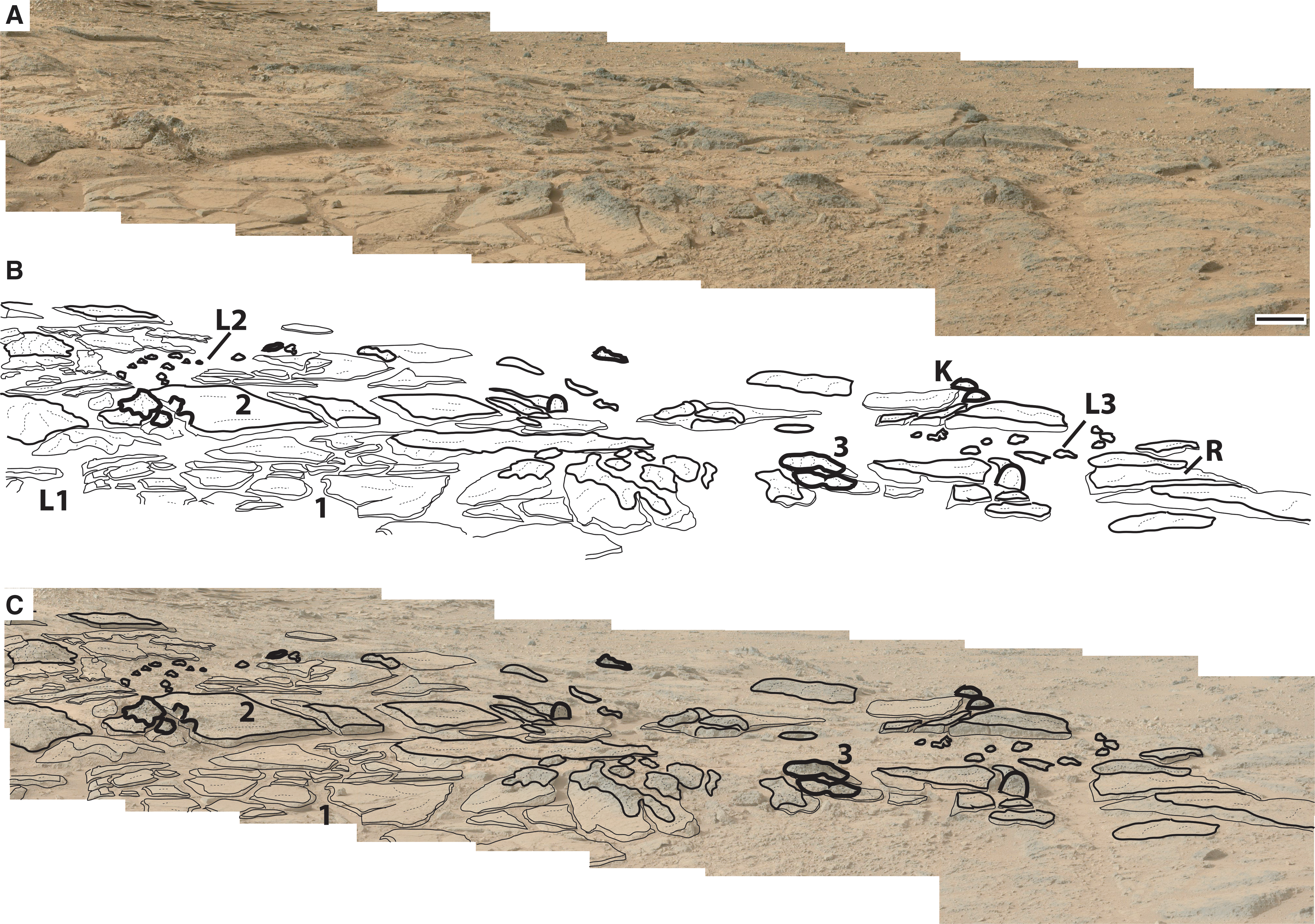
Panoramic view (“stitched” Curiosity rover Mastcam photographs 0306ML0012670000106580E01_DXXX to 0306ML0012670170106597E01_DXXX and 0306MR001267000020-3930E01_DXXX to 0306MR00126701-70203947E01_DXXX) of an outcrop of the <3.7 Ga Gillespie Lake Member, Mars (
The geomorphology of the surface of the outcrop shown in the Mastcam panorama of Fig. 9 includes three flat depressions (marked L1, L2, and L3) surrounded by gentle rims. Facies 1 forms the bottom of the depressions, each of which is surrounded by the flat-topped plateaus (R) of Facies 2. Facies 3 constitutes the highest points (K) of the geomorphological relief and contributes to the positive topography of the rims around the depressions. Small knobs of Facies 3 seem to occur in the depressions located in the upper left and upper right corners of the panorama shown in Fig. 9; however, it is unclear from the images whether the small knobs are in situ or allochthonous pieces of rock. Because the knobs are restricted to the depressions, the assumption here is that they are in situ.
7. Comparison of Martian and Terrestrial (Carbla Point, Western Australia) Lithofacies
7.1. Facies 1
7.1.1. Description
Facies 1, as shown in the Mastcam photographs in Fig. 10 (magnified in Supplementary Fig. S17), is characterized by plateaus with planar surfaces as high as ca. 15 cm. The individual plateaus have triangular, rectangular to polygonal shapes with straight outlines. The plateaus are separated from each other by ca.10–25 cm wide channels. The channels are straight and curve or bend around polygons. Facies 1 is restricted to flat depressions in the outcrop (Fig. 9).
Comparison of flat-topped plateaus that are separated by channels, visible in Curiosity rover Mastcam photo 0306ML0012670150106595E01_DXXX of the <3.7 Ga Gillespie Lake Member, Mars (
The macroscopic morphological characteristics of the slopes of the plateaus of Facies 1 are documented in Fig. 10A. The surface of the plateau again appears to be irregularly structured. The slope on the right-hand side of the plateau, positioned in the center of the Mastcam photograph shown in Fig. 10A, has an angle of about 30° to the horizon as defined by the base of the channel. The slope exposes a stack of horizontal laminae that comprise the elevated plateau. A close-up view of the slope shown in Fig. 11A documents lobes and triangular structures that define the edges of individual laminae that are exposed along the slope. The laminae edges point downward and form small centimeter-scale cavities characterized by irregular lensoidal shapes.

Close-up of Curiosity rover Mastcam photograph 308ML0012740020106667E01_DXXX-br2 shows a plateau of Facies 1 in the <3.7 Ga Gillespie Lake Member, Mars (
7.1.2. Interpretation
The triangular-shaped, rectangular-shaped, and polygonal-shaped plateaus are interpreted here as evidence consistent with the presence of lithified erosional remnants of sediment-stabilizing microbial mats. In at least one example, the channel slopes show macroscopic morphological characteristics consistent with the types of features (i.e., mat fringes and “draped” slopes—see below) that occur when a channel cuts through a continuous and laterally cohesive microbial mat layer (Supplementary Fig. S16).
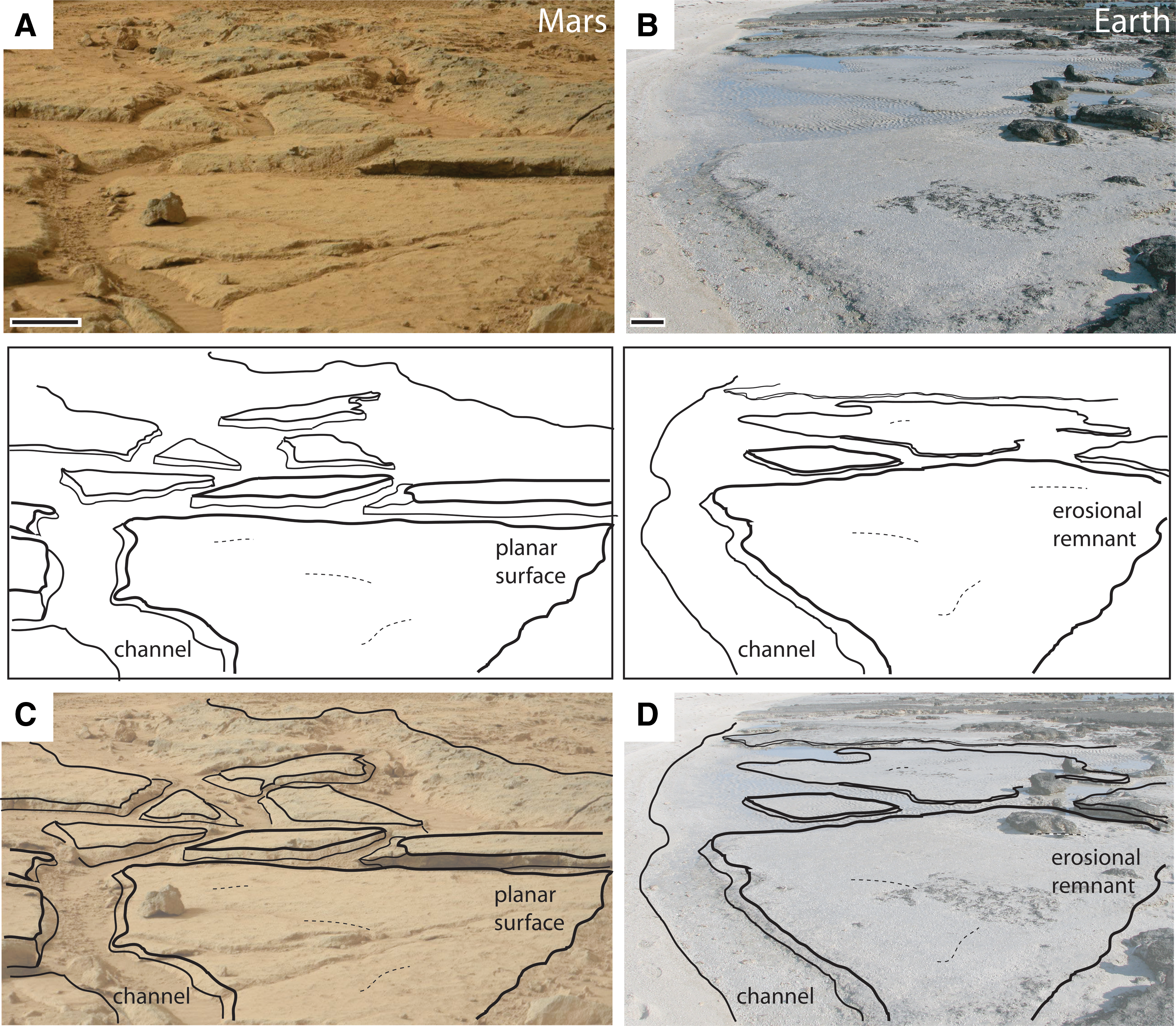
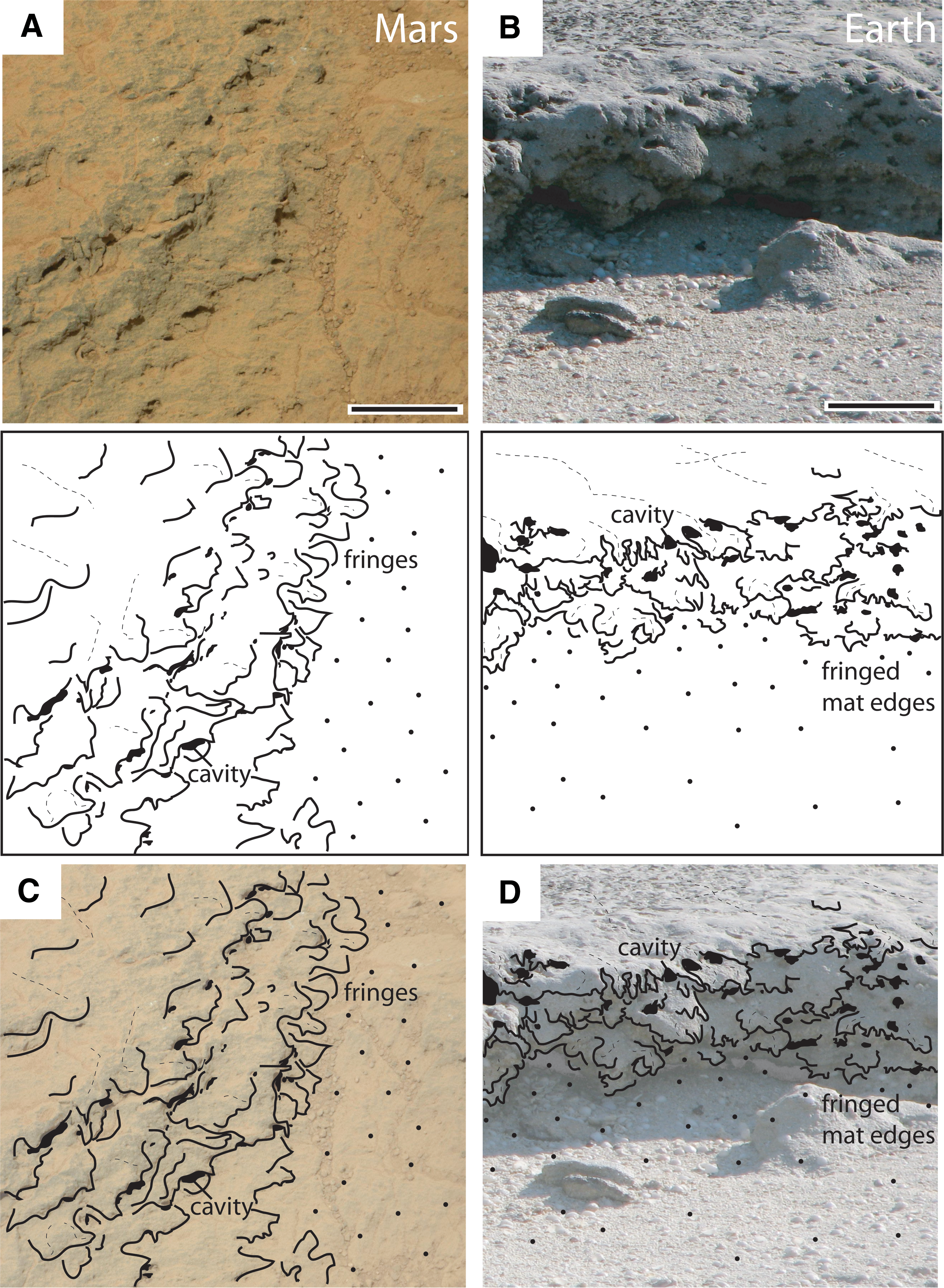
An environmental setting on Earth that has similar macroscale sedimentary surface morphologies and spatial associations of the features interpreted from the Mastcam photographs shown in Fig. 10A as being consistent with life occurs at the modern coastal site Carbla Point, Western Australia (Fig. 10B). Here, a microbial mat–stabilized sedimentary surface was disintegrated by narrow, 30–90 cm wide channels into polygonal-shaped erosional remnants (elevated plateaus) of ca. 1–9 m2 sizes. The erosional remnant is colonized by a type of benthic, laterally continuous microbial mat called a “smooth mat” (e.g., Jahnert and Collins, 2013). The channels are straight to curved and slightly bent and intersect one another at oblique angles. As is the case for the channels in Facies 1 on Mars (described above), the bottoms of the terrestrial channels are even. The microbial mat atop the erosional remnants “drapes” the slopes of the channels; this microbial mat extends down along the slope face and allows steep slopes to develop along the edges of the channels. Without the microbial mat layer drapes, the slope sediments would be composed only of loose sand. Loose sand, however, would not form steep slopes like those observed in the photographs, especially during the times of water recess, which would be followed by subaerial exposure and desiccation of the deposits. The surfaces of the erosional remnants at Carbla Point may appear irregularly crinkled where a patch of another type of microbial mat remained. Small scours, a few centimeters wide, were formed by currents during higher water levels.
The terrestrial features of the erosional remnants at Carbla Point, as shown in Fig. 11B, provide a modern analog setting consistent with the macroscale morphological characteristics and spatial associations of the laminae that crop out along the slope of the plateau on Mars shown in the Mastcam photograph in Fig. 11A. The erosion that produces the “cliff” that defines the erosional remnant reveals the laminated internal stratigraphic buildup of a succession of laminae that consist of former generations of microbial mats. During periods after microbial mat growth was interrupted by the deposition of sediment, the microbial mats reestablished themselves and grew one layer after the other, over time forming a vertical stack of laminae known as a biolaminite. The similarity in the appearance of the biolaminite cropping out along this cliff at Carbla Point (Fig. 11B) with the laminae cropping out along the slope of the plateau in the Gillespie Lake Member on Mars (Fig. 11A) is consistent with a similar genesis. This hypothesis is supported by the comparative Mars-Earth set of images shown in Fig. 12; both sets of images display a similar pattern of lobes and triangular-shaped fringes that, in the terrestrial setting, were produced by the erosion of microbial mats, the relicts of which define the macroscale morphology along the cliff edge and slope face of the erosional remnant. Note in particular that, in the terrestrial example, the laminae of the biolaminite also produce centimeter-scale lensoid-shaped cavities because the mat edges hang downward like the frayed edges of a drape.
Close-up of Curiosity rover Mastcam photograph 0308MR0012730440204010E01_DXXX-br2 shows a plateau of Facies 1 in the <3.7 Ga Gillespie Lake Member, Mars (
7.2. Facies 2
7.2.1. Description
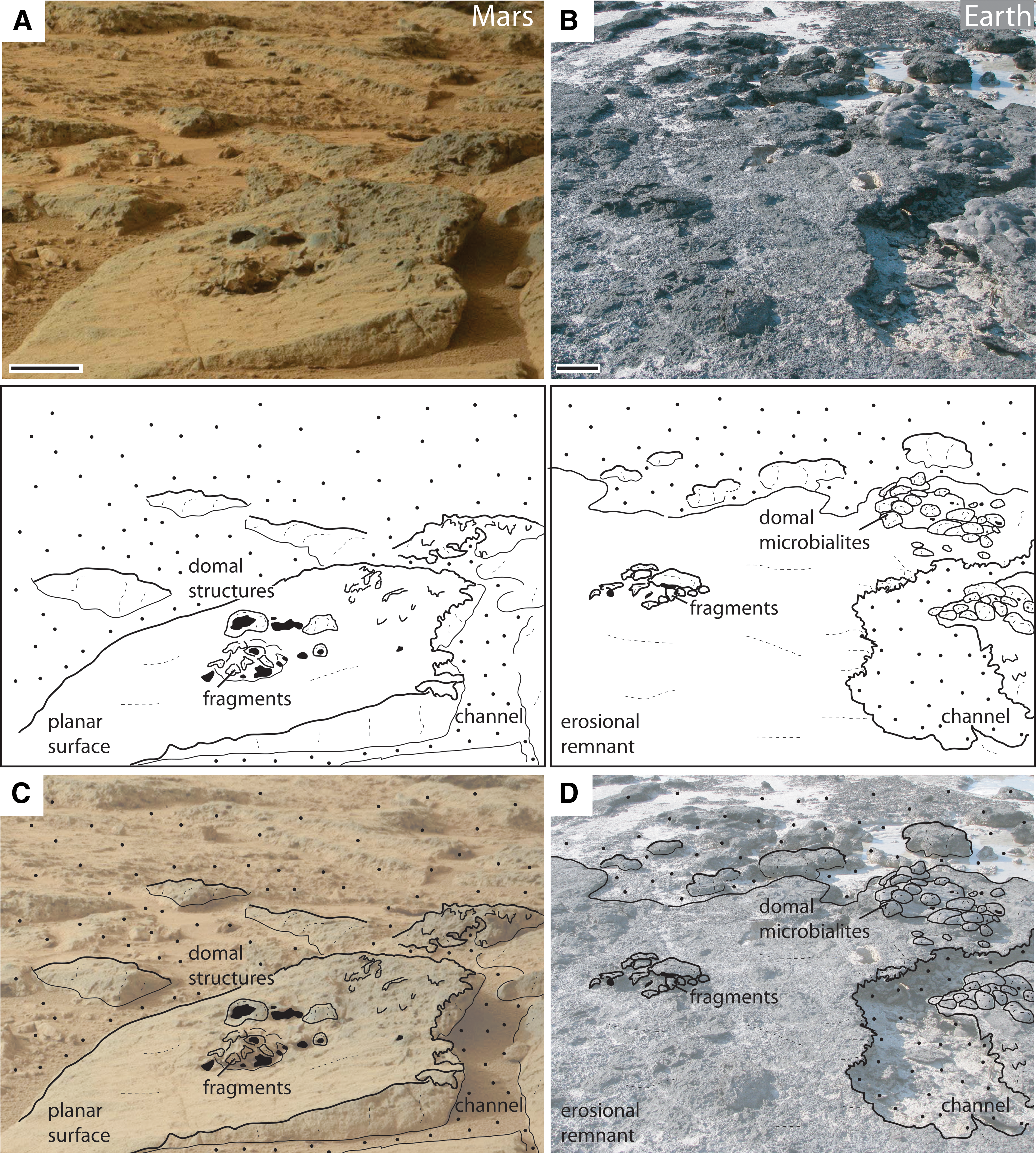
Facies 2, as shown in the Mastcam photograph of Fig. 13A, is characterized by plateaus that look similar in appearance to those of Facies 1 (e.g., Fig. 10A). However, the Facies 2 plateaus are morphologically higher, up to 25 cm from the horizon, and the top surfaces of many of the Facies 2 plateaus are not planar but, instead, are slightly domed and contain small low-relief piles of fragments. Centimeter-scale flat fragments are also distributed at random on some of the plateau surfaces. The surfaces of the Facies 2 plateaus are also rougher than those of Facies 1. The Facies 2 rock surfaces display several caverns of different sizes and shapes. These caverns occur predominantly in association with the fragment piles. As revealed in the Mastcam photograph shown in Fig. 13A and 13C, domal structures (<10 cm wide and up to ca. 5 cm high) and small, irregularly curve-shaped depressions occur atop the surfaces of the Facies 2 plateaus. The slopes of the Facies 2 plateaus are quite steep, and the upper edges of some slopes have a fringe-like irregularity. As shown in Fig. 14A, scours occur along the slopes of some plateaus. In the Mastcam photographs, this lithofacies appears gray in color and, as shown in Fig. 9, is restricted to the slightly more elevated rims that surround the flat and shallow depressions shown in the panorama outcrop image of the Gillespie Lake Member.
Curiosity rover Mastcam photograph 0306MR0012670140203944E01_DXXX of a plateau in the <3.7 Ga Gillespie Lake Member, Mars (
Curiosity rover Mastcam photograph 0306MR0012670160203946E01_DXXX of a plateau formed by Facies 2 (illustrated in Fig. 9) of the <3.7 Ga Gillespie Lake Member, Mars (
7.2.2. Interpretation
At Carbla Point, Western Australia, pustular microbial mats form macroscopic surface morphologies that are comparable to those of Facies 2. The occurrence of small dome-shaped structures on the surfaces of the elevated plateaus of Facies 2, as shown in the Mastcam photographs of Fig. 13A and 13C, is consistent with the presence of an ancient microbial community that differed in composition (e.g., Riding, 2000) from the hypothetical mat that would have colonized the surrounding surface. In terrestrial settings, like that shown in Fig. 13B and 13D, piles of mat fragments accumulate on erosional plateaus after they are ripped up due to localized erosion by strong currents. If the angular, flat fragments that are scattered on the elevated plateaus of Facies 2 of the Gillespie Lake Member are shown to be mat relicts, they could have formed as a result of similarly strong currents. Small depressions on the surfaces of terrestrial microbial mats are known to regrow quickly after flooding events cease.
At Carbla Point, Western Australia (Fig. 14B), blocks of biolaminite that were separated from their parent site lie along the base of the cliff of the modern erosional remnant; the blocks rotated in the currents that flowed around and over the erosional remnants and produced scours along the top edge of the cliffs. Such a situation might be recorded in the Gillespie Lake Member on Mars as well, where round-shaped, rimmed scours occur along the edge of a plateau (Fig. 14A).
7.3. Facies 3
7.3.1. Description
Facies 3 of the Gillespie Lake Member outcrop, the distribution of which is shown in the panorama of the outcrop in Fig. 9 and viewed in a close-up image in Fig. 15, is characterized by cone-shaped elevations (knobs) that are morphologically higher than the plateaus of Facies 1 and 2. The color of the Facies 3 rocks appears in the Mastcam photographs as dark gray. This facies includes caverns that appear to be slightly larger (diameter up to ca. 5 cm) than those of Facies 1 and 2.
Curiosity rover Mastcam photograph 0306MR0012670170203947E01_DXX of knob-shaped Facies 3 structures in the <3.7 Ga Gillespie Lake Member, Mars (
Facies 3 occurs as a capping unit that forms the morphologically highest level at the outcrop area. An example that illustrates the primary macroscopic structures of this facies is marked number 3 in Fig. 9 and shown in the close-up Mastcam photograph in Fig. 15A; these knobs are characterized by pointy, yet rounded, summits and are often grouped together on the plateau surfaces. Several small knobs (a few cm high) occur in the two shallow depressions visible in the background of the outcrop area in Fig. 9. These appear to be situated directly on Facies 1 plateaus that constitute the floor of the shallow depressions.
7.3.2. Interpretation
The environmental setting and macroscopic morphological characteristics of the cone-shaped terrestrial structures at Carbla Point, Western Australia, provide a possible analogue for the distinctive knobby structures of Facies 3 of the Gillespie Member on Mars. The cone-shaped terrestrial structures at Carbla Point document the former presence of thick pustular microbial mats that have, in places, a cavernous appearance because they were partially eroded away (Fig. 15). Interestingly, the cone-shaped structures characteristic of ancient Facies 3 on Mars also display a cavernous appearance, though whether it is due to differential weathering resistance of the rock or is the result of porosity differences of the structure having formed in the presence of a porous microbial mat on Mars will require more study.
8. Possible Paleoenvironmental Setting of the Gillespie Lake Member
If we assume for the following discussion that the martian sedimentary structures at the locale shown in the panorama of the Gillespie Lake Member (Fig. 9) are indeed of biological origin, Facies 1–3 can then be interpreted as a record of a succession of growth and subsequent erosive destruction of thick microbial mats in a flood plain setting. A hypothetical paleoenvironment at this locale on Mars that is consistent with the spatial associations and temporal succession of rock structures identified at Rock Beds 1 and 2 is as follows. Stage 1: establishment of three individual pools within a fluvial, meandering system on a flood plain. If life existed on Mars at that time, it is likely that it would not have taken long for it to colonize the entire submerged floor of the shallow (a few cm or dm deep) pools. Stage 2: the formation of a larger, though very shallow, lake across the entire fluvial flood plain, a process that occurred slow enough to retain the primary structures, such as the elevated platforms, the shallow depressions, and deeper pools. Any potential microbial mat populations would have colonized the now inundated areas as well. Stage 3: the water level in the lake dropped, and the lake emptied over time. The water currents in this newly established drainage system had a higher energy and cut deep into the microbial mats, which produced the narrow channels. Stage 4: the local climate changed, and the entire area fell dry, though many of the distinctive and partly lithified macroscopic morphological surfaces were preserved (e.g., the elevated plateaus, clasts and roll-ups, smooth and pointy knobs, different sets of flooding/drainage channels, desiccation cracks, and mat fringes along the channel slopes).
Without any evidence for life on Mars, reconstructing microbial ecosystems on the Red Planet (and how they might have changed temporally) is pure speculation. It is worth noting, however, that microbial biofilms and often laminated mats on Earth develop on nearly every solid substrate exposed periodically to water (Stoodley et al., 2002). Biofilms also colonize a great variety of substrates composed of loose particles. When hydrodynamic conditions are favorable, these biofilms can develop into thick microbial mats, regardless of the petrological composition and physicochemical properties of the sediments on which benthic microbial communities grow. Biofilm and mat growth on loose sediments is controlled by the roughness of the surface of the individual grains and the duration of hydraulic quiescence (e.g., Paterson et al., 1994; Gjaltema et al., 1997; Lopes et al., 2000; “hydraulic window for microbial mat development” sensu Noffke, 2010). Grains of quartz or basalt composition are excellent substrates that enable rapid colonization by benthic prokaryotes on Earth (e.g., Callac et al., 2013). Basalt-rich sands on Mars could also have provided a suitable substrate for the formation of microbial mats.
9. Discussion of Alternative Abiotic Origins for Sedimentary Structures in the <3.7 Ga Gillespie Lake Member, Mars
While the similarity in macroscale morphology, spatial associations, and temporal successions of the terrestrial and martian sedimentary structures is consistent with the hypothesis that they were generated in similar ways, the structures identified in the Gillespie Lake Member in this study may have been produced via a different process than that of MISS on Earth; it is important to consider that the martian structures may simply represent products of abiotic processes.
Pits can be wind-formed ventifacts and the consequence of saltation of rock beds by pebbles due to the action of strong winds on Mars (e.g., Thomas et al., 2005). Dissolution of primary phases and secondary precipitates could initiate cavernous weathering on rock surfaces, as could the dissolution of diagenetic concretionary nodules and mudstone clasts (Grotzinger et al., 2014). Cavernous features are produced in rocks that have pockets of lower resistance against erosion; a similar process can lead to the production of tafonis (sensu Blackwelder, 1929). Weathering on Mars is also attributed with forming honeycomb patterns (Rodriguez-Navarro, 1998). Though honeycomb and cavernous weathering features can appear as honeycomb-like patterns on weathered rock surfaces, the pits that resemble burst gas domes display a polygonal pattern.
Flat clasts, fragments, and “flakes” of rock can be splintered off weathered rock surfaces as a result of insolation (Thomas et al., 2005; Viles et al., 2010; e.g., the introduction into Mars sedimentology in the volume by Grotzinger and Milliken, 2012); frost weathering and salt weathering, the latter of which on Mars is attributed with producing angular fragments (Jagoutz, 2006); and abrasion due to saltation (Grotzinger et al., 2014). The clasts derived from such processes, however, are not likely to be as flat and wide as those observed at the sites of the Gillespie Lake Member sandstones. It is also worth noting that, unlike the visually distinct pebbles captured in Mastcam photographs at the study sites, the flat clasts associated with the elevated platforms appear diffuse in the Mastcam photographs, interpreted here as evidence that they formed syndepositionally with their parent deposit.
The crack patterns observed at the study sites are polygonal in shape. Polygonal crack patterns in playas on Earth are the result of the desiccation of clay-rich muds (Adams and Sada, 2014) and do not form when loose unconsolidated sands are desiccated unless those sands are held together cohesively by microbial mats (Schieber et al., 2007). The precipitation of minerals, such as gypsum, by circulating intra-sedimentary water could also have contributed to the formation of cracks on Mars (Chavdarian and Sumner, 2006), though such fluids would have followed preexisting fractures in the rock and not have formed the fractures/cracks. Chan et al. (2008) describe cracks caused by weathering processes on Mars. Polygonal patterns in permafrost areas on Mars (e.g., El-Maarry et al., 2014; Soare et al., 2014) are typically larger (≥meters) than those in the Gillespie Lake Member sandstones. Syneresis cracks (formed when loose sediments are converted to rock) are, by definition, short, laterally discontinuous, and spindle-shaped when viewed in cross section in sandstones. More so, on Earth they occur at the base of sandstone beds and are characterized by positive “epi-relief,” inherited from cracks that were preserved in mud layers that lie below, but in contact with, the basal sandstone beds (e.g., Burst, 1965). The expansion of rock due to the removal of overburden sequences (i.e., rocks that were deposited on top of the Gillespie Lake Member sandstones) by erosion could also produce cracks. However, the cracks at the Mars study sites (some of which appear on the surface to be “healed”) do not continue vertically downward into the rock bed itself but are surface features. Cracks on Mars could also have been caused by a process known as “dirt-cracking” (Ollier, 1965; Thomas et al., 2005), which is common in deserts. Such cracks, however, tend to be straight, not bent, and they do not display two parallel positive-relief rims or ever appear as having been “healed.” Secondary diagenetic processes could produce cracks as well; one might think of stylolite formation due to loading pressure. However, stylolites are products in carbonate rocks (“limestone”) where stress causes clay minerals to assemble along pressure lines in the rock. Such stylolites do not occur in basalt sands, which are composed of a mineral assemblage that is much more resistant to pressure than clay or limestone.
The roll-up-type structures identified on top of the rock bed surfaces on Mars could also have been produced abiotically. Like mat chips, however, the formation of roll-ups in loose sand, even if it was consolidated, would require the presence of a sand grain-binding matrix, such as a microbial mat. Roll-ups do not form in sand that is not colonized by cohesive microbial mats; this is in contrast to “mud curls,” which quite commonly form atop a desiccating sedimentary surface without cohesive mats (Plummer and Gostin, 1981; Adams and Sada, 2014). In their detailed study, Beraldi-Campesi and Garcia-Pichel (2011) showed that roll-up structures in terrestrial settings on Earth are mostly overgrown by benthic cyanobacteria; while these roll-ups are very coherent and withstand weathering for a long time, roll-ups in mud do not remain intact after being subjected to rain. This resistance against erosion increases the preservation potential of mat-induced roll-ups significantly.
Laminae in clastic sediments could also be abiotic in origin. Laminae may rise from currents of very low or very high energy or from sudden slight changes in sediment composition. This would not explain, however, the fringed edges of the laminae that are visible along the slopes of the elevated plateaus in the martian outcrop. The laminae-parallel caverns (e.g., Fig. 12A) are here interpreted as having been formed by the ancient mat laminae of hypothetical biolaminites. Voids can result from a number of abiotic processes: fossil vesicular lava, a pebbly debris flow, or a gas-filled sedimentary sill; or the rock might be sandstone with leached nodular evaporites (cf. Grotzinger et al., 2014). The question remains as to why the caverns are slightly elongated and oriented parallel to the bedding and laminae. Pores typical for pahoehoe lava are irregular in both size and distribution; the pores do not show any relation to laminae, and they are not elongated but more spherical in shape (MacDonald, 1953; his Fig. 2). The same is true for gas-filled sand sills, which rarely show laminations (Hurst et al., 2011). Bedding-parallel and elongated voids may result in certain circumstances, but if so they also include vertically oriented pipes at at least one end (e.g., Lowe, 1975; Ross et al., 2011), a characteristic that was not observed in any of the martian outcrop images. It is worth noting that the caverns in Facies 2 are laminae-bound, whereas in Facies 3 they show no relation to any laminae.
Whereas the morphologies of the individual MISS-like sedimentary structures on Mars might be due entirely to abiotic processes, it remains to be shown how recent weathering processes could have created the temporal sequence of Facies 1–3 and produced the ancient surface relief of the sedimentary structures visible at the Gillespie Lake Member outcrop discussed here. As shown in Supplementary Fig. S17, the similarity in the relief of proceeding, now buried surfaces (1 and 2) with the current exposed rock bed surface suggests that these proceeding surfaces were produced by the same mechanisms. This would exclude recent weathering of the actual rock bed surface as the prime factor responsible for the relief of the exposed outcrop of the Gillespie Lake Member studied. If recent weathering processes on Mars are so similar to weathering that would have taken place up to 3.7 Ga, then this would constitute an extraordinary coincidence. More so, the martian structures are not distributed at random but show a spatial assemblage and temporal change like those of MISS on Earth (Figs. 7 and 8). In terrestrial settings, these associations are the result of microbial mats interacting with, or perturbed by, environmental parameters. If the structures on the rock beds on Mars were exclusively the result of recent martian weathering, then Rock Beds 1 and 2 of the Gillespie Lake Member would display the same structure associations. As discussed in Sections 4 and 5 above, they do not. This similarity of martian and terrestrial associations and the change over time would be another extraordinary coincidence, should their processes of formation be different.
10. Hypothesis
The <3.7 Ga Gillespie Lake Member on Mars records an ancient playa lake system. The rocks display a variety of sedimentary structures that have equivalent macroscopic morphology to terrestrial MISS that formed in similar environmental settings. The martian sedimentary structures are not distributed at random but form distinct associations and temporal successions related to specific facies zones. The same facies-related structure associations and their changes over time are formed by MISS on Earth. If the martian structures are found to be fossil MISS, they will mirror an ecological change of ancient microbial mats in a regressive playa lake system.
Based on the observations made in Curiosity's Mastcam photographs of three main characteristics of the Gillespie Lake Member outcrop (i.e., the macroscopic morphology, distinct spatial associations in different facies, and a temporal change in the stratigraphic succession), this study has led to the following hypothesis: The sedimentary structures in the <3.7 Ga Gillespie Lake Member on Mars are ancient MISS produced by interactions between microbial mats and their environment. This hypothesis is testable and warrants further scrutiny in current and near-term missions to Mars.
11. Strategy for Detecting, Identifying, Confirming, and Differentiating Possible MISS in Current and Future Mars Missions
To verify this hypothesis, detailed analyses of candidate structures in the Gillespie Lake Member on Mars must be conducted. The strategy by which to search for MISS (on Earth as well as on other planets) is divided into four steps: detection, identification, confirmation, and differentiation. These steps were developed in order to cover the criteria of biogenicity of MISS that is required to prove definitively whether a candidate structure is of biological origin (detailed outline in Noffke, 2010). This search requires rover capability and could be conducted during the Curiosity mission as well as a part of any other astrobiology-focused rover mission to Mars.
Detection includes the search for aquatic environments, where microbial mats could have developed and become preserved (Noffke, 2000; Noffke et al., 2002). In doing so, both the ecology of microbial ecosystems and taphonomic factors that would have determined the preservation potential of morphological and chemical biosignatures indicative of MISS must be considered. Suitable ecological environments would have required moderate hydraulic energy. Waves and currents could not have been so strong as to enhance sediment deposition and prevent microbial colonization, nor could they have been so weak as to prevent destruction of developing microbial mats by erosion (“hydraulic window for mat development” sensu Noffke et al., 2002; Noffke, 2010). The preservation of MISS is enhanced by baffling and trapping processes that result in the accumulation of fine clastic particles in benthic microbial mats in detrital sedimentary environments (“taphonomic window of microbial mat preservation” sensu Noffke et al., 2002; Noffke 2010). Clastic rock successions with rock bed thicknesses between 2 and 20 cm that include evidence of structures produced by currents (e.g., ripple marks of less than 12 cm crest-to-crest distance) constitute the most promising host lithologies to search for MISS on Mars.
Detection on Earth is conducted from the outcrop scale to the centimeter scale. MISS on Earth extend laterally across square centimeter- to kilometer-scale dimensions. MISS occur on top of sedimentary rock surfaces (e.g., as erosional remnants and pockets, wrinkle structures, gas domes), but they can also be recognized in vertical sections (e.g., as roll-ups, sinoidal structures). The Mastcam imager of the Curiosity rover, for example, is well suited for such a search. Outcrops suitable for a nested set of images at sequentially higher magnification/resolution that display well-preserved rock strata in vertical section, laterally extensive rock bed surfaces, and minimal loose sediments focus the search strategy for any possible host lithology identified on Mars.
Searching and documenting rock bed surfaces that are not littered by loose sediment (pebbles, sand, ventifacts, etc.) is strongly recommended. Clastic detritus covers exposed surface relief, whereas recent eolian abrasion of rock surfaces exhumes an original sedimentary surface relief and increases visibility of a potential candidate structure. There is no evidence in the geological record on Earth that erosion could produce the (1) sedimentary structures on a rock surface that resemble MISS, (2) spatial associations of MISS, and (3) temporal successions of abiotically produced microbially induced sedimentary-like structures. Detection of microbially induced sedimentary-like structures in an extraterrestrial rock succession that records an aquatic paleoenvironment is facilitated by stratigraphic logging, in centimeter scale if necessary. If a candidate structure is detected, the next step is its identification.
Identification is the comparison of the macroscopic morphology of extraterrestrial candidate structures with that of terrestrial MISS. MISS types are distinct. At the present time, a clear distinction exists between MISS and abiotic structures; MISS morphologies are therefore reliable biosignatures on Earth. However, one must always consider a possible transition between the morphologies of MISS and abiotic structures that may form in similar physical, chemical, and hydrological regimes. Rovers should take photographs of potential MISS at different lighting conditions, such as was done for the terrestrial examples presented in the present study, from all sides to gain an overview of all three dimensions of a structure; one image is insufficient to evaluate geometries and sizes.
Shade caused by light striking a sedimentary surface at a low angle enhances the contrast of features of a surface relief that might otherwise remain undetected (examples in Noffke, 2010). If there is not enough natural illumination, an artificial light source is recommended. Close-up images would assist in identification of structures of centimeter scale such as, for example, mat drapes, wrinkle structures, roll-ups, or mat chips. Documentation of thicknesses of flat clasts (potential mat chips) or of the vertical section of a potential roll-up would be essential. Areas in outcrop that cannot be reached by a rover could be zoomed in on, and additional high-resolution photographs could be taken. If a candidate structure on Mars is of high resemblance to a terrestrial MISS, like the examples shown in this report, the next step would be to confirm its possible biogenicity.
Confirmation is the search for microstructures (microscopic textures) in the candidate structures. Biogenicity criteria for MISS include the presence of small mat-layer-bound grains, oriented grains, and seven other typical MISS textures (Supplementary Fig. S18). Such textures have not yet been investigated for the possible microbially induced sedimentary-like structures described here from the Gillespie Lake Member. Likewise, is it possible that there are certain minerals in the structures that resulted from microbial metabolic activity? On Earth, minerals such as pyrite, chamosite, hematite, and others are typically associated with MISS; on Mars, there could exist, within candidate structures, a very different assemblage of minerals that is clearly divergent from the mineralogy of the surrounding host rocks but could indicate biogenicity of the structures. It is important to note that such mineral associations in microbial mats are not distributed at random; rather, the minerals mirror ancient textures, such as the filaments that form the typical meshwork of microbial mats, or coccoids that assemble as colonial clusters. Investigations of close-up images of polished blocks of martian rock or of thin sections made from those rock samples may reveal the mineralogical composition of such textures (e.g., see terrestrial example shown in Supplementary Fig. S19). Geochemical and mineralogical measurements of the deposits in situ with the use of rover Curiosity's Alpha Particle X-ray Spectrometer (APXS), ChemCam, and especially CheMin (Chemistry and Mineralogy X-ray diffraction and X-ray fluorescence) and in samples analyzed for organic or chemical signatures by the Sample Analysis at Mars (SAM) suite of instruments would be helpful; returned rock samples of possible microbially induced sedimentary-like structures would be ideal.
Differentiation is the comparison of candidate structures with possible abiotic, but morphometrically and chemically similar, structures. While this has been done for terrestrial MISS in abundance, the physical as well as chemical properties of Earth through time are also relatively well understood. To evaluate martian sedimentary structures, however, syndepositional processes, postdepositional diagenetic alteration, and weathering typical for Mars must be taken into consideration. Because much of Mars' early history and the former depositional and diagenetic processes are still unknown, this last step clearly can only be accomplished in the future.
In conclusion, the sedimentary structures in the Gillespie Lake Member, Mars, constitute a promising set of potential biosignatures that compel further analyses by Mars rovers, including future sample return missions from Mars.
Footnotes
Acknowledgments
The author thanks Linda Kah, John Grant, Matt Golombek, John Farley, David Way, Mary Voytek, and Michael Meyer for their interest in MISS as possible biosignatures on Mars and for the Mars rover 2020 landing site discussion. Five anonymous reviewers and the editors Sherry Cady and Norm Sleep provided detailed and helpful comments and are thanked for their endeavor. The study was partially funded by NASA Exobiology, NSF Sedimentary Geology and Paleobiology Programs, and NASA Astrobiology Insitute.
Author Disclosure Statement
No competing financial interests exist.
Abbreviation Used
References
Supplementary Material
Please find the following supplemental material available below.
For Open Access articles published under a Creative Commons License, all supplemental material carries the same license as the article it is associated with.
For non-Open Access articles published, all supplemental material carries a non-exclusive license, and permission requests for re-use of supplemental material or any part of supplemental material shall be sent directly to the copyright owner as specified in the copyright notice associated with the article.