
Abstract
A field expedition in the High Andes/Atacama Desert region revealed two types of flow-produced structures and a unique flow regime. Gullies somewhat smaller than those on Mars (width: 0.2–1 m, depth: 0.2–0.6 m, length: 4–60 m) were observed as mainly erosional structures. The other flow-related feature called infilled valleys showed activity only in specific, spatially discrete areas during the daytime. The active sections were composed of a source depression where liquid H2O was produced from subsurface buried sources, which flowed down and percolated into fine-grained infilling material of the valley. Several such active sections could be present along one valley, separated by inactive ones. Three types of H2O sources fed them: buried snow, surface snow, and ice left behind from the liquid water that had emerged the preceding day. This latter source has not yet been suggested for Mars. Some aspects related to the formation of the gullies and infilled valleys (H2O budget, albedo, erosional processes) may be similar with the formation processes hypothesized for the recurring slope lineae on Mars. The observed diurnal spatially discrete activity of the infilled valleys is related to the interaction of insolation and mass movement of exhumed subsurface snow, which is also believed to exist on Mars. The Ojos del Salado site is unique in that, despite it being located in the hyperarid High Andes/Atacama Desert region, material from rare snowfall events has been protected due to burial by grains transported by strong winds, supporting ephemeral melting in the long term.
1. Introduction
This work aims at characterizing the ephemeral flow features in the high-altitude dry and cold Ojos del Salado region of the High Andes/Atacama Desert region, which were discovered during a field expedition in February of 2018. The hyperarid region (Barrett et al., 2016) provides potential and partial analogs for the analysis of ephemeral liquid water flows on Mars (Heldmann et al., 2010; de Haas, 2016). In this work, the main properties of these flow features and related surface structures are described, in part, to identify the source and flow mechanism of water but also to better understand relevant aspects pertaining to Mars. First, the results obtained to date are summarized with respect to this terrestrial site; in the latter part of this section, the related martian features are considered.
Earlier studies of fluvial and liquid water-related Mars analog research in the High Andes/Atacama Desert region targeted, among other topics, the analysis of kilometer-sized fans as potential analogs for martian fans in the Saheki crater (Morgan et al., 2014), tributaries (Irwin et al., 2010), the role of groundwater flow (Jayne et al., 2016) that produced substantially larger flow discharges during the Pleistocene (Nester et al., 2007), and the presence of brines (Risacher et al., 2003). The formation of liquid water from fog precipitation (CáCeres et al., 2007) and deliquescence (Farris and Davila, 2016; Van Alstyne et al., 2017), which are of astrobiological relevance (Wierzchos et al., 2012; Pal, 2019), have also been studied in the Atacama. However, to our knowledge, a few studies have been published on the possibility of water flow production due to ice melt in the colder (high altitude) regions of the dry Atacama Desert, which is the subject of this work. Typically, snow occurs only in the highest altitude region of the desert and usually only for limited durations. This is similar with what is presumed to occur on Mars.
Most of the fluvial features on Mars formed during the early Noachian era (between around 4.1 and 3.7 Ga) and are present today as network-like valleys (Carr and Clow, 1981; Baker et al., 1992; Carr, 1996; Hargitai et al., 2012; Hynek et al., 2010; Steinmann, 2019). These features likely represent the early wet period, when substantial fluvial sediment transport (Hynek and Philips, 2001), standing water bodies (Fassett and Head, 2008a, 2008b), and wet weathering produced phyllosilicates (Ehlmann et al., 2011), which provide constraints for interpretations of the ancient climate. However, despite these observations, it is not well known how warm the early period was or whether it was only occasionally wet and generally cold (Palumbo et al., 2018), as climate models are problematic with regard to the reconstruction of a warm early Mars (Wordsworth, 2016). Fluvial activity in the valley networks continued into the Hesperian (Mangold and Ansan, 2006; Bouley et al., 2009, 2010; Hynek et al., 2010; Baker et al., 2015).
Dense networks of fluvial valleys also formed on Amazonian-age surfaces of some martian volcanoes, such as Alba Patera and Hecates Tholis (Gulick and Baker, 1989, 1990; Gulick, 2001). Other much younger, smaller, and more pristine valleys, called Fresh Shallow Valleys, formed primarily in the mid-latitudes during the Amazonian (e.g., Hobley et al., 2014; Hargitai et al., 2017, 2018) and are believed to be formed by ice or snowmelt processes. Subsequent with the Noachian/Hesperian boundary and due to global cooling, liquid water on the surface became rare (Mangold et al., 2012) and quickly froze if it emerged (Carr and Head, 2003). Water occurred occasionally, due to tectonic and volcanic activity (Rodriguez et al., 2015), and produced large outflow channels (Carr, 1979). Also, internal heat could melt ice locally (Jakosky and Carr, 1985), though liquid water at the surface became subsequently rarer as time passed by, although long-term episodic activities occurred regionally (Irwin et al., 2015).
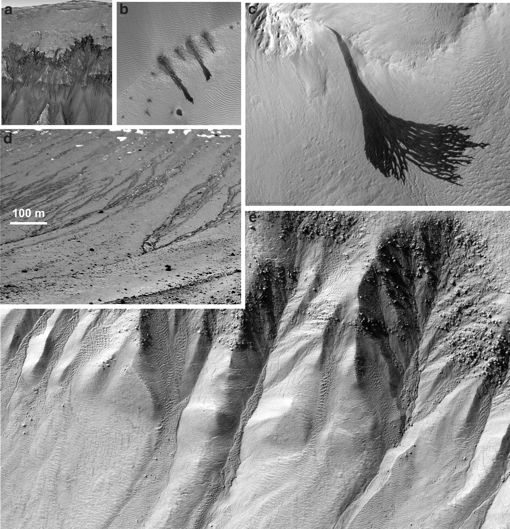
Aside from these old surface features related to water on Mars (Fasset and Head, 2008b; Hargitai et al., 2018), more recent and potential ephemeral liquid flow related features on Mars have been identified that are currently, or were recently, active, which include the recurring slope lineae (RSL) (e.g., McEwen et al., 2011), low latitude slope streaks occasionally with anastomosing morphology (Miyamoto et al., 2004b; Kreslavsky and Head, 2007), and flow-like features emanating from Dark Dune Spots (Kereszturi et al., 2010) for which there are no water alternatives for their origin (Hansen et al., 2013). Comparisons of these recent or currently active features on Mars are presented in Tables 1 and 2 (Kereszturi et al., 2012). In some cases, seasonal changes were observed in gullies as well (Pasquon et al., 2016, 2019), where wet-thaw processes in the shallow subsurface might contribute to the production of observed morphology (Jouannic et al., 2015).
Spatial Characteristics of the Flow-Like Structures on Mars
DDS, Dark Dune Spot; RSL, recurring slope lineae.
Physical Parameters of the Flow-Like Features on Mars
Morphological (erosional and depositional) surface signatures of flows from the last several millions of years are found on Mars in the form of gullies (Malin and Edgett, 2000; Schorghofer et al., 2002; Christensen, 2003; Malin et al., 2006) at the latitude-dependent mantle (LDM) or layer that forms a water
The relevance of the observations from Atacama is that, under such desert conditions on Earth, buried solid H2O primarily remains and supports occasional runoff events. Also, an LDM might occur in similar settings: solid H2O below some regolith. Despite the fact that the flow often emerges from poorly compacted snow, there are firn-like buried structures at the martian analog site studied (see Figs. 5 and 7 for a general description of the target region in this special issue Kereszturi et al., 2020), and the method of formation and the decay of buried solid H2O in general might contribute as well to our understanding of melting associated with LDM on Mars. Thus, LDM could be considered a process and not a morphological analogue. There are also Earth-based analogues for the potentially active flow features on Mars (Conway et al., 2018), including water tracks in Taylor Valley Antarctica (Levy et al., 2011). It can be argued that these features resemble RSLs (Levy, 2012) and gully-like features at Devon Island (Lee et al., 2002), East-Antarctica (Hauber et al., 2018), Himalaya (Sinha et al., 2018), and Svalbard (Hauber et al., 2011). In these regions, snow accumulation, melting, and ephemeral runoff produce features that resemble those of other cold terrains. See Fig. 1 for example images of these candidate water flow-related features on Mars and Earth.
Comparison of RSLs
There are other alternative models for their origin besides liquid water flow, including dry granular flow (Cedillo-Flores et al., 2011), CO2 gas fluidization-driven movement (Cedillo-Flores et al., 2011), sliding and sublimating blocks of CO2 ice on dune slopes (Diniega et al., 2013; Pilorget and Forget, 2016), and liquid water breakout (Musselwhite et al., 2001). Even with water produced runoff, a subsurface source of the liquid is also an alternative possibility in addition to surface ice melting (Parsons and Nimmo, 2010). Also, the flow could be highly sediment rich with a small amount of liquid water lubricating the grains (Kolb et al., 2010). Boiling water under the low martian atmospheric pressure is also a possibility (Herny et al., 2018), whereas subsequent dry mass wasting could enlarge earlier formed channels on Mars, an interpretation based on the study of Earth analogs (Hobbs et al., 2014). CO2 sublimation might also contribute toward making the formation complex (Conway et al., 2016). Seasonal changes related to frost formation and sublimation were observed by Nunez et al. (2013), and CO2 could also contribute to their formation (Raack et al., 2012). In general, it is also possible that gullies with substantially different morphologies were caused by other processes (Baker et al., 2015; Levy, 2015; Gulick et al., 2019).
Although the origin of these current or very recent flow features is not clear, their size (100–1000 m scale) and the expected discharge of the flow events (on the order of m3/s, Miyamoto et al., 2004b) that produced them may be in close proximity to these structures, which were observed on Earth under cold and dry climate conditions and resemble martian gullies and slope streak features. At the Ojos del Salado region, groups of similar Mars relevant water flow-produced features were observed and presented in this work.
Despite the morphological similarity of the martian features to those that are water flow produced, there is debate as to the physical background of how liquid water could emerge on the red planet under current conditions. Certain model calculations can predict that liquid water may currently exist (Clow, 1987; Haberle et al., 2001; Hecht, 2002), and some of the surface features listed earlier favor the ephemeral existence of a liquid phase (Brass, 1980; Mellon and Phillips, 2001; Knauth and Burt, 2002; Kuznetz and Gan, 2002; Kossacki and Markiewicz, 2004; Motazedian, 2004; Kereszturi et al., 2009; Szynkiewicz et al., 2009; McEwen et al., 2014). The formation of liquids on Mars by deliquescence (Martin-Torres et al., 2015; Pál and Kereszturi, 2017) and as macroscopic brines (Möhlmann, 2004; Kossacki and Markiewicz, 2008; Martínez and Renno, 2013) are an important and realistic possibility, as suggested by observations at the Phoenix landing site (Kossacki and Markiewicz, 2004; Chevrier et al., 2009; Hecht et al., 2009a, 2009b; Renno et al., 2009). In this work, important and relevant Mars analog observations are presented where the dryness and cold conditions in general met with strong solar insolation, and these might support the formation of ephemeral liquid, serving possible useful analogs to better understand martian processes.
2. Methods
The observations and field survey were realized between 19 and 26 of February 2018 over a 5-km distance around the Atacama base camp, on the slope of the Ojos del Salado volcano around 5200 m in elevation. During the field work, photo imaging, excavation by spade, sample collection, and measurement of distances and sizes of various structures were completed.
Because of the unusual field site and special observed features, it is important to mention relevant nomenclature. The term “infilled valley” is used to refer to elongated, topographically downward oriented depressions, which are several meters wide, 25–280 m long, the depressions of which are filled with sand (1.0–0.2 mm grains) and silt (0.1–0.004 mm grains) with signatures of erosion and deposition. The term “erosional gully” is used to refer to smaller structures that may occur as side branches of the infilled valleys or occur without them as well. They are from 1 dm to 1 m wide and several meters in length, and they show primarily or solely erosional features that include collapsed and occasionally steep walls (rarely near-vertical side walls that are a decimeter high). The shape of the cross-sectional profile of these structures is variable but most often exhibits a V or U shape, and no fine granular sediment accumulation was found in their depressions. Compared with erosional gullies, the side walls of the infilled valleys mentioned earlier are less steep. To distinguish the structures called gullies on Mars from those on Earth, we use the terms “martian gullies” and “terrestrial gullies” throughout this work.
During field survey 3, infilled valleys were analyzed in detail for the sectioned activity (located at −27.061°S, −68.546°W), where 4–7 such active sites were present along each valley, separated by 30–80 m distance from each other along the valleys' longitudinal axis. Six erosional gullies were analyzed in detail, whereas around three dozen similar structures were visited as well. At the sites, the detailed field survey included image recording, field analysis of granular material, and examination of the subsurface by digging with the spade mainly to identify buried snow. However, at several locations, excavation at the outcrop was only partly successful and had to be attempted two or three times by selecting new locations close to the failed ones, as a result of hard ice cement in the subsurface and the occurrence of centimeter- to decimeter-sized rocks below the surface. The field work was performed 2 days after a local snowstorm, resulting in remnant snow in locations shielded against strong insolation and wind-supported sublimation or rare melting. The field work and monitoring of targets were done over 8 days. During the measurement of physical sizes, we used a measuring tape for smaller features of less than a few meters and GPS-based coordinates and elevations for features above ∼10 m.
3. Results
Two types of fluvial channels were characterized based on their morphology: The smaller ones, referred to as erosional gullies (width: 0.2–1 m, depth: 0.2–0.6 m, length: 4–60 m) without fine-grained fill, exhibited a moderately integrated network (Fig. 2c) with many parallel terrestrial gullies. The other group was composed of larger valleys, referred to as infilled valleys (width: 2–26 m, depth: 0.5–3 m, length: 25–280 m), with smooth fine-grained plain deposits between the rough debris composed sidewalls. The reaches in this second group exhibited a somewhat higher integration, where certain reaches were coalesced and provided higher hierarchical integration (see the upper part of Fig. 2d, where the bright aeolian deposit resulted in brighter valleys). Both structure types were located not on lava but on the debris-covered slope of the volcano where redistribution of debris occasionally occurs by way of wind and mass movements.
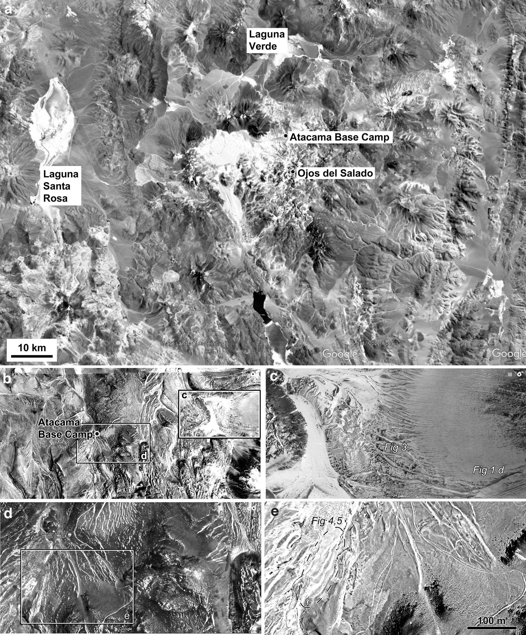
Overview map of the analyzed sites.
Example images of terrestrial erosional gullies recorded between 10 and 12 local solar time. Trenches
Sample images showing the sedimentary settings where the terrestrial gullies cut into the surrounding terrain. Mixed-sized volcanic debris
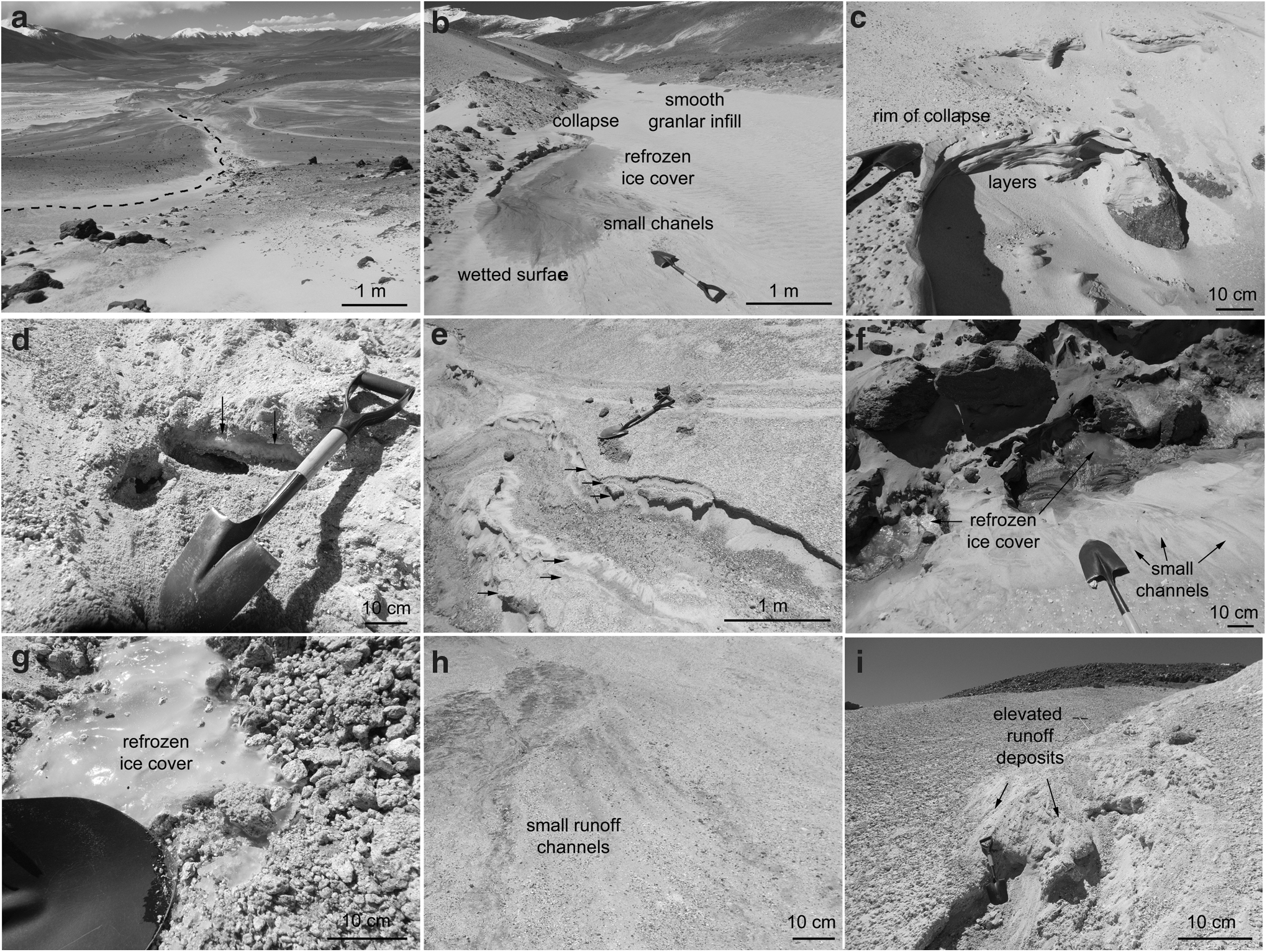
Sample structures and observations of infilled valleys, showing the curving path of the valley
Inside the larger valleys, small sections were active (with liquid water production and flow) only during daytime. The active sections were 1–8 m wide and 4–30 m long, and their floor was lower than the surrounding terrain. These sections became active every day, but in the night, their H2O content was frozen to solid phase. Such active sections were not present in every valley, but they occurred such that at least half of them that made up 2–15% of the total valley's length became active every day.
3.1. Morphology of terrestrial erosional gullies
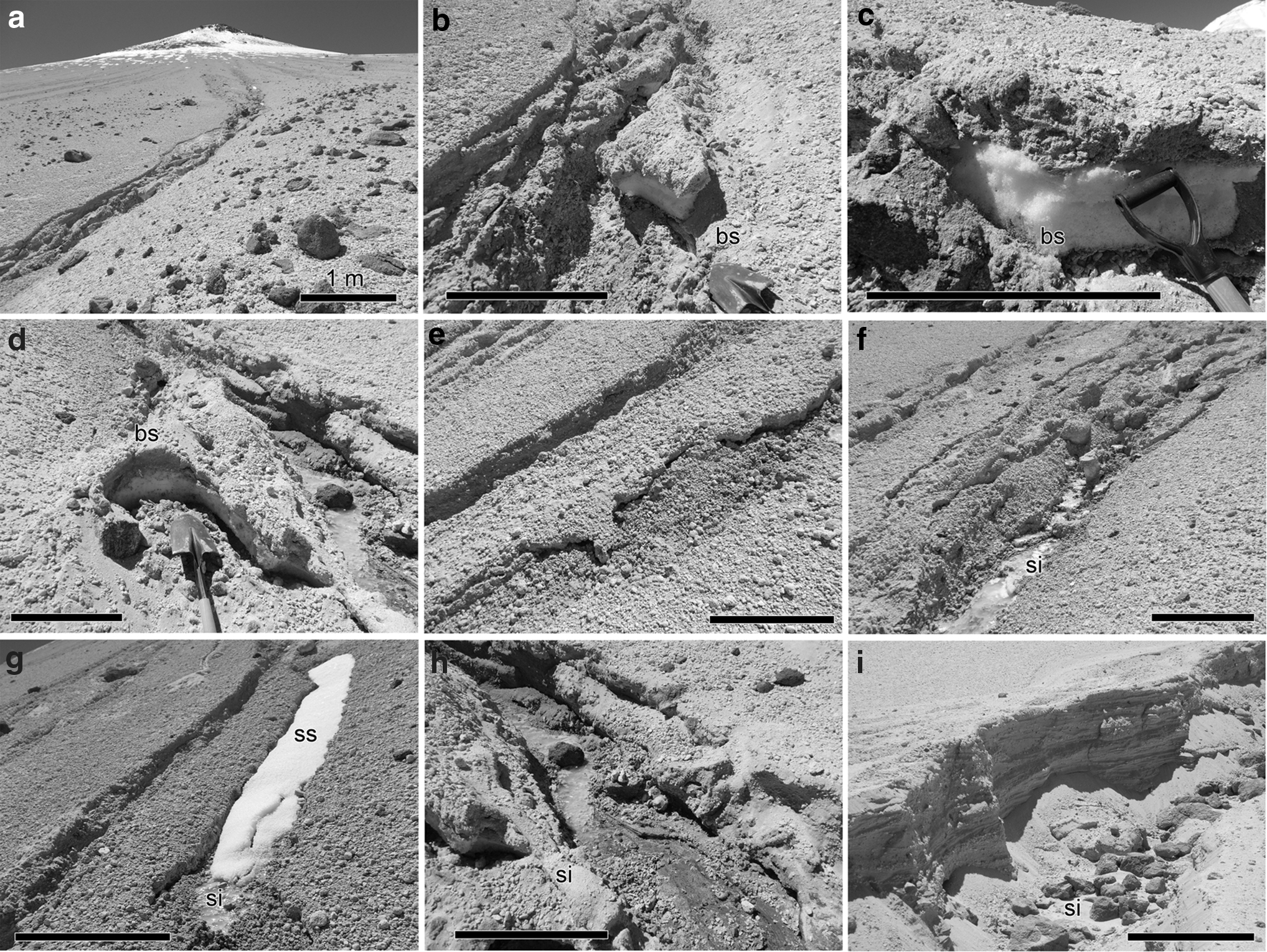
The erosional gullies were relatively common; around 100–200 of them were visible in the surveyed 4–5 km distance near the camp on the slopes. Individual gullies could occasionally merge with each other or terminate in a wider filled valley. Figure 3 shows the main morphological features of the erosional gullies and their water sources. Their longitudinal slope angle ranged between 2–4° and up to 30°. However, the higher values were rare and characteristic only for short distances of about 5–10 m. They did not show alcove depression at their source, and there were no obvious depositional features at their terminus, resembling those seen in martian gully systems. However, some gullies did have fan-like depositional features.
Typical morphological features of the erosional gullies are visible in Fig. 3. Most of the insets (Fig. 3b–g) are located on the hillslope of the volcano that is visible in the panel: erosional gullies (as curved dark lines) cut into the loose debris covered hillside of the volcano (with snow covered around its peak in the distance, looking upslope) (Fig. 3a); sequential collapse produced slices of slumped blocks exposing buried snow of 10–15 cm depth (looking and exposed subsurface along the longitudinal axis of a gully) (Fig. 3b); clean buried snow underneath wind driven loose and porous volcanic debris (looking at an outcrop of a terrestrial gully) (Fig. 3c); the occurrence of buried snow could be followed at least 1 m distance from the erosional channel, suggesting it might be present over most of the volcanic slope area (looking at the terrestrial gully wall) (Fig. 3d); during the collapse, the loosely accumulated mm surface ice (transparent, opposite to the porous white and opaque subsurface snow) is present in the deepest parts of the eroded gully (looking from sideway to the terrestrial gully) (Fig. 3f); example of wind-blown snow partly shielded from the Sun that accumulated during recent (days ice and flowing liquid water at the deepest part of the gully channel (Fig. 3h); layered structure of the exposed debris, pointing to series of depositional and erosional events probably caused by the wind (for the analysis of wind transported grains, see the accompanied paper Kereszturi et al., 2019) (Fig. 3i).
The observations of the erosional gullies suggests these surface structures are dominated by erosion, with activity only in daytime. Depositional features such as wide fans occur at their termination but only for the larger ones (length >15–25 m). The water flowing in them produces a low observed discharge that can transport grains only below the mm size. Their substrate is mainly loose granular debris, including pumice with grain size up to a few mm, although a few blocks of up to 10 cm diameter were observed. The main types of H2O occurrence at the gullies were surface snow inside the erosional channel, buried subsurface snow (both are white, opaque, porous snow), and dense and transparent thin ice layer at the bottom of the trench.
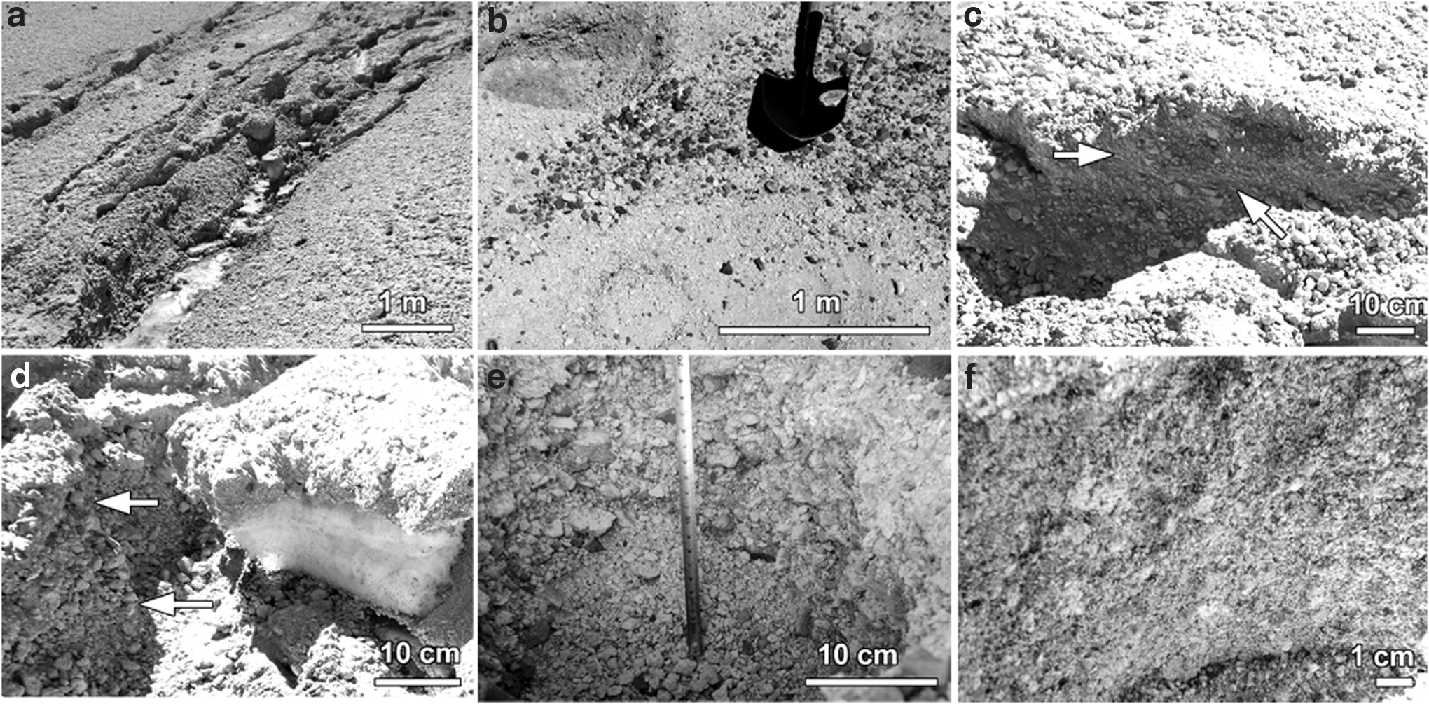
To better understand the geological context of these terrestrial gullies, several excavations were completed to determine the composition of their basement and the extent of the erosion. Example images to characterize their sedimentary settings are presented in Fig. 4a–f:
typical terrain into which they cut, covered by rough debris of volcanic fragments up to 4–6 cm in size, composed of pumice and low-porosity dark rocks with rectangular shape, together with sand-silt (2.0–0.002 mm) size fine debris between them (Fig. 4a);
same as above (Fig. 4b);
a 15–20 cm deep shallow subsurface outcrop (arrows) composed of breccia-like 2–4 cm-sized rough debris and sand-silt (2.0–0.002 mm) sized grains between them in unconsolidated settings (Fig. 4c);
the subsurface is covered by the rough, unsorted, irregular-shaped, about cm sized grains, arranged in a chaotic setting on the top of each other (arrows) (Fig. 4d);
interior wall of a 40 cm deep trench dug into the regolith, showing grain-dominated, unsorted, irregularly shaped volcanoclastic debris (Fig. 4e);
another trench dug by the team revealed a somewhat fine material (cm
Based on the insets a–f in Fig. 4, the material into which the terrestrial gullies are cut is composed of mixed, unsorted, irregularly shaped volcanoclastic grains, with variable occurrence (ranges between 20% and 80%) of silt sand-sized grains mixed into them. The loose sediment was possibly transported here by mass wasting and aeolian processes, under a much more energetic transport regime than the sediments observed in the infilled valleys (see below). This regolith layer was occasionally loose, without cementing ice; however, at certain locations, the regolith was hard and ice cemented. No regularity was found in the occurrence of these cemented and uncemented locations; gully trenches had been cut into both terrain types.
3.2. Morphology of infilled valleys
Excavations were made at several locations in these channels, which revealed that the sediment is cemented by ice in many, though not all, analyzed cases. In the valley, silt, and sand, rarely millimeter-sized pumice grains were cemented occasionally with ice and at certain locations and showed subsurface layering. The materials that fill these wide valleys seem to have been deposited with occasionally interlayered snow. The valleys are larger structures than the erosional gullies, and they show unique sectional activity. Their longitudinal slope angle was between 1° and 4° as well but never reached values as high as were occasionally observed for terrestrial gullies (Fig. 5).
Examples for various observed morphological features related to fluvial activity can be seen in Fig. 5. The panels show the following features:
valley with a bright aeolian deposit in its shallow interior depression (the valley's axis is marked by a dashed line) (Fig. 5a);
a source depression with a collapsed rim, bright refrozen ice at the deepest area, and seep and runoff of melt water from there that darkened the surface (wetted area) with some small (cm width) erosional runoff channel. The floor of the infilled valley is the bright area that fills the panel at the bottom and becomes narrower upward, further away from the observer (Fig. 5b);
closer look at a source depression with protruding layers enhanced by selective erosion of the differently composed and/or ice cemented layers (Fig. 5c);
buried snow (with clean and porous structure) at 8 cm depth below the surface marked with arrows, exposed by an artificial outcrop (Fig. 5d);
layering of the subsurface material (composed of different sized grains and different cementing water ice content) (Fig. 5e);
the source area of the water with refrozen ice covered wetted (and thus dark) material below, where small channel features emanate from (Fig. 5f);
bright refrozen ice that roughly follows the surface topography and probably left behind an earlier water flow episode (Fig. 5g);
small surface runoff features that are partly visible as they wet and darken the grains at the floor of the infilled valley (Fig. 5h);
elevated fine-grained structures that were produced by a viscous flow of grain-water mixture (Fig. 5i).
The panels in Fig. 5 show characteristic images of the infilled valleys. Although the examples shown in the figure are taken from various locations, they are representative of the structures and observations common to all three sites. According to the observations, the following main structural features could be identified.
The first surface feature is a depression that is at least 10 cm deep but can extend down to 40–50 cm in depth. In the exposed walls, buried snow was rarely observed; however, on excavation with a spade, a buried snow layer was present in at least 1/3 of cases. For at least half of all of the analyzed locations (test drills and excavations were made at around 40 locations along three such valleys altogether), ice cement was present as deep, or deeper, than 1–2 cm below the surface of the sediment. These locations are indicated in the Fig. 2c with the dashed elliptical outline with “Fig. 3” text in it. The collapse of the surface produced arcuate theater-headed depressions at many locations, which were enlarged by such a collapse process.
Emanating from the collapse structures listed earlier, there are flow features, for example, carved and elongated, centimeter-wide and millimeter-deep channels, that emanate and bend around various obstacles produced by the collapsed blocks of the wall. After several meters distance (in the case, mainly, of larger systems 2–4 m in size), a flat plain with a braided pattern on its surface could be observed. Over this plain, small channels were observed as curving but nearly parallel branches. This area is darker by wetting than the surrounding terrain of the valleys' infilled floor (Fig. 6).
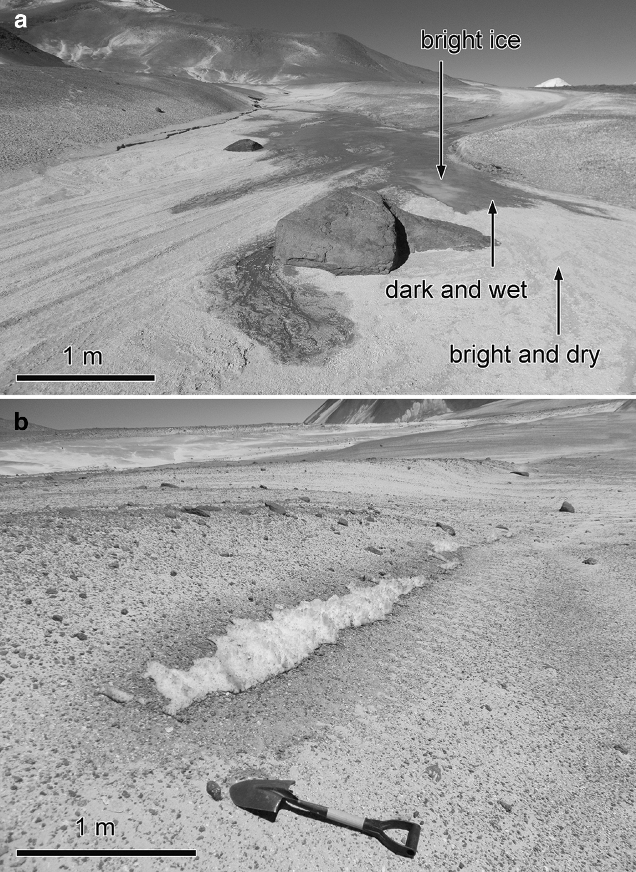
Consequences of wetting on surface albedo.
After around 2–4 m downslope distance (or in the case of larger systems 10–20 m distance), the water flowing in these small channels percolates into the subsurface material and terminates the flow. Sometimes at the end of these flow features (less than half of the observed cases), relict 1–4 mm high, 2–4 cm wide elevated channel-like structures could be observed (Fig. 4i), which were likely to have formed by a more sediment-rich flow earlier. It should be mentioned that shallow ice cement was present at many locations in addition to the active parts of the infilled valleys, and in the percolation area units, the shallow subsurface probably gained back the H2O, and this water might even contribute to the next (day) melting event.
To understand the geological setting of the material that fills these infilled valleys, characteristic example images of the sedimentary setting can be seen in Fig. 7:
curving track of an infilled valley, showing a plain bottom level, whereas the slopes at the steeper surrounding terrain are composed of the same material that is visible in Fig. 3 (Fig. 7a);
a natural outcrop into the valley interior showing parallel, cm-thick layers, composed of different grain-sized and different levels of cementation material, blocks at the melting, and collapsed terrains are in the foreground (Fig. 7b);
the rough material (>cm) is mainly on the surface and rarely below it (here fallen grains are visible in the foreground) (Fig. 7c);
the subsurface exposes different grain-sized layers, mostly with sand
fine-layered material of the infilled floors composed of a few mm thin layers (Fig. 7e);
fine-layered material of the infilled floors composed of a few mm thin layers (Fig. 7f).
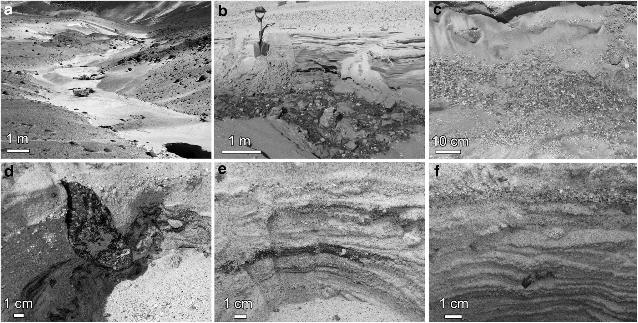
Sample images showing the sedimentary setting of material at trenches were dug into the infilled valleys. See the main text for details. Insets show: track of the valley
The characteristic differences in the sedimentary settings of the infilled fluvial valleys compared with that of the gullies were that the infilled valleys generally had smaller grain sizes, fine layering, and a rarity of boulders above 1 cm. The subsurface layering here was abundant, pointing to such past changing depositional conditions that laid down nearly horizontal layers of different grain size and/or different level of cementation by ice; the largest grains were 2–3 mm diameter here. As these grains were made of pumice, they could likely have been transported by wind; however, mass movements and occasional fluvial transport are also possible (see the sedimentary characteristics mentioned earlier; Figs. 3 and 4).
3.3. Activity and H2O sources
Liquid water flowed only during daytime in both the erosional gullies and infilled valleys. As the day progressed along with the increasing temperature, the discharge slowly increased until the middle of the day, but it then decreased and ceased usually before sunset (the temperature sharply declined around sunset to below zero). During daytime, the activity showed the following characteristics at different locations: The liquid was produced both by melting of transparent surface ice, which results from freezing of the previous day's flows during the night, and by subsurface snow that was exposed at the surface by slumping. Melting occurred under less-than-ideal conditions for the liquid state, as demonstrated by a slow step-like process: First, the frontal end of the flows would progress forward and pass centimeters in distance in several seconds, but then the frontal end would stop and percolation would consume the fresh liquid derived from the flow for some seconds. After this, the cycle would begin again.
An example of flow activity in the morning (9:35 local time) within a 8
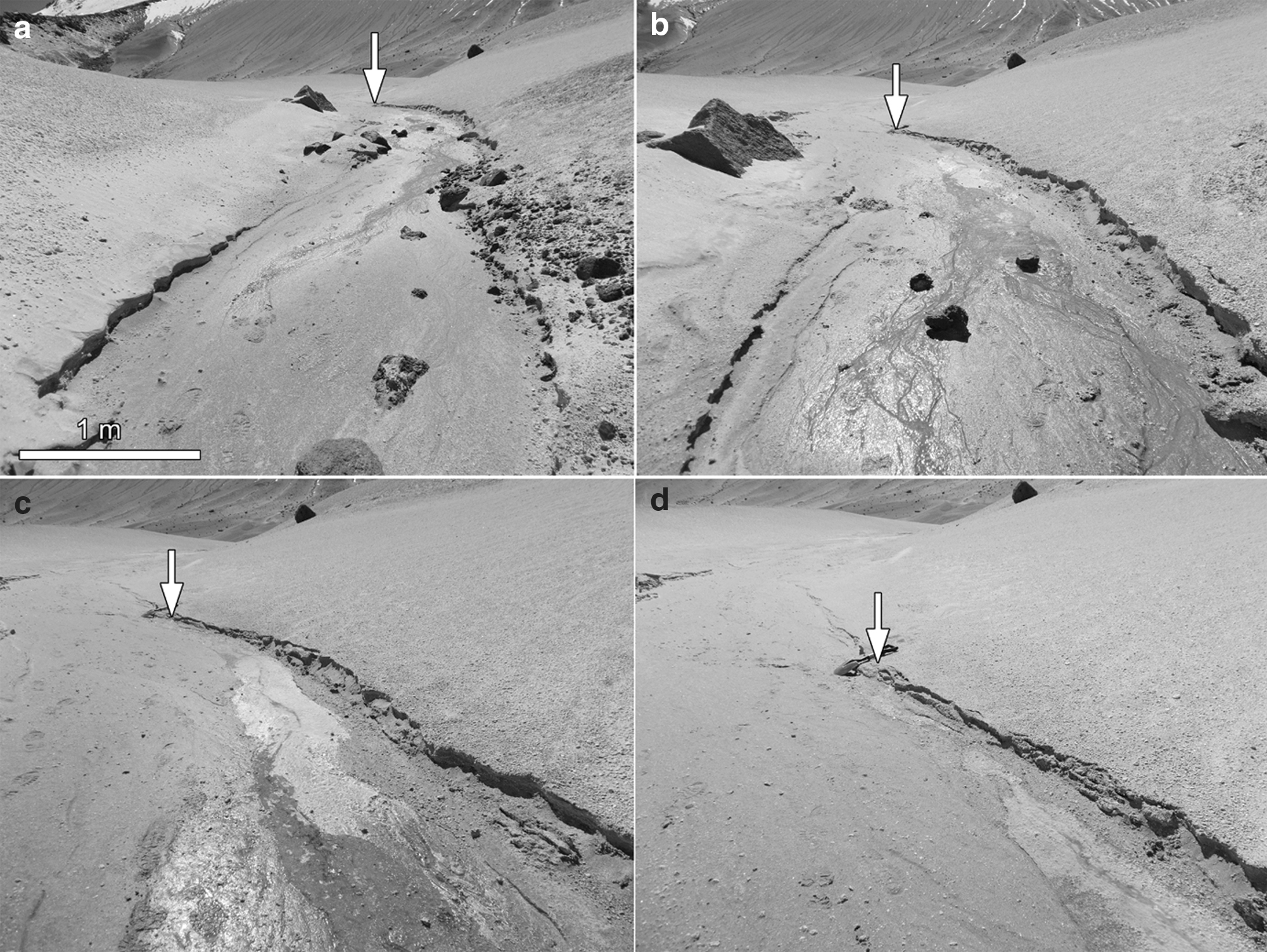
Sample images for daytime activity in an infilled valley with anostomosing-like patter at its bottom
Based on daily temperature measurements, the flow began 1–2 h after sunrise, and it terminated around sunset. The air temperature close to the ground was above zero. It is also worth mentioning that, at around zero Celsius air temperature, ice was still present at a few locations and covered the surface in the daytime, and below this layer, liquid water was percolating horizontally. The presence of salts due to a decrease in the freezing point was not observed. Melting of snow and ice occurred, but no contribution of brines was observed.
Ice and snow occurred in the following characteristic locations both in the erosional gullies and in the infilled valleys. At the infilled valleys, ice as cement between grains constituted the smooth infilled areas that were present below at around 1–2 mm depth, and it often prohibited or hindered the excavating process. A transparent surface ice layer a few mm thick was present at the collapsed depressions of the valleys at their deepest locations. This ice was present in the morning for some hours after sunrise, but then it melted in most cases around the warmest hours and reformed in the late evening. It stayed on the surface during the night and did not sublimate away probably due to the sub-zero night-time low temperatures. In this layer, the H2O was stored in the form of refrozen ice from the already flowing water from previous days.
Buried snow of a white color, with a clean and porous structure and a thickness of 8–20 cm, was covered by a 5–25 cm thick layer of volcanic grains that were present at many locations. No regularity could be seen regarding the spatial occurrence of these buried snow masses, although they seemed to be present mostly at fine-grained and loose material covered areas. The less frequent occurrence of H2O was fresh snow on the surface, mainly at small depressions where it was trapped from rare precipitation. The partly wind and solar insolation shadowed locations supported the melting of snow instead of sublimation during daytime. This snow might be ephemeral at this height and came from a snowfall event on the third day of the expedition—but became covered and thus could exist for a much longer duration.
4. Discussion
Two types of water flow-related features were identified in the Ojos del Salado region and are presented in Section 3. These features appear to be characteristic of the studied area in the high-altitude Atacama Desert during the local summertime period. Here, we first discuss potential methods of formation and, secondly, we consider their relevance to Mars. Regarding the source of the water flowing in both the erosional gully and infilled valley structures, four configurations were identified, which are related, in part, to each other.
Buried snow was present at both fluvial features and was probably produced by atmospheric precipitation that was then shielded from ablation by wind transported grains. Unfortunately, the date of the precipitation event could not be calculated. The snow deposit might have formed in the previous winter, but more probably several years ago, and buried snow patches at different locations do not necessarily have the same age.
Fresh snow could have been the source for both structure types; however, during the field work below around 5500 m altitude (where all the observed targets were located), no snow was present at the surface, except within some narrow channels including the depressions of some gullies. Based on the inhomogeneous distribution of this snow, it was left behind from the rare and unexpected snowstorm that happened 2 days before the start of the field work (on the third day of the expedition). The snow cover might have been continuous right after the precipitation but sublimated away at most (nonshielded sites) below 5500 m elevation, whereas, for example, in some gullies it remained for a longer duration and probably contributed to the flow by melting.
Transparent surface ice was present at the collapsed depression of infilled valleys' sources, and rarely in erosional gullies. This formed during the night from freezing of the daytime melt water, providing the storage of H2O for the next day, which was stable as solid ice only during the night.
Shallow subsurface ice was observed as widespread cement in the fine-grained valley filling material and might also contribute to the melt production.
The level of contribution to the runoff from the different H2O sources is difficult to estimate, but based on the observations, the thin surface ice and the directly exposed surface snow (where it was present) played a smaller role in producing the observed discharge than the other sources, but further work and more field data are necessary to get more details on their relative contribution. The observed gully trenches show examples of how such trench-like valleys, which resemble martian gullies, acquire their H2O source. The morphological features observed at gullies suggest that melting and related transport of earlier existing surface or mainly subsurface snow resulted in collapse of the surface, which formed an elongated depression. Inside this depression, transport of material was observed, which suggests that collapse and classical fluvial transport contribute to their formation.
The sedimentary setting of the terrestrial gully features and that of the infilled valleys were different. In the first case, the unsorted, irregularly shaped rough debris may have come from mass wasting and wind-driven processes in a chaotic form, with the infilled valleys exhibiting mostly fine-grained size material and rarely having occurred above cm-sized blocks. The fine material often showed layering in both composition and grain size, suggesting probable earlier fluvial transport. However, wind action may also have contributed to the deposition. Although the fine-layered material suggests a moderately calm depositional environment, the energy of the transport may occasionally have been greater, based on grains up to a centimeter in size that could have been carried by winds and not the generally small discharge flow that was observed during field work.
Although the origin of erosion-dominated gullies seems to be straightforward under the climate that was present during the field work—given that the production and the flow of water was observed directly—this was not evident for the infilled valleys as their sectional activity would have produced much less discharge than that required for the erosion of these size valleys. The observed sectional activity was probably not enough to produce the infilled valleys regarding the needed level of erosion and deposition, as their current discharge could not have transported away the larger (cm-sized) blocks that should have been present at the depression of these valleys given that they were exposed along their walls, as the depth of the water at the active sections was around a millimeter scale. However, the wind-transported grains could easily have filled them. It is not necessarily the case that all channels would have to have been filled by water. Only a relatively small length (for example, 30–40 m along part of a kilometer-long valley) might have been filled by flowing liquid at a given time as a very thin (mm) liquid layer for a fraction of width.
It is worth mentioning that no inactive depressions were present where earlier similar melting activity could have occurred. There are two main possibilities to explain this situation: (1) No such earlier activity was present in the valley earlier, and the observed features were the first ones to occur, which seems improbable as it is not likely that the site was visited exactly at the first emergence of such features, which were large in number. (2) Earlier activity (earlier formed depressions) could have been filled by wind-driven grains on annual timescales in agreement with the observation that an interbedded snow layer was found in the subsurface covered by this dust
Based on the relatively small total discharge, the length of active sections, and the lack of a current source for larger discharge, these valleys might have been produced by some more energetic and volumetric processes than such relatively small active sections. Based on the field survey, infilled valleys, in accordance with their larger size, were produced by larger and potentially longer duration discharge than erosional gullies. The exact source for valley formation is unknown; however, among the theoretical possibilities, formation under somewhat more humid past climate conditions might have been more likely by the melting of formerly existing ice, and not necessarily by precipitation, as has been indicated by previous research efforts in this region (Stansell et al., 2007). There were no observable signatures, however, that would suggest the formation of the depressions at the infilled valleys.
There are several cyclic or periodic aspects of activity at the observed gullies and infilled valleys. The importance of daily temperature-related freezing/melting cycles was seen in the form of night-time inactive water channels. The sequential formation means that several parts of each valley might have been active at the same time, whereas a substantial part (roughly around 50% or more) might have been inactive, separated by active units. A general contribution to the periodic/cyclic activity is that part of flowing water could have been stored “in the system” for later activity, which was probably the next day in several cases. The transparent frozen surface ice and the pore ice from the subsurface percolated water could be two example types for such H2O storage, as suggested for brines in the work of Sears and Chittenden (2005).
4.1. Comparison to features on Mars
Both feature types analyzed in this work are larger than gullies on Mars (Gulick et al., 2018). Gullies on Mars are elongated erosion features that produce trenches on steep slopes, mainly situated at the middle- to high-latitude region of Mars (Malin and Edgett, 2000; Dickson et al., 2007). They usually have an erosional alcove and a terminal depositional apron (Harrison et al., 2015). Surveys of gullies have been implemented for Palikir crater (Narlesky and Gulick, 2014; Hamid and Gulick, 2018; Luu et al., 2018), Corozal crater (Hernandez et al., 2014), Moni crater (located in Kaiser Crater, Glines and Gulick, 2014), Asimov crater (Paladino et al., 2018; Langenkamp et al., 2019), and Hale crater (Corrigan et al., 2017), among others. Based on the detailed research by Gulick et al. (2018) for Lyot crater, gully lengths range from 2.2 to 4.3 km with maximum depths from 17 to 54 m. Alcove slopes range from 20° to 22°, channel slopes from 12° to 16°, and apron slopes from 10° to 14°. These values may be characteristically true. Gullies, in general, have V-shape cross-sections.
Survey longitudinal profile results for various terrestrial debris flow gullies have indicated steeper and less concave features as opposed to fluvial gullies (Conway et al., 2015); gully long profiles on Mars resemble both profiles of terrestrial gullies formed by either fluvial or debris flow processes, with slightly more resemblance to fluvial systems. These gullies possibly formed by water flow and/or seasonal frost processes (Head et al., 2008). Those observed at the Ojos del Salado region were two to five times smaller. A partial similarity in the formation of source H2O when considering Mars versus Earth is that shallow subsurface ice is hypothesized for martian gullies in the form of a latitude-dependent mantle (Johnsson et al., 2014); whereas current accumulation of frost inside the gullies has also been observed on Mars. However, other than one suspected uncertain indication, no firm signature of current liquid flow related activity is present on Mars.
The periodic temporal activity that was observed only during the daytime at Atacama might also be relevant for Mars, because above-freezing temperatures are achieved in daytime only (Johnsson et al., 2014). Many hypotheses have been put forth for the formation methods of martian gullies, and the closest that is consistent with our observations involves the melting of snow packs (Christensen, 2003), which deposit as LDM in the form of surface snow/ice (Johnsson et al., 2014). Recent works suggest that the latitude-dependent mantle might be glacial in origin, and occasionally these might be up to 100 m deep (Dundas et al., 2019), which could have accumulated by way of snowfall but, more likely, were compacted into massive, layered ice as opposed to the earlier supposed highly porous, noncompacted ice. At some locations at the middle latitude range, these accumulations are exposed by recent impact events (Byrne et al., 2009). It is probable that, although the water ice was likely deposited from atmospheric precipitation, such accumulations are very loose and partly compacted and may cover up to 23% of the surface, occasionally with 30 m or greater outcrops on the polar-facing slopes (Balme and Conway, 2014). Similar accumulations may have been identified at locations at the surveyed analog site (Nagy et al., 2020).
Accurate thermal modeling of the melting of snow and ice in the Atacama could be realized based on measurements of insolation in the future, which could support the modeling of similar melting processes on Mars. The exact mechanism that leads to the melting of H2O ice is not clear, but because it is spatially associated with subsurface exposed snow within depressions formed, in part, by mass movements, and because liquid flow was present only in daytime, we hypothesize that the activity was supported by the exhumation- and insolation-driven melting of subsurface snow.
The surface storage of water ice that could arise from the freezing of the already melted H2O in evening is a new observation, and a similar mechanism has not yet been suggested for Mars. The storage of ice on the surface at night is favored by lower temperatures that decrease sublimation rates (Chittenden et al., 2008) on Earth and likely on Mars as well. The relative humidity at the Ojos del Salado region at 5200 m elevation ranged from 0.2–0.5 daytime to 0.6–1.0 night-time, which resembles recent findings on Mars (Pal, 2019). In the case of active melting on Mars, even with high sublimation, liquid flow to restricted distances is believed to be possible based on laboratory study calculations (Conway et al., 2011; Massé et al., 2016).
Regarding the earlier mentioned potential current, or recent candidate, flow features on Mars, RSLs are not as deep as are terrestrial gullies and infilled valleys on Earth (actually no vertical relief, e.g., depth was identified for RSLs). However, the observed darkening of the surface (Fig. 6) might be a useful analog here. The observations in the Ojos del Salado suggest that subsurface stored water ice could produce dark flow features under general surface dryness with even small amounts of liquid flow. Also, the interlinked steps of melting-flow-percolation-freezing can retain a substantial portion of available H2O for several flow occurrences, because of reduced H2O loss and storing. Recurring dark streaks might also emerge without the need for “new” H2O input between different flow episodes. Thus, storage of H2O for a later flow episode should be considered for RSLs on Mars.
Terrestrial gullies presented here are relevant to the study of martian gullies, despite that they are much smaller than their martian counterparts, as they cut into the surface, show evidence of erosion, and are supported by subsurface melting. It should be emphasized that shallow buried subsurface snow plays an important role similar with that which is suspected to occur on Mars. Our observations suggest that subsurface melt-produced collapse may be of great importance not only because of the formation of flowing liquid but also for the released volume that could trigger the collapse process, which contributes to the downward motion on steep terrain. Collapse after the removal of buried snow could produce much deeper channels than would fluvial erosion by regular transport. The daily cycling activity of refreezing after melting and keeping the H2O at the site for the next active period at a lower reach along the eroded channel (see e.g., Fig. 3g) should also be taken into consideration for martian gullies. Further analysis of how mass movement produces exhumation of subsurface snow and results in liquid flow without an identified initiation process is Mars relevant, as the initiation might be as difficult to identify on Mars as on Earth.
5. Conclusions
During the field expedition in February of 2018, several flow features were analyzed at Ojos del Salado, a volcanic peak in the Atacama Desert region with an altitude of around 5200 m above sea level. Two types of structures were identified at Ojos del Salado, and a unique flow regime was found to be connected to them, which could have relevance to similar martian structures. Gullies on Ojos del Salado, which are somewhat smaller than those on Mars, were observed and expressed mainly as erosional features, where three types of H2O sources were identified: buried snow, surface snow, and ice left behind from the refrozen liquid water. This latter water source has not yet been suggested as having occurred on Mars.
The analyzed site at Ojos del Salado is unique in that, even though it is in the hyperarid Atacama region, rare snowfalls produce runoff despite the elevated sublimation rate. The accumulation of H2O from rare snowfall events is facilitated by the burial of loose sediments that are transported by strong winds in winter in excess of 60 km/h (as calculated by the Meteoblue Weather Forecast company by using models of NOAA/NCEP). Thus, such rare and ephemeral melting could be supported in this dry area by the strong interaction of snow and wind activity that might quickly cover the fresh snow before it sublimates away.
Other flow-related feature groups called infilled valleys are active only in the daytime and exhibit a spatially discrete distribution. The active sections are composed of a source depression where liquid H2O is produced from subsurface buried sources, but then they flow downslope and are later percolated into the fine-grained infilling material of the valley. Several such active sections can occur along one valley, separated by an inactive section. The active sections usually make up less than one third of the valleys' total lengths. The origin of these structures is unknown, given that, under current climate conditions, large sources of water are not likely to occur, and the specific flow regime mentioned earlier could not produce such considerable sized valleys.
The features mentioned earlier, however, might have Mars relevance for gullies with respect to flow regimes and sources. The reason for the observed spatially sectioned activity is poorly known; however, it could be due to the interaction of insolation and mass movement of exhumed subsurface snow.
Footnotes
Author Disclosure Statement
No competing financial interests exist.
Funding Information
This project has been supported by the COOP_NN_116927 and the GINOP-2.3.2-15-2016-00003 grants of the Hungarian National Research, Development and Innovation Office (NKFIH).
Abbreviations Used
Associate Editor: Christopher McKay