
Abstract
The spatiotemporal distribution and potential ecological risks of eight heavy metals, including chromium (Cr), copper (Cu), zinc (Zn), arsenic (As), cadmium (Cd), mercury (Hg), lead (Pb), and tungsten (W) in the sediments of the Taojiang River in southern Jiangxi Province, were investigated over three hydrographic periods. Sediment samples were collected from 36 sampling sites surrounding and downstream of the Taojiang River for deeply distributed tungsten (W) and rare earth ores. Results revealed that the average concentration of W in the sediment samples was more than three times higher than the soil background value of Jiangxi Province during high-water and normal-water periods and nine times higher during the low-water period; the variation coefficient of W was more than 100%, which indicated that W distribution was extremely heterogeneous. The Eri revealed that Cr, Cu, Zn, Pb, As, and W showed slight ecological risks. On the other hand, Cd and Hg showed high ecological risks and their total contribution rates to risk index were above 96% in all three hydrological periods. Therefore, in terms of heavy metal contamination in the Taojiang River, especially Cd and Hg, necessary measures should be undertaken to protect rivers in southern Jiangxi.
Introduction
The southern Jiangxi (China) is known as “the tungsten (W) capital of the world,” where W was first discovered. Currently, it is the largest W production and exporting region in China, accounting for 26% global and 39% of the county (Sun, 2017). In addition, southern Jiangxi is also known for its rare earth ore resources, containing 30% ionic rare earth element (REE) resources of the world (Liu et al., 2015). W mines in southern Jiangxi have been exploited for more than 100 years. The early disordered W mining caused serious pollutions to the areas surrounding the mining sites and to the downstream aquatic environments, especially the direct discharge of W tailings and heavy metal wastewater containing lead (Pb) and cadmium (Cd).
In recent years, heavy metals have attracted a great deal of attention due to their persistence, bioaccumulation, and inherent toxicity to the aquatic environment (Halina et al., 2015). River sediments act as a reservoir or sink of heavy metals for aquatic organisms (Wang et al., 2016). In addition, with the physical and chemical properties of the overlying water change, several of the sediment-bound metals can be released into the water column through sediment resuspension, desorption reactions, and reduction or oxidation reactions, causing secondary pollution (Magdalena et al., 2014) and endangering human health (Varol and Sen, 2012). River sediments with heavy metal pollution have become a global problem (Sundaray et al., 2011; Gao and Chen, 2012; Li et al., 2012; Rajeshkumar et al., 2018). A series of relevant investigations have published, as listed in the following. The heavy metal total contents in the surface sediments of the Xiangjiang River (Hunan, China) were measured by the inductively coupled plasma mass spectrometry and atom absorption spectrophotometer, and the Hakanson ecological risk index was adopted to assess the potential ecological risk of heavy metals in the surface sediments, and continuous experiments were carried out to study the effect of flow rate and initial pH values on the heavy metal release from sediments (Zhong et al., 2018). The principal component analysis (PCA) and Pearson correlation analysis were used to deduce heavy metal element potential emission sources, and the geoaccumulation index, enrichment factor, and the Hakanson potential ecological risk index were calculated to evaluate the pollution degree and ecological risk level of heavy metals in sediments in Hejiang River (Guangxi, China) (Ning et al., 2017). Geochemical and statistic methods were applied to analyze the spatial distribution and correlation of heavy metals in sediments of the Nanpan River (Yunnan, China), and the degree of contamination and major pollutant elements were assessed using the enrichment factor, pollution loading index, and geoaccumulation index (Xiong et al., 2017). The microwave digestion and atomic absorption spectrophotometry were adopted to determine the heavy metal contents of Taizi River (Liaoning, China), and the river sediment pollution degree of heavy metals was evaluated with the geoaccumulation index evaluation method (Wang et al., 2017). Sixty samples were taken from four different sites at the Tapti River (India) and analyzed to examine heavy metal contents; geo-accumulation index was used to evaluate the contaminations (Bhavna et al., 2013). Surface sediment samples of 10 stations along the Feni River (Bangladesh) were analyzed and the enrichment factor, geoaccumulation index, contamination factor, and potential ecological risk index were used to evaluate heavy metals, respectively (Islama et al., 2018). In the southern Jiangxi, the typical areas of W, ionic REE mining leads to high concentrations of strong acid, ammonium, and heavy metal ions in river water and sediment. However, the unique characteristics of sediment and water quality, as well as the distribution of heavy metal pollution in the river ecosystems, are still insufficiently known.
In this study, the potential risks of eight heavy metals, including chromium (Cr), copper (Cu), zinc (Zn), arsenic (As), Cd, mercury (Hg), Pb, and W sedimentary pollution in the Taojiang River, were investigated. Taojiang River, located in southern Jiangxi Province, is a secondary tributary of Ganjiang River (Jiangxi, China). This river flows through Quannan, Longnan, and Xinfeng Counties hosting many mining activities. These areas are particularly important for water-quality investigations and pollution control for the river. In addition, there are several W and ionic REE tailings densely distributed along the river. The heavy metals were analyzed over three hydrological periods to determine the spatiotemporal characteristics of their concentrations and to identify the main pollution sources. This study is expected not only to provide theoretical support and scientific basis for the pollution control of Taojiang River but also to act as a reference for the design and construction of the Ganjiang River.
Materials and Methods
Study area
Taojiang River (24°29′ to 26°17′N, 114°10′ to 115°19′E) originates from Mountain Fanchi and flows through the Quannan County (Jiangxi, China) (Wu, 2012), where 277 abandoned ionic REE areas and several W mines are distributed. In the middle and lower reaches, Xinfeng and Longnan counties are the main producing areas of ionic REE in southern Jiangxi. This river basin is located in a subtropical area and under a humid monsoon climate; river runoff varies with seasons, with high-water periods in spring and summer, low-water period in winter, and normal-water period in autumn.
Sample collection and pretreatment
In the present study, sampling campaigns to collect sediments in the Taojiang River estuary were conducted in high-water period (June) and normal-water period (October) in 2017, and low-water period (January) in 2018. Thirty-six sampling points were established in the estuarine area (Fig. 1). Thirty-six sampling sites were arranged with full consideration of mining activity, wastewater discharges, hydrology, and river bed tributaries in the sampling section (Table 1). The sediments were collected by a multipoint mixing method. A stainless-steel grab sampler was used to collect sediments in the depth of 0–10 cm beneath the sediment/water interface, and then, samples were stored in an ice bag until being returned to the laboratory. The sediment samples were air-dried, and the impurities such as gravel, shells, animals, and plant residues were removed, followed by grounding using an agate mortar and sieved through a 200-mesh nylon sieve and stored in a polyethylene bottle at 4°C until analysis.

Location of sampling sites in the Taojiang River of Jiangxi, China.
Environmental Characteristics of Sampling Locations
Sample analysis and data processing
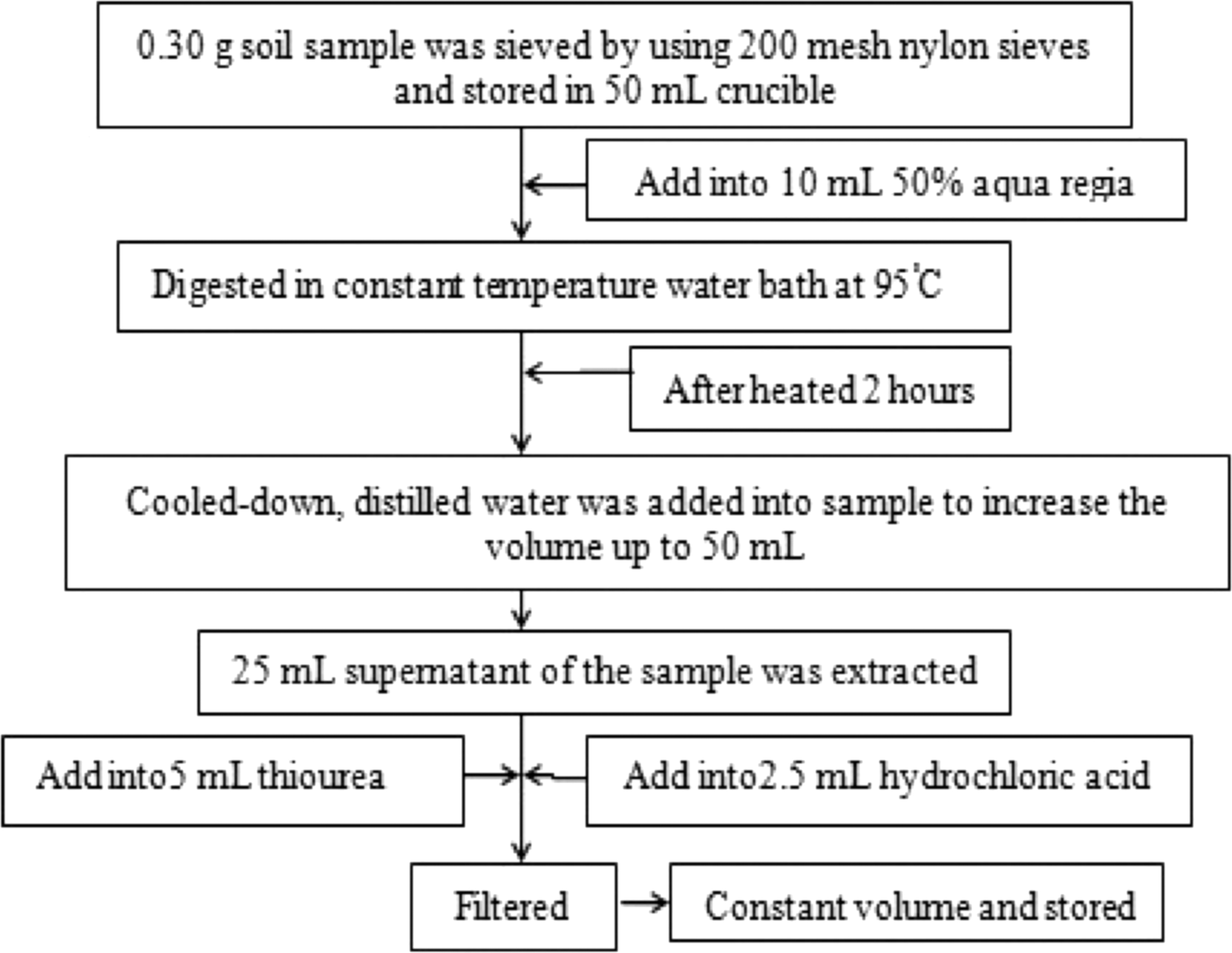
The concentrations of Hg and As in sediments were measured by atomic fluorescence spectrometry with a sample pretreatment, as shown in Fig. 2. The W, Cu, Pb, Zn, Cd, and Cr were measured by inductively coupled plasma mass spectrometry (ICP-MS Agilent 8800) (Bednar et al., 2010) with a sample pretreatment, as shown in Fig. 3. The software programs SPSS 22.0, Origin 2017, Canoco for Windows 4.5, and ArcGIS 10.0 were used for data processing, analysis, and mapping of the heavy metals in the sediments. The soil background values of the considered heavy metals in Ganzhou City and Jiangxi Province are listed in Table 2.
The measurement flowchart of pretreatment for heavy metal concentrations with the atomic fluorescence spectrometry method.

The measurement flowchart of pretreatment for heavy metal concentrations with the inductively coupled plasma mass spectrometry method.
The Reference Value of Each Metal Element (mg/kg)
As, arsenic; Cd, cadmium; Cr, chromium; Cu, copper; Hg, mercury; Pb, lead; Zn, zinc.
Ecological risk assessment
At present, the assessment of heavy metal pollution in water and sediment is quite mature. A geoaccumulation index, p-value risk assessment, risk assessment code, and potential ecological risk index (RI) (Song et al., 2015a) are commonly used. For another, RI includes biotoxicology and ecology. Thus, in this study, RI was used to evaluate ecological environmental risk (Hakanson, 1980). The calculation formula and evaluation criteria are as follows:
where RI is the potential ecological risk index, Eri is the potential ecological hazard coefficient of a single heavy metal, Tri is the toxicity response coefficient of heavy metal i, Ci is the measured content of heavy metal i in soil, and Cni is the background value of a heavy metal in soil. The toxicity response coefficients of Cd, Cr, Cu, As, Pb, Zn, and Hg were 30, 2, 5, 10, 5, 1, and 40, respectively. The biotoxicity coefficient of W is not reported, while W and Cr are from the same group of elements with similar geochemical behavior; but W biotoxicity is lower than Cr. Therefore, the biotoxicity coefficient of W is set as 1. The ecological risk assessment indicators (Eri and RI) are classified along with the risk degree (Table 3).
Ecological Risk Assessment Indicators and Grading Criteria
Results
Temporal pattern of sedimentary heavy metal contents
The total concentrations of the eight heavy metals were in descending order as Zn>Pb>Cu>Cr>W>As>Cd>Hg. The average sedimentary content of each element during the three different hydrological periods was as follows: Zn>Pb>Cu>Cr>W>As>Cd>Hg in high water; Zn>Pb>Cu>Cr>As>W>Cd>Hg in normal water; and Zn>Pb>Cu>W>Cr>As>Cd>Hg in low water (Table 4). The only element that changed its position over the three periods was W, which may indicate that the accumulation and release of heavy metals in sediment are a slow process, and the difference in natural conditions is relatively small over the short term. All of the heavy metal concentrations, except Cr, were higher than the background values of soil in Ganzhou City of Jiangxi Province and were higher than the background value of soil in Jiangxi Province during the high-water and normal-water periods. All heavy metal concentrations exceeded this standard in the low-water period. The average concentrations of Zn, Pb, Cu, As, Cd, and Hg in the high-water period were 2.5, 1.5, 2.8, 2, 41, and 17.3 times higher, respectively, than the soil background value of Ganzhou City, and W was 3.6 times higher than the soil background value of Jiangxi Province. In the normal-water period, the average concentrations of Zn, Pb, Cu, As, Cd, and Hg were 2.2, 1.4, 3.2, 2.1, 31.2, and 14.8 times higher, respectively, than the soil background value of Ganzhou City, and W was 3.3 times higher than the soil background value of Jiangxi Province. Finally, in the low-water period, the average concentrations of Zn, Pb, Cu, As, Cd, Hg, and Cr were 2.2, 1.8, 3.1, 2, 51.6, 10.3, and 1.0 times higher than the soil background value of Ganzhou City, respectively, and the W concentrations was 9 times higher than the soil background value of Jiangxi Province. The Zn unqualified rate was 97% (high-water period), 94% (normal-water period), and 97% (low-water period) during the three hydrological periods, followed by As, Pb, and W, where the unqualified rate varied between 67% and 92%; the unqualified rate was the highest in the low-water period. Cr was 22% and 25% in high-water and normal-water periods, respectively, and reached 53% in the low-water period. The Cu, Cd, and Hg all reached 100% during the three hydrological periods. In terms of variation coefficients, Hg and W were more than 80% during the three hydrological periods, while Cd was 147% in the low-water period, indicating a high degree of variation. Other elements were between 20% and 60%, suggesting that the temporal distribution of heavy metals was significantly uneven. Overall, the average concentrations of Cr, Cu, Zn, As, Cd, Hg, Pb, and W were higher in the low-water period, followed by the normal-water period, and lowest in the high-water period.
Heavy Metal Contents in the Sediments of Taojiang River (Jiangxi, China) During the Different Water Periods (mg/kg)
Spatial distribution of sedimentary heavy metal content
The concentrations of eight heavy metals in sediment samples at 36 sampling sites are shown in Fig. 4. The concentrations of Cu showed an overall increasing trend from upstream to downstream. The concentrations of Cr first increased and then decreased from upstream to downstream with maximum concentrations at Site 14 (Quannan County) and Site 27 (highway construction). The concentrations of Zn showed an overall decrease trend from upstream to downstream. The concentrations of Pb showed a small fluctuation. The Hg content was highest at Sites 4 and 15, with little change at other sites; As was relatively high and fluctuated upstream to Site 27, among which, Sites 5, 14, 22, and 27 were located near the junction of the Dajishan tributary. The content of W gradually increased from upstream to Site 5, with a maximum content at Site 4 near the Dajishan tributary, and then gradually decreased downstream. Site 34 (the junction of Quannan and Gan Counties) had a higher content of W. Cd increased gradually from upstream to Site 5, influenced by the Dajishan tributary influx; there was a significant decrease at Site 8, and increased volatility between that site and Site 27. Compared with the farmland soil pollution risk control values (GB 15618-2018), only Cd exceeded the standard, which was distributed from Sites 4 to 6 and from Sites 26 to 28 near the Dajishan W mine over all three hydrological periods. Spatially, the concentrations of heavy metals were relatively stable in the three hydrologic periods. On the whole, eight heavy metal concentrations were higher in the Huangtian River to Longnan section, Longnan tributary, and Xiaomu and Tianzhai Rivers, while other river sections were relatively low (Fig. 4).
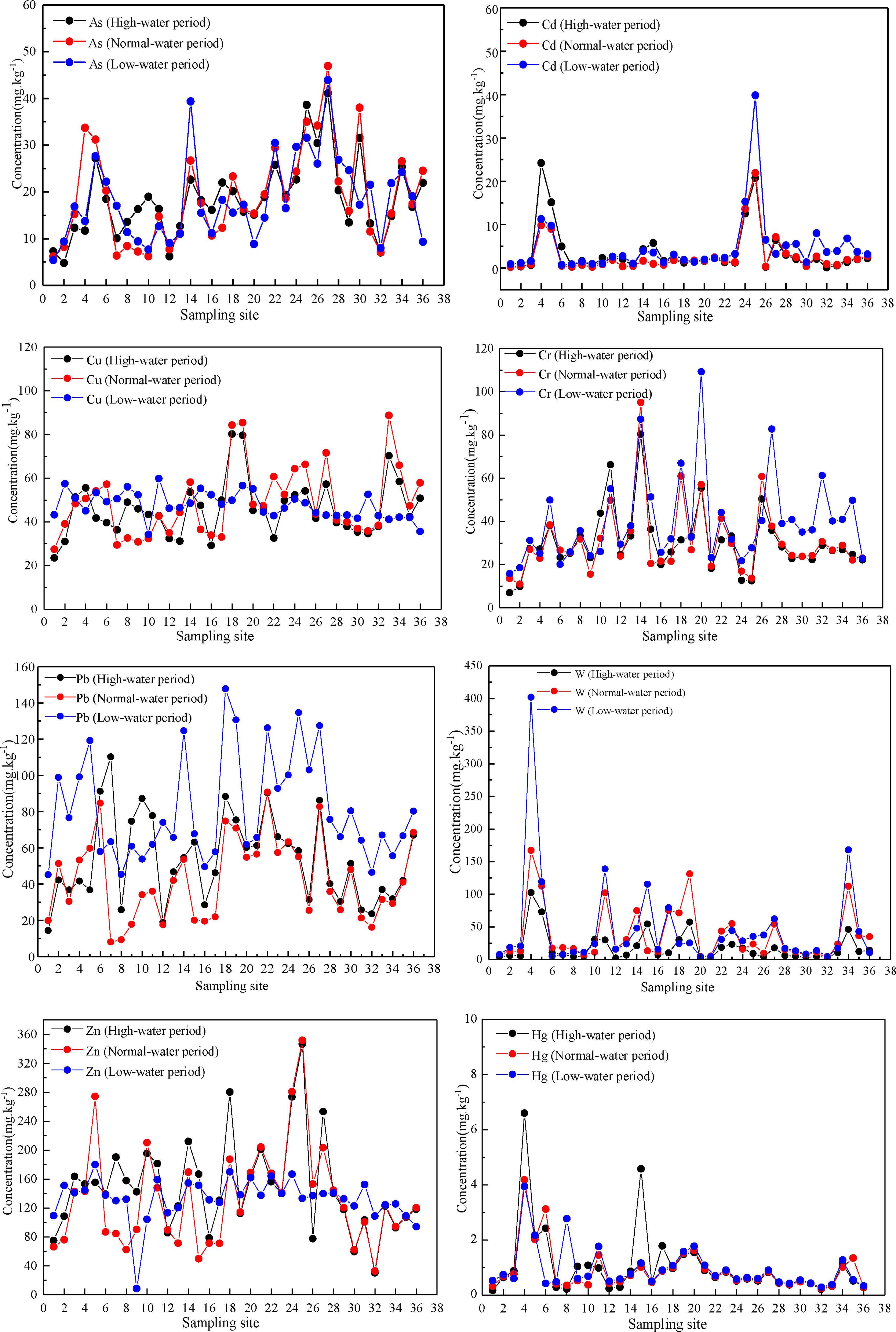
The spatial distribution of heavy metal contents in sediments of the Taojiang River (Jiangxi, China) during the different water periods (mg/kg).
Source analysis of sedimentary heavy metals
Correlation and PCA of the eight heavy metals over the three hydrological periods were carried out (Fig. 5). A determination of the heavy metal sources is crucial for the effective control of heavy metal pollution. There are two main types of heavy metal sources: the earth's crust and the human activities. A good correlation between the pollutants indicates that they may have similar sources (Liu et al., 2017). During the high-water period, there was a significant correlation among W, Hg, and Cr, and Cd and Cu were significantly correlated. The first PCA axis explained 52.8% of the environmental variables in Taojiang River sediments, and the second axis explained 21.9% of the environmental variables; accumulatively, this explained 74.7% of the variables. In the PCA, heavy metals with higher correlation coefficients with the first and second axes were the main environmental impact factors. Zn, Pb, W, and Hg were the main environmental factors in the sediments during the high-water period; Zn (0.850) and Pb (0.723) were positively correlated with the first axis, and W (0.931) and Hg (0.928) were positively correlated with the second axis. In the normal-water period, there was a significant correlation among W, Hg, Cr, Cu, Pb, and As; Cd and Zn also had a significant correlation. The first PCA axis explained 58.4% of the environmental variables, and the second axis explained 19.4% (cumulative 77.8%). The main environmental factors were Zn, Hg, Cd, and W, with Zn (0.899) and Cd (0.822) showing a positive correlation with the first axis, and W (0.944) and Hg (0.930) showing a positive correlation with the second axis. During the low-water period, there was a significant correlation between W and Hg, as well as Cu, As, Pb, Zn, and Cr. The first PCA axis explained 62.7% of the variables and the second explained 16.4% (cumulative 79.1%), The main environmental factors in the sediments were W, Hg, Zn, and Pb, with W (0.925) and Hg (0.952) positively correlated with the first axis, and Zn (0.823) and Pb (0.652) positively correlated with the second axis. The PCA results showed that the major environmental factors in sediments during different hydrological periods shared similarities and differences, with W, Hg, and Zn as the common major environmental impact factors.

PCA diagram of heavy metals in sediments in the Taojiang River. High-water period
Evaluation of potential ecological risk
Eri indicated that all the sampling points of Cr, Cu, Zn, Pb, and W during the three hydrological periods were slight ecological risks (Table 5). A few sites showed that As posed moderate ecological risk, while the rest were slight. Only 2.78% of the sampling sites showed Cd to be of medium ecological risk in the high-water period, while the remaining heavy metal elements showed severe ecological risks, and the extremely strong ecological risks accounted for 72.22%, while only 5.56% of the sampling sites during the normal-water period were severe ecological risks; the rest were all posed as strong ecological risks, in which the extremely strong ecological risks accounted for 75%. All sampling sites in the low-water period were very strong ecological risks, among which extremely strong ecological risks accounted for 88.89%. All the sampling sites of Hg during the three hydrological periods indicated intense ecological risks, and the extremely strong ecological risks accounting for more than 60%. The mean value of each heavy metal's Eri was Cd>Hg>Cu>W>Zn>As>Pb>Cr, and the three hydrological periods were classified by the Eri as low-water>normal-water>high-water period.
Statistical Results of Heavy Metals Er i and RI in Sediments of the Taojiang River (Jiangxi, China) During the Different Water Periods
RI range of the high-water period was 204.48–8526.28, with an average value of 1557.4 (Table 5). The RI range of the normal-water period was 329.51–9531.53, with an average value of 1752.1. The RI range of the low-water period was 657.58–10403.71, with an average value of 2091.7. The potential ecological risks of moderate, heavy, and severe were 2.78%, 19.44%, and 77.78%, respectively, in all of the sampling sites in the high-water period. Both severe and serious potential ecological risks were found in the normal-water period, accounting for 11.11% and 88.89%, respectively. The low-water period presented severe potential ecological risks across all sampling periods. The mean RI sequence of the three hydrological periods was as follows: low-water>normal-water>high-water. For Cd and Hg, the RI contributed 61.87% and 61.87% (high-water period), 63.88% and 33.02% (normal-water period), and 66.55% and 30.50% (low-water period), respectively. The total contributions of Cd and Hg were all more than 96%, while the other heavy metals accounted for about 3%. Cd as the first major potential risk factor and Hg as the second major potential risk factor, this is consistent with the conclusion made by Liu et al. (2017) that Cd is the main contributing factor of RI in the soil of the W mines in the southern Jiangxi Province. In the study area, Cd and Hg presented a strong risk degree, except for a few sampling sites (Fig. 6). It can be concluded that Cd and Hg in Taojiang River sediments pose a strong ecological risk.
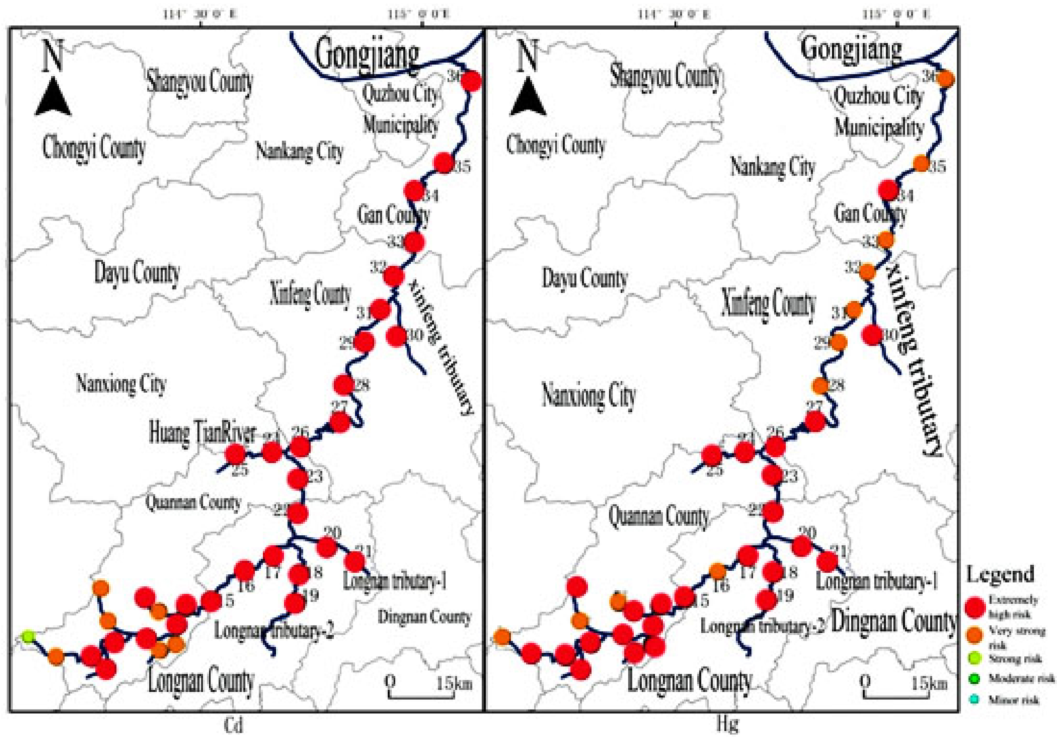
Distribution of Eri ecological risk degree of Cd and Hg in sediments.
Discussion
There are a few investigations on the current situation and distribution characteristics of heavy metal pollution in the sediments of rivers in the southern Jiangxi W mine area in China; so, this study's investigation was based on Taojiang River sediments. According to the results, affected by mining activities, seasonal rainfall, and human activities, the content of heavy metals in sediment presents a significant spatiotemporal difference. The sedimentary heavy metals are released or enriched with changes in the hydrological environment. Heavy metals are easier to release and difficult to deposit after heavy rainfall and subsequent water disturbance, and thus, the heavy metal content decreases during the high-water period, but seasonal rains increase surface runoff and become another source of heavy metal pollution in the high-water period (Swarnalatha et al., 2014; Song et al., 2015b). Due to the influence of rainfall, heavy metals are washed into rivers and accumulate in sediments through the physical and chemical process, and the self-purification capacity of water is consequently weak in the low-water period (Hu et al., 2010; Yang et al., 2012), which lead to the increase of heavy metal content in this period. Comparing the low-water and high-water periods, the river flow actually did not change much and the heavy metal content in the sediment was stable. Human industrial and agricultural activities are also key factors that explain the large spatial distribution of heavy metals such as W, Cd, As, and Cu in sediments (Huang et al., 2016). Influenced by the Dajishan tungsten mining, the content of W in sediments was 23 times (high-water period), 16.8 times (normal-water period), and 90.9 times (low-water period) higher than the background value at the Taojiang River source (4.42 mg/kg) during the same three hydrological periods. Site 5, downstream of the mining area, is 16.5 times higher than the background value in the high-water period, 11.3 times in the normal-water period, and 26.9 times in the low-water period. The sedimentary contents of As, Cr, Zn, Cu, and Pb all exceeded the background values between two and six times. Overall, the sedimentary heavy metal content gradually decreased with distance from the mining area. Citrus planting (Jiang et al., 2010), sewage discharge (Klaudia et al., 2016), and livestock excrement (Bian et al., 2017) are also important sources of Cd, Cu, and Zn. In areas affected by fruit planting, the W content in the sediment was between one and five times higher than the background value, and the content of the other heavy metals was between one and six times higher than the background value. In the sampling sites influenced by urban areas, Pb content is about seven times higher than the background value, and the other heavy metals are about two times higher than the background value. Affected by REEs, the content of As and W is about three times higher than the background value, and the content of other heavy metals is about two times higher than the background value. This study of the heavy metal pollution over three hydrological periods showed little change, but indicated that the sediment heavy metal content was mainly affected by mining, urban life, agriculture, and other human activities. W, Hg, and Zn were the common main environmental impact factors, and the study also found that although Zn is present in farmland soil (Gray et al., 1999), the contribution of Zn in the river sediments mainly comes from welding factories and automobile exhaust (Singh et al., 2017). Hg is mainly derived from atmospheric dust fall, followed by organic fertilizers and irrigation wastewater (Li et al., 2016).
Most of the sampling sites in the study area are located in the fruit-growing areas and living areas, which are greatly influenced by agriculture and urban life activities, however, those actives had a small impact on sedimentary Hg. W mainly comes from W mining, and it is concluded that without artificial control measures, the regional characteristics of pollutants and long-term accumulation will potentially lead to persistence of river water environment pollution. Therefore, clear sewage outlet should be set in the mining process to control the discharge of pollutants from the source, and the treatment of agricultural planting and urban sewage discharge in the surveyed area should also be carried out simultaneously. In addition, local government and environmental monitoring departments should strengthen management and regular monitoring.
Conclusion
Helpful tools and methods such as Eri, RI, and PCA were used to assess pollutions from eight heavy metals and to identify the possible sources of heavy metal contamination in Taojiang River sediments. This study showed that the eight heavy metals exhibited highest concentrations at low-water period, followed by the normal-water period and then the high-water period. Spatially, heavy metal content is higher in Huangtian River to Longnan section, Longnan tributary, and Xiaomu and Tianzhai Rivers. As a result of W mining activities, the sedimentary content of W downstream of the mine exceeded the soil background value of Jiangxi Province. According to PCA, the common major environmental impact factors during the three hydrological periods were W, Hg, and Zn. The mean value of each heavy metal's Eri was Cd>Hg>Cu>W>Zn>As>Pb>Cr, and the main potential ecological risk factors were Cd and Hg in Taojiang River sediment, while other heavy metal concentrations were relatively safe.
Footnotes
Acknowledgments
We thank Kara Bogus, PhD, from Liwen Bianji (Edanz Group China) (www.liwenbianji.cn/ac) for editing the English text of a draft of this article. We thank Mingshu Li, PhD, from Jiangxi Academy of Environmental Sciences, Nanchang (![]() ) for critically reading and revising the article.
) for critically reading and revising the article.
Author Disclosure Statement
No competing financial interests exist.
Funding Information
This research was supported by the National Natural Science Foundation of China (Nos. 51664025, 41861002, and 31460130), the Key R&D Project of Jiangxi, China (No. 20171ACG70019), and the Natural Science Foundation of Jiangxi Province (20181BAB203026).