




Abstract
To quantitatively calculate the spatiotemporal differences in the effect of the water supply from the Three Gorges Reservoir, three typical falling modes were proposed: falling in advance, uniform falling, and falling at a high water level. Based on a one-dimensional and two-dimensional model coupled hydrodynamic model, the spatial and temporal distributions of the Dongting Lake water level were compared with the ecological water level, which was assessed using a hydrological method, and the power generation of the Three Gorges Hydropower station under different scenarios was also analyzed. The results showed that the water supply effect of the falling in advance and falling at high water level scenarios on the Dongting Lake water level exhibited obvious spatial and temporal heterogeneity, but the effects were mainly concentrated in the northern part of eastern Dongting Lake, whereas limited effects were observed for the southern and western Dongting Lake. In scenario 1 (falling in advance), the water level at Chenglingji increased by 0.12 m on average and power generation was reduced by 0.30%. In scenario 3 (falling at a high water level), the water level at Chenglingji decreased by 0.09 m on average; and power generation increased by 0.28%.
Introduction
Dongting Lake is one of the two largest freshwater lakes in China and lies in the middle and lower reaches of the Yangtze River, northern Hunan Province (Hu et al., 2018). The Lake inflow sources are mainly composed of the “Four Rivers” (i.e., Xiangjiang River, Zisui River, Yuanjiang River, and Lishui River) and the “Three Diversions” from the Yangtze River (i.e., Songzikou, Ouchikou, and Taipingkou), which then flow into the Yangtze River at the Chenglingji hydrological station (Fig. 1). The wetland of the lake plays a pivotal role in regulating the hydrological process of the Yangtze River, and the wetland of Dongting Lake is a high-quality habitat for rare and endangered migratory birds, fish, and mammals, forming an essential ecosystem with more than 1,300 plant species (Li et al., 2016; Zhan et al., 2017).
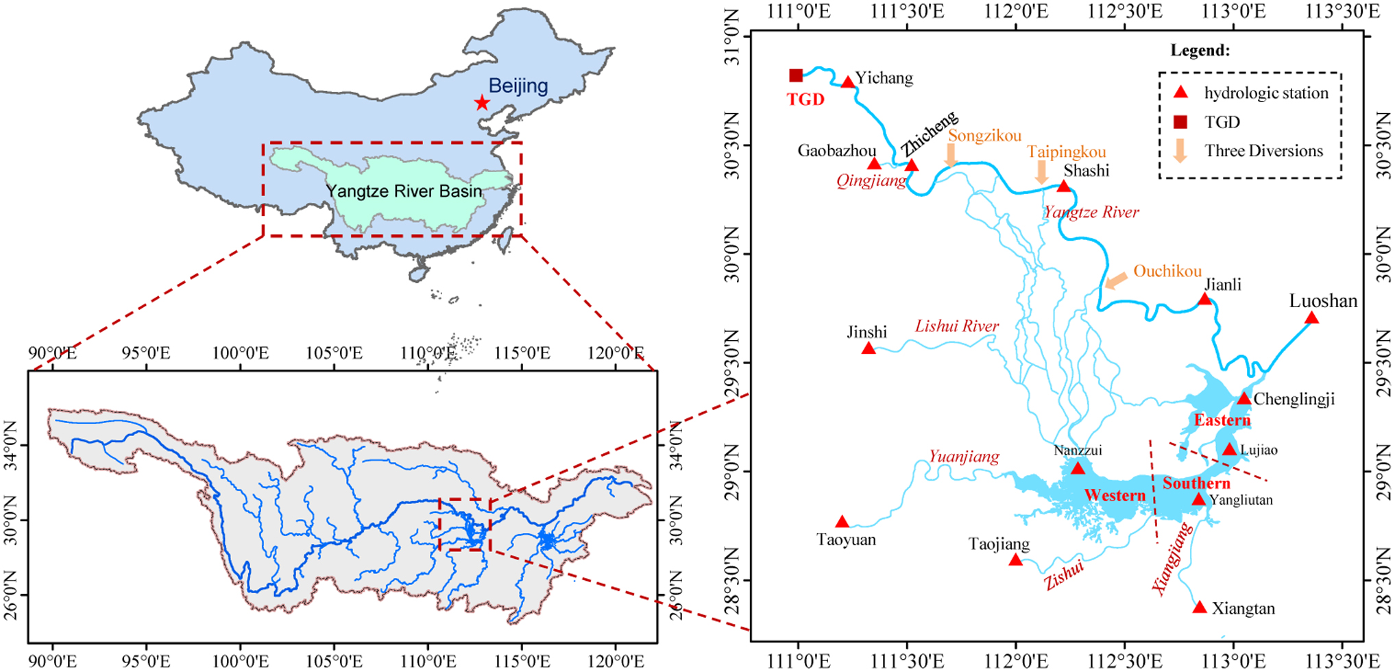
Locations of Dongting Lake, TGD, and the Yangtze River. TGD, Three Gorges Dam.
However, since the beginning of the 21st century, the lack of rainfall in the lake basin and the severe riverbed erosion in the Yangtze River have caused the Dongting Lake water level to consistently fall below the historical record (Han et al., 2018). Furthermore, the duration of the low water level has increased by ∼30% (Cheng et al., 2018), which directly affects migratory birds that rely on the wetlands as their main habitat (Avery and Tebbs, 2018). In addition, the flow velocity of the lake has slowed due to the decline of the water level (Dai et al., 2018; Xu et al., 2018), which has weakened the water exchange between the lake and the Yangtze River, decreasing the self-purification capacity of the water body (Baustian et al., 2018). The main pollution indicators in the lake, that is, total nitrogen (TN) and CODMn, have shown rapid growth trends, exacerbating the water pollution and deterioration of the water environment (Liu et al., 2018; Zhu and Yang, 2018). The seasonal water shortages in the lake will greatly restrict the ecological water availability and the human water supply in the lake as well as the Yangtze River (Tian et al., 2017). Along with potential flood disasters, the water scarcity issue has become increasingly important and will affect the lake water ecological environment and local residents. Therefore, taking effective measures to avoid extreme low water levels in the lake is a high priority (Ren et al., 2018).
To maintain the appropriate lake water level during the dry season, engineering measures and nonengineering measures may be adopted (Dai et al., 2017). Engineering measures include constructing sluice gates at the Three Diversions and the lake mouth; however, such measures may have adverse ecological impacts, and fierce debate is ongoing regarding whether such measures should be taken. Currently, nonengineering measures, such as supplying water to Dongting Lake by reservoir optimization, are highly valued by various parties.
The Three Gorges Reservoir (TGR) is the largest reservoir in China. The TGR is operated at a normal water level of 175.0 m during the dry season and a flood control level of 145.0 m during the flood season to reserve enough volume to store possible floodwaters (Wang et al., 2016; Jin et al., 2019). Dongting Lake is the first river-connected lake downstream of the TGR, ∼400 km from the dam. To fully exploit the water supply benefits of the TGR, water is supplied to the downstream and Dongting Lake by adjusting the falling mode of the reservoir. For example, on February 19, 2014, the release from the TGR increased by 1,550 m3/s relative to the regular release, and the Chenglingji water level increased by 1.43 m. Thus, optimizing the reservoir falling modes can improve the water level of Dongting Lake; however, due to the topography and inflow difference of the lake, the water supply effect from the TGR has spatial and temporal differences. Moreover, changing the falling mode may decrease the power generation, which is a concern for hydropower station managers. Therefore, accurate analyses of the effects of the water supply strategy on Dongting Lake and power generation are required to determine an appropriate falling mode for the reservoir.
Most of the research on the TGR water supply has focused on the mainstream of the Yangtze River, as well as power generation, ecological flows, and shipping (Feng et al., 2018; Yang et al., 2018). However, the effects of different falling modes of the TGR on Dongting Lake require further quantitative evaluation during the dry season. Therefore, based on the falling mode of the TGR since the reservoir began normal operations in 2010, this article proposes three typical falling modes and quantifies the spatial distribution of the water supply effect on Dongting Lake using an integrated one-dimensional and two-dimensional model (1D–2D) coupled hydrodynamic model. In addition, the effects of the different falling modes on power generation are investigated.
Materials and Methods
Study area
Dongting Lake (27°39′-29°51′ N, 111°19′-113°34′ E) is located on the south bank of the middle reaches of the Yangtze River, ∼400 km downstream of the Three Gorges Dam (TGD), and it is also one of the most famous freshwater lakes in the world (Lu et al., 2018). The lake area is 2,820 km2 when the water level at the Chenglingji hydrological station is 30.80 m. The lake mainly gathers water from the Yangtze River through the Three Diversions and Four Rivers of the lake basin. In general, Dongting Lake is divided into three parts: the eastern, southern, and western lake areas (Fig. 1). The water from the Three Diversions mainly flows into the western lake area. The Xiangjiang and Zishui Rivers flow into southern Dongting Lake, while the Yuanjiang and Lishui Rivers flow into western Dongting Lake. After regulation, all of the water flows back into the Yangtze River through the sole outlet of Dongting Lake at Chenglingji station.
In this study, the daily average flow, water level, and topographic data of Dongting Lake were collected from the Yangtze River Water Resource Commission. The inflow, outflow, and water level data of the TGR were obtained from the Three Gorges Corporation. The data series is complete and consistent, and they cover the period from 1953 to 2019. The homogeneity and reliability of the data were strictly controlled and checked before their release.
Coupled hydrodynamic model
To quantitatively evaluate the spatiotemporal distribution of the effect of the water supply on Dongting Lake under different typical falling modes of the TGR during the dry season, a 1D–2D coupled hydrodynamic model was established.
The model describes the watercourse topography in the form of unstructured grids and adopts the alternation direction implicit line method for the space-time integral of quality and momentum equations. In this model, the vertical average flow factor was selected as the research object to realize the simulated computation of the flow velocity and water level in a 2D flow field. According to the requirements of the hydrodynamic simulation process, the 1D model presupposes the operation rule to control the water yield of rivers. The 1D–2D coupled model first obtains dynamic coupling computations for the flow field of the 2D model as well as the gate functions of the 1D model, and then, it obtains the information of each grid cell node in the 2D watercourse controlled by gate (Jamali et al., 2018; Zhang et al., 2020).
The 1D model was used to simulate the Yangtze River mainstream (from the TGD to Luoshan hydrological station), the Three Diversions, and the Four Rivers (from the control hydrological station of the Four Rivers to the lake area). Considering the length and complexity of the river, to accurately reflect the longitudinal changes, the distance between two adjacent river sections was 5–10 km. The 2D model was used to simulate Dongting Lake and the river-lake intersection area. Since a triangular mesh can accurately describe the lake shoreline conditions of the calculation region, the model used an unstructured triangular mesh. The mesh size was determined based on the spatial distribution of the topography. According to the above principles and considering the calculation time, the total number of Dongting Lake nodes was 9,424 and the total number of units was 14,289. In addition, the longest side of the grid was 1,396 m and the shortest side was 119 m (Fig. 2).
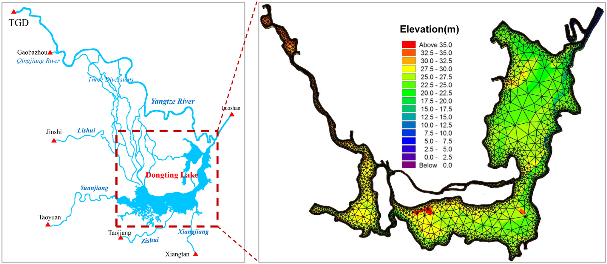
Boundaries of the coupled hydrodynamic model and 2D-computational element. 2D, two dimensional.
The boundary conditions include hydrological boundaries and topographical boundaries. The hydrological boundaries include the daily average outflow from the TGR, the discharge of the Qingjiang River (Gaobazhou station), and the discharge at the control hydrological stations on the Four Rivers (Xiangtan, Taojiang, Taoyuan, and Jinshi stations). The downstream boundary conditions include the water level-discharge relationship curve at the Luoshan hydrological station (Fig. 2). The topographical boundaries are based on the bathymetric data of the rivers and lake in 2015.
Model calibration and validation are necessary to control the model accuracy within a reasonable level. We selected the Manning coefficient (n) as the parameter for calibration, and it has been verified to be effective for the output results. To quantitatively evaluate the simulation results, the determination coefficient (R2) and Nash-Sutcliffe efficiency coefficient (NSE) were selected. The NSE is an index used to evaluate the model accuracy, and the specific formula is as follows:
where NSE is the Nash-Sutcliffe efficiency coefficient,
The year 2017 was selected for model calibration and validation because the corresponding boundary condition data, including the time series of water level and discharge data, provided the best coverage. The 9-month period from January to September was used for calibration, and the following 3 months were used for validation. The observed data and simulated results were compared at four hydrological stations along the Yangtze River and four hydrological stations on Dongting Lake. The Manning coefficient was the key parameter used to adjust the accuracy of the model between the observed and simulated data. The results showed that the calibration results spanned an acceptable range of Manning coefficients, which varied from 0.019 to 0.045. Based on the distribution of the Manning coefficients, there were significant errors between different reaches. The Manning coefficients in the straight river reaches with smooth riverbeds were much smaller than those of curved river reaches with large shoals and deep pools.
The calibration and validation results are shown in Fig. 3. The observed and simulated water levels exhibited good agreement at the majority of hydrological stations. The simulated water levels at eight hydrological stations were close to the observed levels, and the absolute value of the difference was <0.32 m. In the calibration, the NSE of the water level was 0.876, and the determination coefficient (R2) was 0.954. In the validation, the NSE of the water level was 0.870, and the correlation coefficient R2 was 0.942.
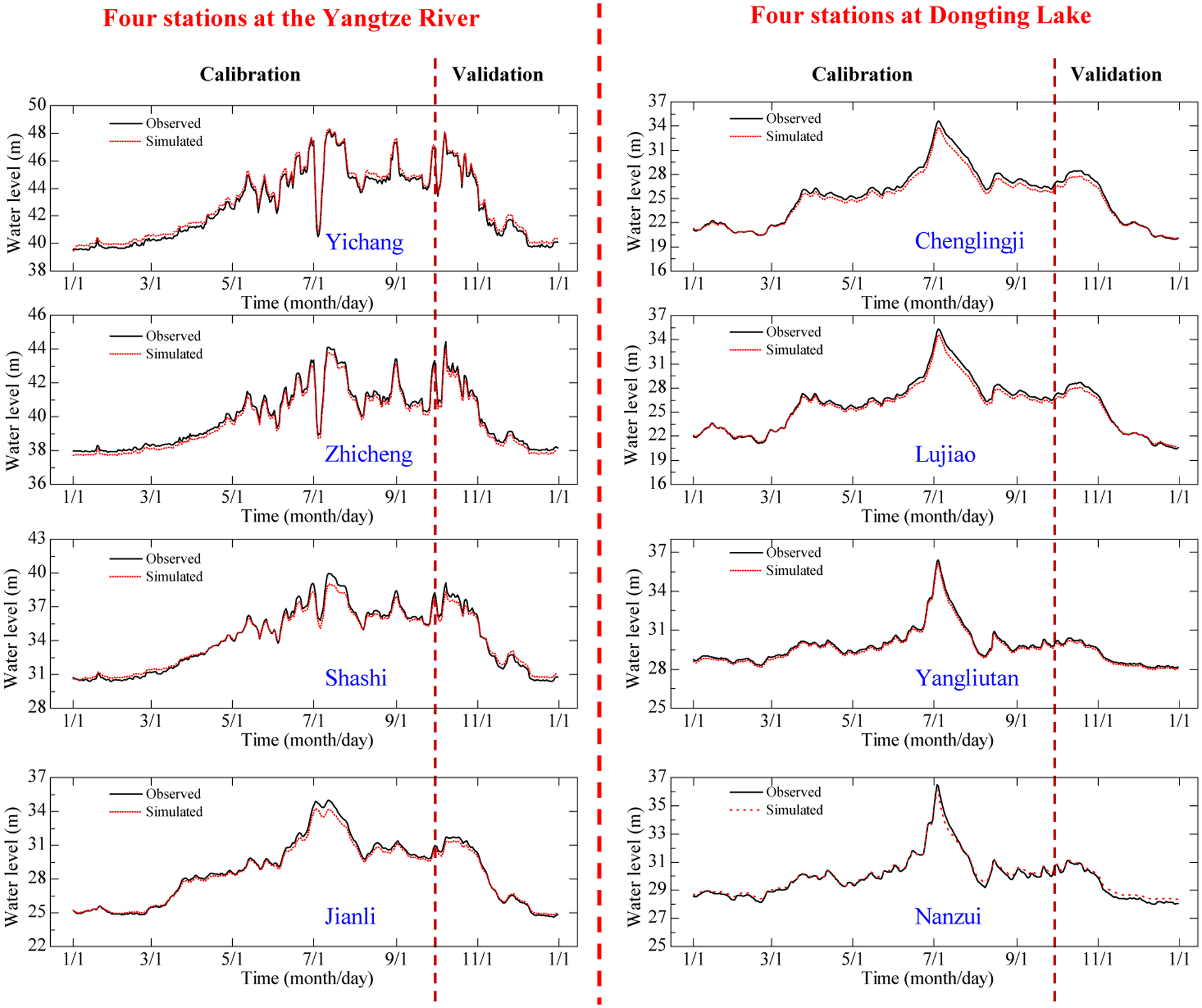
Observed and simulated water levels of the Yangtze River and Dongting Lake.
Scenario design
The different falling modes of the TGR directly affect the outflow from the reservoir, which in turn affects the effect of the water supply on Dongting Lake. According to the optimal operation plan, the TGR is a comprehensive large water conservancy project for flood control, power generation, navigation, and water resource utilization, and the normal water level is 175.0 m, the lowest water level during the dry season is 155.0 m, and the flood control level is 145.0 m. There are four continuous periods within a complete operation cycle. The first period is the impoundment stage, in which the TGR begins to impound water from September to October; and the reservoir water level rises from 145.0 to 175.0 m. The second period is the dry and falling stage, in which the outflow from the TGR is increased to meet the downstream water demand during the dry season from November to April, especially from January to March, and the reservoir water level declines from 175.0 to 155.0 m. The third period is the predischarge stage, in which the water in the reservoir is emptied from May to June, and the reservoir water level declines from 155.0 to 145.0 m. The fourth period is the flood stage, in which water is discharged downstream during the period from July to August (Fig. 4).
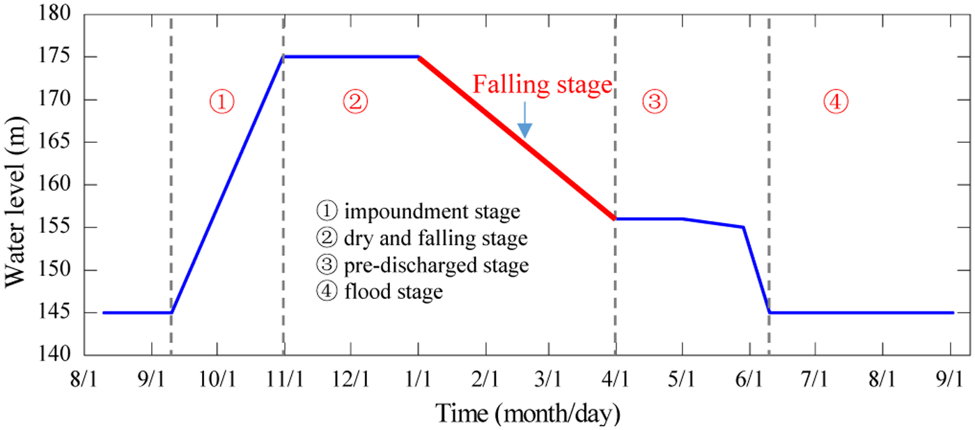
Four stages in the regular operation of the TGR. TGR, Three Gorges Reservoir.
The period from January 1 to March 31 is called the falling stage. The ecological environment of Dongting Lake is extremely sensitive to water level fluctuations during this period. During regular operations, the reservoir water level falls from 175.0 to 155.0 m. The goal of water resource utilization for the TGR is to increase the minimum outflow to meet the discharge requirements for power generation and shipping demands; therefore, the investigated study period is concentrated from January to March.
On October 26, 2010, the TGR successfully stored water at the normal water level of 175.0 m for the first time. By October 30, 2019, the reservoir water level continuously reached a normal level for 10 years, which provided a solid foundation for water supply benefits during the dry season.
According to the “Optimal operation plan for the Three Gorges Reservoir” issued by the Ministry of Water Resources of the People's Republic of China, the TGR implements navigation and water supply to the lower reaches of the Yangtze River during the dry season. According to the actual falling mode of the TGR from 2010 to 2019, the water level range of the reservoir in early January is 171.0–175.0 m, while that in late March is 161.0–167.0 m. Therefore, according to the initial reservoir water level of the predischarged stage, we set three typical scenarios of falling modes (Fig. 5). To ensure the stability of the reservoir slope, the water level drop rate of the reservoir is controlled within 0.60 m/day.
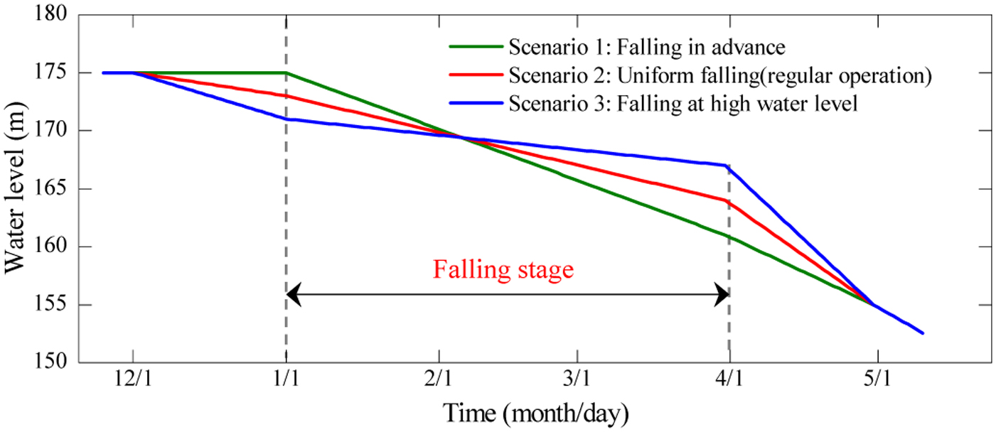
Typical falling modes of the TGR during the dry season.
Scenario 1: falling in advance
In this scenario, the water level reaches the lowest level at the beginning of the predischarged stage. From December 1 to January 1, the water level of the reservoir remains at 175.0 m, after which the water level uniformly declines by 0.156 m/day; on March 31, the water level has decreased to 161.0 m, after which it uniformly declines by 0.200 m/day until April 30, when the water level reaches 155.0 m.
Scenario 2: uniform falling (regular operation)
In this scenario, the water level is controlled according to a moderate water level at the beginning of the predischarged stage. On December 1, the water level is 175.0 m. Then, the water level uniformly declines at 0.065 m/day reaching to 173.0 m on January 1. A falling rate of 0.122 m/day is applied until the end of March, when the water level is 164.0 m. Then, the water level drops at 0.300 m/day. By April 30, the water level decreases to 155.0 m.
Scenario 3: falling at a high water level
In this scenario, the water level of the reservoir is 175.0 m on December 1, after which it uniformly declines by 0.129 m/day. The water level is 171.0 m on January 1 and then drops at 0.100 m/day. At the beginning of the predischarged stage, the water level is controlled at the highest water level of 167.0 m and then drops uniformly at 0.4 m/day to 155.0 m on April 30.
Ecological Water Level of Dongting Lake
The water level plays an important role in maintaining the diversity of lake ecosystems (Carmignani and Roy, 2017). The ecological water level (EWL) of a lake is the optimal water level for maintaining lake habitats and improving ecological quality (Mettrop et al., 2015; Feng et al., 2019). Therefore, maintaining the EWL is the top priority for protecting the Dongting Lake ecosystem, and a thorough understanding of the lake EWL is useful for optimizing the water replenishment operation of the reservoir.
Considering the spatial variability across the lake, EWLs are considered for the eastern, southern, and western lake regions (Liang et al., 2018). The water resource availability of different lake regions may be approximately reflected by the water levels of their own representative gauging stations: Lujiao for the eastern region, Yangliutan for the southern region, and Nanzui for the western region. In addition, the Chenglingji station is the intersection of the river-lake system, and the water level at Chenglingji is an important indicator of the water conditions of the rivers and lake; therefore, we selected Chenglingji and the other three stations within the lake (Lujiao, Yangliutan, and Nanzui) as the representative hydrological stations.
Since the 1960s, the methods used for calculating the EWLs of lakes, rivers, and wetland ecosystems have evolved (Nilsalab and Gheewala, 2019). Recently, three types of representative methods, including hydrological methods, hydraulic rating methods, and habitat simulation, have been used to calculate the EWLs. The hydrological method is used to estimate EWLs because it measures hydrological alteration based on historical hydrological data. The hydrological method was used in this study. First, we collected long time sequences (from 1953 to 2002) of the 10-day average water level from four representative hydrological stations (Chenglingji, Lujiao, Yangliutan, and Nanzui) (Fig. 1). The frequency of occurrence of the different water levels was then determined by plotting a histogram of the water level. Based on the 10-day average water level data from 1953 to 2002, the water levels for every year were ranked in descending order, and the water levels ranked between the top 25% and 75% are a suitable range of the EWL. Next, we analyzed the relationship between the water level and the corresponding ecological information parameters to determine the required water level. Since the number of migratory birds in the dry season is an important manifestation of the ecological indicators of Dongting Lake, we chose the number of the migratory birds as an ecological variable (Fig. 6). When the water level with the best ecological parameters appeared in the histogram, we treated that water level as the EWL. The EWLs are shown in Table 1.
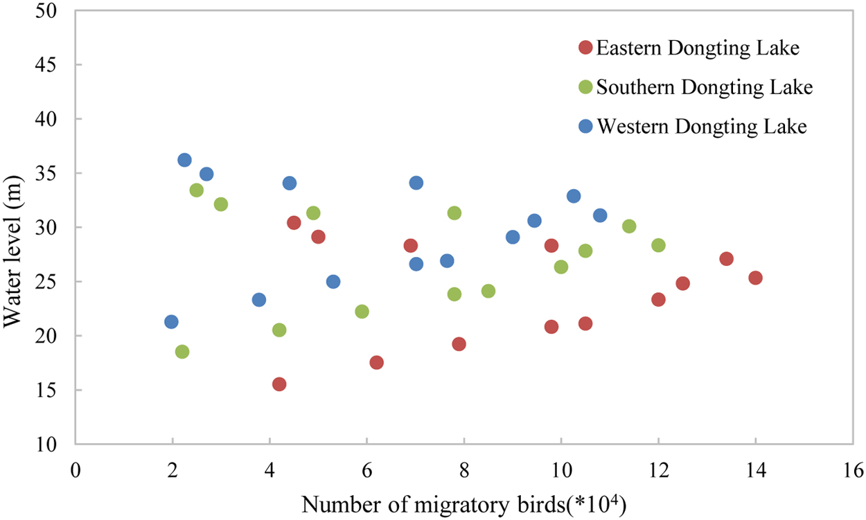
Number of migratory birds in different parts.
Ecological Water Levels of Dongting Lake (m)
Results and Discussion
Spatiotemporal variation in the water level in Dongting Lake
In this study, because the actual water level can meet the EWL in wet and normal hydrological years, we focus on the water supply effect in dry years based on the long-term daily flow data from the Yichang hydrological station and the control hydrological stations on the Four Rivers from 1953 to 2002 (Fig. 1). Flow frequency curves are drawn according to the inflow series. The flows below a frequency of 25% are classified as wet hydrological years, and those higher than 75% are considered dry hydrological years, while other years represent normal hydrological conditions. Based on the above method, the year 1978 was selected as a dry year. The reservoir outflow of the different falling modes was calculated according to the reservoir water balance principle when the reservoir inflows were known as shown in Fig. 7.

Inflow and outflow from the TGR under different scenarios.
The outflows from the TGR, Qingjiang River, and Four Rivers were used as the upstream boundary conditions of the coupled model, and the water level-flow relationship curve at Luoshan hydrological station was used for the downstream boundary condition. Considering the stability and computational efficiency of the model, the time step of the 1D model was set to 30 s, the maximum calculation step of the 2D model was 5 s, and the minimum calculation step was 0.1 s. The time step was automatically adjusted based on water flow information and topography.
The influence of the outflow from the TGR on the Dongting Lake water level is mainly reflected in two aspects. The first is the increase or decrease in the fractional discharge entering western Dongting Lake through the Three Diversions. The second is the increase or decrease of the water level at Chenglingji hydrological station, which is located at the intersection of Dongting Lake and the Yangtze River, and then jacking or emptying the water from the lake. However, during the dry season, Taipingkou and Ouchikou are basically cut off, and the fractional flow from Songzikou is small; therefore, the influence of the TGR on Dongting Lake mainly increases or decreases the water level at Chenglingji hydrological station.
The water level variations at Chenglingji and the other three representative hydrological stations under different scenarios are shown in Fig. 8. Obvious spatial and temporal differences are observed in the water supply effect from January to March. When the outflow from the TGR is increased to replenish water to Dongting Lake, the water level at Chenglingji increased slightly, while the inner lake area of Dongting Lake is not affected.
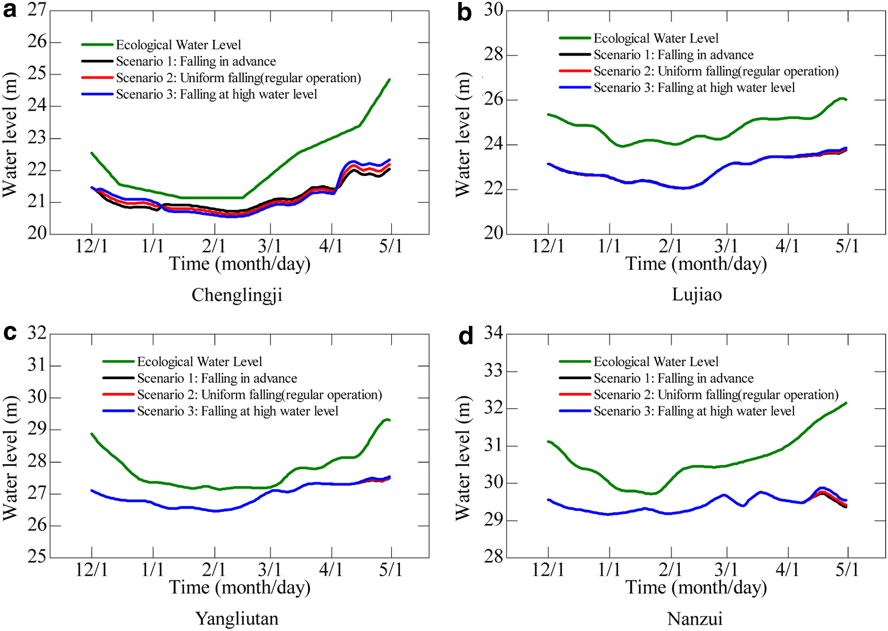
Water level time series at four representative hydrological stations.
Scenario 1 yielded the highest reservoir water level drop rate, and the average outflow from the TGR from January to March was 560.59 m3/s higher than that for scenario 2 (regular operation). The water level at Chenglingji increased by an average of 0.12 m, and the minimum and maximum increases were 0.048 and 0.145 m, respectively. However, limited effects were observed for the other parts of Dongting Lake, including the southern part of the eastern lake and southern and western parts of the lake. The water level of Lujiao station only increases 0.02 m, and the increases at Yangliutan and Nanzui stations are 0.0 m. The reason is that the water level throughout Dongting Lake was very low during this period, and the topography slopes from southwest to northeast. Along with the increased discharge of the Yangtze and Four Rivers, the lake water level was raised step by step in April; thus, increasing the outflow from the TGR can affect the water supply effect throughout Dongting Lake. At the end of April, the water levels at Chenglingji, Lujiao, Yangliutan, and Nanzui increased by 0.16, 0.06, 0.03, and 0.12, respectively.
In scenario 3, to maintain a higher water level in the reservoir, the average outflow was reduced by 573.94 m3/s compared to that in scenario 2. The effect on the Dongting Lake water level was mainly concentrated in the northern part of eastern Dongting Lake. The water level at Chenglingji decreased by 0.09 m on average, and the minimum and maximum decreases were 0.045 and 0.112 m, respectively. However, the water levels at the other sites on Dongting Lake were less affected. At the end of April, decreasing the outflow from the TGR can affect the water level throughout the entire lake, and the water levels at Chenglingji, Lujiao, Yangliutan, and Nanzui decreased by 0.11, 0.03, 0.01, and 0.06 m, respectively.
Figure 8 also shows that although the water level of Dongting Lake has increased slightly, due to the low water level of Dongting Lake during the dry season and the water being mainly concentrated in the northern part of eastern Dongting Lake, the impact of the increased discharge of the TGR on the water level is mainly concentrated in the northern part of Eastern Dongting Lake. From the simulation results, the water level of the Lujiao station only increases by 0.02 m., The increases in the water levels of other stations, including Yangliutan in Southern Dongting Lake and Nanzui in Western Dongting Lake are 0.0 m, so and thus, the effect of the water supply through the TGR is very limited compared with the EWL.
To accurately evaluate the effects of different falling modes of the TGR on the EWL, Equation (2) is used to calculate the satisfaction rate of the EWL as follows:
where SR is the satisfaction rate of the EWL,
The satisfaction rate of different scenarios is shown in Fig. 9. It can also be seen from the figure that when the water level of Dongting Lake is low (before April 1), the effect of the water supply of the TGR is limited to the northern part of Eastern Dongting Lake. After April 1, as the lake water level increases, the scope of the water supply gradually affects the whole lake.
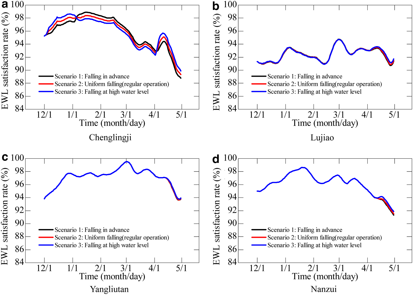
Satisfaction rate of the EWL. EWL, ecological water level.
Figure 10 shows the 2D water depth differences of Dongting Lake during the dry season. Due to the small flow of the Yangtze River and the Four Rivers during the dry season, the water depth of the entire lake is very shallow, with water mainly occurring in narrow lake troughs. The water depth at Chenglingji is 6.00 m in mid-January, ∼5.85 m in mid-February, and ∼6.47 m in mid-March.

Spatial and temporal variation in the Dongting Lake water depth during the dry season:
Compared to scenario 2, the TGR increases the outflow in scenario 1 and the influence of the increased discharge flow from the TGR on the Dongting Lake water depth is mainly concentrated in the northern part of eastern Dongting Lake. In January, the water level increased by 0–0.16 m; in February, the water level increased by 0–0.06 m; and in March, the water level increased by 0–0.07 m.
Compared to scenario 2, the TGR decreases the outflow in scenario 3, and the decline of the water depth in Dongting Lake is mainly concentrated at the exit of the lake around Chenglingji hydrological station. In January, the water level decreased by 0.04–0.06 m; in February, the water level decreased by 0.03–0.05 m; and in March, the water level decreased by 0.04–0.08 m.
Effect on power generation
Although hydropower causes some environmental problems (Zarfl et al., 2015), compared with traditional energy, hydropower is one of the less expensive and environmentally clean energy options (Daneshvar et al., 2020; Hatamkhani et al., 2020). Power generation is a main function of the Three Gorges Hydropower Station. In pursuit of maximizing power generation, hydropower stations are operated under the maximum constraint of power generation, and such operations are the responsibility of hydropower station operators. However, different falling modes may change the power generation, which in turn affects the economic benefits of the reservoir. Therefore, it is necessary to quantitatively evaluate the effect of different falling modes on power generation. To facilitate the consistency of each scheme, the power generation calculation period was from December 1 to April 30 of the following year. The formula for determining the power generation is as follows:
where E is the power generation, A is the comprehensive output coefficient of the power station, Qt is the flow through the generator,
The power generation in different scenarios is shown in Table 2. Different falling modes have various effects on the power generation at the Three Gorges Hydropower Station. In scenario 1 (falling in advance), the reservoir water level is lower than that in scenario 2, and power generation is reduced by 75 million kW·h, or 0.30%. In addition, the reservoir water level in scenario 3 is always higher than that in scenario 2, and power generation is the highest, with an increase of 0.07 billion kW·h, or 0.28%, over that in scenario 2.
Comparison of Power Generation in Different Scenarios (Billion kW·h)
Conclusions
To quantitatively analyze the effects of the water supply from the TGR on Dongting Lake in different falling modes, a 1D–2D coupled hydrodynamic model covering the main stream of the Yangtze River, Dongting Lake, and the lake tributaries was constructed. Due to the topography and water flow conditions of the lake, the overall water level in the dry season is low. The effects of increased or decreased discharge from the TGR on Dongting Lake are mainly concentrated in the northern part of eastern Dongting Lake; however, the water levels at the other sites on Dongting Lake were less affected. There is a mutually restrictive relationship between water supply and power generation. Falling in advance can increase the water level at Chenglingji by an average of 0.12 m, while decreasing power generation by only 0.30%. The falling at a high water level scenario can be used to reduce the Chenglingji water level by an average of 0.09 m and increase power generation by 0.28%. Therefore, to better meet the EWL requirements, power generation must be decreased and a balance must be obtained.
Footnotes
Author Disclosure Statement
No competing financial interests exist.
Funding Information
This work was supported by the Changjiang River Scientific Research Institute (CRSRI) open research program (grant numbers: Program CKWV2019725/KY), the National Natural Science Foundation of China (grant numbers: 51809150), China Postdoctoral Science Foundation (grant numbers: 2019T120119, 2020M670391).