




Abstract
Recent land use changes in the form of deforestation, agricultural development, industrialization, and urbanization have caused water quality and quantity problems in many watersheds in Vietnam necessitating the development of appropriate policy interventions. This research explores the possibility of using a coupled Geographic Information System and hydrological model (Soil and Water Assessment Tool [SWAT]) to assess the impact of land use changes on stream flows in the Thac Ba reservoir basin in the Northern Vietnam in three different land use change scenarios: expansion of forest lands, return to the nature, and expansion of the urban area. The Nash-Sutcliffe Efficiencies of 0.895 and 0.869 were obtained after the calibration and validation processes, respectively. The nutrient and sediment loadings are currently being assessed pending the acquisition of observed data and model calibration. Further studies will be conducted to have a look at the likely effects of climate changes on the water quality and quantity of the Thac Ba reservoir as well as providing an insight of how the SWAT model for the Thac Ba reservoir basin can be applied to the much larger and nationally more important basin, the HoaBinh reservoir basin which provides drinking water to the capital Hanoi. According to the scenarios of land use change conditions, an increasing trend in stream flow may be expected in the next decades caused by increasing rainfall amounts. Therefore, flooding and the reduced reservoir capacity are major problems in the target area, and there must be improvement of watershed management by applying the Integrated Lake Basin Management concept.
Introduction
Integrated Water Resource Management (IWRM) (Biswas et al., 2005) and Integrated River Basin Management (IRBM) or integrated watershed management, which is a subset of IWRM, has been widely adopted throughout the world for sustainable water management. Both IWRM and IRBM approaches require concerted efforts from relevant stakeholders involved in managing water resources. The lack of strong support and interagency collaboration in managing the available water resources, comprehensive policies, regulatory framework, and financial sustainability have caused failures or impeded the successful implementation of integrated management of water resources in these countries.
Integrated Lake Basin Management (ILBM) is a conceptual framework for assisting lake basin managers and stakeholders in achieving sustainable management of lakes and their basins (International Lake Environment Committee [ILEC], 2005). It is not just a simple application of IWRM or IRBM principles. ILBM promotes continuous improvement of lake basin governance by integrating institutions, policies, participation, technologies, information, and finance. It also focuses on ecosystem services, such as soil formation, food, habitat provision, and so on, provided by lakes and their basins. It assists lake basin managers and stakeholders in achieving sustainable management of lakes and their basins. According to an ILEC report (2010), ILBM supports sustainable use and conservation of water resources by the stake holders, individuals, and organizations with management responsibility for a particular lake basin. It has been developed over the past several years by ILEC as the basis for effective lake basin management. Conceptually, ILBM is founded on Lake Basin governance which consists of six elements: institutions, policies, participation, technologies, information, and finance. ILBM promotes continuous improvement of Lake Basin governance by integrating all of them and it also focuses on ecosystem services provided by lakes and their basins. The ILBM concept has been developed since early 2000 in many lakes and reservoirs in Japan (Lake Biwa); Lake Laguna, Lake Lanao, Rinconada Lakes in the Philippines; Lake Putrajaya, Lake Chini and Lake Bukit Merrah in Malaysia; Lakes Bhopal, Lake Hussain Sagar, Lake Pushkar, Lake Udasagar, and Ujjani Reservoir in India; Lake Phewa, Lake Rupa, Lake Begnas and other small lakes in Nepal; Lake Ladoga, Lake Chudskoe/Peipsi and Lake Illmen in Russia, Lake Chapala and the Rio Lerma Basin in Mexico, and so on.
The application of Geographic Information System (GIS) and mathematical models such as the Soil and Water Assessment Tool (SWAT) model for the ILBM can help by providing a means of integrating existing knowledge on physical, chemical, and biological processes with monitoring data in both space and time (Barbosa et al., 2007; Tang et al., 2019; Rossi et al., 2009 or Shrestha et al., 2020). Nowadays a lot of research is being done on watershed management using SWAT model in the world such as water quality and water quantity assessment, assess land use or climate change on flow and sediment, nutrient, and soil erosion as well. As for land use and climate change impacts on the water quality and quantity, Gustard et al. (1993); Jha et al. (2007); Tadele (2007); Stehr et al. (2007); Zhang et al. (2007); Mango et al. (2011), and many more applied the SWAT model to investigate the response of stream flow and sediment in Balquhidder catchments in United Kingdom; Hare River watershed, Southern Rift Valley Lakes Basin, Ethiopia; Vergara watershed in Ethiopia; and Luohe river watershed. The hydrological modeling within a GIS environment provides a useful framework for assessing actual and potential changes to important system parameters such as land use and climate. The use of simulation models provides details on water movements and the transport of materials. The impact assessment of land use changes leading to soil loss and changes in water quantity and quality is one of the most important topics for decision-makers, especially in watersheds in developing countries such as Vietnam. The rapid increase of population and economic growth further accelerate the need for various land uses within the watersheds. Understanding land use change in relationship to its driving factors provides the essential information for land use planning and sustainable management of resources (Verburg et al., 1999; Park et al., 2020).
About Vietnam stream networks, each river system or lakes/reservoirs has its own distinctive characteristics, thus environmental management approaches may vary greatly from one river basin to another, depending on socioeconomic conditions, land use, environmental factors, and their economic and ecological values. The Government of Vietnam has realized that watersheds play an important role in national development especially in areas with a high proportion of ethnic minority groups. The Red River Basin Organization (RRBO) was established in 2001. The role of the RBOs is unambiguously to serve as technical coordinating and advisory bodies to Ministry of Agriculture and Rural Development (MARD), “assessing planning alternatives, basic investigation projects, inventory, and assessment of water resources in the river basin; submitting follow-up recommendations and proposals to MARD and authorized state agencies.” Other missions include data exchange and management, coordination with other ministries and agencies, capacity building, and awareness rising (Hoanh, 2009).
In Vietnam, ILBM is a relatively new concept, and research has begun only recently. There are several ILBM projects that have been implemented or developed previously in Vietnam. According to Trang (2010), SaiGon-DongNai river system was studied based on the ILBM concept. This watershed plays an important role in socioeconomic development in Southern Vietnam and has many reservoirs along the river system with the purpose of supplying water, generating hydropower, controlling flood, and so on. In Vietnam, the SWAT model has begun to be widely applied in the flow and sediment calculations and impact of climate change to flow in some regions. Nguyen Duy Binh et al. (2009) used SWAT and web technology to assess soil erosion in Northwest Vietnam. Phan Dinh Binh et al. (2010) applied the SWAT in Song Cau catchment to analyze the impact of land use changes on runoff discharge and sediment yield, and make policy recommendations for decision-makers regarding the impacts of land use changes on runoff discharge and sediment yield. The SWAT model was also applied to evaluate the effect of the main input data of SWAT (land use, soil, human practices) to soil loss and water quality in Tri An reservoir, La Nga subwatershed. The results showed that the land use change and practices affected surface flow and sediment yield loading to Tri An reservoir. Son and Nhu (2009) applied SWAT to simulate stream flow in Ben Hai river basin in response to climate change scenarios. The results show that the hydrology of Ben Hai watershed is sensitive to climate change. Most recent are the work by Binh et al. (2020), detecting River Bank Detection from Landsat Satellite Data.
With the ability to effectively simulate the basin in many different scales, SWAT should be considered to research and apply further to solve environmental problems, and developed ILBM step by step in Vietnam today. This article develops a spatially distributed watershed model for the Thac Ba reservoir basin in the Northern Vietnam by using the SWAT, a GIS-based hydrologic model to assess conditions in an important watershed as well as to demonstrate the feasibility of watershed modeling in Vietnam.
SWAT is the acronym for Soil and Water Assessment Tool, a river basin, or watershed, scale model developed by the United States Department of Agriculture-Agricultural Research Service (Arnold et al., 2009). The SWAT model is a widely known tool that has been used in several cases worldwide. It is a continuous time model that operates on a daily time step to perform simulations over long-time period. Its objective is to predict the impact of management on water, sediment, and agricultural chemical yields in large complex watersheds over long period of time (Neitsch et al., 1999, 2009). To meet this objective, SWAT (i) is physically based on the land reformation processes; (ii) uses readily available inputs; (iii) is computationally efficient; and (iv) is continuous in time and capable of simulating long periods for computing the effects of management changes (Arnold et al., 2004). The hydrologic component of SWAT is based on the following water balance equation:

In Equation (1), SW t is the final soil water content (mm), SW0 is the water content available for plant uptake, defined as the initial soil water content minus the permanent wilting point water content (mm), t is time (day), R is rainfall (mm), Qsurf is surface runoff (mm), Ea is evapotranspiration (mm), and Qgw is the amount of return flow/base flow on day i (mm).
The SWAT makes use of standard hydrological equations to simulate flows. For the accurate implementation of these equations, detailed input data are needed such as a digital elevation model (DEM) of the watershed, soil and land use data, and weather data of the studied area. The importance of land uses in the operation of the model lies mainly in the computation of surface runoff with the help of the Soil Conservation Service curve (Arnold et al., 1999).
In this study, the baseline condition was defined to represent the Thac Ba Reservoir basin conditions corresponding to the approximate time frame of 1992–2003. Data sets used in the model include land use, soil, weather (rainfall), and hydrological data for each hydrological response unit (HRU; these are spatial units, not necessarily contiguous, that share common properties for land use, soil, and slope) were assigned the same management information. This article concentrates on the impact assessment of land use change on stream flow. Three land use change scenarios were examined, namely (S1) expansion of forest lands, (S2) returning to the nature, and (S3) expansion of urban areas.
Study Area and Experimental Setup
The Thac Ba reservoir basin or Chay River basin is located in the Northern Vietnam at 21°30′N to 23°10′N latitude and 104°00′E to 105°15′E longitude and Universal Transverse Mercator coordinate system zone 48N with an altitude between 22 and 2,399 m above the sea level, as being shown in Fig. 1. ThacBa Reservoir basin has a total area of 6,500 km2 ∼(1,920 km2 of this is located in China). It originates from Ha Tao and passes the western slope of the Tay Con Linh mountain range that has a peak height of 2,419 m, in the Hoang Su Phi district, Ha Giang province. The terrain's basin stretches away across the high mountains down to the low hill land in Northern Vietnam (Tachikawa et al., 2004; UNESCO, 2004).
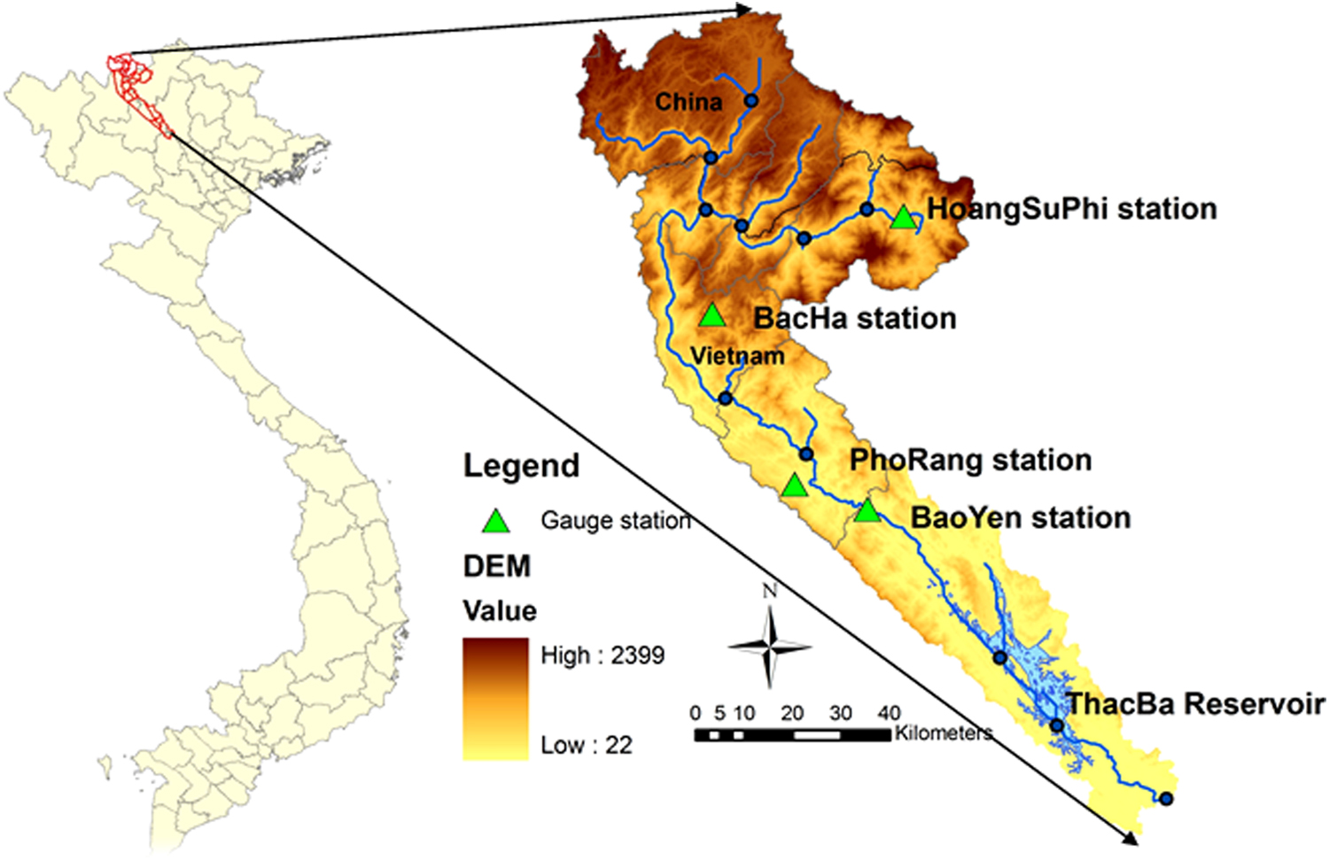
Thac Ba Reservoir basin (Chay River basin).
The Thac Ba reservoir is located in Yen Binh District Town, Yen Bai Province in Northern Vietnam. Thac Ba reservoir contains many islands and covers an area of 230.4 km2 with a watershed of 6,170 km2. The reservoir was created in 1970 by construction of a dam on the Chay River.
Data and model construction
The ArcGIS environment provides the tools for delineation, HRU definition, database editing, weather stations definition, inputs parameterization and editing, model running, and calibration of simulation results (Abraham et al., 2007). This GIS-based framework is convenient because all the information SWAT requires, including the weather, soil properties, topography, vegetation, and land management practices occurring in the watershed, has a geospatial component. A 90 m DEM from National Aeronautics and Space Administration was used to obtain the stream networks. The study area was delineated into six subbasins based on surface topography provided by the DEM with the relevant parameters of each subbasin calculated by ArcSWAT. Also, based on the land use and soil classes, the watershed was subdivided into 127 HRUs. To speed up the processing time, soil types and slope categories comprising <10% of the given HRU were assigned values for more dominant classes. Digital land use and soil data were obtained from Ministry of Natural Resources and Environment, Vietnam. Because of the limited climate data, only daily precipitation data for 1990–2003 period from three precipitation stations (Hoang Su Phi, Pho Rang, and Bac Ha stations; Fig. 1) were used as the input. The observed stream flow discharges at the Bao Yen gauge station (Fig. 1) were then compared with the simulated results for the calibration and validation procedures.
Model calibration and validation
The model was calibrated and validated for stream flows using the monthly data from 1992 to 2003 following the general procedure presented in the SWAT theoretical documentation and user manual (Neitsch et al., 2005). Data for the first 2 years (1990–1991) were used as the warm-up period for the model setup and the data of the period 1992–2003 were used for the calibration and validation. The evaluation of the model was carried out to determine whether the model is able to accurately represent the physical processes occurring in a watershed (Phomcha et al., 2011). The coefficient of determination (R2) and Nash-Sutcliffe efficiency (NSE) were used to evaluate the predictions of the model. If the NSE values are <0.5, the model prediction is considered unacceptable or poor. Values of 0.5 or greater (up to the maximum of 1) are considered as indicators for good model performance (Moriasi et al., 2007; Van Liew et al., 2007). The NSE is calculated as follows:
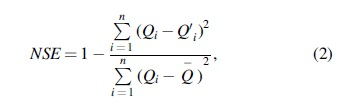
where NSE is the Nash-Sutcliffe coefficient, Qi is the observed discharge value (m3/s), Q′i is the simulated discharge value (m3/s), and
Land use change scenarios
The impact assessment of land use changes on stream flows by using the different land use change scenarios is of high relevance for the policy making process; therefore, three scenarios were created for the Thac Ba reservoir basin based on the socioeconomic and population trends (Skole and Tucker, 1993).
Scenario 1: Returning to the nature
In this scenario, all the lands in the watershed were converted to forest. This is unlikely to happen, but is able to test the model's behaviors/responses at some extreme bounds.
Scenario 2: Expansion of urban areas
In this scenario, most land use types in the watershed were converted to urban. Like Scenario 2, this is also unlikely to happen, but shows the effects of the extreme expansion of impervious areas.
Scenario 3: Expansion of forest lands
In this scenario, the forest land area was expanded by 18% by converting unused flat land to forest. The percentage of forest expansion was based on the decision 116/2006/QD-TTG by the Vietnam government to increase the percentage of forestation in local areas from 37.6% in 1999 to 58% in 2006.
Results and Discussion
Model calibration and validation
SWAT model was executed for a total simulation period of 13 years, which includes the period 1992–1997 as a calibration period and the period 1998–2003 as a validation period. The parameter adjustment was performed only during the calibration period. The validation process was performed by executing the model for the different time period (validation period) using the previously calibrated input parameters (Arnold et al., 2006). Observed flow data were available at the Bao Yen gauge station located upstream of the reservoir on the main river (Hao et al., 2004). The sources of inputs come from the database of Vietnam Institute of meteorology, hydrology, and climate change, Ministry of Natural Resources and Environment, in this area. The calibrated results are presented in Figs. 2–4.
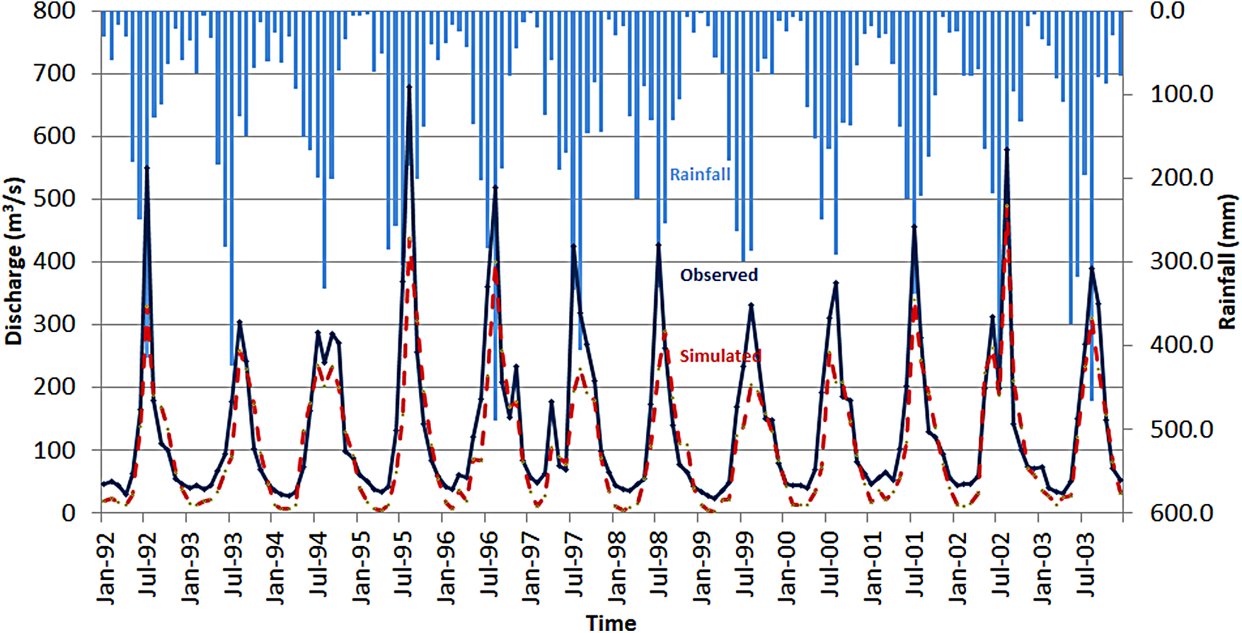
Comparison between monthly simulated and observed discharges at Bao Yen station or the period 1992–2003 (Model Precalibration).

Comparison between monthly simulated and observed discharges at Bao Yen station for the period 1992–1997 (Model Calibration).

Scatter plots of flow model at Bao Yen station for the period 1992–1997 (Model Calibration).
The results, including the most sensitive parameters for flows, Curve Number for moisture condition II (CN2), available water capacity of the soil layer (SOL_AWC)—(mm H2O/mm soil), groundwater delay time (GW_DELAY)—(days), baseflow alpha factor (Alpha_Bf), and threshold depths of water in the shallow aquifer for return flow to occur (GWQMN), are presented in Table 1, and the model evaluation for the calibration period is summarized in Table 2.
Parameter Values in Calibration Step
The Accuracy of Calibration for the Period 1992–1997
Based on the results obtained above, the model's parameters were adjusted so that the model predictions of stream flow matched better with the observed values at the Bao Yen station. A simulation for the validation period was then performed by using the results of the period 1998–2003 as shown in Figs. 5 and 6. The result implied that the simulated monthly flow was in close agreement with the observed flow values in the validation period. The model evaluation for the validation period using the same indices as the calibration period is presented in Table 3 (Hijmans et al., 2005).

Comparison between monthly simulated and observed discharges at the Bao Yen station for the period 1998–2003 (Model Validation).

Scatter plots of flow model at Bao Yen station for the period 1998–2003 (Model Validation).
The Accuracy of Validation for the Period 1998–2003
Land use scenarios
The results obtained using the Scenario S1 (Returning to the nature) are shown in Fig. 7. The form of changes is similar to the expansions of forest land scenario, S3, but is stronger due to the extreme nature of this scenario. The largest change in the stream flows occurs in 3 months, April, May, and December. The calculated results show that the average monthly discharge in flood seasons decreased by 8.22% and increased by 9.83% in dry ones. The result supports the principle that forests have the effect of reducing peak stream flows and moderating base flows.

Mean monthly discharge changes under Scenario 1 (Return to nature).
The second scenario, the expansion of urban area (S2), which urban areas play as the predominant land use type, leads to creation of impervious surfaces that cause an increase in surface runoffs. This in turn contributes to much higher peak flows (with a much greater chance of the downstream flooding) and a net loss in the groundwater recharge. With the expansion of the urbanization, the initial curve number (CN2) was set to 100 approximately (no infiltration). The result is represented in Fig. 8. The average monthly discharge in the wet season increased by 22.51% and decreased by 27.22%, respectively, in dry season.
Mean monthly discharge changes under Scenario 2 (Expansion of urban area).
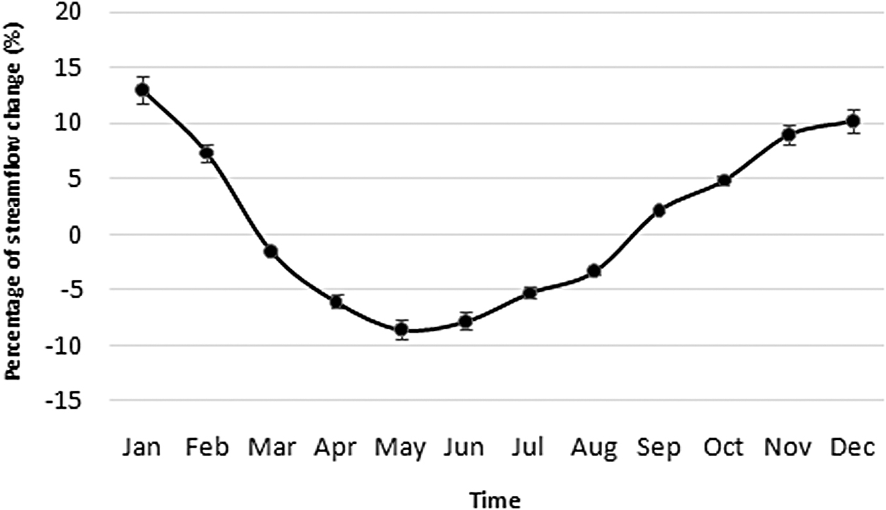
The final scenario S3 (Expansion of Forest land), the result is represented in Fig. 9, shows the peak stream flow at the Bao Yen station decreased by 4.60% and the stream flow during dry months significantly increased by 11.43%. In addition to the calculated results, the average monthly volume in flood season decreased by 5.43% (especially in May with 8.51%) and increased by 4.83% (especially in December with 10.21%) in dry ones. The stream flow tends to change quite drastically from November to January. As expected, the greater forest cover leads to relatively more evapotranspiration than from unused lands and hence lowers overall flows as well as a decrease in peak flows and an increase in base flows due to the greater infiltration rates.
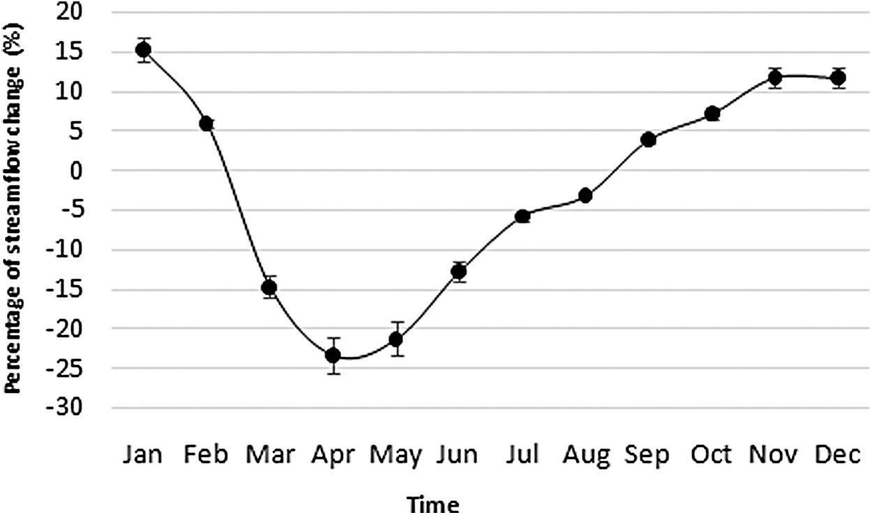
Mean monthly discharge changes under Scenario 3 (Expansion of forest lands).
Conclusions
The research conducted here represents a first and a necessary step in applying the SWAT model to the Thac Ba reservoir basin; namely the calibration and validation of the water quantity component on the major inflowing river to the Thac Ba reservoir. The SWAT model performed well in simulating the trend of surface flows. It also showed the potential to quantify the effects of land use changes on the stream flows with monthly time intervals. All three scenarios reflected the change of stream flows that might occur from changes in land use. In general, the result showed an excellent agreement between the observed and simulated daily stream flows for the calibration period (NSE = 0.895; R2 = 0.906) and for the validation period (NSE = 0.869; R2 = 0.871). The simulation of some peaks was underestimated, but overall, the agreement between the observed and simulated stream flows was considered to be much better than expected. The statistical and graphical evaluations of the model performance showed that it could be used for assessing impacts of land use change on stream flow. Based on the scenario results, the local government and stakeholders should pay special attention to the urban expansion and reforestation for controlling stream flows. Further research will focus on calibrating the model for sediment and nutrient concentrations at Bao Yen as well as considering the effect of land use changes and climate change on the water quality and quantity.
Footnotes
Author Disclosure Statement
All authors have no conflict of interest to report.
Funding Information
The author(s) received no specific funding for this work.