
Abstract
Abstract
India has been pirating 60% of the Bangladesh Gangetic ecosystem's water since 1975 after construction of a feeder canal by the Farakka Barrage in the name of maintaining the navigability of the Calcutta Port located at the mouth of the Hooghly River. As a consequence, massive ecocide has unfolded in Bangladesh. India's forced piracy and Bangladesh's compelled consent to piracy, for a meager discharge, have continued for the past forty years. This study focuses on Calcutta Port's navigability source, navigability loss and past maintenance, India's water crisis, and India's use of the looted water resources. Sources of information included electronic and print media, site visitations, expert interviews, fieldwork, travel accounts, research institutions, and government offices. The study finds Calcutta Port's brisk use during the British period, Calcutta Port's Ganges discharge-independent establishment, India's development of other ports in post-independent India, the storage of the Hooghly's water in reservoirs, Calcutta Port's navigability loss unworthy of causing ecocide in Bangladesh, India's inland cruise line setup with the pirated water, and the stealing of water from border rivers. As a member of the Ramsar Convention inter-governmental panel since 1971, India's actions violate the Convention's doctrines of saving a permanent or temporary water body without regard to its location, kind, size, and depth through international convention. For environmental justice, India should pay Bangladesh earnings from the looted water's commercial use, cover dredging costs of Bangladesh's clogged rivers and canals, close the feeder canal, demolish the Farakka Barrage, and return the water to Bangladesh. Furthermore, India should be financially responsible for the full recharge of the groundwater, purification of arsenic, treatment for millions of potential and current arsenic patients and 20% arsenic fatalities, lost livelihoods, salinity removal, rebuilding of the eroded coast, revitalization of extinct flora and fauna, and establishment of normal climate.
Introduction
Natural and world trends
Each ecosystem worldwide contains thousands of species of native flora and fauna that are shaped by the land, air, and water conditions specific to the individual region. Rivers that originate on higher lands flow over the land to meet the ocean, sustaining the flora and fauna throughout its course. A river discharge that crosses the international boundary belongs to the downstream ecosystem. A nation's gross domestic product (GDP) is related to these basic resources, although their presence is not incorporated in the GDP calculation because of their invariable presence. Preserving natural laws and environmental processes should not require legalization. Instead, the natural ecological balance established over thousands of years in a region should be considered the most stable and beneficial for the land.
Almost 75% of the world's land mass falls under international river basins. This includes 44 countries that have at least 80% of their land in international river basins. Because of recognition of downstream water rights and for mutual benefits, many countries have signed treaties to share water from a common discharge source, including Mexico and the U.S. (the Rio Grande and Colorado Rivers); France and Spain; Macedonia and Greece (the Vardar/Axois River); Turkey, Syria, and Iraq (the Tigris and the Euphrates Rivers treaty); Syria and Lebanon (the Orontes River); Egypt and Sudan (the Nile River treaty); and Gini, Malee, Mouratania, and Senegal (the Senegal River treaty). Except for China and Burma, all riparian nations have been working together in the Mekong River Commission.1 In all of these treaties, each country upholds their agreements to mutually preserve natural resources, and historically, no upstream riparian country has taken advantage of their position to withhold and affect the water for the downstream riparian country's ecosystem.
Upstream water diversion and water piracy
Due to the current issues, a differentiation between “upstream water diversion” and “water piracy” needs to be established to clarify the actions of the upstream country. Natural resources including air, land, and water should not be displaced from one country to another. Recent reports have indicated that disproportional amounts of water have been withdrawn from an upstream country, greatly impacting the resources available in the downstream country. Thus, it has been critical to introduce the term “piracy.” In simple words, an upstream country commits water piracy when her water use causes any degree of damage to the downstream ecosystem. Water pirates not only affect individual components of the ecosystem, but they can completely destroy an ecosystem. Whereas pirates in the Indian Ocean, publicized by the media, number no more than a handful and rob for the sake of their individual livelihood, water pirates sit at the helm of a nation and establish national policy for water piracy to impact an entire downstream ecosystem. Water piracy occurs when a nation's own water resources are locked in reservoirs to create a fake water shortage, and water withdrawals are then made either from an unconnected river system or from the same river system to make up for the shortage. This forces the downstream ecosystem to die or suffer under the hardship of reduced supply. The downstream country is then forced to face the consequences of limited resources, and somehow manage the meager discharge for best survival possibilities. The upstream country currently remains immune from the violations or non-violations of the terms and conditions in the agreements with the downstream country. Furthermore, piracy will be defined as when the upstream country withdraws water without consideration for the requirements of the downstream country. Water withdrawals or water diversion may not be pursued when the upstream country recognizes the same water rights for the downstream country as for the upstream country, does not distinguish between the needs of the two, and acts sincerely to uphold this aim. Thus, the introduction of the term “water piracy” is required to place global attention on the inhuman actions of ecosystem destruction.
The dam-rich upstream Ganges
Barrages on the Ganges include the Ganga Canal at Hardwar, the Ganga Barrage at Kanpur, and the Farakka Barrage at Farakka, West Bengal. On the Bhagirathi, the uppermost part of the Ganges in northern India, there are approximately 17 operational, under-construction, and planned dams and barrages (Figure 1).2 These include Karmoli, Gangotri, JothGanga, Bhairanghati-1, Bhairanghati-2, Harseel, Loharinag Pala, Pala Maneri, Maneri, Joshiara, Bhilangana-1, Bhilanganga-2, Teheri, Koteshwar, Kotlibell-1A, Kotlibell-1B, and Kotlibell-2. The Yamuna, the largest tributary of the Ganges, has at least six dams/reservoirs and canals. The sub-tributaries of the Ganges have at least 15 dams and reservoirs, and the sub-sub-tributaries of the Ganges have at least three dams and reservoirs. Figure 2 shows the dams on the Alakanda River,3 a tributary of the Ganges, coming from the right side in Figure 1 to meet the Ganges. All these constructions, except the Farakka Barrage, withdraw water from the Ganges and its tributaries' basins. Farakka Barrage is used for pirating water for the unconnected Hooghly River, the water of which is locked in reservoirs upstream of its tributaries and sub-tributaries.
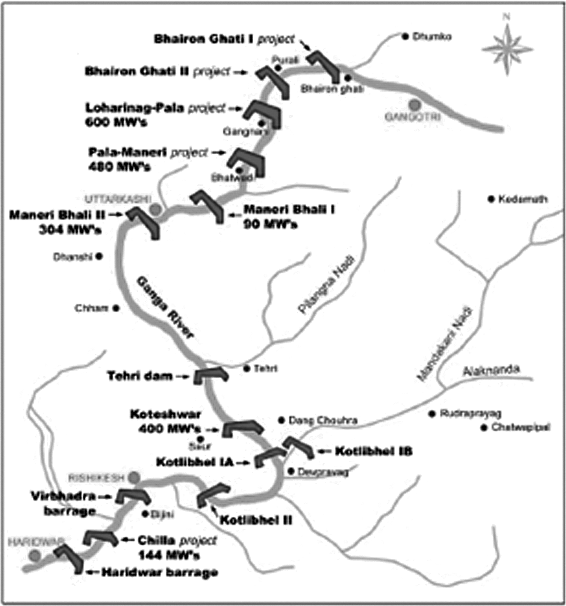
Operational, underconstruction, and proposed barrages on the Ganges. Source: Courtesy of <
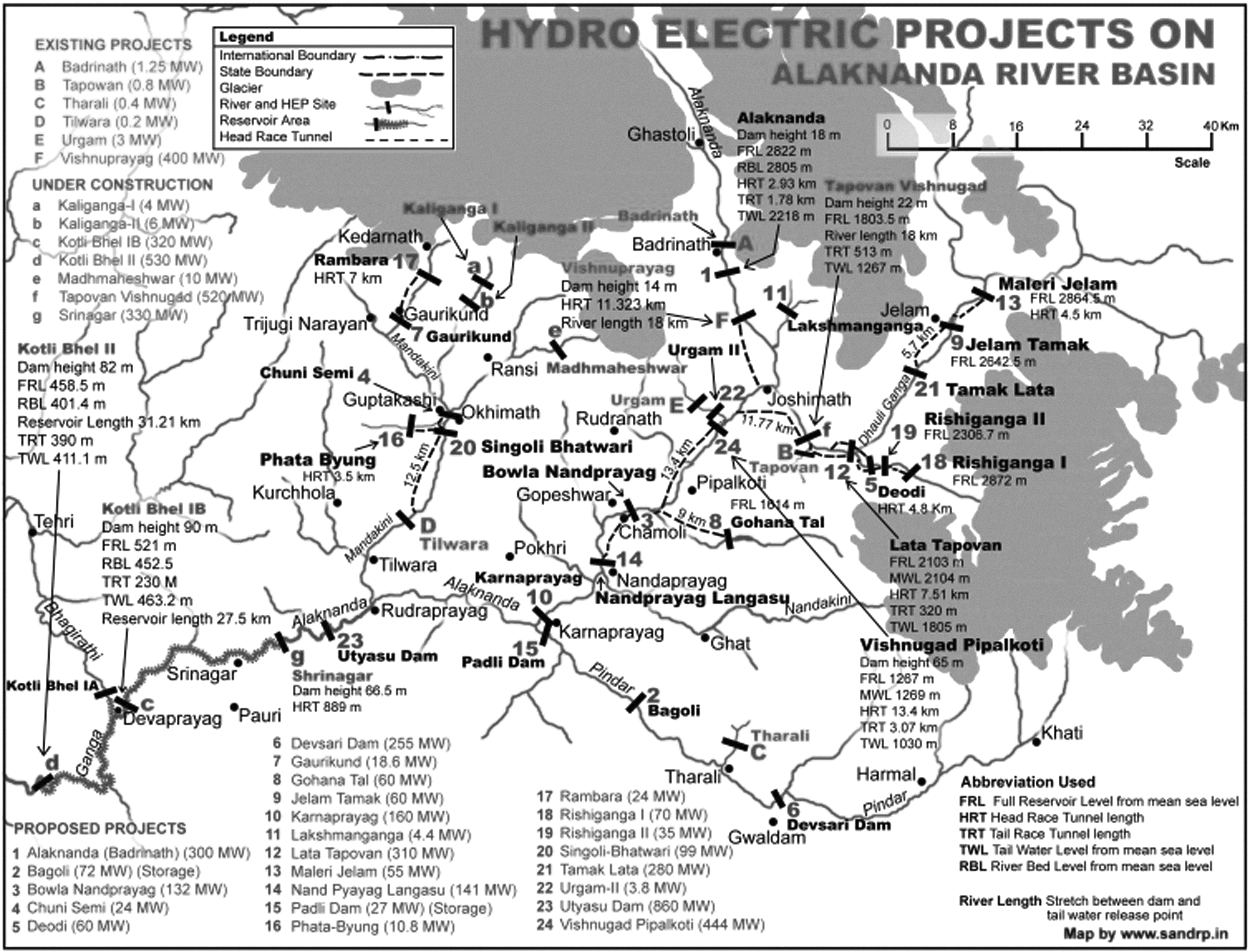
The dam-locked Alakanda River, a tributary of the Ganges. Source: <
The Hooghly River and Farakka Barrage on the Ganges, and water piracy
The Hooghly River is a very tributary-rich, 260 km long river. The Calcutta Port is located 203 km downstream, at the mouth of the river. Even a few hundred years before the founding of the Calcutta Port in 1869, the Hooghly water course was separated by a seasonal canal from the Ganges that was completely unfit to be a part of a navigable route, not to mention for a port. If the Ganges was supplying water for the Calcutta Port's navigability, the downstream ecosystem in Bangladesh and her hydrogeochemical characteristics would improve accordingly on water scarcity and would not be sustainable on water abundance. Thus, the Calcutta Port's viability never depended on the expected Ganges discharge into the Hooghly. Figure 34,5,6 shows the tributaries and some of the sub-tributaries of the Hooghly, including the Ajoy, the Barakar, the Damodar, the Dwarakeshar, the Shilabati, the Kangsabati, the Mundeshwari, the Rupnarayan, the Kaliaghat, and the Haldi, all of which are forcefully discharged to the Hooghly River. The Hooghly's tidal water surge reaches more than 2.3 meters in height. Unfortunately, experts in India have grossly distorted the facts on the Hooghly, propagandizing the Ganges as the sole source of water for the Hooghly.7

The dam-locked tributaries of the Hooghly at its downstream. The right side top figure shows the Farakka Barrage across the Ganges and the 25-km long perennial feeder canal on the left bank for water piracy. On the right side, the bottom figure shows the pirated water-fed Hooghly. Sources: Courtesy of <
In 1975, India built the Farakka Barrage on the Ganges approximately 16 km from the Indo-Bangladesh border. The distance between the Farakka point and the Haldia Ghat (where the river Haldia enters the Hooghly in the left side of the inset of Figure 3) located downstream at the mouth of the Hooghly is 560 km. After construction of the Farakka Barrage, India dug a 25-km long feeder canal to connect the Ganges with the Hooghly River to pirate approximately 60% of the Ganges's downstream discharge to the unconnected Hooghly basin. Indian water piracy has turned what used to be a seasonal canal into a perennial navigable source of water discharging more water than the 5-km wide Ganges itself discharges through Bangladesh. This discharge that was originally due for the downstream Ganges in Bangladesh was instead used by India for commercial needs.
For comparison, the nearly 300-km long Ganges in Bangladesh has only one tributary, the Mahananda, which faces two dams at the upstream boundary to India. Dozens of primary, secondary, and tertiary tributaries that branch up the coast make the Ganges basin a riverine one.
Project country
The project country Bangladesh is located in the Ganges-Brahmaputra-Meghna basin in the latitude range of 20°34' to 26°38' and the longitude range of 88°01' to 92°41'E (Figure 4).8 Bangladesh water bodies include more than 1,000 rivers, including 58 international rivers; natural lakes; reservoirs; about 400 haors; 54,488 hectares of oxbow lakes; 1,000 beels; 147,000 hectares of ponds and tanks, estuaries, and seasonally water covered floodplains; and 577,100 hectares of mangrove forests.9,10,11 This wetland ecosystem in Bangladesh survived on approximately1,200 billion cubic meters of river discharges, mainly from the three principal rivers (the Ganges, the Brahmaputra, and the Meghna) (Figure 5),12 343 billion cubic meters of rainfall, and 23 billion cubic meters of groundwater (Figure 6).13 Of the approximate 142,780 square kilometers in Bangladesh, roughly 86% of the land, i.e., 123,300 square kilometers, is in an international river basin. The Ganges basin ecosystem has nourished approximately one-third of the Bangladesh ecosystem.
The Ganges-Brahmaputra-Meghna basin. Bangladesh is the outlet of the river system. Source: Courtesy of B. M. Abbas, A. T. 1996.
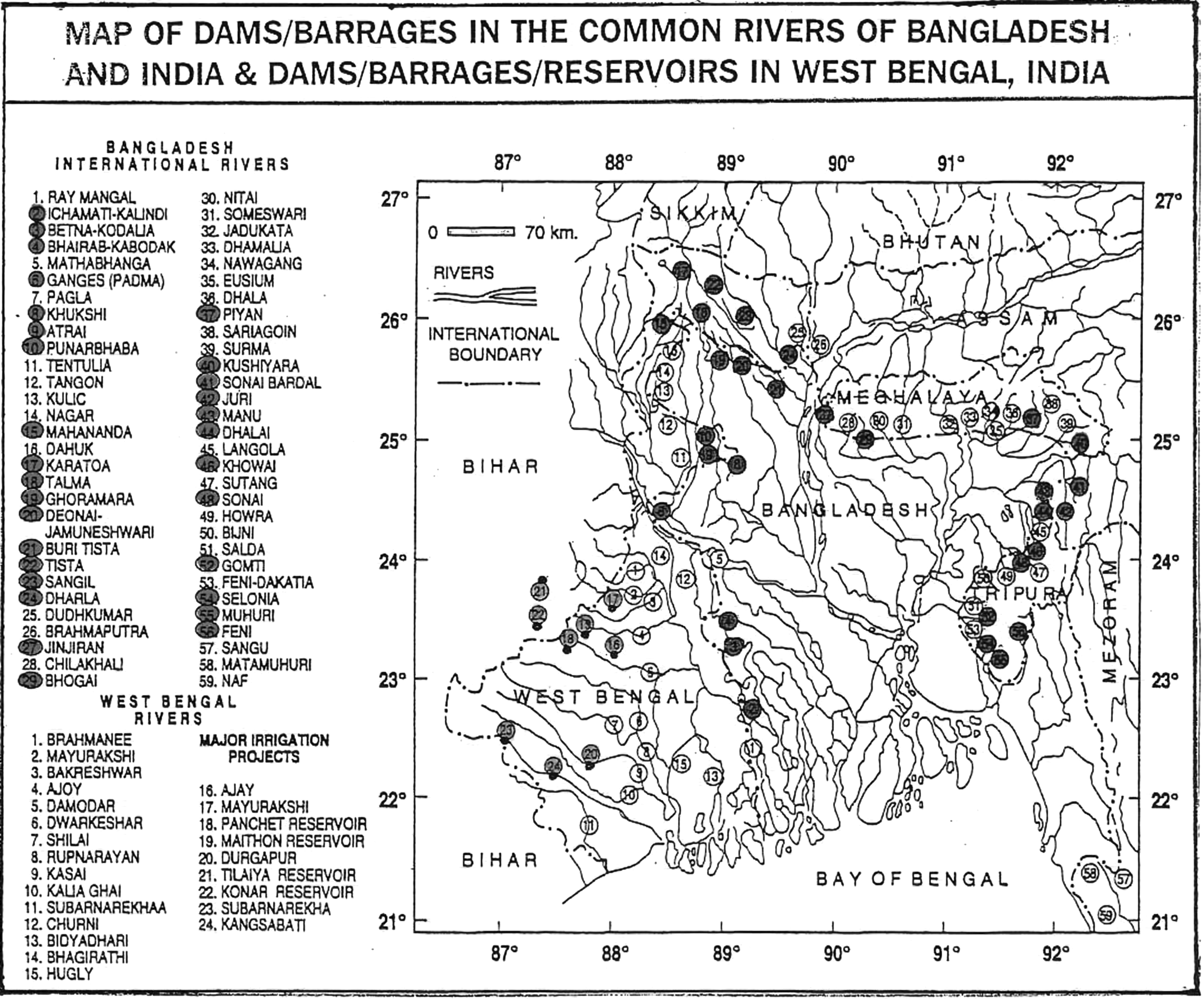
The famous ring of dams around Bangladesh border. There are fifty-eight international rivers which are common to both India and Bangladesh. India's water piracy takes place in, at least, 50% of them. Source: Adel, M. M. 2001. Effect on water resources from upstream water diversion in the Ganges basin, Journal of Environmental Quality, 30:356–368.
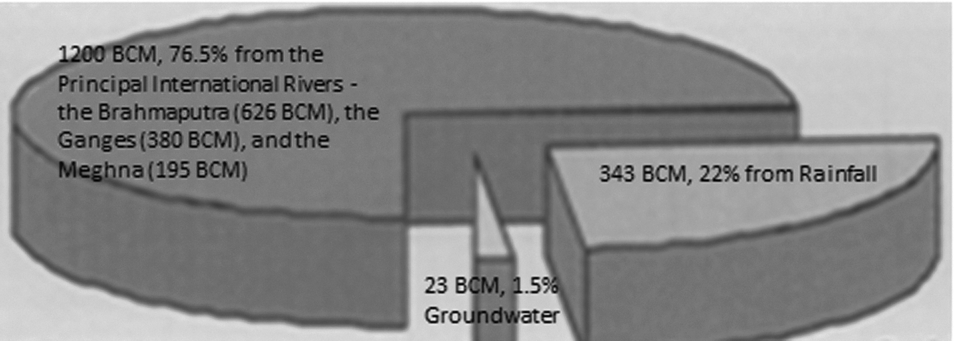
Natural water resources for Bangladesh, rivers being the prime source. Source: Courtesy of Hossain et al., 2001.
For years, the major roles of the Ganges basin wetland ecosystems included groundwater recharge, groundwater discharge, groundwater quality maintenance, floodwater storage, storm surge, irrigation, a filtering system for polluted/stagnant water, shoreline stabilization and erosion reduction, obstruction to salinity intrusion, sediment trapping, soil fertilization, nutrient deposition, food chain maintenance, crop production, livestock raising, seasonal and annual livelihood provisions, fisheries production, essential minerals and other nutrients provision, wildlife habitat provision, sports and recreation facilitation, religious ritual observations, natural heritage values maintenance, aesthetic beautification, biomass production, wood/fuel provision, goods transportation, inland river port developments, bio-diversity presentation, and micro-climate stabilization.14,15,16,17,18,19,10,20,21,22,23,24,25,26,27
Ecocide in Bangladesh
As in any wetland ecosystem, the Gangetic ecosystem's abiotic elements, such as sunlight, water, air, and soil, and the biotic elements, such as people, aquatics, amphibians, animals, birds, plants, trees, and microorganisms, are bound by complex interrelationships. An ecosystem cannot survive with only 40% of its founding and sustaining water requirements. As a consequence of the water piracy, many elements of the biotic system have become extinct over vast expanses of areas. The ecocide effects in the Ganges basin include the loss of the surface water resources, destruction of the inland navigable routes, depletion of the natural breeding and raising grounds of 109 species of Gangetic fishes and natural wells for groundwater recharge, alarming sinking of the groundwater table, contamination of the groundwater table with arsenic in the continued absence of the recharging surface water, and the overdependence on the groundwater. The impact on human society and quality of life is severe, with the risk of arsenicosis causing a 20% fatality rate, the break-off of family ties of arsenic patients, rising malnutrition from the scarcity of fish (the cheapest source of calcium and animal protein), and the loss of annual and seasonal livelihoods. Impacts on the climate and land have been observed, including the generation of extreme climate with an increased number of warmer summer days and colder winter days than prior to1975, scanty and erratic rainfalls, the immeasurable loss of biodiversity, coastal erosion, the widespread inland advancement of a saline water front, and the deterioration of the Ganges water quality.28,29,30,31,32,33,34,35,36,37
India's policy and consequences in Bangladesh
India broke the initial 41-day test-run agreement of the Farakka Barrage in April/May 1975, and continued water piracy until the end of 1977, when a five-year treaty was signed after the issue was raised to the United Nations (UN) General Assembly. This treaty could also be considered a forced consent to piracy rights in exchange for very inadequate discharge. Later, two memorandums of understanding were signed by the two governments in 1982 and 1985 to grant India the piracy rights. India's unilateral piracy continued from 1988 through 1996, toward the end of which a 30-year forced consent was given by Bangladesh.38 The shortfall of discharge through Bangladesh up to 1996 is shown in Figure 7. This discouraging trend still continues today. Notably, according to the piracy right given to India, the leftover discharge through Bangladesh on March 27, 1997 was to be 976.93 cu m/s, but the discharge through Bangladesh was only 184.06 cu m/s. This demonstrates that nearly six times more water is pirated by India than the right affords.39
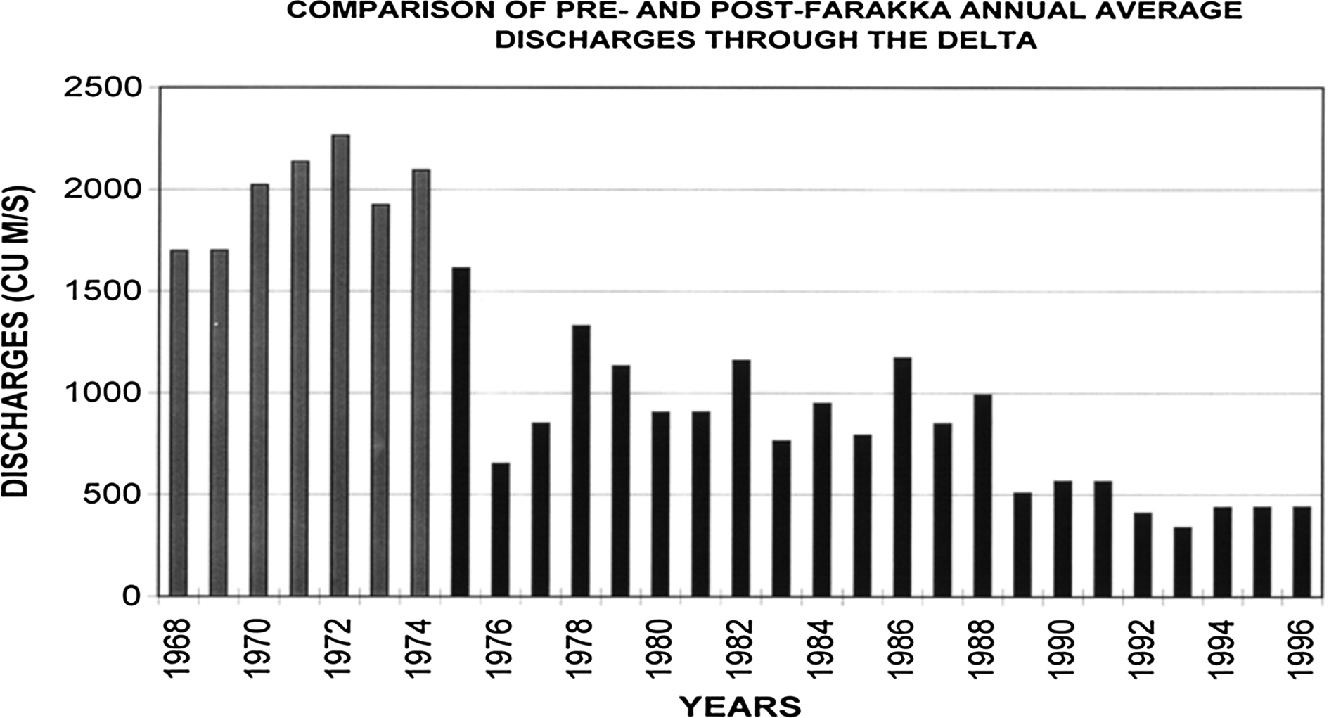
The dark bars represents the water available for Bangladesh ecosystems after India has pirated water out of what is represented by the grey bars. Source: Hebblethwaite, G. 1997. The impact and implications of the Farakka Barrage upon Bangladesh. B. Sc. Thesis. Newcastle University, UK.
India's commitment to Ramsar Convention and Indian policy action
India is a signatory of the world's only inter-governmental advocacy group for wetland preservation, the Ramsar Convention.40 Yet, the actions of India in the water piracy issue indicate a case in which a water body is very clearly not being saved, despite its critical size. Despite the commitment by India to this world organization, Bangladesh's inland and coastal ecosystems were still deprived of approximately 60% of Ganges water, as illustrated in Figure 741 in the name of maintaining the navigability of Calcutta Port. The condition of the Ganges is shown in Figure 8.42,43
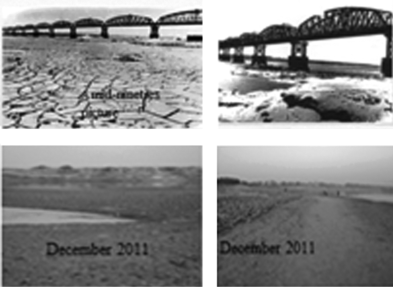
The top two pictures describes the condition of the Ganges in about the mid-nineties by the Hardinge Bridge. Source: Courtesy of Salahuddin. The bottom two show the condition by the largest riparian city Rajshahi in Bangladesh. Source: Courtesy of Jebouni and Sadequl.
Focus of this article
All riparian countries have due share in their common river water. Until now, there have not been any instances of locking water resources in reservoirs to create a fake water shortage in an isolated river system for pirating the downstream ecosystem's water from another river system to make up for the fake shortage in the unconnected river discharge. The water piracy strategy employed by India has been the sole exception in the global trend of mutual agreements to uphold water treaties and acknowledging both countries' water rights. This article focuses on the water piracy strategy of India and the fringe effects that have caused numerous irreparable and irreversible consequences in Bangladesh.
Materials and Methods
This article is based on a review of relevant materials, dating back to the independence of India from the British rule in the middle of the last century, and the observations and study of the evolving current situations in the Bangladesh Ganges basin. India's argument for the current water strategy was centered on the navigability loss of the Hooghly River and the Calcutta Port, which necessitated examining data of all construction in the basins of the tributaries and sub-tributaries of the Hooghly, as well as the founding and establishment of Calcutta Port in undivided India and its subsequent fall in post-independent India. Careful searches were performed as to how the forceful discharges to the Hooghly were lost that could have destroyed its navigability. Whether India developed other ports after independence was also examined. Thorough research was conducted to determine the ultimate aim for use of the pirated water. In addition, information was collected on India's Farakka Barrage construction, the violation of Bangladesh's consent to the test-run, and the discussions with Bangladesh, in which consent was forced to give piracy right of Bangladesh's interior ecosystem's water. Furthermore, the visual information on the clogging of Bangladesh's rivers and canals and the drying of the surface water resources was collected. Whether India's hegemonic policy went against any inter-governmental organization's policy of saving water resources was noted. Information on the Indo-Bangladesh relation from the birth of Bangladesh up to the current situation was reviewed. Finally, to better evaluate India's water piracy policy, India's relationship with neighboring Pakistan was also investigated. Sources of data include site visitation, field work, interviews, travel accounts, books, thesis, newspaper articles, maps, government offices, research institutions, and Internet resources.
Results
Simultaneous plan for Hooghly water storage and Ganges water piracy
India took simultaneous steps for plans for the Farakka Barrage on the Ganges and the dams and reservoirs on the tributaries and sub-tributaries of the Hooghly River. India became independent from the British rule in August 1947, and shortly thereafter, the national focus was on the development of water resources. The Damodar Valley Corporation (DVC)44 was established on July 7, 1948 by an Act of the Constituent Assembly of India.45 The DVC plan was developed by W. L. Voorduin, the same U.S. senior engineer from the Tennessee Valley Corporation (TVC),46 and the plan was developed to replicate the TVC plan. Contrary to Voorduin's self-sufficient plan of eight dams and barrages designed for flood control, irrigation, power generation, and navigation, all inclusive, India revised the plan by dropping some of the elements and proceeding with only four dams: the Tilaiya, Konar, Maithon and Panchet, and Durgapur Barrage.47 It was the tributaries of the Hooghly (the Ajay, the Damodar, the Mundeshwari, and the Rupnarayan) at its downstream that maintained the Calcutta Port's navigability. Damming those tributaries reduced the Hooghly's flow and caused siltation.3,48 The four dams built under DVC—the Tilaiya Dam on the Barakar River (1953), the Konar Dam (1955), the Maithun Dam on the Barakar (1957), and the Panchet Dam on the Damodar—can control 18,400 cu m to 7,100 cu m of floodwater.
Projects on the Hooghly's tributaries and sub-tributaries
The 288-km long Ajoy is a tributary of the Hooghly. The basin of the Ajoy is 6,000 sq km in area, and the Ajoy has four tributaries: the Parth and the Joyanti in Jharkhand, and the Tumuni and the Kunur in West Bengal. The Sitkia Dam is on the Ajoy in Jharkhand.49 The Hinglo is another tributary of the Ajoy, with a basin area that extends over 2009 ha. The capacity of the Hinglo dam is 17,102,000 cu m.50
The tributary Runnarayan originates from the Choto Nagpur Plateau, where it is called the Dhaleshwari. Near Bankura, it is named the Dwarkeshar, and where it meets the Shilai River near the town of Ghatal, it is called the Rupnarayan. Eventually it enters the Hooghly. The Rupnarayan supports a thermal power plant at Kalaghat.51
The 592-km long Damodar River separates the Dhanbad District of the Jhankhand province and the Purulia district of West Bengal. The Barakar and the Damodar meet at Dishargarh. The Panchayet Dam was constructed near their meeting place, upstream on the Damodar. Its capacity is 170,370,000 cu m, and the reservoir has an area of 27.92 million sq m. The Tilaya Dam is on the Barakar in the Kodema District in Jharkhand Province, and its catchment is 984 million sq m. Its highest height is 30.2 m and its length is 366 m. The dam is 9 km from Cheerkunda on the Grand Trunk Road.52
The tributaries and sub-tributaries of the Damodar include the Barakar, the Konar, the Bokaro, the Haharo, the Jamunia, the Ghari, the Guaiya, the Khadia, and the Bhera. In its lower course, almost all of its discharges fall in the Mundeshwari, which is linked to other rivers. Finally, all its discharge falls in the Rupnarayan. Its remaining discharge goes under the name Damodar to fall in the Hooghly south of Calcutta.
The Durgapur Barrage across the Damodar is controlled by the Government of West Bengal and was constructed in 1955, downstream of all dams. It is 692 m long and 12 m high, and has 34 gates, including the under sluices. The gate size measures 18.3 m×4.9 m and the left and right under sluices 18.3 m×5.5 m.53
The Tenughat Dam across the Damodar River was constructed in 1974 at Tenughat by the Government of Jharkhand. It is an earthfill dam with composite masonry cum concrete spillway. Its height is 55 m and length is 5 km, and its live storage capacity is 224 million cu m. It supplies water to the Bokaro steel plant and Bokaro industrial area.54
The Konar Dam is on the Konar River, a tributary of the Damodar. It is located in the southern part of the Hazaribag District in Jharkhand. The Konar Dam is 4,535 m long and 48.77 m high. The Konar Reservoir area is 27.92 million sq m, and its catchment is 997 million sq m.55
The Bokaro Dam is at the confluence of the Konar and the Bokaro Rivers. This dam supports the Bokaro thermal power plant.56
The Barakar River in the principal tributary of the Damodar River is shown in Figure 2. The area of its catchment is 6,159 million sq m. Its main tributaries are the Barsoti and the Usri. Fifteen small and medium size streams also fall into it.57
The Maithon Dam on the Barakar River is one of the most successful works of the DVC as claimed by India. The dam was completed in the first five-year plan of India.58
The Kangsbati River originates the Choto Nagpur Plateau in Jharkhand Province. Near Keshpur, it bifurcates into the north-flowing Palarpai that flows into the Rupnarayan and a southeast-flowing branch that meets the Kaliaghai River and flows under the name of Haldai and falls into the Hooghly near Haldai. The Kangsbati Project includes both the Kangsbati Irrigation Project and the Kangsbati Reservoir. The irrigation project uses water from the Kangsbati, the Shilabati (Figure 3), and the Bhairab Rivers. It irrigates 3,484.77 million sq m. There is a dam built at Khattay that measures 38 m high and 10,098 m long. A dam was built on the Kangsbati near Medinipur in 1972 that has been brought under the Kangsbati Project.59
The Mayurakshi is one of the main rivers of West Bengal. The Masanjore Dam, also known as the Canada Dam, is approximately 65 km upstream of Seury in West Bengal. The dam is 47 m high and 660 m long, and its reservoir area is 67.4 million sq m (16,650 acres). Its full capacity is 620 million cu m. The Tilpara Dam is located 32 km downstream from the Masanjore Dam. The 309 m long, 34.44 m high dam has 21 lock gates to control the flow of the Mayurakshi. The water that would flow freely to the Hooghly has been locked by the dams.60
The Bakreshwar is a tributary of the Mayurakshi. It originates from Santhal Pargana District of Jharkhand Province, and passes through the Birbhum District to meet the Kopai River. The combined stream falls into the Mayurakshi River in Murshidabad District. The Bakreshwar Canal is used in irrigation. The Bakreshwar Reservoir is named Neel Nirjan. The Bakreshwar Thermal Power Plant is located near Chinpai. None of the tributaries or the sub-tributaries of the Hooghly can flow uninterrupted.61
The Gandheshwari River is a tributary of the Dwarkeshar. It flows through the Bankura District of West Bengal. It meets the Dwarkeshar River near Bhutsahar after flowing to the southwest of the Susunia Hill and north of Bankura.62
The Haldi River is the southernmost tributary of the Hooghly. It flows through Medinipur District. It is the joint flow of the Kalighai River and the Kansai River. It is 24 km long.63
The move of the Indian government for Farakka Barrage
The Farakka Barrage construction news was launched in October 1951, stating that India would divert the Ganges water to the Hooghly to keep it navigable. At this time, Bangladesh was part of Pakistan as a province called East Pakistan. The Pakistan government launched a protest on October 29, 1951, and India responded on March 8, 1952, that the project was in the planning phase and that Pakistan would be informed before materialization of the plan.
In the meantime, India developed another plan to divert water from the Gandak River, a tributary of the Ganges, to the states of Bihar and Uttar Pradesh. On May 8, 1952, Pakistan reported to India the losses that East Pakistan would face in the event of the Farakka Barrage and the water diversion from the Gandak. India responded after one year, stating that the Gandak Project was being studied. On September 14, 1954, Pakistan informed India of the Ganges-Kabodak Project downstream of the Ganges in East Pakistan for increased agricultural productions.
Correspondences between the two countries continued for nine years. India did not share any information to Pakistan on projects other than the Farakka Project on the Ganges. Later, 11 meetings were held between India and Pakistan; the first five were on the expertise level, the second five were on the secretaries level, and the last one was between two ministers of the countries, in which it was decided that India would not start the operation of the barrage until the sharing of the water would be settled. The construction of the Farakka Barrage was completed and the only work that remained was the digging of the feeder canal. In 1971, after nine months of savage fighting, East Pakistan was separated from Pakistan and emerged as an independent nation with Indian assistance.
In April 1975, the first agreement between the governments of India and Bangladesh was a 41-day test-run, which India violated and instead pirated water until the end of 1977. After raising the issue to the UN General Assembly, a five-year forced consent was given by Bangladesh in exchange for a meager discharge in the Ganges to save as much of the ecosystem as possible. The approach with the UN prompted anger by some of the Indian media towards Bangladesh. Later on two occasions, in 1982 and 1985, India obtained forced consent to piracy from Bangladesh. Water piracy continued from 1988 through 1996, at which point, and in response to repeated insistence for Bangladesh's ecosystem's survival, a 30-year piracy right was obtained by India after approximately 100 meetings between the nations.38
According to the current agreement, Bangladesh and India share equally if the Farakka point flow in the Ganges is 1,982.18 cu m (70,000 cusecs) or less. If the Farakka point flow is 1,982.18 to 2,123.76 cu m (70,000 to 75,000 cusecs), Bangladesh receives 991.09 cu m (35,000 cusecs), and the rest is for India. If the Farakka point water measures more than 2,123.76 cu m (75,000 cusecs), India receives 1,132.67 cu m (40,000 cusecs) and the rest is for Bangladesh. From these three discharge-based divisions, and based on the set up of the upstream dams and barrages shown in Figures 1 and 2, the Farakka point will continue to receive less and less than than 1,982.18 cu m. India never follows her measured amount. She always pirates the larger part.64 In instances that the dam that passes water to Bangladesh shows breaks or cracks, the West Bengal Prime government protests that Bangladesh is receiving more water.65 In Bangladesh, the lesser amount of water share is covered up by the fact that the groundwater recharges the Ganges water where the discharge monitoring station is located. As a result, the actual smaller amount that India releases through the Farakka Barrage to Bangladesh is very difficult to ascertain.66 The dominance of India over Bangladesh regarding water release through Bangladesh will be presented in a different article.
India's focus on other ports and ingenuous demonstration for the Farakka Barrage
After the partition of India, India spent less for the Calcutta Port than any other port. During the British colonial rule (1870–1946), the entire Bengal was the hinterland of the Calcutta Port. All raw materials from India were exported to the UK through the Calcutta Port. The greater part of Bengal became East Pakistan in 1947. The port carried 40–50% of India's imports and exports. In the 1960s, the port use dropped to 23%. It further dropped to 11% in the late 1970s. In the 1980s, the use declined to only 10%.67 Figure 9 shows the trends in ships in Calcutta Port.41,66 The dark bar represents domestic traffic, and the white bar indicates foreign traffic.
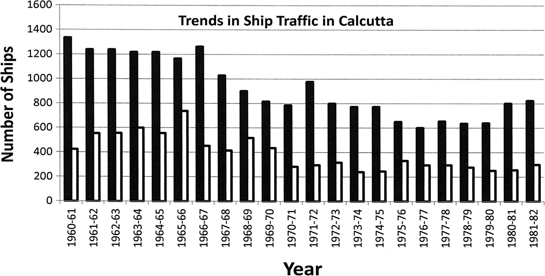
Trends in ships arrival in Calcutta Port, a result of losing the major part of the port's hinterland. Source: Hebblethwaite, G. 1997. The impact and implications of the Farakka Barrage upon Bangladesh. B. Sc. Thesis. Newcastle University, UK.
For post-Farakka days, Patel writes that the dredging of the Calcutta Port was probably the only effective solution because the volume of traffic did not increase significantly.68 He further wrote that the importance of the Farakka Barrage was not demonstrated in a convincing manner.
Crow referred to a study conducted by Sau on the decline of the traffic in Calcutta port.69 It is said that there were no physical or organization constraints against the increase of the traffic in Calcutta Port. He points to the decline of the industrial activity and overall economic activity as the more likely causes than the siltation of the Hooghly for the shortfall of traffic at Calcutta Port.
Calcutta Port's navigability not an immediate problem
The navigability loss of the Calcutta Port, 126 km above the sea, was not such a critical issue that necessitated the deprivation of the Bangladesh Ganges ecosystem's water. Three and one-half decades later than the construction of the Farakka Barrage, India estimated the dredging and maintenance cost of the Calcutta Port.70 However, the declaration of the Ganga-Bhagirathi-Hooghly river system from Allahabad to Haldia as the National Waterway No.1 was made just a decade after the construction of Farakka (vide National Waterway, Allahabad-Haldia stretch of the Ganga Bhagirathi-Hooghly River, Act 1982 (49 of 1982)).
India's plan for commercial use of the pirated water
The National Waterway No.1 started operating from October 27, 1986 after the formation of the Inland Waterways Authority of India (IWAI). It stretches from Haldia to Allahabad for a distance of 1620 km as shown in Figure 10.71 The minimum depths available are 3 m for Haldia-Farakka, 2.5 m for Farakka-Patna, 2 m for Patna-Varanasi, and 1.5 m for Varanasi-Allahabad. The expanses of the newly developed navigable routes are Haldia (Sagar)-Farakka 560 km, Farakka-Patna 460 km, and Patna-Allahabad 600 km, making a total of 1,620 km. The water piracy that was demanded by India for the purpose of improving Calcutta Port navigability, did not seem to work because of the additional port dredging plan during the piracy period. This suggests that the setup of the nation's No.1 waterways was the primary aim for water piracy.

Ganga-Bhagirathi-Hooghly river system from Allahabad to the Haldia Ghat was declared as National Waterway No.1. This was the prime aim of the water piracy from Bangladesh ecosystem. Source:
Water stealing
The setup of barrages, dams and reservoirs around the Bangladesh border by India is shown in Figure 5. Not only is more water stolen from the Ganges than stated in the forced consent, water is stolen from rivers that run in the international border between the two countries. Figure 11 illustrates one such occasion. Measurements of this water stealing have not been conducted.72
One instance of India's water stealing using pipes through the jungle and underground from the Bangladesh's border area Feni River (the left side inset). A canel carrying water to distant farm lands lack adequate water for irrigation (middle and the right side inset). Source: Courtesy of ntv, an international television broadcasting channel in Bangladesh, 2011.
Discussion
Revision of TVC plan for the envisioned water piracy plan
The development of the original plan was guided by W. L. Voorduin, a senior engineer from the TVC in the U.S., and outlined in eight dams and barrages designed for flood control, irrigation, power generation, and navigation. The plan resulted in trapping the water resources in the sub-tributaries and tributaries instead of letting it discharge in the Hooghly. It would be surprising if navigability was not considered in the plan for the water development, an act that makes TVC famous in the U.S. If navigability was not considered, the incomplete plan would result in the siltation of the Hooghly.
Contrary to Voorduin's original plan of eight dams and barrages that would save the navigability, India proceeded with only four dams: the Tilaiya, Konar, Maithon and Panchet, and Durgapur Barrage,73 which can control 18,400 cu m to 7,100 cu m flood water. Establishing only four dams had critical consequences in the Hooghly, and it appears that the aim was to pirate downstream Ganges ecosystem's water once the DVC-planned dams and reservoirs were in place on the tributaries and sub-tributaries of the Hooghly River, interrupting their discharges in the Hooghly. It was the tributaries of the Hooghly (the Ajay, the Damodar, the Mundeshwari, and the Rupnarayan) at its downstream that maintained Calcutta Port's navigability. Damming those tributaries reduced the Hooghly's flow, which could have caused the siltation.48
Calcutta Port's navigability loss, a self-created problem
Independent India lost a completely undivided Bengal, which the British colonial power used as the hinterland. Instead, India received an area of Bengal that measures barely 60% of independent Bangladesh. Any industrial development the colonial power made in and around Calcutta would falter from losing the greater raw material production area of Bengal. In post-independence days, activities in the port could not be maintained at the levels of the British. This is one possible reason that India neglected the development of the Calcutta Port in the post-colonial period.
No urgency in port's navigability remediation
The Indian Foreign Ministry publicized distorted facts that due to the deprivation of the Ganges water, the Hooghly River silted. In truth, prior to the development of the Calcutta Port (and even more than two hundred years ago), the Hooghly was not receiving the Ganges water.36 The authors that point to the dredging of the Calcutta Port to restore navigability were unaware that India stored its own water resources, interrupting the timely forceful discharge in the Hooghly and causing the siltation. The only solution to the siltation problem was to demolish the dams built in the tributaries and sub-tributaries upstream of the Hooghly.
For suspended particles in the water, the water speed was much greater in the uninterrupted flows in the tributaries and sub-tributaries before the construction of dams than the gravity-generated suspension speed. After the construction of the dams, water velocity dropped compared to the previous velocity. Such situations created by construction of dams and barrages favor sedimentation. The annual silt deposit in the Ganges in Gazipur in India is billions of kg,1 and at the Farakka Barrage, Prakash reported a deposition of 20 m sediment in 22 years (1975–1997).48 It should be noted here that the floods in 2013 and in previous years in India that take a heavy toll of lives and properties are the result of damming and silting rivers. The rainfall in the Ganges basin has not decreased, and if it has decreased by any amount, it is not to the extent that riverbeds have been raised due to siltation decreasing water discharging capacity. A partial picture of the dams and barrages at the flood-affected upper reaches of the Ganges is shown in Figures 1 and 2.
Using a 21-point analysis, Jhunjhunwalla74 found that in the construction of hydroelectric projects that are associated with building of dams and reservoirs, the benefits of electricity generation are exaggerated with an assumed estimate lower than the actual cost. If all 21 points are considered for any hydroelectric project, most will be showing more loss than profit. The lobbying of the Ministry of Power Development, contractors, and the wealthy covers up the true analysis of the cost-effectiveness, as profits may be a higher priority than the well-being of the country.
There have been instances of damming native watercourses for irrigation and/or hydroelectricity production in all riparian countries. However, there has never been an instance of pirating the water from a downstream country's ecosystem from one river to make up for the stored water in another river system. It is a grave environmental injustice and crime against humanity.
The sustainability of water resources in downstream Bangladesh has been completely uprooted. If India would have respected the independence of neighboring countries, with a “live and let live” perspective, she would manage her water resources and created internal plans and strategies in such a way that she did not have to pirate and steal water, and would handle managing navigability with her own water resources.
The ending of the Ganges in a huge floodplain
The current consent/agreement does not end until 2027 when the population of Bangladesh will be double the current number. The demand for water will proportionately rise. Over the past several decades, upstream water piracy has reached such an extent that what was previously a 2,237 cu m discharge at the Farakka point during 1934–1962 dropped to 1,415.84 cu m in 1977.1 From the northern Kashi up to the Farakka point, the Ganges water has been massively divided for the generation of hydroelectricity and conducting irrigation. Figure 12 shows the condition of the Ganges with and without the Maneri Ball 1 Dam in the operating state.2 The location of the dam is noted in Figure 1. The navigability of the Ganges has been impaired by massive pirating of water for irrigation upstream of Patna. Roughly 18 canals are used for irrigation in 52,000 sq km of land. The upper and lower canal together draw water for irrigation in 13,000 sq km. The Ganges has become narrower between Hardwar and Allahabad. A traveler on the Ganges reports of India's pirating nearly all of Ganges water for the dry season.75 Before Farakka point, 708 to 1,260 cu m water is pirated in Uttar Pradesh and Bihar upstream of Farakka. In addition to all the piracies upstream of the Ganges, India also pirates downstream of the Ganges. Under the significant water piracy upstream of Farakka and the resulting state of the Ganges as depicted in Figure 8, the river will soon end in a floodplain. The water available at the Farakka point will not be enough for the Indian piracy at that point, according to the existing piracy right. If no changes in strategy are implemented, India will likely compel Bangladesh to agree to a new piracy agreement, ensuring even a lower amount of water for Bangladesh. While the former Soviet Union dried the Aral Sea for earning excellence in cotton production,76 India is drying the Ganges in Bangladesh to acquire the rising giant position in South Asia.
The left and the middle insets are pictures of the same place. The left side inset was taken when the Maneri Bell 1 Dam (right side inset) was not operational for water piracy. The middle inset was taken when the dam became operational. Source: Courtesy of <
India's violation of Ramsar Convention doctrines
The mission of the Ramsar Convention reads:
the conservation and wise use of all wetlands through local, regional, and national actions and international cooperation, as a contribution towards achieving sustainable developments throughout the world. The three pillars of implementation of the contracting parties are: the “wise use” of all wetlands, special attention to internationally important wetlands, and international cooperation. The definition of wetland is “areas of marsh, fern, peatland of water, whether natural or artificial, permanent or temporary, with water that is static or flowing, fresh, brakish or salt, including areas of marine water the depth of which at low tide does not exceed six meters.”
This explanation includes inland wetlands (such as marshes, lakes, rivers, peatlands, forests, karst, and caves), coastal and near-shore marine wetlands (such as mangroves, estuaries, and coral reefs), and human-made wetlands (such as rice fields/paddies, reservoirs, and fish ponds).77 According to this definition, more than two-thirds of Bangladesh is classified as wetland. That makes 22% of the 33% of the country's land, i.e., the Ganges basin wetland. A 60% loss of water, particularly in the dry season, cannot sustain the ecosystem. With this perspective, what India established was not cooperation but practiced hegemony, which finally ended in the forcibly acquired right for piracy.
Water stealing
India took advantage of the benefit of being an upstream riparian country to pirate Bangladesh ecosystem's water. Additional amounts of Ganges water are pirated by 300 large and small constructions located in Uttar Pradesh, Bihar, and West Bengal, as well as from 30+ smaller size international rivers located around Indo-Bangladesh. Figure 5 shows the rivers with water diversion constructions on them. Additionally, water is stolen from Bangladeshi rivers using pipes through the jungle or under the ground. Similar ecocide has been continued in the downstream basins of these small international rivers.
India's actions undermine big talks
India is proud of being the world's eleventh largest economy and the fourth largest in terms of purchasing power78 at the base of which stands her piracy of the 60% Ganges water from the downstream ecosystem. Numerous living flora and fauna have become extinct just by the eradication of their homes. India further claims to have provided leadership in third world countries on many issues, notably in trade imbalances and environmental degradation, though the Bangladesh Bank and Export Promotion Bureau data show a huge economic imbalance between India and Bangladesh: $1,998.58 million in fiscal 2006–07, reaching $4,057 million in 2010–11 (Figure 13).79 In regards to environmental degradation, India caused ecocide in Bangladesh by pirating the lion's share of the water resources. Indian policy is against the responsibility-to-protect principle, but for the right-to-avail.
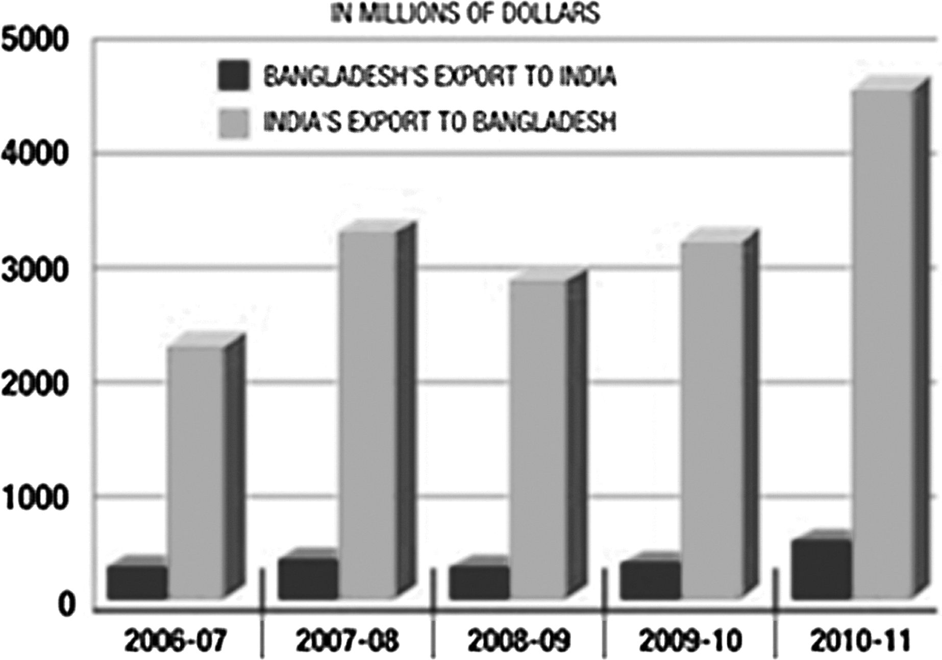
Bilateral trade gap between India and Bangladesh. Source:
India, which has clearly demonstrated water piracy, established the International Water Institute and observes World Water Day. Scientists in India take leading roles in organizing international meetings and workshops related to human dimensions of global change. Such actions seem to be good publicity for demonstrating philanthropic work to mask the suffering and impact that has been caused for Bangladesh.
Depriving humans and other living beings of water is a grave violation of their rights. While the United Nations establishes and emphasizes aims to save diversity, a prospective permanent member to the Security Council pursues actions that produce the opposite effects. Such a UN Security Council member has already proved to have provided insecurity through her ambitious actions for obtaining permanent natural resources from small neighbors. She is disqualified for her track records.
Revision of the definition of GDP
Historically, there have not been any instances of stealing any country's natural resources by other countries. Even in instances of colonialism, which flourished in the past, colonial powers did not rob basic resources from any colony. In calculation of a country's GDP, permanent resources, like land, air, and water, were never part of the evaluating formula. However, India's recent actions have forced experts to redefine GDP. The GDP of a country that is losing or has lost natural resources cannot be compared with that of a country that is gaining or has gained natural resources.
Indo-Bangladesh relations
India assisted Bangladesh in the fight against Pakistan in emerging as an independent state, but under India's command.80 The Indian army looted materials from Bangladesh, including heavy military weaponries from cantonments, laboratory stopwatches from educational institutions, and ornamental plants in tubs from student dormitories. India quickly captured the market of 150 million Bangladesh people in the arenas of Indian goods, education and training, medical treatment, tourism, visitation of religious and sacred places, culture and recreation, and so on. The jute industry was destroyed in Bangladesh, and the garment industry is currently suffering. The Indian border security force has proven to be the world's top border terrorist force in terms of killing innocent Bangladeshis, and a thorny wire fence has been implemented around the Indo-Bangladesh border. Indian political leaders used to say in their National Assembly that if India has one piece of bread, half would be reserved for Bangladesh. However, India's current exploitation of Bangladesh appears to continue to grow.
In comparison, the UK helped in the establishment of Israel, but the former has never exploited the latter. In 1994, the U.S. assisted Israel with $3 billion, and Israel was the top country in getting assistance from the U.S. In 2004, Israel received $2.62 billion from the U.S. as assistance.81 In return, the U.S. never exploits Israel. Additionally, Australia does not exploit East Timor. These cases should serve as examples for India's strategies and policies for Bangladesh and will likely and eventually have impacts on Bangladesh's future.
Rob Peter not to pay Paul but to lend Paul
Indian dams and barrages are an enormous investment for India. While initiators of a state's birth offer assistance for her development, India lends money to Bangladesh at a very high interest rate for river dredging. India benefits in multiple ways: water piracy aids in the growth of food, enhances port navigability, sets up top waterways for cruise travel, grants high interest-bearing loans to Bangladesh for dredging her rivers and canals clogged by the water piracy, and sells food grains at a higher price even after fixing the sale price to tornado-affected Bangladesh. She adds the new proverb “Rob Peter to Lend Paul” on top of the proverb “Rob Peter to Pay Paul” in the language arena.82
Another suffering neighbor of India
Like Bangladesh, Pakistan's rivers also have sources in India (Figure 14). According to the Indus Treaty, Pakistan gets water from the Chenub River (Figure 14).83 In 2008, India built the Baglihar Dam upstream of the river and has reduced its discharge. In 2005, Pakistan complained to India about the construction of the dam.84 The Indus treaty allows India to store 10,000 acre-ft water in the upstream reservoir on the Jhelam River (Figure 14), but instead 750,000 acre-ft water is stored.85 India changed the course of the Kishenganga River (Figure 14) by building a 37-m high dam, and reduced its wintertime discharge to one-third. India plans to generate 330 MWt power from the Kishenganga Project, which intereferes with Pakistan's hydroelectric plant downstream. India does not respond to Pakistan's proposal for settlement through arbitration.86 The Sutlej River is a tributary of the Indus, and supplies water to Cholistan in Pakistan's Bahawalpur Division. The total number of operational, under-construction, and planned dams in the Sutlej basin is 30 (Figure 15).87 The Beas River is a tributary of the Sutlej River, and has a basin of 20,383 sq km.88 India built dams in Kashmir and pirates additional water from the Jheelum and Chenub Rivers. The Beas and the Sutlez Rivers have been made dry and the Ravee River is partially dry.89
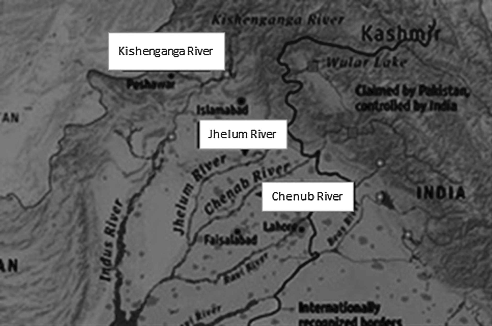
Pakistan's rivers, too, have origins in India. India built dams on these rivers upstream in Kashmir. Source: <

Indian hydroelectric projects in the Sutlej basin. Source:
Recommendations
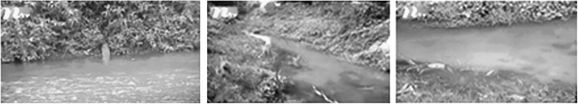
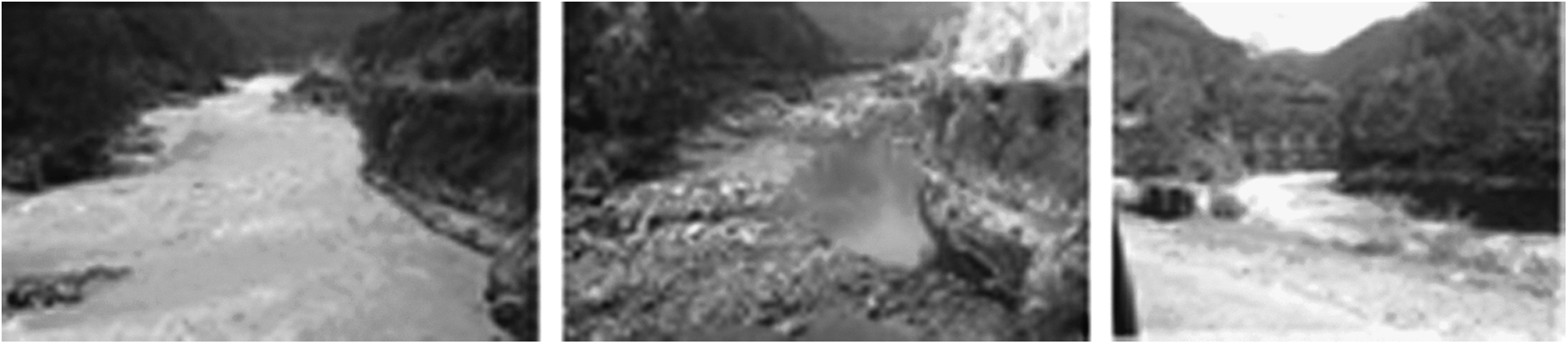
The ecosystem in Bangladesh did not develop under water scarcity but under water abundance, thus a 60% water loss has a profound impact. The water shortage that has been decades in length has produced irremovable scars on the ecosystem's living and non-living elements. Ecocide effects have been mentioned in previous sections. In a civilized world, such inhumane actions cannot be tolerated. Water is the most vital element of an ecosystem. Bangladesh's initial patient and accommodating approach to India was not successful in the past. It is time for Bangladesh to stand strong and hold India responsible for the ecocide in the Ganges basin. For the revitalization of the downstream ecosystem, several steps must be initiated by India. First, the earnings from decades of investing the pirated water should be given to Bangladesh in a retrospective effect. Profits have been made in improving Calcutta Port's navigability and establishing the nation's No.1 waterways for cruise lines. Next, India should bear the cost of dredging the downstream Ganges basin's clogged rivers and canals to make water accessible to interior floodplains, ponds, and other low lands to set up the wetland ecosystem again. Over decades of water shortage, these abandoned channels that used to annually discharge trillions of gallons of water to inland floodplains and other surface water bodies are almost obliterated (Figure 16).90–93 Finally, the feeder canal should be closed, the Farakka Barrage and all other water piracy constructions around Bangladesh at the upstream of the international rivers demolished, and the looted water resources returned to Bangladesh.

Top row: A huge shoal at the origin of the Ganges's primary distributary the Baral (left) (courtesy of Samad and Adel); the Baral's clogged mouth (middle) (courtesy of Samad and Adel), the Baral's condition in its mid-course (right) (courtesy of the daily Amardesh. Middle row: The Baral turns to the right and the secondary distributary Musa Khan to the left (left) (courtesy of Google); the clogged mouth of the Musa Khan (middle) (courtesy of Samad and Adel); a mid-course condition of the Musa Khan (right). (courtesy of Samad and Adel). Bottom row: A culvert over a decades-long clogged canal from the Musa Khan to carry water to interior floodplains (left) (courtesy of Samad and Adel); groundwater is extracted in a dry floodplain for rice cultivation (middle) (courtesy of an anonymous photographer); rice planted in the author's dry family pond (right) (courtesy of Samad and Adel), the deepest pond of the locality that served dozens of families in pre-piracy period turned dry.
With the depletion of surface water resources, groundwater has been the only hope for the people in the affected basin. Due to over-extraction and over-dependence with little or no recharging, the groundwater is almost depleted. In pre-piracy days, the groundwater was available within 5 to 8 m; in post-piracy days, groundwater is not available even in 20 m depth. It is being depleted very quickly in the presence of little or no recharge. Arsenic contamination of the groundwater in the Ganges basin, the world's worst man-made disaster (Figure 17),94 is the result of the upstream water piracy and lack of groundwater recharging.36 Groundwater recharging is a very slow process, and it is India's obligation to bear the cost of the groundwater's full recharge up to the phase of regaining self-purification feature from arsenic and the cost of arsenic purification of the water in Bangladesh until that phase is regained. Furthermore, India should be responsible for the cost of treatment of the millions of people living under the risk of arsenicosis as well as those who are suffering from arsenicosis. A 20% fatality rate in Bangladesh is related to arsenic contamination of the groundwater.95 India should compensate for the fatalities.

Arsenic patients with burning sores, one of the worst curses of the upstream water piracy. Source: Courtesy of
The water shortage has caused irregular and scanty rainfall in the affected areas, and India should assist Bangladesh with the lost food grain production due to lack of rain. With the depletion of the surface water resources, 109 species of the Gangetic fishes are no longer locally produced in about 900 sq km of the Musa Khan basin and a few times more area in the Baral River and other affected river basins. People suffer from calcium and protein deficiency due to unavailability of fish. To preserve environmental justice, it is India's obligation to make up for these deficiencies. Further, India should bear the cost for the rehabilitation of hundreds of poor people whose livelihoods were directly and indirectly affected by the lost water resource.
The maximum summertime temperature rose from 98.6°F to 109.5°F, and the average temperature of 87.8°F rose to 90°F in the post-piracy period, and the heating degree days increased by 1.33-fold. The wintertime minimum temperature dropped from 46.6°F to less than 41°F and the average temperature dropped from 78.8°F to 77°F in the post-piracy period, and the cooling degree days increased by 1.44-fold. Annually, about 70 thousand million billion calories of heat warm the environment during the summertime in the absence of the water resources, a natural heat retainer. The environment loses the same amount of heat due to lack of water in the post-piracy period. Along with this, the light rainfall frequency has increased, but the heavy rainfall frequency has decreased by approximately 50%.18,20 Other than causing crop failure, the generation of extreme climate conditions causes environmental diseases, such as hypertension, heart diseases, asthma, and more. India should provide treatments and compensation for the victims and fatalities that occur in the winter.
The reestablishment of the wetland ecology and its flora and fauna in the downstream ecosystem will be a time-consuming process, like the recharging of the groundwater. India should bear the cost of reestablishing the flora and fauna. In the wake of the Ganges' dwindling discharge, there has been inland intrusion of the salinity front. India should be responsible for the desalinization of surface and groundwater in the coastal areas and in the interior. The loss of sediment deposition in the coast from river discharges has caused increased erosion of the coast.96,97 India should also be responsible for rebuilding the coast. Water should no longer be stolen, and instead the stolen water should be returned to Bangladesh in the dry season. Indian strategy by the border area rivers causes erosion to the Bangladeshi bank side of the rivers and changes the map of Bangladesh. Islands formed in the rivers from the eroded land mass as well as the Bangladeshi land submerged under waters in the rivers are occupied by India. India should stop this practice and return the occupied land—both island and underwater land—to Bangladesh. All costs concerned should be paid in retrospective effect. It is time for India to acknowledge committing these environmental crimes in the international forum. Altogether, the results of water piracy against Bangladesh have caused losses of astronomical figures.
Bangladesh should approach the international court to get full compensation from India and receive environmental justice. Assisting in the struggle for independence does not authorize any country post-independence exploitation. Taking advantage of a country's basic resource is worse than weapons of mass destruction; the former causes gradual ecocide through untold sufferings, and the latter locally takes toll of lives and properties almost instantaneously. Indian actions have turned Bangladesh vulnerable to natural disasters rising inland and in-sea by weakening her natural internal immunity as noticed from their increased frequency of occurrences.
Conclusion
In post-partition days, India prioritized the development of other ports because of losing port-supporting wider raw material producing areas. The loss of the navigability of the Calcutta Port was due to damming the tributaries and the sub-tributaries of the Hooghly for storing water in their basins, if the loss really occurred. However, India's delayed action on the dredging cost estimation does not prove decisively that the port's navigability was an immediate need to pirate the downstream ecosystem's water. The interval between the false aim of regaining the lost navigability and the proposal for consideration of silt removal spans a few decades. This does not prove that the pirated water solved the navigability loss problem. Rather, the pirated water was for investment in the establishment of the Indian national No. 1 inland waterways across India for commercial use. Bangladesh was cornered to consent to India's water piracy right, for her ecosystem's least survivability. India's cruise line setup at the distress of Bangladesh is seemingly an excellent example of “what is sport to the cat is death to the rat.” India's robbing of the Bangladesh Ganges basin ecosystem's water continues without regard to the state of the ecosystem. India pursued water piracy from the downstream Ganges basin by locking Indian water resources of the Hooghly River in reservoirs, and diverting water from one river basin to an unconnected river basin. India's observation of World Environment Day, Word Water Day, the setup of the International Water Institute, and the claim of aiding third world countries contradict with her practice of subjugating small neighbors by remote controls.
India's membership in the Ramsar Convention may be meaningful if India begins to immediately reestablish the lost ecosystem in Bangladesh by the following: (i) retrospective payback to Bangladesh for the earnings India made by investing pirated water resources; (ii) bearing the cost of dredging the Ganges and its primary, secondary, and tertiary distributaries and their canals and ponds in Bangladesh; (iii) closing the feeder canal linking the Ganges with the Hooghly; (iv) demolishing the Farakka Barrage and all other operational, under-construction, and planned water piracy constructions upstream of the Indo-Bangladesh border; (v) returning the stolen water resources to Bangladesh; (vi) shouldering the cost of a full groundwater recharge; (vii) paying off the costs of groundwater purification until it regains the natural cleaning; (viii) bearing the cost of the treatment of arsenic patients and compensation for the fatalities; (ix) retrospective compensation for crop damage from the extreme weather; (x) paying for treatments of patients suffering from environmental diseases and mass malnutrition; (xi) paying for the cost of the reestablishment of the extinct aquatic and amphibian habitats, other habitants, and other flora and fauna; (xii) paying for the rehabilitation of those who lost their livelihoods; (xiii) bearing the cost of desalinization of the inland and coastal surface and groundwater bodies; (xiv) rebuilding of the coast; (xv) compensation for the loss of lives and property from increased vulnerability to natural disasters like tornadoes, increased lightning-hit deaths, and unexpected floods that are caused by the sudden Indian release of unaccommodating flood water in the silted rivers at the upstream, by opening the gates in their dams and barrages surrounding Bangladesh; (xvi) the above enlisted sequential compensations for all other affected river basins (shown in Fig 5) in Bangladesh; and (xvii) the return to Bangladesh of the river islands formed in border area rivers and Bangladeshi eroded land masses in rivers due to the Indian strategy of causing Bangladeshi-side river bank erosion.
Bangladesh's GDP calculation needs to include the lost natural resources and the scenarios that evolved in order to more accurately be compared with other nations. Bangladesh should approach the International Court for full compensation from India in the event India overlooks the recommendations. Sufficient evidential documents fully authenticate the case of Bangladesh. Assistance during war does not authorize post-war exploitation. Although led by her own interests in Bangladesh's struggle for an independent nation, India would have remained an esteemed nation to Bangladeshis if India had not pursued exploitation and suppression of Bangladesh. Talks on the ecocidal effects of the Gangetic Bangladesh are attempts to restore environmental justice, and are not propaganda against India.
Footnotes
Acknowledgments
The author is thankful to the persons and/or agencies whose illustrations and facts have been used in this article.
1
Sattar, A. 1998. Bangladesh-Bharat Ovinno Nodir Pani Sankat (Bangladesh-India Transboundary River Water Crisis), Tofazzal Hossain Bishwa Sahitya Bgavab, 38/4 Bangla Bazar, Dhaka-1100, Bangladesh.
2
Courtesy of <
3
<
4
Courtesy of <
5
Courtesy of Google.
6
Courtesy of <
7
Cole, C. V. and P. P. Vaidyaraman, 1966. Salinity distribution and the effect of fresh water flows in the Hooghly River, Proceedings of 10th Conference on Coastal Engineering, Tokyo, Japan, p. 1423.
8
Courtesy of B. M. Abbas, A. T. 1996.
9
FAO. 1988. Agro-ecological regions of Bangladesh, FAO, Rome.
10
Akonda, A.W. 1989. Wetlands of Bangladesh, in Scott, D. A. (ed.), A Dictionary of Asian Wetlands, International Council for Bird Preservation: International Waterfowl and Wetlands Research Bureau.
11
Khan, A. A. 1993. Freshwater wetlands in Bangladesh: Opportunities and options, in Ainun Nishat et al. (eds.), Freshwater Wetlands in Bangladesh: Issues and Approaches for Management, IUCN-The World Conservation Union, Dhaka, Bangladesh.
12
Adel, M. M. 2001. Effect on water resources from upstream water diversion in the Ganges basin, Journal of Environmental Quality, 30:356–368.
13
Courtesy of Hossain et al., 2001.
14
Dugan, P. J. (ed). 1990. Wetland Conservation: A Review of Current Issues and Required Action, IUCN, Gland, Switzerland.
15
IWRB. 1992. Action Program for Conservation of Wetlands in South and West Asia. Northeast Regional Water Resources Development Project (FAP 6), 1992. Draft Thematic Study, Regional Water Development Status, Flood Plan Coordination Organization, Government of Bangladesh, Dhaka.
16
Adel, M. M. 1999a. The impact of climatic extremes and water shortage upon human health, World Resource Review, 11(4):576–601.
17
Adel, M. M. 199b. Integrated investigation of the arsenic episode in Bangladesh, Indian Journal of Environmental Protection, 19(9):652–660.
18
Adel, M. M. 2000a. Microlevel climate change in the Ganges basin, Journal of the Arkansas Academy of Sciences, 53:83–91.
19
Adel, M. M. 2000b. Arsenic contamination in the groundwater of Biosphere III: causes and remediation, pp. 71–80, in H. Inyang and V. Ogunro (eds.), Proceedings of the Fourth International Symposium on Environmental Geotechnology and Global Sustainable Development, Boston, MA.
20
Adel, M. M. 2002. Man-made climatic changes in the Ganges basin, International Journal of Climatology, 22:99–1016.
21
Adel, M. M. 2003. Biosphere III: The site of unprecedented ecocide in the Ganges basin, pp. 59–79, in J. Ahmed (ed.), National Documentation on the Problems of Arsenic and Farakka, published by the International Farakka Committee, Inc., New York, NY.
22
Adel, M. M. 2004a. Impacts from trans-boundary water rights violations in South Asia, pp. 205–214, in R. Murray, K. Jacobson, and S. Anderson (eds.), Proceedings of the 2004 Water Management Conference: Water Rights and Related Water Supply Issues, Salt Lake City, UT.
23
Adel, M. M. 2004b. Upstream water diversion constructions on transboundary rivers, pp. 547–556, in R. Murray, K. Jacobson, and S. Anderson, eds., Proceedings of the 2004 Water Management Conference: Water Rights and Related Water Supply Issues, Salt Lake City, UT.
24
Adel, M. M. 2005. Background state leading to arsenic accumulation in the Bengal basin groundwater, Journal of Water and Health, 3(4):435–452.
25
Adel, M. M. 2008a. International migration of Gangetic fishermen in South Asia, International Conference on Environment, Forced Migration and Social Vulnerability, Bonn, Germany, October 9–11, <
26
Adel, M. M. 2008b. Natural river flow obstruction risks groundwater arsenic contamination, UNESCO-Sponsored International Conference on Water Scarcity, Global Changes and Groundwater Management Responses, University of California at Irvine, California, December 1–5, <
27
Rashid, M., J. J. Pereira, R. A. Begum, S. Aziz, and M. B. Mokhtar. 2011. Climate Change and its Implications to National Security, American Journal of Environmental Sciences 7(2):150–160.
28
Miah, M. A. 1995. Integrated effects of water diversion, pp. 23–24, in FOBANA Conveners (eds.), Proceedings of 8th Annual Convention of the Federation of Bangladeshi Associations of North America (FOBANA), Montreal, Canada.
29
Miah, M. A. 1996a. The water crisis in Bangladesh: A challenge to integrated water management in urban areas, Environmental Research Forum, 3–4:69–86.
30
Miah, M. A. 1996b. Ecocide in the Ganges basin, The Message, May 1996, pp. 13–14.
31
Miah, M. A. 1996c. Farakka Barrage: An unprecedented environmental disaster in the Ganges basin, pp. 18–31, in T. S. Rehman (ed.), Perspectives of the Thirty-Year Water-Sharing Treaty, Bangla Bazar Publisher, Dhaka, Bangladesh.
32
Adel, M. M. 2008c. Ordeals to have due share of trans-boundary river water, UNESCO-Sponsored International Conference on Water Scarcity, Global Changes and Groundwater Management Responses, University of California at Irvine, California, 1–5 December, <
33
Adel, M. M., 2012a. Jaladasyuta (in Bengali), The Weekly Thikana, 23(2), February 24, pp.163–169.
34
Adel, M. M. 2012b. Ecosystems sustainability challenges from international river water plunderage, pp. 58–66. in S. Rab (ed.), Proceedings of the 3rd ABC Convention, Astoria World Manor, Astoria, NY, June 23–24.
35
Adel, M. M. 2012c. Downstream ecocide from upstream water piracy. Am. J. Environ. Sci., 8:528–548. DOI: 10.3844/ajessp.2012.528.548.
36
Adel, M. M. 2013a. Upstream water diversion contaminates downstream water, Environmental Justice 6(3):103–114. Mary Ann Liebert, Inc. DOI: 10.1089/env.2013.0008.
37
Adel, M. M. 2013b. Jaladasyupana (Water Piracy) (in Bengali), Dibbo Prakash, 32/2 Khan Bangla Bazar, Dhaka-1100, Bangladesh.
38
Sattar, A. 1996. Farakka Bangladesher Bhagyo Zekhane Bondi (in Bengali), Padma-Jamuna Prakashani, Dhaka, Bangladesh.
39
John Berns, New York Times, May 25, 1997, mentioned in Sattar's Bangladesh-Bharat Abhinna Nadi Sankat (see note 1).
40
<
41
Hebblethwaite, G. 1997. The impact and implications of the Farakka Barrage upon Bangladesh. B. Sc. Thesis. Newcastle University, UK.
42
Courtesy of Salahuddin, 1996.
43
Courtesy of Jebouni and Sadequl, December 2011.
44
<
45
Indian Act No. XIV of 1948.
46
<
47
Jain, S. K., P. K, Agarwal, and V. P. Singh. 2007. Hydrology and Water Resources of India, 57:395. Springer.
48
Parakas, A. 1998. Farakka Barrage: Cause for Concern [Online], Available at <
49
<
50
<
51
<
52
<
53
<
54
<
55
<
56
<
57
<
58
<
59
<
60
<
61
<
62
<
63
<
64
News From Bangladesh, February 2, 2010.
65
Adel, M. M. 2012d. Mamateedeer Matha Batha Hooghly-Gangar Sanghare na Farakkar Fatole (Mamata's Headache Lies not the Killings of the Hooghly and the Ganges, but in the Farakka's Cracks), The Weekly Thikana, April 13, New York, NY.
66
Personal communication, with Ali Imam, Civil Engineer, 2012.
67
Crow, B., A. Linquist, and D. Wilson. 1995. Sharing the Ganges—The Politics and Terminology of River Development. University Press Limited, Dhaka, Bangladesh.
68
Bindra, S. S. 1982. Indo-Bangladesh Relations. Deep and Deep Publications, New Delhi, India.
69
Patel, T. 1996. Bridge Over Troubled Waters, New Scientist, 152(2058):12–13.
70
Business Line, October 25, 2011.
71
<
72
Courtesy of NTV, a television broadcasting station in Bangladesh, 2011.
73
Jain, S. K., P. K. Agarwal, V. P. Singh, 2007. Hydrology and Water Resources of India. 57:395. Springer.
74
Jhunjhunwalla, B., 2009. Economics of Hydropower. 1st ed., p. 306. Kalpaz Publisher, Delhi, India, ISBN-10: 9788178357409.
75
Hillary, E. S. 1979. From Ocean to the sky. p. 35. Viking Publishing Co., New York, NY.
76
Brown, L. R. 1991. The Aral Sea: Going, Going … , World-Watch Institute, January–February.
77
<
78
<
79
80
Bharati Hosse Bangladesher Mool Samasya (India is at the root of all problems in Bangladesh), The Weekly Thikana, June 14, 2013.
81
<
82
Adel, M. M. 2012e. Goru Mere Juta Reen (Rob Peter to Lend Paul), The Weekly Thikana, February 21, New York, NY.
83
<
84
<
85
<
86
<
87
<
88
<
89
<
90
Courtesy of Samad and Adel.
91
Courtesy of the daily Amardesh (a Bengali daily published from Dhaka, Bangladesh).
92
Courtesy of Google.
93
Courtesy of an anonymous photographer.
94
Courtesy of <
95
The University of Chicago Medicine Communications, <
96
Adel, M. M. 2013. Treeteo Jibjagat (Bio-world III), (in press), Dibbo Prakash, 32/2 Khan Bangla Bazar, Dhaka-1100, Bangladesh.
97
Wasson, R. J. 2003. A sediment budget for the Ganga-Brahmaputra catchment, Current Science, 84(8), April 25.