
Abstract
Abstract
Newspapers are underused as a source of spatial data in environmental justice research. Recent advances in qualitative historical geographic information systems (QHGIS) provide an opportunity for deeper investigation into how newspapers reflect changing meanings of place in relation to environmental burden and environmental benefit. This article introduces a protocol to identify and map locations associated with different media frames. We apply QHGIS to urban gardening and soil lead issues reported in Sacramento, California. We find that the QHGIS method enhances conventional approaches to case study archival research and media analysis because it reveals: (a) the distribution of public narratives of environmental concern across the city, (b) the politics embedded in location names, (c) place name-changes that might otherwise lead to inaccurate GIS analysis, and (d) how locations can be used as a framing device to communicate environmental concerns. The method can enhance research in which the history and geography of enduring, emerging, and changing public understandings of place are important to contemporary environmental (in)justice debates.
Introduction
V
Qualitative historical geographic information systems offers a spatially explicit approach to analyzing framing that is appropriate to environmental justice research. QHGIS emerged as part of a larger movement toward GIS applications that are qualitative and aim to integrate spatial attributes with data sources, like newspapers, that are typically analyzed outside of a strict positivist epistemology. 6 While both newspaper analysis 7 and geographic information systems 8 have been prominent methodologies in environmental justice scholarship, they have not been used together.
Creating a QHGIS of the locations identified as places of environmental burdens and environmental amenity can help to inform theoretical debates about how the scale of environmental justice activism changes over space and time. 9 For example, newspapers may link several locations or consistently link a single location to a particular environmental justice concern. While both indicate high levels of public awareness of the concern, the approaches construct the spatial extent and severity of an issue very differently. Further, the physical locations under consideration alone do not capture the meaning of place. Rather, it is captured in the location and the context provided by the newspaper text together. For example, a media frame that diffuses attention across many locations could limit public awareness of a problem or organize larger public support to address an issue. Similarly, persistent association of a single location with environmental burden could be stigmatizing and isolating, but could also serve as a focusing event for organizing the community. Both spatial and contextual information is necessary to interpret the meaning of the media frames.
We examine how the specific location changes in identity as the narrative about the location unfolds. The public narrative surrounding urban soil is especially relevant to environmental justice because of the potential for soil to harbor both burden and benefit. Disproportionate exposure to and adverse health effects from high lead concentrations in urban soils helped coalesce early environmental justice activism. 10 In its early decades environmental justice activists worked to resist toxic hazards and reduce environmental burdens in low-income communities and communities of color. 11 As ideas of environmental justice matured, advocacy for urban gardens and other environmental benefits became a larger part of environmental justice. 12 Environmental lead and urban gardening are linked through soil, which creates uncertainty about the best way to manage trade-offs between potential burdens and benefits. 13 Thus, the variation in how people perceive soil and the way positive and negative perceptions are distributed through the city matter to the construction of place as much as biophysical reality. The frame (e.g., association with benefit or burden) can change the meaning of locations. 14
Approach
We analyze newspaper articles focused on urban environmental lead and/or gardens that address environmental justice themes. The focus was Sacramento Bee (the Bee) coverage of environmental lead concentrations and urban gardening between 1984 and 2013 in Sacramento, California. The Bee is the predominant daily newspaper and currently reaches 61% of adults in Sacramento each week. 15 We use a qualitative coding protocol, inspired by Taylor, Arrowsmith, and Cook, 16 to identify locations mentioned in newspaper articles (Figure 1). Two coauthors coded articles for relevance to environmental justice (Cohen's kappa = 0.86; n = 30 cases) using Sze and London's 17 review of environmental justice definitions. Articles with no relevance to environmental justice, or that did not take place in Sacramento, or were not about soil lead or gardens were excluded from the analysis. We created a database of relevant articles using Access World News. 18
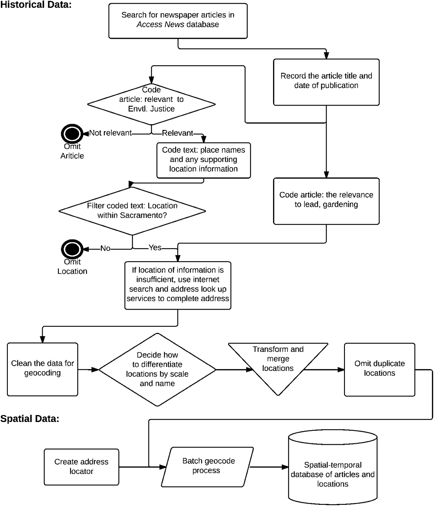
Flow diagram associated with QHGIS method. Shapes indicate different phenomenon: Squares are a human process, diamonds are decision points, triangles are merges, parallelograms represent data processes, and the bucket connotes the final database.
Within each article, coders identified each location referenced. We assigned the most specific location possible in order to geocode locations using street addresses, cross streets, nearby intersections, or landmarks. We confirmed the locations of places referred to by name (e.g., Mandella Garden), using additional Internet searching to make decisions about whether and how to combine alternative naming conventions that appeared to apply to the same location (Table 1). Each article could be linked to several locations within Sacramento, but only linked to a single location once.
Note: All locations are in Sacramento, CA USA; *location that is directly involved in garden controversy.
Results
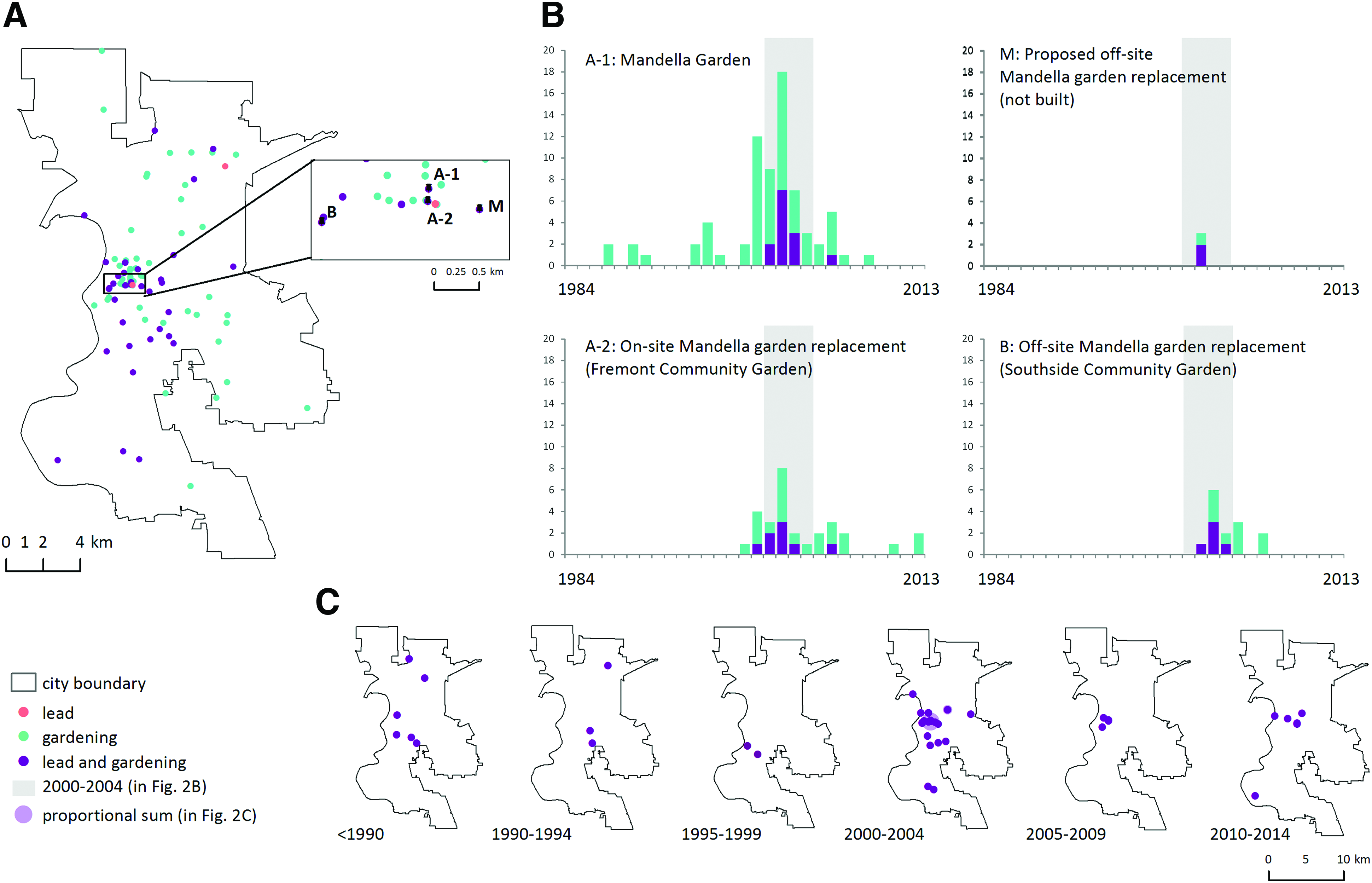
The spatial distribution of locations extracted from newspaper coding over time highlights the prominence of gardening articles in comparison to lead or lead and urban gardening together (Fig. 2A). Framed as places of burden and benefit, these places highlight contested and dynamic negotiation of urban place identity (Fig. 2B).
Locations mentioned in the article database as distributed (
Generating spatial location from newspapers highlights the politics of spatial and temporal dimensions of environmental conflict. Documenting differences in naming (Table 1), allowed us to quantify location information across naming conventions and reveal places of controversy. The most common locations are associated with controversy over a particular community garden (location A). 19 We divided references to this location into two locations (A1) and (A2) because of differences in size. Location A1 refers to a larger land area and is mentioned in 72 articles. A2 is approximately 1/3 the area and is mentioned in 29 articles. We used differences in the spatial extent to separate locations. This reflects the reality of the displacement of the initial garden (Fig. 2 location A1) in 2002 and a new garden established on one-third of the area of the original garden (Fig. 2 location A2).
The locations framed in relation to both lead and gardening tells the story of the active negotiation of the city's environmental identity. The highest level of conflict between soil lead and urban gardening occurs in the city center and during the period from 2000–2004 (Fig. 2C). The conflict centers around 14th and Q Streets, mentioned in 101 articles (Fig. 2A-B) and associated with multiple place names that were ultimately separated into two distinct locations (labelled A1 and A2). The conflict links these locations with others that are mentioned frequently, including locations B and M, where new gardens were proposed to replace the area lost from location A1 (Fig. 2A-B).
In a few cases, our coding revealed that the location associated with a particular name changed over time. For example, the Southside Community Garden changed locations from location A in in 1984 to Location B in 2006 (Table 1). Together, changes in names and their association with locations highlight the importance of QHGIS to maintain a historical perspective on environmental conflicts that may be lost otherwise.
Last, we find that locations can be used as framing devices by protagonists in environmental conflicts. Location A1, or the Mandella Garden, is mentioned more frequently than other gardens in the city, despite its replacement by Location A2 in 2004. References to this site are made by participants in the conflict as part of the framing of urban gardening in relation to social resistance and environmental benefit protection. For instance, a 2011 piece about changes in urban agriculture ordinances said: “Let [the history of the Mandella Garden] be a lesson as we move forward with the current ordinance. Supporting sustainable urban agriculture in Sacramento will mean dealing with the realities of redevelopment, public land, and people's rights” 20
Discussion
By using QHGIS to glean spatial and temporal information embedded in newspapers, we provide new insights through visualization of data patterns and changes over time. In our case, cataloging the diverse names assigned to location as well as their spatial extent enabled better searches through public records and other databases. 21 On its own, QHGIS analysis of environmental justice cannot identify mismatches between media attention and either biophysical risk or social vulnerability. Yet, QHGIS is important to understanding why some local environmental justice struggles are able to jump scales and become important to the city (or larger) scales and others are not. 22 QHGIS does however enable researchers to map media frames alongside spatially explicit biophysical data and/or individual-level social data making it a valuable addition to case study research.
Conclusion
The QHGIS approach we introduce addresses the need of many environmental justice researchers to understand how place meaning is created and modified through public narratives. The ways that locations are enrolled in discussions of environmental benefit and burden matter because they reflect material realities and the meanings of place. Changes in the framing about gardens and soil lead illustrate environmental struggle and a larger social process that acknowledges the rights of residents to a clean and healthy environment while also legitimizing concerns about environmental contamination.
Footnotes
Acknowledgments
We gratefully acknowledge support from the University of California, Division of Agriculture and Natural Resources competitive grants program (No. 11-958). Work by Danqi Fang and Kaitlyn Hornik was supported by the National Institute of Food and Agriculture, U.S. Department of Agriculture, under award number ILLU-875-919.
Author Disclosure Statement
The authors have no conflicts of interest or financial ties to disclose.