
Abstract
Abstract
In Charleston, SC, the planned expansion of the Port of Charleston may add to the cumulative impact of environmental pollution in communities already overburdened by Superfund sites, brownfields, leaking underground storage tanks, toxic release inventory facilities, a coal-fired plant, an old incinerator site, and diesel truck traffic. A community–university partnership led by the Low Country Alliance for Model Communities was established to assess baseline pollution levels of trace metals in soil near industrial pollution sources and heavily trafficked roadways before the port expands. The research team trained residents as citizen scientists to collect soil samples (n = 150) near these environmental hazards in Union Heights (UH), Accabee, Chicora-Cherokee, Green Grove, and Rosemont (RM) in June 2012. Soil samples were examined for the presence of arsenic, barium, beryllium, cadmium, chromium, copper, iron, lead, magnesium, manganese, mercury, nickel, and zinc. Arsenic, lead, and mercury levels were found to be elevated, with arsenic levels being more than U.S. Environmental Protection Agency (EPA) residential screening levels (RSLs) for health risks. The mean concentrations for arsenic across each study neighborhood ranged from 1.8 to 7.4 mg/kg compared with a RSL of 0.39 mg/kg. In addition, we assessed the spatial relationship between concentration of each metal and proximity to two Superfund sites. UH and RM had the highest mean metal concentrations possibly because they are located closer to the Superfund sites than other neighborhoods. In addition, we found statistically significant negative correlations between mean metal concentrations and proximity to the two Superfund sites with the highest correlation between chromium and the Macalloy site (−0.61). This study indicates the presence of many metals in residential soils near environmental hazards in Charleston. The results also reveal the need for more research to understand cumulative exposure to these metals and related health effects before and after the Port of Charleston expands.
Introduction
C
Metropolitan Charleston is undergoing increased expansion in goods movement, the movement of commercial goods through ship, rail, or truck. 3 The South Carolina State Ports Authority plans to open a new marine container terminal in 2019 on the Cooper River (on the site of the former Charleston Navy Base in North Charleston).
Populations near major goods movement facilities such as seaports are often disproportionately people of color and low-income communities.1, 4 , 5 , 6 These facilities may also be located near other industrial activities that may contribute to poor air quality.1,4–6 Public health impacts of goods movement activities tend to be more pronounced in areas with major transportation hubs and heavily trafficked roadways. Residents who live near rail yards, ports, and other goods movement facilities may endure high noise levels, traffic congestion, visual blight, and other negative impacts. 4 For instance, residents living near ports have elevated rates of oropharyngeal cancer and certain lung cancers, per an analysis of cancer by census tracts in Los Angeles County. 7 Residents who breathe traffic-related pollutants may have higher rates of cardiovascular disease, reduced lung function, and death.7, 8 , 9 One study found that 9% of all childhood asthma cases in Long Beach and 6% in Riverside were attributed to traffic proximity around the Los Angeles–Long Beach port complex, the largest in the United States. 6
The reduced air quality in goods movement communities in the Charleston region with heavy amounts of traffic raises health concerns. For instance, research has shown that in areas in Charleston that are more segregated, there is a higher lifetime cancer risk from air toxic pollutants due primarily to on-road traffic emissions. 10 , 11 , 12
In addition to the impacts of goods movement, the region has several toxic release inventory (TRI) facilities, chemical plants, a coal-fired plant, a paper mill, four Superfund sites, an old incinerator site, brownfields, leaking underground storage tanks (LUSTs), and two major wastewater treatment plants that discharge into Charleston Harbor, with additional upstream discharges into the Ashley, Wando, and Cooper rivers. Many of these hazards are located in North Charleston in areas with many low-income people of color. Previous research has shown that there are disparities in the distribution of TRI facilities, LUSTs, and brownfields in Metropolitan Charleston based on race/ethnicity and socioeconomic status. 13 , 14 , 15 , 16
The Low Country Alliance for Model Communities (LAMCs) built a community–university–government environmental justice and health partnership known as the Charleston area pollution prevention partnership (CAPs) to assess baseline levels of environmental contamination in overburdened neighborhoods before the Port of Charleston expands. The partnership collaborated on a community-driven effort to assess spatial and temporal variation of particulate matter near stationary sources and heavily trafficked roadways in LAMC neighborhoods before port expansion. 12 In addition, the CAPs team found that TRI facilities were located in proximity to census tracts that had a higher proportion of nonwhite and lower income residents.12,13 Residents also expressed a concern about exposure to pollutants including trace metals that may be present in soils near local hazards, including the old incinerator site and two Superfund sites. Previous research in the Charleston region has shown the presence of trace metals in soils near industrial facilities such as arsenic, lead, and chromium higher than concentrations found in rural areas. 17 Similar results in the distribution of some trace metals have been found in areas near roadways and residential lots in Baltimore and brownfields in Cleveland, OH. 18 , 19
Owing to the high concentration of environmental hazards in their neighborhoods, LAMC residents requested more data to help characterize current soil contamination levels and understand projected impacts of the new terminal and related activities on exposure and health risks to soil contaminants. In this article, we describe spatial variation in the levels of trace metals in and across LAMC neighborhoods, including spatial variation in relation to the location of two Superfund sites that impact LAMC neighborhoods.
Materials and Methods
Citizen science training in soil sampling
A group of residents from local neighborhoods were recruited with the help of LAMC leadership and the Community Advisory Board to act as citizen scientists. Participants from LAMC neighborhoods and the Rosemont (RM) community attended training organized by academic team members and GEL laboratory (the laboratory used to analyze soil samples) in proper procedures for collecting soil samples. In addition, participants received Hazardous Waste Operations and Emergency Response Standard (HAZWOPER) training from the Occupational Safety and Health Administration (OSHA). OSHA developed the HAZWOPER program to protect workers at hazardous sites. Community leadership thought it was important to obtain this training because they would be sampling near hazardous sites including two Superfund sites, an old incinerator site, and near brownfields and wanted to know how to protect their own safety and health during this study. All trainees (n = 12) had to complete the 24-hour training before they could participate in soil sampling activities.
Soil sampling process
University researchers and community members assembled a team to conduct a site assessment of LAMC neighborhoods and the RM community. In this site assessment, team members identified current sources of soil contamination, including the local incinerator site, Superfund sites, areas near known brownfields, and prioritized areas for soil sampling, including local schools, churches, and community centers. The process included taking photographs of potential sampling locations in Union Heights (UH), Accabee (AC), Green Grove (GG), Chicora-Cherokee (CC), and RM. After the site assessment, team members developed a soil assessment protocol consisting of a list of supplies, teams and roles, maps and sites, and soil collection procedures. In addition, team members received permission from local homeowners, so they could collect soil samples on their property near stationary pollution sources and heavily trafficked roadways. Sampling occurred in June 2012. Furthermore, the team followed standard soil collection quality assurance/quality control procedures to avoid contamination and ensure sample quality.
Statistical methods
Each soil sample location (latitude–longitude coordinates) was recorded using a GPS unit and logged in an Excel file. All sample locations for each study neighborhood were mapped in ArcMap 10 (Esri, Redlands, CA) (Fig. 1). There were two Superfund sites from the Superfund National Priority List in the study area: Koppers Co., Inc. (Charleston Plant) and Macalloy Corporation. Both sites were in “FINAL” status, meaning these two sites were already cleaned and, therefore, considered to be “adequately protective of human health and the environment” based on a second 5-year review for Koppers and a third 5-year review for Macalloy. 20 , 21 We obtained the latitude–longitude coordinates of the two sites and mapped their locations in ArcMap. The soil of Koppers was contaminated by polynuclear aromatic hydrocarbons (PAHs) and pentachlorophenol with trace amounts of dioxin, arsenic, and lead, and Macalloy site was contaminated with hexavalent chromium, nickel, zinc, and chromium. 22 , 23
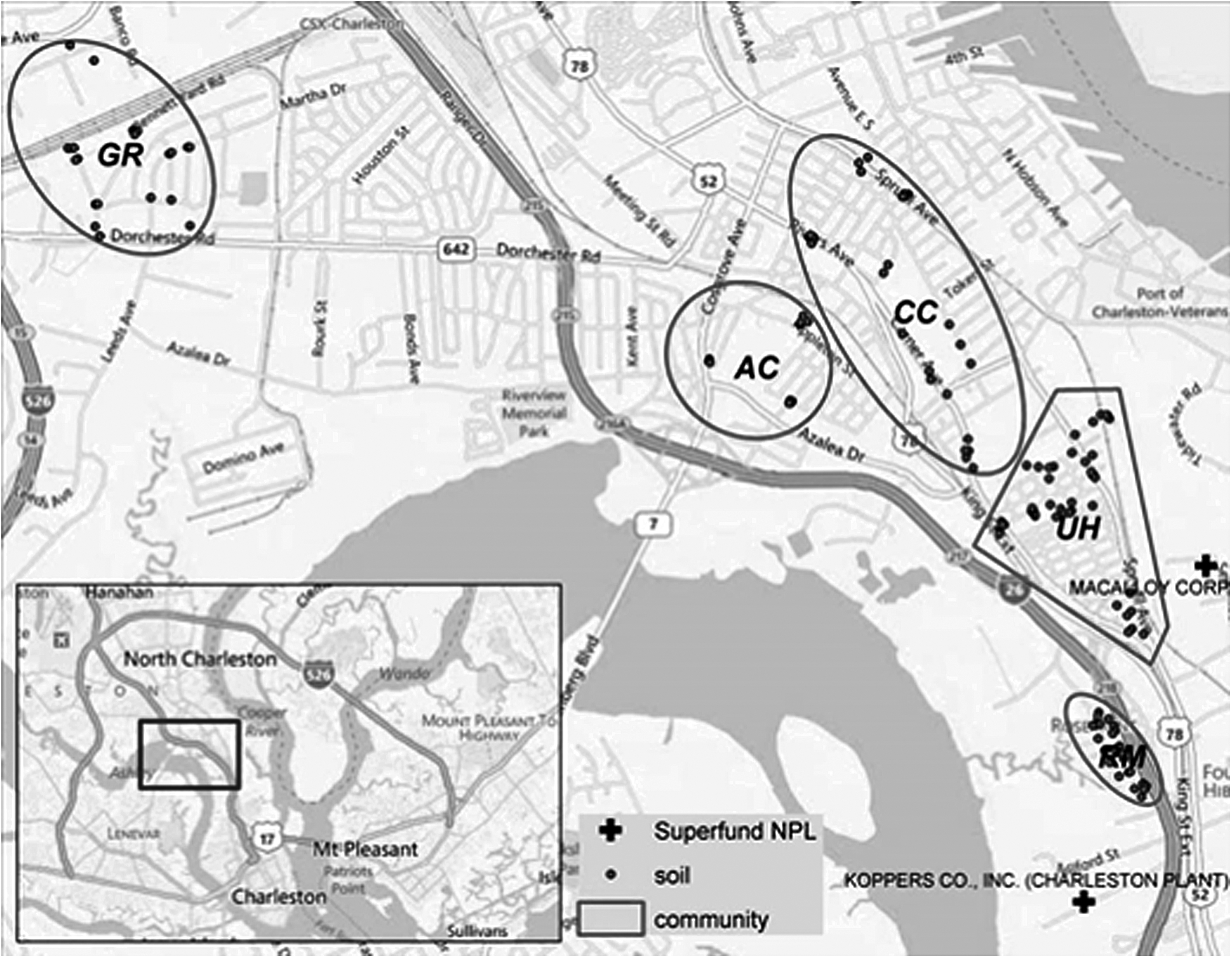
Spatial distribution of sample locations across study neighborhoods.
We assessed the association between distance to the Superfund sites and trace metal contamination. We compared mean concentrations for each trace metal within distance bands between each soil sample and the two Superfund sites. The distance bands ranged from <0.5 to 4.5 miles with an interval increase of 0.5 miles. We then pooled the data for each study neighborhood and calculated the mean, maximum, and median concentration for each metal. To ascertain potential health-related concerns for the concentrations of trace metals in each study neighborhood, the data for the trace metals were compared with U.S. Environmental Protection Agency (EPA) residential screening levels (RSLs). 24 The ANOVA test was employed to test whether contamination levels were the same across the five study neighborhoods for each trace metal. The Shapiro–Wilk test was used to test for normality and the Brown–Forsythe test was used to test the equality of variance across the five study neighborhoods. To adjust for unequal variance and lack of normality distribution, both the Welch's Test for normality and Kruskal–Wallis test for non-normality were used.
Results
Study area
Figure 1 presents a spatial overview of the locations of five communities in North Charleston where soil samples were collected. Community GR had 23 sample sites and was located farthest from the two Superfund sites. Community AC had 16 sample sites located near railways and road intersections. Community CC had 31 sample sites that ran north to south along Rivers Ave and Chicora Ave. Community UH featured 48 sample sites and near a very dense road network. Community RM had 24 sample sites. All the sites had railroads running through or adjacent to the communities as well as roads with automobile and diesel truck traffic. The black crosses highlight the two Superfund sites on the map. The cross closer to RM represents the Koppers site and the cross closest to UH represents the Macalloy site.
Statistical results
Metals and the residential screening level
Table 1 compares the mean concentration of metals found in the five study neighborhoods to their respective RSL excluding magnesium. In our comparison of the mean concentrations of metals with their respective RSL, arsenic was the only metal more than the RSL throughout all study communities. Similar mean concentrations of arsenic were collected in AC (4.6 mg/kg) and CC (4.5 mg/kg). However, both concentrations were lower concentrations for RM (7.0 mg/kg) and UH (7.4 mg/kg). The higher values obtained at UH and RM may result from their proximity to the Superfund sites. In addition, for certain neighborhoods, specifically RM and UH, the mean concentration of chromium had levels more than that of the RSL. None of the remaining metals had means higher than their respective RSL. For example, lead at its highest concentration in UH, only reached 33.25% of its RSL.
EPA, Environmental Protection Agency.
Site proximity and metal concentration
UH and RM had the highest mean metal concentrations. This is understandable considering that these neighborhoods were located closest to the Superfund sites. UH reported the highest mean levels of barium, cadmium, chromium, copper, iron, nickel, and zinc. Meanwhile RM reported the highest mean levels of lead and manganese. For all metals except mercury and manganese, GG, the neighborhood located farthest from the Superfund sites, had the lowest mean concentrations. The manganese concentration for GG was 46 mg/kg and the mercury concentration was 0.038 mg/kg, whereas AC had the lowest manganese and mercury concentrations at 44.2 and 0.036 mg/kg, respectively.
Correlation between metals and Superfund site proximity
Table 2 presents the statistical results for the correlation between trace metals and Superfund site proximity. Each correlation exhibits a moderate negative relationship at the 0.01 significance level. The strongest correlation was between chromium and the Macalloy site (−0.611). The weakest correlation was between lead and the Macalloy site (−0.245). This correlation was found not to be significant at the 0.01 level. Therefore, of all the metals, lead was the least impacted by a change in distance to the nearest Superfund site. This means that the lead concentrations measured at the various sampling sites may be attributed to other local hazards.
p-value * < 0.01 and ** < 0.001.
Table 3 presents the mean concentration for select trace metals at various distances from the two Superfund sites. The distances are represented in 0.5 mile intervals. For the Koppers site, mean concentrations of arsenic exceeded the 0.39 mg/kg RSL for each band except possibly for the 3–3.5-mile band, where no samples were taken. Both arsenic and lead followed a trend of initially increasing in mean concentration as distance from the Superfund site increased, then decreasing, increasing again, before finally decreasing. These fluctuations did not occur in the same mile bands. For example, the increase in concentration for arsenic occurred between the <0.5-mile band and the 1–1.5-mile band. In contrast, the increase in lead concentration occurred between the <0.5-mile band and the 0.5–1-mile band. Overall, the mean arsenic concentration at the 4–4.5-mile band was an 81.7% decrease from the mean concentration at the <0.5-mile band. Likewise, the mean lead concentration at the 4–4.5-mile band was a 73.6% decrease from the mean concentration at the <0.5-mile band.
For the Macalloy site, the relationship between metal concentration and Superfund site proximity was clearer. As distance from the site increased, metal concentrations decreased. The only mean concentration that did not follow the trend was for nickel. From the 1–1.5-mile band to the 1.5–2-mile band, the concentration of nickel increased from a mean of 3.1 mg/kg to a mean of 4.2 mg/kg. Meanwhile, zinc exhibited the clearest decline in concentration as distance increased. Chromium also continuously decreased, although not as steeply as zinc. Overall, the mean chromium concentration at the 4–4.5-mile band was 88.96% lower than it was at the <0.5-mile band. The mean level of nickel was about 80.42% lower at the 4–4.5-mile band than it was at the <0.5-mile band and the mean level of zinc was 83.33% lower at the 4–4.5-mile band than it was at the <0.5-mile band.
Discussion
The purpose of this study was to assess concentrations of various trace metals in soil near environmental health hazards within LAMC neighborhoods, specifically two Superfund sites and heavily trafficked roadways using community engagement and citizen science. We compared the mean concentration of each metal in each study neighborhood to their respective RSL, excluding magnesium, which did not have a RSL. Our findings demonstrated that the mean concentrations were lower than the RSLs for all metals except arsenic, which exceeded RSLs across all study neighborhoods. Mean concentrations of arsenic in Accabee (4.6 mg/kg) and Chicora-Cherokee (4.5 mg/kg) were lower than mean concentrations for Rosemont (7.0 mg/kg) and Union Heights (7.4 mg/kg). Both Rosemont and Union Heights are neighborhoods located closer to Superfund sites and port-related activities in the study area. Statistical results for correlation between trace metals and proximity to Superfund sites exhibited a generally moderate negative relationship at the 0.01 significance level. The largest coefficient was between chromium and the Macalloy site (−0.611) and the weakest correlation coefficient was between lead and the Macalloy site (−0.245).
Our review of mean concentrations of As, Pb, Cr, N, and Zn within <0.05-mile–4–4.5-mile distance bands around Superfund sites suggests that the level of contaminants decreased as distance increased from both sites. We did not sample between 3 and 3.5-mile bands at either site, nor bands between 2 and 3-mile bands at Macalloy. Moving away from Koppers site, arsenic and lead levels were approximately six and four times less, respectively. We noticed a large jump in bands from 2 to 3 miles and a similar less pronounced jump in arsenic levels. From the 1–1.5 to 1.5–2-mile bands from the Macalloy site, we noticed slight increases in nickel and a potential plateau/increase in chromium. Overall, mean levels of chromium, nickel, and zinc were 10, 5, and 6 times lower, respectively, from the <0.5 to 4–4.5-mile bands.
Our results are consistent with previous research that found higher concentrations of metals in urban areas in the Charleston region near industrial facilities using spatial assessment methodologies. 17 Previous studies have shown that there may be disparities in exposure to metals such as lead and arsenic in the state of South Carolina based on maternal race (non-Hispanic black vs. white).17, 25 , 26 This has important implications for public health in areas with high concentrations of trace metals, particularly residential areas with contaminated soils located in proximity to heavily trafficked roadways or industrial hazards such as Superfund sites. Exposure to metals such as lead, mercury, and arsenic may have negative neurodevelopmental effects for developing fetuses and young children. Several studies found an association between presence of these metals in residential soils and increased risk of intellectual disability in South Carolina. 27 , 28 , 29 There may be potential exposure and health disparities (neurodevelopment disparities) in neighborhoods near mobile sources and industrial hazards in our study area.
We had several study limitations. We only collected a limited number of soil samples in and across LAMC neighborhoods. The sampling collection periods with the citizen scientists were short, only occurring during the summer months. We also did not collect samples inside homes near hazards of concern. Furthermore, residents had expressed an interest in more intense sampling near other environmental hazards, including the old incinerator site, local brownfields, TRI facilities, a coal-fired plant, and small polluters. Unfortunately, we did not have enough citizen scientists or other resources for a larger sampling campaign. In addition, residents were interested in obtaining information about the levels of other hazardous contaminants including PCBs and PAHs, but the costs of measuring the concentrations of these compounds were too exorbitant.
In the future, we will explore cumulative exposure to multiple trace metals. Residents have expressed concerns about exposure to metals both indoors and outdoors. One approach we plan to take is to perform environmental monitoring to assess levels of metals in soils near walkways, in areas where residents are gardening, and inside homes (indoor dust). In addition, individuals can be exposed to metals through multiple routes and pathways, so the collection of blood, urine, and other biological samples may provide a cumulative measure of exposure for LAMC residents. Our future research will also include assessing the relationship between exposure to individual trace metals such as arsenic and chemical mixtures, and health outcomes including diabetes, heart disease, and neurodevelopmental effects.
Another limitation of this study was we only measured concentrations of a small suite of metals; however, future studies will examine other metals. For instance, chromium-6 exposure was a concern of LAMC members who reside near the Macalloy site, but because of analytical costs, the team did not measure chromium-6 concentrations in soil samples. In addition, we only focused on Superfund sites for our proximity analysis. Proximity analysis could be applied to brownfields, TRI facilities, LUSTs, and the old incinerator site in the study area. Additional rounds of soil sampling using trained citizen scientists will occur near these hazards to fill this gap.
Conclusion
An expansion of the Port of Charleston has the potential to increase exposure of residents to toxic contamination in goods movement communities near the proposed expansion area, communities of color who are already overburdened by TRI facilities, brownfields, LUSTs, an old incinerator site, and Superfund sites. Following a citizen science approach, we trained residents to collect soil samples to help assess baseline levels of metal contamination before the port expansion. The study found the presence of several metals in samples including Arsenic, barium, beryllium, cadmium, chromium, copper, iron, lead, magnesium, manganese, mercury, nickel, and zinc. Results indicate that the mean concentrations of trace metals were not elevated when compared with their EPA RSLs (except for arsenic). However, the results did show a negative correlation between proximity to Superfund sites and mean concentrations of several trace metals. These results emphasize a need for follow-up studies to ascertain cumulative exposure to trace metals for LAMC residents who live near a large number of environmental health hazards and any environmental health disparities associated with these exposures before and after port expansion.
Footnotes
Author Disclosure Statement
No competing financial interests exist.