




Abstract
Abstract
The present study argues for a fuller understanding of environmentally just urban planning in the context of disproportionate (in)access to “positive” environmental features as well as the preferences and perceptions local affected populations have of these environmental amenities. Because perceptions of environmental amenities influence how these resources are used and because black and Latino communities have been disproportionately excluded from the benefits of urban infrastructure development, we argue that the perceptions of these groups should be prioritized as part of an inclusive and effective amenity planning process. To unpack perceptions of environmental amenities and prioritize the voices of racial minorities in the amenity planning process, we use data collected from a Health Impact Assessment survey conducted in the Old Spanish Trail/South Union neighborhood in Houston, Texas, and focus on the proposed implementation of neighborhood greenways as a case study for environmentally just amenity planning. We find that survey respondents are significantly more likely to report greater frequency and intensity of greenway use when they are presented with a greenway map produced through a community-based neighborhood collective than when they are presented with a greenway map produced by a Houston government-commissioned corporation. Our findings also suggest that implementing neighborhood greenways, regardless of map, will increase neighborhood walkability and perceptions of intensity of greenway use in the future. We conclude with a discussion of the implications of our research for environmental amenity planning in historically marginalized urban neighborhoods.
Introduction
E
Reflecting on core concerns of environmental justice research and social movements, we argue that rather than waiting until environmental amenities have already been planned and implemented, the perceptions of local, affected populations—particularly racial minorities—should be obtained as part of a concerted, inclusive amenity planning process to maximize the impact of the intervention. 5 In general, American cities and their amenities (e.g., parks) were planned and organized around de facto or de jure racial segregation, with racial minorities and minority communities explicitly excluded from planning processes and the distribution of urban government resources funneled almost exclusively to white neighborhoods, concentrating amenities in white areas. 6 While explicit exclusion of minority communities from planning processes is now illegal, this shift in legislation has not prompted concerted and explicit inclusion of minority communities in planning processes. Prioritizing the voices of those historically excluded from access to environmental amenities—racial minorities in particular—is a crucial starting point in unpacking how to generate maximally effective environmental interventions as correctives for past and ongoing injustice(s).
To unpack perceptions of environmental amenities and prioritize the voices of racial minorities in the amenity planning process, we use data collected from a Health Impact Assessment survey conducted in the Old Spanish Trail/South Union (OST/SU) neighborhood in Houston, Texas, and focus on the proposed implementation of neighborhood greenways as a case study for amenity planning. After providing background for OST/SU within the broader Houston context, we ask and answer the following research questions: (1) How do minority stakeholders in the OST/SU neighborhood perceive their own patterns of usage for proposed neighborhood greenways? (2) What are the implications of their perceptions for the planning process?
Houston and the Ost/su Neighborhood
For much of the 20th century, Houston resembled other Southern cities in many respects. Before the Civil Rights movement, Houston was a Jim Crow city in which racial segregation of neighborhoods, public facilities, and churches was mandated by law. Houston's white elite had a vested economic interest in maintaining segregated city spaces, funneling the vast majority of city funds earmarked for urban planning, infrastructure development, and amenity building into white neighborhoods. Black Houstonians of all social classes were clustered together into several residential communities near downtown Houston—primarily Third Ward, Fourth Ward, and Fifth Ward. Over time, in addition to being excluded from infrastructure and amenity development, a disproportionately high number of solid waste sites were “dumped” in Houston's black neighborhoods. 7 After World War II and the passage of Civil Rights legislation, blacks began moving into nearby white urban neighborhoods, as well as to the suburbs. Black residents of Third Ward, for example, began moving into what had been exclusively white neighborhoods in Southeast Houston. 8 Among these neighborhoods was OST/SU. OST/SU began as a Houston suburb, but as Houston experienced massive population growth and its sprawl reached farther and farther out from the city center, OST/SU was increasingly considered part of urban Houston.
Beginning as a middle-class white community, OST/SU's vibrancy was symbolized by Palm Center, one of the first strip malls constructed in Houston. While the future of OST/SU seemed bright after the establishment of Palm Center as a hub of commercial and cultural activity in 1955, racial injustice and conflict increasingly characterized the neighborhood. 9 Recoiling against even limited residential integration, white civic clubs organized in Southeast Houston to exclude black residents. Despite this resistance, neighborhood racial turnover accelerated in the 1960s. Eventually, black migration into OST/SU and its surrounding communities reached a tipping point, after which rapid white flight ensued. By 1970, OST/SU and nearby neighborhoods had transitioned from being almost completely white to mostly black. This demographic change was immediately followed by a decline in private and public investment, resulting in neighborhood deterioration and increasingly high levels of poverty. In line with citywide patterns of racial discrimination in the provision of public services, the community lacked adequate waste disposal services, flood protection, and access to the municipal water supply. 10
Repeated neighborhood redevelopment efforts in OST/SU failed throughout the 1970s and 1980s, and the community's decline was reflected in the exodus of long-established businesses from the Palm Center strip mall. Economic growth in the area, however, has picked up in recent years. Since the turn of the century, OST/SU again began experiencing demographic change, this time with a wave of younger Hispanic residents moving in amid an aging black population. Income levels in the community are rising, and Palm Center is regaining its status as a center of commercial activity. 11
However, while many people in OST/SU walk, bike, and rely on public transportation, the area is less walkable than nearby, largely white communities such as West University Place, Midtown, and Montrose. 12 The recent construction of the Southeast METRO rail line improves the ability of residents to get to other parts of Houston more easily, but does not provide a safe or convenient means of transportation within the community itself. The installation of greenways and other forms of environmental amenities in OST/SU must be planned carefully and intentionally to benefit area residents who have been excluded from amenity and infrastructure building over the years.
The 2015 Neighborhood Greenways Plan, 13 created by the Southeast Houston Transformation Alliance (SEHTA), is an initiative to increase safety and convenience for walkers and bikers in Houston's OST/SU neighborhood (see Fig. 1 for a map of the SEHTA proposed greenway, denoted by green streets). 14 SEHTA, a community-based organization that seeks “to achieve positive transformation of Southeast Houston through community-based creative placemaking,” hopes to empower “residents to bring values and community history to effect change through well-designed improvements to the physical environment.” 15 The neighborhood greenways plan is expected to help fulfill this mission by providing safer walkways and bikeways through improved sidewalks, implementation of crosswalks on busy intersections, protected bike lanes, and the addition of traffic circles to decrease vehicle traffic. Concurrent to the formulation of SEHTA's greenway plan, the Houston Southeast management district (a governing body funded by local businesses located within its boundaries) also commissioned a greenways plan that included the OST/SU neighborhood (see Fig. 2 for Houston Southeast's plan, again denoted by dark gray streets). The Houston Southeast plan was created by the Goodman Corporation, a transportation and mobility consulting company, and intends similar modifications—although to different streets. By improving the basic infrastructure of the community, these greenway plans aim to improve standards for walkability and bikeability in OST/SU, ensuring a more equitable distribution of neighborhood amenities in urban Houston.
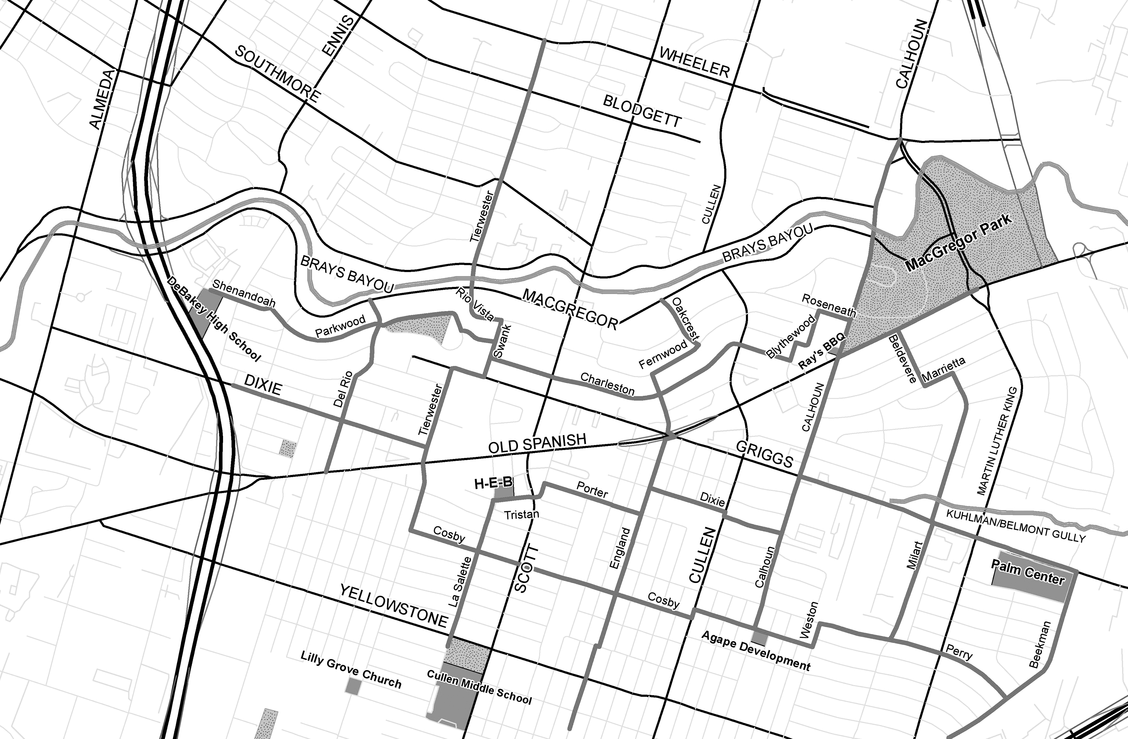
SEHTA Proposed Greenway Map. (With the exception of Brays Bayou, dark gray lines indicate proposed route. Black (highways), and light gray (local streets) indicate routes unaffected by proposed plan.) SEHTA, Southeast Houston Transformation Alliance.
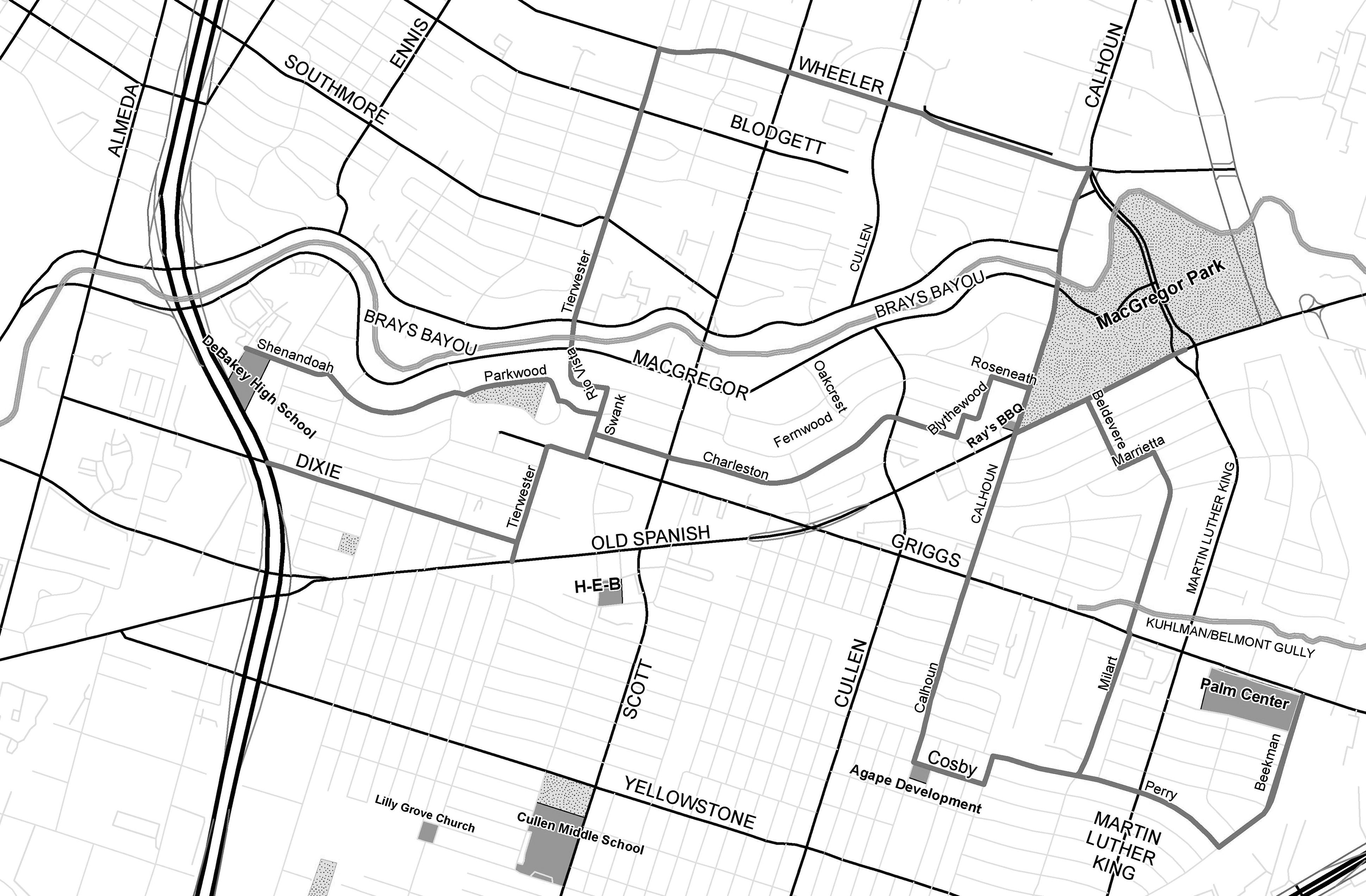
Houston Southeast Proposed Greenway Map. (With the exception of Brays Bayou, dark gray lines indicate proposed route. Black (highways) and light gray (local streets) indicate routes unaffected by proposed plan.)
Despite the history of inequality and economic downturn, the greenways initiative in OST/SU is the latest in a series of decisions by public and private entities that have shaped economic development and livability in the area. If executed effectively and equitably, the installation of greenways in OST/SU could increase quality of life for neighborhood residents by improving walkability to a level found in other urban Houston neighborhoods. In opposition to a history of inequitable services and disinvestment, greenways represent an investment in health, living standards, and economic opportunity for OST/SU's mostly black and, increasingly, Hispanic residents. The construction of mobility infrastructure on par with that of wealthier and whiter communities is a promising first step toward rectifying the area's historical environmental injustices.
While Southeast Houston is largely poorer and less white than other areas in Houston's inner loop, there are significant differences in power and privilege across neighborhoods within the region. Residents of Riverside Terrace, the neighborhood just north of OST/SU and south of Brays Bayou (Fig. 1), are wealthier and better educated than OST/SU residents. The median income there is roughly $10,000 greater than that of OST/SU, 16 and residents already have easy access to the Brays Bayou bikeway. Taking these power differentials as well as current gaps in access to neighborhood amenities into account, the placement and implementation of greenways must be carefully planned to contribute to a just distribution of neighborhood amenities in OST/SU relative to other nearby communities.
Methodology
Data
A team of four Rice University undergraduate researchers, working on behalf of SEHTA, under the advisement of faculty members and a graduate student, conducted a survey of proposed greenway usage and self-rated health in the OST/SU neighborhood. The survey comprised a convenience sample of 157 OST/SU residents and stakeholders who were recruited throughout the OST/SU neighborhood, and incorporated the two proposed greenway maps (SEHTA and Houston Southeast, Figs. 1 and 2), which were randomly assigned to survey respondents. The two proposed greenway maps largely overlap in the northern half of the neighborhood, but differ dramatically in the southern half of the neighborhood. Respondents were not told which proposed greenway they were viewing to minimize any potential bias against SEHTA or Houston Southeast. To ensure greater reliability, the sample was drawn from eight different locations throughout the OST/SU neighborhood, including a major bus terminal and a local washateria (laundromat). In addition, to avoid excluding potential Spanish-speaking respondents, the survey team included two Spanish-speaking undergraduates, who translated the survey into Spanish. However, because the sample is not random, it is not necessarily representative of the OST/SU neighborhood and thus we limit our discussion of findings to the sample. Nevertheless, the sample does resemble many neighborhood characteristics more broadly (e.g., 84% of survey respondents were black, while 78% of OST/SU residents are black; 71% of survey respondents were ages 18–64 years and 17% were 65 years or older, while 60% of OST/SU residents are ages 18–64 years and 15% are 65 years or older). Seven surveys were conducted in Spanish.
Measures
Our primary dependent variables are ordinal measures of projected frequency of greenway use and projected intensity of greenway use. To obtain these data, respondents were first presented with a graphic depicting either the SEHTA map or the Houston Southeast map and asked, “Would you use the greenway? If no, why not? If yes, how often?” Respondents were provided with five options for how often they would use the greenway; they were then asked “How long would you normally use the greenway?” and given four options to choose from. 17
We use seven independent variables to predict projected frequency and intensity of greenway use. Our primary independent variable is a binary dummy variable coding the randomly selected greenway map used during the survey: either Houston Southeast's proposed greenway map or SEHTA's proposed greenway map. Other independent variables include gender, race (coded as a binary variable measuring respondents' race as black or non-black), age, educational attainment (measured as an ordinal variable from “less than high school” to “college or higher”) access to vehicle, and a binary variable capturing (non-)residence in OST/SU. Table 1 presents summary descriptives of dependent and independent variables.
GED, General Educational Development; HS, high school; OST/SU, Old Spanish Trail/South Union; SD, standard deviation; SEHTA, Southeast Houston Transformation Alliance.
Analysis
Based on prior work arguing that linear regression models provide better model fit for ordinal dependent variables, 18 we use linear regression models to predict projected frequency and intensity of greenway use. [Note: In our analysis, we also used ordinal logistic regression models to predict our outcomes of interest. Because the linear regression model provided better fit and explained more of the variance in the data (Frequency: R-squared = 0.14; Intensity: R-squared = 0.096) than the ordinal logistic regression model (Frequency: Pseudo R-squared = 0.07; Intensity: Pseudo R-squared = 0.03), we base our analysis on linear regression results. However, the results in terms of important predictors of greenway use are similar across the two models. Ordinal logistic regression models are available upon request.]
Discussion
Overall our results point to a single dominant factor for projected frequency and intensity of greenway use: the proposed greenway map. The map respondents were shown was a significant predictor of both frequency and intensity. Table 2 shows that respondents who were randomly shown the SEHTA map were statistically more likely to report higher projected frequency and intensity of greenway use than respondents who were shown the Houston Southeast map, all else constant.
Note: **p < 0.01; *p < 0.05; †p < 0.1.
More surprising, however, is that residency status in the neighborhood is only a weak statistical predictor of projected frequency of greenway use, both in terms of the coefficient and p-value, and is insignificant in predicting projected intensity of greenway use. Why is residency in the neighborhood not a strong predictor of both frequency and intensity of greenway use, all else equal? To help explain this result, we turn to a related characteristic of respondents' residential contexts: current neighborhood walkability. We include current neighborhood walkability scores in our second set of models because we reason that respondents' current or past experiences with walkability in their residential context may shape their perceptions of future greenway use in OST/SU. Using
Results from our second set of models visualized in Table 3 again indicate that the map respondents viewed is a significant predictor of frequency of greenway use. Also, in terms of projected intensity of greenway use, respondents currently living in ZIP codes with higher walk scores are more likely to report greater intensity of greenway use than those living in less walkable ZIP codes, all else equal. These findings suggest that respondents' current residential context shapes perceptions of the intensity with which a proposed greenway would be used, net of other important factors. These results help explain why current OST/SU residents are not much more likely to use the proposed greenways than nonresidents: because their current and past experiences with neighborhood walkability do not provide contextual clues for how they might experience future neighborhood walkability.
Note: **p < 0.01; *p < 0.05.
Conclusions
Our findings indicate that respondents would be more likely to use a greenway based on the map provided by SEHTA with greater frequency and degrees of intensity. These findings in one sense are not surprising—the SEHTA map is more comprehensive and is oriented toward the southern half of the neighborhood, while the Houston Southeast map is oriented toward the northern half of the neighborhood. However, it is important to demonstrate higher levels of projected use empirically to be able to provide an evidence-based recommendation on greenway plan implementation to the City of Houston, Houston Southeast, and other governing bodies involved in allocating funding for such infrastructural investments.
Our findings also suggest that residential context shapes perceptions of intensity of use. Nonresidents—those who come to OST/SU for work or to visit family, for example—may live in areas with high levels of walkability and already experience the benefits of living near protected walking spaces. Thus, they are more likely to report greater intensity of greenway use in OST/SU than current residents or other nonresidents in areas with low walkability. This finding provides evidence for the sociohistorical roots of environmental injustice in neighborhood amenity planning and underscores the need to pursue community-oriented neighborhood amenity implementation. Our findings indicate that implementing the SEHTA-proposed greenway map and plan—the single most important predictor of frequency and intensity of use—would aid future increases in perceptions of intensity of greenway use due to the potential feedback between current neighborhood walkability and perceived intensity of use. Implementing a greenway plan with heightened levels of community support, such as that proposed by SEHTA, also has potential positive implications for resident health and well-being.
At a broader level, our work contributes to conversations about how to integrate social scientific methods within an environmental justice framework to facilitate the formation of equitable policies. Our research suggests that examining perceptions of policy while it is being developed—paying particular attention to those who have historically been excluded from policy making—can promote inclusive community-building practices. In other words, in addition to tracing the harmful effects of past policy over time, what can be learned from community stakeholders about what they want for the future and how can community input shape the policies that are put into play?
While our findings are limited to a sample of OST/SU residents and not generalizable to the broader neighborhood, they do offer important insights into the nature of infrastructural interventions, how communities perceive these interventions, and what may be shaping their perceptions.
Footnotes
Author Disclosure Statement
No competing financial interests exist.