
Abstract
Abstract
In 1987, and again 20 years later, the United Church of Christ (UCC) presented research showing that 60% of African Americans lived near an unregulated toxic waste facility. We build off the original UCC study and present an analysis of minority populations in relation to superfund sites, using the geometric complexity of congressional districts (CDs) as a proxy for gerrymandering within the lower 48 states. We further the analysis by looking at different areal aggregations and find that regardless of the aggregation there is a relationship between race and distance from superfund sites. Moreover, we address the issues of inherent complexity as it relates to coastal areas, which could bias the analysis, by systematically reducing the complexity within a geographic information system (GIS). At the CD level, there is a statistically significant relationship where race becomes “whiter” and less “African American” as the Euclidean distance increases from superfund sites. While there is a strong relationship between the gerrymander coefficient and the proximity to superfund sites (R2 = 0.58, DF = 347, p < 0.001), variables such as median income, air quality, and unemployment may account for the unexplained variance in the model. We also found a strong relationship between the percent white and a higher gerrymandering coefficient, indicating that minority populations are effectively “gerrymandered out” of the white and lower environmental hazard districts. This research is novel in that it suggests a calculated effort to marginalize minority populations and warrants further investigation while analyzing additional proxies for environmental hazards.
Introduction
M
A growing body of literature supports the claims that racial minorities are subject to environmental hazards more than nonminorities. In particular, environmental justice (EJ) gained attention after the United Church of Christ (UCC) published a study in 1987 following a controversy over the placement of a polychlorinated biphenyl (PCB) landfill in a minority community in Warren County, North Carolina. The study showed nationally that 60% of African Americans lived near an unregulated toxic waste site. 4 Since the UCC study, similar issues have met with grassroots activism and academic research, with growing evidence that environmental pollution is disproportionately located in low-income, minority communities. 5 When the UCC revisited the study 20 years later, the disparities between racial groups and proximity to environmental pollution had magnified. 6
Race is an independent predictor in the location of hazardous waste sites, and when social class variables such as income, education, and occupational status are held constant, people of color face increased toxic exposure levels. 7 Numerous case studies confirm these findings, among which is the recent water crisis in Flint, MI. Although race alone can predict toxic exposure levels, it is useful to study environmental inequalities using class, status, and power as additional indicators. 8 Wealthier communities have the money, education, and political power to prevent the close proximity placement of hazardous waste facilities, while disadvantaged and impoverished areas lack such resources. 9 German theorist Ulrich Beck observed that the distribution of risk adheres to the class pattern, with wealth gathering at the top levels of the socioeconomic ladder and risks accumulating at the bottom. 10
Exposure to environmental hazards is one explanation for health disparities that exist among low-income and minority populations. 11 African Americans, as well as other minorities, exhibit a greater frequency of health issues corresponding to environmental toxin exposure. 12 Minority and low-income populations are more susceptible to such environmental insults due to restricted accessibility to adequate healthcare and the increased vulnerability to malnutrition. 13 Superfund sites present underrepresented populations with yet another health threat. For example, a recent study shows an association between proximity to superfund site and the cumulative incidences of non-Hodgkin lymphoma. 14 Moreover, current legislation aimed at reducing environmental insults is on a system that benefits all equally while failing to recognize the increased vulnerability of specific populations. 15 Although there has been investigation aimed at developing effective ways to determine high-risk areas, more work is needed. 16
Spatial segregation of African Americans into high-poverty neighborhoods is directly related to poor health. 17 Following the 1960s, African American young adults who had graduated high school or attended college entered increasingly more integrated neighborhoods. 18 African Americans of higher socioeconomic status are less segregated, with middle-class individuals living among a higher percentage of white neighbors. 19 Yet, this decline in segregation is limited. Middle-class African Americans often live amidst whites who are less affluent, and their neighborhoods are not the equivalent of whites with a similar socioeconomic status. 20 Currently, more than a quarter of the African American population still resides in the highest poverty neighborhoods, making them more vulnerable to environmental harm. 21
The forces behind such actions of environmental injustice are complex and can be seen as racism. While some consider market forces neutral and nonracist based on the premise of consumer sovereignty, neoliberal reforms that agree with this ideology tend to make inherently racist decisions. 22 Moreover, these actions are systemic, arising from long histories of colonialism and white supremacy. 23 Viewing issues of EJ from the perspective of white privilege suggests that whites do not always purposely place these facilities near people of color. 24 In other words, these are not single racist acts with malicious intent, but a result of the “naturalized decisions of millions of whites in a racialized society.” 25 Instances of indirect discrimination exist in the placement of superfund sites in Florida. 26 Moreover, a study of Los Angeles showed that disproportionate siting played a greater role on resulting environmental circumstances than minorities moving to the area demonstrating that these sites are placed, with some intention at least, away from white communities.
Gerrymandering is yet another way that spatial inequalities manifest themselves. Through gerrymandering, the political system can perpetuate racial inequalities by depriving specific populations of political power. 27 Although the intent of the Voting Rights Act of 1965 was to equalize political power by preventing large disparities in populations between districts, redistricting is manipulated to achieve political goals or to deprive jurisdictions of political power. 28 The same process applies to race in what is referred to as racial gerrymandering. The result is complex voting districts that draw together people from different socioeconomic and cultural backgrounds. 29 Racial gerrymandering ensures that the safest schools go to predominantly white populations, 30 and it is not unreasonable to assume that the same process would occur with the placement of environmental hazards. Racial gerrymandering is an “expressive harm aimed at preventing jurisdictions from sending an impermissible message by separating voters on the basis of race without adequate justification.” 31
Through the 1980s, the courts primary criterion for determining redistricting was equality of total population while ignoring spatial context. Young conducted some of the earliest work to quantify the spatial compactness of voting districts. 32 Niemi et al. expanded on this and analyzed 25 ways to quantify spatial compactness. 33 Assisted by geographic information systems (GIS), studies that attempt to estimate gerrymandering do so by quantifying the shape complexity. 34 Immutable boundaries, for example, a coastal boundary or where a river defines a boundary, will contribute to shape complexity of voting districts that share a naturally complex border, and must be addressed. A proposed solution is to calculate out the proportion of the perimeter that is mutable versus immutable. 35
Although several bills to create EJ laws were introduced in the past decade, a gridlock has prevented them from being successful. 36 Finally, due to the spatial analytical capabilities of GIS, they are an invaluable tool to address EJ. In this analysis, we answer the following questions as they relate to EJ.
• How does the relationship of race (percentage white/African American) and the exposure to environmental pollution manifest itself at different spatial scales of areal aggregation?
• Is there a relationship between the extent to which congressional districts (CDs) are gerrymandered and the exposure to environmental pollution (using the distance to superfund sites as a proxy)?
• What is the relationship between the extent to which a CD is gerrymandered, and the relative percentage of white versus African American?
Methods
Scale and data
We utilized demographic and spatial data sourced from the United States Census Bureau (USCB) and analyzed the lower 48 of the United States, aggregated at the CD, and zip code level to address our three main research questions. The demographic census data consisted of Topologically Integrated Geographic Encoding and Referencing (TIGER) shape files, with the standard Summary File 1 (SF1) census data associated. 37 Beginning in 2000, the U.S. census allowed respondents to choose more than one race, creating 63 multirace possibilities (126 including Hispanic and non-Hispanic as a factor). Here we chose to focus only on those reporting single race white and single race African American.
Proxies
To consider exposure to environmental hazards, we used the EPA superfund data as designated under the Comprehensive Environmental Response, Compensation, and Liability Act (CERCLA) of 1980. Whereas there is no single measurement of EJ, many studies have used the proximity of minority populations to superfund sites as a proxy. 38 Common methods of analysis include either proximity to or whether a zip code/district hosted a waste site. The landmark UCC study used host versus nonhost and the amount of waste produced on-site to measure injustice. Here we applied the ArcGIS 10.3 Spatial Analyst (ESRI, 2013) extension to calculate the Euclidean distance from superfund sites as a measure of EJ (Fig. 1). To analyze the relationship between superfund site location and zip code tabulation areas, we used the ArcGIS 10.3 Zonal Statistics tool to calculate the average distance from the superfund site to the zip code tabulation area (Fig. 2). We also calculated the mean Euclidean distance from superfund sites to the CDs (Fig. 3).
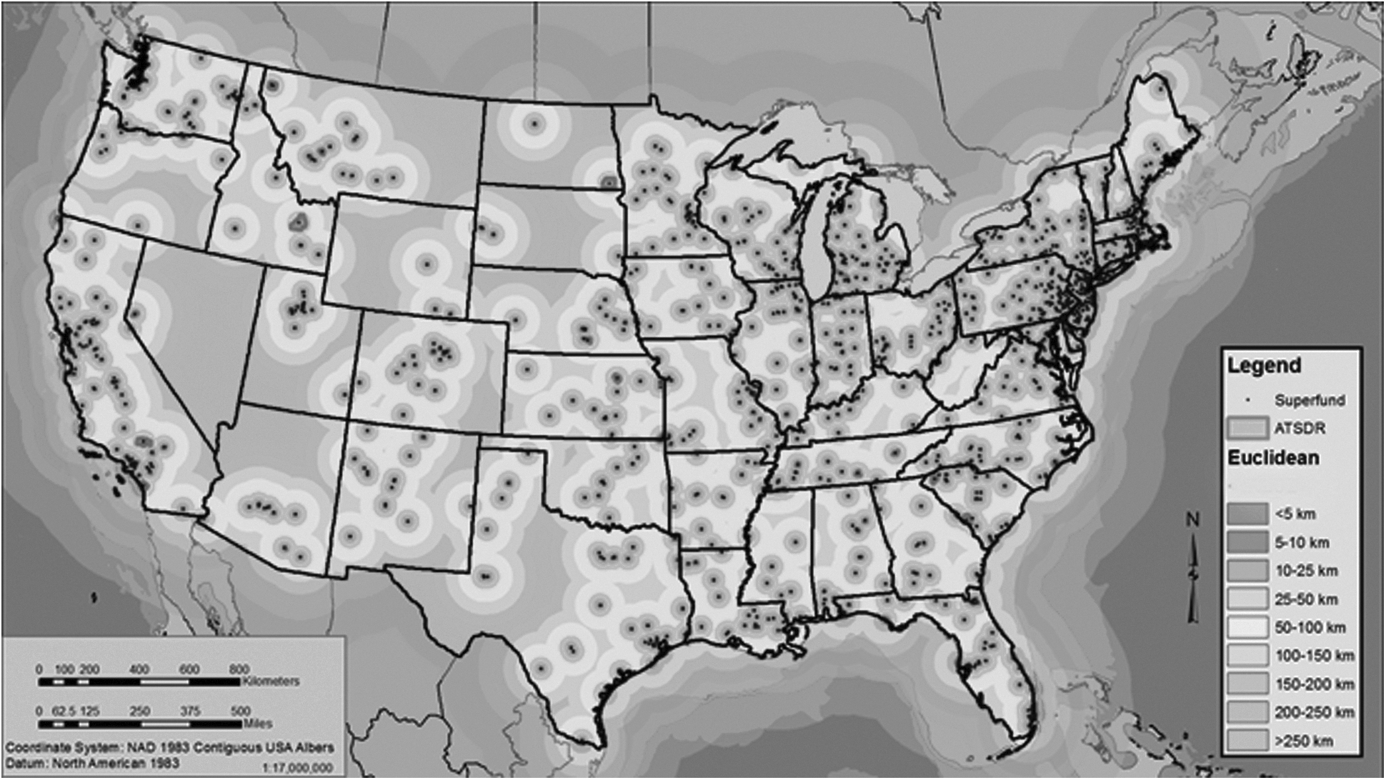
Superfund sites located within the conterminous United States, and the Euclidean distance raster calculated from the superfund site locations.
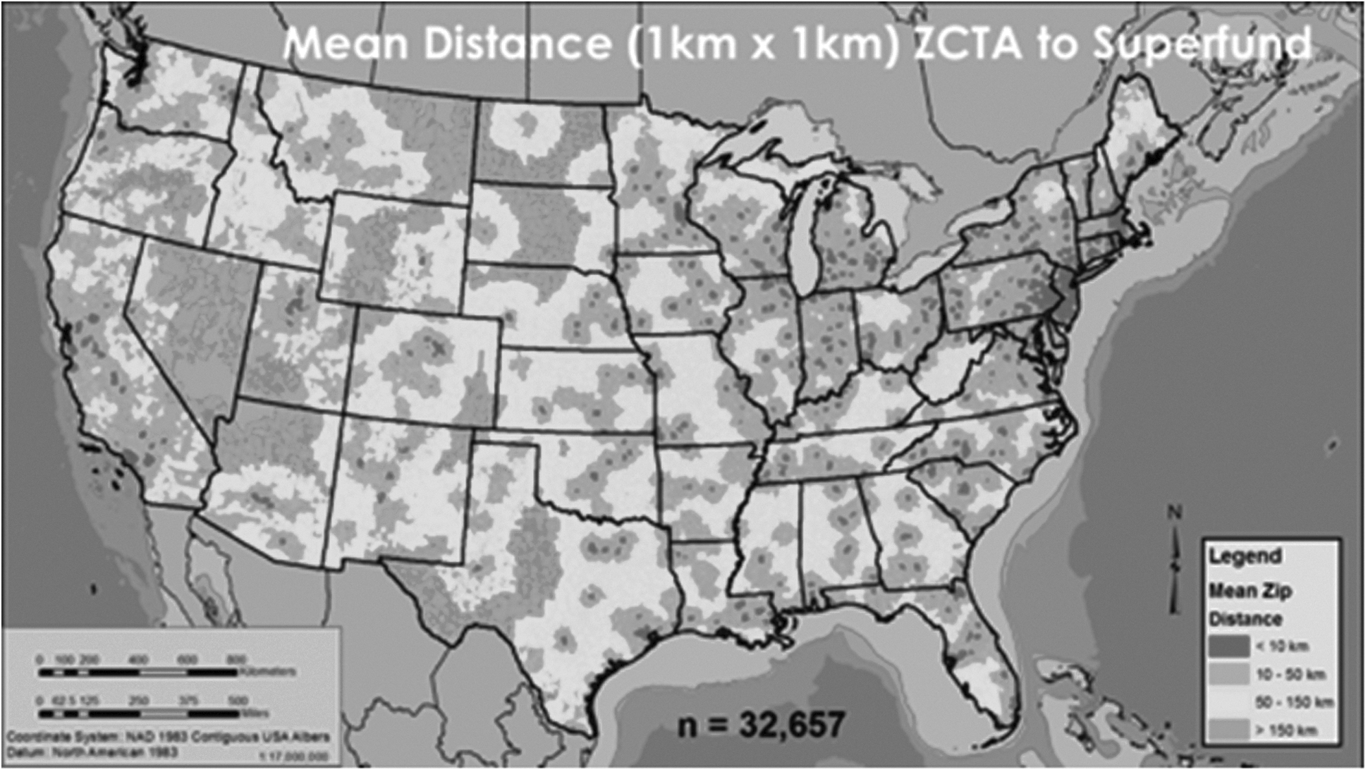
Data at zip code tabulation areas classified into four bins as a function of distance from superfund site location.
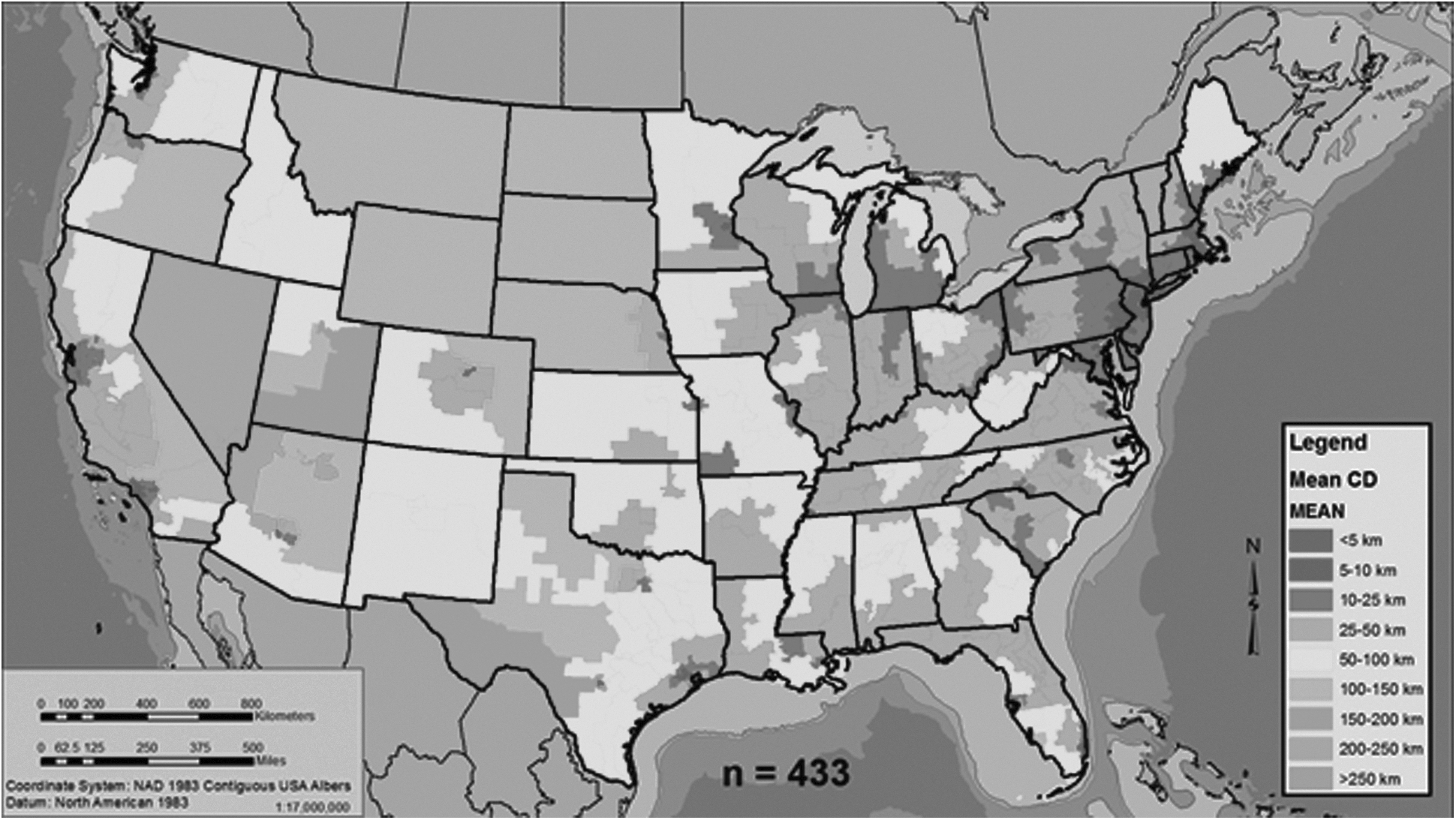
Mean distance of congressional districts from the superfund site locations.
Building on the work of DeSante and Sparks, 39 we estimated an index of Gerrymandering (G) using ESRI's ArcGIS 10.3. The initial analysis considered the entire perimeter (no immutable boundaries) where G = p2/a (Fig. 4). To address the complexity associated with immutable boundaries (e.g., shorelines), we systematically simplified those boundaries using the ArcGIS 10.3 Simplify tool to systematically remove vertices, and thus reduce the geometric complexity. Finally, we analyzed the relationship between the percentage white and the percentage African American of each CD in relationship to the calculated G. All statistical analyses conducted for this work were completed in R 3.3.1. 40
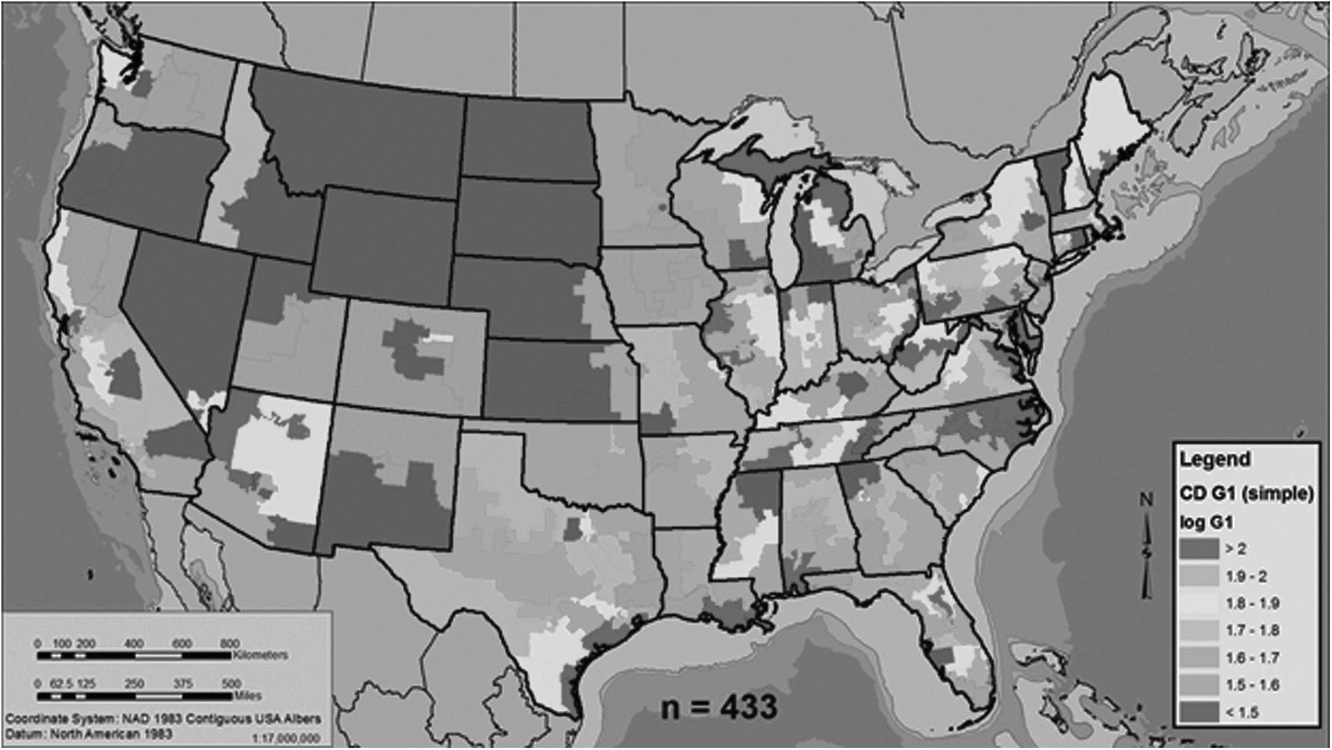
The mean log of the gerrymandering coefficient (G) per congressional district.
Results
At the zip code aggregation, we bifurcated the data into four categories based on distance. Due to the lack of normality, we used the Kruskal–Wallis ranked sum H (p < 0.001), and when plotted the trend is clearly visible with race getting both whiter and less African American as the distance increases (Fig. 5). At the CD level, we see an almost identical pattern to that of the zip code tabulation areas, where the population becomes whiter and less African American the further that you move from the superfund site (Fig. 6). While it was interesting to see a relationship of race to distance, the fact that it is visibly apparent regardless of areal aggregation (zipcode vs. CD) is telling.
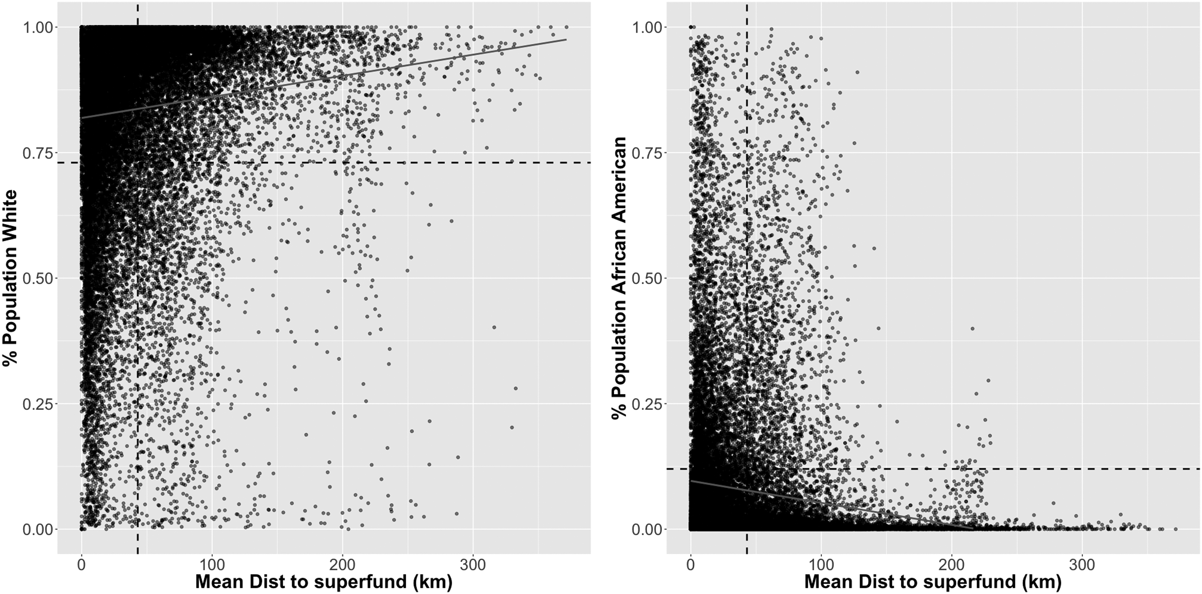
Mean distance from superfund site location to zipcode tabulation areas in relation to the percent population white (Left) or black (Right). There is a clear trend with the percent white increasing as distance from superfund site to the zipcode tabulation areas increases, and the percent black increasing while the distance from the superfund site to zipcode tabulation area decreases.
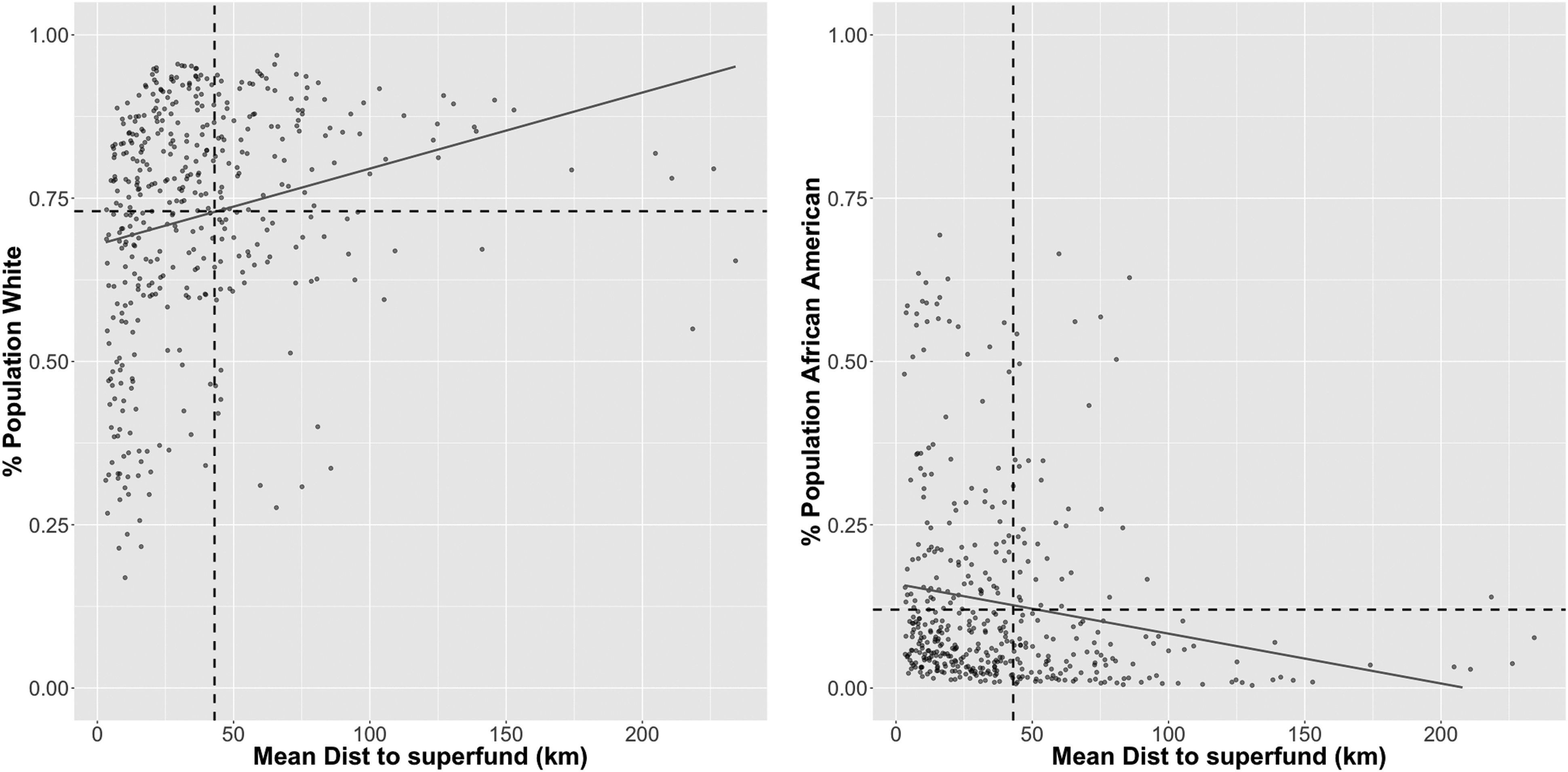
Mean distance from superfund site to the congressional districts in relation to the percent population white (Left) or African American (Right). There is a clear trend with the percent white increasing as distance from superfund site increases, and the percent black increasing while the distance to superfund site decreases.
At the CD unit of analysis, results indicate that there is a positive and significant relationship between the log of the calculated Gerrymandering Index (G) and log of the mean distance to a superfund site (R2 = 0.58, DF = 347, p < 0.001) (Fig. 7), indicating that as distance increases, so does the extent to which a district is gerrymandered. Analysis of the output (Table 1) and the residual distribution (Fig. 8) associated with the models indicates a good fit. Specifically, the residuals indicate a predominantly random pattern around 0 and the coefficient estimates are significant at p = 0.05. Moreover, the small variation among the R2, multiple R2, and the adjusted R2 further indicates a good model fit. This suggests that a successfully gerrymandered district has the effect of providing incentive to the elected official to make his/her district exclude or at least keep siting of potential environmental hazards at a distance from constituents of a racial group that may serve as the respective political base. Results from the analysis that addressed the percentage of white/African American versus the calculated G indicate that, as the CD became more complex geometrically (e.g., the gerrymander coefficient increased, the percentage white also increased. These results are strikingly similar to those shown in Figure 6. Conversely, we found that as the geometric complexity of the CDs decreased and the distance from superfund sites decreased, the percentage of African American population increased. These results suggest that current gerrymandering practices effectively marginalize the African American population (Fig. 9).
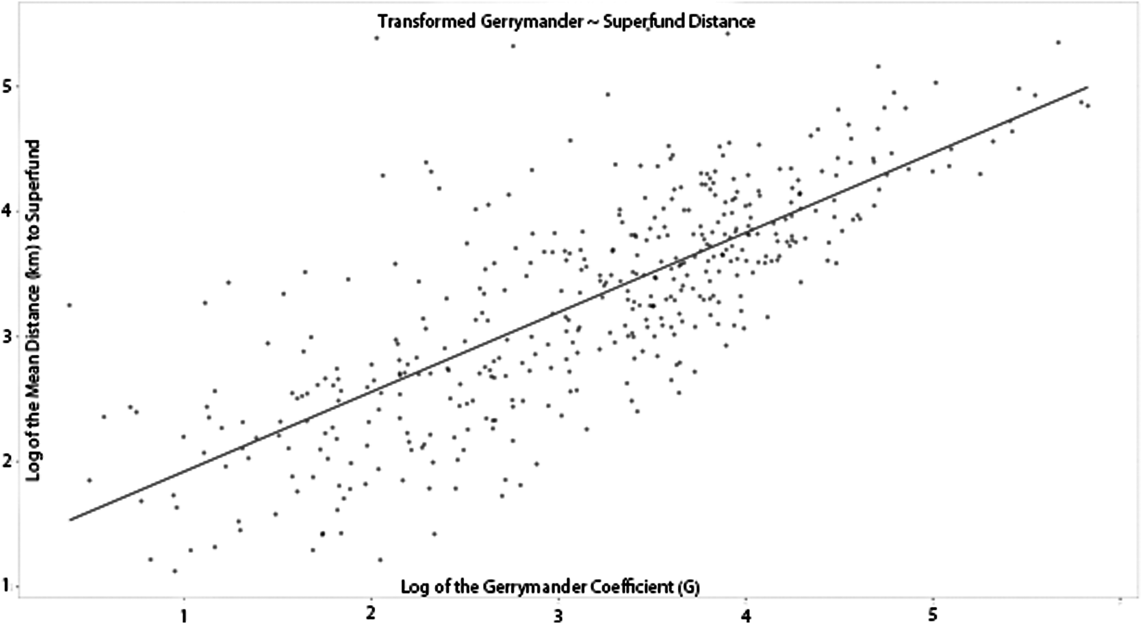
Representation of the linear relationship between the log G and the log of the distance to superfund site. The variables were log-transformed to meet normality requirements of linear regression. These results indicate a strong positive relationship between the distance from a superfund site and the extent to which a congressional district has been gerrymandered.
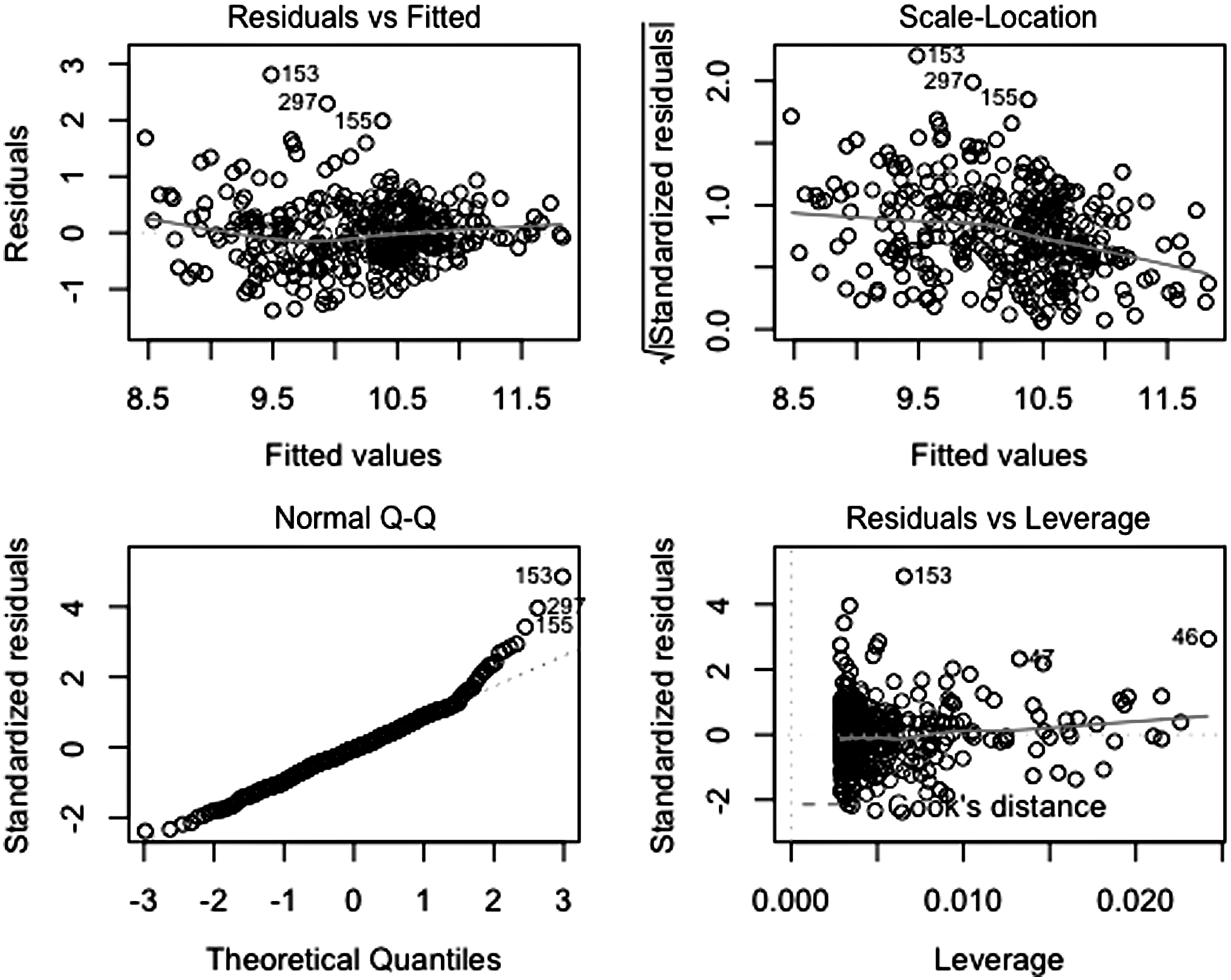
Residual plots from the superfund versus Gerrymander regression model indicating a good model fit. Residuals are randomly distributed around 0.
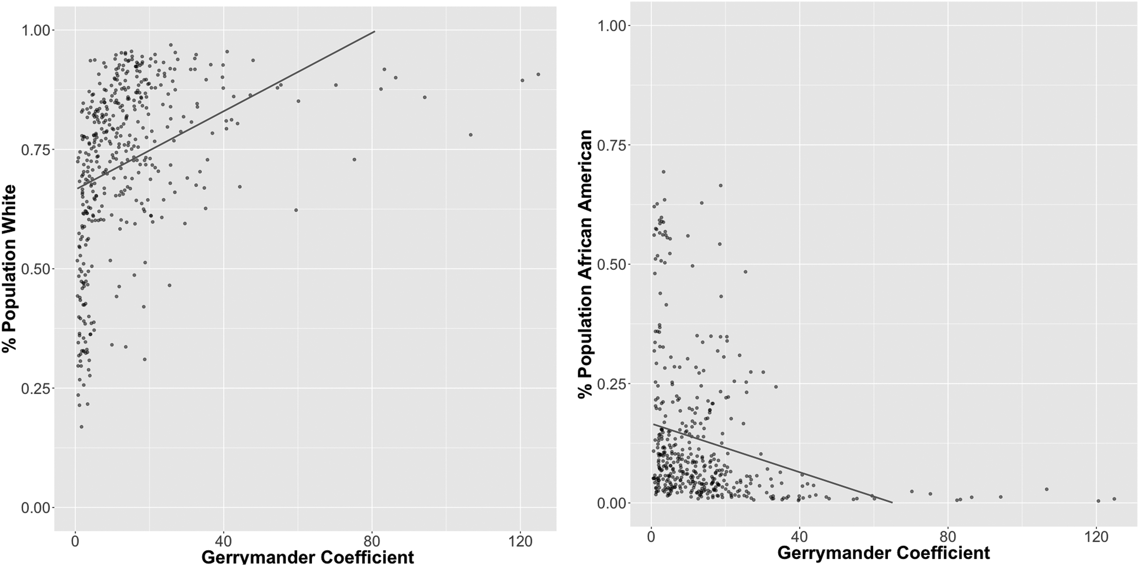
Relationship between the calculated gerrymandering coefficient (G) and the percent of population that identifies as either white or African American. The pattern is similar to the analysis that looked at the percent of population white or African American versus distance to superfund.
The similarities among the R2, multiple R2, and the adjusted R2 indicate a good model fit, as well as the Pr(>|t|) values.
After addressing the inherent complexity of immutable boundaries, we found the models to still be adequate in their predictive capabilities (Mutable [Interior]: R2 = 0.60, Immutable [Exterior]: R2 = 0.47) (Fig. 10). While we do find that the immutable boundaries, even after simplification, exhibit a lower R2 value than the mutable boundaries or the initial model, the results are still significant. These findings indicate that even with the inherent complexity that exists in many of the immutable boundaries, the original models adequately represent the issue surrounding gerrymandering in the context of this research.
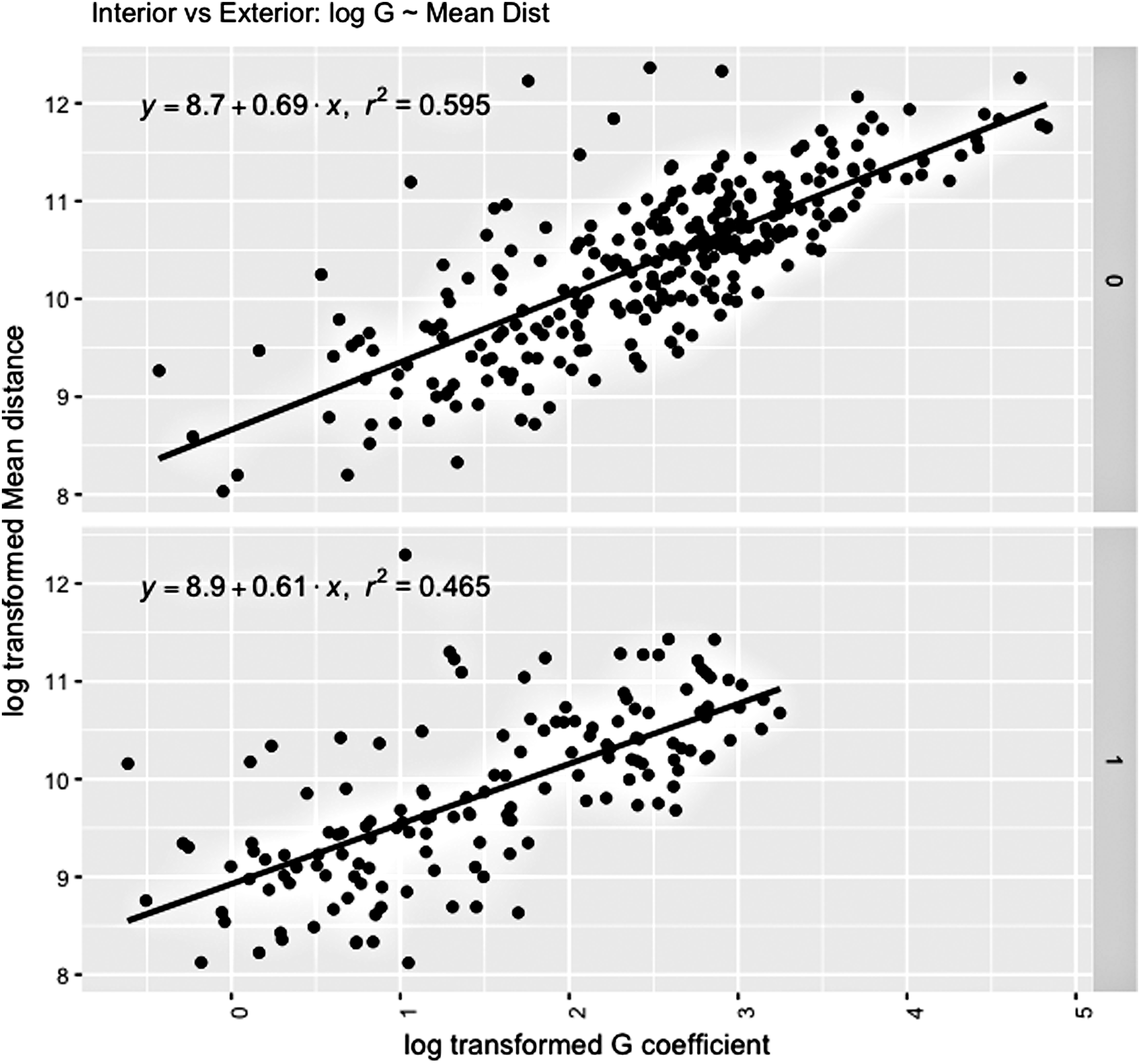
Distance to superfund sites of Interior (Mutable) versus Exterior (Immutable) boundaries in relationship to the log G, after simplification of the Immutable boundaries.
Discussion
This analysis provides a simple, yet telling investigation into the percentage of the population that reported as single race (white and African American) as a response variable to the predictor of distance to superfund site. We show that the closer you are to a superfund site the more likely you will find African American families. Moreover, the results found in this study support current research indicating that minority populations are at a significantly greater risk of environmental health issues. 41
The extent to which CDs are gerrymandered and exposure to environmental pollution was also telling. The more a district is gerrymandered, the less exposure to environmental pollution. To understand the true weight of this finding, it should be combined with the last question we answered that the more gerrymandering in a district, the less African Americans in that district. The racial power of gerrymandering has been demonstrated by Soffen 42 and Hasen, 43 and more evidence is presented here in clear, spatial terms. The larger question of how discrimination works is partially answered by the findings about gerrymandering. There is a clear intent on change to favor white racial groups over African American racial groups. This spatial analysis could be used to help restrict gerrymandering, and therefore racially motivated redistricting, based on a not-to-exceed threshold G coefficient.
These research findings also bring up the question of how. Soffen and Hasen demonstrate a structural aspect to gerrymandering resulting in more power to white Americans. The how is through a structural and intentional process. We answer part of the question how by demonstrating the spatial impact of gerrymandering. Stretesky and Hogan 44 discuss direct and indirect processes of discrimination related to their study of superfund sites in Florida. Gerrymandering is a direct form but does not account for all the aspects of discrimination meaning that other indirect yet structured processes of discrimination are involved such as the lack of choices by some populations due to overall societal discrimination. This is a serious issue that policy makers should consider when looking for solutions to EJ.
Although this research focuses on race and environmental pollution, future research could account for within-group variances on a spatial level. How do social class, gender, age, and education within groups tell us more about who is impacted? For example, we know that African Americans are more likely to experience poverty, especially African American children. 45 African American and Hispanic American children are more likely to experience lead poisoning. 46 Likewise, some EJ researchers are discussing the importance of intersectionality in understanding how the disparities in environmental hazards are experienced. 47 , 48 Intersectionality theorists have determined that there are intersecting aspects of oppression such as race, class, gender, and age. 49 This deeper analysis of how might lead to understanding the ways that different people experience environmental hazards, which could lead to solutions that are more fruitful. Likewise, a more robust statistical analysis, including geographically weighted PCA and/or geographically weighted regression, may offer insight beyond this research.
The examination of the relationship of superfund to the gerrymander is novel and should be of interest to researchers who study issues of social or EJ, as well as policy makers. The fact that there are significant changes in the racial makeup of an area as a function of distance to a superfund site is not surprising. However, we do believe that because the relationship is consistent across all scales of spatial aggregation, we suggest further investigation. Moreover, the relationships identified between the geometric complexity of CDs as measured by G and the relative percentage of white versus African American presents a telling story of how current practices are marginalizing the minority populations. This research has been an exploration into EJ using public data from the U.S. census and EPA to retell a familiar story in a novel way: minority populations are systematically exposed to a larger amount of environmental hazards than white populations. Most importantly, this research presents unique findings concerning EJ, indicating that increased gerrymandering serves to exclude minority populations from CDs with less environmental hazards.
Footnotes
Author Disclosure Statement
No competing financial interests exist.