




Abstract
Abstract
The transformations brought about by climate change and the continued growth of cities are having an impact on urban climate. In urban spaces, especially in public spaces, environmental conditions are becoming more uncomfortable and this is affecting the health and quality of life of city dwellers. This study of climate quality in the city of Chillán revealed that there are insufficient public spaces to provide acceptable environmental quality for the entire population. It also showed that high-income areas, located in the peri-urban zones of the city, enjoy a better climate, environment, and air quality. This article analyzes urban climate injustice, as evidenced by the sharp socioeconomic differences in the quality of environment to which urban residents are exposed, and highlights the need for public spaces to improve the environmental quality for residents.
Introduction
The twenty-first century is proving to be a turning point in both global urbanization processes and awareness and concern about the consequences of climate change. These two issues are central to the issue of the environmental quality of urban spaces. In urban spaces, particularly urban public spaces, we can observe differences in environmental conditions that have an impact on the quality of urban life.
In Latin America and the Caribbean, 79.5% of the population lives in cities 1 and a large proportion of this number lives in medium-sized cities. Many of these cities share the chaos, spreading, privatization, fragmentation, informality, conflict, exclusion, and pollution that characterize a metropolis 2 . In Latin American cities, including Chilean cities, there are clear socioenvironmental inequalities, as is common in all underdeveloped countries. These inequalities are particularly marked in medium-sized cities, as they have less information and fewer resources than large metropolises such as Santiago, the capital of Chile; they have not been as extensively researched and do not receive as much public investment. 3 , 4
Medium-sized cities are the site of certain processes and perform functions that can help to improve living conditions and increase economic opportunities. At the same time, however, these cities—like large metropolitan areas—are experiencing physical segregation and social marginalization and it is these processes that determine where the impact of climate change will be most severe. These are highly vulnerable to natural hazards, which not only affect the sustainability of human habitats but also increase the vulnerability of the population. 5 A clear example of this is the exposure of the population to extreme temperatures and the effects of this on thermal comfort and health.
This research explores the issues of climate justice and climate quality in the medium-sized city of Chillán, Chile. 6 We analyzed users' perception of the environmental quality of public spaces in the city using criteria defined by experts and key local figure actors. We also consider the difficulties and obstacles faced by urban planners as they attempt to address the challenges of urban sustainability and climate justice at a local scale level.
This was a mixed methods study. The qualitative methods include consultation with experts and key actors on climate quality, surveys of the thermal comfort of users of selected public spaces, photographic records of the use of public space, and a review of urban planning tools. We also used a quantitative method to define an index of climate quality based on vegetation, soil sealing, air temperature, and other urban and environmental variables. Spatial data on climate quality were correlated with the Adimark categories of socioeconomic status (SES), which divides populations into five groups—in descending order of income they are ABC1, C2, C3, D, and E7—to evaluate climate justice. We used SES as a proxy for variables that are associated with it, specifically building density, soil sealing, and vegetation, which, in turn, determine climate quality.
Background
Environmental and climate justice
The term environmental justice was originally used to refer to the uneven distribution of environmental disadvantages and benefits, which disadvantages lower income communities, ethnic minorities, and women. 8 Schlosberg and Collins 9 highlighted that use of the concept of environmental justice has expanded both horizontally and vertically. There has been a horizontal expansion as the use of the concept has spread beyond the boundaries of the country where it originated (the United States, at the end of the 1970s) and a vertical expansion in the sense that it has spread to different social contexts (communities, institutions etc.), where it has been incorporated into discourse. There is also a conceptual amplification in the fact that new concepts relating to environmental justice have created, such as climate justice. Thus we are experiencing the emergence of a new field of study that transcends interdisciplinary approaches.
The concept of climate justice emerged in relation to debate about global climate change, and it is considered mainly for evaluation of the distribution of its consequences. 10 Debate has focused on issues such as the identity of the countries that are or were historically the biggest emitters of greenhouse gases, which countries have benefited most from industrialization, and how this compares with the countries that have suffered most from climate change, which affects, for example, their ways of life and their quality of life.
The global discussion has largely taken place at nation-state level, but climate injustice can be addressed at multiple levels, such as the national and the local. 11 Despite the importance of these issues, both climate justice and the effects of climate change have hardly been considered in urban studies. The city is a privileged place to rethink issues of climate justice, 12 in terms of the concept of climate quality.
Toward urban climate quality
The study of climate justice in cities can include analysis of differences in the quality of the environment experienced by citizens. Ensuring a good climate in a city requires consideration of various factors at multiple levels of planning. 13 To ensure a high-quality environment, and in particular to ensure high-quality climate, a city must not only manage environmental problems, such as air pollution, and the reduction of emission sources, but it must also ensure adequate ventilation of the city, shade during summer, and access to sunlight during winter. Barcelona city council shows significant progress with its Plan de Ecología Urbana [Urban Ecology Plan], which specified a minimum number of hours of sunlight to which every residence is entitled, 14 among other standards.
Climate quality is not homogenous across a city; it varies according to the interaction of local climate with geomorphological factors, urban structure, and urban planning criteria. 15 Hence some residents of a given city will experience a better climate than others. This is not irrelevant in the context of climate change; homes in urban areas with low-quality climate—where factors affecting climate have not been taken account in the planning and design of the area—use more energy for air conditioning during the summer and heating during winter and more electricity for lighting. Furthermore, residents of these areas experience discomfort and inconvenience in open spaces, due to high temperatures, wind tunnel effects in streets, and unusual wind turbulence produced by the distribution of poorly designed high-rise buildings. 16
At present, there is not much evidence of sensitivity to environmental conditions in city design and even less attention is paid to climate. Climate-conscious planning 17 and designing public open spaces so that they offer access to or protection from wind and sun are important elements in the process of creating the conditions in which the residents of cities can adapt to climate 18 and enjoy good quality of life. The extant literature indicates that the main paradigms on which urban planning instruments and esthetic-formal proposals are based have not been able to take account of the complexity of the factors determining urban climate. 19
Taking account of climate factors in urban planning and management poses a challenge, because of economic constraints, lack of knowledge, historical priorities, short-term thinking and the brevity of politicians' tenure, 20 lack of meteorological data or inadequate data, 21 conflicts of interest, and lack of political will. 22
Case Study: City of Chillán, Chile
Area of study
Chillán is the capital city of the region of Ñuble (formed in September 2017, before it became part of the Biobío region). The city is a conurbation consisting of the communities of Chillán and Chillán Viejo (Old Chillán) and has a population of 204,180. It is located at latitude 36° 36′ south, at an altitude of 124 m above mean sea level. It has a warm temperate climate with winter showers, Csb in the Köppen classification for Chile. 23 According to data from the meteorological station Bernardo O'Higgins, 5 km northwest of the city, the average annual temperature over the past four decades was 13.7°C and the average summer temperature was 19.4°C. Based on measurements of atmospheric temperature in the city, the annual average temperature in the city center is 15.5°C.
Chillán is a very dynamic city, a fact that is reflected in the average growth of its urban surface in the past two decades, from 1800 in 1993 to 3010 hectares in 2016. This represents an increase of 38%, above the average of 27% for Chilean metropolitan areas.
According to data from the Chilean National Socioeconomic Characterization Survey 2015 (CASEN), 16.3% of the community of Chillán and 9.9% of the community of Chillán Viejo were living in poverty. 24
Public spaces in the city of Chillán
Of the larger medium-sized cities in the country, Chillán has one of the lowest proportions of public green space at only 1.7 m 2 per capita, lower than the national average (4 m 2 per capita) and also lower than the average for urban areas (∼3.5 m 2 per capita). In total, including roads and pavements, public spaces represent 33.5% of the total surface of the city, 25 if roads and pavements are excluded, however, the city has 329 public spaces covering only 4.4% of the total surface. The most common public spaces are playgrounds, of which the city has a total of 155, covering only 1.2% of the urban surface.
Information about the intensity and frequency of use of public spaces in the city was collected from a survey carried out by city council officials from Chillán and Chillán Viejo. Based on this information, five public spaces were selected: Plaza de Armas of Chillán [main square of Chillán], Paseo Peatonal [Arauco walkway], Parque Estero Las Toscas [Estero Las Toscas Park], Parque Sarita Gajardo [Sarita Gajardo Park] and Parque Monumental Bernardo O'Higgins [Bernardo O'Higgins Monument Park] (Fig. 1).
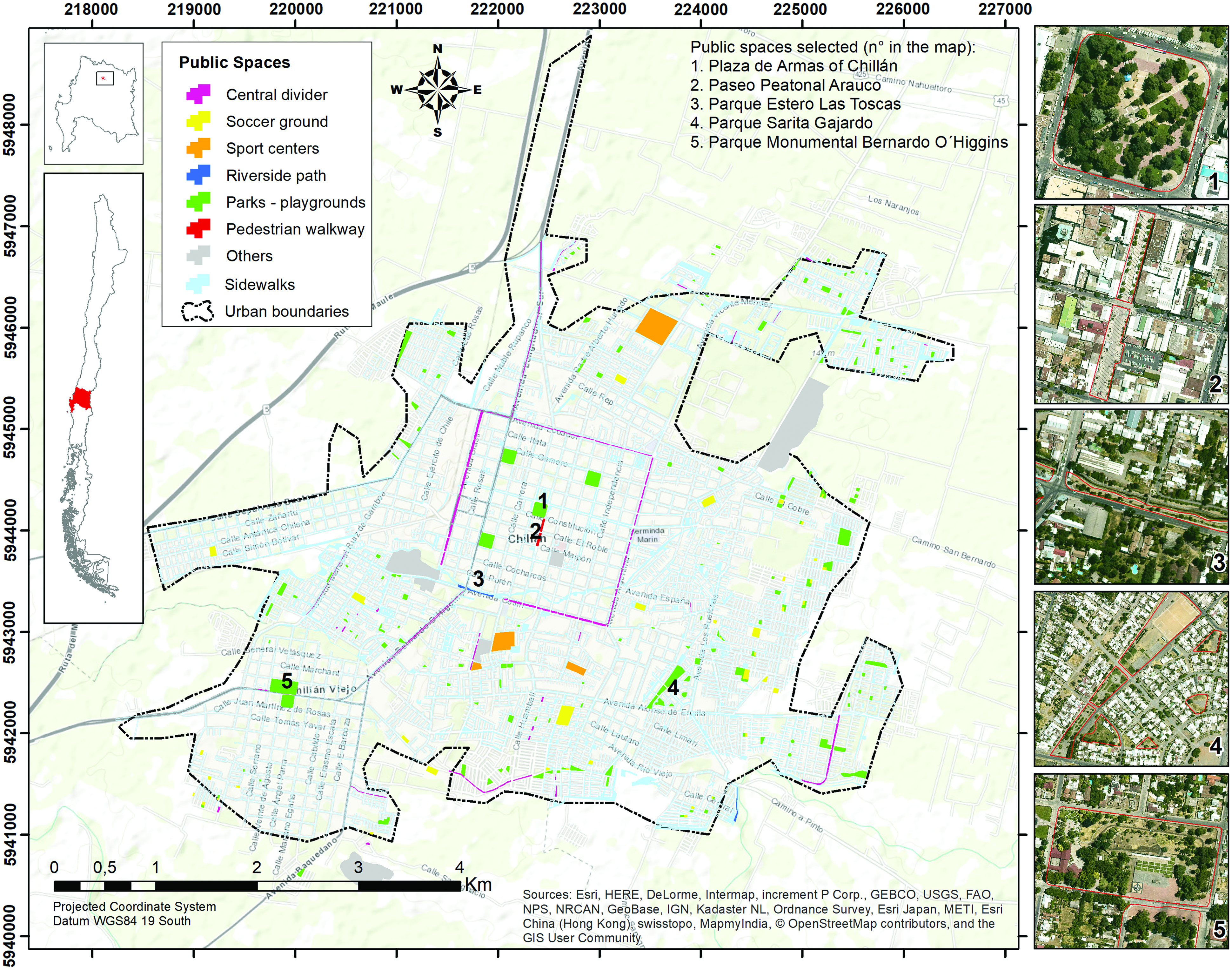
City of Chillán and the selected public spaces. Color images are available online.
Most of the 329 public spaces in the city of Chillán are located in areas where the residents have intermediate SES, there are 116 (24.4 hectares) and 75 (15.1 hectares) public spaces in areas where the population is predominantly C3 and D, respectively. However, the average surface area of these spaces is smaller than that of public spaces closer to higher income (ABC1) areas (28 public spaces; 12 hectares in total) and C2 (54 public spaces; 24.2 hectares in total). The smallest public spaces are in the residential areas dominated by people of low SES (E), where there are only eight nearby public spaces, six of which are playgrounds with an average area of 0.1 hectares.
Sports fields, of which there are many (38; total area of 10.7 hectares), are mainly located in the C3 and D areas, which have 12 and 24 sports fields, respectively; there is only one football pitch in an E area. In contrast, the ABC1 and C2 zones have much larger and better equipped sports centers, occupying a total of 12 hectares.
Four of the seven parks in the city are located in a D zone: Parque Sarita Gajardo (divided into three sections, one of which is a football pitch), Parque Ultraestación (recently opened—located west of the railway station), Parque Estero Las Toscas (consisting of two segments), and Parque Monumental Bernardo O'Higgins, located to one side of the Chillán Viejo town hall, close to city blocks with a mixed population belonging in equal proportion to classes C3 and D.
Lastly, the only walkway, the Paseo Peatonal Arauco, is located in the city center and is the main footpath for residents of the city. Because it is used mainly to access shopping and services rather than for recreation, it is relevant to local climate quality.
A survey was carried out in the public spaces selected for this case study during the summer of 2016, on the 29th, 30th, and, 31st January and the 1st February, with a sample of 362 users. The questionnaire used was divided into five sections: (1) personal information about the respondent, (2) perception of thermal comfort, (3) spatial data including place of residence, (4) frequency of use of public space and motivation for using them, and (5) open questions about why people use public spaces and ways of improving users' experience of these spaces.
Thermal comfort was measured with an 11-point scale, ranging from 0 to 10, with the values 4–6 indicating thermal comfort. 26 Lower values indicate that the respondent perceives the temperature as cold and higher values indicate that the temperature is perceived as uncomfortably hot.
Users' perceptions of the quality of climate of selected public spaces
The sample was 45.5% women and 54.5% men. There were no gender differences in perceived thermal comfort. Four age ranges were defined to enable assessment of the relationship between age and thermal comfort: 18–20, 21–40, 41–60, and >60 years. There was a direct relationship between age and perceived thermal comfort among users of public spaces. Perceptions of thermal comfort were similar in the two youngest age categories, with >80% reporting thermal discomfort. In contrast, 70% of those >60 years, who represent 5% of the total sample, expressed satisfaction with the general conditions of the public space in which they were, which could be related to older people's higher tolerance of high temperatures.
The overwhelming majority of users surveyed (n = 326, 90%) lived in Chillán or Chillán Viejo. Twenty-two of the remaining 10% lived in another part of the Biobío region (now separated into two regions: Biobío and Ñuble). The majority of those living in the study area (208 out of 326) were born in the city. The majority of the rest was born in the region of Biobío or Ñuble (52%), followed by the metropolitan region (22%), more specifically, the city of Santiago. The current place of residence defines the experience about climate; such experience affects expectations, thermal comfort perception, and the level of adaptation. Respondents who had lived in the city for 20 years or more were more likely to express satisfaction with the climate; there was a negative association between satisfaction with the climate and duration of residence in Chillán.
Seasonal use and frequency of visits to public spaces
In the case of two of the five public spaces—Parque Estero Las Toscas and Parque Monumental Bernardo O'Higgins—the majority of respondents indicated that they did not visit during the autumn–winter season. The mean frequency of use of the remaining spaces during autumn and winter ranged from one to three times a week, depending on location and function. The Paseo Peatonal Arauco and the Plaza de Armas are located in the city center of Chillán, close to shopping and service zones, and the Sarita Gajardo Park is located in a mainly residential neighborhood and has sports facilities (Fig. 2).

Football pitch, Parque Sarita Gajardo. Source: Personal field archive. Color images are available online.
During autumn and winter, peak usage occurs between 12.00 pm and 4.00 pm, whereas during spring and summer, peak usage is between 4.00 pm and 8.00 pm and after 8.00 pm when ventilation increases and temperatures decrease. These findings were corroborated by information provided by city council officials. According to the official consulted, the Plaza de Armas of Chillán has visitors throughout the day (8.00 am to 8.00 pm) due to its central position and concentration of shopping and service facilities. Users of the Paseo Peatonal Arauco and the Parque Monumental Bernardo O'Higgins visit mainly between 4.00 pm and 8.00 pm, and the Estero Las Toscas Park receives most visitors between 12.00 pm and 8.00 pm.
The information supplied by respondents was complemented by observation of visitors at different spatial locations within the selected spaces (Fig. 3). Analysis of these data indicated that patterns of use vary according to the day of the week, reflecting the function of the space concerned. Paseo Peatonal Arauco and Plaza de Armas de Chillán had most users on Mondays and Fridays, whereas number of visitors for Parque Sarita Gajardo and Parque Monumental Bernardo O'Higgins was greatest on Saturdays and Sundays.
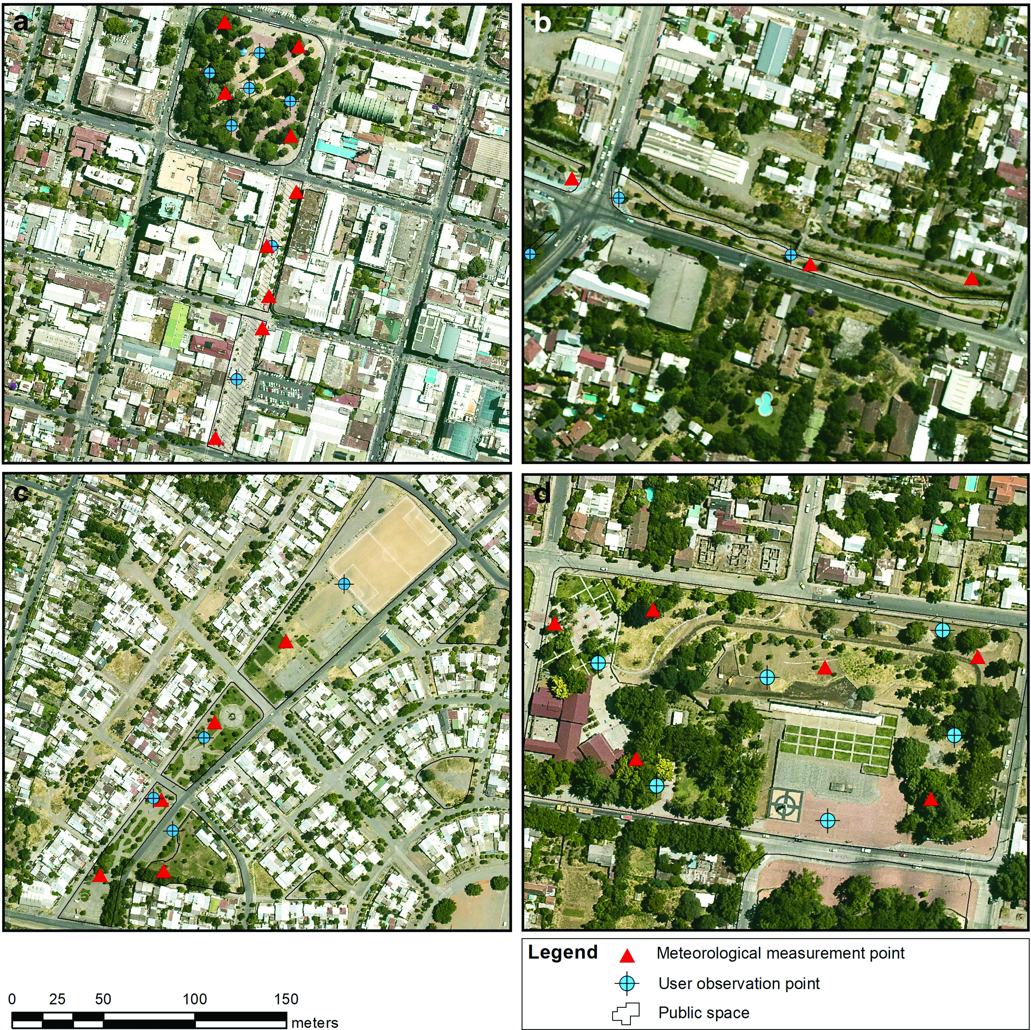
User observation and meteorological measurement points in the public spaces studied.
There was also a clear temporal pattern to the distribution of number of visitors. In general, the parks studied were used more frequently after 6.00 pm, which corresponds to the visit time declared for the spring–summer period in the survey, as observed in the different points photographed at the Plaza de Armas de Chillán, Paseo Peatonal Arauco, and Bernardo O'Higgins Monumental Park at two different times of the day (Fig. 4), which shows more people are present in the public spaces.
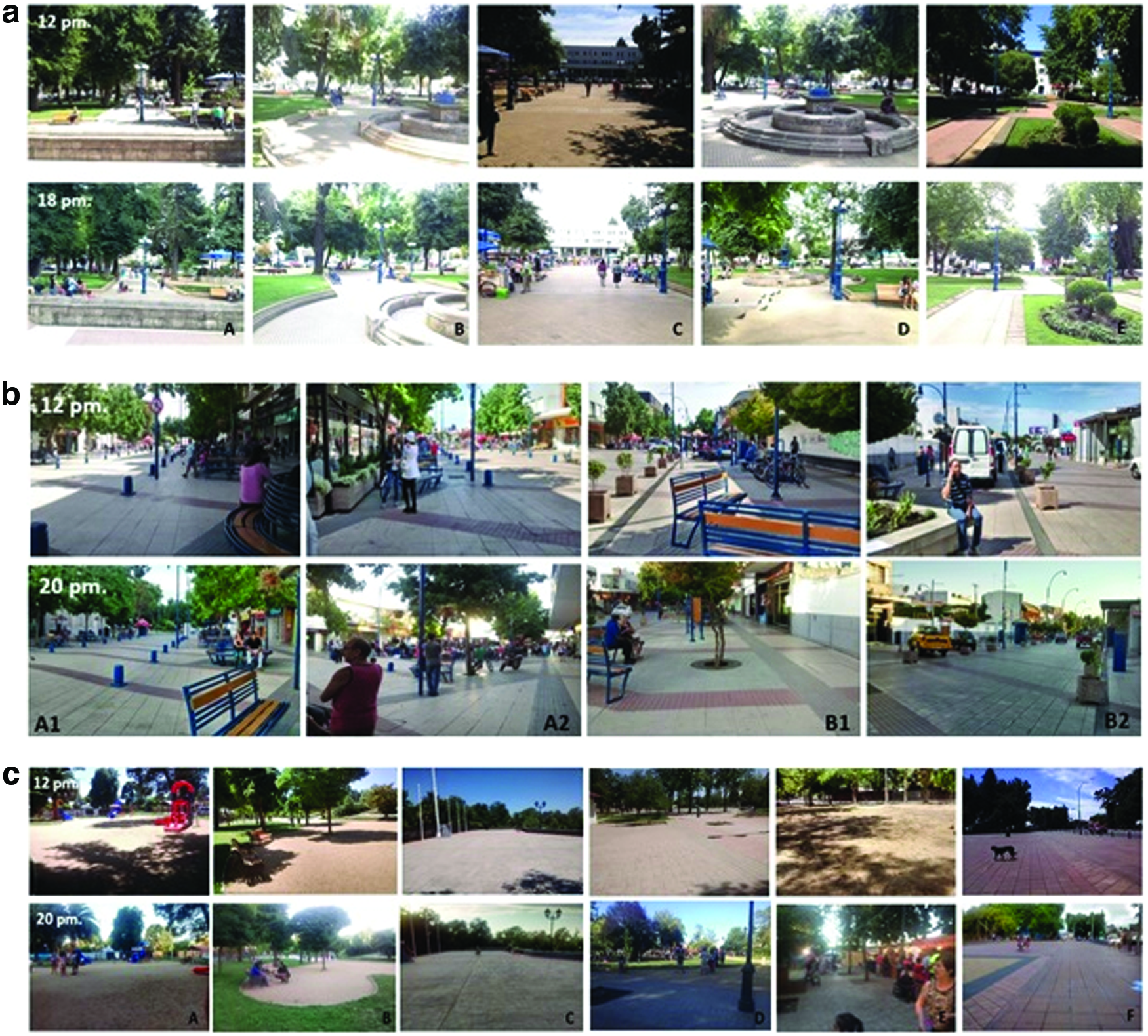
Images of users at noon and dusk captured at observation points in each public space. Source: Personal field archive.
Changes in the use of public spaces according to season
Around 70% of the respondents indicated that their use of public spaces varied with season. The proportion of season-dependent visitors was lower in the case of Plaza de Armas and Paseo Peatonal; however, presumably because of the closeness of these two spaces to zones with high concentrations of shopping and service facilities. In all other public spaces under consideration in this study, visits peak during the summer, this was especially noticeable in the case of the Parque Estero Las Toscas and Parque Monumental Bernardo O'Higgins, which offer additional attractions during summer, such as nearby stalls selling the classic “mote con huesillos” [a summer beverage] in the case of the former and water games (Fig. 5) and a craft market in the case of the latter.

Water games at the Parque Monumental Bernardo O'Higgins (Chillán Viejo). Source: Personal field archive. Color images are available online.
Respondents cited climatic factors, such as heat, cold, or rain, as one of the main reasons for the seasonal differences in their use of public spaces. In some public spaces, such as Parque Bernardo O'Higgins, ∼90% of respondents named climatic factors, such as cold and rain, as the reason for reducing their use during winter, and “better weather conditions”—mainly higher temperatures—as the reason for increasing their use during summer. Users pointed out that “in summer it is warmer and people get out more,” whereas “when it is not warm people do not come out.” Likewise, a user of Paseo Peatonal Arauco pointed out that “in winter, you only see the people who walk along the promenade,” because “in winter it gets darker earlier and it's colder.”
Among the nonclimate-related reasons for the seasonal decrease in respondents' frequency of use of public spaces, they mentioned lack of free time, fewer daylight hours during winter, and the reduction in activities taking place in these spaces.
Preferences when choosing public spaces
A wide range of reasons were given for choosing to visit the public spaces. In the case of all the selected public spaces, except Parque Estero Las Toscas, the most commonly cited reason for visiting was the vegetation. Estero has many shady areas and, as one respondent noted, “it's good to hide from the sun,” so there is a relationship between the choice of this park and the presence of vegetation. Other commonly cited reasons for visiting were that it is a calm place, the presence of benches, security, infrastructure, activities (craft market, water games, artistic events, puppet shows, etc.), beauty, fresh air, closeness, accessibility, and open space. Users of Plaza de Armas de Chillán and Paseo Peatonal Arauco frequently mentioned the centrality of the location (both are on commuter routes and one can walk through the park to shop or carry out other business). Proximity to one's home was one of the main reasons cited by users of the Sarita Gajardo Park (a large proportion of users of this park live in the neighborhood surrounding area); comments included “there is not much room in my house.” Users of other parks made similar comments; for example, a user of Parque Estero Las Toscas pointed out that “it has things that I don't have at home.”
Figure 6 is a word cloud diagram of answers to the question, what would improve your experience in public spaces? The most common response was “nothing” (22%), followed by vegetation, which was mentioned mainly by the users of the Paseo Peatonal Arauco, which has less vegetation than the other spaces we surveyed. Respondents wanted to see more flowers, leafy trees, or more grass. “More shade” was also a popular improvement and it is worth noting that shade is related to the climate quality of public spaces. The availability of water on hot days was also considered important; related suggestions for improvement included “installing drinking fountains,” the provision of “public water” and “pools with water”; a couple of respondents also mentioned “building a pool for children.”

What would make the public space more comfortable? The size of the word indicates the frequency with which each concept was mentioned. Color images are available online.
Climate Injustice in the City of Chillán
Data on climate quality is a useful input for urban planning and design, as it provides information about the state of different areas of the city. We created a multicriterion index of climate quality based on the linear weighted sum of eight climatic and environmental morph factors, namely vegetation cover, atmospheric pollution, urban surface temperature, distance to watercourses, impermeable surfaces, average building height, air temperature, and relative humidity. Information was taken from satellite images, measurements from official air quality stations, and on-site measurements made with meteorological instruments. All factors were standardized (0–1 scale) and weighted according to the recommendations of a panel of 16 Chilean and foreign specialists selected for their expertise in urban climate, thermal comfort, and climate quality. Scores on the climate quality index can range between 0 and 1 and were categorized into five groups: very low (between 0 and 0.2), low (between 0.2 and 0.4), medium (between 0.4 and 0.6), high (between 0.6 and 0.8), and very high (between 0.8 and 1).
First, we calculated average climate quality for the city based on the values of the factors at 4.00 pm during summer, this yielded a high-quality climate score of 0.65 or 0.68, depending on whether the calculation was based on the average or the extreme atmospheric temperature (29.9°C or 35.1°C). We then calculated separate climate quality scores for different areas of the city, these ranged approximately from 0.05 to 0.90.
The average climate quality score for most areas of the city ranged from medium (0.4–0.6) to low (0.2–0.4). The exceptions were areas with lower construction densities and more vegetation, such as gated communities and semirural residential areas (parcelas de agrado in Spanish) inhabited mainly by people in classes ABC1 (northeast of the city), which achieved higher quality climate scores (0.6–0.8). These results are like those obtained in the study carried out in the city of Antofagasta, where a climate–environmental quality indicator incorporating vegetation coverage, urban surface temperature, and SES was used. 27
Although public spaces could counteract the sociospatial differences in environment and climate in the city and provide residents with access to space with a good climate, we found that the climate quality of public spaces in Chillán was related to the SES of the residents in the areas around them. Thus, there were location-based differences in the quality of the climate in public spaces of a particular type. This is the reason why median strips and playgrounds serving ABC1 areas had higher quality climate scores than those serving lower SES areas. The mean difference between the climate quality score of playgrounds serving ABC1 and E residential areas was 0.2.
Similarly, we found that people's perceptions of climate quality were related to the climate quality of the areas in which they lived. The proportion of users who reported feeling thermal discomfort in public spaces was positively related to the climate quality of their area of residence, by that the 100% of users from high SES (ABC1 and C2) neighborhoods (Fig. 7) reporting thermal discomfort in public spaces.
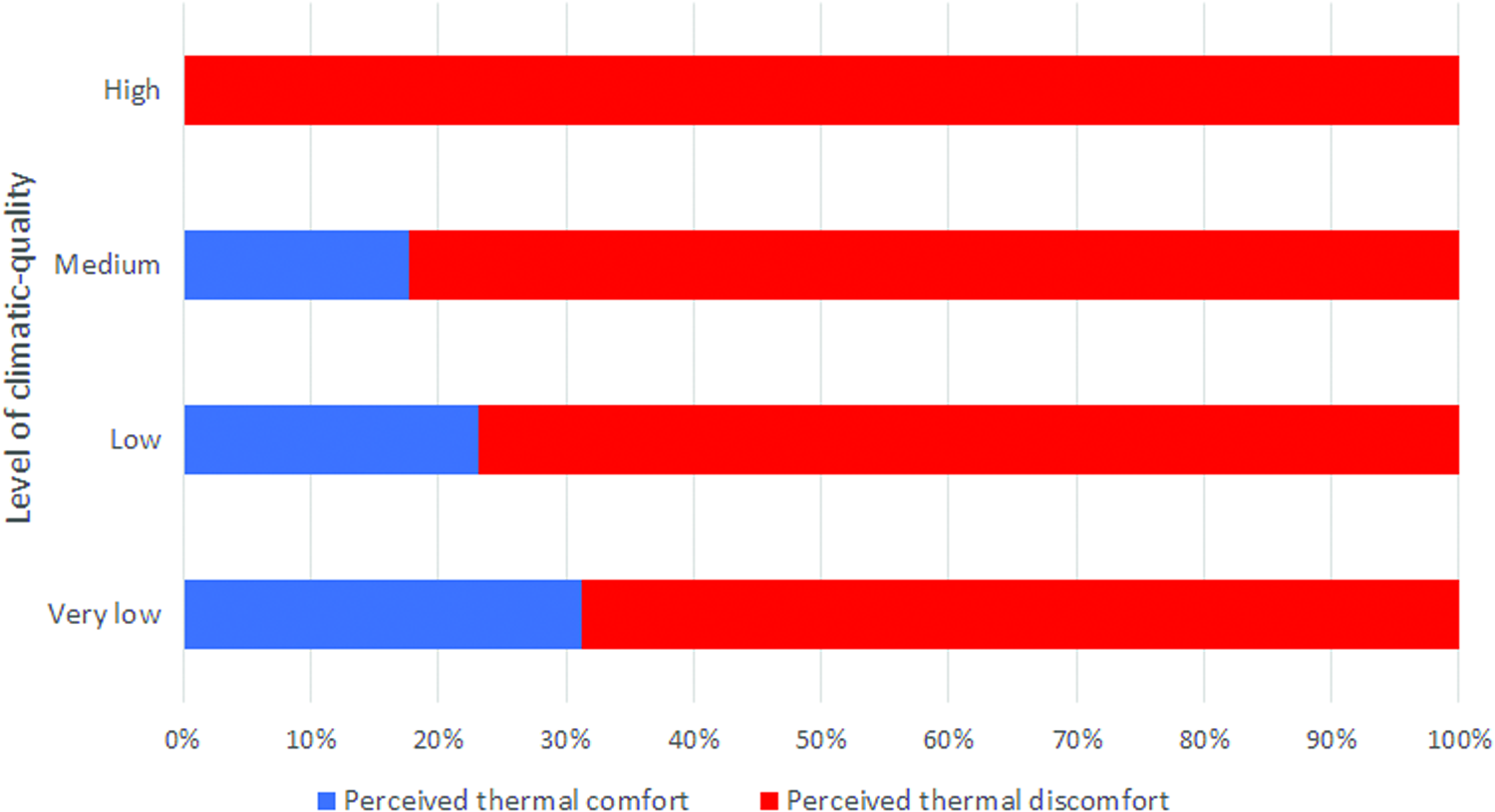
The relationship between average climate quality level of respondents' home environment and their perceived thermal comfort in the public spaces studied. Color images are available online.
Urban Planning and Climate
The city of Chillán does not have any local public policy directly related to climate comfort and public spaces in the city. Communal regulatory plans, 28 , 29 however, set out standards for occupational density, maximum building height, constructability coefficient, and other urban parameters that can affect the urban microclimate and the comfort of users of public spaces.
Comparison of the characteristics of the area around the public spaces we investigated with the criteria for building plot ratio and maximum height set out in the Municipal Zoning Plan showed that there is room for building density and heights to increase. For example, the plan allows a building plot ratio of 1 (i.e., 100% of plots can be built on) in the central area No. 1 (ZC-1) around the Plaza de Armas de Chillán and the Paseo Peatonal Arauco, which means that building density can still increase considerably, as only ∼60% of plots had been built on when we collected our data. Similarly, the zoning plan for the community of Chillán Viejo specifies maximum permitted heights ranging from 14 m in mixed (commercial and residential) zone No. 1 to 20 m in mixed zone No. 2. At the time of data collection, the tallest building in the area around the Parque Monumental Bernardo O'Higgins was 5 m high.
If the permitted maxima for building density and height were reached (Table 1), the sky view factor would be lower, reducing direct exposure to the sun, which might have a positive effect on number of visitors and user comfort in public spaces during the summer season; however, it would also have negative effects on temperature and comfort during winter, making it harder to increase the number of users during winter.
Criteria for Public Spaces and Neighboring Areas as Specified in the Municipal Zoning Plans
Source: Municipal Zoning Plan for Chillán (Ilustre Municipalidad de Chillán 2016) and Municipal Zoning Plan for Chillán Viejo (Ilustre Municipalidad de Chillán Viejo 2012).
The shortage of public spaces, especially in zones with medium and low SES, combined with the low average climate quality of those are constitutes a problem that should be addressed by the authorities, especially given the city's low area of green space per person (1.7m 2 ). These issues need to be dealt with at city council level, but the city councils have very small budgets and can barely cover the costs of maintaining the gardens and public lighting in existing public spaces (this takes ∼3% of the council's annual budget). The city council of Chillán spends U.S. $54,200 per year on the maintenance of Sarita Gajardo Park and so there is no money to implement the design of the final 2 hectares of the 5 originally included in the plan (August 25, 2015, Diario La Discusión).
The creation of new public spaces and work to improve existing spaces rely on resources from the regional or the central government, such as the public space recovery program of the Ministry of Housing and Urban Development (MINVU). The Estero Las Toscas Bicentennial Park opened in 2004 and was developed under this program for a total cost of U.S. $1,104,000. The city council of Chillán also planned to develop the Huambalí Park, located in the locality of Ultraestación, west of the railway station, as part of its urban regeneration program. This 25-hectare project received funding from the Regional Office of the MINVU and costs a total of U.S. $2,714,000 to develop. The amount invested in these two projects far exceeds the amount invested in multiuse games areas, such as that constructed by the city council of Chillán in the Bonilla sector under the central government's “Quiero mi barrio” [I love my neighborhood] program at the cost of U.S. $100,340. This difference in costs, along with the fact that games areas require little maintenance, could explain the proliferation of this type of public space—associated with low–middle SES—in the city.
Recently the MINVU 30 published a document titled “La dimensión humana en el espacio público” [The human dimension of public spaces], which highlights the importance of taking into account social and geographical context in the design and implementation of public spaces in Chile. This document defined five fields of action and sets out a total of 80 design recommendations. Linked to space and comfort, one of the fields of action, there are two recommendations associated with climate: that shelter from the weather (both rain and sun) be provided and that designs should take advantage of the positive aspects of the local climate. The document recommends using pergolas and screens to improve the microclimate of public spaces. The second recommendation is that factors such as the microclimate should be managed by installing passive ventilation or managing the amount of direct sunlight by orienting features appropriately. Both recommendations are in line with climate-sensitive planning and would lead to improvements in the climate quality of the city's public spaces during winter and summer, given the city's Mediterranean climate. 31
Finally, Chile has a national plan for climate change adaptation and, as a corollary, a sectoral plan for adaptation of cities to climate change. 32 Once approved, the sectoral plan, for which the citizen consultation process recently ended, will direct municipal efforts on climate matters in the city. However, the plan focuses mainly on hydrometeorological risks and makes no mention of the concept of urban climate. Hence its consideration of temperature in the city is limited to heat waves and cold snaps, the appraisal of which is usually based on climatic data collected at meteorological stations located outside the city, such as the Bernardo O'Higgins station in Chillán. It is essential that such plans take account of urban climatology and the complex relationship between climate and urban planning and design, including how the design of urban spaces affects thermal comfort and climate quality in every sector of the city.
Conclusion
Chillán is a city of sharp contrasts, including pronounced socioenvironmental differences; this is a situation that calls for action to create more and better public spaces. For people of low SES—mainly those in classes D and E—public spaces provide their only access to good climatic conditions, since they do not have the resources to acquire alternative means of mitigating thermal discomfort, such as air conditioning and ventilation systems. The shortage of parks and green areas in the city reflects the failure of urban planners to prioritize this issue; the creation of more comfortable spaces has been delegated to the private sector. Examples of private green spaces and comfortable amenities include the Schoenstatt Shrine, located south of the city of Chillán Viejo, the Arauco Chillán shopping mall, located in the center, and gated housing (parcelas de agrado in Spanish) in semirural areas. The role of the private sector represents a serious environmental injustice, because it means that access to high-quality public spaces is not equal, with the poorest in society being particularly disadvantaged.
Our review of the main regional and communal land use instruments revealed that there is no clearly articulated strategy for developing an integrated system of public spaces. These instruments, especially the communal regulatory plans, intercommunal regulatory plans, and communal development plans, point out the scarcity of public spaces and the specific lack of green corridors. The lack of green areas, parks, and playgrounds, which is evident from the very low per capita green space provision, combined with by low investment in improvements to the infrastructure and quality of those that do exist, increases the vulnerability of the residents to the potential impact of climate change and the effects of urban heat islands.
Footnotes
Acknowledgments
We thank the eight students from the University of Biobío for their valuable contribution in the survey and assistance with fieldwork. We also specially thank the officials of the city councils of Chillán and Chillán Viejo, who kindly filled out the form, and the 16 Chilean and foreign experts who prepared the climate quality index. This research had support from CONICYT through its National Doctoral Program and the Fondecyt de Iniciación number 11180990.
Author Disclosure Statement
No competing financial interests exist.