
Abstract
Parks play a vital role in the well-being of communities. The spaces covered by parks and their distribution within a city should therefore observe certain standards to provide a fair access for its residents. The purpose of this research was to investigate public parks and their accessibility in Tehran, Iran. We used a comparative evaluation method for the research, in which, along with descriptive statistical methods, a buffering technique in Geographic Information System was also applied. The findings of this study revealed that the indexes of “park ratio” and “per capita” for Tehran parks are below Iran standards. High disparities in the distribution of parks have contributed to unequal access of the inhabitants of the city to these parks. While some residents live within the vicinity of 11 parks, a large part of the city, about 26% of the city's area and 18.67% of the population, is not within the access areas of any park. Creation of smaller parks in certain parts of the city should alleviate the inequality.
Introduction
Background
Urban parks are delineated open-space areas, mostly dominated by vegetation and water, and generally are reserved for public use. 1 In our increasingly urbanized society, these spaces are of a strategic position in the physical environment of cities. 2 As human societies are increasingly urbanized and settled in restricted spaces, park provision is of strategic significance to improve the quality of urban life in cities. 3
Benefits of urban parks
Urban parks are undoubtedly one of the crucial landscapes of most cities and towns that provide numerous environmental and social functional benefits. Parks are major contributors to the quality of life and health of cities' occupants and play a vital role in livability of a city. Parks and other green spaces contribute directly to the public health by reducing stress, mental disorders,4,5 and health inequalities 6 and enhancing the effect of physical activity, 7 perception of life quality, and self-reported general health.8,9 Indirect health benefits are conveyed by providing arenas and opportunities for physical activity, 10 being content of living environment and social interactions, and by different recreational activities. 11 Parks, in other words, are democratic grounds that bring people from different walks of life together, fomenting a sense of community and social vitality that have been progressively lost in the last decades. 12
Accessibility: Definition and criteria
Urban communities are dependent on public parks for their life longevity, mobility, and leisure, and hence, access to parks is one of the major factors affecting the health of communities. 13 It is therefore critical that such resources should be considered in locations where they maximize equal access of individuals. There is evidence that distance from parks and open space is inversely associated with their use. 14 Distance is often mentioned as the main environmental factor influencing the use of a green space. In cities with more parks per population, distance to parks may be a barrier to park use 15 benefits from things. 16 Access is typically defined according to each park's service area, represented by a circle with a radius equivalent to the maximum desired distance of users. 17 This radius method, as it is referred to here, is an example of an accessibility model that determines how fast or far one must travel to reach this circle. It also indicates the spatial relationship between origin and destination, or the degree of connection of a location with others in a region, although it is often defined as “the relative nearness or proximity of one place to another.” 18 Accessibility also refers to the ease with which a site or service may be reached or obtained. 19 Lau and Chiu defined accessibility as an individual's ability to take part in a particular activity or set of activities. 20 Accessibility to urban parks is adequate when the population is in harmony with parks' spatial distribution.
Accessibility is often challenging to quantify, and there is no single best approach for measuring this. 21 The location of parks and their spatial distributions are the two central determinants in the assessment of accessibility. There have been substantial differences in how access and distance to parks and green spaces were operationalized. Stigsdotter et al. used survey respondents' self-report to indicate accessibility for a range of distances, the smallest being 300 m. 22 Richardson et al. used objective measurement 23 and White et al. used means within administrative units averaging 4–5 km. 24 Van Den Berg et al. calculated means for 1- and 3-mile buffers around individual residences 25 and Annerstedt et al. calculated availability within 300 m. 26 Gomes considered 400 m as a reasonable distance for parents taking toddlers and small children to a park for daily outings and playground opportunities and a distance of 300–400 m is seen as a typical threshold value after which the use frequency starts to decline. 27 In Europe, 300 has been proposed as a limit for people to exploit green spaces for recreational purposes and that distance is also believed to represent a person's recreational neighborhood. 28 For U.S. transit planning, the typical standard for walkability is 1/4 mile or 400 m, and walking distance (compared with motorized travel) is a qualitative boundary to determine access. 29 The “Trust for Public Land's ParkScore Index” awards each city points for access based on the percentage of the population living within a 10-minute (half-mile) walk of a public park. 30 DiChiara and Koppelman categorized the parks into five categories of playgrounds, playfields, community parks, district parks, and regional parks, and considered their access areas at a distance of 0.5, 0.5, 1.5, 2, 3, and 10 miles away from the park borders, respectively. 31 According to the standards documented in various resources, Sarhan et al. divided parks into 10 categories and considered the radius of access from 1.4 miles for pocket and miniparks to 1000–5000 miles for conservancy parks. 32 In I.R. Iran, researchers use the criteria set by Habibi and approved by “Iranian Ministry of Housing and Urbanism,” to determine parks' access areas. Habibi and Masaeli 33 divided Iranian urban parks into four categories as follows: neighboring parks with an area of less than 5000 m 2 and an access area of 220–250 m from the park borders, local parks with an area of 4000–5000 m 2 and an access area with a radius of 300–375 m from the park borders, regional parks with an area of 4000–8000 m 2 and a radius of 650–750 m from the park borders, and finally, district parks with an area of more than 8000 m 2 and an access area of more than 750 m from the park borders.
The concept of accessibility, referred to in this article, includes both walkability and park capacity. The areas of parks in Iranian cities, including those of the capital Tehran, have varied widely. Therefore, for larger parks, accessibility is determined by longer distance that must be walkable too.
While many researchers measured proximate value (nearby-ness) of parks up to 600 m from a large park, it should be noted that most of the value is within the first 150 m. 34 Many research findings have indicated that park proximity is essential for a public park usage. 35 For example, people who reside within half a mile of a park, exercise five or more times a week than those who reside farther away from the park. 36 It has been reported that when the distance from a park doubles, the likelihood of park usage decreases by almost 50%. 37 This research hence is to assess parks' distribution and accessibility in the city of Tehran and whether the park locations provide equal access for the city's residents.
Methods
In this article, along with using indicators such as park ratios and per capita park areas, we conceptualized access from a spatial quantitative point of view, including the opportunity to enjoy settings that are in a certain radius of the park. Geographic Information System (GIS) provides an important spatial technique to analyze accessibility.
38
We have used the Euclidean buffer method in GIS for calculating indexes of distance from the nearest park and the overlapping density of the park access area. The access area of each park was determined by a buffer around the park, its radius determined according to the criteria set by Habibi and approved by “Iranian Ministry of Housing and Urbanism.” Accordingly, we consider the radius of park access areas for the parks with areas of less than 5000 m
2
and more than 8000 m
2
, 220 m and 800 m from the park border, respectively. Considering 3000 m
2
difference in areas and 580 m difference in the radiuses of the two categories of parks, the radius of access areas (ri) for any park with an area between 3000 and 8000 m
2
can be calculated as follows:
where Si, the area of park i.
The data used in the article, including those of the 2016 Iranian population census and 2016 land use parcel levels, were updated through direct observations and geometries.
Study Area
The study area was Tehran city. The city has an area of 66,277 ha and a population of 8.7 million. 39 Tehran is the largest city and the capital of Iran. It is located in alluvial fans of the southern Alborz foothills and its average annual precipitation is about 230 mm. The city is divided into 22 municipality districts (Fig. 1).
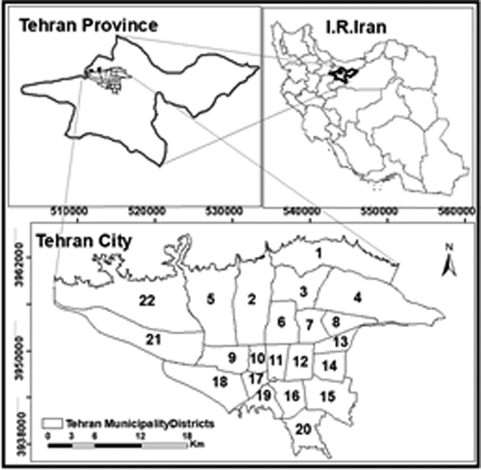
Location of the studied area.
The location and climate of Tehran have been the reasons behind this city being selected as the capital of Iran since 1785. In many travel logs that were written one to four centuries ago, the city has been praised for its ample orchards and trees. 40 However, in the last few decades, massive increase in population and physical growth have led to expansion of the city into orchards and agricultural lands with impacts on green spaces by the 1970s. Tehran had 75 parks, which in conjunction with forestry on the outskirt of the city, the green space was totaling 2937 ha. However, in the last few decades until 1985, despite the construction of more than 60 parks, green space per square meter is only 0.5 m 2 due to expansion of the city. Construction of 1730 parks by 2012 increased green space within the city and its close periphery to 40,000 ha. More recently, with the construction of an additional 200 parks, the per capita green space has reached 25 m 2 . However, despite the new parks, still less than 10% of the city's area is covered by green spaces. 41
Findings
Park ratio and per capita urban parks
The land use map and information provided by the “Organization of Parks & Green Spaces of Tehran Municipality,” show that Tehran at present has 909 urban parks covering 5035 ha, 7.6% of the city's area (Table 2 and Fig. 2).

Location of urban parks in Tehran city.
As shown in Table 1 42 , district 4, located in northeastern Tehran, has the highest share of parks than any other district, as 16.8% of its area is covered by urban parks. Here, Levizan Park alone covers 13.2% of the area, and Tello Park has a surface area of 1000 ha. 43 In district 22, located in the northwest of Tehran, nearly 14% of lands are covered by urban parks. Chitgar (950 ha), Latmal (100 ha), and Rabbit (67 ha) are the three major parks in this district. 44 Likewise, in district 15, just over 10% of the land is covered by parks. In contrast, in districts 9, 7, and 13, urban parks cover less than 1% of their lands. District 9 although had benefited from a substantial number of orchards and agricultural land, most of the lands were later allocated to the construction of airports and numerous industries. Districts 7 and 13, being the hub of Tehran since their establishment, also suffer from a low park ratio as most of their land and orchards are allocated to residential and administrative use. In general, in six districts of 2–4, 15–16, and 22 the index of “park ratio” is higher than Tehran's average (7.6%) and is lower in other 16 districts.
Park Ratio and Per Capita in Districts of Tehran Municipality
The average of per capita urban parks in Tehran is 5.8 m 2 . In district 22, this share is 79.2, which is 13.6 times higher than this average. Nonresidential land usage such as Chitgar Park, Azadi Stadium with an area of 460 ha, as well as industrial towns and freeways have contributed to the lower population density of this area and hence the high share of urban parks. In this indicator, 4 districts of 3, 4, 21, and 22 benefit from a higher than Tehran average in contrast to the other 18 districts. In 7 districts, the index is less than 1 m 2 and in 11 districts it is 1–5 m 2 .
Park accessibility
The indicators outlined above can only provide an overall situation of an area in terms of having spaces as a park, but geographical distribution of the parks and their accessibility are varied in any part of these areas. So we have applied buffer tools in GIS to analyze urban park accessibility, and the proportion of the population that resides at certain distances from the nearest park was calculated using this tool (Table 2).
Distance Between Residential Blocks and the Nearest Park
A third of Tehran population resides at a distance of less than 100 m from the nearest park and for slightly over half of the population this distance is less than 300 m. Also, about 90% of the population resides at a distance of less than 800 m from the nearest park (Fig. 3).
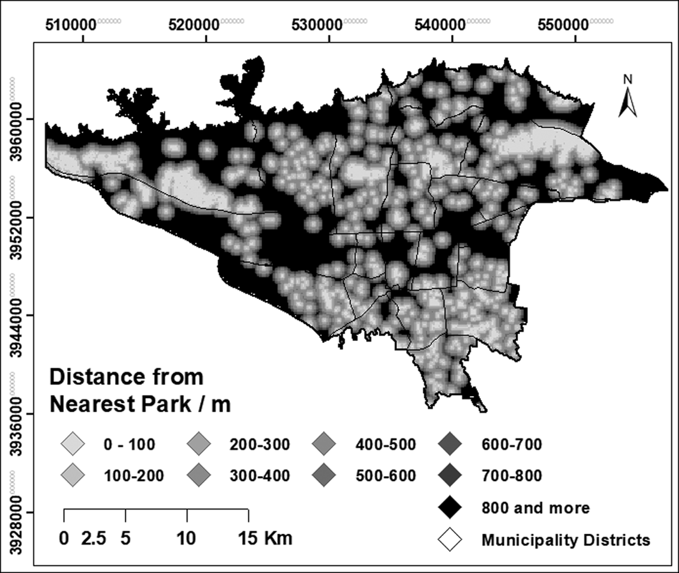
Distance from nearest park.
The access area of each park was estimated through drawing buffers in GIS according to the abovementioned criteria (Table 3 and Fig. 4).
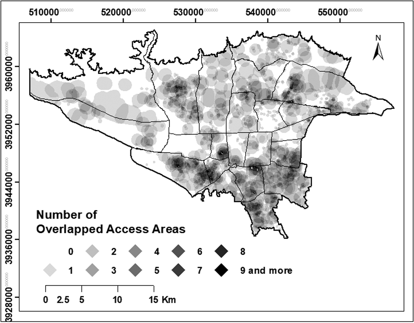
Access areas of parks and their overlaps.
Coverage and Overlapping of Parks' Access Areas
Approximately 26.22% of the city's area, where 1,061,020 people are residing, is outside the parks' access areas (Table 3). Also, nearly 1/3 of the city's area, accommodating 1/5 of the population (about 1.66 million), lies inside the access area of only one park, while 0.69 ha of the city's area and its population of 320 people are within 11 parks' access areas. More than half of the city's area (59.8%), housing about half of the population (52.74%), is inside the access area of 1 to 3 parks.
The most overlapping park access areas, 11 parks, belong to districts 4 and 16. In districts 5–8, 10, 15, 17, 18, and 20, a maximum of 10 park access area is overlapped, while in 4 districts of 1, 9, 21, and 22, the maximum overlapping of parks' access areas is only 5. In district 14, this is 9. In districts 12 and 3, there are a maximum of 8 overlaps of access areas of parks. In districts 7, 11, 13, and 18, it is 7, and finally, in district 2, there are 6 overlaps of access areas of parks.
Southern and southeastern parts of Tehran benefit from a large number of small parks improving the overlapping density of the access areas of the parks (Fig. 3). On the contrary, in the west and northwest of the city, although the proportion of the land covered by the parks is higher, the significantly larger parks have reduced the coverage and overlap (Table 4).
Percentage of Inhabitants in 22 Districts of Tehran Municipality in Relation to Overlapped Park Access Area in These Districts
While in district 7, nearly half of the inhabitants and in districts 22, 1, and 11, about 1/3 of them do not reside in any park access area, in districts 16, 18, 20, and 15, more than 95% of residences live in at least 1 park access area.
Conclusions
Public parks are a vital component of the urban landscape. The health and quality of life in each city depend largely on the existence and distribution of these parks to ensure equal access for the city's residents. Standard guidelines established in Iran advise per capita parks of at least 13 m 2 in view of the natural, social, and cultural circumstances. 45 The Iranian Organization of Land and Housing has recognized a standard of 5–10 m 2 per capita 46 and some researchers have proposed a 9 m 2 . 47 Tehran park space per capita is significantly lower than any of these guideline values. The park space per capita is also substantially lower than the average for all other Iranian cities (11.5 m 2 ). Per capita urban parks in five other highly populated cities, namely, Mashhad, Esfahan, Karaj, Shiraz, and Tabriz, are 4.18, 21.3, 0.87, 1.14, and 7.56 m 2 respectively. 48 Tehran falls behind Esfahan and Tabriz, but surpasses other cities. Park ratios in these cities are 3.84, 23.85, 0.97, 0.17, and 5.64%, respectively, 49 with only Esfahan having a higher park ratio than Tehran.
High disparities in the distribution of parks in Tehran have also caused unequal access of its residents to existing parks. While a small percentage of the population resides in access areas of 11 parks, a large part of the city, which covers about 26.2% of the city's area and 18.7% of the population, is not within the access areas of any park. The substandard of parks per capita in the city of Tehran and their unequal distribution demand creation of smaller parks especially in the northwestern and southwestern regions of the city to improve quality of life for its residents.
Footnotes
Funding Information
No funding was received for this article.