
Abstract
Cancer Alley is an 136,794 meters stretch of chemical and industrial plants along the Mississippi River between New Orleans, Louisiana, and Baton Rouge, Louisiana. Since 2005, the area has experienced more than two dozen hurricanes with major rainstorms in between. Cemeteries, although just as vulnerable to storms and cancer-causing chemicals as the local population and natural environment, are overlooked casualties of frequent hurricanes and plant siting. During hurricanes and annual flooding, cemeteries in South Louisiana sustain significant damage such as dislodged coffins, difficult to reintern remains, and burial records damaged or destroyed. African American cemeteries are vulnerable to climate change impacts such as flooding, are often inaccessible, undocumented, and rarely recognized as environmental justice concerns, until now. Recently, environmental justice activists have mobilized to resist a Formosa plant's siting close to a historic black cemetery in St James Parish. The authors hypothesized that the Formosa siting is not an isolated case but instead reflects a pattern of racialized multihazard exposure of African American people and cemeteries. They created a database of cemetery locations—many of which were previously unmapped—based on the race or ethnicity of those interred in two parishes. Then, they performed a spatial analysis comparing cemeteries' exposure to flood hazards and proximity to hazardous chemical sites based on racial makeup. Findings show that black cemeteries have more multihazard exposure than other cemeteries due to accessibility and flooding. Results indicate that racialized multihazard exposure of cemeteries should be an emerging concern of Gulf Coast disaster recovery planners and researchers.
INTRODUCTION
Until recent years cultural resources, such as cemeteries, have rarely been the focus of environmental justice struggles. 1 Today these institutions are recognized as being both historically significant and central to African American identity and resilience. 2 For communities of color, these resources provide a timeline of historical events, but it embodies intergenerational values, morals, and traditions that support social cohesion. 3
In communities along the Louisiana Mississippi River Chemical Corridor, also known as Cancer Alley, these resources are at risk of being destroyed due to industrialization and multihazardous impacts. 4 Historically communities of color, such as those along the Louisiana Mississippi River Chemical Corridor, have experienced a disproportionate impact when faced with multihazardous events, 5 placing both the living and the nonliving at risk of hazardous impacts. This study uses multihazardous impacts to refer to the risk of impact by anthropogenic (environmental pollution and pollutant) and hazardous natural sources (flooding). 6 Two notable examples are the struggles to protect burial grounds near the Shell Plant in Ascension Parish and the Formosa plastics plant in St. James Parish.
In March 2018, private archaeologists performing cultural resource surveys for Shell Oil Refinery identified enslaved persons' burial sites on the Bruslie and Monroe Plantation cemeteries. 7 The cemeteries' location—near more than one chemical facility—made it difficult for residents to visit their loved ones because accessibility to the cemetery decreased. 8 By the end of March, Shell made visits to the cemeteries available to descendants by appointment. 9 Gail Leboeuf, remarking on the restriction of access to her ancestor, explains that “My grandmother wasn't a slave. But she is a slave now on the Shell plantation.” 10
St. James Parish's struggle against the Formosa plant siting indicates that the Shell case was not an isolated incident. Formosa proposes 14 separate production and utility plants on >9.30 sq km within St. James Parish. In 2014, St. James Parish created a land use designation, Residential/Future Industrial, which paved the way for this plant siting and has had significant impacts on African American residents' cultural and community anchors in St. James Parish's Fourth and Fifth Districts.
In the report, “A Plan without People,” Louisiana Bucket Brigade and Rise St. James brought attention to one of those impacts, stating that the Parish land use plan “includes a buffer map that acknowledges and protects schools and churches in some parts of the parish while ignoring and omitting churches and schools in the Fourth and Fifth Districts.” 11 Finally, although Parish district council members kept two industrial sites out of white communities, the same protections were not afforded to the Fourth and Fifth Districts in St. James. Notably, the Fifth District, where the Formosa complex is proposed, already has a high concentration of industrial plants and is 85% black. 12
Over the past year (2019–2020), the proposed Formosa plastics plant siting in St. James Parish has sparked a contentious battle to protect and secure access to a cemetery. 13 A group of descendants planned to honor their ancestors at a gravesite in Louisiana, where Formosa Plastics Group planned to build a plant. They planned for the event to occur on June 19, 2020, when African Americans celebrate liberation from slavery. Claiming that holding the remembrance at the cemetery would prove dangerous due to ongoing plant construction, Formosa prohibited the descendants' entrance to the site. 14 Also, the plant disputed claims that formerly enslaved persons were interred at the location.
A lifelong resident of St. James Parish and leader of Rise St. James, Sharon Lavigne has contested plant siting and cemetery access issues. Rise is a faith-based grassroots group of residents from St. James Parish, where there were once plantations (Fig. 1). 15 Now the area is filled with historically black settlements riddled with pipelines and industrial facilities. 16 A community advocacy organization, Rise focuses its efforts simultaneously on environmental justice and heritage conservation of sites associated with the formerly enslaved in the St. James community. Along with the Louisiana Bucket Brigade and the Center for Biological Diversity, Rise filed lawsuits to access burial sites and halt the plant construction.

Image of longtime St. James Parish resident and activist, Sharon Lavigne.
Shell and Formosa cases are clear examples of multihazard risk to people and cultural properties. Industrialization and multiple hazards impact cemeteries, placing them at a disproportionate risk of being destroyed. Inhibiting visitation weakens social bonds sustained through these cultural practices and lessens the frequency with which descendants can maintain or mitigate harm to cemeteries. Local land use planning increases exposure to more cancer-causing agents, residents' susceptibility to detrimental health impacts (including asthma, COVID-19, and infertility), whereas impairing their capacity to mitigate harm to cemeteries postdisaster.
To fully understand the importance of integrating African American cemeteries into multihazard mitigation planning, this study defines the scope and scale of cemeteries' racialized multihazard exposure in two parishes. To meet this objective, authors (1) create a cemetery database in two parishes along the Louisiana Mississippi River Chemical Corridor and (2) perform spatial analysis of their exposure to petrochemical pollutants and susceptibility to flooding based on the racial makeup of those interred. Drawing on advocacy groups' study of land use on African American settlements along the corridor, the purpose of this research study is to determine if cemeteries predominantly interring black individuals are disproportionately exposed to multihazardous impacts as a consequence of those same policies and flood risk. Cemeteries are spatially analyzed based on race, proximity to chemical plants, and flood exposure, along with the 2010 population concentrations to detect possible patterns of racially disproportionate multihazard exposure.
BACKGROUND: CANCER ALLEY
Since the early 1950s, >135 petrochemical companies who regularly release toxic chemicals have proliferated along the Mississippi River. 17 Those driving the 85 miles between Baton Rouge and New Orleans will see a landscape filled with several small unincorporated communities and villages of color situated within nine parishes: Ascension, East Baton Rouge, West Baton Rouge, Iberville, St. James, St. John the Baptist, Orleans Parish, and St. Charles. 18 Historically the area was predominantly composed of descendants of enslaved Africans who acquired former plantation land near the river. 19 Once emancipated, black residents acquired sugar cane plantation land sold at a low cost, in part, due to its proximity to low-lying wetlands placing residents at risk for hazardous flooding impacts. Traces of Jim Crow social norms still inform relationships between African Americans who live closer to the river and whites who live further away from the river.
By the late 1950s, chemical companies began to take root within the area leading to the growth of the great “Mississippi Chemical Corridor,” otherwise known as “Cancer Alley.” 20 Today Cancer Alley is home to 1.6 million residents; the industrial facilities are the prime sources of taxable revenue. 21 The industrial facilities within this region collectively discharge ∼57.9 million kilograms of toxic emissions into the air, soil, and water each year. 22 Bullard and Wright's (2009) research findings show that the release of toxic emissions within these socially vulnerable communities creates adverse health effects, hence the nickname Cancer Alley. 23 The regular release of toxins (i.e., ammonia, methanol, sulfuric acid, hydrochloric acid, hydrogen sulfide, ethylene, and benzene) has had a direct impact on the corrosion of physical infrastructure. 24
The presence of these industrial facilities has damaged African American's cultural landscapes, including their cemeteries, significant anchors of historically African American communities. Cemeteries are spaces in which intergenerational transfer of values and traditions occur, connections to formerly enslaved ancestors can be made, and in some cases are the only evidence that an African American settlement once existed. In communities located in Cancer Alley, cemetery preservation is critical to community resilience because these historically significant sites serve as historical repositories—body archives—whose headstones, obituaries, and funeral program biographies reveal settlement patterns and genealogy. Descendants of those interred return for homecoming celebrations in historic churches and to maintain gravesites. Hazardous chemicals degrade residents' health, inhibit their ability to visit sites that define African American placemaking in the South.
This article investigates the impact of industry proximity and inadequate stormwater protection on black cemeteries. Of the nine Louisiana parishes that comprise the Mississippi River Chemical Corridor, this study's scope is cemeteries in two parishes: Ascension and St. James. Ultimately, we selected this geographical region as our study area because of its (1) rich cultural and sociopolitical history and (2) continued risk of multihazard impacts, and (3) the contrasting density and land development in the two parishes.
LITERATURE REVIEW
Little environmental justice scholarship has focused on multihazard threats to African American burial grounds along Cancer Alley. Some research about cemeteries in other regions documented the ways industrial encroachment delegitimizes cemeteries' sociocultural significance, 25 and others have discussed the value of specific methods being applied in cemetery mitigation planning posthurricane. 26 However, few scholars have focused on the multihazard threats to burial grounds in Cancer Alley. 27 This article seeks to address the literature gap and practical knowledge about the relationship between land use policy, cemeteries, race, and multihazard exposure in Louisiana's Cancer Alley.
To understand the natural and socio-legal context, which fosters cemeteries' multihazard exposure in Cancer Alley, we examined hazard, legal, geography, planning, and historic preservation scholarship. To determine the appropriate methodological approach, case selection, and scale for analyzing African American cemeteries and their multihazard exposure, the team also examined similar research conducted by advocacy groups working along Cancer Alley 28 and spatial analysis on Texas' historic African American communities in the path of frequent hurricanes. 29 Furthermore, we examined cultural resource management reports and research on why increased attention to and coordination with disaster agencies to protect cultural resources is necessary. 30
The authors use the Department of Homeland Security's (DHS) working definition of multihazard exposure. DHS often refers to all hazards that “encompasses all conditions, environmental or manmade, that have the potential to cause injury, illness, or death; damage to or loss of equipment, infrastructure services, or property; or social, economic, or environmental functional degradation.” 31 However, our focus is on specific thematic hazards: flooding, hazardous plant siting, social degradation, and systemic racism. Accordingly, the Cancer Alley context leads us to use the term multihazard in a way that connotes “more than one hazard.” 32
Veterans of the environmental justice movement have long pointed to plant siting as evidence of systemic racism. 33 Thus, the authors argue that multihazards are racialized because land use is often occurring in ways informed by systemic racism and necropolitics—the systems that impose how particular populations should live and die. 34 Black Geographies scholars such as Bill Williams argue that the contemporary concentration of chemical risk exposure in Cancer Alley exemplifies this pattern. Williams writes that “the processes and consequences of the chemical intensification of plantations were shaped by the racial politics of the plantation, and that chemical intensification represented agrarian racism by other means.” 35 The antiblackness that Williams describes created a foundation for the disparate treatment of black bodies in life and death along Cancer Alley.
Another cause of encroachment on cemeteries in the area is statutory. Keehan explains that Louisiana's Napoleonic Code, “which requires proof of ownership, made it difficult for industries to purchase African Americans' homes and land. Therefore, petrochemical plant owners had difficulty buying most of the historic African American homes in the area. The result of these land use conventions and the law is the haphazard landscape found in Cancer Alley today, where homes are located on industrial plant fence lines, and historic cemeteries are boxed in by industrial plant property.” 36
Peer-reviewed research centered around disaster impacts and management for cemeteries is sparse. However, The Chicora Foundation created an informative cemetery disaster planning booklet describing likely disasters that can damage cemeteries, including tornadoes, river and nuisance flooding, earthquakes, tornadoes, and drought. 37 Hurricanes result in wind and water damage in cemetery landscapes and also produce storm surges and flooding. This flooding makes the cemetery inaccessible and uproots coffins from the earth. Flooding in cemeteries also occurs due to massive rainstorms, spring thaw, levee breaks, and new development.
The damage found within burial grounds depends on the geographical setting and location of communities. The magnitude of the damage also depends on the deposition of soil, sand, and litter, gravestone displacement, gravestone damage, erosion, and disinterment of caskets. 38 Photos show the visible damage but measuring that impact is also necessary. “Disasters can cause significant damage that can move, compromise, or destroy stones. For instance, water has an incredible force, weighing about 1700 pounds per cubic yard.” 39 Burial displacements and gravestone dissociation require retaining expensive expertise such as a forensic pathologist.
Furthermore, mass internment, similar to that which occurred in Louisiana after Hurricanes Isaac (on August 2012) and Katrina (on August 2005), was difficult to address because of the ambiguity of responsibility for various cemeteries. To avoid costly technical assistance and trauma, cemetery managers need a plan that satisfies the full disaster management cycle: mitigation, preparedness, response, and recovery. 40 However, the preparedness for cemetery disaster management varies depending on the geographical location and surrounding communities. Owing to the variation, a new assessment system for cemeteries (often individually tailored by site) is required to create the appropriate disaster management plan. 41
Recently, planning scholars—specifically those writing in the historic preservation subfield—write that cemeteries are valuable 42 and endeavor to raise cultural resource managers' awareness of how they can mitigate various risks to cultural resources and equitably allocate resources to protect invisible, vulnerable, and inaccessible spaces. 43 Planning literature, particularly that concerned with disaster mitigation, says that cemeteries serve as
statistical and sociological proxies of the communities and their histories. As such, cemeteries enable amazingly accurate reconstructions of historical community, even in the absence of more traditional records and documents. The loss of cemeteries can then be tantamount to the loss of communities and their histories and identities, even more so for those communities that have declined or no longer have any physical presence except for their cemeteries. 44
Ravankhah et al., writing from a cultural resource management perspective, interdisciplinary systems perspective. 45 They point to the lack of integrated planning that leads to the endangerment of resources. For example, the authors warn that well-intentioned interventions before or after disasters can compromise cultural resources' authenticity and physical integrity due to poor integrated planning. Attention to primary and secondary risks are required so that both humans and historic sites are protected simultaneously.
Planning literature has called for more coordination between disaster mitigation planning and cultural resource surveying efforts to highlight historic resources at risk. 46 Federal Emergency Management Agency (FEMA) promoted this integrated approach and encouraged public agencies to leverage geographic information system historic resources layers over maps of hazard-prone areas to identify resources under threat. 47 However, developing these mapping systems is often challenging due to the expense and time required to build these applications.
Land use planning scholars point to the lack of attention to cultural resource protection in adaptation planning related to mitigating climate change impacts. 48 They argue that land use decision-making (siting) should consider various social and scientific factors, including defining the problem and participants' and stakeholders' values and objectives. 49 Furthermore, unlike ecosystem-based planning, land use and other urban planners have to be proactive and forecast risk and act on behalf of cultural resources such as cemeteries because they cannot act or adapt independently. 50
To develop the methodology for this study, the authors examined similar projects. Crowdsourcing data about vulnerable cemeteries in the African diaspora surfaced in literature in two places: the Caribbean and Texas' historic black settlements called freedom colonies (FC). Mueller and Meindl took georeferenced photographs and used them to build a database of 542 Caribbean small island cemeteries. 51 The authors then overlaid georeferenced data with elevation data, which made evident the role of elevation in assessing cemetery vulnerability. The basis for the method in Mueller and Meindl's study is called the Bruun's rule: “Sea level rise is a problem not just because of the risk of inundation, but also because increased sea level will also lead to increased rates of erosion.” 52 However, in the parishes, elevation and coastal proximity are further complicated by levee locations.
Relatedly, literature about African American communities in Texas known as FC frames risk as racialized based on a tripartite framework based on vulnerability, access, and visibility. Similar to communities in Cancer Alley, FC were found in low-lying areas, largely unmapped, and hard to access. 53 Spatial analysis of census and crowdsourced settlement location data and FEMA—Hurricane Harvey Impact shows that the storm impacted 64% of the 357 mapped FCs in Texas. 54 The authors also used this tripartite framework and some of the Texas Freedom Colonies Atlas database development methods to construct the two-county cemetery database.
However, a gap is apparent in the literature about cemetery vulnerability and risk concerning chemical plants. Although several mass media outlets cover parish level conflicts over access to cemeteries being inhibited by plant siting, building, and land use, little is discussed about this issue in peer-reviewed literature. Instead, the literature on cemeteries and hazards covers more about the environmentally hazardous chemicals that come from caskets and embalmed bodies. Conversely, little literature speaks to the legal and social barriers chemical plants pose to those attempting to visit and maintain cemetery sites that happen to be near chemical plants.
When plants inhibit access to historic sites, legal and social barriers emerge, impairing social cohesion, a dimension of a community's capacity to bounce back or be resilient in times of disaster. Social capital and cohesion are integral to maintaining and sustaining the social networks necessary in disaster times. 55 Cemetery access and visitation are practices that support social cohesion because these activities create spaces and moments when dispersed stakeholders and communities can reinvigorate their community-building capacity. 56 Rise St. James has deployed these practices enabling the group to organize resistance to the government's hazardous land use decisions. Little peer-reviewed literature offers ways to define, document, and study plant siting and flooding's multidimensional multihazard impacts on cemeteries and community cohesion in historically African American hamlets along Cancer Alley.
METHODS
Case selection: Ascension and St. James Parish cemeteries
The study's scope was Ascension (high density) and St. James Parish cemeteries (rural). Some black cemeteries are in rural areas away from development, whereas others are located near busy traffic stops with few to no buffers from traffic accidents and car emissions. Typically, African American (black) cemeteries in these Louisiana Parishes are located near churches or along the plantation borderlands. Given the density of chemical plants in St. James and Ascension Parishes, almost all cemeteries are in proximity to chemical plants.
Although a comprehensive field study was not conducted to compare cemetery maintenance and conditions by racial composition, one of the authors made a site visit to the Moonshine and Mt. Pilgrim Baptist Church Cemetery on August 23, 2020, to document examples of local burial ground conditions (Fig. 2). A train track and a series of mobile homes split Moonshine Cemetery into two sections. A weakened chained fence surrounded Mt. Pilgrim Baptist Church Cemetery, the site had overgrown vegetation, and its burial crypts were sinking into the ground. Figures 3 and 4 indicate the needs of black cemeteries'—concrete crypts required pressure washing and overgrown vegetation needs cutting. The surroundings indicate that these conditions may impact the regularity with which descendants may access the grounds to perform maintenance.
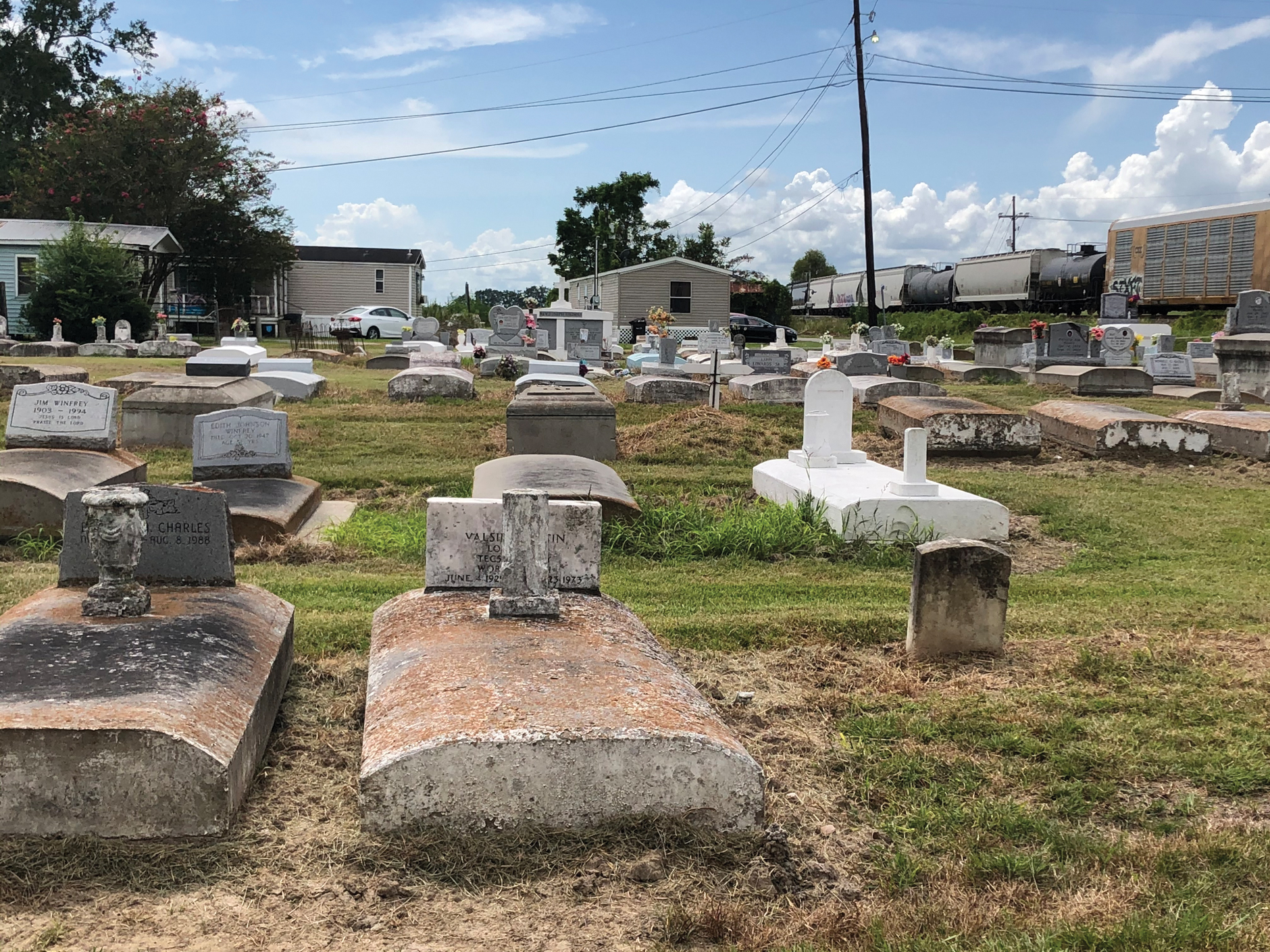
Image depicting Moonshine Cemetery in St. James, Louisiana (St. James Parish). Note the cemetery's proximity to the train track in the right corner and mobile homes. Color images are available online.

Image of Mt. Pilgrim Baptist Church Cemetery in Geismar, Louisiana (Ascension Parish). Note the overgrown vegetation, tree litter, and displaced burial crypts. Color images are available online.
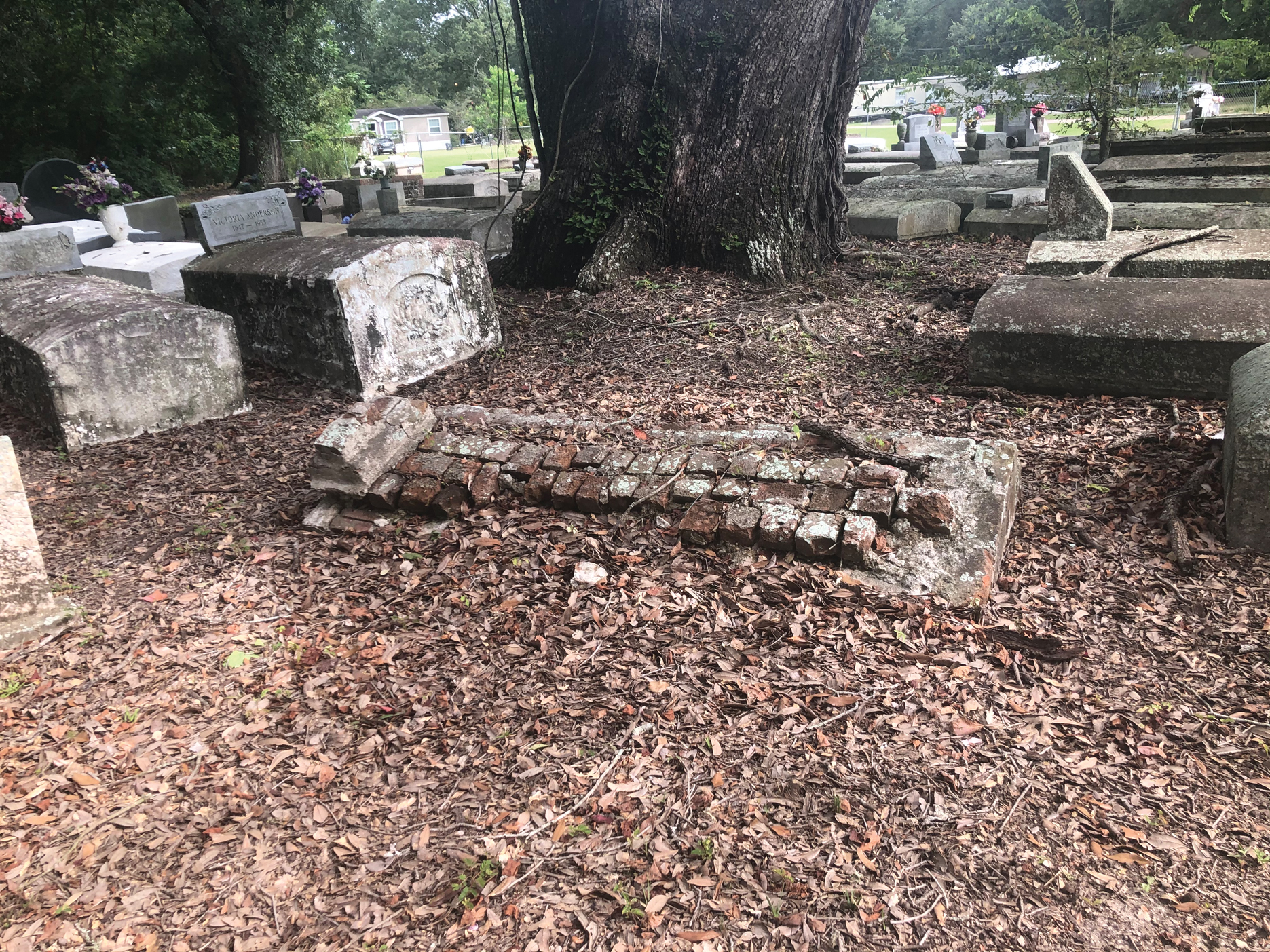
Image of Mt. Pilgrim Baptist Church Cemetery in Geismar, Louisiana (Ascension Parish). Note the overgrown vegetation, tree litter, and displaced burial crypts. Color images are available online.
To identify the cemeteries' racial composition, the authors conducted a content analysis of burial site data. The racial composition of cemeteries in the database was determined through visual analysis of cultural signifiers in cemeteries. Cultural signifiers are “signs and symbols used for interpretation of specific cultures throughout the world.” 57
There are several sociocultural signifiers found on black cemetery burial plots that are unique to African American culture. 58 It is not uncommon for black cemeteries to have “colored,” “negro,” or “African American” in the cemetery title. Headstones in black cemeteries revealed cultural and religious affiliations such as the names of black Greek organizations. For example, Delta Sigma Theta Sorority Incorporated and Alpha Phi Alpha Fraternity Incorporated—to African American sororities. Headstone inscriptions contained names African Americans frequently use to refer to grandmothers and grandfathers such as “Madear,” “Big Mama, or “Big Papa.” The authors used the aforementioned cultural signifiers to confirm or suggest the cemetery's racial composition to perform the content analysis.
In this study, two primary sources enable the authors to identify cultural signifiers—Find a Grave and Ancestry. 59 The two sources provided images of headstones, grave portraits on headstones, and names of cemeteries. Grave portraits are headshots of the deceased. Each image was carefully analyzed to determine the racial composition of the cemetery.
Database methodology
There is not a centralized publicly available database of cultural resource survey data in Louisiana. To locate data and records of African American heritage resources, researchers must search public and private repositories. Whereas governmental agencies increasingly rely on crowdsourced databases to improve information systems. 60 Researchers, such as those involved in The Texas Freedom Colonies Project Atlas and Study, surveyed African American settlements' descendants to collect and aggregate data about unmapped places. 61
Given the limited publicly available databases on African American cemetery locations, especially those with formerly enslaved persons interred in Louisiana, the authors relied on some crowdsourced interfaces to develop the cemetery location database. Authors developed a database based on a spreadsheet that includes cemetery names, cities, parishes, the year established, demographics, zip codes, latitude and longitude, number of nearest facilities, and alias names. Demographics of those predominantly interred in cemeteries are black, white, mixed, Jewish, or others. The authors define mixed cemeteries as those burial grounds containing at least one black burial.
Interfaces accessed for the study's database, Find a Grave and Ancestry, include some crowdsourced data. 62 The memorials and burials on Find a Grave, for example, include pictures of the deceased, which provide visual confirmation of racial identity. Find a Grave also allows volunteers to upload obituaries of the deceased, containing photos and membership in black churches and Greek Organizations. When Find a Grave page did not contain pictures of those buried, an Ancestry database search was performed. The Ancestry database provides access to census documents, voter registration cards, military draft cards, birth certificates, and marriage licenses, helping researchers identify a person's race or ethnicity. 63
Following are a series of tables illustrating the number of cemeteries by demographics, verified using Ancestry, Find a Grave, and a combination of both sources together, as seen in Table 1.
The Number of Cemeteries Verified Using Find a Grave and Ancestry
Mapping multihazard exposure
This study's tables and maps illustrate multihazard risk by cemetery by race in the two parishes. To illustrate the multihazard exposure of cemeteries based on racial composition, the authors created a database. They used database contents to develop layers, which enable visualization of the spatial relationship between cemetery locations, flood exposure, and industrial facility proximity. Burial sites were georeferenced to create a cemetery layer by racial composition. The authors obtained the National Flood Hazard Layer (NFHL) for both Parishes from the FEMA. 64 The flood hazard areas for both Parishes were identified and classified by its chance of flooding considering the 100-year flood zone (or the 1-%-annual-chance of a flood), 500-year flood zone (or the 0.2-%-annual-chance of a flood), and areas of minimal flood risk. Water areas, provided by the U.S. Census TIGER Geodatabases, were subtracted from the flood areas to obtain realistic percentages of water and flood exposure. The total value for all areas was calculated. Intersecting the georeferenced cemeteries and facilities with flood risk enabled the authors to determine the expected chance of flooding for each cemetery and facility.
Finally, to develop the chemical plant proximity analysis, two tables were developed. Anenberg and Kalman applied a 1.5-mile radius buffer to map chemical facilities in low-lying coastal areas and the nearest population's distance surrounding the chemical plants. 65 Their study also measured distance to schools and medical facilities. The authors, referencing the Anenberg and Kalman study as well as The Plan Without People, applied, to both parishes, the exposure buffer based on a 2.0-mile radius to determine how many facilities are located within each area by the cemetery's racial makeup. Of the two parishes in this study, only St. James Parish established a 2-mile buffer in its land use plan to capture risk, or more precisely, exposure. 66 However, the authors extrapolated similar risk and applied the 2-mile buffer in both parishes.
RESULTS
The final maps illustrate the relationships between the racial composition of cemetery locations and racial population density and the spatial relationship of the multihazards and the cemeteries. The maps and tables, organized by Parish that follow, explicate the relationships between multihazard exposure to flooding and chemical plants by cemetery by race.
Density and race
The two maps in Figure 5 illustrate the black alone and white alone populations of Ascension and St. James Parishes. The maps show contrasting density in each Parish. Ascension Parish has a smaller black population in comparison with St. James Parish. St. James Parish appears to have a small concentrated white population in the Parish's Southeast corner. A purple gradient density represents the racial demographic. The black alone population is on the left-hand side of the two maps, and the white alone population is on the right-hand side. Black alone refers to people who reported black or African American and did not report any other race on the 2010 census form. White alone refers to people who reported white and did not report any other race category on the census form. Pink squares represent the black cemeteries, and blue circles symbolize the white cemeteries. Interestingly, the number of black cemeteries in Ascension Parish, considering the black alone population, is dispersed. Figure 5 illustrates the segregation of racial groups by census block groups.
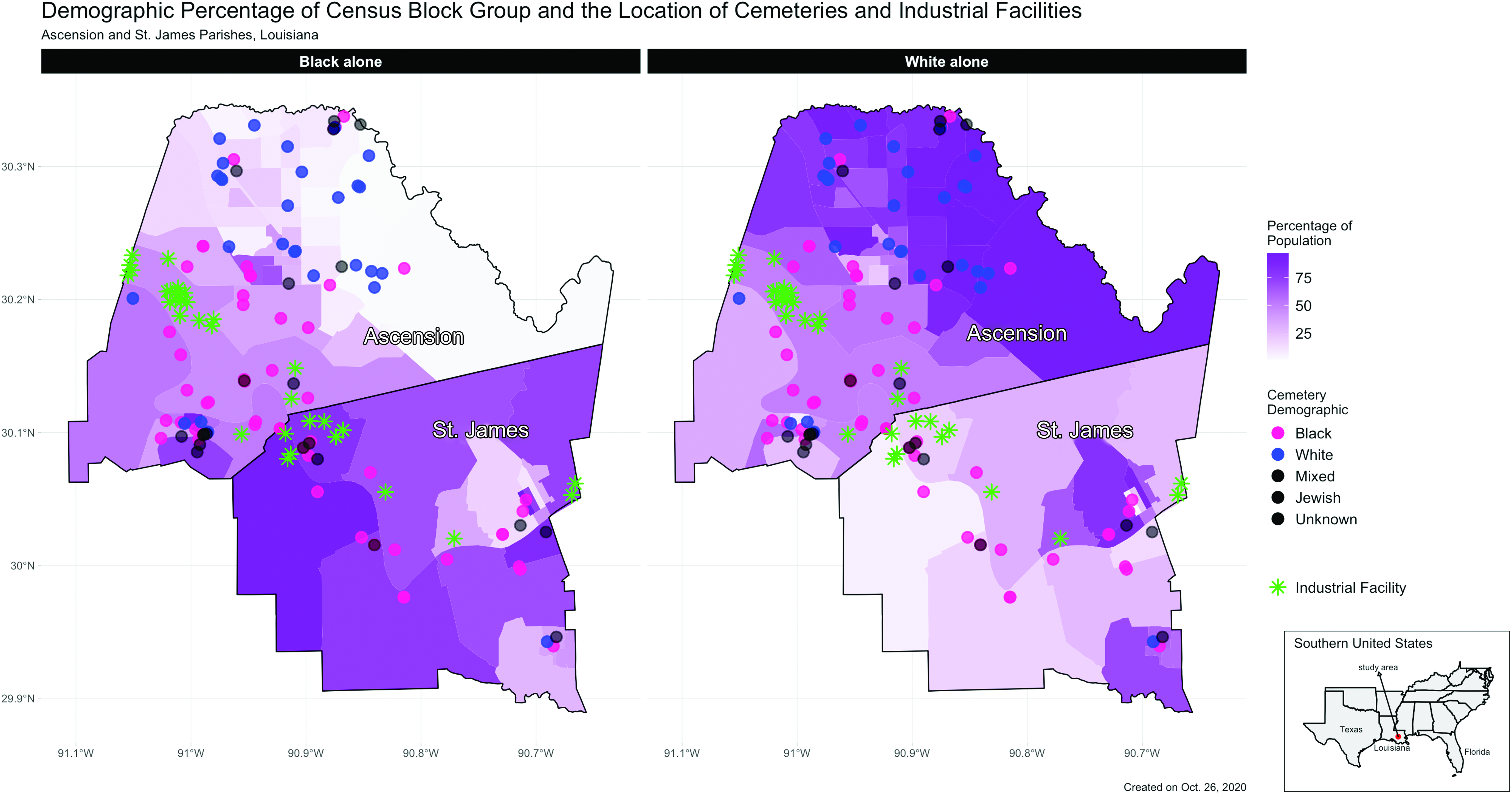
The black alone population and white alone population of Ascension and St. James Parishes. Color images are available online.
Cemetery multihazard exposure to flooding and chemical plants
The map in Figure 6 depicts the intersection of race, flood plains, chemical facility proximity, and cemetery locations in two different parishes. There are 32 chemical plants with 21 located in Ascension Parish and 11 in St. James Parish. Tables 2 and 3 depict 1- and 2-mile exposure zones showing the disparities in cemetery proximity based on the race of those interred. Results by Parish follow.
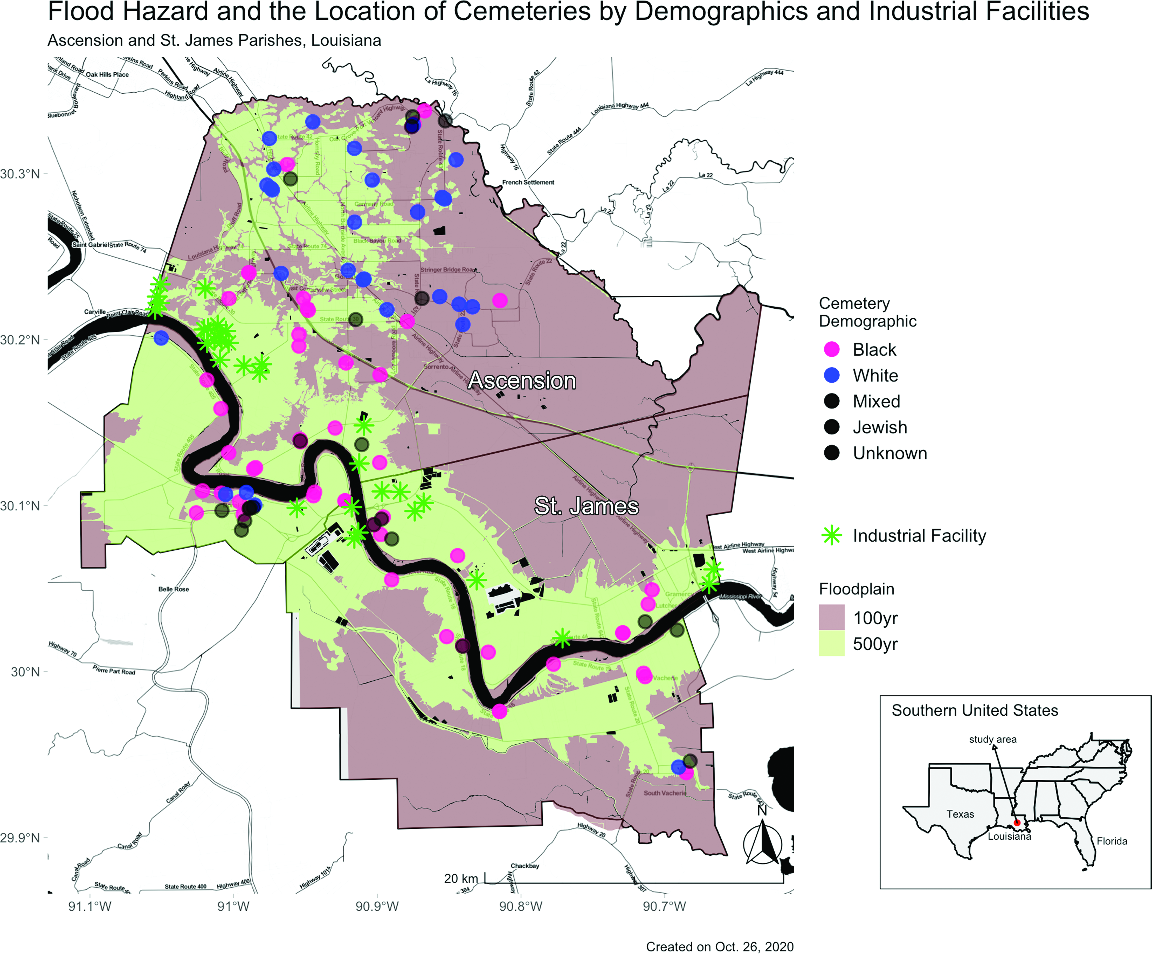
The location of cemeteries by demographics, the location of facilities, and the flood risk. Color images are available online.
Number of Cemeteries with 0, 1, or 2 Industrial Facilities with a 2-Mile Radius of the Center of the Cemetery
Number of Cemeteries Within the 100-Year Floodplain and 500-Year Floodplain in Ascension and St. James Parishes
Ascensions Parish
Chemical facility plants are clustered mostly in the 500-year floodplain in Ascension Parish. There are 20 facilities in the lower risk area (500-year floodplain) and only one facility in the 100-year floodplain. In Ascension Parish, the cemeteries are distributed across both the 100- and 500-year floodplains. There is a total of 73 cemeteries in Ascension Parish, 26 of which are in the 100-year floodplain and 47 in the 500-year floodplain. Ascension Parish has 32 black cemeteries, and of those, nine are in the 100-year floodplain and 23 in the 500-year floodplain. Ascension Parish has 27 white cemeteries, with 14 of those located in the 100-year floodplain and 13 in the 500-year floodplain. Four mixed cemeteries and only one Jewish cemetery is in the 500-year floodplain.
In Ascension Parish, 5 of its 73 cemeteries are located within 2-mile exposure zones containing one or more facilities, as seen in Table 2. The cemeteries near one or more facilities are black cemeteries. Conversely, only one cemetery of the 27 recorded in the Parish contained two facilities within its 2.0-mile exposure zone.
St. James Parish
St. James Parish contains 28 cemeteries. One is in the 100-year flood plain, and 27 are in the 500-year floodplain. All the facilities and most of the cemeteries (27 out of 28) are in the 500-year floodplain. St. James Parish has one black cemetery in the 100-year floodplain and 19 located in the 500-year floodplain. The only white cemetery is in the 500-year flood plain, and four mixed cemeteries are in the 500-year floodplain. Three unknown cemeteries are in the 500-year floodplain.
Of the 28 cemeteries recorded in St. James Parish, 20 are black, and only one is white. The white cemetery has no facilities within its zone, whereas seven black cemeteries have one or more facilities in their 2-mile exposure zones. Of those black cemeteries, two contained one facility in its zone, one with two facilities, two with three facilities, one with four facilities, and one with six facilities in its 2-mile exposure zone. Five out of nine black cemeteries in Ascension Parish are in the 100-year floodplain and are located near one chemical facility. Two black cemeteries are near one chemical facility and are in the 100-year floodplain in St. James Parish. Finally, one black cemetery is located near two chemical plants and is in the 100-year floodplain.
DISCUSSION
When comparing the number of black and white cemeteries with one or more facilities in their 2-mile exposure zone with St. James Parish, the vast racial difference in exposure due to plant proximity is clear because the lone white cemetery had no facilities within its 2-mile exposure zone. Black cemeteries' proximity to chemical facilities decreases cemetery visitors' accessibility to the burial ground, accelerates the grounds' degradation, and fosters disrespect of the interred. Although only three cemeteries are located near two or more chemical facilities, the expansion of existing chemical plants raises concerns about future access to the cemeteries.
In St. James and Ascension Parishes combined, 27% of all the cemeteries are in the 100-year flood plain, whereas only 3% of the facilities are in the same floodplain. Black cemeteries represent 51.5% of those cemeteries. There are fewer black cemeteries than white cemeteries (10 vs. 14) in the 1% annual flood risk. When considering both parishes, about 55% are in a 1% annual flood risk, and about 39% are in a 0.2% annual flood risk. Planners in Ascension and St. James Parish—through zoning and land use plans—have created a context friendly to placing chemical plants in landscapes with the least risk of flooding—along with the natural levee protection. As a result, if cemeteries experience nuisance flooding, they may be inaccessible due to pooling water. Ascension and St. James Parish made >25 disaster declarations in the past 20 years. 67 As climate change increases coastal flooding occurrences, cemeteries in floodplain areas are likely to experience more structural damage.
The implications of the spatial analysis for the future of black cemeteries in the two parishes are significant and should concern disaster mitigation planners, land use planners, and historic preservationists. The maps illustrating spatial distribution indicate that black communities living far from the urban center are at greater flood risk and closer to hazardous plant facilities than most of the white population. There are more black cemeteries in St. James Parish, where residents, descendants, and stakeholders are actively protesting the expansion of the Formosa chemical plant. The black alone population in Ascension Parish is lower in comparison with St. James Parish indicating that migration from other counties may occur to visit the Ascension Parish. A future study can further investigate the migration of the black alone population and the white alone population and understand how this impacts the frequency with which descendants visit and assess conditions of the cemeteries in Ascension and St. James Parish.
These findings should inform the state's disaster mitigation planning, serve as a yardstick for just land use policy, and encourage city planners to integrate historic preservation surveying and mapping into their risk assessments of the cultural landscape (and vice versa). Furthermore, the implications for social cohesion related to cemetery visitation and maintenance require all of this work to be done in a close partnership or as participatory preservation projects with the most vulnerable communities. Local practitioners and residents could conduct future site assessments of the cemeteries to identify needs and flood mitigation strategies with parish planning departments coordinating the effort. For example, a user-friendly survey can enlist descendant communities to identify areas appropriate for proper drainage and sinking depressions in the earth, contributing to flooding the cemetery. The National Park Service has a quick cemetery assessment form with standards for measuring damage in a cemetery, offering insights into how cemetery damage and risks can be documented to serve as a mobile or paper survey model. 68
CONCLUSION
This article, drawing on various efforts to map racially disparate hazard impacts on African American communities and historic sites, addresses plant siting's relationship to mitigation and protection of cemeteries already exposed to flood risk. The authors posit that two factors contributing to cultural resource endangerment—policies that incentivize plant siting in some areas and not others and flood risk—are inextricably linked. These two factors create intersectional (racialized) multihazard impacts on cemeteries. 69 Land use plans and planning cultures that incentivize plant siting near predominately African American settlements and community anchors exacerbate the existing susceptibility to postdisaster impacts such as flooding by inhibiting visitation and ways to protect sites and mitigate harm legally.
Chemical plant siting must not be allowed to place cemeteries at risk by decreasing accessibility to those responsible for their care. Furthermore, we argue that inequitable plant siting introduces access issues, as evidenced by the well-publicized struggle in St. James Parish over residents' cemetery visitation near the proposed Formosa plant site. A lack of access is a dimension of hazard because this condition decreases the likelihood that residents and descendants related to those interred in black cemeteries near plants can regularly perform maintenance or plan to mitigate the impacts of flooding.
Results indicate that more study of the relationships between plant siting and descendants' capacity to mitigate harm to cemeteries is required. The authors mapped >100 cemeteries in two parishes to determine if a spatial relationship existed between black cemeteries and their proximity to multihazards. Spatial analysis shows that the frequency with which black cemeteries are located near one or more chemical plants is greater than that of white cemeteries. All cemeteries in Ascension and St. James Parishes are in the 100-year floodplain, whereas the chemical facilities are in the 500-year floodplain. Population distributions in Ascension Parish indicate that black cemeteries may suffer maintenance neglect due to the black population's living far away from these sites.
Authors argue that future study should correlate to land use policy change, enforcement of existing laws, and planning practice informed by restorative justice. Although legal protections are available to protect cemeteries, they may be unevenly enforced. Louisiana created the Louisiana Historic Cemetery Preservation Program in June 2010. The authors suggest a racial equity audit of the Louisiana Historic Cemetery Preservation Program's oversight be conducted.
Furthermore, the ways that industries are sited near and encroach on cemetery boundaries exacerbate vulnerability due to the state historic preservation regulatory complex's failure to designate African American cultural resources as historically significant. Government-sponsored preservation ironically renders invisible the historical significance of burial grounds, which increases their vulnerability. 70 Frequent hurricanes bring torrential downpours that uproot and dislodge those interred in these burial sites exacerbating their vulnerability to ecological destruction. Industrial encroachment and insufficient regulatory protection of burial sites fueled by racial discrimination sustain perpetual and persistent vulnerability for Cancer Alley's black cemeteries. Database development and documenting the racialized multihazard impact on cemeteries are necessary.
Analysis of findings shows that expanded multilateral study of racialized multihazard exposure is necessary throughout Cancer Alley to provide a detailed risk assessment of the cemeteries, identify other hazards this article did not capture, and buttress organizers' efforts to increase their scope of influence and support. The Texas Freedom Colonies Project's Atlas and Study is an example of how spatial analysis helps illustrate previously unmapped sites' access, vulnerability, and visibility within historic preservation and disaster planning. The Atlas' spatial analysis—indicating whether cemeteries are at risk of flooding or in the path of an infrastructure project—has become part of government agency audits and cultural resource surveys. 71 Surveyors using this free resource can suggest ways to mitigate harm to FC and their cultural assets. The authors argue that Louisiana can learn from this model and allocate funds to cemetery database building and analysis to identify and target resources to address apparent exposures and disparities.
Finally, the authors believe the state should invest funds in grassroots groups of residents who can play an essential role in documenting cemeteries in state historical cemetery databases by engaging in archival research. The resulting data (funeral programs, obituaries, and images) help professionals map missing cemeteries. With the right support, new participatory mapping, and surveying 72 efforts and existing citizen science among advocacy groups can collaborate with state agencies and parish land use planners to help record undocumented cemeteries and include these historically significant sites within buffer zones.
Footnotes
AUTHOR DISCLOSURE STATEMENT
No competing financial interests exist.
FUNDING INFORMATION
There was no funding provided for this research.