
Abstract
Children are uniquely vulnerable to environmental health risks associated with industrial contamination, and early childcare and education (ECE) facilities are important sites for potential exposure to environmental contaminants. Emerging research on historic urban industry has additionally demonstrated that urban environmental risk accumulates historically and spatially across urban landscapes. Accordingly, this study pairs cross-sectional data on licensed childcare facilities with longitudinal manufacturing site data in Providence, Rhode Island. We use these data to investigate the proximity of ECE facilities to active and relic manufacturing sites, controlling for a range of organizational- and tract-level characteristics. Results show that type of childcare facility (center-based vs. in-home) and language of instruction (Spanish vs. English) are important predictors of children's proximity to industrial lands, past and present. These findings indicate that Spanish-speaking children in Providence may experience a “double jeopardy” in the form of disproportionate legacy environmental hazards at ECE as well as at home—suggesting that the historical nature of urban industrial land use is an important mechanism of environmental inequality for young children.
INTRODUCTION
Early childhood is a precarious stage of life, when individuals are especially vulnerable to environmental risks through a variety of exposure pathways. 1 Children's unique vulnerability to environmental health risks means that the consequences of environmental exposure are magnified at younger ages. In the United States, these concerns are compounded by related research showing disproportionate proximity and exposure to pollution among nonwhite and low-income groups—including children—leading to poor health outcomes and widening inequalities that are cumulative across multiple forms of social and environmental disadvantage. 2
One important environmental disadvantage stems from urban environments that are characterized by the historical accumulation of hazardous land uses. 3 The intersection of historical industrial land use with patterns of sociodemographic settlement shows that environmental inequality results from complex socioenvironmental processes and calls for deeper analysis of the “legacy effects” of former industrial sites and infrastructure on urban communities. 4
To investigate the potential effects of historical environmental contamination on children, a first step is to assess children's proximity to potential hazards. To do so, this study pairs cross-sectional data on licensed childcare facilities with longitudinal manufacturing site data in metropolitan Providence, Rhode Island. We use these data to investigate possible relationships between these two types of land use that may inadvertently put young children at an increased risk of exposure to industrial contaminants, controlling for a range of census tract-level sociodemographic characteristics.
Children participating in childcare arrangements may spend as much as 10 hours a day at these facilities, making them important sites for potential exposure to environmental contaminants. 5 In this way, our approach extends the literature on environmental risk in spaces outside of the home, which include schools, 6 industrial workplaces, 7 and farms, 8 while simultaneously building on recent research on the contemporary consequences of historic patterns of urban industrialization and residential segregation. 9
Prior research shows that low-income residents and communities of color in metro Providence live in disproportionate proximity to a range of environmental hazards and enjoy fewer environmental benefits 10 ; this article builds on existing environmental justice research to consider whether these local patterns are replicated in relation to childcare establishments. Results indicate that type of childcare facility (center-based vs. in-home) and language of instruction (Spanish vs. English) are important predictors of early childcare and education (ECE) proximity to current and historical industrial land use and pollution.
Our findings have implications for how researchers study children's environmental health risk and how local governments protect children from undue harms associated with industrial activities. Locally, this article contributes to ongoing efforts by the Rhode Island Departments of Health and Environmental Management to mitigate the risk of childhood exposure to environmental hazards—including through the Rhode Island Childhood Lead Poisoning Prevention (CLPP) and ATSDR Partnership to Promote Local Efforts to Reduce Environmental Exposure (APPLETREE) Programs—by measuring the social segmentation of proximity to an extensive set of active and former or “relic” hazardous manufacturing sites.
Environmental risk in ECE
Scholarly research of relevance to environmental risk in ECE generally falls into three categories, each differentiated by spatial scale and unit of analysis. One approach focuses on individuals' exposure to environmental toxins during childhood, and reveals that a variety of biological, physical, and social factors contribute to children's susceptibility to environmental contaminants. 11 For example, the rapid pace of early childhood development means that children's bodies are more vulnerable to chemical and radiological contamination even as children are more likely to engage in behaviors that put them in contact with hazardous spaces and substances. 12
Even more, the impacts to childhood health reverberate across the life course, as early childhood development conditions are pathways to adult health 13 that have a measurable impact on health and socioeconomic mobility later in life. 14 Thus, poor childhood health for socially vulnerable children has the unique capacity to magnify various forms of inequality and disadvantage across the life course. 15
A second approach focuses on the built environment rather than people, measuring environmental health burdens present in the physical spaces of homes, childcare facilities, and schools. Here, we learn that ECE represents a significant exposure pathway for a variety of environmental toxins, including flame retardants, 16 phthalates, 17 formaldehyde and acetaldehyde, 18 volatile organic compounds (VOCs), 19 and per- and polyfluoroalkyl substances (PFAS), 20 as well as lead, a long-term focus of children's environmental health research. 21 As we describe in subsequent sections, heavy metals, VOCs, and PFAS were important byproducts of Providence-area manufacturing and represent ongoing contaminant concerns today.
The third approach scales up the level of analysis from homes and workplaces to communities by examining inequalities in neighborhood-level proximity to potential sources of environmental exposure risk. Studies demonstrate that K-12 school siting represents a key mechanism for the perpetuation of environmental inequality, with low-income students and students of color generally attending school in communities with larger numbers of nearby environmental hazards than students who attend schools in wealthier neighborhoods. 22
Not only this, but also environmental risk tied to school siting is itself a mechanism that produces segregated schools and neighborhoods, suggesting that the relationship between inequality and environmental toxins is bidirectional. 23 Our work aims at testing the hypothesis that similar patterns extend to the childcare and preschool environment.
In addition, although researchers have not directly introduced language of instruction as a variable in school-to-hazard proximity research, environmental justice literature generally finds that Spanish speakers and those with limited English proficiency face comparatively greater environmental burdens and enjoy comparatively fewer environmental benefits. 24 These effects may be magnified through the intersection of language with race, ethnicity, immigration status, and other sociodemographic variables. 25 The present study extends this work to consider the role of instruction language in ECE-to-hazard proximity.
Together, the three approaches reveal important potential links between childhood health and exposure risk, the built environment, and social–environmental inequality. The present study adds to the emerging literature on the impact of legacy industrial contaminants and childhood environmental inequality. Enabled by new computational approaches for identifying historical industrial land use, 26 we investigate the spatial proximity of current Providence-area ECE providers to active and relic manufacturing sites as they have accumulated spatially in the city over the past 70 years. These novel longitudinal data allow us to use the full scope of neighborhood-level industrial history to examine environmental risk in early childhood education.
Historical, geographical, and regulatory context
Metro Providence is layered in a centuries-long history of industrial production and a legacy of pollution stemming from those activities. Like other deindustrializing cities in New England and elsewhere, Providence-area residential and industrial geographies are linked through the economic and environmental history of regional industrial development, historical practices of racialized home credit policies that served to fix residential segregation in place, and local zoning, tax structures, and development practices that ensured the continuation of unequal racial-environmental geographies. 27 These are joined by historical process of land use change that saw former industrial sites demolished or converted for other uses, in many cases hiding years of toxic accumulation beneath a non-industrial veneer. 28
Through the mid-20th century, Providence's economy was largely industrial and dominated by textile, machine tool, and plate jewelry manufacturing, which introduced environmentally persistent contaminants into local soils and water. Contaminants included heavy metals such as lead, mercury, and cadmium used in electroplating and machining; VOCs, such as trichloroethylene; long-chain PFAS, particularly those used in textile industries; and polychlorinated biphenols and polycyclic aromatic hydrocarbons common to all industrial production. Exposure to these and other contaminants pose documented outdoor and indoor health risks for children, including immunological and neurological effects, 29 pulmonary infection and decreased respiratory function, 30 and increased cancer risk. 31
Dozens of large mill complexes and hundreds of smaller factories spread throughout the city, but they tended to cluster along the floodplains of the Providence and Woonasquatucket Rivers. 32 Additional industry clustered along the Blackstone River through Pawtucket, Central Falls, and Woonsocket. Worker housing also concentrated in these areas and, by the 1930s, now-familiar patterns of residential segregation took shape, aided by the production of mortgage lending maps by the Home Owners Loan Corporation (HOLC), which banks and lenders used to deny federal mortgage benefits to residents of neighborhoods labeled as “declining” or “risky”—labels that primarily reflected the racial composition of an area at the time that it was assessed by HOLC cartographers. 33
Industrial decline began in the 1960s, triggering a broad shift in sociodemographic settlement patterns that saw white residents follow remaining industrial jobs to the suburbs—a pattern repeated in Boston, 50 miles to the north, and other industrial cities around the country. 34 In the process, Black neighborhoods located in the old industrial core gradually diffused across the city, bolstered by new immigrants from Cape Verde, Western Africa, and the Caribbean. 35 Starting in the 1980s, metro Providence also saw a large influx of new Latinx residents arriving from Puerto Rico, the Dominican Republic, Guatemala, Colombia, and Mexico (Fig. 1). 36

Black and Latinx population, 1970–2010, using 2010-equivalent tract boundaries. Truncated to 1970 to match data availability for Latinx variable. Data source: Longitudinal Tract Data Base (
Marlow et al. (2020) document this dual transition: As neighborhood disinvestment followed deindustrialization, Black and Latinx residents, especially newer immigrants, settled near former and current areas of concentrated manufacturing, where real estate costs were lower, setting the stage for the present study. 37
Today, Providence is a majority-Black, Indigenous, and People of Color (BIPOC) city characterized by deep economic inequality and high levels of neighborhood-level segregation, with the fifth highest level of income inequality of any large U.S. city. 38 Child poverty rates in Rhode Island's densely populated urban core are more than double the rest of the state 39 ; communities of color are disproportionately poor and, as Marlow et al. (2020) also demonstrate, reside disproportionately close to potentially contaminated sites of current and relic manufacturing. 40
The confluence of the historical processes of deindustrialization, in-migration and settlement of a large immigrant population, and ongoing neighborhood racial and ethnic segregation—alongside the specific history of Providence-area industrial contamination—has raised concerns among childcare advocates and government agencies about how patterns of uneven settlement and environmental risk impact children who attend childcare and preschool in the area.
As Figure 2 shows, ECEs and manufacturing sites exhibit different, yet overlapping, spatial patterns. Although relic industrial sites cluster in the old urban industrial core adjacent to the city's small downtown and financial district and along its two main rivers, active manufacturing facilities are fewer in number and less concentrated, tending instead to diffuse along highways and in suburban industrial parks in neighborhoods. ECEs tend to concentrate in the dense residential neighborhoods west and south of downtown. A closer look at ECE point locations also reveals important differences in the street-level structure of the Providence area childcare system. Home-based childcare facilities are generally located in the interior of residential districts, often two or more blocks from commercial thoroughfares.

Kernel density estimate for ECE facilities and active and relic manufacturing sites in metro Providence, RI study area. Density estimates are presented unscaled to emphasize the high density of relic manufacturing sites centered on the historical urban core cities of Providence, Pawtucket, and Central Falls. Asterisk marks downtown Providence. Data source: Longitudinal Manufacturing Database for Rhode Island (Marlow and Frickel 2018). ECE, early childcare and education.
Although they are less numerous and more dispersed, center-based childcare facilities and preschools rarely lie further than a block from commercial streets where manufacturing activities were and are often located. The result is that home-based childcare facilities, on average, are located further from active and relic manufacturing sites than the average childcare center, as Figure 3 demonstrates. Figure 3 also suggests that childcare facilities of both types (center- and home-based) overlap substantially with the historical geography of former industry: The median distance between childcare facilities and the nearest relic manufacturing site is just more than 400 feet, about half the corresponding median distance to nearby active industry.
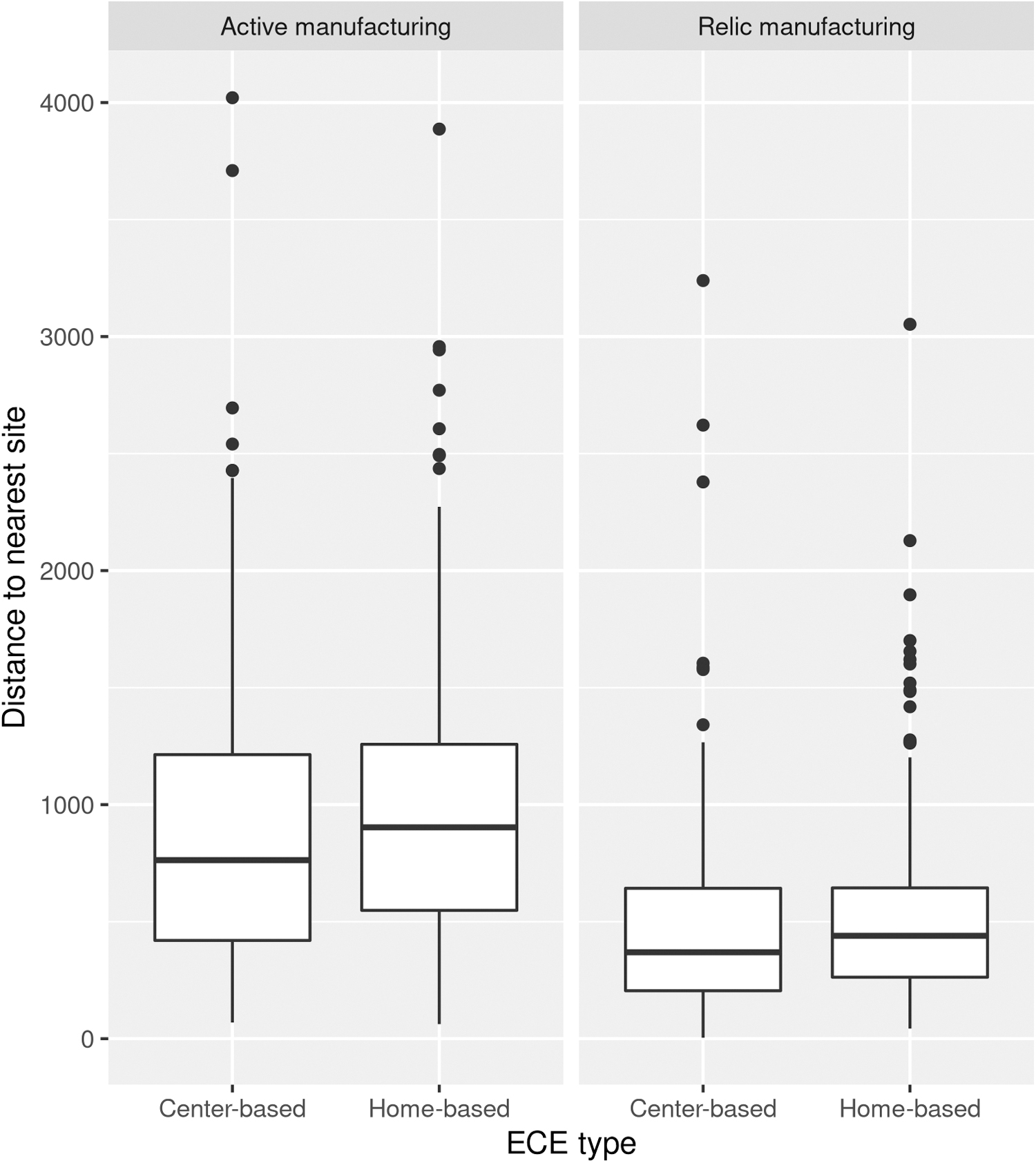
Distribution of distances to nearest active and relic manufacturing sites for center- and home-based childcare facilities.
Center-based and home-based ECEs are also subject to different regulatory and licensing structures. Childcare centers, which enroll a larger number of children per site and thus comprise a greater number of childcare slots overall, are generally assessed for architectural compliance. Center-based care providers submit floor plans for approval by the Rhode Island Department of Human Services (RI DHS) with the support of a licensed architect provided by the Rhode Island Child Care and Early Learning Facilities Fund (RICCELF). In contrast, home-based licensure seeks to ensure that providers receive basic health, safety, and business training, and applicants attend several orientations and trainings covering requirements for initial licensure and renewal, health and safety, and small business management.
Except for ensuring that center-based and home-based care providers have up-to-date documentation of lead, radon, and water quality results, Rhode Island ECE licensure does not currently evaluate potential site-based contamination. This is changing, however: Through the Choose Safe Places for Early Care and Education (CSPECE) program, Rhode Island Department of Health (RIDOH) staff will partner with RI DHS, RICCELF, and the Center for Early Learning Professionals to incorporate education about and consideration of environmental health hazards into the pre-licensure process.
DATA AND METHODS
Following U.S. Census guidelines for tract-level urban/rural designations, our analysis targets central Providence and includes all neighboring census tracts with population densities >999 people per square mile. 41 This approach defines our study area as including the contiguous cities of Providence, North Providence, Pawtucket, and Central Falls and parts of the suburban cities of Cranston, Johnston, and Warwick. In all, this region covers 97 densely populated census tracts that define the Rhode Island capital region (tract boundaries shown in Fig. 1). Configuring our sample in this way minimizes variation in the size of the spatial units under examination while also providing a way to meaningfully assess variation at multiple levels of analysis, as we describe next. 42
ECE data are drawn from RI DHS and include every licensed ECE provider registered with the State of Rhode Island, including licensed home-based childcare facilities. 43 ECE data include information on provider type and language of instruction, allowing us to compare home-based providers with larger childcare centers and Spanish-language facilities to English-language ones. 44 All of the ECE sites in this study are licensed by the State of Rhode Island—though, as noted earlier, center-based and in-home childcare providers are subject to different licensing structures. It is notable that all Spanish language childcare facilities are home-based; there are no Spanish language childcare centers in the data set.
Longitudinal manufacturing site data are drawn from historical issues of the Rhode Island Directory of Manufacturers and span the years 1953–2012. 45 Manufacturing data were extracted using optical character recognition and a novel computational pipeline. 46 For each directory year the data set contains every listed facility, including the company name, street name and number, city, zip-code, the number of employees, and the two-digit standard industrial code.
Following Elliott and Frickel, 47 manufacturing sites were geocoded based on facility address, excluding all post office box addresses to limit the inclusion of company headquarters where no manufacturing took place. The full dataset contains information on nearly 12,000 unique industrial manufacturing sites and more than 34,000 site-years of data spanning nearly six decades. 48
For this study, we coded facilities that closed before 2010 as former or “relic” sites, 2980 of which are located within the study area and represent potential sources of legacy contaminants sequestered in surface and subsurface soils and groundwater. The remaining 686 operating manufacturing facilities are coded as sites that were active during the last years of the longitudinal industrial site dataset (2010–2012), matching the decennial census data from the same year. These form the “active” industrial site data that we analyze in subsequent sections.
Because manufacturing site data is truncated to 2012, however, we cannot verify that these sites remain active today. These recently active sites may represent point sources of current pollution risk, including potential exposure to airborne toxins. Both relic and active manufacturing sites overlap with the spatial distribution of ECE facilities, as noted.
We also draw on sociodemographic data from the 2010 decennial US census and the 5-year American Community Survey (ACS) sample estimates for information about the neighborhoods that host ECEs (Table 1). Linking tract-level residential data with ECE site locations is important because research shows that parents generally utilize childcare facilities that are close to home or otherwise conveniently located. 49 This approach also allows us to distinguish between the effects of childcare characteristics, including language of instruction and facility type, and characteristics of the surrounding neighborhood.
Variable Descriptions and Descriptive Statistics
ACS, American Community Survey; RIDOH, Rhode Island Department of Health; SD, standard deviation.
Measuring proximity and estimating inequality
We use a 350-foot radius, or approximately the length of one U.S. city block, to measure overlap between ECE sites and manufacturing sites—a distance measure that falls toward the shorter end of standard proximity analyses. 50 We selected a smaller buffer area because of the small-scale nature of the manufacturing operations in question; unlike industries tracked by the EPA's Toxic Release Inventory (TRI), a spatial database commonly used in proximity-based environmental inequality research, the manufacturing database employed in this study includes smaller establishments that are waived from TRI reporting requirements.
ECEs are linked to census tracts by intersecting the same 350-foot ECE buffer with tract boundaries and selecting the census tract with the largest share of the buffer area. This approach produced consistent results: On average, ECEs are linked to tracts that make up more than 90% of the selection buffer area.
Tract-level spatial distribution of ECEs and active and relic manufacturing sites exhibit high group-wise spatial autocorrelation, with Moran's-I statistics of 0.46 (p < 0.001), 0.13 (p < 0.01), and 0.10 (p < 0.05), respectively. Tract-level sociodemographic data are similarly autocorrelated, with Moran's-I measures for percent Black (0.54), percent Latinx (0.69), and median income (0.33) (p < 0.001 for all). To control for spatial clustering within the data, we estimate the probability of an ECE buffer containing at least one active or relic manufacturing site by constructing a series of logistic regression models, using a Bayesian conditional autoregressive model estimated with the
At the first level of the model, we estimate the effects of organizational characteristics, including language of instruction and childcare type; the second level introduces information about the neighborhoods surrounding childcare sites, drawing on a variety of tract-level sociodemographic variables. Hierarchical modeling allows us to control for heterogeneity across census tracts and to link our relatively sparse ECE location data with detailed census records on those facilities' host neighborhoods. 52 It also allows us to account for the underlying spatial structure of tract-level sociodemographic data by introducing a spatial term (Rho) to account for dependence between neighboring census tracts, defined as tracts that share a common border or vertex. 53
Below, we estimate a series of models predicting the presence of nearby manufacturing facilities, calculated separately for active and relic manufacturing sites, in which ECE sites are considered “at risk” if they include at least one manufacturing site within a 350-foot radius. Nearly half of the ECEs in the study area share a block with one or more manufacturing sites, active or relic.
RESULTS
We begin with a series of two hierarchical models predicting ECE site proximity to active manufacturing sites, followed by a similar analysis predicting proximity to relic manufacturing sites. For each analysis, Model 1 predicts proximity to active/relic manufacturing using organization-level covariates alone; Model 2 introduces tract-level race, ethnicity, income, and education variables as well as several tract-level housing controls. Our interpretations of active and relic manufacturing proximity focus mainly on the full model, Model 2.
Table 2 summarizes the results of our analysis of ECE proximity to active manufacturing sites. Overall, proximity to such sites emerges as a function of the built environment and the spatial organization of ECE sites within their host neighborhoods. Although language of instruction is not a significant predictor of children's proximity to active manufacturing sites, ECE type is. More specifically, children attending home-based childcare facilities are significantly less likely to be proximate to active manufacturing sites than children at center-based childcare facilities and preschools—a robust outcome that remains significant at p < 0.05 even as sociodemographic and housing-stock controls are introduced in Model 2.
Hierarchical Models Predicting the Presence of Active Manufacturing Sites Within One Block of Providence Early Childcare and Education Facilities
p < 0.10, **p < 0.05, and ***p < 0.01, two-tailed test. 95% CI in parentheses.
CI, confidence interval; ECE, early childcare and education.
In the full model, ECEs in proximity to active manufacturing sites are also more likely to be located in neighborhoods characterized by lower population densities, lower college-level education, and higher vacancy rates. Conversely, tract composition by race, ethnicity, median household income, and percent renting are not significant predictors of childcare proximity to active manufacturing.
Table 3 summarizes a parallel analysis for ECE proximity to relic manufacturing sites and shows how proximity to historical industrial sites differs from active industry. In this analysis, ECE proximity to relic manufacturing sites is predicted by language of instruction. Spanish language childcare facilities are more likely than their English language equivalents to be located on blocks once occupied by manufacturing facilities that have since closed. This remains the case across both models, even after controlling for key neighborhood sociodemographic characteristics. Once again, tract-level race and ethnicity measures are not significant predictors of childcare site-level proximity.
Hierarchical Models Predicting the Presence of Relic Manufacturing Sites Within One Block of Providence Early Childcare and Education Facilities
p < 0.10, **p < 0.05, and ***p < 0.01, two-tailed test. 95% CI in parentheses.
In contrast with the models predicting active manufacturing proximity, vacancy rates and population density are not significantly associated with relic manufacturing. Rather, proximity to relic sites is primarily related to organizational covariates, with ECE centers and Spanish language childcare facilities significantly more likely to be in close proximity to these sites of relic manufacturing. Tract-level results suggest that neighborhoods with fewer college-educated residents are the most likely hosts for at-risk ECEs.
Across both models, center-based childcare facilities predict proximity to active and relic manufacturing sites, whereas language of instruction predicts proximity to relic sites only. We believe these findings are conditioned by two underlying factors. First, home-based childcare facilities are concentrated within the interiors of residential areas and thus remain in some ways distant from transportation corridors zoned for commercial and industrial activities.
The opposite is true for childcare centers, which are far more likely to be located, like manufacturing establishments, along heavily trafficked commercial streets. Measuring differences in proximity at the level of individual childcare facilities thus brings into focus a form of environmental risk that is organized street-wise (and so linearly), as an unintended consequence of municipal zoning rules that place many young children on or near industrial lots and on streets characterized by lower air quality from heavy traffic flow.
Second, as previous research has shown, 54 Latinx residents in Providence—and especially the city's growing immigrant population—are concentrated south and west of downtown in neighborhoods characterized by higher densities of relic manufacturing. This may offer a possible explanation for the high rates of relic manufacturing proximity associated with the city's in-home Spanish language childcare facilities.
CONCLUSION
This article holds two important lessons for the study of children's potential exposure to environmental risk at childcare facilities in Providence, the post-industrial Northeast, and in U.S. cities more generally. The first lesson pinpoints the value of bringing longitudinal data to investigations of contemporary forms of injustice and inequality. As prior studies demonstrate, urban industrial risks not only accumulate over time but also diffuse unevenly.
This means that the distribution of relic manufacturing sites will differ from active sites because the spatial organization of industry changes over time, transforming parcels, blocks, and neighborhoods in its wake: Some areas remain in long-term industrial use whereas others are abandoned or redeveloped, at times hiding prior industrial uses from view. 55 This temporal transformation of urban industrial land potentially introduces new generations of city residents to earlier generations of industrial wastes, with uniquely dangerous consequences for young children. The nature of those risks is specific to the historical development and political character of each city.
In Providence, Black and Latinx residents experience disproportionate proximity to these industrial leftovers, but in different ways: Where Black residents are disproportionately exposed to active manufacturing, Latinx residents are more likely to live near relic manufacturing sites. 56 Our analysis shows that the historical nature of cities can impact children unequally as well, insofar as Spanish-speaking children in the Providence area may experience a “double jeopardy” in the form of disproportionate risk at their childcare location in addition to the unequal risk they experience at home.
Even though tract-level income is not itself a significant predictor of ECE-level risk, racial and economic geographies are tightly linked, with Black and Latinx poverty rates (28% and 29%, respectively) nearly double that of white Providence residents (17%). 57
The reasons for this are twofold. First, as noted earlier, a confluence of historical factors systemically excluded Black and, later, Latinx neighborhoods from access to wealth in the form of home equity; at the same time, white flight and deindustrialization transferred employment, wealth, and regional investment to the growing suburbs. In this way, low-income populations and communities of color were confined to polluted neighborhoods marked by persistent disinvestment—a spatial pattern that has proven remarkably consistent over time.
Because patterns of lopsided urban development leading to segregated geographies and unequal environmental outcomes are documented in many U.S. cities, we expect that patterns similar to those uncovered in this study are also characteristic of other postindustrial cities. The computational industrial site identification and multilevel statistical modeling approach developed here will be useful for testing this hypothesis in future research.
The second lesson pertains to how we study the mechanisms that produce unequal outcomes. Results from this study suggest that environmental justice and inequality scholarship would benefit from paying close attention to language—one axis of the “triple segregation” that shapes the experiences and outcomes of Latinx youth 58 alongside race/ethnicity and poverty. Environmental justice research in the United States rarely considers language a distinct mechanism of inequality and segregation, instead considering it a micro-scale signal of other sociodemographic variables. 59
Our results show significant differences by language net of neighborhood-level sociodemographic characteristics, but we are limited by a lack of information on the race, ethnicity, immigration status, or economic class of ECE clients. Our ECE-level results may, therefore, capture several distinct predictors of ECE-level environmental inequality simultaneously. However, as the longstanding focus on language and linguistic segregation by educators and education researchers attests, 60 language itself is an important factor when studying preschools and childcare facilities, where language of instruction is one of several key policy levers, alongside cost and access, that shapes how and where children learn.
Reflecting the relative success of environmental justice scholarship and social movements, state and federal regulators have gradually turned their attention to site- and proximity-based sources of childhood environmental risk, and childcare siting increasingly considers the current and former uses of adjacent property parcels. 61 However, environmental risk is poorly understood, and small-scale and legacy industries are rarely considered by environmental regulators due to their ubiquity and the challenges of efficiently and effectively identifying them. 62
Accordingly, this study has sought to update child-focused environmental inequality research to match new understandings of the accumulation of urban industrial pollution, using variables relevant to policymakers and researchers concerned with environmental risk in early childhood education. We hope that our findings at least demonstrate the potential scale of the problem. Specifically, environmental risk in early childhood education is likely linked through specific sites to a longer, more complicated history of urban industrial development, and language and associated factors such as immigration status may be important mechanisms of environmental inequality at the level of individual blocks and property parcels. Future research would do well to examine specific exposure pathways to legacy and recently active manufacturing contamination, as it may impact childcare settings.
Footnotes
AUTHOR DISCLOSURE STATEMENT
No competing financial interests exist.
FUNDING INFORMATION
We acknowledge support from the Agency for Toxic Substances and Disease Registry through an APPLETREE cooperative agreement program grant, NU61TS000315-01-00; and from the Superfund Research Program of the NIEHS, grants P42ES013660 and 3P42ES013660-14S1. Thomas Marlow supported by the NYUAD Center for Interacting Urban Networks (CITIES), funded by Tamkeen under the NYUAD Research Institute Award CG001.