
Abstract
On the Gulf Coast of Texas, a large disparity exists between the number of homes still in need of repair after Hurricane Harvey and the number of homes actually repaired by the City of Houston in previously segregated neighborhoods. Seven years after the storm, the authors conducted oral history research through the lens of environmental justice with a focus on the most vulnerable homes in neighborhoods facing displacement, with senior owners struggling to age in place. This article presents the findings from one oral history data set representative of reoccurring themes in qualitative and quantitative research. The data reveal that residential ecological knowledge and citizen participation have been ignored over extended periods of time, exacerbating storm damage, displacement, and environmental policy failures.
INTRODUCTION
Hurricane Harvey hit Houston, Texas, in August 2017, during the hurricane season, and left behind compounded devastation in neighborhoods that have historically been the most impacted by natural disasters and environmental injustice. Within city limits, Harvey damaged 208,000 single-family homes, primarily through flooding. 1 Of these homes, 61,359 were owned by seniors, and 49.6% (103,451 households) earned at or below 80% of the median income for Houston and Texas. Families without savings and seniors with fixed incomes, without home and flood insurance, were left teetering on the brink of permanent homelessness, threatening their lifelong investment and quality of life. The post-disaster landscape uniquely and inequitably burdens African American 2 seniors who are aging in place 3 in neighborhoods that have been historically segregated, disinvested, and reterritorialized 4 through gentrification.
Aging in place is a guiding strategy recognized to address and meet the needs of older people. An American Association of Retired Persons (AARP) study showed that the majority of older people want to age in place, remaining autonomous, active, and independent as long as possible while surrounded by family and friends. Iecovich defines aging in place and the conditions needed to enable it as multidimensional. Place, which in this synthesis is referred to as house and community, holds a physical dimension, a social dimension, and a cultural dimension. 5 Aging in place is preferable from both the perspective of the older person and policymakers. While older people prefer to stay in their homes because it enables them to keep their identity and maintain their well-being, policymakers find that the cost of institutional care is much higher than providing community care in an individual’s home. Aging in place has many proven benefits, whereas relocation results in negative impacts such as loss of social relationships, changes in routine and lifestyle, and loss of independence and personal belongings. 6 This can be identified in areas that are undergoing gentrification and revitalization, which occur post major storm events.
On the scale of displacement post Katrina, researchers reported in 2009, existing residents were granted the right to block the placement of a Federal Emergency Management Agency (FEMA) Katrina Cottage program. 7 As a result of Gulfport and surrounding municipalities’ exclusionary responses, all but 3000 families received new homes in the Katrina Cottages program. At one time, FEMA identified 14,000 households that were eligible for the program out of an estimated 50,000 damaged homes, and 49,000 FEMA trailers deployed. 8 Although architecturally designed to withstand future hurricanes and designed to aesthetically match the area, the temporary-to-permanent housing solution was derailed.
Another post-Hurricane Katrina study investigated the right to adequate housing, health, and dignity, and concluded that the Housing Authority of New Orleans (HANO) failed to protect fundamental human rights through discriminatory policies that included demolished still-viable housing units, serial displacement, placation, and intimidation of residents. 9 Gardner, the Director of the Human Right to Housing Program at the National Economic and Social Rights Initiative, worked with two researchers from the Harvard School of Public Health to also connect the health outcomes associated with HANO’s poor housing response. They found that the most impacted populations were women, children, and the elderly. One elderly Section 8 resident was repeatedly forced to move because of poor housing conditions and a lack of repairs after her first residence was demolished. During her interview, she described the feeling of having moved for the eighth time: “Ever since Katrina, I haven’t been feeling well. I’m so worried about finding a stable place to live.” 10 She was hospitalized during the process for diabetes, hypertension, and heart complications.
The problem with trailers during the displacement process has been well researched by Bullard and Wright. 11 In fact, when individuals experienced various health issues and complained to the relief agency, they were ignored. These symptoms compound in seniors who experience eye, nose, and throat irritation; nausea; skin rashes; sinus infections; depression; asthma attacks; headaches; insomnia; memory impairment; and difficulty breathing. 12 The Sierra Club tested 31 trailers and found that 83% of them had levels of formaldehyde above the EPA limit of 0.10 parts per million. 13 After testing results were made available, FEMA discontinued distributing the trailers because of high levels of formaldehyde and later admitted responding too slowly. The Centers for Disease Control (CDC) tested and found hazardous levels of formaldehyde in 519 trailers. The CDC tests indicated formaldehyde levels were 75 times the U.S.-recommended workplace threshold. Formaldehyde is a known carcinogen with serious health effects with exposure. The average level found in the CDC test was 77 parts per billion (ppb), and the average in a newly constructed home is 10–20 ppb. The highest level recorded was 590 ppb. An estimated 195,000 people were living in trailers 2 years after the storm. 14 This indicates a need for not only improved indoor air quality from an architectural perspective but also oversight during the recovery process and a need to reduce or eliminate the time families spend in low-quality temporary housing.
In a recent study following Hurricane Harvey, researchers found that the presence of children in the home and the absence of a disabled person in the home were predictors of greater household recovery. 15 Of the 439 respondents who took the survey, the median age was 49, and 17% identified as non-Hispanic Black. Results concluded that U.S.-born Hispanics had 350% greater odds of receiving assistance from any source. 16 In another study, Rivera raises the point that children and seniors are sometimes dependent on other disaster victims to recover during short-term periods post-disaster. 17 His study focuses on the impact of social vulnerability measures on residents’ ability to prepare, respond, and recover, and he draws his data from the Kaiser Family Foundation and the Episcopal Health Foundation telephone surveys of 798 respondents post-Hurricane Harvey. 18 The researcher begins to discover that repeated storm events might in some way increase the ability of the individuals to recover due to familiarity with the process, along with indicators such as not having to evacuate. Higher levels of home damage and damaged vehicles reduce one’s ability to recover, according to the research.
Environmental justice, disaster recovery policy, and the built environment
This synthesis explores the threads of racial bias that disenfranchise historically segregated communities of color in the Gulf Coast region of the United States, specifically those occurring post-disaster. Recurring systemic patterns of housing inequity are compounded and exacerbated during hurricane seasons and cycles in the Gulf Coast region, revealing that inadequate severe weather housing recovery policies throughout time negatively impacted the health of neighborhoods and families.19,20,21 In addition, post-disaster research on New Orleans after Hurricane Katrina by revealed that vulnerable populations received inadequate recovery responses rooted in systemic racism.22,23 Environmental justice research expands our understanding of why non-White populations are already at a disadvantage in recovering equitably from storm events, even before damage to their home. Research on Hurricane Katrina suggests that disaster recovery policies may improve if they incorporate environmental and ecological planning approaches that integrate vulnerable populations, resource management, indoor environmental quality, and participatory planning.24,25,26
Study area: Independence Heights, Houston
Originally developed by freedmen and women in 1915 as the first African American city in Texas, Independence Heights (Fig. 1), referred to by longtime residents as Studewood, is designated in the National Register of Historic Places for its significance in community planning and development. Ironically, Independence Heights dissolved its status to be annexed into the City of Houston in 1929 in the hope of receiving basic city services and infrastructure that they still lack today. The U.S. Geological Survey maps (USGS) from 1915 and 1947 show that Independence Heights roads were originally laid out on dirt roads, 27 which were accessed by Houston Streetcars on the Studewood line, which stopped at the 30th Street, the entry point to the neighborhood. The National Registry describes a rapidly growing self-sufficient, skilled, and resilient community, “most of the houses were built by residents of Independence Heights who were contractors, carpenters, brick layers, and electricians.” 28
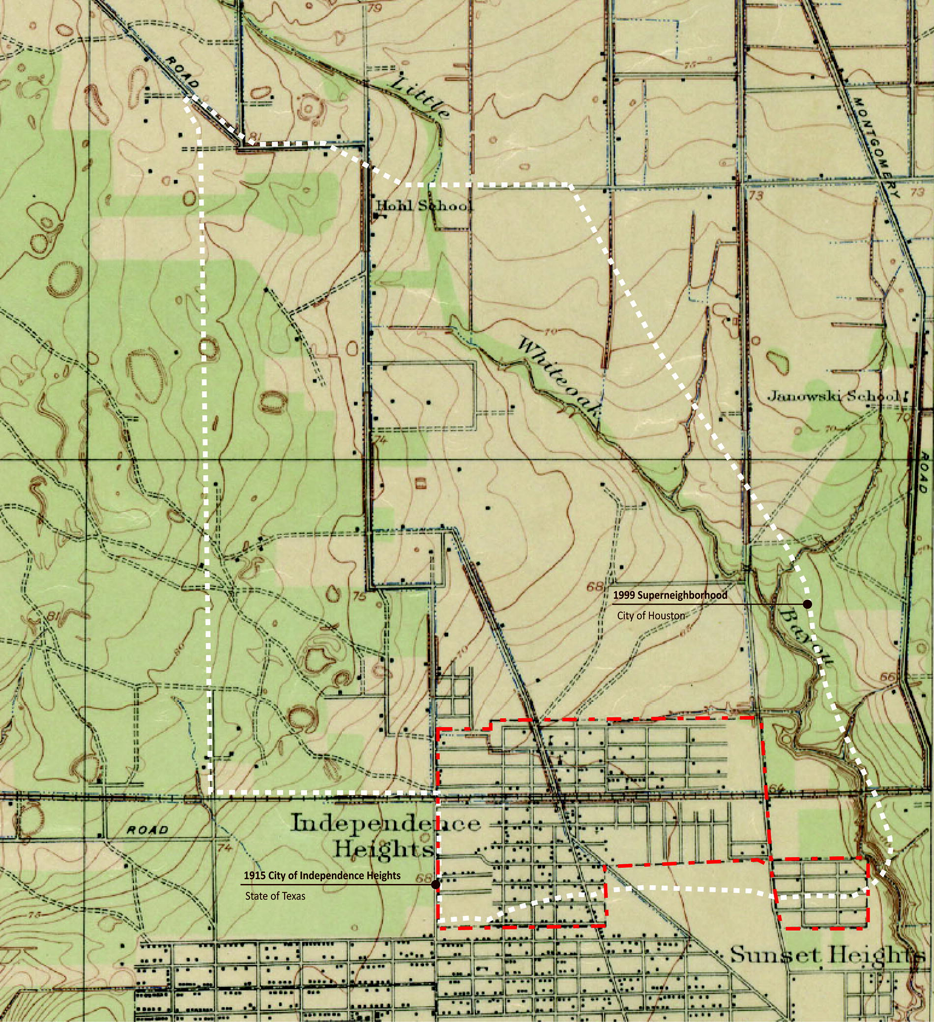
Historic 1915 City of Independence Heights and 1999 super neighborhood of Independence Heights Boundary Overlays.
Independence Heights is in the White Oak Bayou watershed, originally surrounded by nature and an undeveloped piney wood forest to the north and northwest (Fig. 2). All topographies, White Oak Bayou, and stream networks flowed southeast toward Little White Oak Bayou and Buffalo Bayou. The 1920 census reported 720 people living in the community, at the northern edge of the City of Houston, with water frontage along Little White Oak Bayou, establishing “better living conditions and environment than the typical Ward neighborhoods.” 29 Today, the census tract 48201530300 (5303) follows the original boundary and has 2358 residents. Houston expanded the Independence Heights boundary as a super neighborhood to include 14,314 people in 3.4 square miles, with four census tracts and 5623 housing units (Fig. 3). The land areas in the 100-year floodplain, 500-year floodplain, and floodway are 56% of the super neighborhood (Fig. 4). Within the flood risk zones, 75% of the neighborhood population have established residences. This includes 85% of all non-White neighborhood seniors. Of those seniors, 44% lived below the poverty level.

GIS Map of City of Houston and super neighborhood 13 boundaries. NTAD_Raillines,  Major Rivers_Houston,
  FEMA Floodplains_2015,
  Parks_City_of_Houston,
  SuperNeighborhood 13,
  CityHoustonBoundary.

Independence Heights and the Gulf Coast Ecological Bayou System.

Oral History Hot Spot Map, Independence Heights, Houston, Texas.
The study area, census tract 5303, was mapped using the Climate and Economic Justice40 Screening Tool (Justice40) and was identified as disadvantaged in all seven categories: Energy, Health, Housing, Legacy Pollution, Transportation, Water and Wastewater, and Workforce Development. Justice40 places the neighborhood in the 96th percentile of communities with projected flood risk and in the 95th percentile of income-deprived communities, less than or equal to twice the federal poverty limit. In addition, this tract is in the 95th national percentile of exposure to diesel exhaust in the air, the 96th in traffic count of vehicles at major roads within 0.31 miles, the 93rd in proximity to proposed or listed superfund sites, and the 90th percentile of populated places with an inhabitable level of PM 2.5 in the air. The health outcomes included asthma (89th percentile), diabetes (99th percentile), and heart disease (96th percentile).
METHODOLOGY
Oral histories
This research was conducted using the primary qualitative methodology of oral histories as a blueprint for communicative planning and participatory co-management. Bruce Berg writes, “Oral histories draw people and groups out of obscurity” and “give powerless people a voice.” 30 A set of oral histories was collected from senior homeowners living in historically segregated Houston neighborhoods flooded during Hurricane Harvey. The institutional review board protocol for oral histories was approved by the Texas Southern University Office of Research. The oral histories were corroborated by secondary background data and secondary sources of information, including a literature review, public records, government documents, newspaper articles, photographs, artifacts, articles, maps, diagrams, and reports. The records were woven together to generate a meaningful narrative of the post-disaster landscape for seniors to develop policy solutions that might otherwise go unmentioned and unnoticed. Oral histories allow others an alternative perspective to their own to take a deep dive into a study of issues that influenced the past, present, and future of Houston neighborhoods outside of their own static time period. They offer public policymakers insight into complex nuances, people, and events that have transpired post-disaster. The interview questions were derived from several theoretical perspectives, including ecological co-management and Arnstein’s ladder of citizen participation. 31 Ecological co-management perspectives on place-based solutions are aligned with popular narratives found in regenerative design practices and the architectural theory of critical regionalism that urges equitable design solutions to be place based.
Oral histories were conducted in person during face-to-face, semi-structured interviews with the researcher and homeowners during the recovery periods post-storm. The interviews were recorded with the participants’ consent. The sample of oral histories came from the voluntary participation of non-White seniors (65 years or older), homeowners living in the identified study area who suffered damage to their single-family home as a direct result of Hurricane Harvey. The sample included those wanting to share their personal historiography of the hurricane event itself, the time leading up to the storm (including other storms of the past), and post-storm events (including housing repair and recovery). Homeowners have applied for some type of federal, local, or non-profit assistance in repairing their homes post-Harvey. The sample was self-selected to participate in oral history through non-profit agencies on the ground, word of mouth, and social media. Four oral histories were recorded. Each oral history generates its own unique dataset. One senior in the study received a replacement home through the Texas General Land Office, 5 years after the storm, and her partial data set is shared here in this article. Other oral histories will be covered individually in subsequent articles. Although the data sets are not compared with each other, recurring themes and quantitative data revealed patterns of substantiation. Timelines, flow charts, and visual mapping tools were used to overlay oral history data, revealing neighborhood boundaries, hotspots, concentrations, and pathways of vulnerability. This study was not funded; therefore, the sample time and size were small. COVID delayed the start date of face-to-face interviews with seniors. The participants’ names were anonymized to protect the confidentiality of those who wanted their voices to be heard. Pseudonyms have been assigned (Table 1).
Primary Participant Pseudonym
Source: Jessica April Ward, Seniors Seeking Housing, Health and Climate Justice, An Oral History of Hurricane Recovery in the Gulf Coast. Unpublished Dissertation. Texas Southern University. Houston, Texas. 2023.
RESULTS
Being ignored, resident requests for infrastructure upgrades denied, and the whole neighborhood flooding
Every flooding, we are stuck, and that’s why we are trying to get them to do Little White Oak Bayou. We have been yelling about that for years. We want them to clean it and preserve it between Airline and Stokes. 32
As a resident and community volunteer, River participated in city planning events throughout the years, in which the community identified Little White Oak Bayou and the whole neighborhood drainage infrastructure needs. Little White Oak Bayou, an ecological drainage feature in the neighborhood, according to residents, was forgotten, diverted, and thrown under the I-45 Freeway despite the community’s efforts and continued requests to preserve it. In 2010, 7 years before Hurricane Harvey, the Independence Heights super neighborhood participated in the City of Houston and Local Initiatives Support Corporation as a Great Opportunities Neighborhood. Community residents met and developed a Quality of Life Agreement in which failing infrastructure and flooding issues were identified as a high priority to improve and expand flooding and drainage infrastructure, including open ditches that do not drain properly. 33 All the major planning reports throughout the years included recommendations for neighborhood improvements, and requests for improved flooding mitigation were never implemented. River was trapped in the neighborhood by flooding during Hurricane Harvey, “It was pretty scary, it was rattling.” 34
Despite numerous outcries by residents, a post-Harvey I-45 Freeway expansion project by the Texas Department of Transportation (TxDOT) denied that it would worsen flooding, as it proposed to encroach even more into the Little White Oak Bayou waterway. The Federal Department of Transportation paused the $117 billion project, citing the Civil Rights Act, despite the Texas Governor announcing his adoption of the plan. 35 To expand the freeway, TxDOT proposed filling in the last remaining non-culverted, natural portion of Little White Oak Bayou in Independence Heights, a quarter mile of green infrastructure directing the Bayou underground for another quarter mile because of the freeway interchange.
If they fill it in the way they propose they want to fill it in, then we become the retention pond. If they do a little mitigation and do it properly, it might be a blessing, but they did not do it properly when they built it for the first time. 36
In addition, in 2012, the community worked with the Houston-Galveston Area Council and the Greater Northside Management District to develop a Livable Centers Plan. Funded by TxDOT, the vision included updated public park spaces, bike trails, improved sidewalks and street lighting, strategies for flooding and vacant lots, historic signage and markers, and strategies to improve environmental quality and create walkable mixed-use places. 37 These plans never materialized, and yet, the city conducted another resilience plan funded by the Harvey CBDG recovery money in 2022. Conducting redundant plans without action misdirects recovery money from residents and infrastructure in need to outside consultants.
The U.S. Department of Homeland Security, FEMA Flood Insurance Study, conducted in 1990 for Harris County, classified Little White Oak Bayou (8.56 miles of stream) as a ‘noticeable tributary’ of White Oak Bayou and named it E101-00-00 Little White Oak Bayou. 38 On its website, the Harris County Flood Control District (HCFCD) listed two Little White Oak Bayou projects in 2023 that were underway in various stages within the Independence Heights super neighborhood. 39 The projects listed did not include park amenities requested by residents in previous planning reports. The projects described will widen and deepen retention in the two areas north of the historic tract.
According to the Justice40 mapping tool, 40 the wastewater discharge of toxic concentrations found in the stream segment in the northern tracts of Independence Heights is in the 59th national percentile and jumps to the 71st national percentile in the southern portion near the historic tract in the study area. Contamination is likely a result of the industrial and commercial development along the I-45 Freeway and the Bayou. However, no such study has been reported. The HCFCD projects (including residential buyouts) were identified as part of the HCFCD’s post-Harvey 2018 Bond Program, with $30 million identified for the Little White Oak Bayou sub-watershed as part of the Department of Housing and Urban Development Community Development Block Grants for Mitigation (CDBG-MIT). However, the HCFCD website stated that it is “highly likely” they will not spend the full amount. Table 2 shows the program funding allocations from the HCFCD website. The budget includes residential buyouts, a feasibility study, and retention designs, which were not available publicly. Although the residential “Little White Oak Bayou ROW Acquisition” funding was reported as having been fully spent in 2022, the retention basin projects’ funding had not yet been fully spent. The largest allocation of $8.2 million is for residential, not commercial, buyouts. The $30 million was part of $1 billion earmarked for White Oak Bayou in the $2.5 billion bond package that HCFCD proposed to voters in 2018. 41 According to an update on the HCFCD website in 2024, the Independence Heights retention projects are still in the design phase, and no community input had been recorded during the public comment period, a virtual meeting held on March 21, 2024.
Little White Oak Bayou HCFCD CDBG-MIT Bond Program Project Budgets (HCFCD 2022)
Source: HCFCD website. https://www.hcfcd.org/LittleWhiteOak downloaded 2022.
CDBG-MIT, Community Development Block Grants for Mitigation; HCFCD, Harris County Flood Control District.
In a 2023 Regional Flood Plan Region 6 San Jacinto appendix prepared by the Texas Development Board for the San Jacinto Regional Flood Planning Group, a memorandum from Johnson Burton PE, CFM, project manager in the HCFCD Feasibility Studies Department, to his manager regarding the CDBG-MIT Little White Oak Bayou project states, “In lieu of a traditional report, this memorandum provides the certification of no adverse impact.” 42 The memorandum reveals Burton’s bias toward the TxDOT plans by including unbuilt features anticipated to be constructed by TxDOT as part of the North Houston Highway Improvement Project in his consideration of impact. He admits,
Typically, a certification of no adverse impact is included in the report supporting a project. Since the CDBG-MIT project was extracted from the larger sub-watershed study, a stand-alone report was not prepared. 43
The nearby Lower White Oak Bayou Channel Restoration project, which winds through predominantly White neighborhoods, plans to restore its portion of Bayou to a natural state with amenities, as described by the Independence Heights residents, by replacing the aging concrete channel lining with a green alternative and natural trails. However, no plans have been made to replace the aging concrete channel lining in Little White Oak Bayou. A 2019 City of Houston report titled Hurricane Harvey Recovery: A Progress Report stated, “the integration of ‘green’ or ‘nature-based’ flood management systems with ‘gray’ or ‘engineered’ infrastructure is a key element of the City’s strategy for reducing stormwater flooding risks.” 44 In addition, the City’s own report described neighborhood-wide flooding as “a result of inadequate urban infrastructure: undersized storm sewer systems, poorly maintained roadside ditches, and lack of adequate sheet flow paths from neighborhoods to flood control channels.” 45 The two existing park spaces in Independence Heights that River recalls growing up with (gifted by the original developer) sit along streams labeled in the Flood Insurance Study as ditches. A rail side ditch E101-08-00 runs along the northside of Independence Heights Park, and ditch E101-10-01 runs along the north side of McCullough Park, both flowing into Little White Oak Bayou. Historically, seniors have reported flooding in these two parks and their ditches. The original boundary for Independence Heights includes homes around Bella Vista Street, which River mentioned in her oral history as the area that leads to the waterfront. These waterways provided direct waterfront access for the residents through land ownership along the “big ditch,” Little White Oak Bayou, and Bayou Drive. Running along the railroad in two separate high-rail embankment sections, East 36th Street is at risk of flooding and warrants further hydrological study. This researcher could not find current hydrological studies conducted by the Army Corps of Engineers or the HCFCD (as mentioned on their website). Residents mentioned two other larger drainage ditch segments that have been filled in over time, which we found on the USGS 1947 map. A main ditch was filled in by the construction of the 610 Loop, once the flow of water into Little White Oak Bayou was filled in to support the flow of traffic circling Houston. The drainage ditch E101-10-01 at E 43rd Street was disrupted and filled during the development of the new high school, during which several blocks of homes were demolished. This ditch was also modified based on the planning decision to insert an unused I-45 commuter ramp.
Despite their participation and sharing of local ecological knowledge, seniors have not received the infrastructure improvements they have been asking for, including the need for a community center or a place to receive aid or relief during a storm event.
We have Heights Park, but to say that someone has actually put something here in Independence Heights to service our needs, they have not done that, they have not. 46
The historically designated Heights Park has limited hours, closed its pool and garden areas, and is structurally in a state of rust, mold, and disrepair.
My brothers and them used to crawfish down there, my mom, and them used to fish down there, when I was a girl. The crawfish were good. All the way down there past Bella Vista, all the way down at the Bayou right there. We used to call this the ‘big ditch’ so we used to go to the Big Ditch and crawfish. It flowed into Little White Oak Bayou when I was little. 47
DISCUSSION
The areas identified as regularly flooding include the entire neighborhood geographically, the major gateways and access points, churches, parks, roads, businesses, gas stations, the city trash switching station, and all of the infrastructure in between. In addition, residents are stuck in the neighborhood because of flooding in the streets and at major intersections. This indicates a system failure in the drainage infrastructure that impacts not only private residences, but also the right of way (ROW), schools, and businesses. When the major drainage systems of the bayous and open street ditches in the front yard and ROW overflow, water moves through the streets and into people’s homes. Embankments such as raised railroads and freeways trap water, filling yards and homes rather than flowing out. Total neighborhood flooding also indicates undiscovered damage throughout the neighborhood infrastructure, including the movement of toxic releases into the Gulf Coast, from surrounding industrial facilities, and railroad ties covered by creosote. Whole neighborhood flooding prevents seniors from evacuating and prevents rescue actors from entering the neighborhood during storm events. With nowhere to go, seniors must shelter in place, often without power, running water, or access to food or medical care. Neighborhood flooding also causes damage to vehicles. In addition to the need for upgraded drainage infrastructure, neighborhood-wide flooding indicates a major need for updated comprehensive planning and zoning in these neighborhoods to mitigate rapid urbanization that has gone unchecked by a city lacking equitable environmental, zoning, and development protections for historically non-White residential neighborhoods repeatedly hit by floodwaters.
In contrast, the 2002 Master Plan for Buffalo Bayou and Beyond is over 200 pages of goals such as “A place that maintains the Bayou as a public resource, offering its banks and waters as a safe, clean, visible, and accessible amenity for all to enjoy.” 48 Little White Oak Bayou was erased from the maps in the 2002 plan. In 2022, the Houston City Council approved a $310 million investment in redevelopment and restoration of Buffalo Bayou as park space in a newly gentrified area of Houston in an area of private market-rate development called East River in the Fifth Ward neighborhood (a displacement hotspot). A Vision for Buffalo Bayou East, a master plan report put together by the Buffalo Bayou Partnership, describes repurposed industrial facilities, new open spaces, trail networks, and multi-modal connections. 49 Although Little White Oak Bayou flows into Buffalo Bayou, it is not considered or mentioned in either of these plans. Funded by $100 million from the Kinder Foundation, $83.5 million from the City of Houston, $24 million from Harris County, $37 million from the Buffalo Bayou Partnership, and $14 million in federal housing credits, which is reportedly the largest amount ever directed to a park project in Houston. 50 The Buffalo Bayou Park Vegetation Management Plan includes over 60 pages of ecological details on stream bank revegetation, including restoration and maintenance of riparian, tributary, forest, wildflower, prairie, and wetland ecologies. 51 HCFCD also has a Lower White Oak Bayou Channel Restoration Study for a one-mile section that will cost between $30 million and $60 million and includes,
Stormwater detention, dozens of acres of enhanced habitat and stormwater quality features, and additional green space that could be improved and accessed by expansion of the existing trail system. 52
This plan excludes the upper White Oak Bayou channel, which meanders through Acres Homes, a historically segregated non-White neighborhood adjacent to Independence Heights. Other examples of recent park restoration projects that are moving forward outside of Independence Heights include the wetland restoration project by the Houston Parks Board. All of these projects acknowledge the need to restore Houston’s ecological infrastructure to increase drainage and healthy park access for residents, but none include the restoration of Little White Oak Bayou for Independence Heights residents. The magnitude of the Bayou infrastructure in Houston is extremely large (16,000 lanes, 3000 miles of storm sewers, and 3000 miles of roadside ditches). According to a city report, infrastructure rebuilding will take decades. Even without representation during these decisions, neighborhoods such as Independence Heights should not be excluded, or the whole system will continue to fail. Each storm is a recurring refrain in the continuum of life in the bayou city, where floodwaters push and pull on historic homes that were built on prairie marsh soils.
CONCLUSION
Public policy recommendations to repair Houston’s hurricane recovery response
Ecological feedback from seniors indicates public policies addressing long-term flood recovery and planning in Houston are inadequate and biased against citizen and homeowner feedback. Policy recommendations must address the cumulative neglect of infrastructure, undiscovered damage, and underfunded infrastructure programs in previously segregated neighborhoods. One major finding from the study is the need to restore Little White Oak Bayou ecologically as green infrastructure so that it can function as part of the greater Houston network of bayous to drain flooding naturally out of the city toward Galveston Bay. Findings reveal that seniors and community feedback have been ignored.
All indications were that long-term recovery had never been achieved in the study area. In the context of regenerative design, this means that neighborhoods in the recovery periods between Gulf Coast storms experienced decline, entropy, and climate gentrification due to ineffective past policies and procedures. In Houston, historic residential neighborhoods repeatedly hit by floodwaters should be immediately addressed by establishing micro-zoning around the identified flooding and green infrastructure. Methods for social-ecological design and equitable delivery of policies for aging-in-place and healthy housing, participatory community engagement, and hurricane-safe design will tip the vulnerability scale for seniors and their families in previously segregated African American neighborhoods.
Footnotes
ACKNOWLEDGEMENTS
The authors would like to thank Dr. Robert D. Bullard for his professional guidance and mentorship on this research project.
AUTHORS’ CONTRIBUTIONS
J.A.W.: Investigation and writing. G.S.J.: Supervision, writing, review, and editing.
AUTHOR DISCLOSURE STATEMENT
No competing financial interests exist.
FUNDING INFORMATION
No funding was received for this article.