
Abstract
Abstract
As the commercial remote sensing industry continues to grow, government agencies are looking for opportunities to take advantage of the new and relatively inexpensive data provided by these entities through the development of public–private partnerships and data purchases. However, these arrangements typically require that governments accept some limitations on data sharing, contrasting with the existing norm of free and open access to government satellite data. Data access agreements can be complex, and their exact terms and conditions can significantly affect the overall benefits of the arrangement to the government and society more broadly. This article presents a framework for defining and evaluating these data access agreements, and demonstrates how the framework could be applied using case studies of previous public–private partnerships and data purchases.
Introduction
Recent years have seen a wave of exciting new developments in the commercial remote sensing sector. Companies have emerged that are able to provide new types of data, including high temporal resolution imagery, hyperspectral data, and GPS radio occultation data. Government officials are interested in leveraging these new developments to help achieve government agency missions in areas such as environmental research, weather forecasting, and disaster relief. Commercial systems are typically less expensive than government-built systems, due to the lack of bureaucratic red tape. This, along with the potential to share fixed costs with other purchasers, is expected to result in lower data costs. In the United States, National Geospatial-Intelligence Agency (NGA), National Aeronautics and Space Administration (NASA), and National Oceanic and Atmospheric Administration all have programs underway to purchase and evaluate the potential of commercial satellite data for their own missions.
However, government engagement with these commercial entities may also require the government to depart from its long-established norms of sharing data openly. Many in the research community, as well as providers of public services and value-added companies, rely on the free and open provision of government data to inform research and develop applications. When agencies purchase data from commercial entities, it is generally not feasible to share that data openly, as this would undermine the ability of the company to sell the data to other users.
To ensure that these engagements are successful, it is crucial to carefully design the data licensing agreement to maximize data sharing without undermining commercial efforts. Evaluating the extent to which particular licensing agreements achieve this goal requires identifying and defining the relevant dimensions along which licensing agreements vary, as well as measuring the relative outputs (e.g., in terms of research, applications, or value-added products) generated using the data. This article focuses on the former. I propose a framework that includes variations in the type of data shared, the groups with whom it can be shared, and the conditions for redistribution. I define each of these elements and then demonstrate how the framework can be applied to compare data access agreements for four programs: the U.S. NGA EnhancedView program, the U.S. NASA Sea-viewing Wide Field-of-view Sensor (SeaWIFS) program, Canada's RadarSat 2 program, and Germany's TerraSAR-X/TanDEM-X program. I conclude with recommendations for future research, including additional case studies and empirical data analysis.
Public Versus Private Economic Imperatives
Careful negotiation is necessary because public entities have different underlying economic goals and priorities than commercial entities. The primary goal of a commercial entity is to maximize the firm's profits. Because data are nonrival goods—one person's use of the data does not diminish the amount available for others—data sales companies can typically maximize profits by selling the same data product to many different customers. Some data companies are integrating higher-level processing capabilities into their business, thus enabling sales of tailored value-added data products, in addition to raw data, adding another potential source of revenue. Access to the full data set for exploration and development, as well as deep knowledge of the data collection process, may give these vertically integrated companies an advantage over value-added companies that do not collect their own data.
It is not uncommon for data sellers to give a portion of their data away for free. This is sometimes motivated by a desire to be a good corporate citizen, providing free data in the event of natural disasters, for example. It may also be used as a way to generate awareness of the data and facilitate uptake by new types of users.
By contrast, governments are not typically motivated by a desire to generate revenue or maximize profits. Instead, agencies prioritize achieving their missions at the lowest possible cost and maximizing the broad economic benefits to society from government investments. When it comes to data, many governments have achieved these goals by adopting open data policies that make data freely available to all users for any purpose. When data are made openly available, typically for download in a machine-readable format, data developed or obtained by one agency can be used by any other government department to help achieve its own mission. These benefits extend not only to federal government agencies but also to state and local organizations as well.
In addition to use within the government, open provision of data serves as an input in a number of other sectors, many of which also generate significant benefits to society as a whole. Open data can easily be accessed for use in scientific research, enabling improved understanding and new discoveries that can help drive broad economic growth. 1 Data can be used by nonprofit organizations to develop applications for use in natural disasters, international development, or other projects. Entrepreneurs or existing companies may use the data to develop new products or augment their current capabilities, resulting in new and improved products available to citizens, and a larger commercial value-added market, generating increased tax revenue.
When fees or legal restrictions are placed on the data—when it is not openly available—the use of this data decreases and the magnitude of these benefits decrease as well. Fees for data access discourage use, particularly by government agencies, scientific researchers, and nonprofits that do not generate any revenue from their activities. Entrepreneurs and smaller companies are also disproportionately impacted by fees, as they may increase start-up costs and make exploration and experimentation more challenging.
Even legal restrictions, without associated fees, can discourage use. These restrictions generally require that data be protected, increasing the transaction costs associated with gaining access to the data. For example, an individual or company may need to get in touch with the data owner to gain access, prove their status as an eligible recipient, and perhaps sign or negotiate a license for use. As with fees, these transaction costs can be prohibitively high, particularly to those with limited resources.
Because engagement with commercial data providers generally requires some implementation of fees and/or restrictions, governments must carefully examine how these arrangements are likely to impact both the costs and benefits of data provision, relative to the traditional open data model.
There are two primary challenges to such an evaluation. First, data licenses can vary across a multitude of dimensions, and second, there is little empirical evidence on which to base estimates of the impacts of various types of restrictions. The following section addresses the first of these issues, providing a framework for systematically considering the many dimensions along which data access agreements may vary. I then demonstrate how this framework could be applied to four previously implemented public–private partnerships or data purchases.
Data License Attributes
A data license typically provides information on what data will be shared, who is eligible to use the data (and/or for what purpose), and under what conditions the user can redistribute the data itself or products created using the data. These three components of the license will typically affect the price of data access. 2 There are multiple options within each of these three categories.
The most variation exists in the first category: the attributes of the data that will be shared. The data may be from one satellite instrument or from a full constellation of satellites. The processing level can vary, from the raw output directly from the satellite, to a carefully calibrated and verified data set, to a more highly processed data product accessed through an easy-to-use interface. The timeliness of data provision can also vary, being provided near real time or anywhere from days to years later. Data quality can be adjusted, artificially decreasing the precision of the data.
The license also addresses who is allowed to use the data. Use may be limited to a particular number of individuals (or devices) within the organization purchasing the license. Sometimes everyone in the organization is entitled to access and use the data. For licenses sold to the government, access may be extended beyond the agency purchasing the data to include all government organizations and perhaps even individuals approved by the government (e.g., researchers with successful grant proposals). In an open license, the purchaser would be allowed to share the data openly with any and all users.
A closely related issue is redistribution. Redistribution may be prohibited—data may be provided only for use within the organization. Often, users are allowed to share products developed using the data, as long as there have been sufficient changes to ensure that the original data can no longer be extracted. Redistribution of the data itself, if allowed at all, may vary depending on the type of data. For example, license holders could be allowed to share a degraded-quality version of the data, or they may develop an agreement that data can be made openly available some number of years after the data were purchased.
The price charged for the data typically relates closely to the other attributes discussed in this study—a large volume of high-quality processed data provided in near real time and made available to all government employees is likely to be more expensive than a purchase of older or degraded-quality data available for use by only a small number of licensed users. Data that can be archived and shared a year after purchase is likely to be more expensive than data that remain under a restrictive license indefinitely.
Understanding these attributes makes it possible to develop a framework to understand the population of potential license agreements and to then evaluate how various choices among these attributes will align with the goals of both commercial providers and government purchasers. Figure 1 provides a graphical representation of this framework.
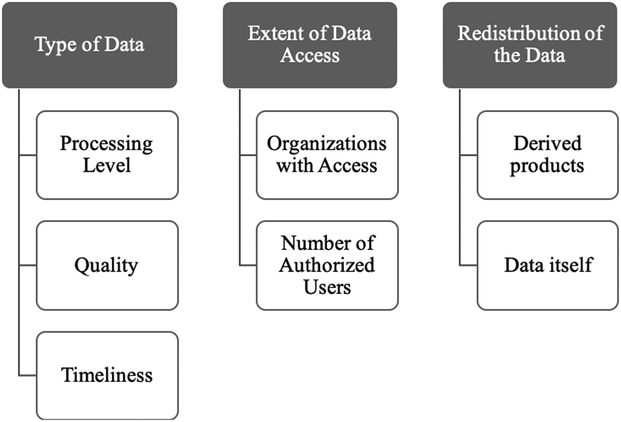
Framework for evaluating data buy license agreements.
Using this framework, it is possible to systematically compare licenses for past data buys or public–private partnerships. For the purposes of this article, I look at the example of the NGA EnhancedView program, the NASA SeaWiFS program, the Canadian Radarsat 1 program, and the German TerraSAR-X program.
NGA Enhancedview
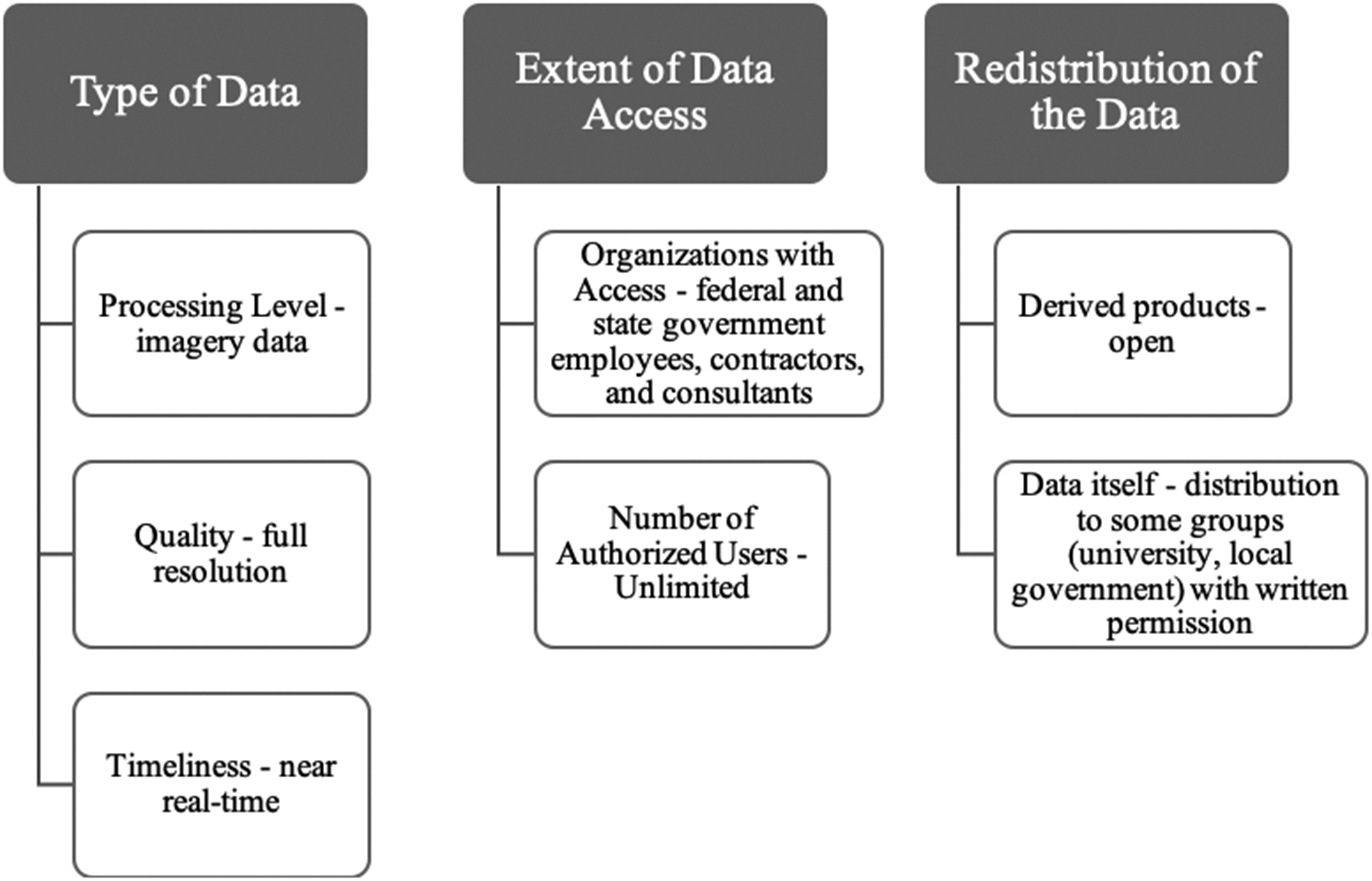
The U.S. NGA awarded a combined $7.3 million dollars in two 10-year contracts with commercial remote sensing firms Digital Globe and GeoEye. 3 Under the program, NGA can receive unprocessed sensor data, requirements-compliance processed imagery, imagery services, and imagery-derived products. Under the agreement, licensed users include all members of the U.S. federal government. These users are able to generate an unlimited number of hard and soft copies of the data and to generate any derived product using the imagery. Derived products, which are derived from the imagery but no longer look like an image or retain image characteristics (such as maps or line drawings), can be shared freely. 4
The data can be provided to government contractors and university researchers supporting government contracts, state and local governments, foreign governments and intergovernmental agencies, and nongovernmental organizations and nonprofit organizations. NGA evaluates requests to share and release data on a case-by-case basis. The data must be shared to support a U.S. government purpose, with a direct benefit to the U.S. government, and the recipients of the data must be educated as to the terms of the license. The license expressly prohibits sharing the imagery with anyone planning to sell it or use it for commercial gain. 4 The government is allowed to make a limited volume of imagery available for full public dissemination. 5 A summary of these attributes is shown in Figure 2.

National Geospatial-Intelligence Agency EnhancedView program data agreement attributes.
NASA Seawifs
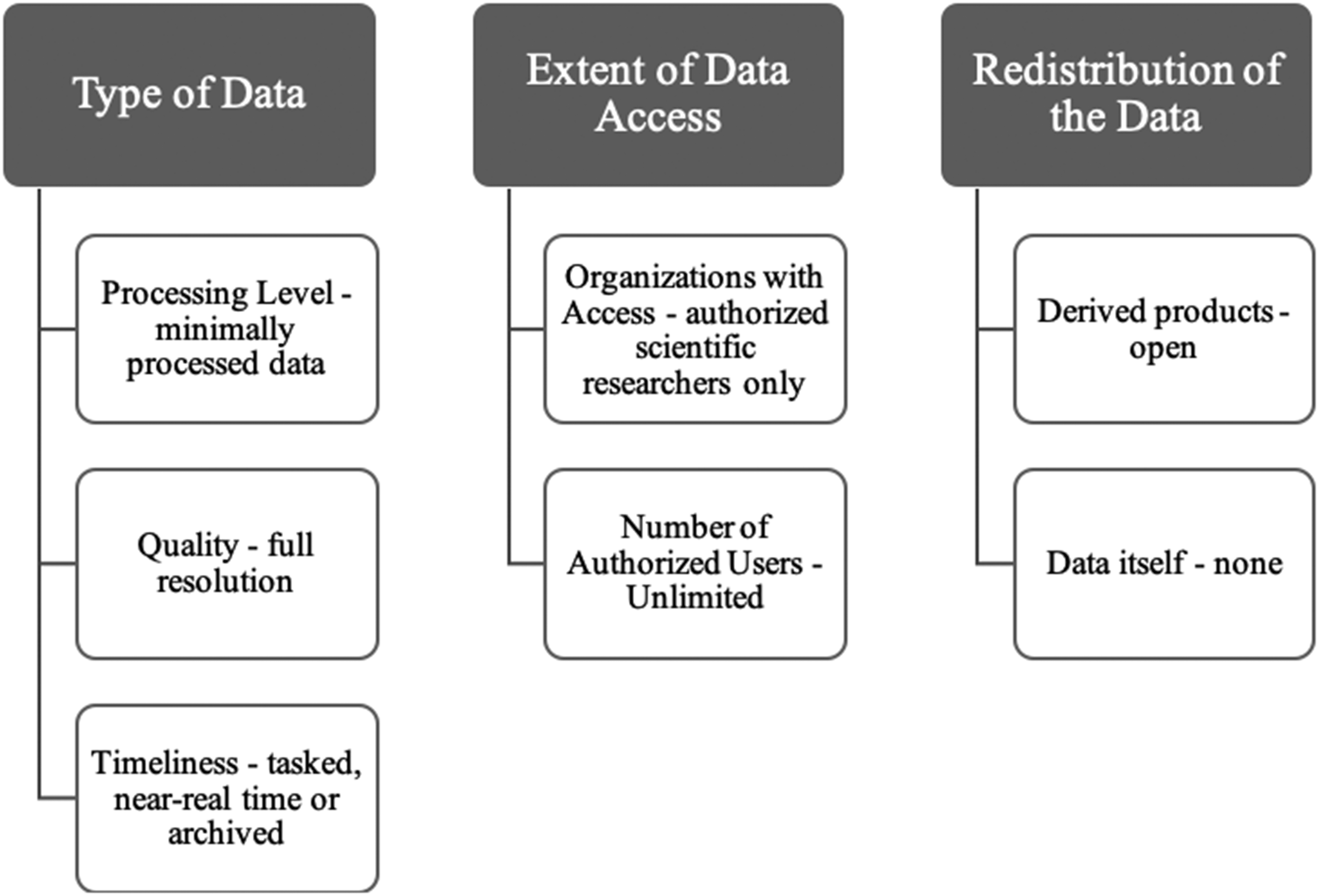
The U.S. NASA SeaWIFS was developed in the 1990s in partnership with the Orbital Sciences Corporation. Under the agreement, Orbital built and launched the SeaWiFS sensor, and NASA agreed to purchase 5 years of science data from the instrument. The satellite operated beyond its expected lifespan, and the agreement was extended to cover the full 13 years of operations. 6
Under the contract with Orbital, NASA received raw data directly collected at 12 selected ground stations. Only authorized SeaWiFS researchers were allowed to access the SeaWiFS data, and only for research and educational purposes. Becoming an authorized user required submitting a written proposal to NASA, with responses often provided within a day. All commercial users were required to work directly with Orbital. A selection of the NASA-authorized users were able to receive near real-time data, primarily for validation efforts and field studies. After 14 days, the data were placed in a NASA archive, where it could more easily be accessed by all authorized users. The license allowed for data to be made openly available to all users after 5 years. 7 Figure 3 includes a summary of these attributes.

National Aeronautics and Space Administration SeaWiFS program data agreement attributes.
Canada Radarsat 2
Canada's RadarSat 2 was developed as a collaboration between the Canadian Space Agency (CSA) and MacDonald, Dettwiler and Associates Ltd. (MDA). The satellite was launched in December 2007. Under the agreement, both organizations contributed to the cost of developing the satellite, with CSA recovering its investment through the supply of RadarSat-2 imagery to the Canadian government.8,9
The government license allowed for access to “imagery data,” with reverse engineering or decompiling of the product expressly prohibited. The license permitted use by federal government employees, as well as subnational (state or territorial) government users. Government-owned commercial entities, local governments, and universities were not considered authorized users under the contract. Written permission from MDA was required to provide data to these entities. Those interested in the data for commercial purposes were advised to work with MDA directly. Under the license, data could be copied an unlimited number of times, stored, and provided to employees, contractors, and consultants for internal use only. Imagery could also be included in printed reports or online documents as long as the format did not allow manipulation of the product and was for noncommercial use. Value-added products could be distributed freely. 10 Figure 4 includes a summary of these attributes.
Canadian RadarSat-2 program data agreement attributes.
Germany Terrasar-X/TanDem-X
The TerraSAR-X and TanDEM-X missions were developed as part of a public–private partnership between the German Ministry of Education and Science, represented through the German Aerospace Center (DLR), and Airbus Defense and Space. Airbus developed, integrated, and tested the spacecraft while DLR implemented the satellite control program and the payload ground segment for reception, processing, archiving, and distribution of the X-band SAR data. Generally, Airbus was in charge of commercial distribution of the data while DLR took charge of science data distribution. 11 It is, therefore, DLR that licenses TerraSAR-X/TanDEM-X data for scientific use. A license agreement between DLR and the principal investigator allows for transfer of data to coinvestigators named in the license agreement. The data must be used solely for the purpose of the agreed project and only for the period of time approved by DLR. 12 It is not clear whether there are plans to widen access to the data in future. A summary of these attributes is shown in Figure 5.
TerraSAR-X/TanDEM-X program data agreement attributes.
Discussion
Examination of these four programs demonstrates the way that existing arrangements have been defined along the framework attributes, highlighting both commonalities and subtle differences. The programs were similar in terms of their restrictions on commercial use of the data, not surprising given the nature of these arrangements. Most of the programs also included fairly broad provisions for federal government use and allowed for free distribution of derived products. None of these programs distinguished distribution or redistribution of the data based on changes in data quality. Only the SeaWiFS program distinguished availability based on timeliness. It was also the only program to expressly include terms allowing for long-term archiving and provision of the data.
As noted earlier, the development of this framework, and its application to a sample of existing data purchase agreements, is the first step in improving our understanding of options and efficiencies in designing government data purchase agreements. To fully understand the impact of these variations, steps must be taken to carry out an empirical evaluation of the impact these policies had on data distribution and use. To what extent has the data from these various arrangements been used by the scientific, government, nonprofit, and commercial value-added sectors? Are there particular attributes of the data access agreements—number of users, timeliness, and so on—that correlate strongly with greater distribution and use for particular groups?
Conclusion
For decades, governments around the world have shown interest in supporting and working with the private satellite remote sensing sector. However, purchasing data, which typically requires restricting access to the data in various ways, can decrease the extent to which government agencies are able to maximize use of the data and achieve their missions or priority goals. This article presented a framework that can be used to systematically examine the many potential variations among data purchase agreements. Future empirical research could help to identify the relative impact of variations along each of these dimensions, enabling informed decision-making in the development of future arrangements. However, even without this empirical data, decision-makers crafting public–private partnerships or data purchase agreements can use this framework to ensure that each attribute within the framework is fully addressed and to push for arrangements that maximize data access in each dimension.
Footnotes
Author Disclosure Statement
No competing financial interests exist.
Funding Information
No funding was received for this article.