




Abstract
Abstract
With a projected increase in extreme weather events through the duration of the 21st century, coastal communities will face a host of challenges. An underexamined component of future threats is the mobilization of pollutants, which can be dispersed by disruptive weather phenomena. This research examines extreme weather threats along multiple U.S. coastal counties. With nearly 40 percent of all Americans living in shoreline and coastal counties, along with the ubiquity of legacy pollutants within these regions, the research is relevant to inhabitants of coastal communities and those beyond. This study introduces the Toxics Mobility Inventory (TMI) in order to inform more programmatic processes for: 1.) coastal planning and management, 2.) the remediation of toxic sites, and 3.) community resiliency. Furthermore, it is an impetus for emergency and disaster response officials to recognize threats and inform response and mitigation procedures.
Introduction
Legacy pollution, including brownfields and Superfund sites, is ubiquitous throughout the United States. One estimate suggests that there are over 450,000 brownfield sites in the United States, and the U.S. Environmental Protection Agency (EPA) has over 1,300 registered Superfund sites across the nation.1,2 Millions of Americans live within one mile of over 300 Superfund sites that are flood prone or vulnerable to sea level rise. 3 Additional threats are posed by pharmaceuticals and personal care products that are prevalent in the environment 4 and Concentrated Animal Feeding Operations (CAFOs), which are pervasive, particularly in southeastern coastal states, where they threaten ecologies and undermine local water quality due to leaching in waste-storage lagoons. Flood waters and storms have the acute potential to mobilize such lagoons.
Over half the U.S. population lives in the more than 670 coastal counties that, when excluding Alaska, account for only 17 percent of the nation's land mass. 5 A recent projection forecasts that by 2100, coastal communities along the Atlantic and Gulf Coasts will be exposed to high tide flooding every other day. 6 Emblematic of the convergence of the population and predicted flooding was Hurricane Florence, which in September of 2018 swept through the Carolinas. While the totality of environmental and economic damage is still unknown, the storm was responsible for over 50 deaths, caused nearly 36 inches of rainfall in eastern North Carolina, storm surges of up to 10 feet, and numerous rivers to reach record flood heights. 7 The hurricane undoubtedly intersected with the thousands of CAFOs, over a dozen Superfund sites, and innumerable brownfields in the region. When considering the aforementioned within the context of the advance of climate change-related phenomena, including storm surges and increased storm intensity, flooding and related events, these threats become even more complex. Increased attention must be given to the interplay between toxic sites and the proliferation of threats that extreme weather will induce.
This research offers a template for assessing and responding to the harmful impacts that will converge with the interface of extreme weather events and toxics, whose resultant combination will threaten human communities and ecologies alike. It is anchored by a conceptual framework that can be used by multiple actors to consider these threats. The research used brownfield and Superfund databases to pinpoint where sites are located. Geographic information systems (GIS) spatially displays the interface between Superfund sites and potentially catastrophic weather events. For exemplary purposes, the analysis explores sites within Hillsborough County, Florida (Figures 1 and 2). Furthermore, it illuminates the prevalence of both Superfund sites and CAFOs in North Carolina's coastal counties (Table 1) to make clear the prevalence of those facilities in the wake of Hurricane Florence.

Hillsborough County, Legacy Pollution and Race: Percentage of people of color in census block groups and location of Superfund sites
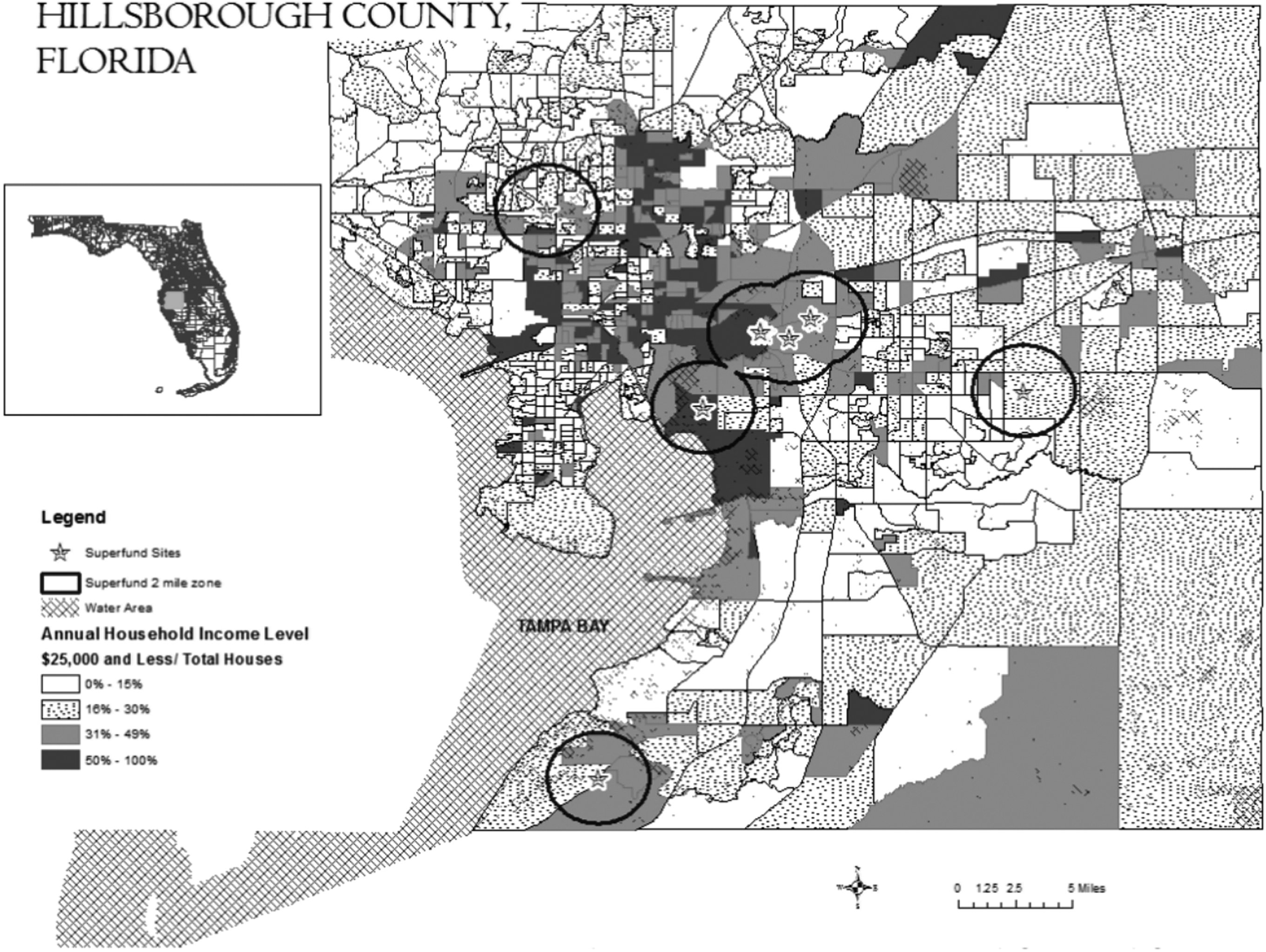
Hillsborough County, Legacy Pollution and Income: Percentage of households making less than $25,000 in census block groups and location of Superfund sites
NOAA Coastal Counties in North Carolina with: 1) Number of CAFOs, 2) Superfund Site Prevalence, and 3) Demographic Information *
CAFO: Concentrated Animal Feeding Operation
Materials and Methods
This study focuses on toxic sites in Florida for several reasons related to the state's susceptibility to water-based disasters. First, the mean elevation of the state is 30 m, the third-lowest elevation in the nation. Second, with nearly 12,000 square miles of the state covered by water, it ranks third in terms of water area. Finally, it ranks second in coastline length. The U.S. Department of the Interior's Geological Survey has long recognized the enormous amounts of water required by chemical industries. 11 Additionally, considerable industrial activity and other hazardous waste-producing activities have amassed near Florida's coastal communities and near urban population centers, which produce an assortment of intergenerational threats to public and environmental health. In the case of Florida, this can largely be substantiated by the proliferation and location of the state's brownfields: Broward and Hillsborough Counties alone have over 90 designated brownfield sites. 12
While chronic toxic threats have long burdened public health, innumerable communities will face concurrent acute threats from extreme weather events. Coastal communities, both domestic and global, are on the frontline of storms, and in recent years have been battered. In 2017 the National Oceanic and Atmospheric Administration (NOAA) identified 17 weather- and climate-related disasters causing damage of over $1 billion in the United States, 13 three of which were hurricanes. The 2017 hurricane season dispersed toxins across the Caribbean and U.S. Gulf Coast, and in the case of the latter, over 150,000 homes were placed at increased risk due to threats related to mold, fumes, and toxic water from flooding. 14
Responses to toxic threats are further complicated when they are coupled with less sensational events and short-term disruptions of life (e.g., floods, tornados). The threats to coastal communities impact a cross-section of vulnerable parties that include disaster response workers, petrochemical industries, and populations that are not highly mobile and have difficulty quickly evacuating. With the potential for extreme weather, including catastrophic storms, along with related events such as sea-level rise, forecasted to increase due to anthropogenic climate change, the bridging of responses that synthesize these threats becomes urgent. This research urges further scientific exploration of the behavioral impacts that extreme weather events will have on legacy pollution and how toxics will potentially be mobilized; it also points to the need for policies that will address consequent issues.
The Toxics Mobility Inventory (TMI) framework is a tool to be used by an assortment of actors, including emergency response and management officials, policy makers, evacuation coordinators, and urban planners (Table 2). It was developed to consider a union of isolated threats that will converge given predicted weather events coupled with environmental and socioeconomic conditions (i.e., extreme weather events and expected increased impacts, the prevalence of legacy pollution and the potential interface of toxics, along with social and environmental justice concerns).
A List of TMI Stakeholders, along with Sample Indicators for Various TMI Categories *
TMI: Toxics Mobility Inventory
Socioeconomic conditions are stressed here because, as noted in Pastor et al., 15 the inability to withstand shocks amplifies the devastation of a storm. Climate change and extreme weather events are projected to have significant social impacts on human communities. However, it should be noted that the effects faced by communities from a singular weather event will be uneven, apart from the physical damage directly attributable to the event itself, because of factors such as access to transportation (or lack thereof), the economics of relocation, and a desire to protect material assets. Furthermore, threats to culture and states' inability to provide human security heighten stress, increasing the potential for violent conflict, 16 and result in increased migration. Coastal and low-lying areas and their inhabitants will be particularly vulnerable as these areas are projected to suffer from the prevalence of submergence, flooding, and erosion related to sea level rise. 17
Coastal vulnerability will be further exacerbated by extreme weather events. According to the Intergovernmental Panel on Climate Change 5th Assessment, climate-related drivers include sea level rise, tropical and extratropical cyclones, waves, extreme sea levels, and freshwater inputs and are all projected to have a range of consequences for coastal communities. (See Table 3.)
Climate Drivers and Effects *
Adapted from Wong, et al. 17
This study builds upon similar research that has received regional and national attention for at least the last decade. Preparedness and resiliency in the face of extreme weather is influenced by a variety of factors, including: degree of trust in local governments, social and political capital, and access to communication technology before and after weather events. 18 The potential for exposure amongst marginalized populations remains troublesome and prevalent, considering the scant attention local sustainability planning has given to vulnerable communities,19,20
Texas OneGulf, 21 a working group that broadly evaluates Gulf Coast disasters, has considered efforts to assess and mitigate the toxic sludge that forms as a result of water infiltrating and mobilizing chemical contaminants. Toxic sludge is a crude term used to define the innumerable chemicals that materialize after flooding and natural disasters, leaving residents and first responders with heightened exposures. NOAA's Beachfront Vulnerability Index 22 is also useful in that it informs coastal communities' exposures to storm surges and erosion; however, it does not consider the pressing toxic threats within or adjacent to these communities.
The year 2017 saw 44 flood or hurricane major disaster events—eight more than the previous year. This is in concert with the increasingly prominent threat of high-tide flooding. 23 While the U.S. Government Accountability Office has begun to assess flood-related risks of National Priorities List (NPL) sites, the recent EPA prioritization of the most vulnerable Superfund sites does not account for flooding or sea level rise. 3 Floods and resultant water damage have placed crippling tolls on communities, leading to human casualties, infrastructure and transportation network damage, and other property damage. 16
It has been established that human activity, along with processes invoked by urbanization, have intensified both urban runoff and related pollution, and that the concentration of trace elements are more prevalent in industrial areas than residential ones. 24 This is critical given the attention that TMI places on Superfund sites and brownfields. Furthermore, floods occur more than any other natural disaster and are the most consequential in terms of the number of humans affected by them; they lead to the highest death tolls.25,26
Evidence suggests that flooding has the ability to transport both stationary chemicals (e.g., toxics stored in household garages or barns) and to remobilize chemicals such as chlorinated pesticides and organophosphates, as well as other agricultural chemicals, and concentrated levels of dioxin, volatile organic compounds (VOCs), cyanide, and heavy metals already released into the environment. 27 Additionally, heavy metals such as mercury have the ability to be transported across the flood plain via runoff, leading to the bioaccumulation of the element. 28 Elements such as arsenic have been found in sediment after flooding events, 29 and metals such as cadmium, copper, and lead are persistent in aquatic environments and have the ability to form in-stream toxicity. 24
It is important to classify metals into their two aquatic states, either dissolved or in particulate form. The former is much more mobile, while the latter can be considered less of a threat in the particulate state, but given the proper conditions, can be dissolved and become bioavailable. 24 One evaluation illuminated the infiltration of historic arsenic, not indigenous to an area pre-flood, to local schools and playgrounds post-flood, 29 creating a considerable public health threat due to the heightened vulnerability of children.
In a review of epidemiological studies related to the health effects of toxics mobilization following floods, Euripides and Murray 27 noted the redistribution of chlorinated pesticides and organophosphates along with herbicides, including banned toxics (chlorinated pesticides) and elevated levels of various agriculture chemicals along concentrated levels of dioxin, VOCs, cyanides, and heavy metals. It is vital to acknowledge the threats that mobilized legacy pollution poses to human communities. The array of adverse human health effects, based on exposure types, can range from neurobehavioral dysfunction, including memory loss, to cerebral atrophy and respiratory infection. 30
The TMI is informed by indicators pertaining to: 1) three climate-related factors (storm surge potential, projected storm frequency, and storm intensity); 2) those looking at the location, clustering, and chemical profile of pollution sites; 3) the potential for freshwater input to affect the mobilization of toxics; and 4) the socioeconomic conditions that inform vulnerability. To see how the inventory manifests, the study initially looked at all NOAA-classified coastal counties in Florida and North Carolina to come up with a baseline of counties that would be on the frontlines of tropical storm activity in the United States. This was followed by categorizing the Florida-based Superfund sites in Hillsborough County and plotting them using Esri® ArcMapTM software, and then adding economic and racial layers to provide a socioeconomic contextualization for the sites.
The variables of race and income were used, which, though they are not determinants of vulnerability, do inform it. Data for each county included the percentage of people of color and the percentage of households in each census block group with annual household income at or below $25,000, a figure analogous to the federal poverty line for a family of four. A two-mile radius around Superfund sites was created to capture how sites are situated within these counties. This data captures which groups have heightened proximity to these sites and immediate exposure in the event of facility or site breach.
For purposes of illustration, Figures 1 and 2 highlight seven Superfund sites, along with the socioeconomic indicators. While sites are scattered across a number of socioeconomic communities, all sites are within a two-mile radius of neighborhoods with heightened poverty levels (at least 31 percent of households with incomes at or below $25,000 annually and in neighborhoods with a minimum of 31 percent of residents identified as people of color).
Discussion
There is a need for awareness about the unacknowledged threat toxics present during extreme weather events. By identifying specific sites in a GIS analysis, this study presents a geospatial representation of site proximity to coasts, communities, and each other. While a political economy that allows for the proliferation of toxic sites is not within the purview of this research, it is conceded that the coupling of risks associated with hazardous facilities and vulnerable demographics are indeed well cemented as part of the environmental justice literature,31,32 and that heightened vulnerability can be a function of, and exacerbated by, racial inequality, poverty, and access to health care.
With this knowledge, a few key determinations are essential. First, as climate threats expose coastal regions to greater harm, comprehensive analysis based on population groupings and chemical analysis, coupled with local topography, the chemical behavior of toxins, and specific storm-related analysis, must be conducted. This analysis should involve tools not limited to remote sensing and GIS, climate modeling, and the use of a range of socioeconomic data sets.
In introducing the TMI, the authors have offered professionals (including scholars and practitioners), policy makers and planners, emergency response officials, and communities a tool to aid in the prioritization of site remediation and the ordering of evacuation based on community characteristics. This research adds an increased urgency to reevaluating priorities, and also underscores the necessity of urban development and disaster and sustainability planning that is informed by consciousness of these conditions.
Consider the devastation that Hurricane Harvey caused along Texas's Gulf Coast during the summer of 2017, and the prevalence of oil refineries and other petrochemicals in that region. Further research and policy goals should give attention to, and raise questions, including: 1.) How should state and federal government programs identify, prioritize, and treat sites that are problematic due to their geographic location within the context of extreme weather? 2.) What vulnerabilities will storm surges, sea level rise, and other climate-change related phenomena promote? 3.) How should vulnerable populations, with diminished capacity to withstand the shocks of climate events, hazardous waste, and legacy pollutant migration, act to repel, mitigate, and/or neutralize threats; and 4.) How should emergency responders act in the face of the potential increased encounters with waste and pollution in a TMI-relevant context?
This research seeks to provide a framework for future exploration for specific analysis as to how toxins will be dispersed in the hopes of informing proactive behavior in the remediation of sites. A political economy that has allowed toxic sites to persist for decades without remediation is not conducive to public and ecological well-being and sustainability, and must also be reorganized.
While this research offers a framework to look at the potential secondary disasters caused by the mobilization of site-based toxics following extreme weather events, to be clear, the authors recognize that legacy pollution sites exacerbate vulnerabilities, and the potential for environmental and human health threats must be comprehensively characterized based on the composition of respective sites. With the maturation of climate change and the development of associated phenomenon including intensified storm surges and elevated high tides, coastal communities will be disrupted. Due to existing environmental threats, including legacy pollution, the amalgamated threats will be magnified. Preliminary findings show an assortment of toxic sites in coastal areas vulnerable to tropical storms, as well as in high-poverty communities with substantial populations of color. Governments will have to pursue policy options to remediate legacy pollution sites in order to avoid distribution of toxic chemicals in the face of extreme weather events.
In concert with the increase of environmental impact assessments with considerations for climate change that have grown in recent years in public infrastructure and building project planning, 33 more holistic considerations that focus on fortification against legacy threats need to be engaged in and acted upon. Fresh approaches will be necessary from multiple levels of government. Consider that of the over $48 billion that the Federal Emergency Management Agency (FEMA) has dispersed via post-flood public assistance grants between 1998 and 2014, none of those funds were directly earmarked for the threat of floods to toxics sites. 34 It is imperative that governments and other germane actors begin to incorporate TMI frameworks and thinking into comprehensive planning in order to adequately address forthcoming challenges in impacted areas.
Footnotes
Author Disclosure Statement
No competing financial interests exist.