
Abstract
Background:
Rift Valley fever (RVF) is an emerging vector-borne zoonotic disease that represents a threat to human health, animal health, and livestock production, particularly in Africa. The epidemiology of RVF is not well understood, so that forecasting RVF outbreaks and carrying out efficient and timely control measures remains a challenge. Various epidemiological modeling tools have been used to increase knowledge on RVF epidemiology and to inform disease management policies.
Aim:
This narrative review gives an overview of modeling tools used to date to measure or model RVF risk in animals, and presents how they have contributed to increasing our understanding of RVF occurrence or informed RVF surveillance and control strategies.
Methodology:
Systematic literature searches were performed in PubMed and ISI Web of Knowledge. Additional research work was identified from other sources.
Results:
Literature was scarce. Research work was highly heterogeneous in methodology, level of complexity, geographic scale of approach, and geographical area of study. Gaps in knowledge and data were frequent, and uncertainty was not always explored. Spatial approaches were the most commonly utilized techniques and have been used at both local and continental scales, the latter leading to the implementation of an early warning system. Three articles using dynamic transmission models explored the potential of RVF endemicity. Risk factor studies identified water-related environmental risk factors associated with RVF occurrence in domestic livestock. Risk assessments identified importation of infected animals, contaminated products, or infected vectors as key risk pathways for the introduction of RVF virus into disease-free areas.
Conclusions:
Enhanced outbreak prediction and control and increased knowledge on RVF epidemiology would benefit from additional field data, continued development, and refinement of modeling techniques for exploring plausible disease transmission mechanisms and the impact of intervention strategies.
Introduction
Since 1931, RVF outbreaks have been reported in most countries in Western, Southern, and Eastern Africa and in the Arabian Peninsula. RVF virus is present in a variety of ecosystems, including arid areas (Northern Senegal, Yemen), irrigated areas (Aswan, Delta of Senegal River), forest (Madagascar), and wetlands called dambos (Kenya, South Africa). The disease has spread from the African mainland to Madagascar in 1991 and to the Arabian Peninsula in 2000 (Bird et al. 2009). Little is known about the mechanisms of RVF virus maintenance and resurgence in these different ecosystems. From previous studies, it appears that the sudden appearance or surge in quantity of water in the environment allow infected Aedes eggs that have been dormant for several months or years to hatch, causing pullulation of RVF vectors. Examples of such causes include unusual heavy rainfall (Linthicum et al. 1999), flooding following dam construction (Digoutte and Peters 1989), and certain rainfall patterns during the rainy season (Mondet et al. 2005). Adult infected Aedes females feed on local ruminants and infect them, allowing viral amplification within the host. Animals may also acquire infection by contact with infected animal tissues (Pepin et al. 2010). During epidemics, presence of water may also allow virus circulation in secondary vectors, such as Culex mosquitoes (Linthicum et al. 1985, Fontenille et al. 1998). Humans are exposed to RVF virus infection mainly by direct contact with infected animals and organs, whereas virus transmission through mosquito bites is rare (WHO 2010).
Reviews published so far on RVF epidemiology have focused on describing current knowledge on disease or vaccine developments (Gerdes 2002, 2004, Bird et al. 2009, Ikegami and Makino 2009, Labeaud et al. 2010, Pepin et al. 2010); others have included RVF as part of broader discussions on emerging diseases, climate change and anthropogenic factors (Chevalier et al. 2004a, 2010, Dufour et al. 2008, Martin et al. 2008, Clements and Pfeiffer 2009), or disease surveillance and control strategies (Martin et al. 2007, Clements and Pfeiffer 2009). Although little is currently known about RVF determinants, studies using different modeling approaches have explored RVF risk. At the animal level, RVF risk was defined as RVF prevalence or incidence. At a population or geographical level, the risk of RVF could be the risk of RVF virus introduction or emergence in an RVF-free area or population, the risk of RVF virus persistence or endemicity in previously affected areas, the risk of RVF virus resurgence or re-emergence in RVF endemic areas; and finally, the risk of RVF virus spread, corresponding to the sustained spread in time (and space) of an epidemic.
Here, we present the different modeling approaches that have been used to quantify and analyze these risks, with a view to highlighting their use for improving our knowledge on RVF occurrence, disease surveillance, and control strategies.
Methods
PubMed and ISI Web of Knowledge were searched using the terms “rift valley fever” AND (“risk” OR “map*” OR “model*” OR “epidemiology”), using the “all fields” option to allow retrieval of articles in which the search terms appeared in the titles, abstracts, or keywords. Abstracts retrieved were read by the same person, and inclusion and exclusion criteria were applied to identify the final list of publications for full-text reading. Inclusion criteria were articles using qualitative or quantitative techniques to model RVF risk in animals, the latter including statistical and mathematical approaches. Exclusion criteria were reviews, outbreak notifications, prevalence studies, descriptions of clinical disease, pathogenicity and diagnosis in humans or animals, experimental infections in animals, development of vaccines, genome sequencing alone, entomological surveys alone, and articles strictly on remote-sensing methods. Additional relevant studies identified in the reference lists of the selected articles were also included if they met the criteria described above.
By using widely recognized scientific literature databases with relatively general search terms, by including additional references identified through the articles identified in the database search, and because we were able to include articles written in English and French, it is likely that a representative fraction of the literature on the subject has been identified.
Results
Literature search
A total of 525 abstracts were retrieved through the database search, with 183 articles overlapping between databases. After the inclusion and exclusion criteria had been applied, 36 pieces of research work were selected, from which 31 were articles from peer-reviewed journals, 2 were scientific opinions from official health agencies, 2 were conference proceedings, and 1 was a Ph.D. thesis. Full access to one article was not possible, not even through the British Library. There was a large heterogeneity in the works regarding research methods, level of complexity, scale of studies, and location. Articles included in the review were classified into risk factor studies, spatial techniques, dynamics transmission models, and risk assessment (Table 1). Almost half of the articles (n=14) reported to use spatial techniques. Three quarters of the articles (n=29) related to studies in Africa, particularly research conducted in Kenya and Senegal/Mauritania only (n=20). Two articles were found for Egypt and Nigeria. Outside Africa, seven published works related to the Arabian Peninsula, Europe, or the United States (Fig. 1).
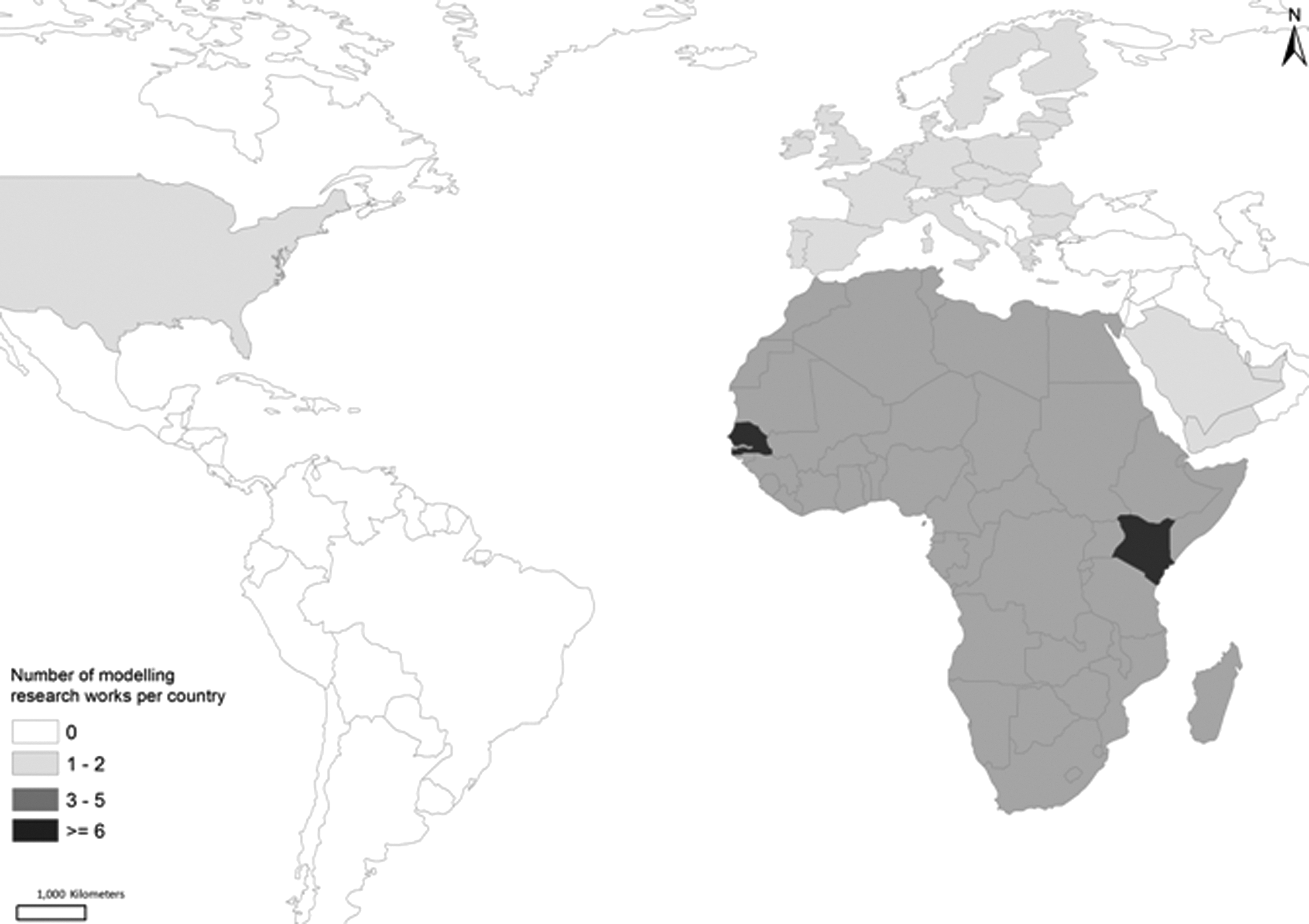
Map showing distribution of publications that include modeling of Rift Valley fever epidemiology.
AFSSA, Agence Francaise de Securite Sanitaire des Aliments; EFSA, European Food Safety Authority; ENSO, El Nino Southern Oscillation; NDVI, Normalized Difference Vegetation Index; RVF, Rift Valley fever; RVFV, Rift Valley fever virus; SST, Sea Surface temperature.
Risk factor studies
Risk factor studies are observational studies conducted in the natural environment of the animals, collecting data about disease occurrence, and potentially associated factors (Pfeiffer 2010). In this section were included targeted surveys collecting field disease data and looking at their association with potential risk factors, using information collected from field measurements or extracted from remote-sensing images. For RVF, such studies have been conducted in Senegal, Mauritania, and Saudi Arabia. Both intrinsic risk factors (at the animal level) and extrinsic ones (related to the natural environment) have been identified.
Following the 1987 outbreak in Mauritania and Senegal, RVF prevalence was lower for animals below 1 year of age, whereas incidence was similar for all age groups, probably due to a high mortality in young animals (Lancelot et al. 1990). Further studies identified a higher serological prevalence in adults compared with younger animals, but no difference in RVF incidence between sheep, goats, and cattle (Lancelot et al. 1990), or in RVF prevalence between sheep and goats was found (Guillaud et al. 1988, Thiongane et al. 1991, Zeller et al. 1995a; Olaleye et al. 1996), which is not sufficient to quantify difference of species' susceptibility in acquiring RVF infection or exhibiting clinical disease.
In all studies, extrinsic risk factors associated with RVF or RVF virus exposure were found to be water-related. In Mauritania and Senegal, RVF incidence following the 1987 outbreak was found to be associated with the presence of lakes or large surface water bodies and with high rainfall (Lancelot et al. 1990). In West Africa, RVF prevalence was higher in the Guinean zone, a wetter area compared to the Sudanian or Sahelian zones (Zeller et al. 1995b). In the Ferlo region of Senegal, during the rainy season, nomadic herds set up their camps where water and pasture are available for animals—typically nearby temporary ponds, which are also breeding habitats for RVF vectors. Sheep exposure to mosquito bites and RVF serological prevalence and incidence showed spatial heterogeneity between such ponds (Chevalier et al. 2004b, 2005, 2009). Authors suggested that ecological factors associated with infection status of the ponds' vector population should be investigated to improve existing surveillance and advise farmers on preventive measures. Indeed, in Ferlo, using remote-sensing data, landscape closure around ponds, a measure of vegetation density, and thus a higher probability of mosquito presence, was found to be associated with increased serological incidence in small ruminants (Soti et al. 2007). Finally, in Saudi Arabia, seropositivity in small ruminants was associated with higher mosquito density, higher rainfall, and the presence of lakes or ponds (Elfadil et al. 2006).
To summarize, water-related factors in the natural environment of the animals increased the risk for animals to acquire RVF infection. Also, younger animals were shown to be more susceptible, but no difference between cattle, sheep, and goats could be demonstrated. Knowledge could be improved by examining risk factors for serological and clinical RVF incidence at the animal level. To achieve this, studies need to be conducted during an outbreak, but this is usually difficult since the main priority during an epidemic is to achieve control.
Spatial techniques
Data-driven spatial models
Spatial data-driven models use statistical methods to define relationships between factors and disease distribution (Pfeiffer et al. 2008). This section includes studies that used data from RVF outbreaks or virus circulation to predict disease distribution, sometimes including a temporal dimension.
Predicting RVF resurgence and spread in RVF endemic areas
The use of climate models: In Kenya, the temporal pattern of RVF epidemics was shown to be associated with heavy rainfall (Davies et al. 1985). Later, satellite imagery was used to develop an index, the potential viral activity factor, based on Normalized Difference Vegetation Index (NDVI) data, that could identify areas with potential RVF activity (Linthicum et al. 1987). This model was then improved by incorporating warm El Niño-Southern Oscillation-related climatic indices, because El Niño-Southern Oscillation warm events were known to increase precipitations in East Africa. Those indices were, namely, Pacific Ocean Sea Surface Temperatures (SST) and Western Indian Ocean SST. Indeed, a retrospective study using time series analysis showed that NDVI and SSTs anomalies were able to predict the three RVF outbreaks in Kenya between 1982 and 1998 while not generating any false-positive predictions. Additionally, combined SSTs anomalies would be indicative of the duration and the intensity of RVF outbreaks (Linthicum et al. 1999). Those findings were used to set up, in 1999, an early warning system (EWS) for RVF, monitoring the following regions: Sub-Saharan Africa, the Nile River Basin in Egypt, and Saudi Arabia (DoD-GEIS 2009). This EWS detected retrospectively RVF virus activity in Zambia in 1985/86; Mauritania/Senegal in 1987; Madagascar in 1992; Eastern Africa in 1982/1983, 1988/1989, and 1997/1998; and Saudi Arabia in 2000, but also, in the late 2000s, it forecasted RVF activity in East Africa in 2006/2007 (2–6 weeks in advance), Sudan in 2007, and Southern Africa and Madagascar in 2007/2008. However, it failed to retrospectively detect limited RVF virus activity in Burkina Faso in 1983, Central African Republic in 1985, or Senegal in 1993 (Anyamba et al. 2002, Anyamba et al. 2006, Linthicum et al. 2007, Anyamba et al. 2010). Additionally, the 2006/2008 predictions cited above only partially captured the spatial distribution of affected areas, providing the best spatial predictions for East Africa, and the poorest predictive performance, in decreasing order, for Sudan, Madagascar, and Southern Africa. A possible lack of sensitivity of the system was acknowledged with authors listing a number of potential causes. The NDVI threshold could have been set too low or the true geographical locations where humans had become infected might not have been accurate in some cases. Furthermore, the model validation was only bases on RVF human cases, not livestock cases, and the migration of infected animals could have generated cases outside high risk areas (Anyamba et al. 2009, Anyamba et al. 2010). Finally, a similar framework using satellite imagery has now been applied to the United States to forecast the potential emergence of RVF vectors (Linthicum et al. 2007).
Mapping areas of RVF persistence to target surveillance at continental and national levels
In Africa, areas for RVF endemicity were identified by modeling inter-epidemic seroprevalence estimates extracted from the literature, using a mixed-effect logistic regression model accounting for spatial dependency in a Bayesian framework (Clements et al. 2007a). Areas with high seroprevalence were those having experienced previous outbreaks, whereas low-seroprevalence areas could be further considered in the context of trade as a potential risk to export infected animals. It was emphasized that there was no data available for many areas. Such maps were found to be useful to potentially target allocation of resources and to inform decision makers on the threat posed by unknown risk areas for which no data were available (Clements et al. 2007a).
At a national level, in Senegal, serology from sheep, goat, and cattle herds from country surveillance programs between 1988 and 2000 were fitted to a spatial logistic regression model to map RVF risk. The lower Senegal River basin, Southern Mauritania, and Southern border of Senegal were found to have an increased RVF risk, especially during the period March–August, which includes the beginning of the rainy season. Although the data used were not primarily collected for this purpose, the final risk maps allowed the identification of areas for potentially targeted sentinel surveillance. Finally, the presence of residual small-scale spatial variation suggested that additional spatial local risk factors might influence disease distribution (Clements et al. 2007b).
To summarize, data-driven spatial techniques have been used to predict RVF occurrence in space and time. The use of times series analysis enabled the identification of climatic risk factors to be monitored for outbreak predictions, and spatial statistical models allowed accounting for both ecological and individual covariates potentially associated with disease distribution.
Knowledge-driven spatial models
Knowledge-driven risk maps model spatial risk based on “the existing knowledge or hypothesized understanding of the causal relationships leading to disease occurrence” (Pfeiffer et al. 2008). As a corollary of this definition, building such models does not necessarily require disease data, except for model validation. For RVF, such methods are thus useful in data-scarce environments. They have been used at a local scale in Senegal and at the African continent level to identify areas suitable for RVF spread or persistence.
In the Ferlo region of Senegal, areas potentially suitable for RVF spread are being identified using a satellite imagery approach, with the ultimate aim of setting up an EWS (Marechal et al. 2008, Tourre et al. 2009). Satellite images, together with data on entomology, rainfall, and pond location, were used to identify zones potentially occupied by Aedes vexans and Culex poicilipes mosquitoes (ZPOMs) (Tourre et al. 2008). A series of such maps, superimposed with location of cattle pens, were produced for the rainy season in 2003 (July–October) (Vignolles et al. 2009) and for August 2003–January 2004, showing a decrease of ZPOMs from 25% to 1% of the land after the rainy season (Ndione et al. 2009).
Decision analysis modeling techniques were used to map suitable areas for RVF spread at a local scale in the Ferlo region of Senegal (Pin-Diop 2006) and for RVF spread and persistence at the continental level for Africa (Clements et al. 2006b). In the Ferlo region of Senegal, areas suitable for RVF spread were mapped using a hierarchical tree-decision model, including livestock density, vegetation, and location of water bodies or ponds as a proxy for vector distribution. Although not enough data were available for validation, this model allowed mapping RVF relative risk by combining RVF risk factors in a transparent fashion, accounting for livestock density using field data (Pin-Diop 2006, Pin-Diop et al. 2007). Further, multiple criteria decision analysis using fuzzy logic within a weighted linear combination framework and Dempster Shafer analysis was used to determine environmental suitability of RVF epidemics and endemicity in Africa (Clements et al. 2006b). The resulting epidemic maps showing areas suitable for RVF spread were consistent with those where outbreaks had already been reported (South Africa, Nile River, Kenya, and Southern Mauritania/Northern Senegal). Most Sub-Saharan Africa was suitable for RVF endemicity; the Sahara region was not suitable except for the extreme North of Algeria, Morocco, and Tunisia, for which a moderate suitability was estimated.
In summary, knowledge-driven risk mapping has been used at both a local and continental scale to explore the potential for RVF virus spread and persistence, but validation with disease data was not always possible. Additionally, such mapping approaches quantify disease suitability, but cannot predict where the next RVF outbreak will occur. However, such maps can be updated quite easily as knowledge develops, and can be used in the absence of disease outbreak data. Although they could be used to target interventions, decision makers should still be aware of any input data quality problems, the methods for combining them (Clements et al. 2006b), and the validity of assumptions underlying the relationships between associated risk factors and disease.
Dynamic transmission models
Mathematical models of infection transmission include explicit representation of the transmission process and relevant risk factors in the model, and tend to be used to answer questions that cannot be answered using the available data alone. Depending on the amount and quality of data available, such models can be used to explore hypotheses of disease transmission, predict incidence of infections, or assess the impact of intervention strategies (Vynnycky and White 2010).
For the Ferlo area of Senegal, the seasonality of RVF prevalence between 1991 and 1996 was estimated using mosquito abundance data over the same period (Bicout and Sabatier 2004). Using rainfall as the primary determinant of mosquito abundance, the results highlighted the relative importance of both Aedes and Culex mosquito populations in relation to RVF seasonal incidence. The potential for RVF virus endemicity was also studied in two further dynamic closed-system models. For Ferlo, a pond-level metapopulation model was built, assuming that Aedes was the sole source of virus and abundance was triggered by rainfall. Various theoretical transmission scenarios were explored and it was shown that without animal migration from outside the system, within-Ferlo virus persistence was possible if cattle moved between ponds and if rainfall did not occur at the same time at all ponds (Favier et al. 2006). Another theoretical model, also in a closed system, included two populations of mosquito vector species Aedes and Culex, and a population of livestock, and showed that the virus could persist if there was a high contact rate between hosts and mosquito vectors (Gaff et al. 2007).
To summarize, the transmission models developed to date have been useful for highlighting the importance of vector abundance for RVF virus persistence as well as the presence and the role of the two key mosquito species populations: Aedes as the source of virus and Culex as a secondary vector. Additionally, for the Ferlo area, the relative role of vector transmission and animal migration in RVF virus local persistence was explored. The scarcity of disease, vector, and animal migration data precluded exploratory modeling of multiple scenarios and model validation, and therefore intervention strategies could not be evaluated. Finally, no model on RVF virus spatial spread during an outbreak has been developed.
Risk assessment and related approaches
Risk assessment is defined as “the evaluation of the likelihood and the biological and economic consequences of entry, establishment or spread of a pathogenic agent within the territory of an importing country” (OIE 2004). Risk assessments and related approaches such as pathway assessment and ranking have been used to assess the feasibility of the introduction and spread of RVF virus into a geographical area, through animal movements or insect vectors. Ultimately, risk assessment provided a convenient platform for reviewing existing knowledge while highlighting data gaps on RVF, and allowed the design of policy recommendations.
At a continental scale, movements of infected livestock (cattle, sheep, goats, and camels) have been considered as a potential pathway for RVF virus introduction into a disease-free area, for example, in Egypt in 1977 (Sellers et al. 1982). Similarly, trade of sheep from Eastern Africa to Mecca in Saudi Arabia or in Yemen during festive periods has also been identified as a risk for the introduction of RVF virus (Davies 2006, Abdo-Salem et al. 2010), thus suggesting a ban of livestock trade as an option for preventing disease spread whenever exporting countries are identified as being in a “pre-epizootic/epidemic” phase (Davies 2006). At an intercontinental level, introduction of RVF virus via illegal importation of viraemic animals and contaminated products coming from RVF epidemic areas was an identified threat for Europe (EFSA 2005) and for the Ocean French Islands of Mayotte located close to Madagascar (AFSSA 2008). Conversely, this pathway was considered less important for RVF virus introduction in the United States, for which infected airline passengers originating from RVF endemic countries were estimated to be a more likely introduction pathway (Kasari et al. 2008).
Disease spread through infected windborne vectors was estimated to be feasible at a regional scale with introduction of infected vectors form North Sudan to Egypt being a possible scenario for the 1977 Egyptian outbreak (Sellers et al. 1982). Conversely, at an intercontinental scale, mechanical transport of infected vectors through air or sea transport was a more probable pathway for RVF introduction into the United States rather than wind carriage (Kasari et al. 2008). Additionally, a potentially increased risk of introduction, spread, and persistence of RVF virus into Europe due to environmental changes was identified, and partly attributed to the vector pathways (Gale et al. 2009). However, scarcity of data required an expert opinion elicitation process and uncertainty remained high.
In the Ferlo region of Senegal, risk assessment was used to assess the similar importance of nomadic herds and virus transovarial transmission in the maintenance of RVF virus (Etter et al. 2006). Although this question is important for understanding RVF virus persistence in this area, little detail is currently published.
In summary, risk assessments for RVF have been used for assisting decision making through exploration of routes of virus introduction, spread, or persistence at regional, continental, and intercontinental levels. Risk questions studied remained broad most of the time, data scarcity did not allow assessing the risk quantitatively, and models' uncertainty remained high. However, they did contribute to pathway ranking and generated overall guidance for future research.
Discussion
This narrative review was conducted to provide an overview of the research work that has been used to model RVF risk in animals and to highlight how they contributed to our understanding of RVF occurrence and inform surveillance and control strategies.
Models of RVF have aimed at addressing two main concerns: what is the risk of disease resurgence and spread within endemic areas and what is the risk of disease introduction into disease-free areas? In both cases, the timely implementation of appropriate disease control measures needs (i) to reliably predict RVF outbreak occurrence in time and space and (ii) to be able to control its spread as early as possible, after an outbreak has started.
Models for outbreak prediction in time and space have been developed using time series climatic indices and mapping NDVI anomalies, and led to the setting up of an EWS for Africa and the Arabian Peninsula (DoD-GEIS 2009). These predictions have been used in the Horn of Africa in 2006 to implement enhanced surveillance activities 2–6 weeks before the first RVF human cases were identified (Anyamba et al. 2009, 2010). However, the Consultative Group for RVF Decision Support (2010) estimated the time necessary between vaccines being ordered and herd immunity to be 141 days for a population of 100,000 animals, suggesting that the RVF alert would need to be given at least 5 months in advance.
Prospective predictions of this EWS for the years 2006 to 2008 have been assessed lately, and the model showed better predictions for East Africa compared with those for Southern Africa (Anyamba et al. 2010), and no assessment is yet available in relation to the recent RVF outbreak in South Africa. Finally, enhanced model validation, that is, quantifying the positive and the negative predictive values of the RVF alerts in time and space, would greatly benefit from improved disease reporting in animals and humans. In Western Africa, heavy rainfall causing RVF outbreaks at a regional scale, similar to that reported in Eastern or Southern Africa, has not been observed. Instead, small numbers of RVF cases are regularly reported, either in the Sahelian ecosystem or along the Senegal River basin and delta (OIE 2010). Not detecting these cases by monitoring NDVI anomalies could be explained by the fact that either local NDVI anomalies were below the EWS threshold (i.e., lack of sensitivity), or that emergence of these cases was associated with factors other than heavy rainfall. In Senegal, the existence of potential local factors involved in RVF virus circulation has been suggested (Clements et al. 2007b). In the Ferlo region of Senegal, these local factors could be specific rainfall patterns producing temporary ponds, alternating conditions of humidity and drought favoring Aedes egg hatching (Mondet et al. 2005). Also, the movement of infectious nomadic livestock in Senegal has been hypothesized to play a role in the re-occurrence of RVF cases in areas not covered by vector dispersal (Ndione et al. 2003, Chevalier 2004b).
There were few mathematical models exploring mechanisms of RVF virus circulation. In Senegal, a model studying mechanisms of RVF virus persistence in a closed system remained theoretical (Favier et al. 2006) and overall, transmission models looking at mechanisms for RVF virus spread during an outbreak have not been developed. Such models are of important for development of disease control policy, specifically for predicting the pattern of RVF virus spread in time and space subsequent to virus emergence, and to evaluate the impact of potential disease control options. Calibration and validation of these models must be done using disease data and data on potential risk factors collected from the field. Few risk factors studies have been conducted for RVF and most of them looked at factors associated with RVF prevalence. Indeed, collecting incidence data is challenging for several reasons. First, RVF cases are not clinically specific and laboratory confirmation is necessary. Second, virus isolation techniques are costly and time consuming, and require high biocontainment level facilities (Pepin et al. 2010). Third, during inter-epidemic periods, evidence of seroconversion in animals requires follow-up of animals, which is expensive. Data on potential factors involved in RVF virus spread would also be necessary, for example, the infectious status of livestock population, data on the vector populations, movements of animals, or the infectiousness of wild animals as a potential reservoir. Outbreak investigations collecting disease data and on potentially associated factors during epidemics would be very useful for studying disease determinants of RVF virus spread, and thus should ideally be a component of outbreak response.
To summarize, using both climatic models for predicting RVF virus emergence and spread, and epidemiological mathematical models for predicting RVF virus spread and testing, the impact of different interventions strategies would allow improved outbreak monitoring and control. It would support policy-making by allowing the timely and appropriate implementation of (i) preventive measures when an outbreak is forecast, and (ii) control measures in the early stages of the epidemics. Such measures could include destruction of mosquito breeding habitats, the impact of vaccination campaigns, and restriction of animal movements. In practice, the current lack of disease and risk factor data constitutes an important constraint for the development of such disease policy.
Furthermore, assuming that sufficient data would be available, the absence of an appropriate animal vaccine to use during an outbreak is a major limitation for controlling the disease. Two types of vaccine for animals are currently available, a live vaccine and inactivated vaccines (OIE 2009). The very immunogenic live vaccine is also teratogenic and has potential for residual virulence. It should only be used in nonpregnant livestock in endemic areas and during outbreaks, and is important to recognize that the re-use of syringes or needles will increase virus transmission (WHO 2010). Inactivated vaccines can be used in pregnant animals and in RVF-free countries, but immunization requires a primary course of two injections and yearly boosters. To be effective, vaccination should be implemented before the commencement of the outbreak. The current live vaccine cannot be used for prevention, and prevention using the inactivated vaccine is difficult to sustain in RVF affected countries for economic reasons. Vaccine research is under way (Ikegami and Makino 2009, OIE 2009).
Risk mapping was found useful for identifying geographical areas suitable for RVF persistence and spread, that is, where surveillance efforts should be targeted. Knowledge-driven approaches were found useful in data-scarce environment since their development did not depend on availability of disease data. Also, they are considered to be easy to update once additional knowledge becomes available. Data-driven risk mapping allows accounting for both ecological factors and herd-level factors. Although their use in policy-making for RVF has not been fully explored, such mapping techniques have already been developed for assisting the control of other diseases such as schistosomiasis in Tanzania (Clements et al. 2006a, 2008).
Currently available risk assessment models, although qualitative, have been used to identify legal and illegal trade of infected animals or animal products as a threat for the introduction of RVF virus into disease-free areas. Indeed, RVF is classified as a “Listed disease” by the World Organisation of Animal Health (OIE), for which guidelines for international trade of livestock have been established according to the disease status of the exporting country (OIE 2009). Risk assessment has highlighted the problem of data scarcity and has led to a number of recommendations for future research. These include research into RVF virus strain virulence, viremia in animals and virus excretion, virus survival in the environment, and establishing the importance of a sylvatic cycle for RVF virus maintenance. Additionally, risk assessment could assist in the implementation of an early warning surveillance system for Europe incorporating data from RVF endemic countries (EFSA 2005, AFSSA 2008).
Modeling RVF has been conducted at different geographical scales, looking at disease determinants from local to continental level. As a result, local processes of virus transmission, animal-level risk factors, and large-scale ecological risk factors were most of the time explored separately. It appears that most modeling research in Africa focused on Kenya and Senegal. However, the predictive climate model developed using Kenyan data has been tested for the rest of the continent, whereas Senegal supported a local approach. With the exception of climate models and risk assessments, all other studies included in this review dealt with RVF risk in animals. Humans acquire infection during epidemics mainly through contact with infected animals or organs (WHO 2010); thus, RVF control and surveillance in domestic ruminants is an obvious strategy for preventing RVF cases in humans.
Overall, there was variability in the level of complexity between studies, from hypothesis generation to predictive modeling. Also, the methodologies were not fully described in all articles, which precluded assessing models' quality. Indeed, the value and relevance of a model depend on several characteristics, including its rationale, the quality of the input data, the model assumptions, the model validation, and the interpretation of the results. Also, and especially in data-scarce environments, an assessment of the uncertainty of the assessed risk is of paramount importance. Transparency in relation to all these characteristics is essential to enable researchers and risk managers to properly assess the models' outputs. In the scientific publications reviewed here, these characteristics were not always fully described and thereby compromised the ability to assessing model quality. Finally, it needs to be emphasized that disease risk management is an integrative approach that requires other components, such as expert opinion and experience with the disease in the affected populations, for which models can only be an aid to decision making.
In conclusion, this review has provided an overview of the modeling work undertaken to date for RVF, its strength, and the potential for future development. Qualitative and quantitative approaches have been used, and data scarcity often prevented effective validation. In the future, efforts should continue to improve data collection, enhance epidemic prediction in endemic areas, but also explore the potential of risk mitigation options such as vaccination, vector control strategies, and restriction of animal movements to reduce the impact of RVF epidemics while increasing awareness in disease-free areas.
Footnotes
Acknowledgments
R.M. is financially supported by a Bloomsbury Consortium Ph.D. studentship. R.G.W. is funded by the UK Medical Research Council Methodology Research Fellowship (G0802414), the Bill and Melinda Gates Foundation (19790.01), and the EU (242061). The funders had no involvement in the design, collection, analysis, or interpretation of the data, in writing the report, or in the decision to submit. The authors wish to thank Guillaume Fournié and Julian Drewe for commenting constructively on the article, and the reviewers for their constructive comments.
Disclosure Statement
No competing financial interests exist.