
Abstract
This study examines the digitalisation of cadastral procedures in Burkina Faso, focusing on the municipalities of Ouagadougou and Bobo-Dioulasso where these initiatives are currently implemented. Using the concept of rationalisation tension within a qualitative methodological framework, we analyse the concrete actions undertaken and the tensions generated by this digitalisation process. Our findings reveal that cadastral digitalisation encompasses surveying documentation, parcel mapping, building records, archival materials, and the deployment of socio-technical management systems. The analysis identifies key rationalisation tensions, particularly the disconnect between digitalisation objectives and available resources, as well as coordination challenges amongst state technical services. Whilst digitalisation holds transformative potential for cadastral management, our research demonstrates that technological solutions alone cannot address underlying structural issues or resolve conflicts arising from stakeholder strategies.
Introduction
Since the mid-1990s, information and communication technologies have been gradually introduced into the work processes and procedures of public governance. This deep penetration of digital technology into human activity is what Boullier (2019) calls digitisation. It is also a technical process – a set of methods and means for condensing, converting, and storing material information (Hood and Margetts, 2007). Applied to public service and, in particular, to land registry management, digitisation affects the establishment of the cadastre, its regular updating, and the management of users’ information needs and land-related formalities.
The cadastre, as “an inventory of land and property ownership,” is a tool for land management in Burkina Faso. “It is the unitary system of technical, fiscal, and legal records for all lands within the national territory. It encompasses all techniques and tools for identifying, recording, describing, and assessing land…” (Gouvernement du Burkina Faso, 2014, art. 259). 1 According to Doumbia (2018), the cadastre is essentially the civil register of built and unbuilt property. However, municipal cadastral systems are characterised by their reliance on paper-based documents, which are often stored in poor conditions by the different administrative services responsible for land management (Sibiri, 2022). In addition, cadastral procedures remain long and complex for users.
In response to these problems, Burkina Faso's political authorities have made the digitisation of the cadastre part of the public policy agenda. The National Plan for Economic and Social Development (PNDES) 2021–2025 (Gouvernement du Burkina Faso, 2021), which aims to improve the business environment in Burkina Faso, includes a number of actions to modernise the cadastre. These actions mainly concern the digitisation of all land-related documentation (land titles, cadastral maps, etc.) as well as cadastral procedures. On 24 December 2022, members of the Transitional Legislative Assembly of Burkina Faso recommended that the government digitise all plots in the country no later than the end of December 2023. This change built on earlier efforts. In the land sector, the first digitisation initiatives were undertaken in the 1980s by the Service des Domaines and consisted of coding and computerised data entry for registered plots (Sibiri, 2023). Since the early 2010s, attention has focused on broader reform that harmonises procedures and management practices across the various institutions involved in cadastral administration.
The production of cadastral documents and the management of cadastral procedures are public services regularly provided to users. Their digitisation forms part of what Weber (2006) termed the rationalisation of social life – that is, the application of the principle of purposive rationality to all human activities. A substantial body of research has examined the rationalisation of public services from different perspectives. Matei and Lazăr (2013), for example, explored the effects of rationalisation, demonstrating the interdependence between administrative rationalisation (or bureaucratic quality) and economic performance. However, the process of rationalising public service provision can fail when reforms contribute to institutional fragmentation and the weakening of state technical structures (Baczko and Dorronsoro, 2024).
In relation to digital technology, studies have highlighted how the state adapts to the growing digitisation of society. In this regards, while seeking to preserve its sovereign prerogatives, the state simultaneously adopts the norms of digital culture and tends to become a “platform state” (Chevallier, 2018; Mabi, 2020). Luangsay-Catelin and Roybier-Mtanios (2020) show that although digitisation enhances the efficiency and effectiveness of public service delivery, it often faces obstacles related to the limited legitimacy of algorithmic choices, resistance to change, and insufficient consultation amongst stakeholders. As a result, optimising public resources and integrating all administrations into this digital culture have become major challenges (Lahjouji et al., 2024). Within the land management sector, digital innovations are primarily implemented through online property registration systems (Dauchez, 2020), which rely on the comprehensive digitisation of both internal administrative processes and public-facing services. Digitisation is perceived as a reliable means of ensuring transparency in land management (Louahem and Touabti, 2022), which increases the land tenure security of plot holders (Sibiri, 2022). In addition, when users have easy access to the land information they require, they are generally more satisfied with the digital transformation of public administration (Taouabit et al., 2023).
Despite the potential benefits of digitisation, this article joins a broader reflection in emphasising the obstacles to digitising public service provision in the field of land administration. It focuses on the tensions and inconsistencies that arise during cadastral digitisation, asking: what conflicts emerge between the technical logics of digitisation and how institutional actors actually operate?
The concept of rationalisation tension (Lallement, 2013) serves as the theoretical framework for addressing this issue. Following the work of Max Weber, Lallement (2013) argues that a rationalisation tension arises when there is a discrepancy between the formal principles of an activity and its material considerations. The formal principles refer to the objective and technical criteria internal to the activity, with which it is expected to be coherent. The material considerations concern the importance attached to this activity and the way it is valued, taking into account non-technical factors such as values and particular interests. These tensions make any rationalisation process unpredictable and non-linear.
This article therefore presents, in turn, the land-related challenges associated with the digitisation of cadastral documents and procedures, as well as selected projects and initiatives already implemented. It also discusses the tensions inherent in efforts to modernise the cadastre.
Methodology
To conduct this research, a qualitative approach was adopted. This approach is appropriate insofar as the aim is to understand and account for the ongoing digitisation of cadastral procedures and records in Burkina Faso.
Two data collection techniques were employed: semi-structured interviews and documentary review. The documentary review involved consulting various types of documents relating to the cadastre in Burkina Faso, including regulatory texts, administrative reports, policy documents, and press articles. The semi-structured interviews, conducted using an interview guide, made it possible to gather information from actors within the land administration chain concerning the processes of digitising cadastral records and procedures. The selection of interviewees was based on purposive sampling. Accordingly, individuals were chosen who had concrete experience of the ongoing digitisation of the cadastre or who held professional responsibilities within institutions involved in its management in Burkina Faso.
Data collection from actors in the land administration chain took place in Ouagadougou between 3 August 2023 and 11 September 2023. The choice of this city is explained by the concentration of all key stakeholders involved in land management. By applying the principles of data triangulation and diversification of respondents’ profiles, interviews with 19 participants made it possible to reach informational saturation (Olivier de Sardan, 2008). These participants included representatives of public administration, local authorities, consulting firms, professional associations, technical and financial partners, as well as development projects and programmes.
The researcher adopted a comprehensive and empathetic stance towards the interviewees (Alami et al., 2019). Notes and, where participants agreed, audio recordings were used to collect data. All data collected were subsequently transcribed and analysed through thematic content analysis to reconstruct the relevant social or political processes (Marquet et al., 2022). Throughout the analysis, the anonymity of respondents was preserved.
Results
The study on the digitisation of the cadastre in Burkina Faso produced a number of results. These relate to the land tenure issues raised by digitisation, the actions undertaken to implement it, and the tensions it has generated.
Land Tenure Issues in the Digitisation of Cadastral Procedures and Documents: Security and Disclosure
The cadastre has existed formally since the early 1930s (see the decree of 26 July 1932 concerning the system of land ownership in French West Africa). Currently, its establishment and updating fall primarily under the jurisdiction of the ministry responsible for Economy, Finance and Planning, through the General Directorate of Taxes.
The ongoing digitisation of the cadastre aims to harmonise, through digital tools, the procedures and practices relating to its management. It also seeks to create functional digital platforms that integrate the needs of both the technical agencies responsible for managing the cadastre and those of users. This digitisation process has significant implications for securing land tenure for parcel right-holders and improving the disclosure of land rights information.
Land Tenure Security
Land tenure security refers to the set of actions and processes that enable a landholder to use their land in complete peace of mind, without fearing challenges or disputes of any kind (Gouvernement du Burkina Faso, 2007).
In both rural and urban settings, disputes over land rights often stem from parcel boundaries not being recognised by certain actors or from the sale of the same parcel to multiple buyers simultaneously. Changes in ownership are another source of disputes, as information about such transfers is often lost. “Digitisation of the cadastre allows for better archiving of cadastral documentation [and] automated updating of cadastral information and recording of changes in land rights” (Interview with BPA, Technical Officer in the agency responsible for cadastral management, 3 August 2023).
Formally, the main goal of digitising cadastral procedures and documents is to reduce disputes over land rights. First, digitisation helps prevent a single parcel from being registered under several different names. Second, the regular and automated updating of cadastral information enables anyone to monitor changes affecting a given parcel. A publicly accessible record of ownership history makes unfounded claims more difficult. Thus, the next step in the digitisation process is to make all information – such as parcel numbers, owners’ identities, and records of transactions – accessible to everyone via digital platforms. As one respondent explained: This way, I would know, for instance, that my parcel exists, that it belongs to me, and that no one else can claim ownership of it. This will not only reassure people but also prevent land speculation and fraud. If the state claims to guarantee the titles it issues, those titles should not be open to dispute or fraudulent manipulation (Interview with ZOT, Head of a Cadastre and Land Works Service, 30 August 2023).
Land Information Disclosure
Land information disclosure refers to the registration, in land registers, of rights relating to a parcel of land, the successive modifications to those rights, and their communication to third parties upon request (Assemblée nationale, 2014). Amongst the land rights that must be recorded are rights of use (such as operating permits, urban housing permits, allocation decrees, and emphyteutic leases) and rights of alienation, notably those conferred by land title ownership. At present, as one interviewee noted, “land disclosure still relies largely on physical registers, which are often poorly maintained” (Interview with DAO, Receiver of State Lands and Land Publicity, 16 August 2023).
The aim of land information disclosure is to inform any interested person about their own or others’ land rights. However, poor preservation of cadastral archives leads to the loss of certain information, whose reconstruction can prove difficult. Moreover, consultation of these archives remains largely manual, forcing cadastral offices to devote considerable time to responding to requests for information submitted by individuals or organisations.
Digitisation of cadastral registers and procedures, by contrast, enables the offices responsible for publicly sharing information to better preserve and archive information on land rights and their holders. It also facilitates a quicker and more efficient response to user requests for land information. Furthermore, under certain conditions, digitisation allows public service users to access cadastral data directly through online platforms. As one respondent illustrated: A banker, for instance, might want to know whether a client presenting documents to mortgage a plot [for a loan] is indeed the rightful owner. They might also wish to know whether this person owns other properties. If we had a platform that allows one to enter their name and see all their holdings (a cadastral matrix) in Ouagadougou and other municipalities, that would be extremely helpful (Interview with GUS, Head of a Surveying Firm, 19 August 2023).
Partial and Fragmented Digitisation of the Cadastre
Cadastral digitisation essentially involves converting cadastral information from analogue or paper format into digital format. These digital data then are stored and maintained on servers managed by public institutions responsible for cadastral administration and are subsequently made available to users via the Internet and various interfaces (computers, tablets, smartphones, and so forth).
In recent years, several projects aimed at digitising cadastral documents and procedures – financed by the state and by technical and financial partners – have been launched. Collectively, these initiatives aim to establish the Land Information System (Système d’Information Foncière, SIF). According to Article 300 of Decree No. 2014-481 (Gouvernement du Burkina Faso, 2014), the SIF will collect, store, analyse, and disseminate data related to land ownership and allow for the centralisation of data within a single database. This section presents the main digitisation initiatives undertaken as part of this broader effort.
Modernisation of Internal Tools for Producing Cadastral Maps
For at least the past fifteen years, the administrative departments responsible for managing the cadastre have been improving their internal tools and working techniques, as well as the technical skills of their staff. Work processes have become increasingly automated through the use of modern software and equipment. In addition to the state's ongoing efforts to provide equipment and strengthen technical capacity, several investment projects have also made significant contributions. 2 Together, these initiatives have provided many cadastral services with effective tools for acquiring and processing cadastral information. “We now have modern equipment. For example, we have drones, iMac desktop computers, and plotters” (Interview with ZOT, Head of the Cadastre and Land Works Service, 30 August 2023). These technical resources make it possible to produce dynamic cadastral maps containing information on land attributes and parcel geometry, which are automatically updated. The cadastral services of Ouagadougou and Bobo-Dioulasso are currently the best equipped, due to the government's decision to prioritise digitisation in these two cities. However, at the national level, “this is still insufficient because there are other localities outside the jurisdiction of Ouaga and Bobo. The goal is to extend all these [digitisation efforts] to the entire country” (Interview with COS, Head of the IT Department at the Ministry in charge of the Cadastre and State Lands, 18 August 2023).
Digitising the Cadastral Archives and Data on Land Parcels and Buildings
Modern equipments has enabled the administrative services responsible for managing the cadastre to progressively convert cadastral maps – previously available only in paper or analogue form – into digital formats. This process of digitisation has become an increasingly routine task for cadastral offices. Cadastral maps were initially physical, in paper or film format. Now, digitisation is gradually being introduced. There are two forms of digitisation. The first involves converting from paper format (a plan drawn by hand or using computer-aided design) to a simple digital format (PDF). This form of digitisation is currently applied in several technical departments. […] What we are working on today is intelligent digitisation, which means that the plan, in shapefile format, is no longer static but comes with additional information – attribute data and physical characteristics of the land – that can be modified. We are now talking about vectorisation and full digitalisation. That is what we aspire to and have been working towards for the past five years (Interview with ZOT, Head of the Cadastre and Land Works Service, 30 August 2023).
A major digitisation project of cadastral archives was conducted between November 2021 and April 2024 as part of the Support to the Cadastre in Burkina Faso in the Municipalities of Ouagadougou and Bobo-Dioulasso project – known as Project BKF027. Financed to the amount of EUR 1,980,000 (approximately XOF 1,298,800,800) by the Governments of Luxembourg and Burkina Faso, the project aimed to contribute to the establishment of the national cadastre by dematerialising cadastral documents and strengthening the institutional capacities of the cadastral management authorities (LuxDev, 2024).
Amongst its main objectives was the digitisation of 87,000 boundary files in the municipality of Ouagadougou and 18,000 in Bobo-Dioulasso. Boundary marking (bornage in French) is the operation that determines the limits of a parcel by installing boundary markers (Gouvernement du Burkina Faso, 2009). It is carried out either by a certified land surveyor or by a sworn state officer with the required competence. The technical file of a boundary survey, consisting of a boundary map and a written boundary report, is generally archived in physical form within cadastral offices. Field investigations revealed that the missing boundary files for both cities could not be found in the archives of the Cadastre and Land Works Services, indicating poor records management.
Boundary files contain essential cadastral information, in particular the geographical and geometrical coordinates of the parcel, the identity of the holder, and the available property title. The digitisation of these files helps preserve them from deterioration caused by poor storage conditions within the cadastral and land services of Ouagadougou and Bobo-Dioulasso. And it also ensures their secure preservation in digital form for future uses. “To date, approximately 70,000 and 16,000 boundary files have been digitised in Ouagadougou and Bobo-Dioulasso, respectively, and indexed in a digital database named bkf027,” explained a project official (DNH, Member of the BKF027 Project Team, 31 August 2023). Although Project BKF027 has reached its end, the application is intended to mean to continue as a tool for the ongoing entry of technical boundary files from the cadastre and land works services, as well as for the digitisation of archived property titles held by the land registry services in Ouagadougou and Bobo-Dioulasso.
In addition to these activities, a project to establish a digital property register is currently underway within the department responsible for the cadastre, based on information drawn from the land registers of the Services des Domaines et de la Publicité Foncière. However, it was not possible to obtain a mid-term progress report on this operation from the competent service.
Implementation of Sociotechnical Systems
Socio-technical systems are digital platforms that organise relations between the administration and public service users (Miège, 2020). The cadastral administration has established several digital platforms to dematerialise the management of cadastral procedures in order to enable various users of their services to carry out land-related formalities and to obtain cadastral and property information without necessarily having to travel. Table 1 presents some of the digital platforms that have been established or are under development, along with their fields of application.
Some Sociotechnical Systems Recently Established for Cadastral Management by the Burkinabé Administration.
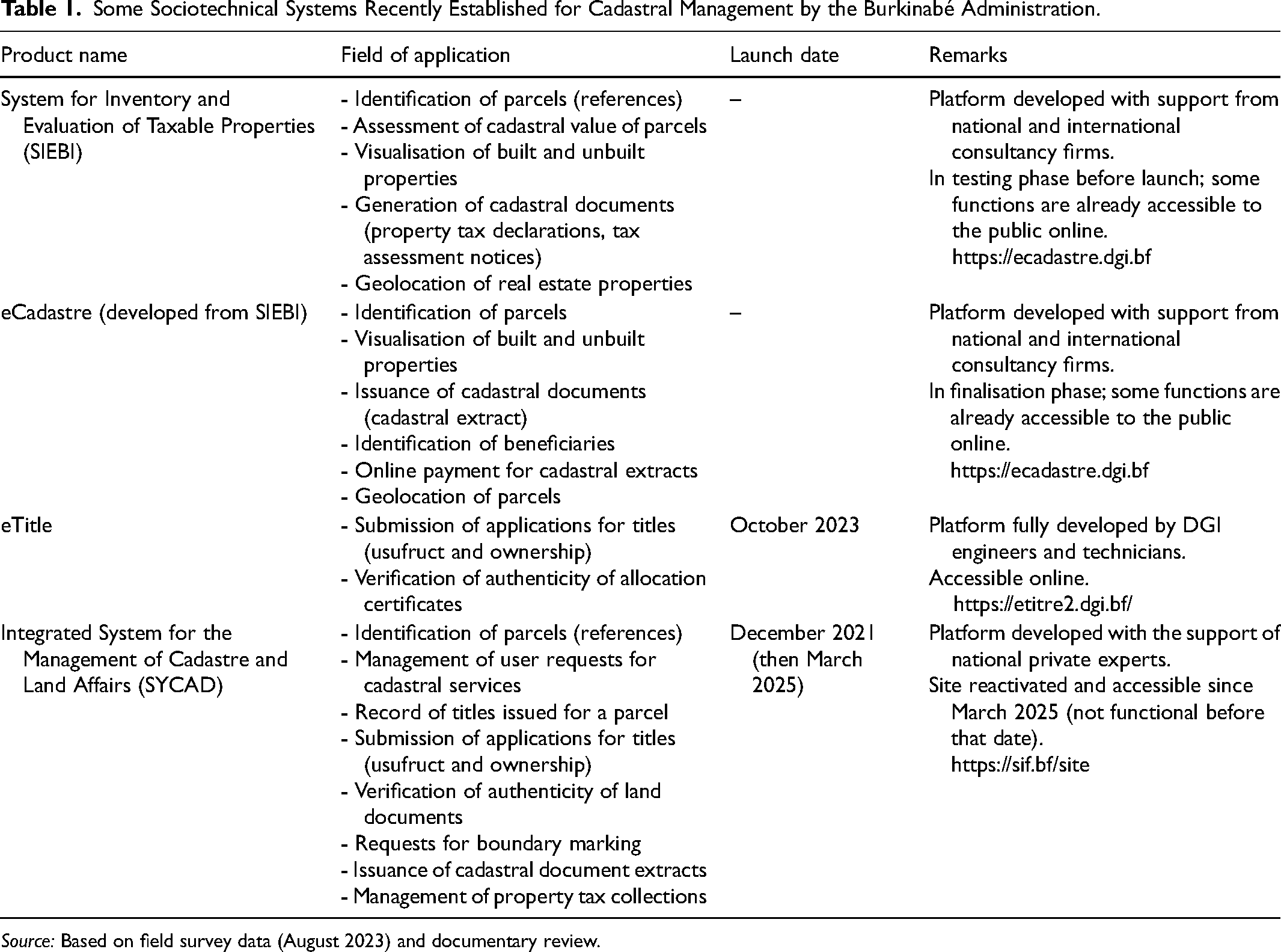
Source: Based on field survey data (August 2023) and documentary review.
The development of these platforms is part of the process of establishing a Land Information System (SIF) that integrates all the institutions involved in land management in Burkina Faso and enables all users to access cadastral information. The applications of these platforms constitute an essential link in the integrated land information system.
Starting with the SIEBI application, the main objective is to remotely assess, through geolocation, the cadastral value of a parcel for an identified owner or user. The eCadastre application allows a user to submit a request for a cadastral extract and to pay for the service online. The eTitre system enables users to submit applications for property titles (usufruct or ownership titles) or to verify the authenticity of an allocation certificate. As for the SyCaD platform, it combines the technical functionalities of the other applications while providing the option to consult the history of land rights transactions on a parcel and to submit various types of requests (e.g. for boundary demarcation or for a land title).
These platforms are currently being developed by the consulting firms or technicians who designed them (both national and international experts). At the same time, they are gradually being adopted by the in-house technicians of the national institution responsible for cadastral management in Burkina Faso. The data collected or processed by these platforms will be stored internally on its servers.
These systems have attracted the interest of cadastral service agents as well as users (citizens, banks, and insurance companies). Already, the SyCaD platform enables users to benefit from the services offered. However, its functionalities are limited to a few localities and cadastral sections for which parcel maps and ownership information have been digitised. At the current stage of operation of these platforms, the available data do not yet allow for a precise analysis of their effectiveness or their social uses. In principle, any user can benefit from the services provided by these platforms, but it is important to take into account that access to the Internet and to smartphones or computers remains a constraint for segments of the population with middle or low incomes.
Rationalisation Tensions in the Cadastre
The digitisation of the cadastre generates tensions related to rationalisation. These tensions manifest, on the one hand, in a discrepancy between the objectives and the means required for this digitisation, and, on the other hand, in divergent operational logics and difficulties in collaboration amongst the state's technical departments.
Discrepancy Between the Objectives and Means of Cadastre Digitisation
The digitisation process aims to optimise the production of cadastral documentation, to dematerialise this documentation, to improve its archiving and preservation, and to contribute to the establishment of a land information system. The ultimate goal is to create a single, digital cadastre. The various actions undertaken by the state are broadly aligned with this goal. However, this goal is difficult to achieve with the means and approach adopted. A comprehensive digital cadastre relies a priori on the existence of a comprehensive cadastre, something Burkina Faso does not yet possess.
One of the first steps in generating a cadastre is the subdivision of municipalities. Once the boundaries of a territory are known, subdivision constitutes a primary step in the establishment of a cadastral plan. The sections obtained from this subdivision are then divided into blocks and parcels, producing chronological series of “section,” “block,” and “parcel” numbers. A cadastre cannot be established unless the subdivision of all municipalities has been completed, and Burkina Faso is characterised by a low level of subdivision of municipalities. Figure 1 shows the proportion of subdivided municipalities by region.
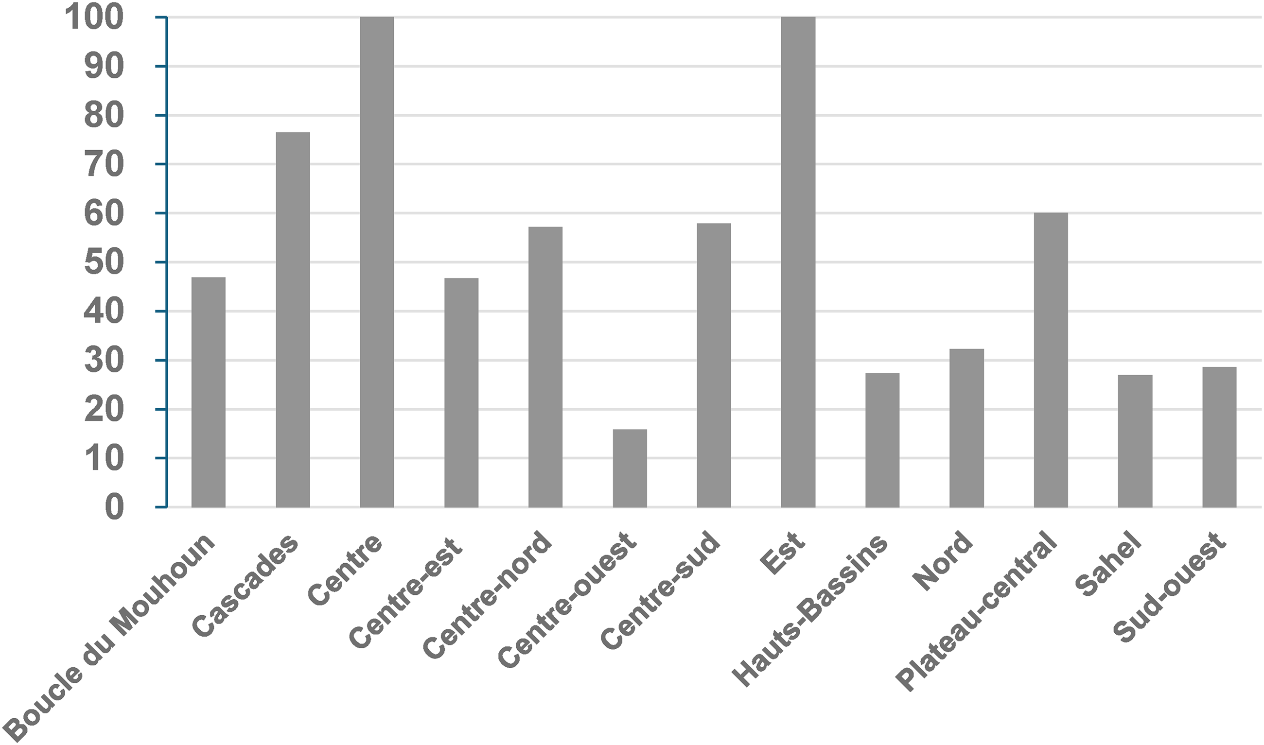
Proportion (in per cent) of subdivided municipalities in the regions of Burkina Faso.
Figure 1 shows that the Central Region, which includes the municipality of Ouagadougou, and the Eastern Region are the only regions where all municipalities have been subdivided. For the country as a whole, only 162 out of 351 municipalities or 46 per cent were subdivided in 2022. In other words, the subdivision of municipalities remains incomplete, making a comprehensive digital cadastre impossible. We note here that the objectives and purpose of digitisation are not aligned with the needed prerequisites or the necessary means – namely, the subdivision of all municipalities.
Logics of Action and Challenges in Collaboration Amongst State Technical Services
According to regulatory texts, several ministries, through their technical departments, play a role in the establishment of the cadastre. These include, primarily, the ministries responsible for the economy and finance, urban planning and housing, agriculture, livestock, fisheries, and the environment. In addition to these institutions, municipalities and private entities such as licenced surveyors and specialised consultancy firms are also involved.
The management of the cadastre (including the sectioning of subdivisions, preparation and updating of cadastral maps, and identification and updating of landholders) falls primarily to the ministry in charge of the economy and finance. Other entities, therefore, collaborate with this ministry in cadastral management. However, in the words of one civil servant, there are “sectoral cadastres in reality. Everyone rows in their own direction without looking at what the neighbour is doing, so pooling efforts is not always easy” (Interview with COS, Head of the IT Department, Ministry in charge of Cadastre and Land Affairs, 18 August 2023).
This situation arises from the fragmentation of land-related responsibilities across multiple administrative entities. Such fragmentation creates confusion regarding the limits of each institution's competence. Table 2 presents the mandates of the various institutions most directly linked to the cadastre.
Main Public Institutions Involved in the Establishment of the Cadastre and Their Mandates.

Source: Based on the legal governing sectoral ministries (Gouvernement du Burkina Faso, 2023a, 2023b, 2023c, 2023d) and the General Code of Local Authorities.
Although the areas of competence of the various ministries overlap, in matters relating to cadastral management and its digitalisation, any institution that produces cadastral information is required to share it with the Cadastral Directorate within the Ministry of Economy and Finance. This does not always occur. “The services of other ministries do not always transmit, in due time, to the cadastral service, the technical files concerning the land subdivisions they have carried out under their supervision” (Interview with BPA, Technical Manager in the structure responsible for cadastral management, 3 August 2023).
For example, in the area of urban planning, the Ministry of Urban Planning and Housing is responsible for approving subdivision plans, carrying out parcel boundary-marking operations, and supervising subdivision activities. These activities enable it to hold land archives (technical files on boundary marking and subdivision). In principle, the ministry should provide the information in its possession to the technical service responsible for cadastral management within the Ministry of Economy and Finance, for purposes of segmentation and/or integration of such information into the cadastral map. However, administrative bottlenecks and, above all, the difficulties encountered in certain subdivision processes (demand for plots exceeding supply, poor management of compensations, and so forth) mean that this information is not always transmitted immediately to the cadastral management office of the Ministry of the Economy and Finance.
Even within the Ministry of the Economy and Finance, collaboration challenges persist, insofar as “[its] cadastral services have the cadastral plan, and [its] revenue, land, and disclosure services hold the property file – that is, the list of beneficiaries […]” (Interview with OBO, Head of Service at the One-Stop Land Office, 11 August 2023). This situation has led some to observe that “the cadastral office [technical department] is running everywhere in search of data to computerise. All this is due to insufficient collaboration” (Interview with OBO, Head of Service at the One-Stop Land Office, 11 August 2023).
Such collaboration difficulties have long characterised the relationships between various organisations sharing competencies in land matters. They reflect the tension between what is formally prescribed in terms of prerogatives for each technical body and what is actually done in practice. Even if one cannot speak of competition between actors for control over cadastral matters, what emerges is that the body officially recognised as responsible for cadastral management, namely the Cadastral Directorate (in the Ministry of the Economy and Finance), struggles to assert its leadership vis-à-vis the other structures involved.
Initiatives have been undertaken to improve information sharing amongst the different stakeholders. The ongoing digitalisation of the cadastre constitutes a moment of truth that forces each institutional actor involved in cadastral construction to face their responsibilities. Thus, “when digitalisation [of the cadastre] was mentioned, we saw the Ministry of Urban Planning provide the cadastral service with data it could have provided long before” (Interview with GUS, head of a surveying firm, 19 August 2023).
In the absence of regulatory provisions (such as decrees or procedural manuals) that specify objectives, roles, and responsibilities; that clarify how things are to be done; and that strengthen the leadership of the primary structure responsible for cadastral management, the issues identified will inevitably persist.
Discussion
This study on the digitalisation of cadastral management raises questions about land governance in the digital era. Several key results emerge. Cadastral digitalisation can promote better land tenure security for holders of parcel land rights and enhance the disclosure of public information about land rights. Toward this end, several sociotechnical systems have been established in Burkina Faso, although they are not yet fully operational or accessible to the public. However, the digitalisation of the cadastre in Burkina Faso has generated tensions in the form of a gap between objectives and means, as well as difficulties in collaboration amongst the technical departments involved in building the cadastre. These findings point to several areas for discussion: the security of digital land registry data, land management as a space where conflicts and opposing interests play out, and the social anchoring of a digital cadastre.
Securing Digital Cadastral Data
The platforms currently being implemented for cadastral management are interfaces that enable users to access information about parcel holders, as well as about the status of rights over parcels or their fiscal value. The data behind this information have necessarily been recorded and stored through digital means such as computers, servers, or cloud systems, and digital networks facilitate access to this information and exchanges amongst users. Taken together, these interconnected elements form a digital space.
Yet, digital spaces have become the site of a new form of conflict marked by espionage and influence operations (Germain and Massart, 2017). Digital spaces are also characterised by illicit trafficking, destabilisation, and sabotage (Tisseyre, 2021). In this context, there is reason to fear that the digital platforms established for cadastral management in Burkina Faso could become targets of malicious attacks or data theft. Consequently, data security represents a major challenge for public authorities and for those managing these systems (Lagtati and El Hamel, 2025; Sylvestre, 2017).
The desire to secure digital data is subject to the material and technical capacities that Burkina Faso possesses in this domain. Regardless of improvements in the material capacities, Burkina Faso remains amongst the states that do not possess digital sovereignty (Germain and Massart, 2017). Since the digital space is characterised by the interdependence of its various components, including data, servers, networks, and software (Germain and Massart, 2017), Burkina Faso cannot be said to be autonomous in any of these technological elements. The country is almost entirely dependent on external sources for the provision of digital equipment and services. Nonetheless, human resources may offer an important tool for security. The local expertise available in the field of computing can, with strengthened technical capacities, ensure a relative degree of security for the digital data pertaining to the cadastre.
Land Management: A Field of Interaction and Expression of Antagonisms
As a matter of public policy, land management falls under the shared jurisdiction of multiple ministerial departments, each of which has broadly defined missions. Because of this shared competence, cadastral information is held by various bodies which do not always share this information in a timely manner. Consequently, the central structure responsible for updating the cadastral map often finds itself without up-to-date information. These difficulties in sharing cadastral data indicate insufficient cooperation amongst institutional actors (Durand-Lasserve, 1994). They reveal that the bureaucratic space of land management constitutes a field of forces or struggle in which actors confront one another according to their positions within the structure of the field, thereby contributing either to its transformation or its preservation (Bourdieu, 1994).
The digitalisation of the cadastre, as a rationalising activity, is not immune to the antagonisms or tensions it seeks to resolve (Freund, 1966). Such antagonisms arise from the multiplicity of possible evaluations of ends (Freund, 1966). Formal rules broadly specify the modalities of coordination and information exchange amongst the actors, thereby allowing cooperation and co-production of the cadastre in Burkina Faso. Nevertheless, there remain ambiguities and zones of uncertainty in these cooperative arrangements, which are exploited by actors to strengthen their room for manoeuvre within the field (Crozier and Friedberg, 1977). These dynamics generate tensions surrounding the concrete translation of administrative competences into effective land management.
The main issue in the bureaucratic field of land management concerns institutional leadership in defining, promoting, and implementing solutions to land problems. The Ministry of Economy and Finance currently plays a pre-eminent role in cadastral management, but other ministries involved, particularly the Ministry of Urban Planning, seek to reinforce their roles. Consequently, some actors aim to maintain the bureaucratic structure of cadastral management as it is, while others would favour transforming that structure so as to redefine institutional roles and competences.
In addition to national actors, international cooperation agencies (such as the World Bank and Luxembourg's Development Cooperation) are also active in this bureaucratic field, often providing financial support and technical assistance to projects aimed at modernising land administrations in Africa. Indeed, given the recurrent lack of state financing, land administrations have become increasingly dependent on funding from international donors (Razakamanana, 2022). This dependence, in turn, raises questions about the long-term sustainability of cadastral management modernisation projects.
The Social Embeddedness of the Digital Cadastre
The digitalisation of cadastral documents and processes is still in progress in Burkina Faso. The digital platforms presented in Table 1 serve as interfaces between cadastral administrations and users, designed to meet their needs in terms of procedural management, information, and administrative documents. Analysing the social embeddedness of a cadastre whose documents and processes have been digitalised thus involves examining the meaning such a cadastre holds for its users.
For public service users, the use of digital platforms requires at a minimum the possession of a mediation tool (smartphone, tablet, or computer), a connection to a high-speed Internet network, and constant access to a source of electrical power. The availability of these resources does not, in principle, pose a problem for institutional users such as banks, insurance companies, notaries, and public administrations. For these actors, there are no major constraints to accessing the digital platforms currently being implemented.
By contrast, low purchasing power, limited Internet bandwidth, and insufficient electricity supply constitute significant constraints to the use of these platforms by the general population (Bebey, 2023). In such a context, there is reason to fear that digital platforms may not be accessible to everyone and may not necessarily lead to new social practices (Miège, 2020).
For all users, including those whose access to digital platforms is assured, a key issue that may arise concerns their trust in the cadastre (Roy, 2011). According to Roy, trust depends on the integrity and accuracy of technical data, the fidelity of mapping to on-the-ground realities, the cost of services, the ease of update operations, and access to legal security. The potential of a digital cadastre to serve as a tool that strengthens land tenure security for parcel rights holders rests largely on the trust that actors place in it (Sibiri, 2022). Given the uncertain nature of this trust, the complete substitution of paper by digital systems in cadastral management is likely to take more time (Miège, 2020).
Conclusion
This article aimed to highlight the tensions generated by the digitalisation of cadastral procedures and documents in Burkina Faso. The theoretical framework of rationalisation tensions served as a guide for the research. A qualitative approach, based on interviews and documentary review, was applied.
The analysis of the data collected revealed that the digitalisation of cadastral procedures and documents raises issues related to land tenure security and the improvement of land disclosures. Digitalisation process manifests itself through the modernisation of technical means, the computerisation of parcels, built properties, and cadastral archives, as well as through the establishment of sociotechnical systems. On the one hand, this digitalisation has the potential to reduce the factors that lead to disputes over land rights on the same parcel. In addition, the digitalisation of these procedures and documents can facilitate access to information on the precise status of real rights over a parcel for the various actors involved (cadastral service agents, individuals, and private companies).
On the other hand, the findings show that, beyond the concrete actions undertaken, the process of digitalising cadastral procedures and documents generates tensions. One of these tensions stems from the gap between the objectives of digitalisation, namely the optimisation of cadastral documentation production, and the available means, particularly the low level of communal mapping coverage. Another relates to the lack of collaboration amongst state technical services regarding the sharing of cadastral documents and archives.
Ultimately, despite stakeholders’ keen interest in the ongoing digitalisation of cadastral procedures and documents, tensions inherent in the rationalisation of public cadastral management persist. These tensions reveal political and institutional challenges that public authorities must confront if they are to build a unified, digital cadastre adapted to the needs of the various technical services and users. An important step for the relevant authorities would be to develop a strategic document that could guide and coordinate the actions of all actors in the land management chain involved in establishing a digital cadastre in Burkina Faso. In this regards, future research could focus on a policy framework for the digitalisation of public services in Burkina Faso.
Footnotes
Acknowledgements
The manuscript was translated and edited by Martha Johnson with the support of ChatGPT and Claude AI.
Data Availability Statement
The data used in this article are mainly qualitative. It was collected through manual note-taking during semi-structured interviews with those involved in the digitisation of the land registry. The quantitative data used in the text are secondary. It comes from the report by the “
Ministère de l'économie, des finances et de la prospective (2022)
intitulé : Modernisation du cadastre au Burkina Faso : états des lieux et perspectives.” For these reasons, the author has no database to publish. If you have any inquiries, please refer to the relevant webpage: ![]()
Declaration of Conflicting Interests
The author declared no potential conflicts of interest with respect to the research, authorship, and/or publication of this article.
Ethical Approval and Informed Consent Statements
The author declares that all interviewees gave informed consent before the interviews. They were informed of the research objectives and provided their verbal consent before the interviews.
Funding
The author received no financial support for the research, authorship, and/or publication of this article.