
Abstract
Exposure science has developed rapidly and there is an increasing call for greater precision in the measurement of individual exposures across space and time. Social science interest in an individual’s environmental exposure, broadly conceived, has arguably been quite limited conceptually and methodologically. Indeed, in social science, we appear to lag behind our exposure science colleagues in our theories, data, and methods. In this article, we discuss a framework based on the concept of spatial polygamy to demonstrate the need to collect new forms of data on human spatial behavior and contextual exposures across time and space. Adopting new data and methods will be essential if one wants to better understand social inequality in terms of exposure to health risks and access to health resources. We discuss the opportunities and challenges focusing on the potential seemingly offered by focusing on human mobility and, specifically, the utilization of activity space concepts and data. A goal of the article is to spatialize social and health science concepts and research practice vis-à-vis the complexity of exposure. The article concludes with some recommendations for future research, focusing on theoretical and conceptual development promoting research on new types of places and human movement, the dynamic nature of contexts, and training.
When we elect wittingly or unwittingly, to work within a level . . . we tend to discern or construct—whichever emphasis you prefer—only those kinds of systems whose elements are confined to that level.
Despite the new ranges created by improved transportation, local government units have tended to remain medieval in size.
A detective investigating a crime needs both tools and understanding. If he has no fingerprint powder, he will fail to find fingerprints on most surfaces. If he does not understand where the criminal is likely to have put his fingers, he will not look in the right places. Equally, the analyst of data needs both tools and understanding.
When we observe the environment, we necessarily do so on only a limited number of scales.
There is a desperate need to develop methods with the same precision for an individual’s environmental exposure as we have for an individual’s genome. . . . Even a partial, targeted understanding of exposure can provide substantial advantages.
Researchers have long suspected that where you live in addition to who you are may affect your attitudes, behaviors, and health (Kawachi & Berkman, 2003). Open almost any journal in any social science and health discipline within the past decade and you will likely find an article on multilevel modeling applications exploring the relations between place and health. “Putting people into place” is a research trend facilitated by the advent of new methods, software, and data availability (Entwisle, 2007). Researchers’ collective knowledge base regarding place effects on human health and well-being has contributed a new understanding on a range of outcomes related to health status, stress, cardiovascular disease, asthma, obesity, and mortality as well as on adolescent risk-taking behaviors and educational attainment. While specific place effects—almost regardless of the outcome studied and the population of interest—are often found to be small, the general finding is that place seems to matter and that the persistence of these effects describe, and may even exacerbate, spatial inequalities in health.
As we will argue, however, the conventional approach researchers have used to put people into place is fundamentally quite narrow, and this may act as a constraint on investigations on the usual social, economic, demographic, and health outcomes of interest and, by extension, how we define, measure, and understand social inequality. Specifically, we argue that if we are to better understand the outcomes of interest to social and health scientists, we also need to think more creatively about the complexity and heterogeneity of human mobility and individual exposure to risks and access to resources across time and space. We argue that this kind of perspective is increasingly necessary as the human scale of activity no longer appears to coincide with the local scale of the residential neighborhood (Basta, Richmond, & Weibe, 2010; Chaix, 2009; Cummins, 2007; Keller, 1968; Zenk et al., 2011).
Our main goal is to stimulate a discussion on next-generation measures and methods and to spatialize existing approaches to the study of people and places. Our general framework is one that focuses on spatial polygamy and contextual exposures (SPACEs). Spatial polygamy is the simultaneous belonging or exposure to multiple nested and non-nested; social and geographic; real, virtual, and fictional; and past and present contexts (Matthews, 2011). To demonstrate the conceptual value of a SPACEs framework, we will describe in lay terms contemporary approaches to measuring contexts and contextual exposures. This will be accompanied by a review of empirical examples drawing on different disciplines, substantive foci, data, and methodologies that collectively should give pause for thought regarding the definition and operationalization of place most commonly encountered in the social science and health literature. In this article, we focus on data and methods for the study of human mobility and their activity spaces. Activity space approaches are gaining traction, and their critical use may help spatialize both our theories and our research practice and may help reduce exposure misclassification (Basta et al., 2010; Chaix, Merlo, Evans, Leal, & Havard, 2009; Cummins, 2007; Cummins, Curtis, Diez-Roux, & Macintyre, 2007; Diez Roux, 2001, 2003; Kwan, 2012; Matthews, 2011; Rainham, McDowell, Krewski, & Sawada, 2010; Zenk et al., 2011). Across the social and health sciences, we have an ever-expanding arsenal of data collection methodologies, and these ought to be harnessed to fill some theoretical gaps. The article closes with some recommendations for future research priorities.
Spatializing Research on Place
In exposure science, a relatively new term is exposomes, which refers to the compilation of exposures experienced over an individual’s lifetime (Wild, 2005). As noted in the opening quote from Christopher Wild, we need better precision in the measurement of individual exposures coupled with spatial and temporal precision. In a world of “big data,” “volunteered information” (e.g., Facebook, Twitter), biomarker data, real-time tracking, surveillance and other sensor data, and smartphones, this idea of compiling intensive longitudinal data on individuals has traction (Borrell, 2011); this is especially the case in studies of movement, networks, and interactions (see González, Hidalgo, & Barabási, 2008; Palmer et al., in press; Raento, Oulasvirta, & Eagle, 2009).
While several disciplines can all lay claim to an interest in tracking an individual across different parts of a broadly defined exposome (or life path), most academic fields focus almost entirely on the temporal and rarely the spatial dimension. For example, across the social sciences, we can readily find traditional areas of research on individuals focusing on the sequencing of events (e.g., migration histories), durations (e.g., job retention, cancer survivorship), and transitions (e.g., entry in to marriage, the labor market, or retirement). Similarly, we see a focus over time on social groups (e.g., changes in collective behavior, social movements) and even places (e.g., demographic and epidemiological transitions, industrial restructuring, studies of policy change and place-specific interventions, and in the response to natural disasters, such as hurricanes). This temporal focus on individuals has looked at short periods of time, such as a single day (e.g., commuting, divisions of labor in the home, exercise and physical activity), slightly longer temporal scales to study transitions (e.g., entry to and exit from school, work, family formation, or retirement) and to the study of, in theory, entire lives via birth cohort studies—though the latter to date have only begun to scratch the surface of a total exposome. While some of this work has paid attention to geographically referenced information, the majority of the work is aspatial. That is, the integration of the temporal with the spatial and the study of the reciprocal relationships between people and places over time are still rare and, when it occurs, often examines but a single slice of time and space (e.g., in many multilevel studies, the data on both people and places are cross-sectional, although multilevel models are capable of dealing with longitudinal data).
Places as an Isolated Jigsaw Piece
Simon Levin in his 1989 MacArthur Lecture discussed at length the “problem of pattern and scale” in ecology. He stated, a now often repeated comment, that “there is no single ‘correct’ scale on which to describe population or ecosystems” (Levin, 1992, p. 1944). That is, there is no correct scale to measure place. So while sociologists, public health scientists, and many others besides “have treated ‘neighborhood’ in much the same way as courts have treated pornography: a term that is hard to define precisely but everyone knows it when they see it” (Galster, 2001, p. 2111), there has been a fetish for the residential neighborhood to be used as the single correct scale in our exploration for neighborhood effects. The first cut as to how to define residential context is often based on disciplinary theories, the variables salient to the outcome of interest, data availability, and their format. Data availability and format are an important reason the majority of the published empirical research examining the role of place-based contexts uses the residential neighborhood as defined by a census unit, typically a census tract. However, we are beginning to see the emergence of distance- and network-based buffers being used to define residential neighborhoods. Indeed, physical activity researchers with their focus on built environment characteristics have been quick to embrace new measures and data formats—specifically, point, route, and raster or grid data sets—and as such have begun to see the world as “more” continuous than those fields more used to the discrete polygon views of the world. That said, in a review of cardiometabolic risk factors, Leal and Chaix (2010) found that over 90% of studies solely focus on one environment, the residential environment, and 73% rely on a predefined administrative neighborhood as the statistical unit of choice. We might add that given the relative lack of data on residential histories, our tendency is to put people only in their current place (Kemp, 2011), though there have been several recent exceptions (Crowder & South, 2011; Sampson, Sharkey, & Raudenbusch, 2008; Timberlake, 2007; Wodtke, Harding, & Elwert, 2011).
There are many legitimate questions we ought to be asking regarding the use of residential neighborhoods to define the social, built, and physical environment contexts to which our study populations are exposed (Frumkin, 2006; Macintyre, Ellaway, & Cummins, 2002; Matthews, 2008, 2011; Mitchell, 2001). Some of main questions are as follows: What is the size of the residential neighborhood? Do residential neighborhoods adequately capture the processes that “get under the skin” (Taylor, Repetti, & Seeman, 1997)? Do the residential neighborhoods have meaning to the individuals we study? Do the residential neighborhoods capture, contain, or bound human spatial behavior?
As a simple illustration of how 90% of the social and health literature on neighborhood effects conceptualize residential neighborhood, consider Figure 1. This figure is motivated by the innovative work of the French artist Armelle Caron in a series called Anagrammes graphiques de plans de ville, 2005/2008. Caron displays two “maps” side by side; one is a real city map while the other resembles jigsaw pieces arranged by size for that same city. Figure 1a is a mock-up of parts of Manhattan, New York (dark gray), and parts of both Queens and Kings (Brooklyn), New York (light gray), and the East River. The jigsaw pieces are approximate representations of local places or residential neighborhoods. Putting people into place in a standard two-level multilevel model requires that we embed an individual (Level 1) within a residential neighborhood (Level 2). This embedding of an individual within a single neighborhood disregards the absolute and relative positioning of the neighborhood, and this approach is akin to the representation of places in Figure 1b. This dominant perspective implies that the social, built, and physical environment attributes and the processes we seek to understand are modeled as discontinuous processes. As Fotheringham, Brunsdon, and Charlton (2003) state, “it is assumed that the process is modified in exactly the same way throughout a particular spatial unit but that the process is modified in a different way as soon as the boundary of that spatial unit is reached” (p. 19). In this, our standard multilevel conceptualization of the real world, human behavior matters most within a single residential neighborhood level.
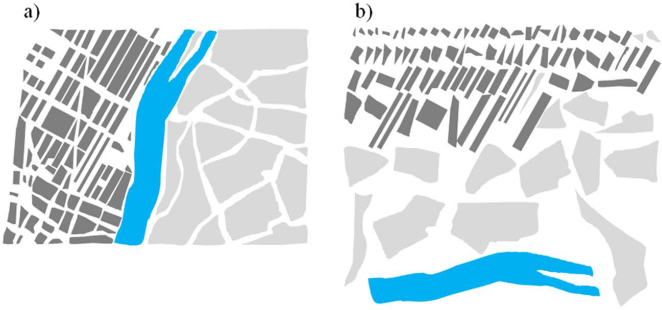
Some neighborhoods of Manhattan (dark) and Queens/Kings (light) (a) in crude map form and (b) as they are conceptualized in a multilevel model.
Embedded Places
Frequently in our research, the embeddedness of the single neighborhood itself within a collection of neighborhoods or other nested and non-nested units are ignored. The “real” residential neighborhoods are not isolated islands; rather, they are connected to other neighborhoods, and they are embedded within larger contexts that remain undefined, unmeasured, and unexamined. For example, the Atlanta-Sandy Springs-Marietta metropolitan area has 690 census tracts that are neatly nested within 28 counties, but these same tracts also fall within 162 census places, 125 subcounty units, and 82 school districts. Note also that census tracts are not always neatly nested within higher levels, some of which have more functional relevance than others to their residents because of both service provision and financial obligations relationships between people and place (i.e., urban places and school districts).
Some researchers have looked at adjacent or proximal census tracts, compared two definitions of place, or explored the use of clusters of census areas to create homogenous neighborhood units, but their numbers are few (Chaix, Merlo, & Chauvin, 2005; Chaix, Merlo, Subramanian, Lynch, & Chauvin, 2005; Crowder & South, 2008, 2011; Hipp, 2007; Mobley, Kuo, & Andrews, 2008; Morenoff, 2003; Sampson, Morenoff, & Earls, 1999; South & Crowder, 2010; Yang & Matthews, 2010). Inagami, Cohen, & Finch (2006) is held up as one of the few health studies to explicitly look at extralocal effects—in neighborhoods where people shopped—as well as within residential neighborhoods. While there are examples of three-level data structures (e.g., nested predefined units, such as people within census tracts within counties) it is still rare that we explore linking individuals to multiple, hierarchically nested, or hybrid places.
As has been implied, the definition of residential neighborhoods (and the measurement of attributes within these units) is not benign (see also Feng, Glass, Curriero, Stewart, & Schwartz, 2010). Research findings on place effects may be dependent on the criteria used to define residential neighborhoods. Standard statistical techniques, such as correlation and regression, are sensitive to the choice of units of analysis. In a classic study, Openshaw and Taylor (1979) demonstrate that the correlation between two variables can be estimated to be anywhere between −1 and +1, depending on spatial units used. In an equally sobering study, Fotheringham and Wong (1991) explored the use of multivariate techniques at different scales and provide an account of the effects of the modifiable areal unit problem (MAUP). Specific to health research, Flowerdew, Manley, and Sabel (2008) demonstrate how results can vary dependent on how neighborhood boundaries are drawn. Flowerdew and colleagues compared existing neighborhood boundaries to five realistically defined pseudo areas (i.e., based on criteria such as total population, compact shape, and internal homogeneity), and along with others looking at MAUP issues, their findings reinforce the need to think about the geography of “effective” neighborhoods prior to analysis and also to experiment with different scales and aggregations (see also Mobley et al., 2008; Riva, Apparicio, Gauvin, & Brodeur, 2008; Spielman & Yoo, 2009).
Places and Time Geography
Getting researchers to think about the geographical scale of the processes behind the outcomes of interest should not be a challenge, but more often than not, researchers do not even take the first required step: to map the boundaries of the neighborhoods of the people they are studying. The lack of attention to the geographic footprint of census tract boundaries and how they invisibly dissect everyday life is particularly curious given what we know about the varying facets of everyday life (Golledge & Stimson, 1997). For most people, exposure to specific places is bimodal in time and space, with clusters of time spent and activities found around specific hubs or nodes (polycentric exposures), and we are attached to multiple places in time and space (spatial polygamy); for example, consider Figure 2. In this representation, time spent in place is implicit in the relative thickness of the lines representing journeys of activities. The most frequent journey is the commute to work, but other nodes or anchor points (e.g., the mall, a grocery store) also serve to take this individual to other nonresidential places. Although not shown in Figure 2, the geographic size and configuration of residential neighborhoods is an important dimension of exposure studies. In this representation, the journeys take the individual up to 8 to 10 road miles from home. It is worth noting that on average, census tracts, especially in the center of large urban areas, are typically quite small and often cover less than one square mile (while suburban and rural census tracts can be geographically quite large). This may sound like a large area for a residential neighborhood, but census tracts are frequently irregular in shape, and the census tract footprint does not always capture the spatial behavior of residents during the course of a typical single day. As such, traditional studies of place all too easily ignore the nonresidential neighborhoods and places that people are exposed to during their daily activities (let alone their activities collated across other temporal windows, such as a week, month, year, or lifetime).
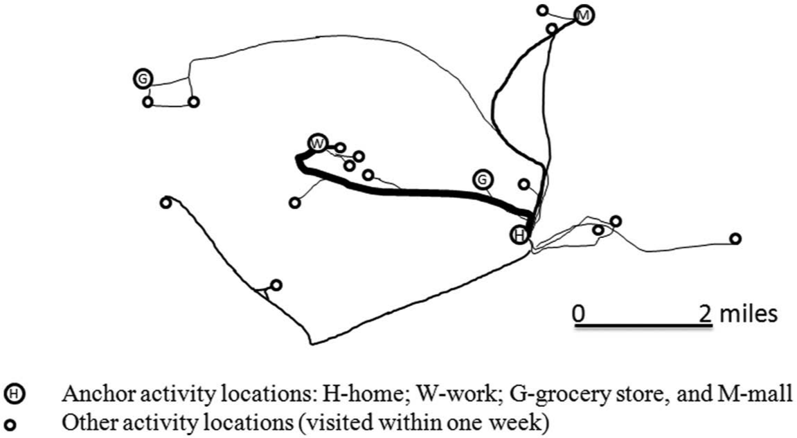
A hierarchy of movements in an individual’s activity space.
The data in Figure 2 represent just a single individual so let us look at some data on the mobility of larger numbers of people over different temporal and spatial scales. To illustrate the pervasiveness of non-residential movements we will consider data from different sources: censuses, surveys, feasibility studies, and ethnographic studies. But before we do this it is important to acknowledge the established literature on the spatial dimensions of daily life (Golledge & Stimson, 1987). Studies of “time geography” date back to the 1960s and 1970s, emerging from the Lund School in Sweden (Carlstien, Parks, & Thrift, 1978; Hägerstrand, 1967, 1970; Pred, 1977). The Lund School developed models that look at constraints on human behavior (or activities) within a time-space prism that serves to bound or define action spaces where constraints on movement in time and space can be used to identify what has been referred to as potential path spaces (Kwan, 1999; Miller, 1991). Time or time-space geography reemerged as an important area in the field during the early 1990s with an infusion of work by several geographers, including feminist geographers (e.g., Rose, 1993) who explored the variability in geographical range and footprint of activity spaces among groups of women. In particular, researchers were interested in studying patterns of spatial entrapment, the constraints of double-day activities, and the set of other spatial and temporal constraints on their lives (Friberg, 1993; Hanson & Hanson, 1993; Laws, 1997; Tivers, 1985). It is these types of constraints on human behavior that are inescapable for some populations, but these types of mobility comparisons are rarely incorporated into social science frameworks. In the past decade, Kwan has been the leading proponent of activity space research initially based on the use of transportation survey data (Kwan, 2000, 2004; J. Lee & Kwan, 2011), then later in mixed-method research and qualitative geographical information systems (GIS; Kwan & Ding, 2008).
Mobility and the Dynamics of Place
What do we know about human mobility, spatial polygamy, and contextual exposures? Let us open our discussion by switching the focus to migration. According to the U.S. Census Bureau’s (2011) Current Population Survey, between 2010 and 2011, approximately 12% of the U.S. population—or 35 million people—moved residence. Among these people, two thirds moved to a new residence in the same county, and the remaining third were almost equally split between within-state moves and moves to other states or abroad. There are age-specific, work, and education dimensions that generate variation in migration rates by population subgroups, but the main point we wish to make is that even long-distance moves or relocations are common. Many demographers lament the lack of high-quality data on migration, but it is clear that if we are to understand exposomes, we need detailed lifetime residential histories.
What do we know about commuting behaviors and other types of journeys? There are several different ways to think about daily movements. We will start by comparing nighttime and daytime populations, specifically via the use of employment-residence ratios (E/R ratios). In 2000, 73% of workers lived and worked in the same county (U.S. Census Bureau, 2000). When we look at this at different scales, the flows of people in and out of places changes the stock and the composition of the populations in both the origin and destination place, and these changes can be quite dramatic. For example, in 2000, New York County (Manhattan) had a net gain of 1.3 million workers per day and an overall E/R ratio of 2.78, the District of Columbia gained 400,000 workers per day for on overall E/R ratio of 2.57, and in total, 22 counties gained over 100,000 workers per day. Conversely, “bedroom” counties on the edge of metropolitan areas have low E/R ratios (e.g., Livingston Parish in the Baton Rouge area and Pauling County in the Atlanta area both lose approximately 25,000 workers per day and have E/R ratios of 0.41 and 0.36, respectively). Six counties lost over 100,000 workers per day (Bronx, Kings, Queens, and Suffolk counties in the New York area; Prince George’s, Maryland, near Washington, D.C.; and Contra Costa, California, near San Francisco and Oakland), and another 21 counties lost over 50,000 workers. Most but not all counties adjacent to large population hubs had a net loss of daytime workers (e.g., DuPage, Illinois, had a net gain of 65,000 workers for an E/R ratio of 1.14). As we change scale to look at urban places and to potentially still smaller geographical units, the E/R ratios exhibit substantial heterogeneity. Urban places with edge city mall areas, technology parks, and commercial centers can see dramatic net gains in workers and thus high E/R ratios. For example, in 2000, the Tysons Corner census-designated place in Virginia had a resident population of approximately 18,000 and an estimated daytime population of over 72,000, generating a net increase of over 54,000 workers and an E/R ratio of 5.78. We will return to a discussion of the need to pay attention to the dynamics of context in our recommendations.
Places and Noncommute Routines: The Loosening of Dependence on Residential Place
Now let us look in more detail at individual trips. Golledge and Stimson (1997) report that U.S. studies found that 25% of all trips are from one out-of-home activity to another, raising issues of the importance of not just relative distances from home but also the distances between other sets of activities. As Golledge and Stimson also noted, trips or journeys have characteristics other than distance traveled. Some trips are regular (e.g., grocery store, work, or place of worship), others are irregular (e.g., some social trips or nonscheduled health trips), and some types of trips are more likely to be completed in a multipurpose or sequenced manner (e.g., grocery store and other shopping activities), to occur at different times of the day or day of the week, and to vary in the mode of transportation used and the time taken. In addition, the origins and destinations of trips have attributes, too (e.g., the most frequented grocery store may not be the cheapest and/or sell the most diverse quality of produce, a friend’s home may be adjacent to a park, or a workplace may provide day care). These types of travel pattern observations, trip characteristics, and origin and destination attributes have been well known in behavioral geography and transportation research for some time, but it is only recently that researchers in other areas (e.g., obesity researchers) have started to pay attention to distances traveled (see Kerr et al., 2012; Zenk et al., 2011).
Given what we know about residential exposure from censuses and transportation surveys, what is presented below—based on different research topics, research methods, and kinds of data—should not come as surprise. We suggest that the cumulative evidence from this body of research points to a loosening of the dependency on residential place.
Some ethnographic, small-sample, and feasibility research has found considerable variation in people’s movements and their utilization of nonresidential spaces (Kwan & Ding, 2008; Matthews, Detwiler, & Burton, 2005). For example, most recently, Matthews (2011) reported on data on 42 low-income families in an urban setting and found that the percentage of functional ties to specific named places that were in the home census tract was just 6% of the total, with an additional 20% located in adjacent tracts and the remainder located elsewhere in the city. While there was variability by domain of life (work, school, health, and family) and residential area, the overall pattern held up. In a rural study, Matthews and Shoff (2011) also found that the spatial range of families varies, but in many cases, families’ daily activities and functional ties extend well beyond their residential tract, beyond their town, and beyond the county of residence (the E/R ratio and functional dependence between rural places and small towns is a partial explanation).
Basta et al. (2010) found that hand-drawn neighborhoods and activity paths did not correspond to census tract boundaries among a small sample of 15- to 19-year olds. In fact, in no instance did the hand-drawn areas correspond to one of five administratively defined boundaries the researchers considered as identifying the local neighborhood (block, block group, tract, ZIP code, or local municipally defined neighborhood). Basta and colleagues found that mean time spent outside of the residential census tract exceeded 6 hr, and on average, 71% of the time spent outdoors was outside of the residential census tract. They also noted that an individual’s activity path intersected with an average of 8 census tracts. At the other end of the age spectrum, Yen, Shim, and Martínez (2012) interviewed 38 adults (ages 62 to 85) in the Bay Area and found that older people value mobility and that those who are able to engage in activities outside their immediate residential neighborhoods.
Places, Obesity, and Health Exposomes
Activity space perspectives have started to emerge in obesity research because they provide the explicit link between a physical activity or food consumption and contextual exposure. For example, a key question is where is the physical activity, specifically, moderate-to-vigorous physical activity (MVPA), taking place? Is it in the residential neighborhoods (defined as a census tract, street network, or radial buffer) or in other places, such as at school? Rainham et al. (2012) utilized global positioning systems (GPS) and accelerometer data to examine the physical activity by specific activity location site and level of urbanicity among adolescents. What is particularly interesting about this study is not just the multiplicity of places where some form of MVPA occurs but that the journeys between locations accounted for the majority of MVPA. Indeed, journeys were more important than either the home residence or school environments. As we noted earlier in regard to trip patterns, Rainham and colleagues found that journeys were to multiple places not just between home and school and that these adolescent journeys took them to locations “well beyond those typically used to derive buffers or other measures of proximity” (Rainham et al., 2012, p. e-93). In an earlier study based on adults, Troped, Wilson, Matthews, Cromley, and Melly (2010) found that more than 60% of MVPA occurs in locations more than 1 km from home or work locations.
Other obesity researchers have looked at food consumption. For example, Zenk et al. (2011) used GPS data to recreate activity spaces on a sample of 120 women in Detroit. Activity spaces were generally larger than residential neighborhoods. Importantly, Zenk and colleagues found that environmental features of residential neighborhoods and activity spaces were weakly associated but that some activity space environmental features were related to dietary behaviors. This implies that the environmental features of the residential neighborhood are a poor proxy for those places to which individuals were exposed through the course of their day-to-day activities. More recent studies confirm the tendency to underestimate true food environment exposures. Kerr et al. (2012) studied 4,800 adults and almost 12,000 food-related trips in Atlanta and found that people travel sizeable distances for food and that they also purchase food while traveling from locations other than home. In another study, Kestens et al. (2012) examine the association between activity space exposure to food outlets and risk of overweight in men and women in Montreal and Quebec City. They found that estimates of food environment exposure that accounted for both residential and nonresidential destinations were significantly and more strongly associated with overweight than were residential-only measures of exposure for men, while residential exposures were more strongly associated with overweight than were nonresidential exposures in women.
Activity space approaches have also been used to look at other health outcomes. Vallée, Cadot, Roustit, Parizot, and Chauvin (2011) examined the role of daily mobility in mental health inequalities in a sample of approximately 3,000 Parisians, of which over 80% had an activity space larger than their perceived neighborhood. Vallée and colleagues found a cross-level interaction between activity space and neighborhood deprivation such that living in a deprived neighborhood had a stronger and statistically significant effect on depression among people whose activity space was confined to their neighborhood compared to those engaged in extralocal activities. Among people residing in an advantaged neighborhood, a limited activity space was a protective factor.
A seemingly consistent finding across studies adopting an activity space perspective is the variability in individual activity spaces, even for people in the same residential neighborhood, but also that this variability may be structured along gender, racial-ethnic, and socioeconomic lines. That is, some populations appear spatially entrapped (cf. the spatial entrapment literature cited above).
Place Perception
There is an established literature on mental maps, place perception, and the meaning of place (Lynch, 1960; Tuan, 1977). Place perception is important as “we live in a continuous world not one bounded by arbitrary (not always objective) boundaries, and we also live in an anisotropic world in which knowledge and movement are easier in some directions than in others” (Matthews, 2012, p. 518). When we study people living in the same place, we typically find heterogeneity in how individuals think about place. For example, within sociology, Coulton, Korbin, Chan, and Su (2001); Furstenberg, Cook, Eccles, Elder, and Sameroff (1999); B. Lee and Campbell (1997); and Sastry, Pebley, and Zonta (2002), among others, have all observed that individuals living in close proximity to each other and sharing similar socioeconomic and demographic characteristics do not share a common definition of their residential neighborhood. Interestingly, an individual’s own definition of his or her residential neighborhood also may change over time. Again for disciplines that study transitions, it should come as no surprise that the definition of a residential neighborhood of a young girl may be different for that same person as an adolescent, at middle age, or in old age as her spatial knowledge and boundaries expand (or even contract). Paralleling our focus on objectively measured activity spaces, using GPS, we believe it is critically important that, where possible, researchers also collect information on perceptions of place(s); that is, measuring environmental features within a perceptual space may offer a more accurate and comprehensive characterization of environmental exposures than doing so solely within an administrative unit (see Vallée et al., 2011; Vallée, Cadot, Grillo, Parizot, & Chauvin, 2010).
New Data and Technologies for Studying Place, Mobility, and Exposomes
Recent research points to a new generation of activity space studies that couple technologies—accelerometers, GPS, and smartphones—to engage in continuous monitoring of people in places (heart rate, physical activity, physical location) and/or ecological momentary assessments of self-report measures of psychological health at specific times and places (for applications in sociology and demography, see Palmer et al., in press; Raento et al., 2009).
There have been recent developments in processing and analysis software that can facilitate activity space research. The Physical Activity and Location Measurement System (PALMS) is designed to integrate GPS, accelerometers, heart rate monitors, and cell phones and is being used by exposure biology researchers measuring physical activity as a function of time and location (Patrick et al., 2008; and see http://ucsd-palms-project.wikispaces.com/). Another methodologically innovative project is the Residential Environment and Coronary Heart Disease (RECORD) Cohort Study (see http://www.record-study.org). RECORD is epidemiological study of over 7,000 Parisians and their neighborhoods designed in part to investigate how environmental exposures contribute to health disparities between individuals, groups, and areas (Chaix et al., 2012, in press). Similarly, several research groups have developed software and approaches to help manage and visualize time-space data, and these have been coupled with GIS software. For example, Shaw and colleagues (Chen et al., 2011; Shaw & Yu, 2009; Shaw, Yu & Bombom, 2008; Yu & Shaw, 2008) have developed exploratory spatial data analysis tools for studying activity spaces, applying them to long-distance migrations and also local scales.
One of the most exciting new sources of potentially useful geospatial data is a rapidly growing area known as volunteered geographical information, or VGI (Goodchild, 2007). VGI is the creation of data by citizen scientists and volunteers (crowd sourcing) often using mobile technologies and sensor devices. Currently it is an open question on how these forms of data can be leveraged, but these new data have the potential to fundamentally change the quality, scope and flexibility, and timeliness of measures of our social, built, and physical environments (Elwood, Goodchild, & Sui, 2012). Perhaps the best-known geospatial VGI product is www.openstreetmap.org, and for some purposes, these data may well be better suited than other existing, often commercial, databases to “measure” places, but more validation work must be undertaken to check on the accuracy of context, positional precision, and geographical coverage.
Spatializing Place: A Summary
The patterns of association among different individuals and groups of people with place suggest that use of restricted definitions of place (i.e., residential neighborhoods) is missing part, and often significant parts, of the narrative on the connections between people and place. We believe that if we are to better understand the nature of the relationship between place and health, more attention must be paid to the scale of human behavior and specifically their activity spaces and also to the dynamics of contextual change; that is, we must examine spatial polygamy and relevant contextual exposures. The analysis of activity space environments will allow researchers to think in a more spatially sophisticated manner about the linkages between inequality and the conditions of contextual environments, namely, how the conditions within one’s activity space shape both exposure to risks and access to resources and opportunities. It may be that an activity space and SPACEs perspective can help facilitate our understanding of the geography of “winners” and “losers,” in terms of both people and places. For example, as some of the work cited above has indicated, research often finds variability in activity spaces based on gender, race-ethnicity, and socioeconomic status and in their combination (see Friberg, 1993; Gilbert, 1998; Hanson & Johnston, 1985; Kwan, 1999). As has been implied, stronger associations between neighborhood characteristics and health seen among women may be due to the fact that women spend more of their time in the neighborhood (Stafford, Cummins, Macintyre, Ellaway, & Marmot, 2005). That is, some women are spatially entrapped, and this may create opportunities of difference in terms of everyday access to child care, jobs, shopping opportunities, health care, and other services. An activity space perspective has the potential to help us better understand the variation in spatial inequality and social isolation between people residing in similar places.
Recommendations
The potential adoption of an activity space framework, attention to the definition of place, and consideration for scales of analysis are all important for research on place effects. While we do not anticipate large changes in how people study place effects, we do want to encourage new ways of thinking about place, how we operationalize place, and how we think about human spatial behavior over varying temporal and spatial scales. Paraphrasing Weisner (1996), we should avoid “methodocentrism” and the exclusive use of a specific framework, type of data, and analytical approach. The road forward is challenging and not without potholes and structural barriers. For the most part, research on health and place is stifled by the lack of high-quality and high-resolution historical data on places and their attributes and also because some types of places are often, relatively speaking, data poor (e.g., rural and/or remote areas and as is often the case in international contexts). Retrofitting past studies even with crude spatial and temporal data and attributes is challenging if not impossible. We cannot link an individual to the attributes of their residential place if attribute data were not, or are not, collected (or made available) or if geocodes for the individual were not collected. Similarly, we cannot explore the influence of nonresidential locations if questions were not asked and data were not collected. If we are to fully understand the individual and cumulative impacts of residential exposures, we need data on the duration, sequence, timing, and the location of all past residences (including data on immigrants, adding yet another dimension to the challenge). Ignoring or not collecting geographic identifiers means being unable to harness the geographical embeddedness of places or to position individuals within nonhierarchical or multiple-membership contexts, which eliminates, respectively, the possible consideration of extralocal effects and our ability to explore exposure misclassification. There are other challenges, too, that cannot be easily sidestepped, most notably, concerns over data validation (past, present, and future data), spatial uncertainty, and privacy. Prospective research on health and place has to face these challenges head-on, and as has been shown in some of the work summarized above, it is possible to design, collect, and analyze rich data on people and places, mobility, and activity spaces. Our overall thesis is that new scholarship on health and place will require synergies between theory, data, and method. In taking our next steps forward to spatialize the study of people and places in health research, we need to do the following.
Promote Conceptual Development
Theoretically, the potential relevance of higher-level contexts and macrolevel social processes to individual outcomes is widely recognized as evident in reports (National Academy of Sciences, 2006; Shonkoff & Phillips, 2000), conferences (Office of Behavioral and Social Sciences Research, 2000), edited volumes (Booth & Crouter, 2001; Burton, Kemp, Leung, Matthews, & Takeuchi, 2011; Galea, 2007; Kawachi & Berkman, 2003), and review articles (Leventhal & Brooks-Gunn, 2000; Taylor, Repetti, & Seeman, 1997). However, many of our conceptual models and frameworks are vague on place. For us, a significant missing piece is the explicit discussion of what the analytical level or levels and which spatial footprint is meant to capture the place or places that are thought to be relevant to the study of social and health outcomes. Frameworks for studying health and health disparities often refer to social environments; communities; neighborhoods; social, political, and/or economic conditions; policy environments; and environmental resources and constraints, but at what level are they defining place? And exposure? To paraphrase Galster (2001), “everyone seems to know what it is,” but operationalizing the right level or levels can be difficult. The model proposed by Glass and McAtee (2006) is among the more specific about nested levels and which “above-water” contexts or places we might focus on. While Glass and McAtee’s nesting of levels is primarily in the listing from micro to mezzo, macro, and global, they identify specific examples of analytical levels or places within each of their four supracontextual levels. Even here, though, we note that for the most part, these places and the attributes relating to risk regulation are often non-nested and may even be nonoverlapping geographically (e.g., residential tract, workplace, school district). As part of the next steps, we need to think clearly about how the multitude of places (spatial polygamy) are relevant to social and health outcomes and focus on improving our knowledge on how these places overlap in time and space to better determine appropriate definitions of place or places and any weighting schemes that we might use to study contextual exposures.
Study New Types of Places With New Methods
What we know about human spatial behavior suggests that focusing solely on residential neighborhoods ignores the human scale, relevant functional places, and other levels of analysis that may be more relevant to the social and health outcomes we study. The next steps include the search for more appropriate methods of analysis that do not depend so closely on the objects being analyzed (e.g., neighborhoods defined as census tracts or block groups) since the places are in most cases artificial and isolated constructs. This will include analyses that examine extralocal effects via the use of lagged variables in hierarchical linear models (see Crowder & South, 2011; Sampson et al., 1999) and, more specifically, spatial econometric approaches (LeSage & Pace, 2009), including the use of emergent methods, such as spatial Durbin models (Takagi, Ikeda, & Kawachi, 2012). We can also expect to see more use of innovative techniques that lie at the intersection of multilevel analyses and spatial analysis (Arcaya, Brewster, Zigler, & Subramanian, 2012; Chaix, Merlo, & Chauvin 2005). The adoption of multiple-membership models that permit assigning individuals to multiple non-nested contexts would also push the field forward (Browne, Goldstein, & Rasbash, 2001). There are several methods and techniques we have not discussed. These include the integration of social and spatial networks (Christakis & Fowler, 2007; Entwisle, Faust, Rindfuss, & Kenada, 2007; Larsen, Urry, & Axhausen, 2006) and complex systems tools, such as agent-based modeling (Epstein, 2006). Adler and Stewart (2010) have identified a newly emerging focus on interactions, systems, causality and complex systems thinking to health disparities (for an accessible and recent review, see Diez Roux, 2011).
Study Movement
The exposome framework in its pure form implies 24/7 lifetime measurement of people, their movements, and their cumulative exposure. In this article, we have been deliberately narrow in focusing on daily movements to help identify functionally relevant places, that is, places we believe are relevant to the study of individual social and health outcomes. In studying human activity, we have to develop and test new protocols for data collection (and also to test them on different population groups, such as children, adults, and elderly persons). For example, technologies, such as GPS, while widely used, have typically been fielded for anywhere between 1 and 7 days or a small number of random days; and the temporal coverage is similarly limited in surveys, such as travel surveys. We need to thoroughly examine the settings we use to define our temporal window for data collection. We assume a weekday and a weekend day or a small number of consecutive days are sufficient to capture human spatial behavior. Has this ever been tested? Here, the next steps are likely to include efforts to collect individual mobility data over longer periods of time and also to repeat the exercise when possible on the same participants. This will help us to understand the persistence of patterns of movement over time (e.g., seasons, before and after a community intervention) and the relationships of the patterns of movement with the social and health outcomes of interest. Moreover, a long sequence of data will help us differentiate signals from noise within the GPS traces (that is, differentiate the high-frequency places visited and journeys from those places and journeys that are rare; see Figure 2). Practically, a long sequence of data can also allow for a thorough investigation of instantaneous, interval, episodic, and global patterns of movement (Laube, Dennis, Forer, & Walker, 2007) and, coupled with other data on neighborhood perception and anchor locations within an activity space, may help unravel questions regarding self-selection into activity spaces and issues of confounding (see Chaix et al., 2012; Zenk et al., 2011).
Pay Attention to the Dynamics of Context
While existing studies may include longitudinal data on individuals and families, the tracking of change in social and spatial contexts is more often an afterthought or ignored (note that in a different study design, the Moving to Opportunities project provides an insight into changes in social exposure; for example, exposure to poverty and unemployment; Leventhal & Dupere, 2011; Ludwig et al, 2011). The need for greater attention to social and spatial dynamics is widely recognized if we are to address important questions head-on (Entwisle, 2007). As the study of employment and residence ratios implied, we need to pay attention to dynamics of context as well as people. Innovative work that is pushing for an examination of the compositional dynamics of places, such as the changing racial-ethnic composition of a specific place over the course of a 24-hr day, is reemerging (Wong & Shaw, 2011); for early related work, see Goodchild and Janelle (1984) and Janelle, Goodchild, and Klinkenberg (1998). This focus on diurnal variation adds a level of detail in the development of research approaches that focus not only on “the life course of the individuals, but also the social and economic trajectories of places which they inhabit” (Cummins et al., 2007, p. 1832). Even if we do not pursue studies of diurnal variation, we need to pay attention to the history of places (Kemp, 2011). We need data perspectives that recognize that places have legacy conditions. The next steps include an investment in systematic longitudinal data collection on the built environment in a form that matches the data systems already established on people (via cohort studies and censuses). It may well be that as VGI and open-source data systems develop, they will become the main source for data on “current” conditions of the built environment, but also we need to pay attention to the preservation and compilation history of these kinds of data, too.
Invest in Training
Handling data on place and people’s movement can be a methodological minefield. While there are technical challenges associated with issues such as spatial uncertainty (Burroughs, 1986), incomplete data (Nusser, Intille, & Maitra, 2006), and data privacy (Gutman & Stern, 2007), we believe that the larger challenge is associated with training, specifically, interdisciplinary training. Next steps for the field must include the development of resources to enhance skills in spatial thinking and analysis and in new tracking and sensor technologies. With regard to spatial training, there is a need to promote greater understanding of fundamental spatial concepts and critical thinking about how we use, analyze, and interpret geospatial data on people and on place(s) (see Goodchild & Janelle, 2010; Kwan, 2012; Logan, Zhang, & Xu, 2010). Many of the traditional contextual data sets and boundaries used in social science and health research are more easily available to use, but this should not translate to uncritical use, especially as the first decades of the 21st century hint strongly at tremendous opportunities with regard to the collection of more intensive within-person data, person sensor data, VGI, and a host of fine-scale spatiotemporal data. We encourage social science and health researchers to experiment with and explore next-generation data, measures, and methods that can help define place contexts and place exposures. While GIS and geospatial databases can help manage data on people and places, the next generation of scholars must be trained to harness the technologies, data, and methods that are already available to us and to anticipate other technologies, data, and methods that soon will be (Matthews, 2012).
Cross-cutting these recommendations is the need to expand the SPACEs framework and activity space approaches more broadly to study the complex relations between health and place in diverse contexts and peoples. While the work we cite is mostly drawn from North America and Europe, we need more research from countries in other continents (e.g., in rapidly urbanizing countries, where the bonds between people and places are being redefined), which can open up the possibility for cross-national comparative research. If the above recommendations are pursued, we are confident that research on health and place will not only move forward but will open up new opportunities for the development of synergistic science and foster new types of research collaborations. A great many fields are interested in health and place and “how place gets under the skin,” but at the moment, there seems to be limited overlap in disciplines, journals, and conferences. Actions that can break down disciplinary boundaries (and reward transdisciplinary science) and facilitate team building can facilitate conceptual refinement and provide opportunities to explore new data, technologies, and methods.
There is a tendency for research to go through distinct phases, where scholars treat the phenomenon as if there is consensus only then for research to reveal that the phenomena of interest are multidimensional (Manzo, 2003). This is true of our research on place and health. Put bluntly, we know more about people and place than we impose in our theoretical and statistical model structures. People are not constrained by the boundaries of their residential neighborhood, so why are we?
Footnotes
Declaration of Conflicting Interests
The author(s) declared no potential conflicts of interest with respect to the research, authorship, and/or publication of this article.
Funding
The author(s) disclosed receipt of the following financial support for the research, authorship, and/or publication of this article: Support has been provided to the authors by the Population Research Institute at Penn State which receives core funding from the Eunice Kennedy Shriver National Institute of Child Health and Human Development Award R24-HD41025.