
Abstract
How do historical inequalities influence modern public goods provision? This paper analyses a new panel dataset of local public goods provision in a single North Indian district with observations at the village-decade level going back to 1905 and detailed information on colonial land tenure institutions and demographics. The presence of large colonial landowners is positively associated with rural public goods provision when the landlord was resident in the early 20th century and has a null effect when the landlord was an absentee. Villages inhabited or owned by upper castes had an advantage in the colonial and immediate post-independence eras, but not afterward. The results suggest that within unequal societies, economic and status inequalities can have positive effects on public goods provision when they link elites to extralocal decision-makers.
Introduction
In the past two decades, there has been an explosion of literature on the long-term effects of historical institutions on economic development and public goods provision (Acemoglu et al., 2002; Dasgupta, 2018; Dell, 2010; Iyer, 2010; Sellars & Alix-Garcia, 2018; Sokoloff & Engerman, 2000). Much of this literature focuses on the causes of persistent institutional arrangements that raise levels of economic inequality or empower elite groups. Critical junctures, in this formulation, are critical because they determine the amount of social power the elite can wield. These historical arguments are important because a common claim in the literature on the political economy of public goods provision is that higher levels of social inequality, or the presence of institutions that strengthen inequality and social groups that benefit from it, are associated with lower levels of public goods provision (Acemoglu et al., 2014; Anderson et al., 2015; Baldwin & Huber, 2010; Mattingly, 2016; Shami, 2012; Suryanarayan, 2017). Such inequalities are thought to weaken the potential for local collective action and redistributive taxation to fund public goods provision. Why should elites pay a disproportionate share of costs to fund public goods that may in the long run undermine their social position?
There is, however, an alternative theoretical logic. While powerful local elites may undermine local collective action, they may be in a stronger position than the poor to lobby with extralocal elites to fund public goods in their area and may also have sufficient private investments in their community to overcome incentives to free ride (Olson, 1971). If this lobbying effect dominates the collective action effect, more inequality in status and land would be associated with higher levels of public goods provision at the local level, though not necessarily at the social level (Baldwin, 2019; Dell, 2010; Kustov & Pardelli, 2018; Lee, 2018). This effect should be most apparent in the communities where elites actually live, and where they can thus personally benefit from goods that improve human capital and from the prestige rents that accrue to successful community advocates (Tsai, 2007).
The ability of the persistence literature to test this alternative logic is limited by two analytical shortcuts. Firstly, the unit of analysis is often distinct from the unit of treatment, either because of change in the structure of units over time or the unavailability of disaggregated data; processes that occur at the local or even individual level are measured either at the state or district levels (Banerjee & Iyer, 2005; Banerjee & Somanathan, 2007; Chaudhary, 2009; Iversen et al., 2013; Lee, 2019b). Results may vary widely based on the level of aggregation, particularly when the units of aggregation themselves are correlated with preexisting geographical conditions and subsequent historical events. Secondly, measurements of the outcome of interest may not be available for a long part of the period between the historical treatment and the present day, making it impossible to assess changes in effect size over time. In fact, perhaps the most common design is cross-sectional, with only suggestive evidence of whether or how an institution’s effect persisted over the decades (or, sometimes, millennia) between treatment and measurement.
Given its deep-seated social and economic inequalities, India has seen studies of both public goods provision and historical institutions. For instance, in some areas, the colonial state transferred land tenure rights to a few large landlords; a policy thought to be associated with lower levels of local public goods provision and agricultural investment (Banerjee & Iyer, 2005). 1 The “ranked” social differences characteristic of the caste system are also widely thought important in shaping political patterns (Anderson et al., 2015; Banerjee & Somanathan, 2007; Chaudhary, 2009; Suryanarayan, 2017; Waring & Bell, 2013) with status inequality associated with local levels of public goods provision.
This paper analyses a new dataset of public goods outcomes and historical institutions in a single district in the North Indian state of Uttar Pradesh (UP), Agra. The unit of measurement is the village-year, the basic level at which public goods are assigned. For many villages, it includes detailed information on the structure of landholding in the late colonial era, collected from unpublished colonial records from the local archives. These are supplemented with colonial census data, which gives detailed information of local caste and occupational breakdowns in the late colonial period. These data on local conditions supplement panel data on the provision of local public goods in each village that was collected (roughly) every decade from 1905 to 2011. The data is thus complementary to studies focused on individual villages over time such as Lanjouw, Stern (1998) and broader accounts of rural UP’s historical evolution such as Metcalf (1979).
The data show only very limited support for existing hypotheses about the effects of historical inequality. Ownership of the village by a single landlord in colonial times is not associated with lower levels of public goods provision than more fragmented ownership after conditioning on village population and location, either today or in any previous historical period, even after conditioning on a wide variety of spatial and environmental traits. In fact, villages with a single colonial landlord were slightly more likely than other villages to have high levels of public goods provision in the late 20th century, but only if the landlord lived in the village. Villages owned by absentees, who had no incentive to advocate for local public goods provision, are identical to non-landlord villages, a finding that is reminiscent of older arguments about the negative effects of absentee landlordism on local social solidarity (Moore, 1966).
The effect of the presence of upper caste groups varies over time. The presence of upper caste groups, either as a plurality of the population or as a plurality of landowners, had a positive influence in the Colonial (1905–1951) and “Congress” (1951–91) eras, when upper castes were overwhelmingly powerful politically, but a null or negative influence during the more competitive conditions that have prevailed since 1991. This pattern holds even in paired comparisons of closely neighboring villages with similar populations. Panel results imply that the gradual rise to political power of lower-status castes reduced the advantages that upper caste villages gained from their links to the urban elite: Villages are more likely to gain public goods when a member of the plurality caste is in office at the state level. Villages inhabited by Jats (a “martial” group favored by the colonial state) were advantaged in the colonial period but not later, and villages inhabited by Brahmins (the most powerful group in the Congress Party and the post-colonial bureaucracy) were advantaged in the four decades after independence but not before or after.
The differences between these empirical results and existing studies stem directly from the research design, and in particular, the use of a smaller unit of measurement. Within India, states with colonial landlords and upper castes have fewer public goods, even though within Agra and Uttar Pradesh landlord and upper caste villages conditionally have higher levels of public goods.
The results suggest a nuanced picture of the role of historical institutions in shaping politics in developing countries. Higher levels of inequality in land or social status can improve local public goods provision, but only when the elites are resident in the village and have political allies at extralocal level. While inequalities of wealth and power may be disadvantageous for society as a whole, they may empower some communities at times when political trends run in their favor.
Theoretical Framework
Distributional Politics in Poor Countries
Perhaps the most fundamental source of political conflict is how state resources should be distributed. 2 Many resources—jobs, ration cards, and pensions—are distributed to individuals, but others—schools, roads, and electrical connections—are distributed to geographical communities. These services are thus usually termed “local public goods” though they differ in some respects from public goods formally defined.
Due to budgetary constraints, only some communities can receive these local public goods. In some cases, decisions about distribution may be based on publicly announced “programmatic” criteria, such as population. In many others, however, bureaucrats or politicians have some discretion as to which communities will receive transfers, making them “pork.” Even in formally programmatic programs, the spatial distribution of investments creates scope for favoritism. As Weingast et al. (1981, 644) note, “geography is the hallmark of distributive politics..geography is also the basis for political organization and representation.” I the bureaucrat or politician with discretion is thus the key actor in most theories of distributional politics. Two broad classes of explanations stand out for why a decision-maker might favor some communities over others. A decision-maker might have an affective preference for some communities over others due to ties of family, friendship, or ethnicity (Kramon, 2013), or communities might be able to informally reward or sanction a decision-maker for choosing them, perhaps through bribery (Bhavnani & Lee, 2018). In a democracy, a community can reward politicians who favor them and punish those who do not distribute resources to them, leading politicians to use resource distribution to build winning coalitions (Stokes et al., 2013).
The “communities” that lobby politicians are not unitary actors. Some accounts argue that lobbying and political organization require collective action on the part of communities, and that since local public goods are non-excludable, there are incentives to free ride. In this view, only communities who can solve the collective action problem are likely to receive resources (Banerjee & Somanathan, 2007).
How do communities overcome the collective action problem? They must, at a minimum, agree on common goals and use social sanctioning to overcome incentives to free ride. Inequality (or, indeed, any type of social difference) makes the interests of citizens differ from each other and makes social sanctioning harder, thus lowering the possibility of collective action. A millionaire and a peasant will not only disagree on what kind of public goods should be obtained but also may find it difficult to coordinate with each other to provide what they do agree on. The millionaire may even be willing to sabotage public goods provision if he believes that it would lead to taxation at his expense or undermine his relative economic position in the long run. A number of existing accounts support the claim that the presence of local elites decreases public goods distribution. For instance, scholars have found that landlords in Pakistan (Shami, 2012), dominant caste landlords in India (Anderson et al., 2015), chiefs unconstrained by political competition in Sierra Leone (Acemoglu et al., 2014), Brahmins in India (Suryanarayan, 2017), and strong lineage group leaders in China (Mattingly, 2016) are associated with lower levels of public goods provision. Similarly, cross-national analyses have found that high inequality is consistent with low levels of economic redistribution (Benabou, 2000), particularly when the inequality is associated with ethnicity (Baldwin & Huber, 2010).
Might Elites Actually Help?
While collective action may be a sufficient condition for effective sanctioning or lobbying a politician, it is not a necessary one. If the individual value of the good is high enough relative to the cost of lobbying, a small group within a community, or even a single individual, will have an incentive to advocate on their community’s behalf. The wealthy may have especially strong individual incentives to lobby if they benefit from the goods directly and large enough private resources to do so without bothering with collective action; this asymmetry in incentives to collective action is the basis of Olson’s (1971) theory of “the exploitation of the great by the small.” A number of existing studies have found that presence of members of the dominant ethnic group (Kustov & Pardelli, 2018; Lee, 2018), traditional chiefs (Baldwin, 2019), and large landowners (Dell, 2010) are associated with higher level of public goods provision. Citizens may further encourage elites to take a disproportionate role in collective action by granting successful community advocates “moral standing” or other prestige rents (Tsai, 2007).
Not only may elites have strong incentives to advocate for their communities, but they may have superior abilities to do so, due to higher levels of education and more extensive social networks. Tsai and Xu (2018), for instance, find that wealthy individuals with preexisting social connections to central officials are much more likely to make demands on them, while Auerbach and Thachil (2018) find that clients prefer well-educated brokers with extralocal jobs, and Cruz et al. (2017) find that the well-connected are more likely to receive clientelistic goods. Other scholars conclude that local elites’ economic power makes them veto players in matters such as tax collection, and that they can improve state provision in these areas if properly incentivized (Sánchez-Talanquer, 2020; Balán et al., 2022).
Note that these positive effects of elites should be confined to the communities in which they have economic interests and thus receive some personal benefits from public goods. A landlord might find that a paved road will bring his crops to market faster but be indifferent to the paving of roads where she does not own land. When prestige rents are an important part of the provision process, only communities where elite members spend significant time (and thus can benefit from human capital goods and public valorization) will benefit from their presence. Absentee landlordism, as Moore (1966) suggested, should thus be a negative social force because in insulates landlords from both the economic incentives and the social pressure to use their influence for community advocacy rather than personal consumption. Thus, one could imagine elite presence having different effects at different levels of aggregation, with elites having a positive association with public goods in specific local communities, but a null or negative association at higher levels of aggregation, since communities without an elite presence will remain without public goods.
Distributional Politics in Rural India: Land
How do these theories apply in rural India? Perhaps the best known story hinges on differences in colonial land tenure systems, which have been widely claimed to have shaped the development trajectories of modern India, with areas with landlord-centered systems having lower levels of state capacity, public goods provision, and economic activity (Banerjee & Iyer, 2005; Iversen et al., 2013; Mukherjee, 2018; Sarbahi, 2016; Verghese & Teitelbaum, 2019). The most common version of this story hinges on cooperation in lobbying or voting. Tenure systems that gave power to landlords created higher levels of economic inequality, inhibiting cooperation by creating heterogenous demand for public goods and by encouraging destructive and distracting conflict over economic redistribution.
While wealthy landowners may hurt the ability of villages to lobby collectively, they may have a superior ability to lobby the state themselves. Not only do they have the time and money to pursue lobbying, but since they have similar social and educational backgrounds to decision-makers, they may be more effective at influencing them than even a large group of peasants. Like policy entrepreneurs in other contexts, if they wish to, they can use their high level of personal commitment and skill to overcome otherwise insolvable collective action problems (Shami, 2012).
The incentive of landowners to lobby rather than free ride comes from the personal benefits that they will gain from public goods provision—they may send their children to a high school, market their goods using village roads, etc. In addition, enlightened landlords may gain utility and social and political prestige from helping their neighbors or may simply believe that public goods will enhance the village economy and thus the value of their assets. Note that all these incentives except the last are only present if the landlord is herself resident in the village. An absentee will not benefit from the goods personally, and is not personally acquainted with those who will, and might even have long-term incentives reduce state provision to maintain his economic monopoly (Anderson et al., 2015; Shami, 2012). We should thus expect that within regions, areas with large resident landlords should have higher levels of public goods provision, particularly in periods when landlords were politically powerful. 3
Distributional Politics in Rural India: Caste
Another common story hinges on the role of ethnic identity, and in particular the role of individual castes (jatis). 4 The most common story focuses on the hierarchical nature of the caste system, a (theoretically) “ranked” system in which some individuals claim a higher status than others (Lee, 2019a). Such a system might well generate antipathies that would inhibit cooperation, and experimental evidence has found that cooperation between individuals with different statuses is in fact exceptionally difficult (Waring & Bell, 2013). A closely related argument is that decision-makers from politically powerful groups (“dominant castes”) might have an incentive to avoid distributing benefits which will undermine their political position in the long term by weakening patterns of clientelistic dependence (Anderson et al., 2015). This echoes claims made in other contexts that intergroup economic inequality hurts support for public goods provision (Baldwin & Huber, 2010).
Even if cooperation is unimportant, decision-makers drawn disproportionately from the upper caste might favor individuals from their own status level (Lee, 2018), provide only goods favored by their own group (Chaudhary, 2009), or even refuse to provide goods entirely (Suryanarayan, 2017) rather than give resources to those they consider inferior. This favoritism may be explained by affective preferences for one’s own group, superior ability to monitor and socially sanction in group members (Bhavnani & Lee, 2018), or superior ability to form a clientelistic network within ethnic groups (Chauchard & Sircar, 2018). As Lee (2018) notes, many systems of ethnic division are associated with entrenched patterns of political inequality even in democracies, meaning that certain groups will never “get their turn,” even in a democracy. Such structures of persistent power may be subtle: Even if the leader changes, an advantaged group may still be overrepresented in the bureaucracy or among political donors and activists.
Like land tenure, the role of identity might plausibly vary across levels of aggregation (Gerring et al., 2015). Like land tenure, the distribution of high-status castes is uneven, with high-status groups being especially common in the North, and with complex patterns of regional and subregional variation. 5 However, within regions, areas with many people from high-status castes should have higher levels of public goods provision.
Distributional Politics in Time
The theories discussed in the last section are theories of democratic politics in India. In these theories, historical events are only important for how they influence contemporary inequality. In a limited sense, this division between a parameter-shaping past and a distributional present recognizes that most of the public goods we observe were constructed (and, in some cases, invented) in the 20th century, long after the major distributional policies of the colonial regime were well-established. However, states have been building schools, post offices, and roads in rural areas for centuries. Is the effect of “historical legacies” the same throughout this period?
In rural India, the rules of political competition have changed considerably over the past century and a half. In the colonial period, local power was shared between a tiny number of colonial officials and a few local and provincial legislative bodies elected on an extremely limited franchise. After independence in 1947, the dominance of a single party (the Indian National Congress) and the limited spread of education meant that most high level decision-makers were still wealthy upper caste men, and that rural landowners still could influence the votes of other villagers (Jaffrelot, 2003). Beginning in the 1960s, the power of these wealthy upper caste brokers and politicians began to slowly decline in tandem with mass illiteracy and Congress hegemony, a pattern also found in village studies (Lanjouw, Stern, 1998). Since the 1990s, many senior politicians have been from traditionally low status groups and appeals to these groups are part of everyday political discourse—Jaffrelot’s (2003) “silent revolution.”
The patterns discussed in the last section might have different effects under these political regimes. Consider the case of a community inhabited primarily by upper castes. In the colonial and Congress periods, when members of these groups dominated the bureaucracy and elected office, this community might be more likely than others to receive public goods, due to decision-makers being influenced by lobbying, social sanctions, debts to their supporters, or an affective preference for coethnics. However, this advantage should be less pronounced, or even become a disadvantage after 1990, as lower-status groups gained political power. 6
The Context
Agra District
Agra district is located in Northern Indian state of Uttar Pradesh, in the basin (doab) of the Yamuna river, about 140 miles southeast of Delhi. Topographically, the region is typical of the doab, being generally flat with fertile alluvial soils, though there are some low hills and areas of less fertile sandy soil. The administrative district has existed in some form since the early 16th century. This paper focuses on the district boundaries that existed between 1881 and 1989 and thus include some areas that have been part of Firozabad district since 1989. Within these boundaries, the district was divided into 8 subdistricts (tehsils), which have changed little since the 19th century, 7 and each tehsil contains between 100 and 200 villages. In 2011, the historical district had 31 towns and 1134 inhabited villages. This paper will focus on areas that had village status and a population greater than 30 in 1891, thus excluding the tehsil and district headquarters towns and a number of sparsely inhabited villages.
The administrative center of Agra district, and the scene until recently of virtually all of its non-agricultural economic activity, is the city of Agra. Agra’s period of glory was the late 16th and early 17th century, when it was the capital of the Mughal Empire. During this period, a set of spectacular monuments were constructed, including the Agra Fort and the Taj Mahal, that have made Agra a modern center of the Indian tourist trade. The city never really recovered from Shah Jahan’s decision to move the court to Delhi in 1648, but it remained a regional and military center during the subsequent century and a half, with the provincial governors of the Mughal, Jat and Maratha empires using the fort as their administrative center for the doab. However, outside the walls, the local administration and taxing apparatus of the Mughals fell into decay in this period, with local warlords, peasants, and landowners defying the central authorities. The conquest of Agra by the British (1803) ended this period of political instability and began a period of profound and disruptive changes in local fiscal and land tenure systems and caste hierarchies.
Both in the colonial period and after independence, Indian districts like Agra have had very little policy autonomy. Outside the cities, the only democratically elected bodies are the district and the recently founded village panchayats, which are handicapped by limited legal scope and financial resources. Most important decisions are made by bureaucrats who are recruited from a statewide cadre and are subject to the policy dictates of the state government. The policies adopted in Agra thus closely resemble those in Uttar Pradesh as a whole, and the most important local contest is the election of state-level representatives. Contemporary Agra is quite close to the Uttar Pradesh average on a variety of observables (see Table A.2), except that it is substantially more urban. Section 5 will discuss some empirical solutions to the potential influence of the city of Agra on public goods in rural areas.
As in many other parts of India, the post-independence politics of Uttar Pradesh can be divided into two phases. From 1947 to 1989, the state was dominated by the Congress Party, and the Congress Party was in turn dominated by narrow groups of upper caste politicians. Beginning in the 1960s, the Congress was challenged by other parties, often led by lower caste politicians and promising to improve distribution to the lower castes. Since 1989, this process turned UP into one of the most politically competitive places in the world, with four major parties and numerous smaller ones, constantly shifting alliances, and extremely close elections—in 2012, the average winning candidate gained only 35% of the vote.
Identity Groups
The caste groups (jatis) of Agra district are typical of northern India as a whole. Overall, the distribution is highly fragmented. The largest caste (the Chamars) composed only 16.5% of the male population in 1931, and in 1891, only 26% of villages had a caste that made up more than 50% of the population. 8 Other than the Chamars (a traditionally poor group associated with leatherwork), the largest castes are all of high status: Brahmins (traditionally priests), the Rajputs, and the Jats (traditionally soldiers and cultivators). All three of these groups owned a large portion of the land in colonial times (26.1%, 24.5%, and 7.5%, respectively, and two small commercial or scribal castes (the Banias and the Kayasths) owned another 19.1% (Nevill, 1905, 86). In the colonial and immediate post-colonial periods, these groups had a functional monopoly not simply of religiously sanctioned social status but of economic and political power. The Rajputs, Brahmins, Jats, Kayasths, and Banias will be referred as “upper castes” in this paper to reflect the imputed status difference, though similar results can be obtained from models using alternate definitions of “upper caste.”
There are dozens of other caste groups in the Agra district, all were historically considered “low,” and all have less than 6% of the population in colonial times. These small groups were historically marginalized by the colonial land tenure system. In 1905, the approximately 69% of the population who were not from the upper castes owned only 17% of the land. Due to this history, levels of descriptive political underrepresentation have remained high since independence, despite universal enfranchisement and quotas for formerly untouchable castes. Four of most politically influential castes in Agra district, the Brahmins, Rajputs, Jats, and Yadavs, collectively made up 30.6% of Uttar Pradesh’s population at the 1931 census (Zerinini, 2009, 32), but provided 52.5% of legislators in 1952, and 50.2% in 2017. 9
Land Tenure Policies
Despite recent policy uniformity, there is some variation in historical experience within Agra district, especially in the land tenure systems adopted during the colonial period. Each system placed the responsibility for paying the land tax, and thus legal “ownership” of the land, on a different group. The colonial state adopted sharply different land tenure systems in different parts of India, in some areas adopting institutions that transferred property rights and administrative power to large landholders (zamindars), while in others giving these rights to peasant cultivators (either individual or collectively) supervised by local bureaucrats. 10 These tenures have not been formally significant since independence, after which all the colonial land tenures were abolished, and zamindars permitted to keep only the land they cultivated themselves.
Of the four major land tenure systems of colonial India discussed by Banerjee and Iyer (2005) and Lee (2019b), two were implemented in Agra: systems which placed the revenue responsibility on a single landlord with an occasionally reassessed tax assessment (temporary zamindari), and those that placed the responsibility on the village community jointly. 11
The coding scheme used here, which follows colonial practice, is based on whether the village is owned by a single family or by a larger group. In his classic discussion of the land tenure systems of UP, Baden-Powell (1892, II: 115-6) remarks that using “the official use of terms, it will be understood how, whenever the estate is owned by one man or by several undivided, they call the ‘tenure’ ‘zamindari,”’ a category which included one third of estates in Agra.
Both in theory and in practice, the legal distinction between these categories was less meaningful than the differences in the number of landowners. When the “village community” was composed of only a single family, the village was not meaningfully different from a zamindari village (Iversen et al., 2013), while when a zamindari became subdivided over time, a significant proportion of the local population might possess revenue rights. This paper uses these de facto classifications of “few landlords” or “many landlords” throughout, though in practice, the correspondence with the legal distinction is very high. 12 This definition is very close to Banerjee and Iyer, 1193’s definition of landlord areas as those where “the revenue liability for a village or a group of villages lay with a single landlord.” In the appendix, Table A.11 uses the legal definition and finds similar results.
In the landlord villages, the government gave land rights to a single zamindar, though these rights were sometimes subdivided among brothers, and occasionally minor portions passed into the hands of the government or others. Most of the “big” zamindars in Agra were small relative to those in other parts of India, owning fewer than five villages. However, one exceptional family, the Rajas of Bhadawar, held 31 villages in Bah Tehsil (on the Eastern edge of the district).
Given the large scale of their holdings, the majority of these landowners did not live in the village that they held, and virtually none cultivated their land directly: Of villages with data in 1929, only 36% of landlords in these villages lived in the villages they owned, as opposed to 72% of landowners in other villages. 13 As the latter figure indicates, there were many small absentee landlords, often married women who had received land as dowry and/or surplus sons who had taken up urban employment. However, in general, there was a strong relationship between absenteeism and wealth, both because a large landlord could afford the higher costs of living in urban areas and because landlords of two or more villages were incapable of living in both at once. Absenteeism was also slightly more common in the immediate neighborhood of the subdistrict town (where landlords might prefer to reside) and in less populous villages, 14 but was not associated with landowner caste.
The majority of villages in Agra district had a village-based land tenure system. In all these villages, the number of holders was large, with the average village possessing several dozen landowners, and some several hundred, often from a single caste. In most cases, the original set of sharers had been members of a single (almost always upper) caste, and often a single clan or family, who had established the village and divided the land among themselves and their heirs. Given the small size of the average holding in these villages, the landowner usually cultivated it himself, though often with the help of relatives or hired laborers.
The Data
Outcomes and Controls
Since independence, the provision of village-level public goods has been a central activity of the Indian state, and collection of information about public goods had been an important form of official knowledge and legitimation. The decennial census of 1951 included a list of primary schools in each village, and subsequent censuses have expanded this exercise into a comprehensive “village directory” of public goods in the village. While recent years have included the total number of facilities, for consistency, all were recoded as binary measures of the presence of the good. The variables used in this study and their yearly availability are summarized in Table A.1, which also shows the proportion of villages in each year possessing the good. 15 While the modern censuses collect data on a wide range of goods, I have focused on those with limited private provision in rural areas, long periods of temporal coverage, and for which the definition of the good has not shifted over time: schools, electricity, post offices, and good roads (coded as “pucca” by the census).
The 1991, 2001, and 2011 censuses are available electronically, while the 1951, 1961, and 1971 data were entered by hand. The 1981 village directory for Agra appears not to have been printed—the author is not aware of a copy in any world library, though copies of district’s demographic data are available. Great efforts were made to match villages across years, a difficult problem given the numerous changes in village names and transliteration that have taken place over the past century. Difficult cases were resolved using scanned historical census and revenue maps. Fortunately, village boundaries are much more stable than village names. A few “splits” have been dealt with by adding the component parts to approximate the colonial boundaries. A few villages disappear from the data, due to the suburban expansion of Agra City, changes in the course of the Yamuna, or minor changes in district boundaries. Overall, there were 1204 inhabited villages and towns in the district in 1901 and 1165 in 2011. Agra City and all the tehsil headquarters towns are dropped. However, villages that attained municipal status after 1947 are retained in the dataset, which includes 1131 villages.
Before independence, data on select public goods are available from the Gazetteers of the United Provinces, first issued in 1905 with supplement issued irregularly thereafter until 1932. The range of information included in the gazetteers is narrower than that in the census, thought this in part reflects the narrow range of goods provided by the colonial state. The analysis in the colonial period only focuses on post offices and primary schools.
The Data: Caste and Land Tenure
The measurement of colonial land tenure systems at the village level is a surprisingly difficult problem. While aggregated statistics at the district level are widely available, information on individual villages is only available in local archives and highly susceptible to physical decay or loss. Agra district is remarkable for preserving a large set of colonial land records, though the available data cover only 29% of villages, scattered evenly throughout the district. The archive staff were not able to offer guidance on the source of this missingness, though it is certain that records for all villages once existed. Table A.4 compares the villages with land tenure data to the rest of the data on 2011 and 1891 traits. The 336 villages with records are very similar to the 796 villages without records on observables, consistent with the idea that the selective preservation of records is a result of processes within the archives orthogonal to the characteristics of the villages themselves. The proportions of different tenures recorded in the preserved files are also very close to the aggregate figures reported in the 1930 settlement report: 25.6% of villages in the sample had landlord tenure in 1930, vs. 23.8% of villages in the district overall (Mudie, 1930, 4a).
The primary archival source was the records of the last colonial land settlement, which occurred between 1929 and 1930. All types of land tenure in Agra district, even the revenue-free ones, were liable to a periodic reassessment of the tax rates, which in theory was to occur every 30 years, though in fact the 1930 settlement was the first since 1880. The settlement officers collected detailed information on each village and on individual holdings within the village, with the goal of adjusting tax rates in proportion to local resources. An example of the summary reports on each village is given in Figure 1. Sample Page of 1929 Settlement Records.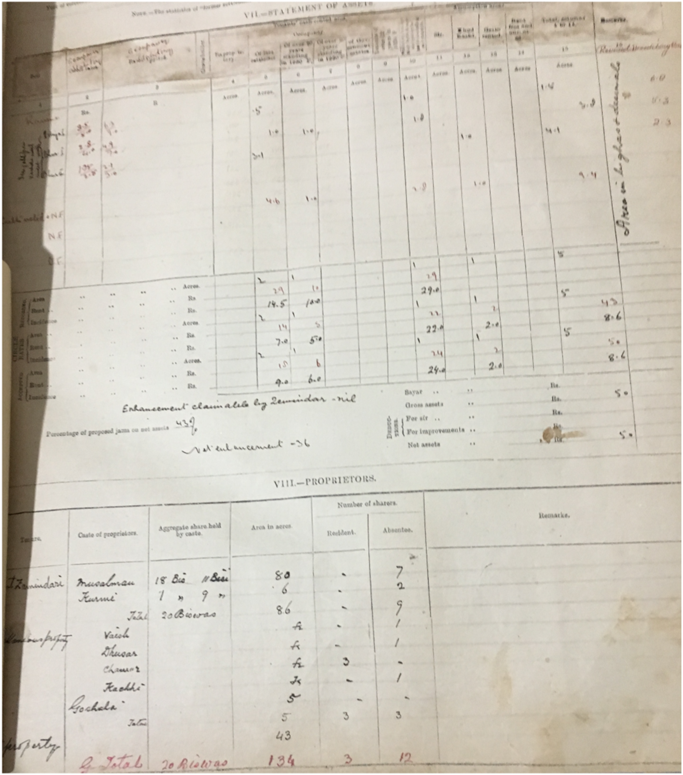
The most important information for our purposes was the breakdown of cultivated acreage in the village by landlord caste and land tenure system, which allows a calculation of the percentage of land owned by fewer than five individuals, and the number of absentee and resident proprietors holding this acreage. I have coded all villages where fewer than five individuals held over 80% of the arable land as having a “small group landlord” or “zamindari” tenure system. Table A.11, Table A.12, and Table A.13 show that using the “legal” definition of single definition of zamindari tenure (a binary measure for whether the land records code the largest landowners as “zamindars”), a threshold of 80% of the arable land having a single owner, or a threshold of 95% of the arable land as having fewer than five owners all produce substantively similar results to the main models. As Figure A.6 shows, there was a wide distribution of the number of landowners in each village, but a dense concentration of villages with between one and four landlords, corresponding to ownership by a single family or set of siblings. 16
The settlement information focuses on land tenure, rather than the population of the village as a whole. However, in 1891, the census authorities printed a detailed set of village census statistics for each district, the Agra volume of which has been preserved in the British Library. This volume includes data on village population, literacy levels, a rough occupational breakdown, resident religion, and resident caste (though only for the largest caste in the village, or other castes with over 25% of the population). From these figures, I calculated a set of binary indicators for whether more than 25% of a village’s population was from the five upper castes. 17 Since landownership is sometimes thought of as another component of upper caste dominance, some supplemental tests use a binary measure of whether upper castes were the largest landowning group, taken from the archival data.
While these caste figures are taken from a century ago, there is reason to think they give a broadly accurate picture of the distribution of castes today. Migration to or between rural villages in Agra is virtually unheard of. In 2001, 99.3% of rural men lived in the village they were born in. Due to its relative prosperity, Agra is also less likely to be a source of emigration than other parts of India. Out of all men born in Agra district who lived in UP in 2011, 98.3% lived in Agra district, and even in urban areas of Agra, 97.5% of men lived in the city they were born in. 18 Census figures also indicate little change in caste composition over time. The average sample village had a Scheduled Caste population of 25.6% in 1961 and 23.3% in 2011.
General Trends in Public Goods Provision
Figure A.4 and Table A.1 show the basic temporal trends in the provision of six public goods. The lines trace the proportion of villages not having the good at each census or gazetteer year—obtaining the good for the first time is a “failure.” Overall, the provision of these public services has improved dramatically over time, where primary schools, electricity, roads, and irrigation have become universal or virtually universal by 2011. Figure 2 shows the distribution of primary and high schools in 1924, 1991, and 2011. The massive expansion of primary school provision between 1924 and 1991 is very notable, as is the expansion of high schools and general rise in public goods provision during the 1991–2011 period, after the 1993 creation of autonomous local government panchayats. Schools in Agra District. Notes: The map shows the distribution of school types by village. There were no rural high schools in 1924. Blank space corresponds to towns or uninhabited villages.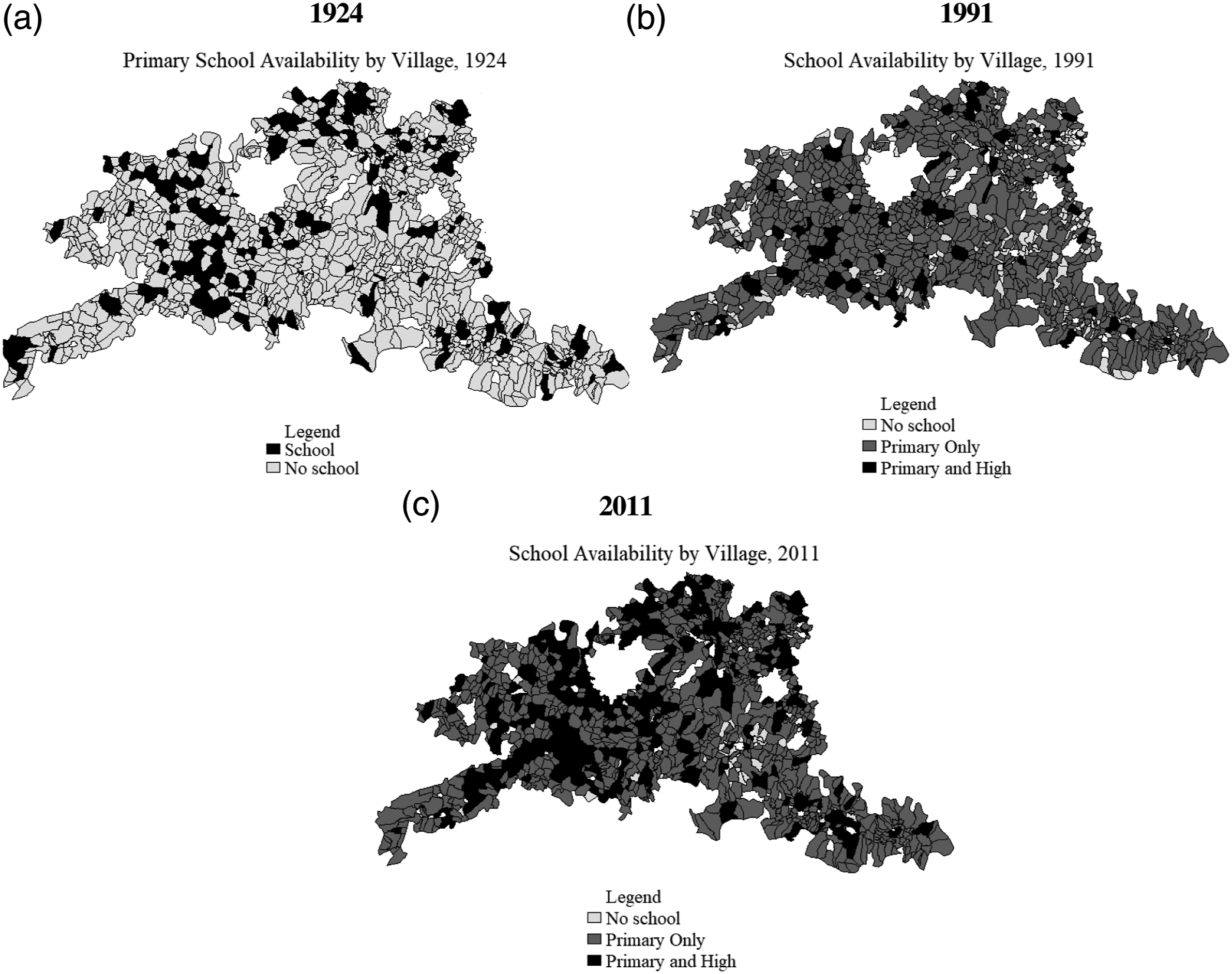
The trends also differ across types of goods. Primary school provision has been increasing continuously toward a norm of at least one per village since the colonial period. Post office provision increased during the colonial period but plateaued in the 21st century. Provision of high schools, middle schools, and electricity was virtually nonexistent in rural areas before 1971 but became very common afterward. 19
Analysis
Estimation
To reflect existing practice, the initial models are cross-sectional, with a series of regression models reporting naive correlations between public goods presence and the land tenure and caste composition variables. These cross-sectional models attempt to account for geographical or technocratic factors that could influence public goods provision. Since villages are positioned in space, there is a strong possibility of spatial-autocorrelation—that error terms are correlated either due to spatially correlated unobservable variables or that the acquisition of a good in one village encourages its acquisition in nearby villages.
20
To account for spatial interdependence, all models include a spatial lag of the dependent variable, weighted by inverse Euclidian distance. Since distance to the city of Agra, the largest city and district headquarters, might have a large effect on public goods provision, all models also include the Euclidian distance to Agra and the subdistrict headquarters town as well as subdistrict fixed effects. In addition to these spatial variables, the basic models control for logged population in 1891 (since a rational government seeking to serve large numbers of people would seek or provide goods to the largest villages first), and dummies for soil type in the area.
21
The estimating equation for the cross-sectional models is

While results are reported for six public goods, our outcome of interest is the overall distribution of public goods, and we have no priors about the effects on specific goods. To reflect this fact, all the main tables estimate treatment effects on an index of the six dependent variables calculated using the procedure described by Anderson (2008). This procedure is designed to adjust for the possibility of spurious “significant” findings when using multiple outcomes by calculating a summary index from the weighted means of a family of standardized outcomes (in this case, village-level public goods). Outcomes are weighted “by the inverse of the covariance matrix of the [normalized] outcomes” (Anderson, 2008, 1485). Informally, this means that outcomes that are highly correlated with each other receive less weight in the construction of the summary index, and that therefore the coefficients estimates for the index may differ from the average of the coefficient estimates for the components. Moreover, as Schwab et al. (2020, 953–4) point out, “When one aggregates variables into an index, random errors that are uncorrelated across indicators are more likely to cancel each other out as the number of indicators increases. Thus, summary indices as outcomes can be less noisy than individual variables.”
To estimate the average predictors of public good provision across villages over time, I use a Cox proportional hazard model, with “failure” being the creation of a new public good. In the survival models, observations are dropped after the initial failure, even if a good is subsequently provided. If the values of the covariates for village v are a vector X
v
= Xv1905, …Xv2011, then
Both land tenure systems and the distribution of caste groups are endogenous to the geography and history of villages, and these selection effects may hold even for villages with similar soils, isolation, population, and irrigation. To reduce unobserved spatial variation, some supplemental models make comparisons between neighboring villages. Villages were matched without replacement to the closest village within a five-kilometer radius with a different treatment status and an 1891 population differential of no more than 100%. Villages without a suitable pair were dropped. The pair models are estimated with all the standard controls and pair fixed effects.
Cross-Sectional Results: Landholding
Are unequal colonial landholding patterns negatively correlated with contemporary public goods provision at the village level? No matter what point in the 20th or early 21st century is selected, the answer appears to be no. Figure 3 and Table A.5 show the results of a series of simple linear regression models of public goods provision in 2011, 1991, and 1924. These years were chosen as being the last years with full data coverage for the three political eras discussed in Section 3: The Colonial, Congress, and Mandal. Colonial Land Tenure and Public Goods. Notes: The graph displays the coefficient estimates for colonial landlord tenure from Table A.5. The controls are a spatial weight calculated based on inverse distance, distance from Agra, distance from the subdistrict capital, dummies for subdistrict and soil type, and logged population in 1891.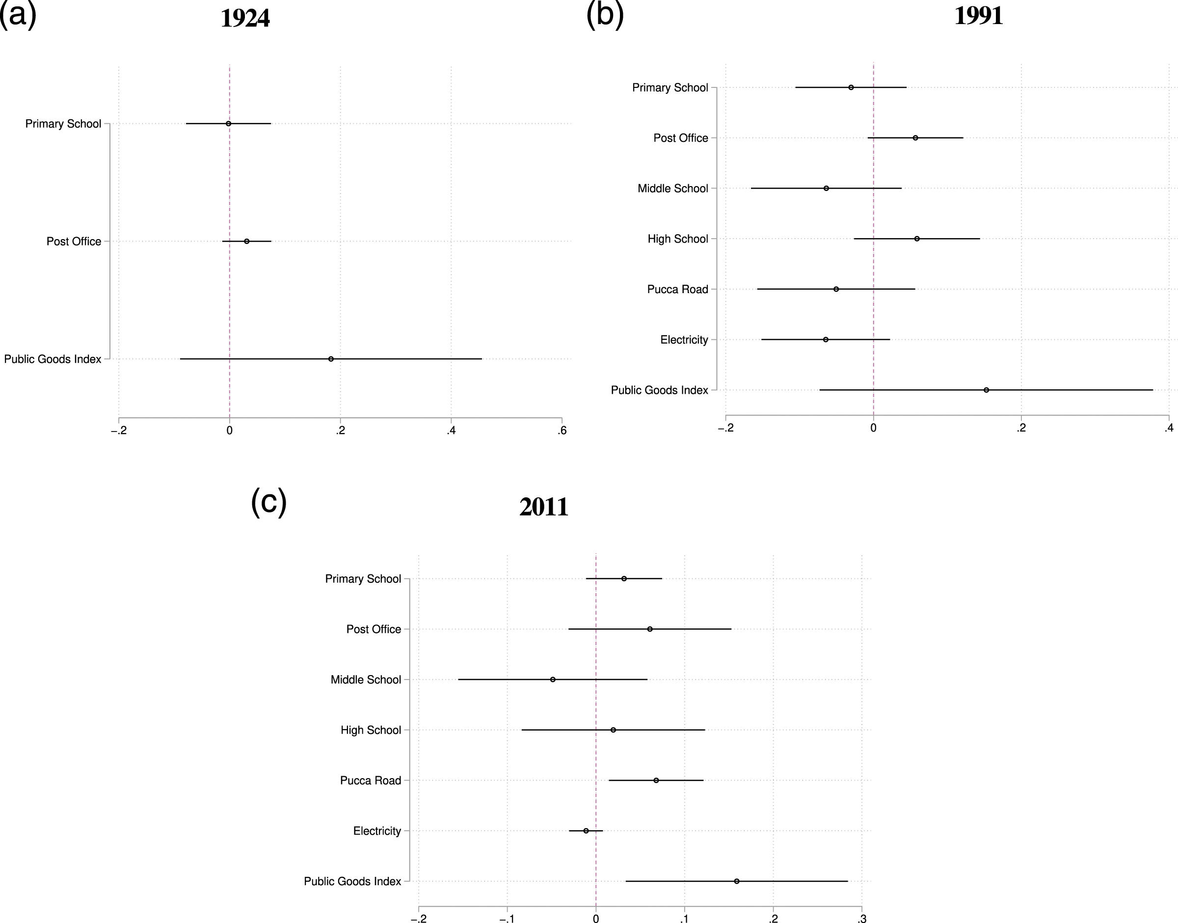
Villages where 80% of the land was owned by fewer than five people in 1929 do not appear to be less likely than other villages to have acquired local public goods in any of these years. The overall effect is positive in all years and statistically significant in 2011—in this year, ownership by a small group was associated with an increase of .17 standard deviations in the public goods index and a 7% higher probability of a paved approach road. 23 The overall effect of land tenure on the hazard rate for acquiring public goods is also close to zero overall in survival models (Table A.10, Panel A).
Is this positive effect a product of unobserved differences between villages, perhaps because small-group owned villages were located in less accessible parts of the district? 24 Table A.6 shows the results for comparisons within matched pairs of neighboring villages. Though the models are somewhat underpowered, there is no evidence for a negative association between colonial land tenure in any time period.
These results pool villages where the landowners were absentees with those where they were residents. Figure 4, based on Table A.8, shows the results of models that interact landlord tenure with the 1929 proportion of absentee landlords. In villages with a high proportion of absentees, the effect of landlord tenure (the sum of the coefficients) is close to zero. However, where most of the colonial landlords were residents, the estimated effect of small group landowning on public goods provision is positive and statistically significant in both 1991 and 2011. While villages with a small group of resident landlords have relatively high levels of public goods provision (between .33 and .55 standard deviations more), villages with absentees are virtually identical to villages with more than four landowners. Colonial Land Tenure, Absenteeism, and Public Goods. Notes: The graph displays the coefficient estimates for colonial landlord tenure on the public goods index from Table A.8, a series of linear regressions with the presence of the good as the dependent variable, and standard errors adjusted for spatial autocorrelation. The controls are a spatial weight calculated based on inverse distance, distance from Agra, distance from the subdistrict capital, dummies for substrict and soil type, and logged population in 1891.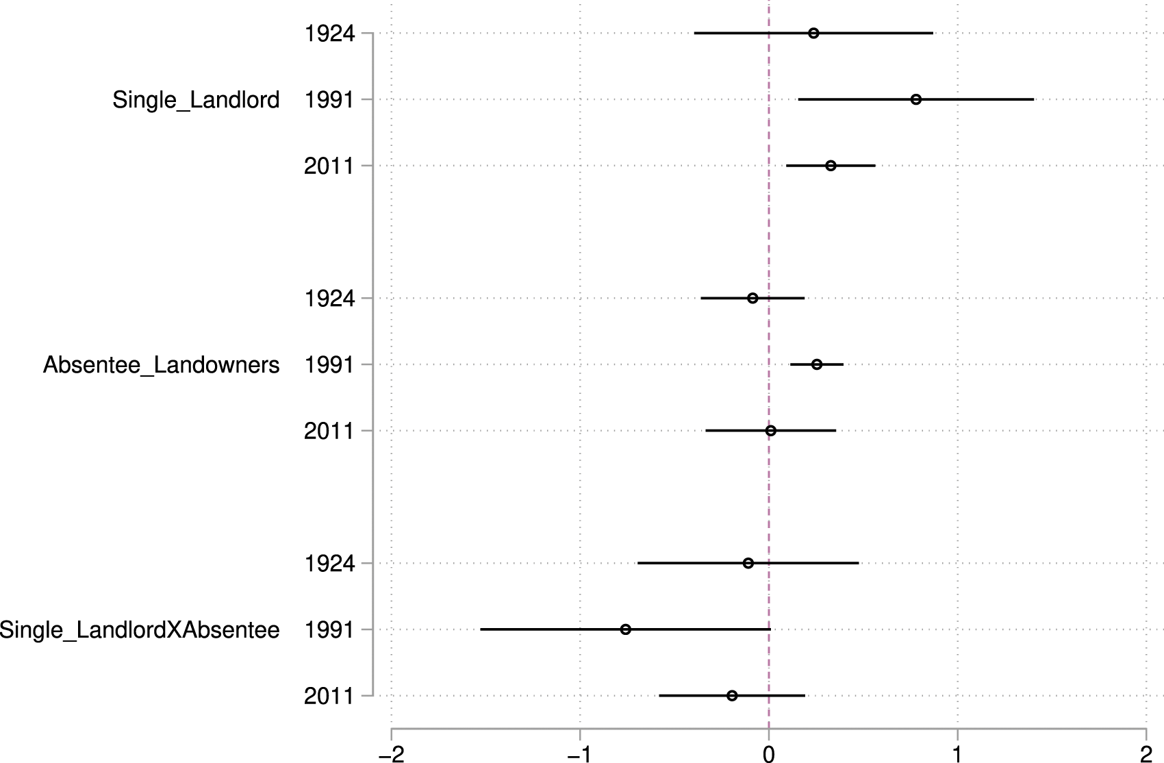
One interesting feature of Figure 4 is that the positive effect of having a small number of landowners is largest for goods that are used by the rich or difficult to provide privately, especially high schools and roads, and more modest for lower levels of education. While landowners may be able to advocate for their villages, they pursue their own priorities while doing so.
The case of the most persistently influential colonial landowning family in Agra district, the Bhadauria Rajas of Bhadawar, provides suggestive evidence that wealthy local landowners are more effective lobbyists for central resources than the poor themselves. The family has been established in Bah Tehsil since at least the 16th century and in the colonial period enjoyed a close relationship with the colonial government. Remarkably, the family has been able to maintain its political power after independence. Successive Rajas have held the Bah state legislative seat for the majority of the post-independence period.
25
The current Raja has served as a state minister several times, has been chairman of the Bah cooperative bank since 1989, and owns a great deal of land. The family’s combination of money, a strong local base and limited ideological commitment, has meant that they switch parties frequently (the current Raja has done so three times) and are almost always associated with the state government. Jayaram (2016, 35–6) notes that in Agra, as in the rest of UP: These regional barons, or Chaudharys…are invariably landowners, including both hereditary landlords as well as middle-peasants empowered by post-independence land reforms…Traditional elites or feudal zamindars from Rajput, Muslim and Jat communities…are valuable to senior party leaders only insofar as they raise sufficiently high levels of revenue for the party coffers….[Lower caste leaders] are valued members of the SP power network in Agra alongside Maharaja Aridaman Singh, a Rajput…The independence and affluence of local leaders enable [them] to exert influence over the state bureaucracy.
The Raja has used his influence to divert resources to Bah Tehsil. The Raja’s successful use of state funds to renovate the access roads, riverbank, and temples in the local pilgrimage center of Bateshwar (of which the Raja is the principal trustee) is one example of this type of advocacy, as are his attempts to build a new canal to reduce the chronic shortage of drinking water in Agra district. 26 Estimating quantitatively the effects of one influential family’s presence is complicated by geographical differences—Bah Tehsil is the most isolated part of the district. However, there is no difference between public good levels in Bah and other parts of Agra district, and the difference between Bah and the rest of the district is positive and statistically significant for some goods once distance from Agra is included in the model (Table A.20). At least in Agra, the most “feudal” part of the district has not been neglected by the state in the provision of rural public goods.
Cross-Sectional Results: Caste
Do villages inhabited by powerful caste groups tend to get more local public goods? The main models focus on a binary measure for whether the plurality caste in 1891 was one of five high-status castes. Overall, the presence of upper castes has no effect on survival rates in hazard models (Table A.10, Panel B). However, the effect varies over time. Figure 5 summarizes the results, which are also reported in Table A.14. The association between upper caste population and public goods is positive and statistically significant in 1991, with upper caste villages have a summary index score .16 standard deviations higher than other villages and a 7 percentage point higher probability of having a paved road. In 2011, however, the effect is essentially zero. The matched pairs models produce similar results (Table A.16). Upper Castes and Public Goods. Notes: The graph displays the coefficient estimates for the proportion of upper castes from Table A.5, a series of linear regressions with the presence of the good as the dependent variable and standard errors adjusted for spatial autocorrelation. The controls are a spatial weight calculated based on inverse distance, distance from Agra, distance from the subdistrict capital, dummies for subdistrict and soil type, and logged population in 1891.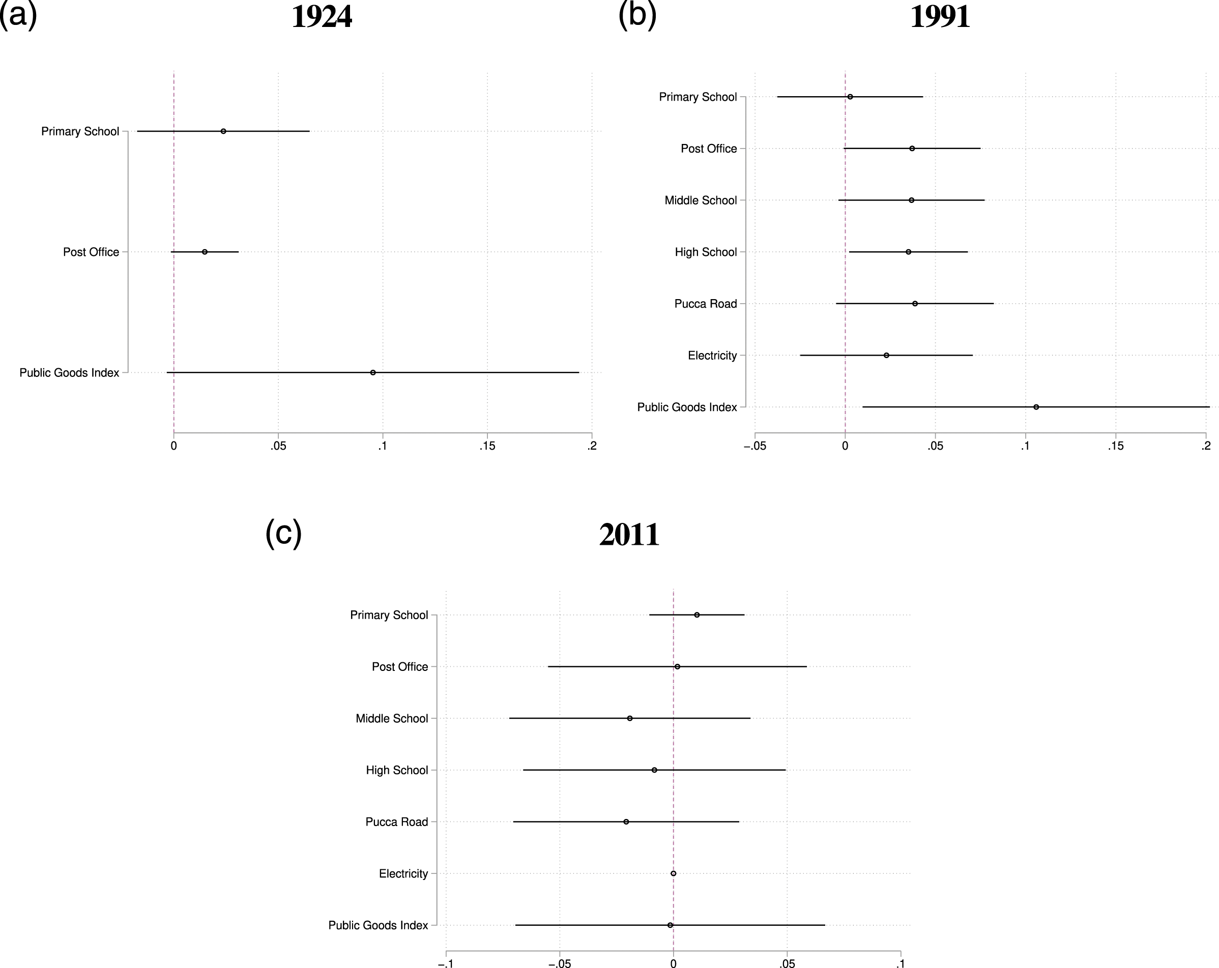
Along with population size, landownership is often thought to be a major component of caste “dominance” of specific caste groups (Anderson et al., 2015). Table A.15 shows that villages where upper castes were the largest landowning group in 1929 were more likely to have public goods than other villages in 1991, but not in 2011.
As with landlordism, the positive effects of upper caste population are strongest for goods that would be of greater use to the already wealthy and educated. In particular, provision of high schools was higher for upper caste villages than other villages in 1991, while primary education was not, echoing the conclusions of Chaudhary (2009) and Suryanarayan (2017). Upper caste groups used the de facto excludability of certain types of local public goods to disproportionately transfer resources to their own groups.
These patterns are reflected in Figure 6, which shows levels of provision for primary schools and post offices. Levels of public goods provision were low for all types of villages in the colonial period, but after independence, provision in upper caste villages surged ahead. This advantage has somewhat, though not entirely, reversed itself since 1971. While a “higher” caste status does seem associated with provision, this effect appears to vary greatly over time. Trends in Provision by Caste Category. Notes: The subfigures show the proportion of villages without a good in each census or gazetteer year. Upper caste villages are those where Brahmins, Rajputs, Banias, or Jats were the largest castes in 1891.
Mechanisms
Why Do the Results Differ From Existing Findings?
The gap between the findings in this paper (that the effect of colonial landlords and the presence of upper castes on public good are conditionally positive) and the common scholarly view that historical inequality has a negative effect on public goods provision stem from the different units of analysis. While villages in the same district, and still more neighboring villages, typically are similar on a wide variety of measures of environment, culture, and institutional experiences, states of India differ from each other greatly on all these dimensions, some of which might be correlated with the incidences of land tenure systems.
Figure 7, based on Table A.18, shows that this is the case, using 1981 district-level public goods data taken from Banerjee and Iyer (2005). Overall, “non-landlord tenure” is strongly correlated with public goods provision in India as a whole. This also holds, but more weakly, once areas with ryotwari tenure are excluded. However, the correlation disappears once state fixed effects are used, or when we focus on comparisons within the state of Uttar Pradesh. While land tenure systems may explain interstate variation, they cannot explain variation within states. This is consistent with Lee’s (2019) claim that the effect of zamindari tenure is mediated through its effect on the structure of the state, particularly in ryotwari and permanently settled areas. Cross District Comparisons. Notes: The data shot the coefficient estimates for “non-landlord tenure,” and twice born jatis (Brahmins, Banias, and Rajputs), taken from Tables A.18 and A.19, a series of linear regressions with the 1981 public goods index as the dependent variable and standard errors adjusted for spatial autocorrelation. The data are taken from Banerjee and Iyer (2005) and Lee (2019a), and princely states are excluded.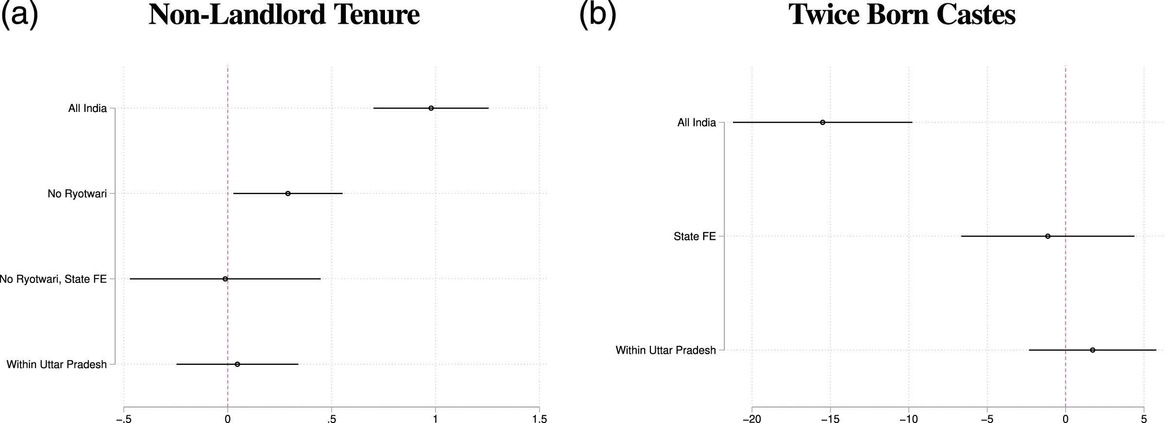
Part B of Figure 7, based on Table A.19, shows the analogous results for the proportion of Brahmins, the highest status group in the traditional caste system, one of the wealthiest caste groups and the caste group most associated with the traditional caste system (Suryanarayan, 2017). 27 The naive regression results show that the presence of these groups is negatively associated with public goods provision. These findings will be unsurprising to most students of India: Brahmins are concentrated in Northern India, which has always had lower levels of public goods provision than the rest of the country. However, the estimates are sharply reduced when state fixed effects are added and are close to zero within Uttar Pradesh. While the presence of high-status groups—or, put another way, the investment of the elite in ideas of religiously legitimated status—is strongly associated with low levels of public goods provision at the regional level, within regions, this relationship does not hold.
Why Do the Effects Vary Over Time?
We have already discussed the historical factors that might lead to upper castes being overrepresented in politics and the bureaucracy in Uttar Pradesh. If these groups are overrepresented among decision-makers, areas with populations of these groups should tend to receive more resources, all else equal.
However, the nature and level of overrepresentation in Uttar Pradesh has changed over the past century in ways that have reduced the power of the upper castes. During the colonial period, British officials favored individuals from the “martial races,” especially Jats. Brahmins and Kayasths were well represented in the years after independence and retained power into the 1980s, after which smaller castes gained power. These detailed patterns of changes in caste power can be seen in the data. Tables A.21, A.22, and A.23 show the conditional relationship between a sizable presence of the major caste groups and public goods provision. Jat villages had higher levels of provision than other villages in 1924, while Brahmin villages had higher levels of provision than other villages in 1991. Both types of village were virtually identical to others in 2011. In all periods, Chamar villages do not have a consistent and statistically significant association with increased public goods provision, though there does seem to be a gradual upward trend in the coefficients over time. These patterns appear broadly consistent with ethnic favoritism by state-level elites. The decline of the estimated effect of Jats between the colonial and Congress periods tracks their political decline, and the increase of the estimated effect of Brahmins in the Congress period tracks their political dominance in these years.
The correspondence between state-level political power and local-level public goods can also be seen in Table A.24, which shows the results of a series of panel regression models with village and year fixed effects. The key independent variable is a binary measure of the proportion of years in the period since the previous gazetteer or census that the UP Chief Minister was from a caste that had over 25% of the village population in 1891. 28
The results show that having a coethnic CM in office is positively associated with having public goods in the village, with the effect being statistically significant for three of the six goods and the summary index. The effect can be seen graphically in Figure A.7 which shows the percentage of villages with primary schools over time to two selected castes, overlaid against the years a member of the groups was Chief Minister. The rise of the Yadavs from a caste with below average public-school provision in their villages to one with above average provision in their villages is gradual but noticeable. The effects on the Lodhas, a small group that became politically prominent within the BJP coalition during the 1990s when a Lodha, was Chief Minister, were more dramatic. During this decade, Lodha villages in Agra went from being less likely to have a school than other villages to being just as likely, before declining in relative terms after Singh left office.
Can we similarly track changes in the power of large landowners? To the extent that the historiographical consensus can be summarized, large zamindars were relatively influential in the colonial period, but in the context of an authoritarian regime, that was unsympathetic to most Indians (Reeves, 1991). Immediately after independence, many ex-zamindars entered politics in UP, but the number has gradually declined over time (Zerinini, 2009, 49–52), as the ex-landlords were replaced by political professionals of humble origins. This seems to roughly parallel both the rise and fall of upper caste influence discussed above and the peak of the positive effect of resident landowners in the 20th century. However, the ability of traditional rural elites to retain political influence, and their willingness to use this influence, is a topic in need of further exploration.
Why Is There Persistence?
One generic challenge in the historical political economy literature is to show how and why historical changes have persisted to cause contemporary effects. For one of the two independent variables discussed in this paper, the presence of upper castes, the persistence mechanism is relatively straightforward, since, given only modest differential levels of migration, mortality, and fertility, the villages in the dataset with relatively high upper caste populations in 1891 are very likely to be the villages with large upper caste populations today.
Similarly, in 1924, large zamindars were still in power and in possession of all their land and legal privileges and thus fully capable of bending the political system in their favor (Reeves, 1991). However, in the post-independence period, zamindari tenure was formally abolished, and some of their land redistributed. An alternative explanation for the positive association between landlords and public goods at the village level is that the Indian state, when it abolished zamindari tenure, did such a thorough job as to leave no trace of the existing elite, or perhaps made the distribution of land more equal than in areas less affected by the land reform. This alternative hypothesis should be differentiated from the claim made in this paper, that villages with colonial landlords have remained more unequal than others, but that this inequality has been advantageous under certain conditions.
There are three reasons to discount this alternative hypothesis. Firstly, it is widely believed that zamindari abolition fell well short of having a leveling effect in the countryside. Metcalf (1967, 5), summarizing the historiographical consensus, claimed that “the initial proposals…were even in their initial conception excessively timid…The lot of the landless and the outcaste…was in no way improved by the abolition legislation, while the cultivating castes who were its beneficiaries simply became tenants of the state rather than of the zamindar.” Secondly, even in 1924, before zamindari abolition, the presence of large landlords was uncorrelated with public goods provision (Table A.5). Thirdly, as we have seen, landlord tenure is not negatively correlated with public goods in villages with resident landowners, who were less affected by land reform.
Those landlords who did survive had strong incentives to win local political points by bringing public goods to their district. The Rajas of Bhadawar are far from unique in their enthusiastic move into electoral politics in their home districts, with the landlord politician being so common that “be tedious here to describe at length individual cases” (Metcalf, 1967, 15). While some of the appeal of such politicians is based on their inherited charisma, they must also participate in clientelist politics 29 and in the provision of local public goods (Skoda & Bag, 2018). However, since not every landlord was suited for the rough and tumble of the political world, landlord politicians faced fierce competition as public goods providers, leading to a slow decline in their influence. 30 This is consistent with the finding that the effects of large landlord presence were always modest and have become further attenuated over time.
Discussion and Conclusion
The results show that in predicting the effect of historical inequality, the level of aggregation can have a strong influence on the results. Results that have strong empirical support at the national or district level, such as the influence of colonial land tenure and the presence of upper castes, have no support at the village level once population and district location are accounted for. While these variables may be correlated with regional differences, within a not untypical North Indian district, these variables do not have a negative effect. In fact, strong resident landlords may have positive effects, possibly by serving as privileged intermediaries between the state and their communities.
The effect of inequality can also shift over time. While a large population of traditional upper castes has a positive association with public service provision in the colonial era and during the period of Congress hegemony after independence, the exact nature of the favored group has shifted. However, the upper caste advantage has disappeared since 1991. This appears attributable to shift in the balance of ethnic power at the state level, with shifts in power toward specific lower caste groups benefiting even the poor village dwellers of Agra district. While Brahmins were effective at transferring state resources to their communities in the era of Congress Party dominance, their presence does not influence public service provision in the more democratic political order that has emerged since 1990.
More broadly, the results suggest that at the local level, historical institutions are not destiny and cannot put communities on immutable “good” or “bad” trajectories. Rather, traits can operate differently in different contexts. Traits that are advantageous for communities in one period may matter little in a subsequent one, and traits that negatively influence a region as a whole may have positive effects when the pie is divided within the region. Within unequal societies, the communities of the advantaged may have advantages in getting resources from the state.
Supplemental Material
Supplemental Material - Historical Inequality at the Grassroots: Local Public Goods in an Indian District, 1905–2011
Supplemental Material for Historical Inequality at the Grassroots: Local Public Goods in an Indian District, 1905–2011 by Alexander Lee in Comparative Political Studies
Footnotes
Declaration of Conflicting Interests
The author(s) declared no potential conflicts of interest with respect to the research, authorship, and/or publication of this article.
Funding
The author(s) received no financial support for the research, authorship, and/or publication of this article.
Supplemental Material
Supplemental material for this article is available online.
Notes
Author Biography
References
Supplementary Material
Please find the following supplemental material available below.
For Open Access articles published under a Creative Commons License, all supplemental material carries the same license as the article it is associated with.
For non-Open Access articles published, all supplemental material carries a non-exclusive license, and permission requests for re-use of supplemental material or any part of supplemental material shall be sent directly to the copyright owner as specified in the copyright notice associated with the article.