




Abstract
The observatory of Ulugh Beg, erected in Samarqand in the 1420s, represents the culmination in the development of astronomical observatories in the Islamic world. After its rediscovery and excavation in the early twentieth century there have been several attempts to reconstruct its appearance and explain how it worked in detail, based on archaeological finds and the analysis of relevant manuscripts. A new look at illustrated copies of an important manuscript provides new, hitherto unmentioned details to the understanding of this instrument. Based on previous reports, we have created a virtual reconstruction of the observatory and the new version of the instrument, from which we have gained new insights.
Keywords
Introduction
The last famous school of astronomical activity in the world of Medieval Islam was established in the early fifteenth century by Timur Leng’s grandson, the ruler and supporter of sciences, Ulugh Beg (1394–1449) in Samarqand. 1 A large observatory building was erected in the early 1420s. The astronomical tables, titled the Sulṭānī zīj, and the star catalogue embedded in it (with the epoch of the beginning of the year 841 of the Hijra = 4 July 1437 A.D.) were highly revered sources also in European astronomy until the seventeenth century. However, after the assassination of Ulugh Beg, his scientific circle was dispersed, and the splendiferous observatory was abandoned, and finally destroyed and plundered for bricks until deep into the twentieth century. 2
Several excavation campaigns by Russian, later Soviet archaeologists in 1908–1914, 1941, and 1948 revealed the remains of a large cylindrical building which surrounded a huge meridian trench, cut down to about 10 m into the bedrock, in which two curved walls flanked by three staircases were found. The walls were topped with smooth marble plates to form a cylindrical arc with curvature radius of about 40.1 m. The western wall had plaques with abjad numbers (Arabic alphanumerical notation) indicating degrees of altitude, and two parallel grooves were cut into the marble plates.
Following excavations, archaeological results, and research of manuscripts soon revealed an archetype for the central meridian instrument: Khujandī’s (Abū Maḥmūd Ḥāmid b. al-Khiḍr al-Khujandī (c. 945–1000 A.D.)) Fakhrī sextant, which had been constructed in 994 A.D. and thus predates the Samarqand observatory by more than four centuries. Several authors have tried to reconstruct the shape and use of the instrument and its building, 3 and discussed the instrument either as Quadrant or Sextant, usually shown as embedded in a 30-m high cylindrical building.
However, some details in regard to the operation and differences between the archetype and the later instrument, the greatest of its kind ever constructed, had so far not been evaluated, leaving room for speculation and misinterpretation among modern scholars. These issues seem to have not been resolved or explained adequately, or have lain dormant in the last decades. We aim to shed new light on these aspects on the basis of an available, but not hitherto deservedly considered, piece of evidence which will be presented in this study.
The paper is organized according to the following topics: in Section “Khujandī’s Fakhrī Sextant,” we discuss the original Fakhrī sextant, a large instrument to study the solar meridian transit, in its construction and operation. In Section “Kāshī’s Fakhrī Sextant,” we discuss the model described by Ghiyāth al-Dīn Jamshīd al-Kāshī (c. 1380–1429 A.D.) shortly before he became an outstanding member of the Samarqand observatory. It bears the same name as Khujandī’s sextant, but its dimensions and shape substantially resemble the remnants of the central instrument of the Samarqand observatory. In section “The principal instrument of the Samarqand observatory,” we present our virtual reconstruction of the central instrument of the Samarqand observatory based on our new findings in Kashī’s treatise and discuss differences to earlier interpretations and reconstructions. Section “Conclusion” closes with a short summary.
Khujandī’s Fakhrī Sextant
About the first half of 994 A.D., Khujandī built a gigantic sextant (suds) exclusively for the measurement of the obliquity of the ecliptic near Rayy (near modern Tehran) named the Fakhrī Sextant, after his patron Fakhr al-Dawla Abu ’l-Ḥasan ‘Alī b. al-Ḥasan (d. 997 A.D.), an emir of the Buyid dynasty of Iran. 4 The sources of information about this instrument are as follows:
In (
The meridian line is marked on the ground. Two walls of 20 cubits (~ 10 m) height are erected equidistant from it, with a distance of 7 cubits (~ 3.5 m) between them. At the top, an arch is built between them from the south with a round aperture of radius 1 span (= 1/3 cubit ~ 17 cm) (according to (
On its application, we are told, when the Sun reaches the meridian circle, its rays shine through the aperture onto the meridian line, so that the size of the sunbeam is spread in the shape of a cone which is greater than that of the aperture. An auxiliary device is made in the shape of a circle (in (
As indicated in Khujandī’s account, a sextant of radius 40 cubits (~ 20 m) can, at most, be graduated to each 10″; every degree corresponds to an arc of about 34.9 cm in length, each arc-minute to about 6 mm, and so the smallest subdivision readable from it with a length of ~ 1 mm would correspond to 10″. Bīrūnī says that the instrument had been erected on Mt. Ṭabarak, near Rayy, which is located in a northern geographical latitude of ~ 35;35.5° and a longitude of ~ 51;28° east of Greenwich (Mean Local Time MLT = UT + 3;26 hours), and about 1100 m above the sea level.
10
By this instrument, Khujandī measured the maximum and minimum annual solar noon altitudes, as presented in Table 1. He could measure the solar noon altitude on the 2 days around the summer solstice (occurred in reality on 16 June 994, 23:36 TT (23:09 UT), or 17 June 994, at ~ 2:35 MLT), but cloudy weather prevented him to observe the Sun on the winter solstice day (occurred on 16 December 994, at 7:01 UT (7:28 TT with ΔT = 1602s), or ~10:27 MLT)
11
), and allowed observation only on the two days around its occurrence. At the latitude of this site, both solstice meridian altitudes are above 30°; therefore, a sextant (providing a maximum angular distance of 60° from the zenith, or minimum altitude of 30° from the mathematical horizon) is enough for these observations (Figure 1). The error in his solar noon altitudes at the summer solstice amounts to about −1′, but, in contrast, his values for the noon altitude of the Sun about the winter solstice are ~ + 1′ and ~ + 1.5′ off.
12
From these data, Khujandī found the obliquity of the ecliptic to be ε = 23;32,21° (modern computation: ~
al-Khujandī’s solar observations at the solstices in 994 A.D.

The Fakhrī Sextant (Illustration after Repsold 1918).
In practice, this huge instrument did no longer properly work after a while; as Khujandī informed Bīrūnī orally about a discrepancy in the sextant, the aperture had subsided downwards by 1 span (~ 17 cm). We must assume this was an undesirable, but quite expectable, consequence on account of the two tall walls being erected just on either side of a deep excavation. Bīrūnī implicitly assumes that the settling of the aperture occurred after the solar observations at the summer solstice and before the measurements of the solar meridian altitude around the winter solstice in 994 A.D., which led to Khujandī measuring a greater value for the noon altitudes of the Sun at the latter time; by this, Bīrūnī wishes to explain the reason that Khujandī reached a smaller value for the obliquity of the ecliptic than those measured by other Middle Eastern astronomers around that time. But, this is faulty, simply because a one-span (=1/3 cubit) downwards shift of the aperture in a sextant of radius 40 cubits will have a more undesirable consequence by causing larger errors in the altitudes than can be found in Khujandī’s measurements. Consider Figure 2(a): The settling of the aperture by a distance d in a sextant of radius R causes a positive deviation ζ = sin−1(d cos h/R) in a meridian altitude h. The values of ζ (in arc-minutes) for the full quadrant are plotted against h (in degrees) in Figure 2(b). So, it is clear that a vertical displacement of d = 1/3 cubit in the centre of the aperture of a quadrant of radius R = 40 cubits causes errors of up to 29′ in altitude. For h = 31° (winter solstice), ζ ≈ 25′ which is appreciably larger than the trivial errors ~ + 1.5′ we have found in Khujandī’s solar noon altitudes around the winter solstice, which can in fact be simply explained by the effect of atmospheric refraction (cf. Table 1).

(a) A slight settling of the opening in the wall causes an error ζ in the observed altitude. (b) Altitude error for a settling of 1/3 cubits when R = 40 cubits.
It should have been known so far that despite the enormous expenditure of effort on the construction of such a gigantic meridian sextant, it suffers from two obvious intrinsic limitations: (1) Its proper and correct application is on the whole dependent on the proper position of the centre of the aperture at exactly the centre of the circle of which the upper surface of the sextant is an arc. (2) It could be utilized only for the solar observations,
13
whereas there is evidence of the comprehensive measurements that could be done by such large-sized meridian instruments from the late Islamic period (after the turn of the eleventh century); the most remarkable example is the mural quadrant of the Maragha observatory, with the aid of which Muḥyī al-Dīn al-Maghribī (d. 1283 A.D.) carried out his systematic observations in the period from 1262 A.D. to 1274 A.D. It was made of copper, with a radius of ~ 324 cm (less than a sixth of Khujandī’s sextant) and was graduated to each arc-minute (corresponding to a length of ~ 1 mm). As shown elsewhere, he used it to measure the meridian altitude of the Sun (preserved in eight observational records), of the superior planets (nine observation reports), and of eight reference stars with the mean absolute errors, respectively, of ~ 3.1′, 4.6′, and 6.2′. He determined ε = 23;30,0° in 1264 A.D. (modern computation: ~
Kāshī’s Fakhrī Sextant
About four centuries after Khujandī, another model of the Fakhrī Sextant was described in Kāshī’s On observational instruments before he joined Ulugh Beg at the Samarqand observatory. The original Persian text, as appeared in a codex surviving at Leiden, Universiteitsbibliotheek (Or. 945), has been published by the late Prof. E.S. Kennedy (1961) with an English translation and a commentary. The account below is from Kennedy’s translation with some slight changes:
15
The Fakhrī Sextant is a sextant of a circle, set up in the plane of the meridian circle, it being graduated in seconds, and it is such that a wall is to be erected, of stone and plaster, such that the length of its base is 80 cubits, its width 4 cubits, and its height in the direction of north 40 cubits and to the south one cubit. Make it such that from the south side, from the base of the wall, to the northern side, from the top of the wall, it is a sextant of the concavity of a ring, so that if a perpendicular from its center is erected to the horizon plane it will pass through one side of the sextant, and that concavity is to be faced with worked stone, and in the middle of that, lengthwise, let a hollow be cut out, the width of which will be 4 digits, and its depth one digit. Inside
16
of that, plates of copper or brass are emplaced so that its visible surface is as accurately circular [as possible]. Graduate it [i.e., the sextant] in degrees, minutes, and seconds. This [instrument] can be constructed when the meridian line has already been determined with the extreme of accuracy.
Kāshī’s cylindrical stone sextant is ~ 40 m in length and radius (i.e. twice as large as Khujandī’s model) and ~ 2 m in width; its northern and southern heights are, respectively, ~ 20 m and ~ 1/2 m. The upper concave surface of the instrument is covered by worked stones, in the middle of which there is a channel ~ 8 cm in width and ~ 2 cm in depth covered by metal plates.
It is obvious that except for the name and general shape, there is no similarity between Khujandī’s and Kāshī’s models of the sextant. The substantial difference between the two is that Kāshī’s sextant, which is twice the size of Khujandī’s, and in effect almost identical in size to that built in Samarqand, is installed completely above the ground with a minimum southern height of 0.5 m, in contrast to Khujandī’s model which was (at least in the southern part) surrounded by the tall walls and was buried beneath the ground. However, the description does not mention the opening in the centre of the arc which would act as projection source for a spot of sunlight to be observed below.
The main questions arising from this short description are as follows:
How did this sextant work in reality when it is exposed to the sky with no means of measuring the meridian altitude of heavenly objects?
For what reason a channel should be dug in the middle of its concave surface, and this surface be worked “as accurately circular as possible”?
The Leiden manuscript of Kāshī’s treatise, of which Kennedy made use, is unillustrated, which is also the case with one of four other manuscripts 17 we have consulted for the present study (denoted by siglum T in Note 17). Fortunately, the other three are illustrated, having a figure for each instrument explained in this work. The figure of Kāshī’s model of the Fakhrī sextant from MSS. M and S are reproduced in Figure 3. It provides us with an interesting piece of evidence in order to answer the two above questions.

Reproductions of the “parallel implement” from the manuscripts M (a) and S (b) (see Note 17). An alidade with pinnulae is attached to a “cursor” moving on the meridian arc instrument. Translations for the labels: (1) Perpendicular pillar, (2) Pinnula, (3) Parallel implement, and (4) Wheel.
Both figures conspicuously show a sighting device, consisting of a long alidade with two pinnulae with tiny holes in their centres (the so-called “perpendicular pillar”), which is perpendicularly mounted on a wheeled “parallel implement” that can move up- and downwards on the upper surface of the sextant. This is, indeed, an ingenious sighting device, which was unprecedented in the medieval Islamic astronomical corpus until Kāshī’s time; only its simple pictorial form is sufficient for answering our main question, concerning the use of Kāshī’s version of the sextant.
Kāshī was, in all likelihood, au fait with Khujandī’s instrument and how it functions, not least because he adopts the same name of Khujandī’s sextant for his own model. Also, he quite probably knew about the serious problem Khujandī encountered through Bīrūnī’s works, which were prevalently read and referred to in the late Islamic period; the problem that the application of Khujandī’s sextant is totally dependent upon the correct position of the aperture in the centre of the basic circle of the sextant is in reality the Achilles’ heel of the instrument; Kāshī’s sighting device not only satisfactorily resolves this problem if the curvature of the instrument’s upper surface is shaped accurately but also enables a practitioner to measure the meridian altitudes of all celestial bodies (not only that of the Sun), by not just observing a projected spot of light but looking towards the sky.
The principal instrument of the Samarqand observatory
The site of Ulugh Beg’s giant observatory has been identified by V.L. Vyatkin. An early visitor to the site (who was however denied access to the freshly identified site in his 1907 visit in the course of an expedition to the Total Solar eclipse of 14 January 1907), the experienced observer Kasimir Graff from Hamburg-Bergedorf observatory reports about the excavation from 1908 from Russian sources of 1909 and 1910: 18 Inside a circular wall, a trench of about 2.5-m width had been dug into the bedrock where two parallel brick walls with marble capstones were arranged. On their top faces which formed a circular arc of about 40.1-m radius, parallel grooves most probably allowed moving a sliding carriage with a dioptre (sighting device) that could be locked in place in perpendicularly incised grooves about every 70 cm, that is, every full degree of altitude in this large circle. One fitting brass pin was found in the excavation. Circular plaques on the western wall showed abjad numbers for every full degree. The number closest to the surface which was still in situ indicated 56°, and the deepest unearthed at that time (indicating higher altitudes), 73°. The exact shape of the dioptre remained, however, unclear. Graff proposed the tip of a minaret as upper sight, but also speculated about angled dioptres to observe stars in the Northern meridian in an assumption that the positions for the catalogue of over 1000 stars which was developed from observations in Samarqand and later also published first by Hyde in the seventeenth century 19 as well as by Knobel in the early twentieth century 20 had been observed with this central instrument. 21
To protect the site from the elements (and ongoing stone looting), the trench was covered by a vault in 1915. 22
After two further major excavation campaigns in 1941 and 1948, Kary-Nyiazov presented a more complete record. 23 The outer circular wall of 23-m radius must have been the foundations of the outer wall of the observatory tower, and not remains of a huge azimuth circle as Vyatkin had originally assumed. However, remains of an azimuth circle consisting of circular marble plates that showed partitions and numerical engravings have been found in the debris in the trench, supporting an idea that such an instrument had been erected on the flat rooftop which then collapsed into the trench. 24 A huge number of mosaic tiles and marble fragments found in the debris indicate the rich decoration this building must have shown in its heyday. The meridian arc would have cut the ground plane at its 45° mark. The abjad plaques for the altitude degrees, of which apparently two more had vanished since Graff’s report, went down to the 80° mark when excavated; below that only simple marks were visible for the full degrees. In the debris that had filled the trench, three more abjad plaques for 21°, 20°, and 19° altitude had been found, from which Vyatkin had concluded that the meridian instrument must have been a complete quadrant that allowed measuring altitudes down to the horizon. During excavation in 1948, a wooden stick was found, secured by bricks, which could have served as original meridian marker. 25 Several attempts to measure the deviation of the central instrument from the true meridian in the twentieth century gave results between 29.4′ west and 3′ east. 26
Kāshī’s model described above is similar in size to the remnants of the gigantic stone cylinder of radius ~ 40 m in the Samarqand observatory. However, in analogy to Khujandī’s description, a part of the latter is buried beneath the ground. In fact, in a letter to his father, 27 he describes the building as of circular form with a perimeter of 200 cubits of Kāshān, and the sextant carved into the rock to avoid a building of excessive height built from bricks of poor quality. Further “the roof of the building will become flat so that other astronomical instruments may be placed on it.”
Until now, it seems to have been taken for granted among many, if not most, historians of medieval astronomy 28 that the instrument was in practice used in the same way as Khujandī’s model, i.e., that a spot of sunlight cast by a small opening in the centre of the meridian arc was observed as it crossed the meridian. However, this would have limited the instrument to pure solar applications. Also, the size of a spot of sunlight even cast by a pinhole, at a distance of 40 m would be approximately 35 cm in diameter, making determining of its accurate position quite difficult. In the 1980s, E. Piini 29 imagined that the instrument must have been utilized by means of an auxiliary device as shown in Figure 4, but such an intuitive reconstruction was apparently ignored since then due to not having any historical background.

A solution proposed by Piini shows a central movable instrument held in place by two assistants. A fine motion allowed shifting the central part of the instrument (Illustration: Piini 1986, reproduced with permission from Sky & Telescope).
In Figure 5, we show a little cart (henceforth referred to as “cursor”) based on Kashī’s drawings with the vertical pillar and pinnulae. To read the altitude, the meridian arc carried a full-length graduation into arc minutes. 30 For a finer graduation, probably divisions as fine as 5 arc-seconds (about 1 mm), a movable ruler for only 1° could have been locally attached to the marble plates where required. The cursor would have carried some pointer or indicating nail which allowed reading the exact altitude. However, no further details on the cursor can be gained from the extant sources.
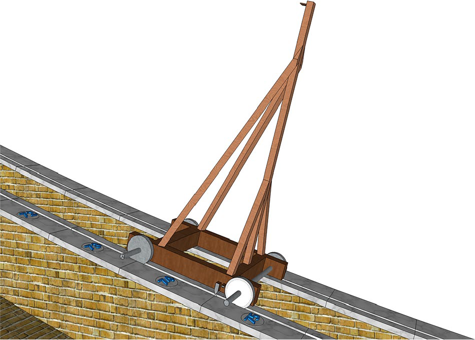
The “parallel implement,” an alidade with pinnulae (sights) mounted on a little cart, or cursor, running along the tracks at Samarqand observatory. The model shown here has added supports which avoid flexion. Abjad numerals on the marble capstones of the western wall have been replaced by modern numbers.
The incisions perpendicular to the rails which apparently could have been used to secure the cursor in every full degree as already interpreted by Graff 31 requires some addition to the simple cart drawn in the extant manuscripts. If the cursor was indeed locked in every full degree, which the accuracy of the distance between the incisions along the existing arc indicates, 32 some wedge-shaped sliding mechanism riding on a graduated 1° arc of the same radius as the meridian arc could have been used to fine-tune the instrument in the arc-minutes and 5 second intervals. Descriptions of such mechanism are missing, however, and this is therefore not shown in our reconstruction. Note that Kāshī’s manuscript predates the construction, so later modifications during the building phase seem plausible. The important point is, however, the dioptre mechanism which can act for projecting a point of sunlight from the upper pinnula to the lower pinnula, or, with the observer placed in the inner staircase, looking up through the pinnulae. Assistants on both side stairs would move the cursor and secure it in the locking holes, and would then be able to read the minutes and smaller divisions from the instrument. Note that this arrangement in its ideal form does not even require any upper sight or pinhole in the centre of the arc’s curvature, as long as the shape of the circle is perfect and the pillar remains perfectly perpendicular to it, or radial to the centre.
Neither sextant nor quadrant
Only very little is known about the observatory’s architecture and size from the contemporary sources. In his Maṭla‘-i Sa‘dayn wa Majma‘-i Baḥrayn, Kamāl al-Dīn ‘Abd al-Razzāq Samarqandī (816/1414–887/1483) describes its sumptuous interior decoration with depictions of astronomical diagrams and globes. 33 In the Bābur-Nāma, the memoirs of the founder of the Mughal Empire, Ẓahīr-ud-Dīn Muḥammad Bābur (1483–1530), in a passage describing events in the late fifteenth century, it is only mentioned as fine, three-storey high building, 34 indicating the building still existed and was not immediately destroyed by Ulugh Beg’s enemies after his assassination. But destruction seems to have started right after Bābur’s account, in 1499. 35
The instrument has been discussed in the literature either as “sextant” 36 (presumably just following the Fakhrī tradition) or as “quadrant,” 37 implying that the missing part above the ground has been continued up to the top of the tower, so that altitudes all the way down to the southern horizon could have been measured. This zero-degree level, which would have been at the same height above ground as the centre point of the curved wall, also would require a roof height of the cylindrical building of about 30 m, on top of which other instruments would have been placed. Kary-Niyazov (1950) proposed a construction of a full quadrant, of which only the range 20°–80°, i.e., an inclined sextant, were used. 38
There is clear archaeological evidence, and an astronomical requirement, that the instrument as built at its location was more than a sextant. The latitude of Samarqand observatory is 39;40,30°; therefore, the winter solstice occurs in an altitude of about 27°, exceeding the range of altitudes (90° . . . 30°) accessible to the original Fakhrī sextant. The top of the curved wall was marked with abjad numerals for the full degrees of altitude. The numbers for 80° . . . 58° are still in place today. The degrees 81 and higher were marked, but without an abjad plaque; 39 therefore, it appears that these high altitudes, where the cursor was at the bottom of the instrument, were of no interest to the observers. Excavators found several more plaques in the debris that filled the instrument trench, most notably those for 21°, 20°, and 19°, which clearly indicate that the instrument could not have ended at 20°, ruling out its nature as “inclined sextant from 80 to 20 degrees.”
We should therefore try to identify the main purpose of this instrument. As noted above, the ecliptic obliquity and its possible variability was a major research question, and likewise observations of the bright planets and the Moon were most likely performed with this instrument to achieve a new set of the solar, lunar and planetary parameters as underlying Ulugh Beg’s Sulṭānī zīj, 40 while for stellar altitudes an instrument which also allows observation in the northern part of the meridian would have been required. Samarqand’s equator altitude is 50;19,30°; therefore, only about ± 30° around this altitude, we should find the altitude zone of most interest if the Moon and the other planets were to be observed in addition to the solstices, which is supported by the documented range of 19° . . . 80° of abjad plaques.
When we consider the operation of the cursor with its vertical pillar, it seems very difficult if not impossible to operate such cursor in altitudes much below 20° – it would require climbing almost vertical stairs or even ropes and ladders while holding on to and lifting the cursor, for which we estimate a mass of no less than 25–40 kg. We therefore conclude that this instrument was in fact built as quintant, with a range of altitudes 18° . . . 90° spanning 72°, governed by the requirement to observe only the planets (including Sun and Moon) in the ecliptic range (Figure 6).

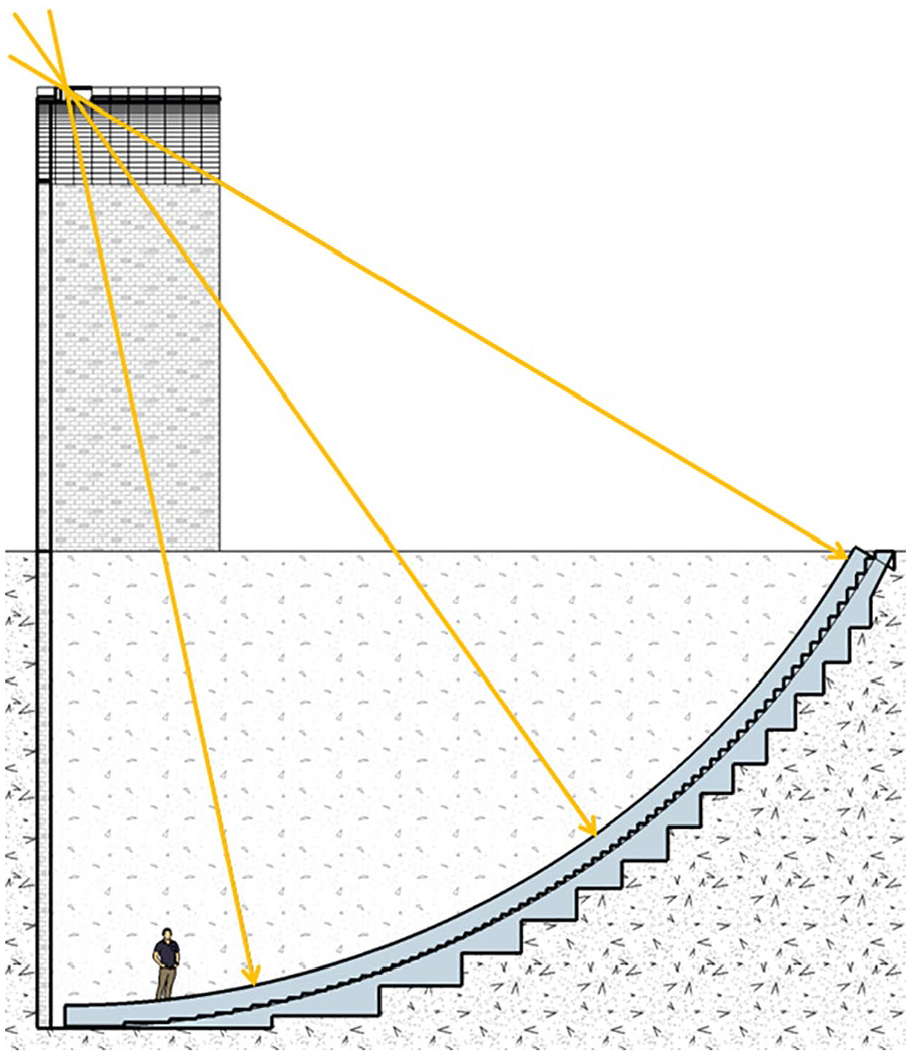
The range of altitudes usable for measurements in the central meridian of Samarqand, shown in a virtual reconstruction of the building following Kary-Niyazov (1950). The hypothesized instrument on the rooftop is not shown. The dotted area of altitudes 80°–90° (bottom of the instrument) was not labelled and seems to have been of no interest. The central area (dashed) shows the range of Solar altitudes (about 47°), but only the wider area of the range of Lunar altitudes (about 19°–80°) requires the range of abjad numeral plaques that have been found in situ or in the excavated debris. The upper part of the arc (right top, shown in white) could hardly have been operated with the cursor-like instrument and most likely never existed. In consequence, the height of the flat roof with auxiliary instruments may have been around 20 m above ground, not the 30 m required to house the full quadrant.
This however means that the actual instrument’s top height along the meridian arc was not higher above ground (17.5 m) than the middle floor of the hypothetical 30-m tower required to contain a full quadrant shown in early reconstructions, and the shape of the roof which is shown in twentieth century reconstructions either flat and topped with a double alidade instrument 41 or inclined 42 cannot be estimated from these considerations alone (Figure 6). However, Kāshī has mentioned both his aim to limit the height, and the flat roof that should allow placement of other instruments. 43 The latter very well matches finds of fragments of an azimuth circle made from marble, which have been excavated from the meridian trench into which they must have collapsed from above, 44 strongly supporting their previous use in such rooftop instruments. This would bring the roof height of the three-storeyed building to a more modest ~20 m.
The other decisive difference between the Fakhrī sextant and the instrument in Samarqand should be expressed again. The view along the pinnulae of the vertical pillar is not governed by the shape or size and in fact not even depends on the existence of any small, almost pinhole-like opening in the south top corner (centre of circle) of the meridian arc. Instead, by the shape of the instrument and placement of the cursor in the carefully carved rails, the perpendicular pillar necessarily must have pointed through this corner. Any constructive element required in the centre axis of the cylindrical wall while the instrument was built and shaped could have been removed before the instrument went into service, but may have been retained for calibration purposes. A wall on the south edge of the building, just a bit wider than the meridian instrument, would have been all that was required for this construction, and may have been built as decorated blind portal similar in style to the elegant buildings like Ulugh Beg’s madrasa at the central square of Samarqand.
The top opening, i.e., the centre of the meridian arc, where the light of the observed objects has to pass, could have been wide, or even the whole south wall of the meridian may indeed have been an open portal to allow seeing the stars in the sky around the object in question. In a building with lower roof, the roof must have had an opening along the meridian to allow observation. Also, visiting and studying the virtual reconstruction from inside allowed some considerations of the meridian room. If we continue the subterranean trench of slightly more than 2-m width and reconstruct the quintant room with closed vertical walls, the instrument must have felt extremely uncomfortable and needlessly claustrophobic. It seems rather plausible that the upper sections of the instrument were open and accessible from every floor. Such a central atrium-like open room would also have provided daylight for the rooms inside the large building. These details seem, however, irrecoverably lost in the mists of history.
Conclusion
In this paper, we have presented a hitherto unconsidered source of information about the observing device in the giant meridian instrument of the Samarqand observatory. Illustrations in manuscripts of Kāshī’s treatise on astronomical instruments which predates the construction of the observatory clearly show a wheeled cart on which a vertical pillar with two pinnulae is attached. The proposal of a wheeled device perfectly fits the archaeological evidence of rails cut into the smoothed marble surface of the large meridian arc in the Samarqand observatory. We have also discussed evidence and arguments for this instrument’s range of observable altitudes, concluding that the instrument definitely was more than a sextant, but most likely rather a quintant than a full quadrant.
Footnotes
Acknowledgements
We thank Nikolai Selekin and Manuel and Yuliya Grasser for help with reading Russian references. The Ludwig Boltzmann Institute for Archaeological Prospection and Virtual Archaeology (archpro.lbg.ac.at) is based on an inter-national cooperation of the Ludwig Boltzmann Gesellschaft (A), Amt der Niederösterreichischen Landesregierung (A), University of Vienna (A), TU Wien (A), ZAMG–Central Institute for Meteorology and Geodynamics (A), 7reasons (A), LWL–Federal state archaeology of Westphalia-Lippe (D), ArcTron 3D (D), NIKU–Norwegian Institute for Cultural Heritage (N), and Vestfold fylkeskommune–Kulturarv (N).
Notes on Contributors
Georg Zotti, computer scientist with a lifelong interest in astronomy, is interested in the application of computer graphics and geodata processing for cultural astronomy research and outreach, including virtual reconstructions of historical astronomical instruments. He has developed several kinds of astrolabes for printing and has built 35 wooden astrolabes. Since 2011 he has been one of the developers of the free and open-source Stellarium desktop planetarium, where he is working on raising its astronomical accuracy for applications in historical research, and adding functionality for its application in cultural astronomy, most notably a time-aware 3D landscape rendering module which allows orientation studies and demonstrations in virtual archaeoastronomy.
S. Mohammad Mozaffari is an Iranian historian of medieval astronomy and a full research professor in the University of Science and Technology of China (USTC), based in Hefei. He has published several papers on observational and mathematical astronomy in medieval Islamic astronomy since 2012. He is currently working on the development of planetary astronomy in the medieval Middle East.