
Abstract
Instrumentation is a key factor in the theory and practice of land surveying. At various contexts, slow-paced technology adoption is a major setback to professional practice. Within the context of land surveying, such a die-hard situation, which has almost assumed a ‘sailing ship effect’ spurs interest in high-end surveying equipment, for example terrestrial laser scanners (TLS). Research regarding this important issue is scarce in the scientific journal and often provides generalised findings. Thus, specific determinants of modern TLS adoption at spatial contexts (countries and individual cities) are unknown, and this is a major knowledge gap which undermines response efforts. Our aim in this study is to examine the factors related to slow-paced adoption of TLS in Nigeria. We formulated the hypothesis of the study based on the capacity mapping model (CMM) and used semi-structured questionnaires to collect primary data on land surveyors in Enugu – a major hub of geoinformation and land surveying operation in Nigeria. We used descriptive statistics in SPSS to analyse the data, and explore patterns, trends, and interdependencies between the variables we measured in the study. Results show a good depiction of surveying practice in the study area, although cadastral services, engineering surveying, and land information management (LIM) represent the dominant surveying operations. These dominant operations, which often require basic logistics to implement, are key evidence of the slow-paced adoption of TLS. The contributing factors to this situation are lack of funds, poor technical capacity, and the shrinking value and scope of work exclusive to traditional land surveying. We corroborate these findings with evidence of land surveying experience in other developing countries. We therefore argue that future development of land surveying in the developing countries is subject to compliance with current global professionalism, which is possible only if more land surveyors base their competences on a successful adoption of modern technology.
Keywords
Moe significance
We have provided empirical evidence on the prospects and challenges of instrumentation to the theory and practice of land surveying in Nigeria, and the level of satisfaction and willingness of land surveyors to promote the country’s adoption of high-end technology for geoinformation land surveying operations.
We have empirically identified context-specific factors that relate to slow-paced adoption of high-end surveying instrumentation in Nigeria.
We have provided logical premises that validate speculations on the importance of instrument training as part of the routine mandatory continuing professional development (MCPD) of land surveyors.
Introduction
Terrestrial laser scanners (TLS) have gained increasing prominence in the academic literature over the last two decades (Telling et al., 2017). Today, the technology has stimulated so much interest that seems to surpass the original philosophy of its design and fabrication. Professionals in land surveying and allied professions would perceive this as an opportunity to respond to the critical issues raised by Hannah et al. (2009), Greenfeld (2011), and Obeng-Odoom and Ameyaw (2011), which border on the practical challenges of the surveying profession in the 21st century. Despite being an age-old profession, land surveying is symmetrical with the philosophy of geoinformatics. This is a remarkable prospect that has widened the global application of land surveying in relation to the burgeoning geospatial data infrastructure. However, the expected dynamism that one can perceive in a meaningful advancement of the profession is lacking. Many places, especially in developing countries, are yet to adapt to the trends of modern technology in data collection, transformation, and mapping.
The growing applications of land surveying bring the need for improved theoretical and technical capacity. Land surveying practice has always been synonymous with a rigorous combination of technical know-how and wit. Field measurements, data reduction, and computation of coordinates of a geodetic reference frame consume a lot of time, besides error propagation, instrument adjustments and calibrations, all of which often diminish the quality of land surveying outputs, and its time expectation for delivery. To address these challenges whilst maintaining the principle of working from whole to part, one needs a measure of innovation and flexibility, which modern instrumentation, such as the TLS, can offer.
TLS is a ground-based LiDAR (light and differential detection), which employs the physics of optics to collect millions of point clouds from the Earth’s features. Time lag between emitted and received pulses multiplied with the speed of light computes the distances from the TLS sensor to the Earth’s features, saved as reflectance values on the TLS device, and later processed to yield three-dimensional positions (XYZ) of features on the ground. TLS adapts well to small-scale projects. With the power to transmit and receive millions of point clouds, TLS simplifies seamless positioning and modelling of geospatial features. Pinkerton (2011), Rondeel et al. (2020) and Wang et al. (2014) summarised some typical projects where TLS in relation to geospatial data technology is changing everyday perceptions of complexity, accuracy, and efficiency. This means a world of possibilities to environmentalists and data scientists in tackling familiar and complex environmental issues, including forest management, built-up modelling, hazard and risk assessment, natural resource conservation and management.
Notwithstanding these potentials, research regarding the adoption and utility of TLS in geoinformation and land surveying operations is scarce in the scientific journals, while most of the published materials focused on socio-economic and industrial development and offered generalised inferences (Amankwah-Amoah, 2019; Danquah and Amankwah-Amoah, 2017). Thus, specific determinants of TLS adoption at spatial contexts (countries and individual cities) are unknown, and this is a major knowledge gap which undermines response efforts. Nigeria is an important case study regarding land surveying operation, but there is little evidence of TLS application in the country (Ozigis et al., 2019). Literally, transition from analogue to semi-analogue and automated instruments, not least TLS, is pathetically slow in the country. Many practising surveyors utilise mainly the theodolite, total stations, electronic distance measurement (EDM) equipment, and in the best scenarios RTK-GPS (real time kinematics global positioning systems) to implement surveying operations. Only in the multinational companies and in offshore and seismic-based operations is one likely to find the TLSs in operation. Thus, the knowledge profile of TLS in Nigeria is uncertain. Although these challenges are ‘not unexpected’ and have received wide speculations, no empirical evidence exists to validate the actual situation.
This raises two important research questions: (a) What is the knowledge profile of TLS in the theory and practice of land surveying in Nigeria? (b) What factors relate to the slow-paced adoption of TLS in Nigeria? Finding answers to these questions is the primary aim of this study, and a key to future research focus. We draw our primary evidence for TLS adoption in Nigeria from Enugu state of Nigeria – the focus of the study – because of its prominence in the study and practice of land surveying within Nigeria and Africa. We used a mixed set of data for this research. Secondary data from previous studies provided external evidence and validity. Primary data on Enugu, collected using quantitative data-gathering techniques and analysed using descriptive statistics in SPSS (Statistical Package for Social Sciences), offer clarity to the actuality of slow-paced adoption of TLS technology in Nigeria. No study has addressed this crucial matter, which implies that addressing it would signify a novel development and a positive contribution to the theory and practice of land surveying and geoinformatics in Nigeria, but also will promote both global and regional sustainable development goals in industry, innovation, and infrastructure.
Brief description of the study area
Enugu, Nigeria is a highly urbanised area in the south-eastern geopolitical region of Nigeria. It is the second-largest city, after Aba, in the region by demographic profile, with a current estimated population of 688,000 according to World Bank (2019) projections. Figure 1 shows its location in relation to Nigeria and Africa. There are 17 local government districts within a land area of approximately 7100 km2. The green-coloured areas in the map represent the major cities of Enugu, which enclose important features and attractions within the state. The three tertiary institutions at Enugu – University of Nigeria Enugu Campus (UNEC), Enugu State University of Science and Technology (ESUT) and Institute of Management and Technology (IMT) – are vibrant. UNEC and ESUT are of significance within the study and practice of surveying in Nigeria. There are state and federal ministries of land and surveys, the Enugu international airport and several estates, land and housing development projects, which buttress the nature of surveying practice within the area. Land resources are the major component of the area, leading cadastral surveying and land information management (LIM) to dominate most of the surveying practice, although photogrammetry, geographic information system (GIS), remote sensing, engineering survey and occasional digital mapping take place. Hydrography and geodesy – which underpins the definition of geoid and coordinate systems for geospatial applications – are part of the academic curriculum of surveying education in UNEC and ESUT; however, they are the specialities a few experts in Enugu. Seismic surveying and surveying for oil exploration are not indigenous because of the absence of such industries in the area.

Study area, coloured in green: location of the main city of Enugu state. Where the research data were collected, within the political jurisdiction of the state.
Theoretical framework
We adopted the capacity mapping model as a theoretical framework for the study. Capacity mapping model is a process that system analysts have developed to demonstrate various strengths and potentials within a system, for example a community. The key word in such a model is ‘map’, which in the simplest form denotes a visual representation of the system being considered. So, in describing this model, our focus is on the positivity, values, and possibilities within the select system. Capacity mapping model is not a novel idea, rather it has existed for over two decades, as evidenced by literature (for example Hawe et al., 1997). This concept has been used to examine human capitals and resources for the purpose of rebuilding a community (Dato et al., 2002). Researchers and analysts who apply the capacity mapping model prefer to look at a system in terms of its values rather than its problems. From this perspective, capacity mapping framework illustrates and identifies resources available to a system and also seeks to fill in the gaps in terms paucity of useful capacities. These include individual and collective capacities that contribute maximally to the sustainability of a community. McKnight and Kretzmann (1996) contrived three building blocks (primary, secondary, and potential building blocks) to construct a capacity mapping model. Primary building blocks are resources owned and controlled by a system. Secondary building blocks are resources owned by a system but controlled externally. Potential building blocks are resources external to the system and externally controlled.
Capacity mapping model has been widely applied in medical research, especially within low-income communities, to develop health systems and to build local capacity for resource utilisation (Bergeron et al., 2017; LaFond et al., 2002; Sari et al., 2017). In geospatial science, where land surveying fits in, there is no literature evidence of application. However, capacity is a general concept that resonates well enough with the expectations of professionalism and standards. Such a concept in a generic sense interrogates physical evidence in the form of human readiness, knowledge profile, tools, and technical know-how needed to reach a certain level of adaptation to a system or course of action. So literally, from the point of view of research, capacity mapping is significant to the degree that it enables stakeholders and policy formulators to gain a more realistic and nuanced understanding of the impact of any contemporary research. Sari et al. (2017) demonstrated that mapping capacity with hazard and vulnerability was essential to landslide risk analysis. This is one of the important works that has foregrounded the concept of capacity mapping. In the present research, we apply the capacity mapping concept to explore the capacities in terms of readiness of land surveyors within Enugu context to advance the theory and practice of land surveying and its allied professions, which underpin the aim of the present research. Therefore, to apply this model, we transformed the original idea of the capacity mapping building blocks into a mix of components that inform the design of the data collection instruments. These components are (a) Land surveyors’ professional profile, (b) Instrumentation and land survey practice, and (c) Knowledge profile of TLS and factors related to its slow-paced adoption (Figure 2).
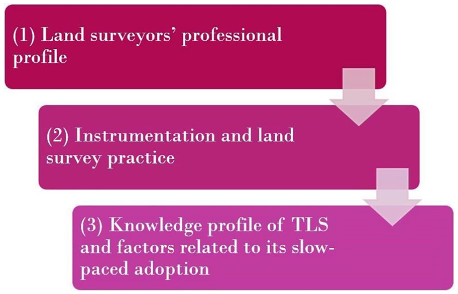
Development of capacity mapping model for the present research.
Method and data
In following the idea enshrined in the capacity mapping model, to answer the questions posed by this study, we used a semi-structured questionnaire to collect primary data from a sample of land surveyors (by this we mean registered members of the Nigerian Institution of Surveyors [NIS]) in Enugu in October 2019. The sampling technique was systematic in which the questionnaires were administered to 81 land surveyors from the total population of 102 SURCON-recognised land surveying personnel in Enugu. SURCON (Surveyors Council of Nigeria) is a statutory body – established by CAP 425 law of the federal republic of Nigeria (1990) – that oversees the surveying profession and the registration of surveyors in Nigeria. Based on SURCON registration guidelines, the composition of surveying personnel in Nigeria includes registered surveyors, pupil surveyors, technologists, and technicians. The sample size is consistent with an unbiased estimation model by Yamane (1967), which considers a finite population at a 95% confidence level and ±5% precision – refer to equation (1) below. The sampling did not include para-surveyors – persons trained to practise surveying, which, according to Mabogunje (2009), was part of the issues arising from Nigeria’s land reform policy of 1999. We chose Enugu as a pilot in this serial study that intends to cover the whole of Nigeria. Besides being one hotspot of land surveying practice in Nigeria because of the relevance of UNEC and ESUT in training land surveyors and geo-informaticians in Nigeria, Enugu is also the headquarters of south-east Nigeria and hosts several regional and national surveying professional fora. The maiden edition of the south-eastern surveyors’ forum, which was held 3–4 October 2019, gave sufficient impetus for choosing Enugu for this pilot study. The casual loop diagram in Figure 3 elaborates the various factors that formed part of the choice of Enugu for this study, and their interdependencies. Based on the diagram, arrow direction, line thickness, colour and polarity are main variables. A ‘−ve’ polarity and a red arrow means there is no contribution to the choice. A ‘+ve’ polarity and blue arrow means a positive contribution. A thin line means no effects, although the variables are implicitly significant.
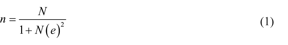
Where n is the sample size, N is the finite population, e is the precision level.
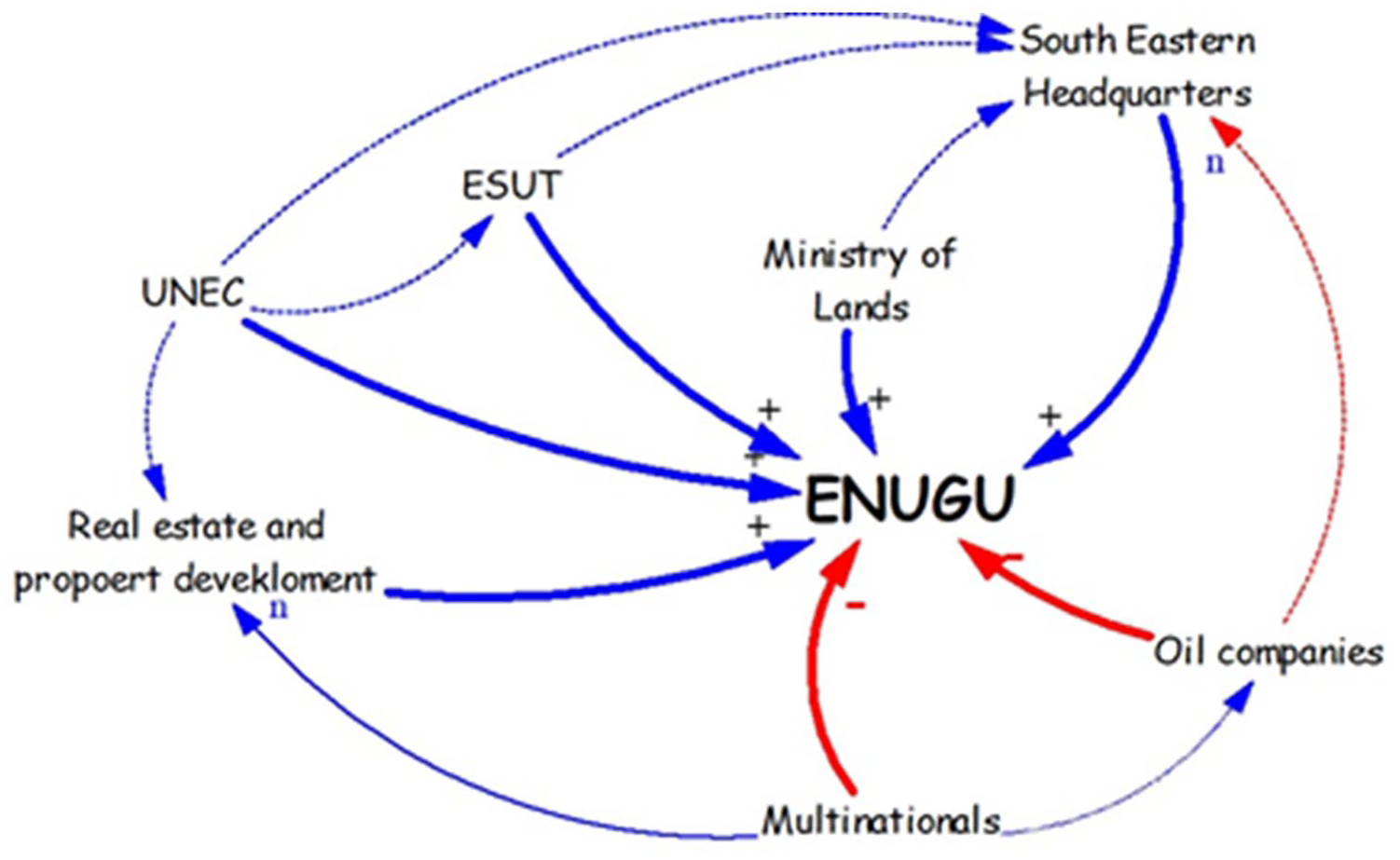
Casual loop diagram that elaborates the various factors that formed part of the choice of Enugu for this study, and their interdependencies. −ve polarity and red arrow means there is no contribution to the choice. +ve polarity and blue arrow means a positive contribution. A thin line means no effects, although the variables are implicitly significant.
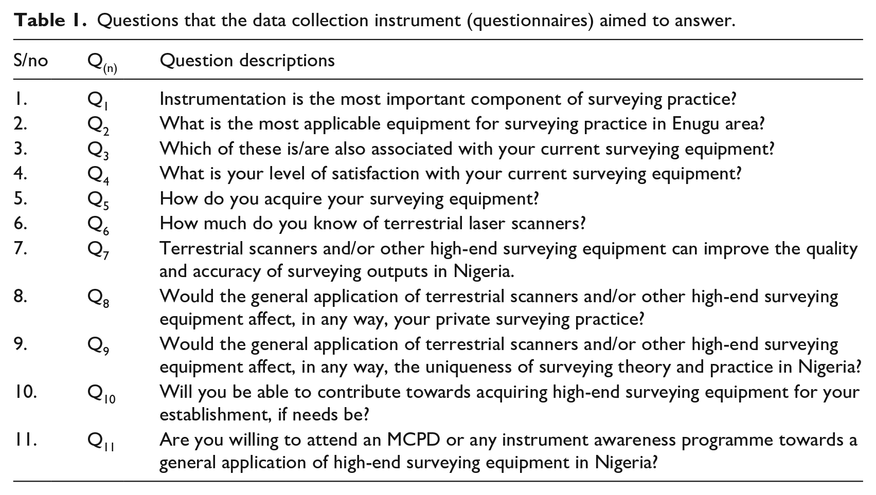
The questionnaire instrument was designed in English and aimed to test the key components of land surveying theory and practice and how these components determine the level of knowledge of TLS instrument among land surveyors in Enugu. Completing the questionnaire would take a maximum of 10 minutes. Participants in the research were expected to provide responses to enable the authors to evolve empirical evidence on the reality and professional profile of land surveying theory and practice in Enugu, the potentials and limitations of instrumentation within the theory and practice of surveying in Enugu, issues surrounding the adoption of TLS, and the surveyors’ participation in the overall decision-making for surveying instrumentation policies. The questionnaire contained questions such as: What is the most applicable equipment for surveying practice today in Enugu? How can you measure your level of satisfaction with your current surveying equipment? Which of these is/are also associated with your current surveying equipment? How do you acquire your surveying equipment? How much do you know about terrestrial scanners? Terrestrial scanners and/or other high-end surveying equipment can improve the quality and accuracy of surveying outputs in Enugu. Would the general application of terrestrial scanners and/or other high-end surveying equipment affect your private surveying practice? Would the general application of terrestrial scanners and/or other high-end surveying equipment affect the uniqueness of surveying theory and practice in Enugu? Are you willing to attend a mandatory compulsory professional development programme or any instrument awareness programme towards a general application of high-end surveying equipment in Enugu? Will you be able to contribute towards acquiring high-end surveying equipment for your establishment, if needs be? Suggest ways in which your institution/private practice can help to improve the current knowledge of terrestrial scanning equipment in Enugu. For ease of coding in SPSS, we used code numbers: Q1 to Q11 to represent these questions (see Table 1).
Questions that the data collection instrument (questionnaires) aimed to answer.
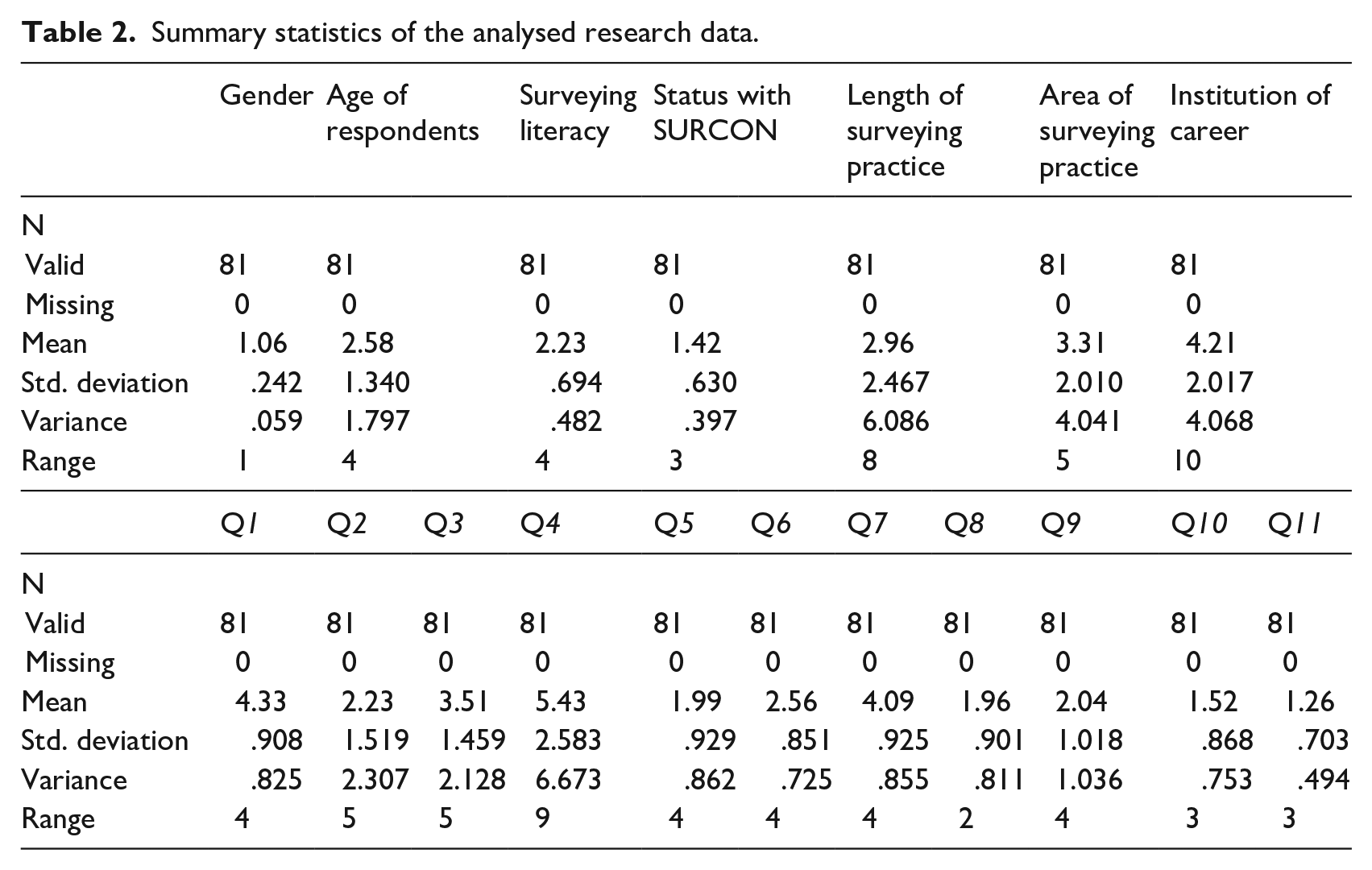
The authors participated in the data collection along with other data collection assistants. Although a systematic sampling technique was used, the willingness of each respondent to take part was also factored in. Each participant, being assured of their anonymity, was encouraged to provide as many candid and well-informed responses as possible. Authors and data collection assistants were willing to support the respondents in situations where any question needed further clarification. We present in Table 2 the summary statistics of the data collected and analysed. Tables 3 to 20 summarise the outcomes of the research and answers to the key questions.
Summary statistics of the analysed research data.
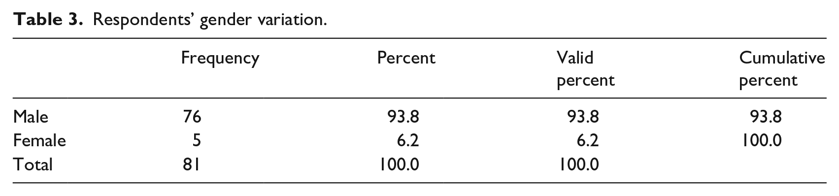
Respondents’ gender variation.
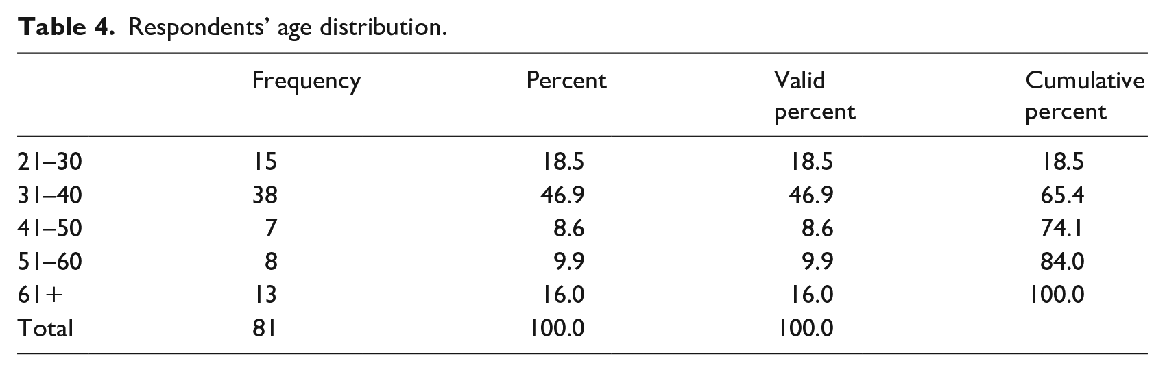
Respondents’ age distribution.
Respondents’ qualifications and educational attainment.
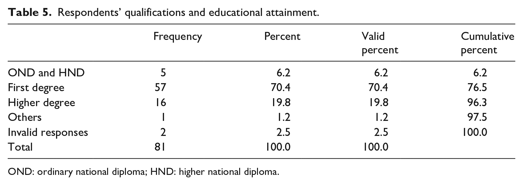
OND: ordinary national diploma; HND: higher national diploma.
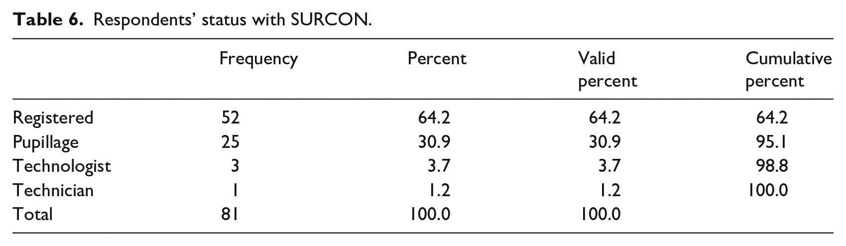
Respondents’ status with SURCON.
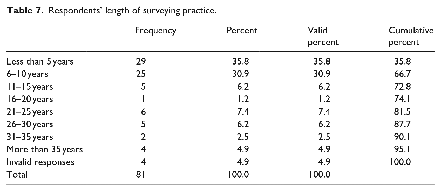
Respondents’ length of surveying practice.
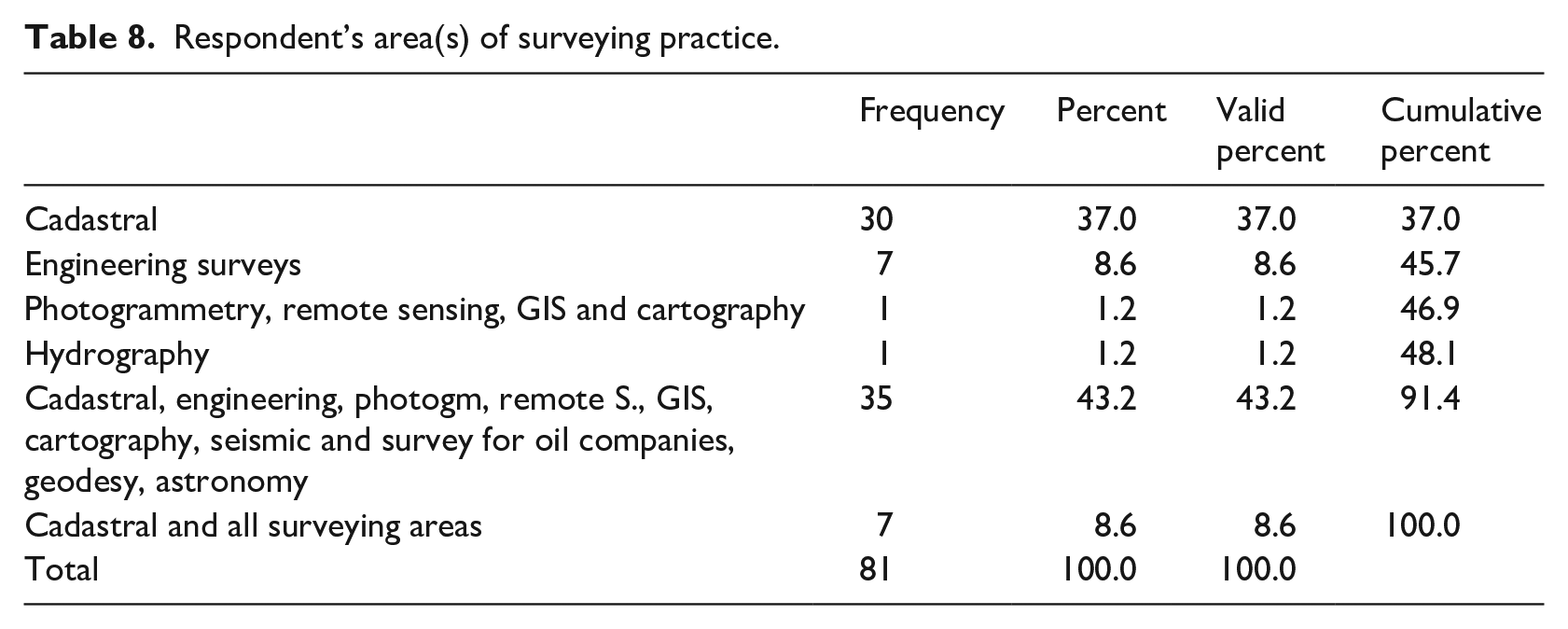
Respondent’s area(s) of surveying practice.
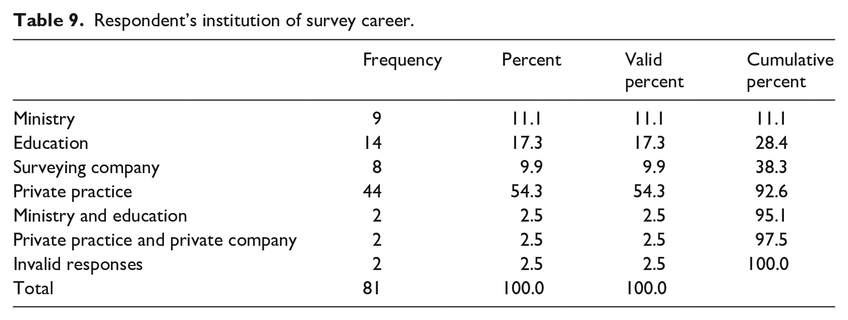
Respondent’s institution of survey career.
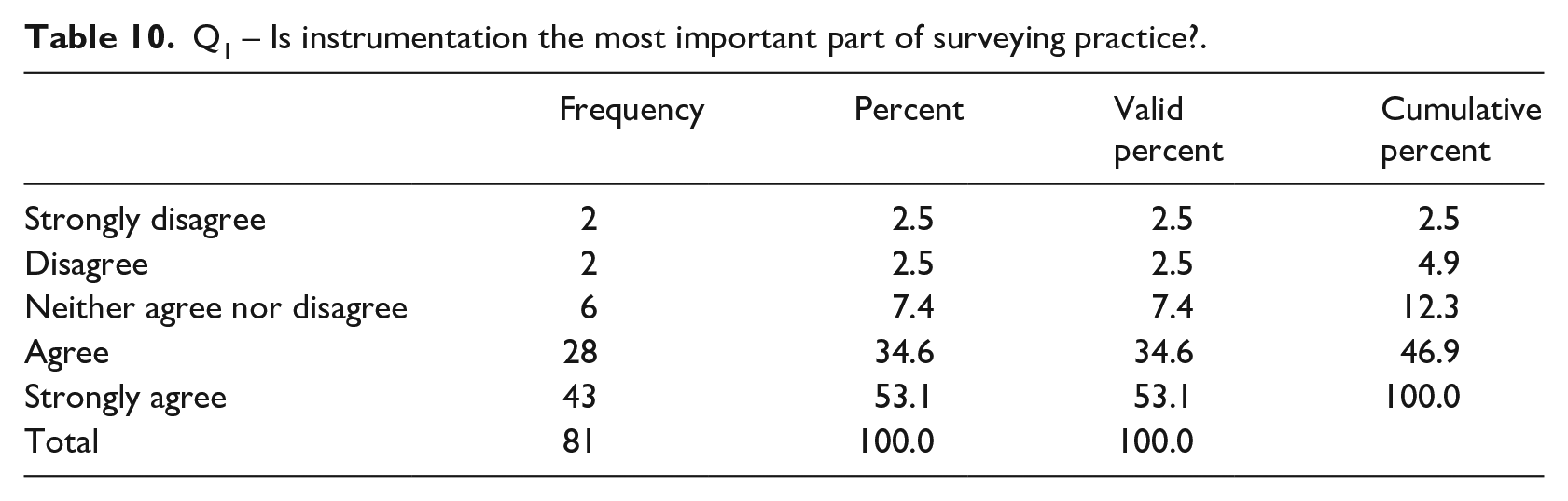
Q1 – Is instrumentation the most important part of surveying practice?.
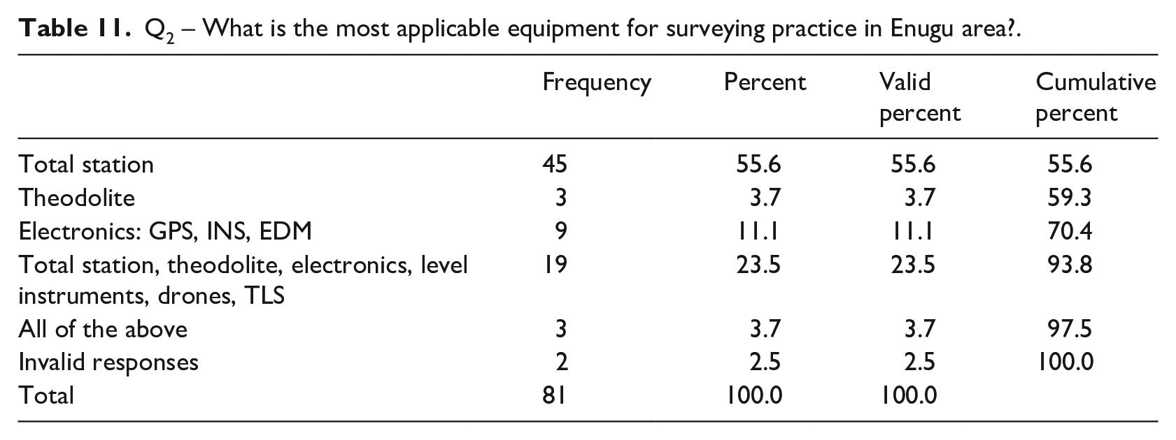
Q2 – What is the most applicable equipment for surveying practice in Enugu area?.
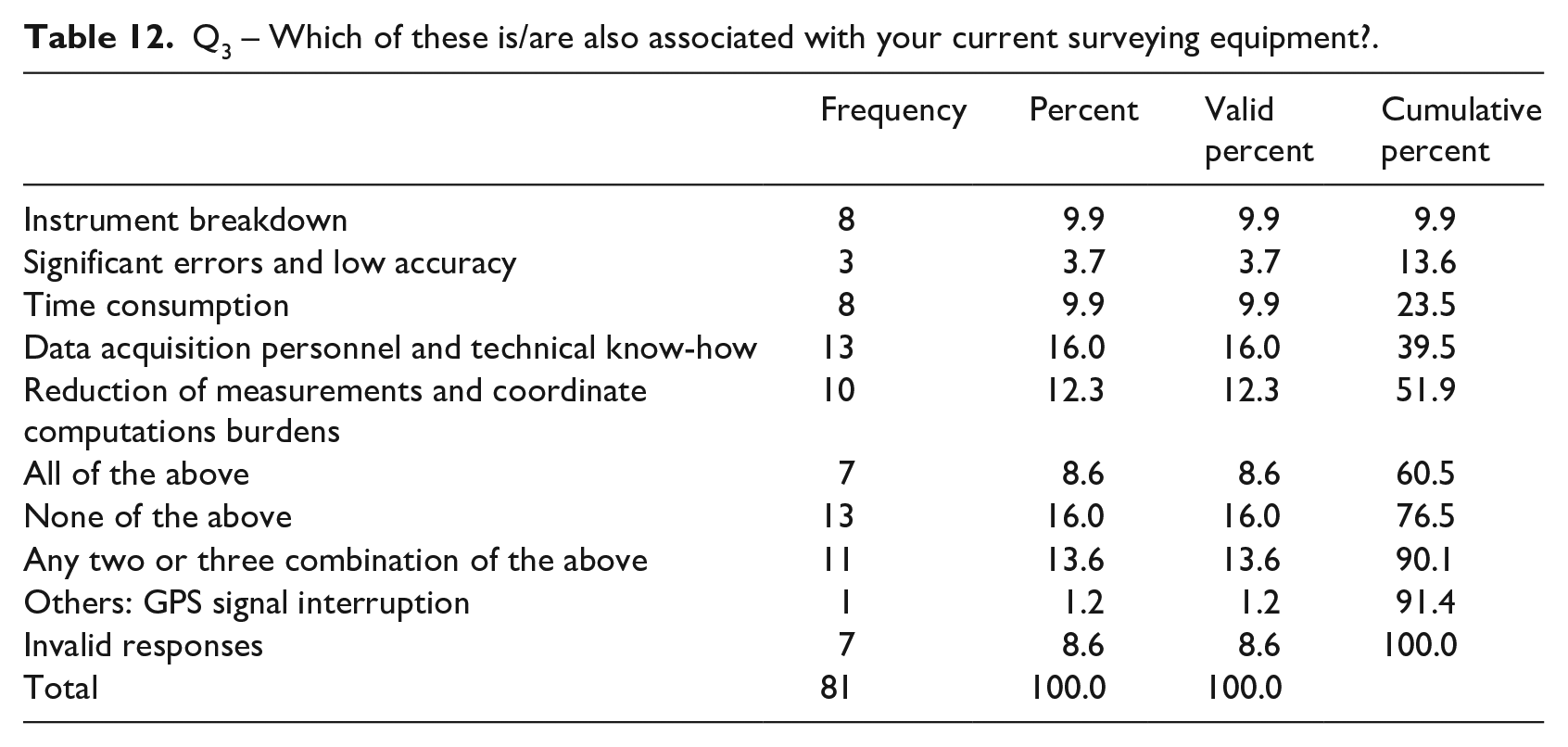
Q3 – Which of these is/are also associated with your current surveying equipment?.
Q4 – What is your level of satisfaction with your current surveying equipment?.

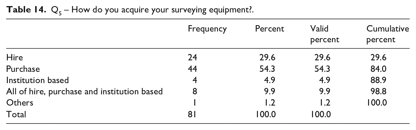
Q5 – How do you acquire your surveying equipment?.
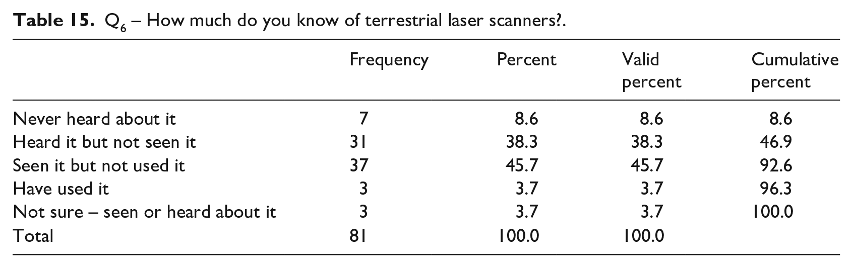
Q6 – How much do you know of terrestrial laser scanners?.
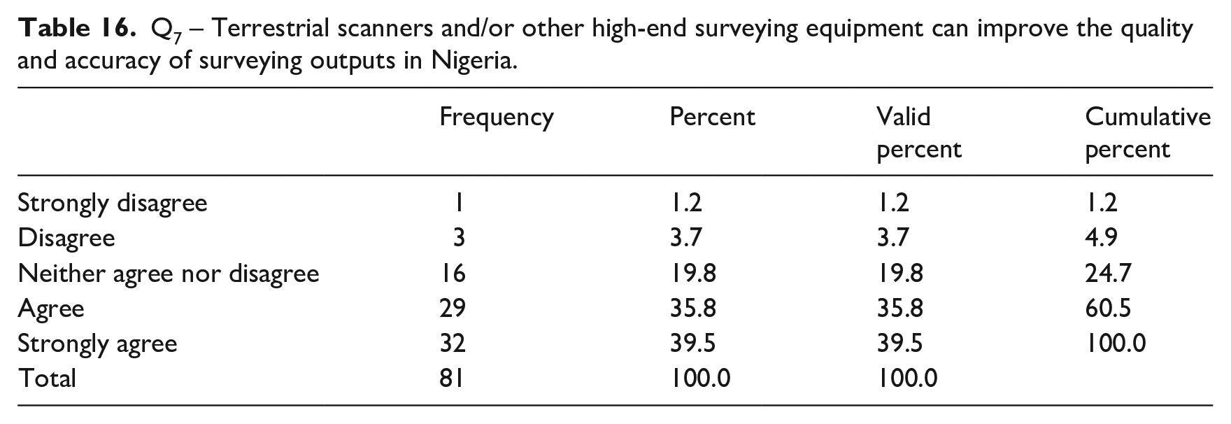
Q7 – Terrestrial scanners and/or other high-end surveying equipment can improve the quality and accuracy of surveying outputs in Nigeria.
Q8 – Would the general application of terrestrial scanners and/or other high-end surveying equipment affect, in any way, your private surveying practice?.

Q9 – Would the general application of terrestrial scanners and/or other high-end surveying equipment affect, in any way, the uniqueness of surveying theory and practice in Nigeria?.

Q10 – Will you be able to contribute towards acquiring high-end surveying equipment for your establishment, if needs be?.

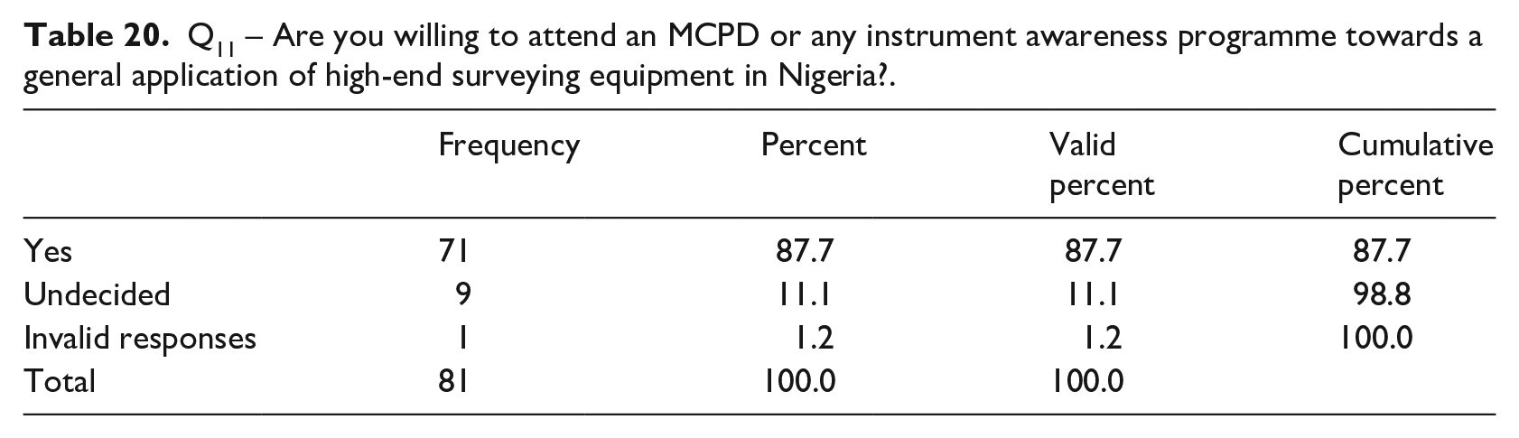
Q11 – Are you willing to attend an MCPD or any instrument awareness programme towards a general application of high-end surveying equipment in Nigeria?.
Results and discussion
The results of this study provide unambiguous answers to the questions that border on the need to grow the capacity of land surveyors in the DCs Developing Countries towards high-end technology. These results are empirical evidence on the actuality of the following: (a) professional profile of surveying theory and practice within the study area; (b) prospects and challenges of instrumentation in the theory and practice of surveying in the study area; (c) knowledge profile of TLS, the factors attributable to its slow-paced adoption and implications of the theory and practice of land surveying; (d) surveyors’ participation in improving the profession through adoption of high-end technology, especially the TLS equipment for surveying theory and practice in the study area. The results are carefully organised in six tables, in a way that they all captured various aspects of the study’s objectives. Tables 3 through to 9 represent the professional profile of surveying within the study area. Tables 10 through to 14 present issues relating instrumentation and their bearing in the study area, Tables 15 through to 18 focus on the TLS technology and its implications in the study area, while Tables 19 and 20 present cases of surveyors’ participation in the future development of surveying within the study area.
Starting with first key tables, the study reveals that 64.2% of the respondents have acquired a full surveyor’s registration with SURCON, while 30.8% are pupil surveyors who require a minimum of two years’ practice to secure their full registration. This adds up to over 90% of the respondents who are actively practising land surveying within the study area. SURCON registration, which is arguably a key prerequisite to knowledge of surveying theory and practice, offers a significant confidence to the internal validity of the research data within the study area. Besides, with 16% of the respondents who are aged 61 and above comes a great and rare blend of surveying experience, although such an age quotient increases the overdependence on more analogue equipment rather than digital. However, the main workforce in the case of surveying in Enugu is within the ages of 31–40, which makes up about 47% of the total respondents. This contributes to the dynamism, expected capacity and human capital needed within the profession to drive the capacity needed for the 21st-century smart surveyor. Most of the respondents possess first degrees (70.37%) and higher degrees (19.76%). The impact of educational attainments on the overall outcome of the research is that it reveals a great deal of spread of both theoretical knowledge and practical experience, both of which ease freely on acquisition of capacity and skill and this is what the study is primarily about.
Gender issue raises an obvious sentiment, which may have some effects on the overall spread of the data and empiricism of the study. A female (7.41%) to male (92.59%) response ratio of nearly 1:15 highlights an issue of primary concern within the practice of surveying and geoinformatics in the study area. We may perceive surveying as a male-gendered profession, but there is now an increasing consensus to improve the participation of females within the profession. Research of this nature, with a whole participants’ normal distribution skewed towards the male gender, points to the increasing need to fortify the crusade towards motivating more females towards joining the land surveying profession. Discussions relating to females in surveying is of global importance (Greed, 1990, 2006). In Nigeria, women in surveying (WIS) – a new academic direction and professional philosophy started in 2004 to promote women’s participation in land surveying – is now a hot research issue. Dialectically, it is hard to find a simple resolution to the question: is surveying a gendered profession?
Table 7 shows the length of practice of the respondents. Based on the data, over 35% of the respondents have practised for less than 5 years. Over 4% of the respondents have practised for over 35 years, whilst >30% have practised for the period between 6 and 10 years. Based on a measure of central tendency, the median length of practice falls within 10.5 years, which makes the number of respondents that have practised from <5 years to a time just above 10 years, to about 65% of the total respondents. The length of practice in this case suffices to give one some insights into what is likely to drive a passion for modern technology transfer and adoption. Arguably, present practitioners, made up those who have been practising for shorter periods of time, are more likely to have a wealth of experience in modern equipment and technology. They possess a greater propensity and willingness to gain skills for modern surveying equipment. This is an interesting discovery that this research makes regarding assessing the willingness and likelihood for human capital investment, instrument training, and skill acquisition.
Regarding surveying experience, and the spread of practice within the study area which is one of the key determinants of the present research, the data in Table 8 reveal a wide range of practice – cadastral and engineering surveys, respectively, are supported by at least 37% and 8.64% of the respondents. A negligible number of the respondents (1.23%) agree to practising any of hydrography, photogrammetry, remote sensing, geographic information system (GIS) and cartography. A good number (>51%) claim to combine cadastral survey with all other areas of surveying, including seismic and survey for oil industries, geodesy and astronomy, cartography. For this study area, these pieces of evidence show that cadastral survey is the dominant surveying practice. This is an interesting fact that not only resonates with the culture and theoretical framework of surveying in developing countries, but also shows the rate at which surveying practice lags behind advancement in geoinformation ideology globally. In fact, with these findings, it is arguable that despite all its aspirations and motivations, surveying practice in Enugu and Nigeria is still within a primitive professional framework. Thus, it is necessary that the present aim of examining gradual adoption of high-end technology should also explore why an age-old profession has failed to reach global significance.
Regarding the professional profile of surveying, Table 9 shows that most of the respondents are in private practice (54.32%), while some are working in the ministry (11.11%) or in education (17.28%) where they take part in research and in training of surveyors. Very negligible numbers of the participants combined working in the ministry and engaging in research and surveying education (2.47%). Similarly, few people combined private practice with working in corporate organisations (2.47%). None of the participants worked in construction or multinational companies. The prevalence of private practice in the study area raises one key question, which is: ‘How does private practice impact the future of surveying in Nigeria?’ Whilst this question may be beyond the scope of this study, it is important to reinstate that the key determinants of surveying professionalism in the study area are service, ethics and mandatory continuing education, and these are regardless of the number of people in the practice.
A general knowledge of the land surveying instruments and their applicability in surveying operations is fundamental to assessing the actual professional profile of surveying within the study area. Table 10 provides a critical framework to assess this knowledge. Many studies have shown that surveying instrumentation has a significant impact on the overall practical wellbeing of the profession (Abd-Elrahman et al., 2019; Burkholder, 2005; Nguyen and Weinand, 2020; Trinder and Han, 1999; Williamson, 1997). These studies provided empirical evidence to show the real potential of instrumentation in surveying practice within various places in the DCs. From the responses shown in Table 10, over 80% of the respondents either agreed or strongly agreed that instrumentation is the most important component of surveying operation in Enugu. As a geoinformation science, land surveying focuses on geospatial data, which must meet certain accuracy criteria and specifications optimised practically within a project cycle. Respectively, more than 55% of the respondents and another >24% of the respondents agreed that total stations alone and in combination with other land surveying equipment are the most applicable surveying equipment in the study area (Table 11).
However, despite the list of worries associated with current surveying equipment, which include (Table 12) data acquisition personnel, technical know-how, time consumption, and instrument breakdown, the level of satisfaction, which nuances from just satisfied (>43%) and very satisfied (>24%), is high, as shown in the Table 13. This is close to the expectation of a profession that allocates over 50% of its project budget to data collection (Heipke, 2010), given that surveying – which is a geoinformation operation – is basically about collecting spatial data. Without looking into why some respondents feel there are other components which are more important than instrumentation, but looking at the general view of these respondents, personnel might be worth mentioning as also important. Therefore, the TLSs which require a minimum of personnel compared with the traditional land surveying equipment are gaining increasing importance in geospatial applications.
Table 14 reveals that most of the land surveyors in Enugu either purchase or rent survey equipment. Over 50% purchase their equipment, and 29.63% rent their equipment. About 5% use their institution-based equipment. This seems like a very common practice among surveyors in Enugu, and it goes a long way to enhance the practice of the profession. About 10% claim that they apply all three methods of renting, purchase, and institution-based in their acquisition of surveying equipment. Despite the highly acclaimed potential of TLSs, Table 15, which summarises the current knowledge of TLS in the study area, reveals a reasonable level of perception, although poor practical experience prevails. In the present research, we applied the senses of ‘seeing’, ‘touch’, ‘hear’ and ‘using’ as a measure of instrumentation perception. Here, 8.65% of the respondents said that they have never heard about the instrument, 38.22% said that they have heard about the instrument but have not seen it, 45.68% have seen the instrument but never used it, while only just a little above 3% have used the equipment (i.e., heard about it, seen it and applied it practically). The last 3% is unsure of their perception of the TLS.
From Table 16, over 60% are of the opinion that TLS will improve the quality and accuracy of surveying operations in Enugu, although >39% strongly agree with this view. About 20% of the respondents are unsure of their answer. However, with what we already know about the general operation of the TLSs, they can improve the surveying status of practice in Enugu. Despite these outcomes, only about 42% thinks TLSs and other high-end surveying equipment can affect the uniqueness of surveying theory and practice in both their private practice and in the general theory and practice of surveying within the study area and in Nigeria (Tables 17 and 18).
The respondents were asked if they would contribute to acquiring high-end surveying equipment. Tables 19 and 20, respectively, show that 71.6% agreed, and 87.65% agreed that they would attend any MCPD organised by the state towards a general application of TLS and other high-end surveying equipment.
The findings of this study’s primary data analyses support the view that land surveying practice in developing countries lags behind the global expectations of professionalism. With the rapid collapse of boundaries of various professions in the world, providing an ample impetus for multi-disciplinary approach to societal problems, the sustainability of the land surveying profession now faces much uncertainty. Akpee et al. (2016) identified societal changes and technological advances as key drivers of land surveying practice, although the slow-paced adoption of high-end technology in developing countries raises the odds associated with the sustainability of the land surveying profession. TLS, the focus of the present study, which fits the profile of technological advances, is aimed to enhance the value of land surveying in terms of applicability and societal relevance. However, given the poor knowledge of these instruments, and being rarely used, creates a yawning research interest in the areas of land surveying. Extant discussions in the literature covering various places within the developing countries – in Africa, Asia and the Caribbean – confirm that cadastral, land administration and land management are now the preoccupation of land surveying practice (Durand-Lasserve and Selod, 2009; Nuhu, 2019; Williamson, 2001). Still, these operations lack the sufficient and necessary impacts of global scientific innovations and modern technology that changes the instrumentation ideology of land surveying.
Evidence from the literature shows the application of modern techniques and ideologies in dealing with land-related issues within the global sphere, for example, four pillars of digital land resource mapping (Ringrose-Voase et al., 2019) and statistics-based modelling for exploring the land use changes in Eastern Poland (Noszczyk et al., 2020). Hypothetically, these techniques are far from the basic principles and ethos of the traditional land surveying techniques which we are trying to advance, and further buttresses the idea of relevance in a world of collapsing professional boundaries. Land surveying collects data, but the present societal geospatial data needs – with a great deal of emphasis on big data, analytics, management and dissemination – overwhelms traditional land surveying. Thus, practitioners of land surveying face the risk of exclusion from participating in the recent land-related activities, and this would necessitate a deliberate conforming with the skills and capacities applicable to geoinformation.
It is on the basis of this necessity that this study discusses the relevance of TLS technology and how it can aid a strategic improvement in the present surveying theory and practice if land surveyors can adequately embrace the technology. TLS enables experts to obtain fast and accurate geospatial details of the Earth’s features, and therefore creates a useful link between geospatial infrastructure and the teeming needs of big data for a myriad of societal applications (Walsh et al., 2018). TLS produces point clouds which enhance topographic mapping and the creations and validation of quality land surface models – DEM, DTM, DSM. These prospects imply that TLS technology will still serve the purpose of future data gathering, and will therefore be convenient for land surveyors aiming to overcome the challenges that accompany the traditional surveying techniques, which is mostly time-consuming with frequent rigorous instrument and error adjustment.
Conclusion and recommendations
This research examined the potential and limitations of modern technology adoption in the theory and practice of land surveying in developing countries. It specifically considered the terrestrial laser scanners (TLS). The primary aim was to investigate the factors related to their slow adoption of advanced technology for land surveying operation in developing countries, and implications for future development of the land surveying profession. This study offers the first empirical evidence on the widely held view of poor knowledge of high-end instruments, and cadastral dominance in land surveying operations in developing countries. This is significant for policy and research towards innovation and land surveying professional development. We combined secondary data with primary evidence from Enugu, Nigeria in West Africa, which is an influential area of land surveying practice within the context of a developing country. Grounded on capacity mapping model, the research used a quantitative approach to administer semi-structured questionnaires systematically to 81 out of 102 land surveyors in Enugu recognised by the SURCON (surveyors council of Nigeria). These questionnaires contained a combination of closed and open questions aimed at collecting aspatial data from the land surveyors regarding the main rationale and the key objectives of the research.
With statistically significant outcomes from the general academic and professional background of the respondents, the length of surveying practice, general spread of experience and practice, and awareness of surveying equipment and application, the results of the research show that there is a strong professional profile of surveying theory and practice in the study area. However, despite the list of problems associated with the present instruments for surveying practice, which include instrument breakdown, significant errors and low accuracies, data acquisition personnel and technical know-how, the overall level of satisfaction with the status quo in terms of instrumentation for surveying theory and practice still seems appreciable. One wonders why the situation is the way it is and why it has not become an issue for scientific investigation.
The results show that any change in terms of technology transfer and adoption is a major catalyst for research and therefore underlines the critical importance of the present study. Just about 3.7% of the respondents agreed to have used the terrestrial scanning technology. Most of the respondents (>38%) have either heard about the technology and not seen it, or (>45.6%) seen it but not used it. Based on the research findings, the slow pace of technology transfer and adoption relates to the dominant surveying operation in the study area, which is mainly cadastral surveying and land information management (LIM). Other attributions are limited funding to acquire modern equipment, and poor technical capacity, which the major limitations with the current instrumentations in the theory and practice of surveying in Enugu revealed. Most land surveyors in Enugu think they do not require terrestrial scanning equipment or other high-end surveying equipment. This situation literally and arbitrarily presents a mean future for the surveying profession in the study area and thus calls for both policy, political and academic discussions. However, these same land surveyors agree to be part of funding or any instrument policy which will enhance the present and future professional profile of surveying theory and practice in Enugu.
This study highlights the importance of instrument training as part of the routine mandatory continuing professional development of surveyors within Enugu, whilst authors argue that much development in the professional profile of land surveying is subject to compliance with current global professionalism, which is possible only if the competence of more resident surveyors is skewed towards adoption of modern technology. This will check the declining prospects of surveying in Enugu, which also touches issues on women in surveying (WIS) and the general geoinformation framework of land surveying in Nigeria. However, this research is limited to Enugu. There is a strong possibility that the findings, including logical and empirical conclusions, may be different if we considered the research from a more overarching context, such as using the whole of Nigeria or the south-eastern region. The issues that will arise from extending the research beyond the present context will be essential in nuancing professional standards in a way to meet global expectations. We therefore recommend these ideas for future studies.
Footnotes
Declaration of conflicting interest
This research did not get the support of any public research funds. However, its motivation came from various calls to propose research which the Nigerian national budget will fund to address the declining technical capacity and human development deficiencies in various academic discourse in Nigerian university. Hence, the authors acknowledge the government of Nigeria for its skill and knowledge intervention policies and research initiatives. The authors would like to acknowledge specifically the work of numerous authors in land surveying, geodesy, geospatial science and analyses, and environmental systems and sciences. Finally, we appreciate the incisive and valuable input from the handling editor and anonymous reviewers.
Funding
The author(s) received no financial support for the research, authorship, and/or publication of this article.