
Abstract
Using the example of neotoponyms proliferation in Tokombéré (Northern Cameroon) between 1970 and 2011, this paper questions the banal tactics of naming places as a site of public patriarchy contestation. In fact, young people play a crucial role in reinventing local political power forms of interpellation, which enables them to symbolically reappropriate the space. This helps to establish their presence in the public sphere from which they have been side-lined by social elders. Even though it reflects a political expression, the fact remains that the attribution of toponyms does not really help to reverse their domination into social field.
Introduction
This paper analyses the banal naming practices of Tokombéré neighbourhoods as an act of resistance to local authorities between 1970 and 2011. This situation echoes a context marked by the perpetuation of public patriarchy (Mouiché, 2007: 391), which has strongly contributed to the marginalized status of youth, with cultural and political basis (Comaroff and Comaroff, 2005; Cruise O’Brien, 1996). Consequently, young people 1 are to be understood in a relationship of dependence with social elders without being deprived of their agency (Fokwang, 2016: 213). This situation encourages the latter to opt for ‘poaching form’ (Abé, 2011: 141), understood as a strategy for thwarting the control of power, and which has the effect of leading them to a political expression ‘at ground level’ (Abé, 2011: 142). This reflexion is part of ‘politics from below’, 2 in order to define banality as ‘an attempt to understand the historicity of politics enunciatively’ (Bayart, Mbembe and Toulabor, 2008: 11, 13), which means to understand politics outside the places ‘conventionally’ recognized by the standards of political science. It is also rooted in cultural geography through the articulation between social representations and spatial practices (Claval and Staszak, 2008: 3), by identifying how young people’s way of being (culture) enables them to formulate a critical discourse that takes shape around neotoponyms 3 in Tokombéré. In this sense, the act of naming places, an act that is first of all harmless, should be seen as a form of territory’s appropriation, as demonstrated by reflexions in Francophone area (Ben Arrous, 2009; Bopda, 2001; de La Soudière, 2004; Garakcheme, 2011; Giraut and Houssay-Holzschuch, 2008; Guillorel, 2008; Leimdorfer et al., 2002; Nissabouri, 2006; Njoh, 2010; Siblot, 2006), as well as the English-language trend of critical toponymy, which is based on comparative studies in former settlements and highlights the relationship between analysis of place names and study of power (Alderman, 2008; Berg and Vuolteenaho, 2009: 6, 12; Bigon, 2016: 2–3; Bigon, 2020; Bourdieu, 1979: 79; Giraut and Houssay-Holzschuch, 2016: 4; Njoh, 2017; Njoh and Chie, 2019; Rose-Redwood et al., 2018: 457). Thus, the central question is how are neotoponyms indicators of the Tokombéré’s youth response to their marginalization from the public sphere by local authorities? How do neotoponyms contribute to the political expression of youth in Tokombéré between 1970 and 2011?
The analysis focusses on the way in which the mutation of toponyms in Tokombéré reflects young people’s distrust of gerontocratic power. I postulate that the Tokombéré youth participate in public debate and express their political opinion through the neotoponyms of neighbourhoods. I factor in the point that attribution of a toponym can be seen as a form of political expression because ‘the appropriation of space goes through its naming [because] there is no such thing as a nameless place, and the same place can have several names simultaneously or over time’ (Lima, 2008: 14). This phenomenon is part of discussions on the construction of public sphere in Africa. In fact, political practice relates to ideals of participation and representation that are favourable for the constitution of a political community (essentially a dialogical space) where action is only possible through performative utterances (Bidima, 2009: 127). From this perspective, the political participation of youth in Tokombéré involves the quest for freedom of speech in social field (Sindjoun, 1996: 57). However, the public sphere in Africa is dominated by social elders who govern. For this reason, it is necessary to consider generational time, 4 which analyses how different age groups engage in sociability (Holtedahl, 2010: 122). The ruling by elders gives them the right, within the framework of municipal policies, to create new territorial units, particularly through subdivided territorial extensions. This gridding of space ensures not only its control, but also its inhabitants’ movements – therefore, it constitutes a discipline apparatus. The popular neotoponyms of youth inspiration constitute in this perspective an act of resistance, a form of escape from control (Lefebvre, 1991). It proceeds to deconstruct the ‘panopticon’ that has been put in place, particularly through the official toponymy of settlement areas in Tokombéré. It should be noted that Tokombéré is an interesting case study because of its cosmopolitanism, a place where mountain and lowland dwellers meet, a population of Christians, Muslims, and Endogenous Religions. This situation was created by the history of human migrations and resistance to territorial conquests of Islamic peoples (Mandara and Fulani).
The work is based on an inductive thematic analysis following field research since 2012 in Tokombéré. Private interviews and focus group discussions were conducted with members of youth associations (Association des Jeunes Élèves et Étudiants de la Faada [Association of Young Students of the Faada] – AJEEFA), amateur football clubs (Tout Puissant Bariky [Almighty White] – TPB) and missionary educational institutions (Foyer des Jeunes de Tokombéré [Tokombéré Youth Centre] – FJT); administrative, endogenous and political authorities (former mayors, village chiefs, etc.); key actors of the Projet de Promotion Humaine de Tokombéré [Tokombéré Human Promotion Project] – PPHT (doctors, missionaries, etc.) and urbanites of some Tokombéré neighbourhoods. A non-participant observation was also carried out and material was used from archives of Divisional Delegation of Cadastre and Land Affairs in Mora, Private Hospital and Saint Joseph Parish in Tokombéré (Kudumbar newspaper, map of the Margui Wandala, health and parish sectors of Tokombéré maps, etc.) (Figure 1). All these resources made it possible to present the study in two sections. First, I historicize the actors at the base of territorial naming in Tokombéré’s urban centre through presentation of the process from popular action to official recognition by municipal authorities. Second, I address the popular spatial marking performed by youth in Tokombéré as an act of resistance with political connotations towards authorities.

Tokombéré health district corresponding to the subdivision limits (© Tokombéré Private Hospital).
Neighbourhood’s names and actors of urban toponymy in Tokombéré
Toponymy, traditionally linked to onomastic and linguistic, allows deeper understanding of interactions in social field. The naming of territories is generally the preserve of state authority, which guarantees spatial organization (Audebert, 2008), as the case of Cameroon’s qualification of spaces at the level of regions, divisions and subdivisions easily shows (Bopda, 2001). Since Circular No. 8/CAB/PR of 19 July 1971 on the naming of arteries and squares in towns, the State has transferred the competence to make toponymic inscriptions to municipalities (Bigon and Njoh, 2013: 12). However, this task is sometimes the result of a negotiation between population and authorities because of stakes involved in appropriation of territorial entities (Lima, 2008: 14).
On popular action as framework for the enunciation of toponyms
The choice of ‘place name’ in Cameroon is incumbent to state authorities. At lower levels, especially within cities, this prerogative is shared between population and local authorities, as demonstrated by the case of Tokombéré neighbourhoods. 5 In fact, it has been noted that a large majority of territories’ names stemmed from popular inspiration, which means that it emanates from the daily uses made by inhabitants to find their way around, before municipalities ratify them through the act of formalization. 6
First and foremost, it should be pointed out that Tokombéré settlement is the result of migratory movements caused largely by colonial and post-colonial policies restricting population from coming down the mountains (Garakcheme, 2011: 4; Rémy, 1972: 503) from the 1940s and 1960s onwards, although scarcity of foods led to displacements in the early 1930s. The missionary actions, through the foundation of Catholic Mission by Father Simon Mpecke and a health centre by Doctor Giuseppe Maggi from 1959 onwards, played a role in voluntary displacement of mountain dwellers towards the plain, particularly to deal with epidemics such as smallpox (1951–1952 and 1961–1962) (Seignobos, 1995: 150). The emergence of new somewhereness extending the site of ‘traditional mountain village’, by projection onto foothill (Boutrais, 1973: 53, 70, 120; Rémy, 1972: 501, 503–506), is the first consequence of this movement. This extension takes a common toponym (Baker, 2008: 1): dala (village) and specifies the community that inhabits it. Therefore, to indicate the part of plain below the mountain inhabited respectively by Zulgo and Mada communities (Hallaire, 1991: 72), dala Zulgo or dala Mada are frequently used.
Faced with demographic growth in mountains and gradual establishment of Tokombéré town, a greater projection of these ‘foothill villages’ is taking place towards the inner of the plain. The populations settle by community affinities (Garakcheme, 2011: 5), very often with the intention of reproducing the traditional mountain village. The rise of the denomination Talla (neighbourhood), an ethno-community term for urban neighbourhoods such as Talla Amada and Talla Wandala in Mada and Makinlingaï cantons respectively, is thus observed. As a result of increasing urbanization and various population’s migratory movements in the early 1970s, some neighbourhoods bear the name of the first inhabitant, such as Talla Nduel, Talla Laki or Talla Kayamgali in Makinlingaï, Mada and Palbara cantons. It should be noted that the totality of these names includes variable of masculinization, thus confirming both the patriarchal nature of endogenous mountain societies and, above all, the fact that women do not own the land (Hallaire, 1991: 41; Njoh et al., 2017; Zuvalinyenga and Bigon, 2020: 6). In addition, one can note the inclusion of local natural landscape elements, such as Gavaliam and Ourem neighbourhoods. All these popularly inspired names receive, for some of them, a legal recognition by municipal authorities.
Municipal authorities, recognition of popular toponyms and neighbourhood’s names formalization
It is noted that when it comes to the naming of neighbourhoods, municipality becomes a second-tier actor in Tokombéré. Although the spatial division of the town was made by allotment from 1983 onwards,
7
it proceeded much more by ratifying names given by population. This formalization takes place at three important moments: administrative/political tours, population censuses and electoral registrations. These are generally carried out by sub divisional and municipal authorities, by census agents and electoral bodies. The production of reports and administrative/political documents, civil status documents (birth, marriage and death certificates; land and building titles) established a database and allowed the official disclosure of urban spaces names from popular inspiration. As it allowed for individuals’ registration, these moments contributed to the reinforcement of control over the population through the territory’s mastering. The latter is achieved through gridding and organization of the territory, as described by Michel Foucault (1977: 195) analysis of the Black Death’s cantonment. Therefore, this need for control can be explained by the fact that The borders legitimized by political power qualifying [. . .] the neighbourhoods coexist with the unofficial borders drawn by lived and inhabited areas, but whose ethno-cultural dimension is sometimes after all institutionally recognised by the local authorities through formalization of place names (the translation is mine). (Audebert, 2008: 57)
The authorities generally recognize popular toponyms. The various diocesan tours, religious sector meetings or hospital consultations and the creation of health sectors are other moments of census and disclosure of popular names. This process has thus led to the town of Tokombéré being delimited into nine large urban areas which are the neighbourhoods of Bariky, Gavaliam, Kampala, Louganda, Mandara, Marché, Ourem, Talla Nduel and Talla Amada (Figure 2).
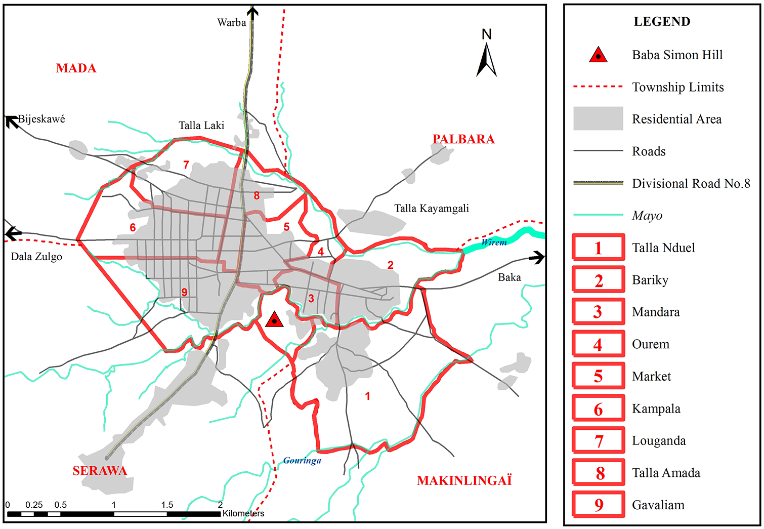
Borders of the nine large neighbourhoods of Tokombéré town (© Jeelin G. Baskouda).
Rise of local authorities recognized toponymy: The ‘official’ names of main Tokombéré 2 neighbourhood 8
Located in the plain formerly called Kudumbar, the town of Tokombéré occupies four of six townships of the subdivision, namely: Sérawa, Makinlingaï, Mada and Palbara. It is crossed by a road that connects it to national road No. 1 (Maroua–Kousséri section) from Makinlingaï to Warba. From the entrance to this road at Makinlingaï, one encounters the Bariky neighbourhood from the Private Hospital to the subdivisional Inspection of Basic Education offices at a junction in the town. Bordered on the east of the latter neighbourhood, on the side of St Joseph Primary Private School, in the direction of the Muyang foothills as far as Wirem mayo, which separates it from Talla Kayamgali, one meets Ourem whose most important space is the weekly millet wine market place called lamoorde 9 (Figure 3). In the opposite direction, at the western edge of the Bariky neighbourhood, after the mayo 10 that divides the town into two, one meets Talla Nduel where one finds Baba Simon hill and a small periodic market of wine and various doughnuts called Dangouala. It is bordered by another river further on called Gouringa.

Laamoorde wine market, Tokombéré (© Author).
The town spreads out with the Mandara neighbourhood to the north of the Bariky neighbourhood towards its centre, and it extends on both sides of the town’s main artery and reveals the central mosque and commercial establishments (garage, office secretariat, call-box, etc.). It extends from the Tokombéré Public Primary School to the edge of administrative centre, which is easily identifiable by plethora of public buildings (town hall, subdivisional office, gendarmerie company, CPDM party house, etc.). Next to it, it is easy to notice the marketplace, the municipal football field, the grandstand of the festival square in the Market neighbourhood. The description of the town continues towards the road that leads to the national road No. 1 through Warba, in direction of Talla Amada, which extends from the junction with one of the market entrances to the intersection between the main road and the fork in road to Kolokoch village (Figure 4). A few kilometres away, on the two sides of main road, Louganda and Talla Laki neighbourhoods are identified respectively, which marks the end of the town. Another neighbourhood, located behind subdivisional office, is called Gavaliam near to which Government High School Tokombéré is located and extends northwards towards Dala Zulgo and westwards towards the village Sérawa. It is bordered on the east with the Kampala neighbourhood, which extends to rear of Talla Amada and is bounded by the village Bijeskawé to the north. However, it must be emphasized that these various toponymic designations are part of a precise imagination that allows a better understanding of the meaning of toponyms in Tokombéré.
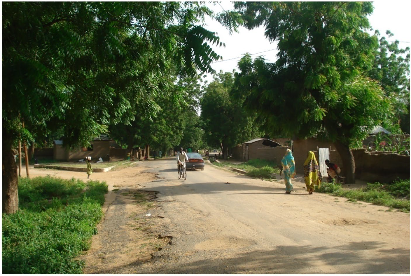
Main street of Talla Amada neighbourhood, Tokombéré (© Author).
Rise and nominal scalability of Tokombéré neighbourhoods
Giving a name to a territory, as highlighted above, is a highly symbolic and practical act. It contributes to appropriation and social marking of this space (Giraut and Houssay-Holzschuch, 2008: 9). It is therefore possible, through the analysis of changes in the naming of territories in Tokombéré, to perceive the political expression of youth through various neotoponyms they give to intra-urban spaces.
Youth, territorial’s spaces naming and political expression in Tokombéré
The main observation on socio-political life in Tokombéré is that youth use the re-naming of urban spaces to express their perception of public sphere. Territorial recomposition, a moment of hegemonic struggle, is established through the process of naming, which sets in motion both symbolic capital and resistance (Alderman, 2008: 196) to local power. Youth operate a non-material delimitation of territories through rejection or acceptance of historical social world (Castoriadis, 1987: 167–168; Mbembe, 2001: 103) proposed by social elders, in the context of defining an urban nomenclature. Thus, a fragmentation of urban territories is observed, or sometimes a conservation of the limits imposed by administrative and political authorities through the use of ancient toponyms, as in the case of Abidjan neighbourhoods in Ivory Coast (Leimdorfer et al., 2002: 236, 248).
On the fragmentation of neighbourhood space as mode of symbolic territory’s appropriation
The new urban delimitation in Tokombéré is carried out, on one hand, through the youth settlements and, on the other hand, through the setting up of an imaginary city from the 1970s onwards. It is performed through the granting of new spatial names to some areas of main neighbourhoods. These neotoponyms thus lead to the overlapping of names and the creation of a new symbolic space for youth, or even a superimposition of pre-existing toponyms, thus allowing the development of ‘shared mental imageries’ of the city, as in the case of the urban centres of southern Cameroon (Bigon and Njoh, 2013: 10–11). Through this act, they proceed to fragment, identify, and appropriate a portion of urban space. Moreover, they question boundaries and configuration that have been officially fixed.
A fraction of the Bariky neighbourhood located behind the presbytery and the Tokombéré Youth Centre, Douala neighbourhood was identified and progressively promoted around 1970 by young people, former residents of the boarding school created by Fr. Mpecke. This toponym has its roots in the great interest shown for southern Cameroon by youth of that time. 11 Douala, a port city considered to be the ‘economic lung’ of Cameroon, is a modern and cosmopolitan urban centre identifiable by its multi-ethnic and multi-faith character. It has been in the past, and continues to be today, a bastion of political opposition in Cameroon. For these youth, it reflected the gap between them and the rest of population, who had no access to education. Moreover, the young mountain dwellers at boarding school, who had been mocked by their parents when they opted for Western education rather than husbandry (Baskouda, 1988: 42), had subsequently developed a mind-set of superiority towards unschooled population. They were then perceived as ‘middlemen’ (Austen, 1983: 1) or ‘évolués’ (evolved) (Ndjio, 2008: 207), not only because of intermediaries’ role (mountain guide, translator, etc.) they very often played between missionaries and mountain dwellers, but also because of the education that predestined them to become a social elite, as underlined by Fr. Mpecke testimony to mountain priest Nglissa of Muyang: ‘See these children! They are all capable of expressing themselves in front of anyone, even the commander, because they can speak French’ (Baskouda, 1988: 129).
Another origin of this name would come from the strong presence of missionaries from Douala or from the ‘Bassa land’, such as Baba Simon and some nuns who were authorized by Mgr. Yves Plumey (Archbishop of Garoua 1955–1984) to work in the area (Cador, 2000: 131; Walker-Said, 2016: 129). The use of the image of this city on the Cameroonian coast may fit in with a certain idea of freedom, opposition and refusal to identify with authoritarian power of Ahmadou Ahidjo. Especially when one integrates the variable according to which political monism era constructed a discourse that compartmentalized the North and the South of Cameroon to assert its political legitimacy and power. This discourse was that of a large homogeneous group called the ‘Grand Nord’ [Great North], which was considered to have an Islamic Fulani numerical majority. Moreover, the ultimate form of this utopia is the Northern Province and the emergence of ‘wadjo’, ‘haoussa’ and ‘maguida’ concept (Baskouda, 2017: 9; Farenkia, 2011: 1496) to designate all inhabitants of this area, as opposed to ‘gadamayo’, 12 the people of the south. It is a questioning of centre–periphery relationship (Fogui, 1990: 27–29; Ashcroft et al., 2007: 32–33) through transposition of Douala as an ideal, an outer city that is always opposed to Yaoundé seen as the centre. There is a transfer in the relationship that these young people, who put themselves on the periphery, want to establish with the ruling order. Similarly, Douala can refer to a pioneering and evolved historical figure through the first external contacts with Carthaginians, Portuguese from the 15th century, then Spanish, English and Germans who signed a protectorate treaty on 12 July 1884 between German commercial firms (Woerman, Jantzen and Thormanlen) and Douala kings (Ndumbé Lobè Bell and Akwa Dika Mpondo). This pioneering role is justifiable, on one hand, because Kamerunstadt was the base which gave the name to the whole country, and, on the other hand, because the first urbanization plan in 1890 concerned the city of Douala (Njoh, 2004: 440). A gateway to the local universe, linking spaces elsewhere. The coastline and its flagship city represent the place of contact, of opening. A point of arrival and departure, a place of connection to a widely fantasized overseas world.
Substitution of original neighbourhood’s name as a mode of clandestine contestation of local power
The study of toponymic inscription changes in Tokombéré shows trends of informality (Bigon, 2020: 4) towards the replacement of original names of territories by neotoponyms, which bring back to youth’s imagination. This logic of expressing a mind-set of protest can be seen with the emergence, during the 2000s, of Quartier Latin, the new name of Gavaliam. In a locality where problems of schooling for youth and their integration into job market are acute, there has been a redeployment of capacities, particularly in artistic domain. Dance groups and theatre actors perform during cultural evenings on FJT’s stage. Youth from Gavaliam were distinguished by good artistic performances and therefore adopted a toponym that reflects their talent. ‘Quartier Latin’ immediately refers to the name of young dancers and singers sponsored by Congolese artist Koffi Olomidé, who creates musical sounds in so-called Ndombolo style. This name refers to the figure of Congolese who managed to escape the hell of his daily life and migrate to Europe. He maintains an image of ‘dandy’ or ‘sapeur’ (Mabanckou, 2012), who through artistic appearance exists and stands out from the crowd. The recuperation tacitly denounces the social crisis that compels youth to access channels of visibility other than schooling–training–employment scheme. However, the neotoponym refers to the area between 5th and 6th subdivisions of Paris in France, with Sorbonne as its epicentre. An urban area frequented by intelligentsia of École Normale Supérieure, Universities of Paris 1 Pantheon–Sorbonne, Paris Sorbonne–Paris IV, Paris VII–Diderot and important cultural monuments such as the Pantheon. The name thus reflects the desire of youth to identify their neighbourhood with a place of intense intellectual, artistic and political opposition activities. The ‘Quartier Latin’ in France was identified as one of the student protests nerve centres, particularly in the 1960s with events such as those of May 1968 and has since inspired a reappropriation by African youth (Bahi, 2003). In the case of Tokombéré, youth of this neighbourhood, through this new name, can be perceived as cultivated philistines (Arendt, 1961: 201), who make an important instrument of social distinction out of the banal element of artistic know-how (cultural property). They rise above the common conventions that place school at the centre of success and social existence in post-colonial African states. In this sense, the toponym Quartier Latin is a way of standing out and advocating a capacity to be outside the mould thought up by the ruling order through an interventionist youth policy (Mbembe, 1985: 91–92). It can also bring together a hope of departure, of escaping from reality through a symbolic and sometimes real escape. The projection towards the Parisian Quartier Latin reinforces this image of Paris, a city of reference for these young people who are very often obsessed with the West, which they believe to be an El Dorado accessible by all means (Alpes, 2012; Diome, 2006; Hatolong, 2013; Nyamnjoh, 2011) and from which they have drawn inspiration to imagine ‘Tokombéré Petit Paris’ (Baskouda Shelley, 2020: 234–235).
Allocation procedures and gentrification of urban neighbourhoods in Tokombéré
Since 1970, there has been a significant development of neotoponyms in Tokombéré, which increased from 1990 onwards as students began to pursue their academic curriculum outside Tokombéré, as evidenced by the founding in 1989 of the Cercle des Étudiants de Tokombéré à Yaoundé [Tokombéré Students’ Club in Yaoundé] – CETY. This proliferation of new names reflects youth’s perception of local society. Names of Tokombéré neighbourhoods are given both by recognition and gentrification about foreign cities.
Recognition in ancient names and conservation of Tokombéré’s 2 neighbourhood original names
The important symbolic connotation of place references outside the locality is used as in the case of Louganda residential area in Mada Township. Its name refers to the East African country of Uganda. It was given by one of the first inhabitants, a teacher called Malemchek, and was inspired by his various conversations with Fr. Jean-Marc Ela, who regularly visited this country. 13 It is a reminder of the conflict between youth who, without authorization of the chief Kavaye, wanted to set up this neighbourhood and were brutalized by his henchmen. By playing on the parallels with martyrs of Uganda in the 1970s, 14 a victimhood, resistance and struggle memory against the arbitrariness of political potentate is evoked. The history of this toponym certainly reflects the dialectic of violence between target and ruling order, while reinforcing the idea of subalterns’ inability to truly overturn the order of things through their actions. An illustration that their struggle has more of a hold in an immaterial world than a real one.
Later, another neighbourhood was named Kampala on the initiative of its inhabitants. It was initially settled by people who had been in conflict with authorities of Bijeskawé and had been expelled. It should be recalled that it was in this village that the 3rd seminar on ‘Harvest and Family Life’ was held on 17 January 1975 as part of the Catholic missionary project (Ela, 2003: 7). In exile and replication of Louganda, regarding the history of conflictual relations between victimized populations and endogenous power perceived as oppressor, the name Kampala was popularized to characterize this urban space in the 1980s. 15 The image of Kampala was certainly structured around the central figure of the autocrat Idi Amin Dada (President of the Republic of Uganda from 1971 to 1979), and capacity of a fringe of the population to resist his violence. This projection can be compared with the frustration felt by the group behind the name towards endogenous power that ousted them. The neotoponym is thus a bearer of history, as it is a vehicle for continual recollection of the process that guided the logics of spatial occupation in Tokombéré. In Louganda and Kampala cases studies, it recalls the violent confrontations with endogenous Mada power, which has been a chieftaincy since 1947 and has nourished the idea of extending its domination over the neighbouring mountains. Moreover, these toponyms are also part of the history of Christianity in Uganda, first through the tragic story of the martyrs (Lwanga, Kizito, etc.) who were beatified in 1920 by Pope Benedict XV because of their act of faith in front of ruler Mwanga II between 1885 and 1887; and second, because Kampala was also the place from which Pope Paul VI challenged the Churches of Africa to develop an ‘African Christianity’. A link can therefore be established with the situation experienced by Tokombéré subalterns, more so because during the site prospecting for Tokombéré’s Catholic Mission foundation, Fr. Mpecke had been discouraged from settling in Talla Laki by the Islamized endogenous power. He had received permission from Chief Tikiré of Makinlingaï to settle in Talla Amada. Border area and discussed by Chief Kavaye of Mada. 16
Oneiric thoughts, identification with foreign and outer cities: framework for imagining an ideal of a better life
The new toponym can refer to images of prosperity and development like Casablanca in Talla Nduel. In fact, during the 1980s, in a context where the development of building in modern materials (cement, sheet metal, iron, etc.) was rare and local architecture was perpetuated, 17 the contrast of a white-painted, multi-storey house reminded youth the famous of Casablanca, 18 the capital of Grand Casablanca region in Morocco and the economic capital located on the Atlantic coast not far from Rabat. It has a colonial architectural heritage that has managed to combine tradition and modernity, as the city was a laboratory for a wave of architects who graduated from École des Beaux-Arts in Paris. The symbolic convocation of this Maghrebian city allows the parallel between the white villa, comparable to the houses of this city, and the hope of a similar development, which in 1950 was the site of the first African skyscraper: the Liberté building. 19 In addition, youth were also implicitly criticizing social inequalities and, above all, a housing policy that was prey to the vagaries of rainfall, which accelerated the decay of dwellings and created a psychosis of sudden death by burial under sand and straw. Indeed, the paradox of habitat modernization in the plains which has led to abandonment of typical mountains architectural practices has serious consequences. It is observed that endogenous architectural techniques that offered greater sustainability and reduced negative environmental impact have been swapped because of frantic race towards modernity motivated by desire to own property to assert ‘cultural goods consumption’ (Chétima, 2018: 64; 2019b: 138). The loss of knowledge about stone techniques or termite mounds processing, which offered better resistance to the elements of mountain nature, was noted. Combined with the low purchasing power that does not allow the acquisition of modern building materials such as cement, iron and metal sheets, the problem of viability and reliability of the in-between habitats (traditional and modern) in plains has arisen.
In the same vein, forced mountains coming down also led to abandonment of terrace cultivation that avoided erosion (Hallaire, 1976: 5, 14). This is the main cause of plains decay and the formation of several mayo, sources of disasters, as women often deplore in their critical songs to politicians: ‘I have often said that the world has changed, this Paul Biya, what is happening to him/ there is no water, let’s listen to him, there is no road/ what are they doing to me, Mama?’
20
We must also look at the imaginary nature of height, which, contrary to the Cameroon Grassfields’ perception as synonymous with what is inferior and intrinsically dangerous (Malaquais, 1999: 61–62; Ndjio, 2009: 76), recalls autonomy and independence provided by mountain living. The height is part of identity, an element of being a mountain dweller (David, 2014: 373), who has been able to create an appropriate way of life. In this sense, it is not a coincidence that most burials are carried out in mountains. Elevation is synonymous with sacredness and life (Hallaire, 1991: 47) and in this sense defines a hierarchy of beings and things. This explains the symbolic charge of multi-storey house (Figure 5), which gives the name Casablanca to one of Tokombéré neighbourhoods. The fact that this house was built by a son, a civil servant in the top ranking of public administration, for his father, a simple peasant, brings this relationship to the forefront: The construction of this house dates to 1988 when I was working at the Presidency of the Republic [of Cameroon]. I asked for a two-storey building where the main bedroom was on the second floor. My father always spent those days in the mountains, and [when he returned] in the evening he would sit on his straw bed perched above a flamboyant tree he had planted himself. It was his nostalgia for life in Jeelin that inspired this type of architecture.
21
Above all, it reflects the success of an elite that manifests itself through house building, as has been demonstrated in the cases of Mandara Highlands and Grassfields dwellers in Cameroon (Ndjio, 2009: 87–89; Chétima, 2019b: 144–146). A voluntary or involuntary re-transcription of mountains social hierarchy, which wanted elder to be higher than cadet, and which placed the sacred above everything and everyone. Moreover, the structure of the building, made of cement blocks, reinforced by walled-in irons and a wooden framework that shelters a corrugated iron roof, embodies solidity. The latter reminds us that mountain imagery is attached to stone, a reflection of eternity, power and authority, unlike clay, which refers to submission, docility and servitude (Chétima, 2019a: 49).
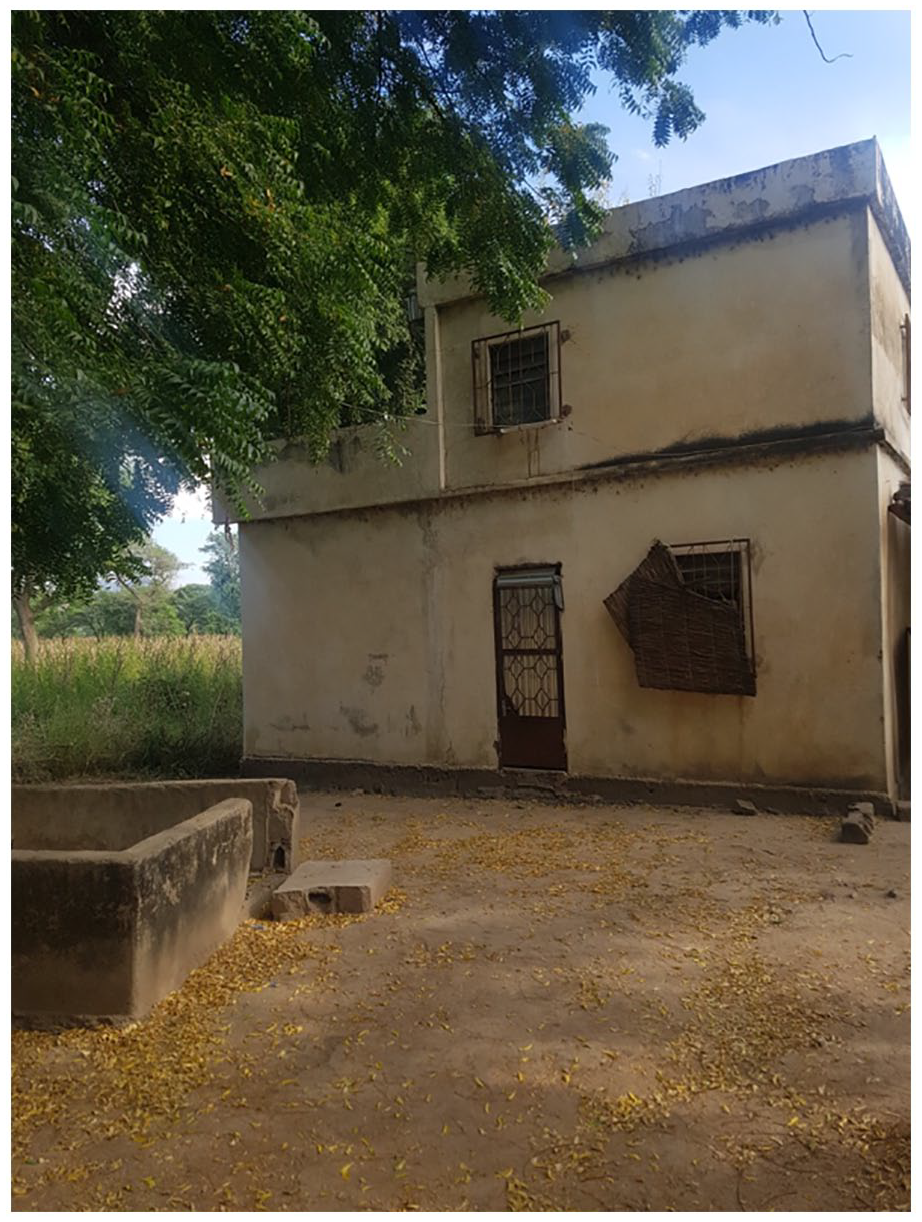
Multi-storey house in Casablanca neighbourhood, Tokombéré (© Author).
Conclusion
This reflexion on the issues of toponymic reappropriation and participation in the public sphere in Tokombéré shows that youth’s political expression is characterized by creativity. The rise of neotoponyms is proving to be a channel for expression of subalterns. Indeed, youth use this means of expression to participate in the local political game. This is a result of local authorities’ closure of political space. Nevertheless, it is noted that this form of political participation, which involves questioning the decisions of a local authority that does not usually deal with them, is only a subtle and sometimes even poaching form (Abé, 2011: 141) of challenging politics. The consequence is that there is an alternative mutation of place names in the city in accordance with the realities of lived experience of Tokombéré’s youth categories. However, this mutation induces authorship rights of these new toponyms, which is most often attributed to no one. The anonymous nature of this phenomenon makes it difficult to confirm the effectiveness of this form of political expression. Consequently, this tendency to call out politicians through unconventional and popular channels rise critical methodological issues, but nevertheless allows for a change in the study perspective of social cadets’ political participation in Cameroon. This leads to a renewed interest in the ‘invention of the everyday and the arts of living’.
Footnotes
Acknowledgements
The author is grateful to Vincent J. Kamga and Jeelin G. Baskouda, respectively, for the English translation proofreading and the editorial work. He is also indebted to anonymous reviewers and editors of the Journal of Asian and African Studies for their insightful comments on the initial manuscript. An early version was presented in 2016 at 4th Rencontres des Études Africaines en France – REAF: ‘Afriques cosmopolitiques’ organized by CESSMA – D&S – LLACAN – PRODIG – URMIS.
Funding
The author received no financial support for the research, authorship and/or publication of this article.