
Abstract
Political scientists and policy-makers have long argued that state weakness leads to civil conflict while enhancing state power helps prevent violence. Why, then, has increased state capacity worldwide recently coincided with more civil conflicts? This study argues that enhanced state presence at the sub-national level—a symptom of growing state capacity—may induce violent resistance from the established non-state powers such as local leaders and communities in the short term. Empirically, I conduct two analyses, one at the province level and the other at the ethnic group level. To measure state presence, I use accuracy of census data in the first analysis and global ground transportation data in the second analysis. Results demonstrate that increased state presence triggers civil conflict, particularly in the first five years of such increasing state presence, and this effect is stronger in remote and ethnically heterogeneous regions. Evidence also suggests that ethnic groups settled in peripheral regions are prominent resisters to state penetration. This paper thus expands prior understanding of the role of state power in civil conflicts.
International relations scholars have long argued that state weakness is a determinant of political violence (Atzili 2010; Fearon and Laitin 2003; Jones 2008; Kaldor 2013; Maitre 2009; Reinold 2011; Rotberg 2002; Tonwe and Eke 2013). According to this account, territory not governed by the state shelters rebel organizations. Further, inability to fend off insurgents leaves the state no alternative but to bear the turmoil. This dominant theory has largely motivated the United Nations to focus on building state capacity in combating violence (UN 2006). The fact that over the past three decades the average taxes to GDP ratio has increased a whole percentage point (from 13.9% to 15.1%) indicates that the overall state capacity has grown globally. 1 Why then did the number of insurgent incidents per year triple (from around 1,500 to around 5,000) over the same period? 2 Why does the increasing state capacity seem not to bring peace as expected?
This paper offers one potential explanation by disentangling the relationship between state power projection and civil conflict at the sub-national level. 3 While most previous literature studies state capacity at the country level, state presence—also termed as state penetration or state reach—is in essence a spatial phenomenon. States do not govern each local area equally well at any given time (Boone 2012; Koren and Sarbahi 2018; Lee 2018; Steinberg 2018). I argue that the overall increasing state capacity enables and incentivizes the state to govern the previously ungoverned or poorly governed regions. Such enhanced state presence often provokes the local non-state powers and can trigger civil conflict in the short term. The effect is particularly likely in peripheral regions where residents are concentrated disadvantaged ethnic groups. This unintended consequence of state presence may account for the higher levels of violence taking place in these regions.
These arguments speak to a larger debate on the global trend of armed conflict and the role that state capacity plays in it (Gohdes and Price 2013; Lacina and Gleditsch 2013; Pinker 2011; Sarkees, Wayman, and Singer 2003; Scott 2010). Noticing that ungoverned spaces have started to disappear as state capacity grows after World War II, Scott (2010) raises a caveat that clashes may occur between the peasant communities and the intrusive state. While the views represented by Pinker (2011) may be right that increasing state capacity decreases violence over hundreds of years, the current paper, aligning with Scott (2010), indicates that short-term expansion of state presence does indeed come with a backlash.
I conduct two sets of analyses to demonstrate the proposed effect of state presence. The first analysis is at the first-level administrative units, e.g. provinces. Following Lee and Zhang (2016), I use the accuracy of census data as a proxy for state presence, which covers seventy-four countries across twenty-five years. The periodic nature of census allows me to calculate the change of state presence over time. The civil conflicts concerned here are those that fall within each province in the years subsequent to the census. The second analysis is at the ethnic group level. I collect global ground transportation data (road and railroad) and overlay it with the settlement patterns of politically relevant ethnic groups with Geographical Information System (GIS). This constitutes a measure of state presence in relation to individual ethnic groups. Multiple data sources 4 identify the conflict incidents for which each ethnic group claims responsibility.
I find that a large rise in state presence increases civil conflicts in succeeding years. This violence-inducing effect is moderated by two conditions: distance to the capital and the presence of geographically concentrated ethnic minorities. State presence is more likely to trigger violence in distant regions and in those with different disadvantaged ethnic identities. This pattern is consistent with the theory relying on the resistance from non-state actors because the two moderators often favor the formation of a local authority prior to the state’s arrival. Results from the second analysis further substantiate this explanation. Among ethnic groups not fully incorporated into the state systems, those reached by the state are more likely to revolt than their isolated counterparts.
This study provides insights into understanding the puzzling and complex relationships between state capacity and civil conflict. The sub-national level analyses challenge the conventional wisdom that extending statehood reduces violent incidents (Pinker 2011) and show that it could have the opposite effect. The paper thus deepens our understanding of the state’s role in civil conflicts. It implies that state building practice should put more weight on negotiations with established local non-state authorities to prevent fierce resistance. However, Scott (2010)’s argument that groups in peripheral areas often settled there to escape the state’s reach suggests this will be hard.
State Weakness and Civil Conflict
Two concepts are crucial in understanding state power: (1) state capacity, i.e. the overall power of a nation-state to administrate its territory (Evans, Rueschemeyer, and Skocpol 1985), and (2) state presence, i.e. the allocation of state power at the sub-national level. The lower the state capacity, the more likely is state presence to be insufficient and uneven across regions. Existing literature terms this phenomenon as limited statehood (Risse 2011) or incomplete sovereignty/inefficient governance (Lee 2018). At the national level, much evidence shows that countries with low capacity are more likely to experience civil conflict (e.g. Fearon and Laitin 2003). Since these weak states generally leave a portion of their land ungoverned, scholars then infer that the regions with less state presence are to blame for those conflicts. Two possible mechanisms have been proposed for this effect.
First, stateless areas could become ideal shelters for insurgents (Fearon and Laitin 2003; Gleditsch, Salehyan, and Schultz 2008; Hironaka 2009; Jones and Johnston 2013; O’Donnell 1993; Tollefsen and Buhaug 2015). The anarchical environment breeds violent groups with the ambition of ruling over the region and, potentially, challenging the state (Jones 2008). Under little surveillance from the central government, those groups have the time to construct their base, strengthen their organizations, and practice guerrilla warfare (De La Calle and Sánchez-Cuenca 2012). As the rebel groups emerge and grow, they gradually take over the stateless territory and become the de facto rulers of the regions (De La Calle and Sánchez-Cuenca 2012). The central government is not able to enter the rebel-controlled regions without enough administrative information and necessary transportation. It is then placed in a passive position. Even in the circumstances where the state managed to send boots on the ground, its troops typically have a hard time fighting against the militia’s forces in such areas (Buhaug 2006). Violent incidents take place consecutively because the state cannot evict the rebels.
Second, mobilization is relatively easy in regions absent of state authority. Because the state is unable to provide basic services and social order, rebels do this instead (Jones 2008). While doing so, they define constituencies and broadcast their ideas and values among the community. This helps them to win public approval and political support. Furthermore, recruiting combatants is inexpensive because economy in these regions is normally underdeveloped (Bueno de Mesquita 2005; Fearon and Laitin 2003). In many cases, individuals do not have many opportunities to make a living apart from joining the militia. Mobilization is then attractive to a wide range of socioeconomic classes, not only to the worst-off people (Bueno de Mesquita 2005). As a result, violent groups maintain an abundant source of recruits and keep themselves alive despite violent conflicts and casualties.
While plausible, empirical evidence for the connection between state weakness and civil conflict is surprisingly weak at the sub-national level (Koren and Sarbahi 2018). Stateless regions do not immediately incubate violence. Wherever state authority is missing, communities there seek for a different social order to provide security for themselves (Menkhaus 2007). Typically, such an order is organized around local leaders. Although these leaders might have military backgrounds, they do not only recruit people to the guerrilla life, but, instead, provide public goods, which phenomenon is widely known as “rebel governance.” They claim responsibility for their people—such as those of a certain ethnic group—just like the elected officials. These “governors” need to continue offering infrastructure, administration, education and healthcare to satisfy their “constituencies” (Mampilly 2012), and even to justify their legitimacy as an independent state for the future (Stewart 2018). In Puntland of Somalia, for example, the regional government founded by clan leaders and elders is more functional than the central government (Menkhaus 2007). Similarly, dozos 5 in Cote d’Ivoire routinely perform state-like functions such as policing (Blair and Kalmanovitz 2016). Contrary to expectations in the literature, then, regional non-state authorities do not fight endlessly in the absence of the state.
From State Capacity to Civil Conflict
Rather than absence of the state, I argue that it is the penetration of state power in local contexts that is likely to provoke regional non-state authorities who may react violently when their power is threatened. While state penetration is expected to bring more counter-insurgency effectiveness, I uncover evidence that its backlash effect is more prominent. This result is in line with Cohen, Brown and Organski (1981)’s theory that violence is an integral part of state making and Tilly (1985)’s argument that state making itself is organized crime. In the same vein, a recent study shows that civil wars often erupt in the regions with the presence—not absence—of states (Koren and Sarbahi 2018). Building upon their work, I look beyond civil wars and examine all conflict incidents with battle deaths. This picks up, for example, dozens of armed conflicts between the government of Mozambique and the rebel RENAMO 6 in the 2010s, whereas studies that only examine civil wars would suggest the Rome General Peace Accords ended the war in 1992. Thus, while Koren and Sarbahi (2018)’s study focuses on 117 civil war onsets, the current study inspects the motivations behind more than 10,000 low intensity state-based conflict events. I theorize that increased state presence in previously ungoverned or poorly governed regions is likely to trigger civil conflict more generally. In what follows, I will specify my argument in more detail.
State Capacity Restricts State Presence
Most countries do not spread power and authority evenly over their territories (Boone 2012; Koren and Sarbahi 2018; Lee 2018; Steinberg 2018). This is especially the case for the state with low capacity, which is unable to broadcast goods and personnel. The limited resources force the state to prioritize some regions over others. Typically, the government first chooses the central area close to the capital due to the low cost of management. It invests in infrastructure and administration there but leaves other spaces with insufficient governance. A good illustration of this is the popular statement in Central African Republic: “The state stops at PK 12 [12 kilometers from the capital, Bangui, C.A.R.].” (Bierschenk and Olivier de Sardan 1997) Peripheral regions then become a vacuum of state power even though they are within the internationally recognized state border.
While the state is absent, most of these peripheral regions are inhabited by indigenous people, who have over time formed their own social order (Blair and Kalmanovitz 2016). These communities have developed economic self-sustainability and self-sufficiency. Politically, they adhere to their local leaders. In Africa, for example, numerous regions historically controlled by chiefs still possess their autonomy (Herbst 2000). Peripheral regions with difficult terrains, in particular, have long incubated a variety of local communities, which are often divided along ethnic lines (Carter, Shaver, and Wright 2019; Scott 2010). Due to the geographical barriers, these ethnic groups are segregated from each other and separated from the state (Fearon and Laitin 2003; Hendrix 2011; Tollefsen and Buhaug 2015). Even though they are supposed to be part of the nation, they are reluctant to join the national system. Zomia, the vast Southeastern Asian highlands, illustrates this point. 7 Until the most recent decade, “about one hundred million minority people […have] not yet been fully incorporated into nation-states” (Scott 2010, ix).
The existence of established non-state powers makes it harder for the state with limited capacity to enter these regions relative to regions without indigenous residents. The central government often regard the local rulers as potential (ethnic) rivals (Thies 2007). It is aware that accessing their lands might lead to confrontations and conflicts (Lemke 2011; Tollefsen and Buhaug 2015) and even just building a road connecting these places could increase such risks (Herbst 2000). For that reason, many states simply delegate the governing right to these local non-state powers (Cammett and MacLean 2014; Risse 2011; Steinberg 2016). This is beneficial to both sides as violent conflict is avoided. It further helps the central government to save resources and the customary authorities to retain their power. For example, the escalation of “strongman” governance in several important Afghan provinces has been acquiesced by the Karzai regime in the early 2000s (Mukhopadhyay 2014). Similarly, Somalia left the Puntland region almost completely to ethnic leaders in 1998 (Blair and Kalmanovitz 2016).
In sum, the distribution of state power is not random. The level of state presence in each region reflects the central government’s strategic choice. If a state’s overall capacity is limited, it is likely to intentionally avoid the distant regions and those occupied by established local non-state powers because the cost of consolidating these people and territories outweighs the potential benefit. Further, under current border paradigms (e.g. Atzili 2012), neglecting or avoiding outlying areas yields low risk for governments.
Spreading State Presence Encounters Resistance
As a state’s capacity increases, it changes its benefit-cost calculation and becomes more incentivized to consolidate the previously ungoverned or poorly governed regions. A stronger economy makes it more affordable to send off roads, utilities, bureaucracies and police forces to peripheral regions. A higher counter-insurgent ability also makes potential conflicts less intimidating. Compared with these reduced costs, the benefits of extracting local resources become notable (Thies 2007). States choose to go to certain regions primarily based on the potential land revenue there (Callen et al. n.d.)—the revenue from collecting tax, occupying lands, and exploiting natural resources (Rasler and Thompson 1989; Tilly 1992). The additional assets could further boost the economy and add to patronage goods. Besides, controlling remote areas is equivalent to extending the defense frontier. These areas are vulnerable to foreign interventions. States’ investment there would make it a buffer for external threats, ensuring security in the core regions (Herbst 2000). Thus, when its capacity allows, a state starts exerting power in remote areas—a ubiquitous phenomenon after the Second World War (Scott 2010). While providing necessary public services, the state often takes its ownership of the local resources for granted because these regions are its uncontested territory.
However, the local communities may not immediately accept the state control because they enjoy high homeland legitimacy (Toft 2002). They are used to complying with their customary authorities and regarding the state as an outsider. Despite the possibility that they would benefit from more public goods from the state in the long run, they often first regard its arrival as the pillage of their assets (Gavrilis 2008; Steinberg 2016). Similarly, the local leaders are likely to be infuriated by the coming of the state. They seldom challenged the central government in the past because it used to admit their dominion (Cederman et al. 2015). Now the state wants to take over their ruling power, resulting in frictions. At this point, fair deals about power-sharing are often easier to say than do because once the state moves in it almost always has the relative power to renege. This is a noticeable pattern, for instance, in negotiations between the U.S. government and Native Americans in the 1800s, where the state’s increasing power produced harsher treaties on the native tribes, which were all subsequently broken (Spirling 2012).
Compared with giving in to the state and betting on the future gains, violent resistance becomes a more conceivable option for the local non-state powers (Koren and Sarbahi 2018). One advantage of these local authorities is that they have an easier time gathering support from local communities by portraying the state as their common enemy. Consider, for example, the case of Colombia. The state building process there was accompanied by continuous land grabs. Such extraction facilitated the mobilization of FARC 8 and EPL 9 (Grajales 2013), and large-scale insurgencies have pestered Colombia for decades. Likewise, the Papua New Guinea government in the 1980s kept sending workforce to Bougainville, a peripheral region, for copper mining. The loss of copper resources inflamed the local communities. The BRA 10 took advantage of the collective resentment and instigated an armed struggle against the government in 1989 (Thompson 1991).
In short, a state extends its presence when its capacity grows. Within each state, such an increase of control in peripheral regions often encounters resistance from established local non-state powers, leading to civil conflict. The preceding logic leads to my first hypothesis, which focuses on within-country variation:
Two Conditions: Remoteness and Ethnic Diversity
For the central government, the purpose of consolidating its peripheral territory is mainly resource and security, while conflict incidents are unintended consequences that would only occur when local non-state powers resist. This implies that the pre-existence of non-state actors in local contexts and their ability to initiate conflict is vital to the provocation effect of increased state presence. It is then worth asking: in which types of regions are these powers likely to be more established and stronger?
First, we must consider remote areas, i.e. areas far away from the capital. Being close to the state capital means “easy-to-reach” by the central state power. In contrast, remoteness gives non-state actors a chance to fortify their strongholds and maintain their rule (Tollefsen and Buhaug 2015). In actuality, the local authorities often remain in power even when the central government collapses because they are too far away to be affected (Scott 2010). The continuous dominance of the non-state actors justifies their legitimacy among the local communities. From these communities’ perspective, their local leaders are visible and reliable but the state government is not because the former interact more with them in their daily life. Therefore, local leaders are more likely to exert influence and develop into an established and strong force in a region further from the capital. The central-peripheral continuum is then expected to condition the effect of enhanced state presence on civil conflict:
Second, regional powers are more likely to be stronger in areas settled by disadvantaged ethnic minorities because these groups are more likely to establish their own authority. Co-ethnics often live concentratedly in their own space (Balcells, Daniels, and Escribà-Folch 2016; Carter, Shaver, and Wright 2019; Cederman, Gleditsch, and Buhaug 2013). This geographic proximity facilitates the construction of a unique social order and mobilization for collective actions. The separate, socially constructed identity could yield an ethnic minority that feels disjointed from the state, particularly in cases where the group is politically excluded from the central government (Cederman, Gleditsch, and Buhaug 2013; Denny and Walter 2014; Smith 2000). Where the state leads the charge in identifying and classifying individuals into specific groups, which phenomenon itself is a sign of enhancing state presence, cohesion among the group and resistance to the state’s claims may be high. In extreme cases, the dominant group, being the state authority, even depreciates the out-group identities and deny their existence, as was the case for Turkey toward the Kurdish (Marcus 2009). When this discrimination occurs, at least a confined local population are likely to adhere to their ethnic leaders’ claims (e.g. the Kurdish as a separate ethnic group), as opposed to the state’s (e.g. the Turkish as a unified ethnic group), and fight violently for their identity (Tezcür 2016). Taking these nuances of ethnic minority group formation and state messages into account, we are expecting this complexity to have an impact on the relationship between enhanced state presence and civil conflict.
The ethnic minorities of interest here are those of great enough size and political clout to have relevance to a country’s political processes. This definition does not include very small groups that are not large enough to challenge the state. For example, in Vietnam ethnographers identify thirty one groups in the North (Michaud, Turner, and Roche 2002), while Wucherpfennig et al. (2011) only identify seven politically relevant groups.
Research Design
Empirically, two sets of analyses are employed to disentangle the relationship between state presence and civil conflict at the sub-national level. I begin my analysis with the first level administration units, e.g. provinces, to directly assess the three hypotheses. Then, I conduct another analysis at the ethnic group level to draw further evidence of the resistance from established local non-state powers.
A primary challenge of this study is to measure state presence at the two proposed levels. The measures should, aggregately, be consistent with the country-level indicators of state capacity but also reflect the variation of state power projection within countries. Koren and Sarbahi (2018) have proposed using night-time light emission. Their paper, however, is data-driven and concludes with several possible explanations for the association between capacity and war. Their measure cannot adjudicate between different explanations because it is unclear whether the light utility is provided by states or by local authorities. In Kurdish Iraq, for example, oil companies have largely raised the local night-time light level, but this autonomous region is barely controlled by the state government. In contrast, to test the hypotheses presented here, data must offer insights into the clashes between the two forces.
Instead, I use the accuracy of census data collected by Lee and Zhang (2016) as a proxy for state presence in the first analysis. Censuses conducted by the states reflect their efforts to grasp local information. The more a state engages with a region, the more accurate information it has about the local population. Such accuracy is suggested by the “smoothness” of the age distribution curve and captured by an indicator called the Myers Index, which is available for each province across seventy-four countries. Most of these countries conduct censuses regularly, which allows for observation of how state presence has been enhanced (or diminished, in a few cases) over time. I can then evaluate the impact of increased state presence as argued by my theory.
The accuracy of census data is not available at the ethnic group level. Therefore, for the second analysis, I develop an original measure of state presence engaged with ethnic groups using ground transportation data (road and railroad). With GIS, I map all politically relevant ethnic groups around the world that settle in peripheral regions. For each of these groups, I quantify the extent to which it is connected to the central regions via ground transportation. These transportation connections mainly reflect the states’ endeavors to consolidate peripheral regions because regional authorities seldom have incentives to seek out the central government’s involvement (Blair and Kalmanovitz 2016; Scott 2010). Such connections are also what the night-time light emission measure cannot capture.
Province Level: Data and Methods
The dependent variable, Civil Conflict, concerns conflict incidents between a state government and a non-state actor that take place in local contexts and result in at least one direct death. Fine-grained geo-located data of all these incidents since 1989 are drawn from the Uppsala Conflict Data Program (UCDP). For each province-year observation, I count the number of incidents falling within the province border in the five-year period after the concerned year. 11 Such procedures allow for correct time sequencing of variables. I also keep track of the casualties from these conflicts, which reflect the intensity of the incidents. Casualties from the two sides are recorded separately as State Side Casualty and Local Side Casualty, summing to Total Casualty.
The explanatory construct, increased state presence, is calculated from the Myers Index, which indicates the accuracy of age data from national population censuses. The true age distribution in any society should, theoretically, follow a smooth curve. In regions where the state has little interaction with the population, a large number of people do not register their ages for administrative purposes. For this reason, many of them cannot recall their true age and simply guess when asked to report their age as part of a census. Demographers have long noted that those guesses are more likely to terminate with even numbers or the digits “5” and “0.” If this is the case, the collected age distribution would “heap” on these numbers. Myers Index quantifies the extent to which an age distribution deviates from a smooth curve. Lee and Zhang (2016) introduced the Myers Index to political science and showed that this variable reflects the spatial variation in state authority. 12 A larger value on the index means a less accurate census and, therefore, less state authority.
Since states initially allocate different amounts of power in different regions and my hypotheses are about the increase in state presence, I do the following calculation. I subtract the value associated with the current province-year observation from that with the last available year in the same province. This indicates how much Myers Index has been reduced over years. Since countries do not conduct censuses at the same frequency, I scale this difference by the time span. The resulting number reflects the Increase in Census Accuracy and is notated below, where i refers to the last available year and j refers to the current year. 13

The Myers Index has been proven to be an unbiased estimator of state presence (Lee and Zhang 2016). Even when the interviewers shirk a portion of the population, they are as likely to miss a person whose true age terminates at one of the heaped values (such as 20, or 55) as to miss someone whose age terminates at a non-heaped value (such as 29, or 53). In extreme circumstances where wars and conflicts prevent bureaucracies from entering a region and conducting a census, there would be missing data. However, the vast majority of the countries examined here have reported census data for all of their regions. 14 Since the theory identifies within-country variation rather than across-country variation, the exclusion of some countries from the analysis is not really problematic.
The empirical model contains several province level covariates. As is earlier discussed in the theory section, remoteness and ethnic groups condition the relationship between increased state presence and civil conflict. Distance to Capital is the distance from the centroid of the province to the state capital. Disadvantaged Ethnic Minorities is a count of different geographically concentrated ethnic groups that are discriminated, powerless, self-excluded, or (participating politics as) junior partners during the years concerned, as opposed to their advantaged counterparts that are (participating politics as) senior partners, dominant, or monopolistic. These statuses are obtained from the Geo-referencing Ethnic Power Relations (GeoEPR) Database. 15 Although the definition of “ethnicity” varies across countries and time, this data source allows me to focus on the fact that some socially constructed groups hold disadvantaged positions compared with the state. Even in cases where the state has intentionally or unintentionally helped forming ethnic identities, some of these identities, together with their publicly known disadvantaged positions, have been able to provide individuals a feeling of attachment to their co-ethnics—a necessary condition for mobilization. To address the endogeneity concern that a central government might go to a region because of the ongoing conflict there, I control for Prior Conflict Incident. Like the dependent variable, it is also measured in a five-year window but before the explanatory variable (before year i in the above notation). The Global Terrorism Database (GTD) provides geo-located violence data in a much longer time span than UCDP, and thus I use the former source here to preserve the number of observations and the latter in the Online Appendix. Another attempt to address the selection effect of states’ decision in going to certain places is to control for agricultural suitability. Fertile lands are more attractive to the state than their barren counterparts because they are better at feeding a population and generating revenues (Callen et al., n.d.). Specifically, I take into account the suitability for Dry Rice, Wet Rice, and Wheat using the data from Food and Agriculture Organization of the United Nations (UNFAO). While studying civil conflict, it is often necessary to consider the influence of foreign powers. I control for Militarized Interstate Dispute from the Correlates of War Project to examine an alternative explanation that domestic conflict is motived to fend off foreign rivals. 16 In addition, Province Area is controlled for. The larger the area, the larger the baseline probability that it would capture a conflict incident. Simultaneously, province area varies substantially across observations and such variations largely reflect the potential value of different regions to the state, affecting state presence. Finally, to condition out a systematic time trend of conflict due to, for example, reporting bias, I include the Year variable in the regression.
State presence at each region is largely confined by the overall state capacity. That is, a more capable state would have more resources to distribute. The within-country variation is thus crucial in understanding the pattern of civil conflicts. In this analysis, I introduce country fixed effects in all models to partial out all country-level confounders. The next section demonstrates the results from ordinary least squares (OLS) models with log-linear transformations of the dependent variables. Other model specifications including count models, are presented in the Online Appendix, along with a series robustness checks for the province level analysis. 17
Province Level: Results
The first model in Table 1 shows that increased state presence (indicated by Increase in Census Accuracy) positively correlates with Civil Conflict. When a state enhances its authority in a region within a short period, the region is more likely to revolt and fight against the central government. Transfer of power from local non-state leaders to the state often concurs with confrontations and clashes. On average, one unit increase in census accuracy is associated with an increase of civil conflict incidents by
The Effect of State Presence on Civil Conflict (OLS Models).
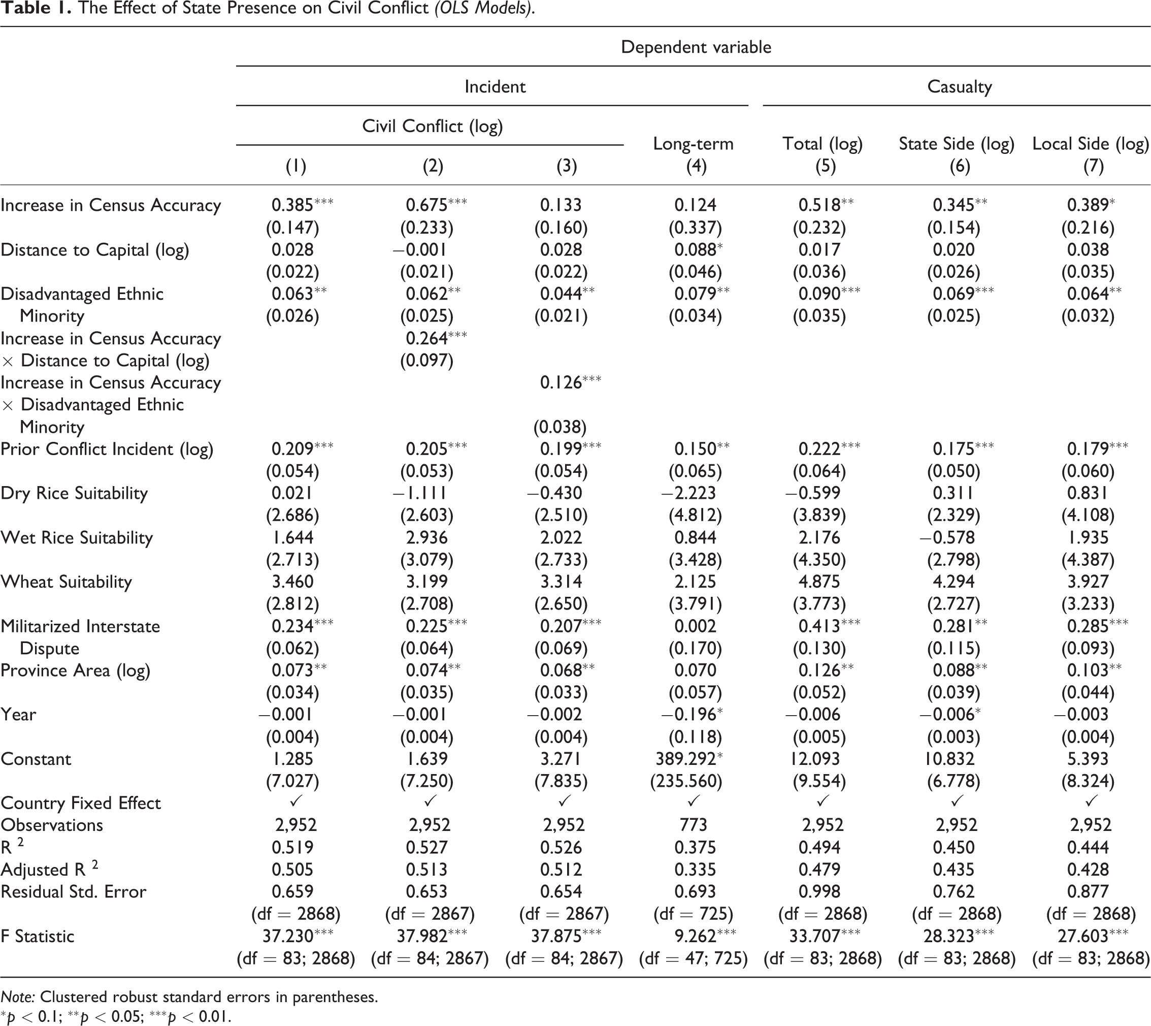
Note: Clustered robust standard errors in parentheses.
One might argue that we observe more conflict incidents with increased state presence because violent groups could no longer carry out large-scale attacks under more surveillance and they have resorted to multiple low-intensity ones. To rule out this possibility, I further look at casualties from these conflicts, as shown by models (5) to (7). Results demonstrate that casualties from both the state side and the local side are positively correlated with increased state presence. With more state forces, the local non-state powers, or rebels, could actually cause more deaths from the government. Simultaneously, they pay a higher cost as they also sacrifice more combatants. This latter pattern partly suggests that these violent groups are more resolved to fight when the threat to their power from the state has largely increased.
It is worth noting that the provocation effect is salient here only in the short term as the dependent variables are measured immediately after the explanatory variable. In model (4), the dependent variable is measured as conflict incidents twenty years after the increase in state presence and the significance no longer holds for this “long-term” construct. Such a contrast is consistent with my expectations because conflict may end once the state subdues the local leaders. Moreover, local communities may gradually accept the state’s rule as they start enjoying the public benefits provided by the latter.
To test the two conditional effects of remoteness and ethnicity presence conjectured in Hypotheses 2 and 3, I interact these two moderators with the explanatory variable in models (2) and (3). Unsurprisingly, both interaction terms are positive and significant, suggesting that heterogeneity exists among provinces. The resistance theory is more applicable to more remote areas and areas with ethnic groups.
Being aware that two assumptions underlying models (2) and (3)—linear interaction effect and sufficient common support—might be violated, I further use kernel smoothing estimators to assess the interactions, as is suggested by Hainmueller, Mummolo, and Xu (2019). Figure 1 visualizes the marginal effects of enhanced state presence from these semi-parametric models, where the same covariates as the linear models and country fixed effects are included. The left panel shows that increased state presence induces opposite effects in central regions and in peripheral regions. In areas close to the capital, such practice indeed promotes peace, as conventional wisdom would expect. In regions further from the capital, however, enhancing state authority is likely to provoke conflicts. The right panel indicates that the existence of disadvantaged ethnic minorities magnifies the “conflict-inducing” effect. The marginal effect becomes significant with two or more such groups. This effect slightly gets stronger as the number of ethnic minorities increases because a higher level of ethnic diversity means more local leaders and communities that could potentially resist state penetration. In other words, it indicates a higher baseline probability of conflicts between the state government and a non-state actor, without any assumptions about the interplay among different non-state actors.
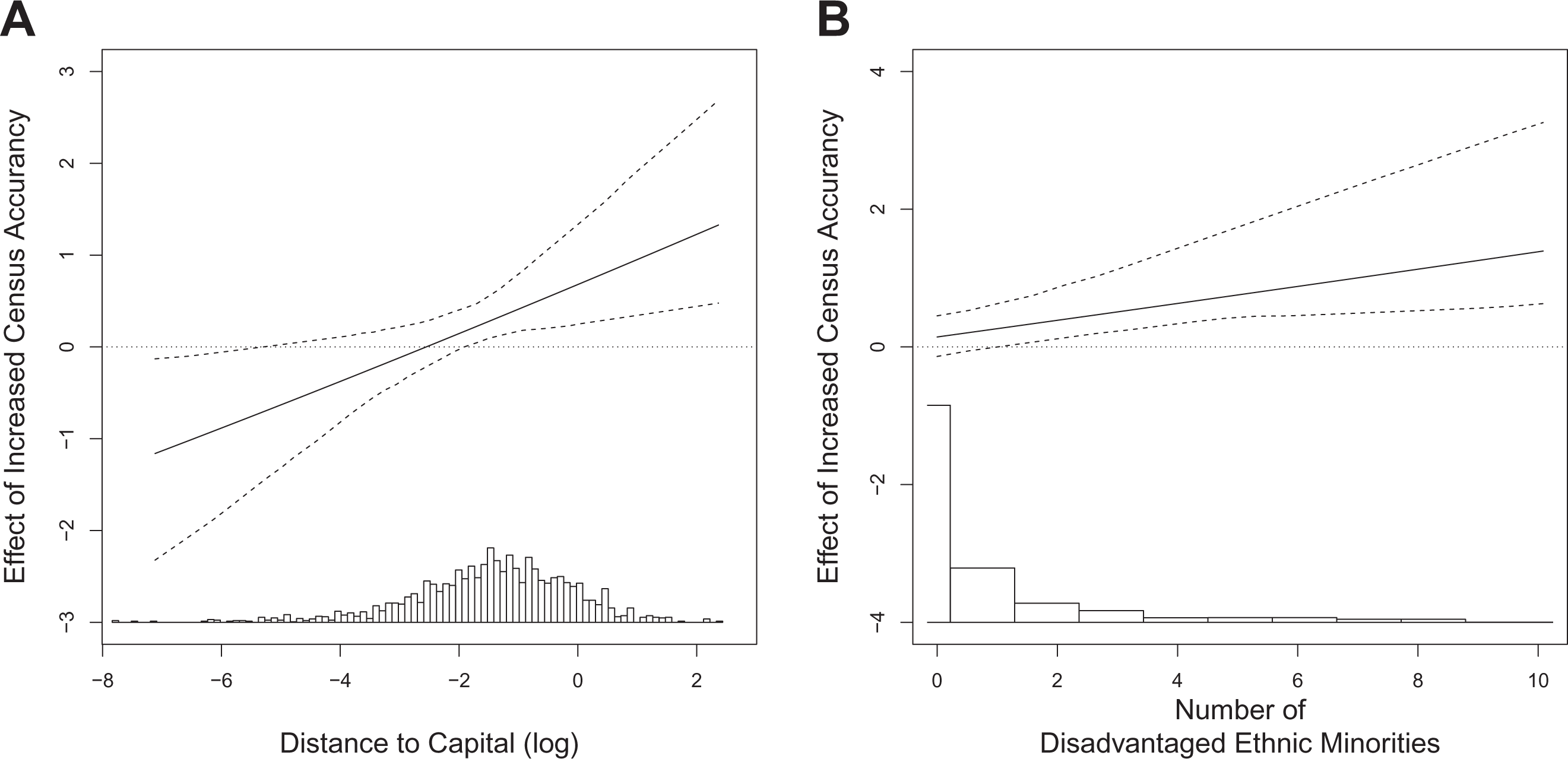
Marginal Effects of Enhanced State Presence Using Kernel Estimators. (A) Conditional on Distance to Capital. (B) Conditional on Disadvantaged Ethnic Minority. Note: The 95% confidence intervals are shown. They are obtained from a non-parametric bootstrap procedure clustering on countries.
In all six models in Table 1 (except model (4)), Prior Conflict Incident, unsurprisingly, is positively correlated with both conflict incidents and casualties. Places bearing conflicts in the past are likely to do so in the future. Similarly, Militarized Interstate Dispute yields a positive effect, indicating that foreign intervention might exacerbate domestic conflict. The point I make here is that enhancing state presence triggers conflicts even after controlling these two other violence-related variables. Province Area is also significant. The larger the province, the more likely a conflict is going to fall within its boundary. The Disadvantaged Ethnic Minorities is overall positively correlated with Civil conflict. That suggests separate minority identities potentially bring friction. The baseline probability of observing civil conflicts in ethnically heterogeneous societies is high. Distance to Capital is not significant in these models. While conventional wisdom argues that remote regions shelter rebels, the current result does not suggest that these regions are necessarily the cradles of violence. As I discussed first in the theory section, the states often avoid the distant regions in the first place. Although Agricultural Suitability may motivate states to control certain places, it does not seem to directly induce violence.
Ethnic Group Level: Data and Methods
The province level analysis so far has provided evidence for all three hypotheses. It, however, has not been able to show that it is the local non-state powers that are responsible for these conflicts. To remedy that, I am going to identify the potential resisters and see how state presence affects their chance of fighting the government. Ideally, I would like to show that these non-state powers employ more violence after an increase of state presence. Unfortunately, I am unable to measure the change of state presence in relation to any one regional-based group over time. What I do here is take a snapshot in time, gauging the state-local connections for each group and comparing the volume of violence different groups committed later. If results show that local non-state powers that are connected more with the states are more hostile to them, then I would be more confident that a typical group would be more likely to revolt when state presence increases.
The observational units for this analysis are politically relevant ethnic groups around the world as they are the most common type of established non-state powers. The GeoEPR database has made available their geo-coded settlement patterns (Wucherpfennig et al. 2011) and I focus on those in 2012. 18
The dependent variable, Civil Conflict, is still from UCDP. Different from the province level analysis, here I only attribute a conflict to an ethnic group if the armed force confronting the government has either claimed for or recruited members from that ethnic group. The “ACD2EPR” transformation table from EPR provides information of these claims and recruitments. This approach follows the existing studies on ethnic conflict (Cederman, Gleditsch, and Buhaug 2013; Vogt 2018). To be consistent with the first analysis, civil conflicts considered here also span five years (2012–2016). Overall, about 8.37 percent of ethnic groups in the sample are involved in conflicts. Again, I aggregate the Casualties across incidents for each observation.
Apparently, not all ethnic groups are local powers. To identify the potential resisters to state penetration, I first exclude the monopolistic ethnicities whose settlement patterns contain the state capitals, such as Chinese (Han) in China and Hungarians in Hungary. The remaining groups are still not all regionally based powers. Some of them have a voice in the central government by, for example, electing representatives to the parliament. In that sense, they are part of the state and seldom confront the state. To account for this fact, I use zero-inflated models empirically. In the first stage, Political Exclusion from the Ethnic Power Relations (EPR) Dataset screens out the excess zeros attributed to the groups holding power in the central governments. 19 The remaining zeros then truly reflect that the local ethnic power did not commit violence.
In the second stage, I model the count with the following variables. The explanatory variable, Transportation Connection, is a proxy for state presence specifically collected for this project. I overlay the worldwide major road and railroad data from Natural Earth 20 on the ethnic groups’ settlement patterns with GIS. This practice informed me the extent to which a certain group was tied to its state. Figure 2 gives an example of the ethnic Tiv in Nigeria. I counted the number of the “connection points” and divided the count by the perimeter of the group polygon. The resulting “density” is a proxy for state presence, indicating how easily the government’s personnel and goods can reach an ethnic group. Note that this density of “ties” is different from the density of transportation networks within a community, and it reflects how connected a group is to the state, instead of how prosperous it is. 21 I would like to add that no information is available on when and why roads into and out of these regions have been constructed. At present, data have not been compiled which allow me to partial out the possible reverse causality. Future research with more rigorous identification strategy is still needed.
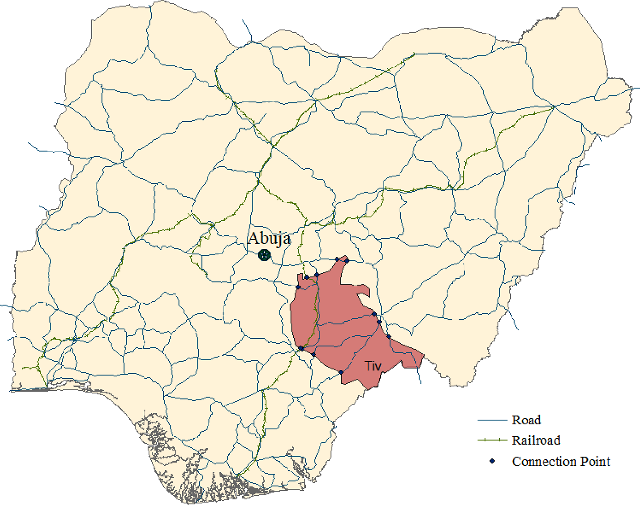
Measuring State Presence Engaged with the Ethnic Tiv (Nigeria) using Transportation Connection. Note: The connection points counted here are those that connecting the Tiv to the other parts of Nigeria (eventually to the capital, Abuja, through the transportation network) but not to other neighboring countries.
Five group level covariates are considered. An ethnicity’s Group Size would largely influence the central government’s decision about consolidating it and also indicate its mobilization capacity once provoked (Cederman, Wimmer, and Min 2010). EPR measures this feature with the group’s population size as a fraction of the ethnically relevant population of this group’s country. Group Area from GeoEPR is the territorial area settled by the group. The larger the area, the more likely the group is connected with the state by ground transportation. Transnational Ethnic Kin is accounted for in the analyses because it has long been found correlated with both the state-group relationship and with political violence (Davis and Moore 1997; Goemans and Schultz 2017; Huth 1998; Siroky and Hale 2017; Woodwell 2004). I code it as 1 if an ethnic group has a relevant transnational kin and 0 otherwise, as is recorded by EPR. Foreign Connection is analogous to state presence. It is also measured with the ethnic groups’ settlement patterns and ground transportation but quantifies the connection between the group and foreign states. Those connections indicate potential foreign interference, which is supposed to weaken state authority and increase the risk of civil conflicts (Lee 2018; Salehyan 2011). Mineral Resources from United States Geological Survey (USGS) indicates the number of metallic and nonmetallic mineral sites on each group’s land. This variable is included to address the concern that natural resources may be a common cause for road building and conflict.
Additionally, I include three country-level covariates. The overall development level of a state determines the total resources that a country could potentially allocate among regions and represents a state’s ability to fend off insurgents. Following the convention of prior conflict studies (e.g. Fearon and Laitin 2003), I include GDP and Infant Mortality from The World Bank. I also control for Regime Type because different regimes adopt different strategies when consolidating their territories. Unlike the provincial analysis, the ethnic group analysis does not require fixed effects and I, thus, primarily fit count (Zero-inflated Negative Binomial) models. Poisson models, OLS models, and Negative Binomial models without the zero-inflation portions are included in the Online Appendix. Results presented below are not model dependent.
Ethnic Group Level: Results
Table 2 shows the results from the two-stage models. In the first stage, the effect of political exclusion is negative and significant in all model specifications as expected, i.e. the more a group is politically excluded, the less likely it yields an excess zero. The data generation process for this part has little to do with the spatial distribution of state power. Thus, state presence, measured by transportation connection, is insignificant.
Ethnic Groups with More State Presence Are More Likely to Engage in Civil Conflicts (ZINB Models).
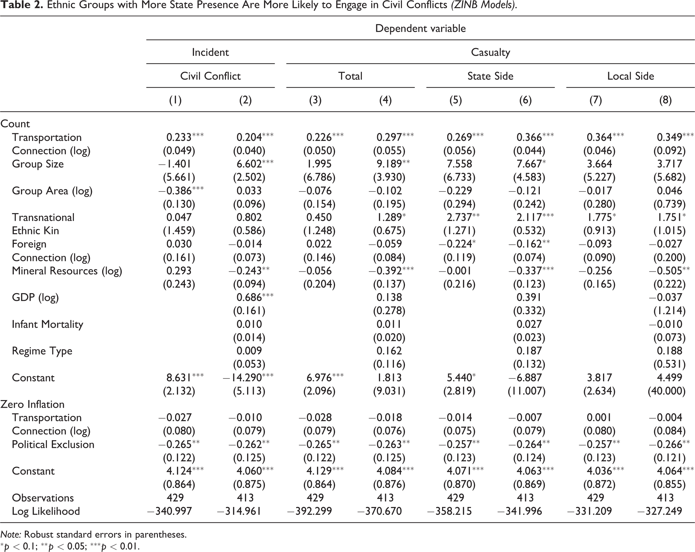
Note: Robust standard errors in parentheses.
The second stage from models (1) and (2) demonstrates that, for ethnic groups prone to be involved in civil conflicts, state presence significantly increases their chance of revolting. This provides direct evidence for the conjecture that ethnic groups as established non-state powers are the prominent resisters. Specifically, for a change of one unit in state presence, the count of civil conflicts is expected to increase by a factor of
To further depict the effect of state presence in an intuitive way, I simulate the predicted count of conflict incidents in Figure 3. When state presence is at the lowest level, only about two conflict incidents occur in a five-year span. With the highest observed level, however, the estimated count is about thirty-two. These two numbers are substantially different, indicating the risk of conflict varies much when state presence is ample and when it is not. 22
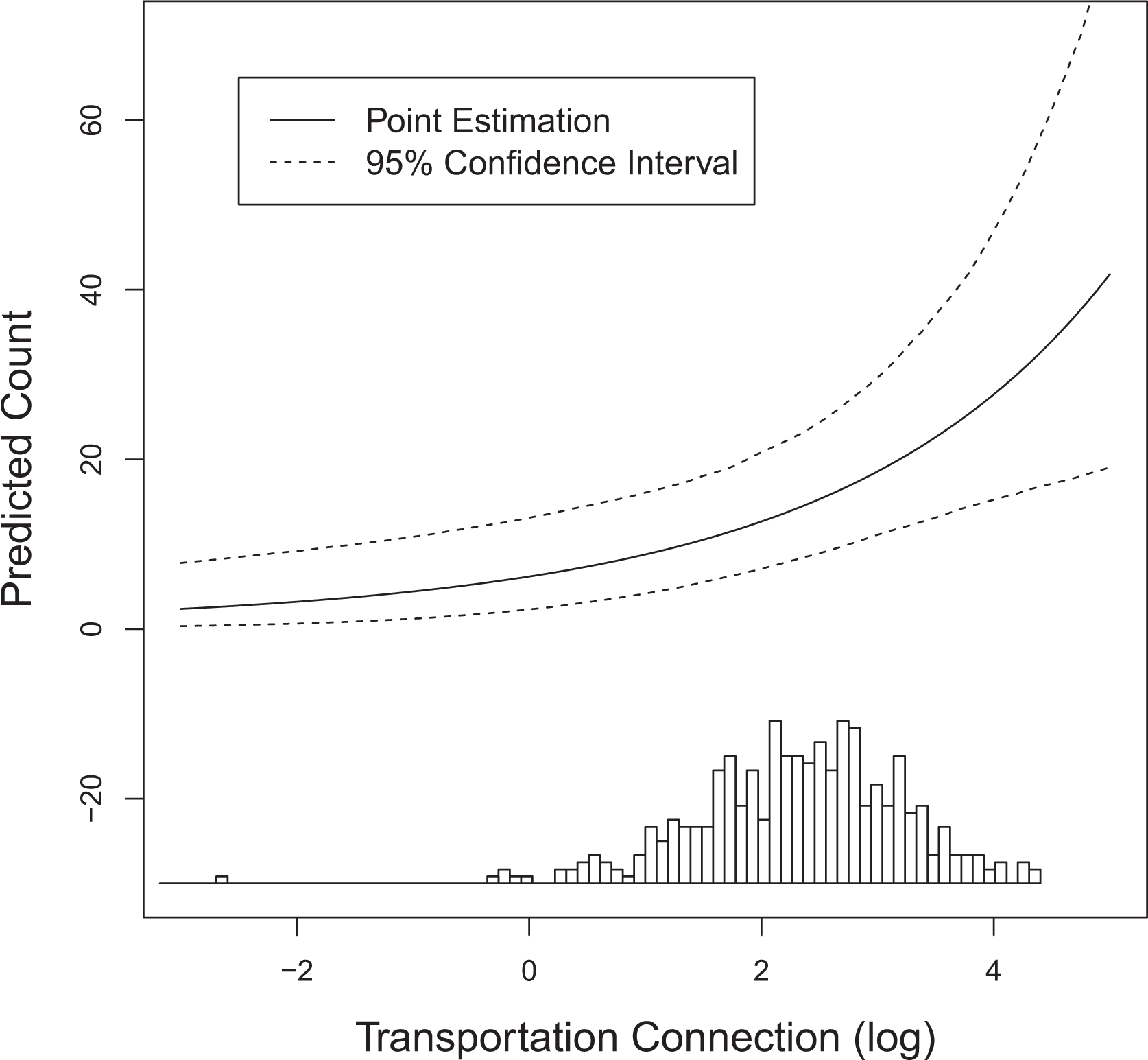
Predicted count of civil conflicts. Note: The 95% confidence interval is obtained from simulations. Model specification is the same with the first column of Table 2. The x axis, Transportation Connection (log), is equally divided into 80 intervals. All covariates are held at their means.
The effects of Group Size and Group Area are inconsistent across different model specifications. In a few cases, Group Size positively contributes to the outbreak and casualties of civil conflicts, while Group Area negatively. These two variables capture two different aspects of the groups. A small group scattering in a large area is hard to be mobilized as a whole. This group is thus less capable of fighting the government. On the contrary, a large group clustered together is more capable of doing so. The two international factors, Transnational Ethnic Kin and Foreign Connection, and the three country-level variables do not explain much about civil conflicts at the sub-national level, nor do Mineral Resources.
Conclusion
This paper provides an explanation for the puzzling relationship between growing state capacity and increasing civil conflicts. I theorize that the burgeoning capacity enables states to expand their authority over previously ungoverned regions and that such expansion may provoke established local non-state powers to use violence. I employ two sets of empirical analyses, both using recently developed measures of state presence at the sub-national level. The results confirm my expectation that enhancing state presence increases the number and intensity of civil conflict incidents, especially in remote areas and areas settled by ethnic groups. This pattern, which is identified off of within-country variation, is different from the conventional wisdom drawn from cross-country comparisons. Evidence also supports the additional implication that ethnic groups in peripheral regions resist state penetration.
These results expand prior understanding of the impact of spreading state authority on political violence. Although scholars generally hold a positive view about expanding state governance, I show that states may break peace while pursuing prosperity. The reason—often ignored by existing literature—is that a relatively large increase of state power could transform local non-state actors into more violent ones. The Indians in Peru’s Amazon forest became aggressive to the outsiders only after the oil industry barged into their region, bringing diseases and massive deaths in their community (Survival 2019). Noticeably, this is not the case for all regions and is only applicable to those with pre-existing non-state powers. Furthermore, evidence only supports the provocation effect in the short term but not for a longer period. I emphasize these conditions here and suggest more attention to the heterogeneity at the sub-national level and across time in conflict studies.
The finding also has multiple policy implications. To avoid conflicts, policy-makers need to put more weights on negotiations with local customary authorities before taking over their powers. This is important because established non-state powers are still prevalent in the contemporary world: tribe leaders in Pakistan, indigenous people in Bolivia, chiefs in many African countries, etc. Sometimes it might be necessary for the central government to make concessions and accommodate the local leaders in the state system given their homeland legitimacy.
The conflict incidents I focused on here are those between a state government and a non-state actor. While important, it is only one of the many forms of political violence. Given enhanced state presence fosters these state-based conflicts, how would it affect other violent events such as crime, riots, and terrorist attacks? To assist state building, many foreign actors, e.g. international organization, have also been providing infrastructures and administrations in poorly governed regions. How would their presence affect violence? While we now know that enhanced state presence could trigger the anger from local communities in the short term but not so in the long term, which specific aspect of state presence has suppressed such anger? These questions are beyond the scope of this paper but could be a promising start for future research.
Supplemental Material
Supplemental Material, sj-zip-1-jcr-10.1177_0022002720957063 - How State Presence Leads to Civil Conflict
Supplemental Material, sj-zip-1-jcr-10.1177_0022002720957063 for How State Presence Leads to Civil Conflict by Luwei Ying in Journal of Conflict Resolution
Supplemental Material
Supplemental Material, sj-zip-2-jcr-10.1177_0022002720957063 - How State Presence Leads to Civil Conflict
Supplemental Material, sj-zip-2-jcr-10.1177_0022002720957063 for How State Presence Leads to Civil Conflict by Luwei Ying in Journal of Conflict Resolution
Footnotes
Acknowledgments
I thank Deniz Aksoy, Sarah Brierley, David B. Carter, Patrick Cunha Silva, Haley Dolosic, Matthew Gabel, James L. Gibson, Shelby Hall, Melissa M. Lee, Christopher Lucas, Andrew D. Martin, Jacob M. Montgomery, Sunita Parikh, Guillermo Rosas, Margit Tavits, and Mollie Webb, and all participants at Midwest Workshop in Empirical Political Science 2019 and Peace Science 2019 for comments and help with the manuscript. All mistakes remain my own responsibility.
Declaration of Conflicting Interests
The author(s) declared no potential conflicts of interest with respect to the research, authorship, and/or publication of this article.
Funding
The author(s) received no financial support for the research, authorship, and/or publication of this article.
Supplemental Material
Supplemental material for this article is available online.
Notes
References
Supplementary Material
Please find the following supplemental material available below.
For Open Access articles published under a Creative Commons License, all supplemental material carries the same license as the article it is associated with.
For non-Open Access articles published, all supplemental material carries a non-exclusive license, and permission requests for re-use of supplemental material or any part of supplemental material shall be sent directly to the copyright owner as specified in the copyright notice associated with the article.