




Abstract
Debates on the social production of urban spaces have been embedded in human geography and urban sociology since the 1970s. This paper analyses and interprets how different social perceptions, constructions and ‘lived’ experiences of space contribute to urban studies in the fast-growing city of Johor Bahru, under Iskandar Malaysia, that is regarded as the dual city of Singapore. This is addressed through the investigation of urban transformation in the city centre, field observations and interviews with developers in Iskandar Malaysia and inhabitants in an urban kampong (village) located in the expanded metropolitan area. The paper also discusses the Malaysian capitalist modernisation manifested in urban redevelopment that drives socio-spatial transformation and results in the decline of the old centre and massive suburban sprawl, while reinforcing the cultural hegemony of spaces by the dominant socioeconomic class and ethnic groups.
Introduction: Theorising Social Production of Space and the Dialectic of Centrality
This paper analyses planned urban-suburban growth and social production of space of Johor Bahru—the capital of Johor State occupying the southernmost part of peninsula Malaysia opposite Singapore—utilising a neo-Marxian analysis of space and the ‘dialectic of centrality’ (Lefebvre, 1991). Based on Marx’s and Engels’ idea of urban political economy, Lefebvre, in The Urban Revolution (1970/2003) and The Production of Space (1991), argued that the urban development process has moved beyond the production of land as capital towards space conceived as a dialectic process of space–time–social relationships. Lefebvre viewed urban society as an organic whole in its historical continuity/discontinuity that evolved through the transformation of social relations. This concept—also variously referred to as structuralism, everyday life and meanings of space—constructs urban forms and manifests in the perceived space (production of material through spatial practice), the conceived space (ideological-institutional representation of space) and lived space (symbolic experience) (Kipfer et al., 2008).
According to Lefebvre (1991, p. 386), the production of space is a facet, concrete manifestation of the abstract ‘dialectic of centrality’ with “the center gathering things together only to the extent that it pushes them away and disperses them”. The dialectic of centrality applies in the conceived space of the capitalist, bourgeois urbanisation that manifests dialectically, mediating between the processes of centralisation and social dispersion, inclusion and exclusion to the periphery of the perceived and lived spaces. The centrality is concurrently a product of concentrated urban forms and dialectic of conflicting socio-spatial ‘homogenisation–differentiation’ processes that exacerbate contradictions, segregate and alienate everyday life. Complementing Lefebvre, Jameson’s (1991, p. 365) ‘post-modern hyperspace’ represents the saturated place of multinational capitalism and is a radical break in the time/space co-ordinates of the contemporary world where traditional place no longer exists (Dear, 2000, p. 55)—or is relegated to the periphery as in the case of Johor Bahru. This is a manifestation of the regional and global flows of finance and real estate capital, the flexible location strategies of multinational corporations and the increased competitive pressures between localities across the metropolitan region through the mobilisation of resources and initiation of city marketing campaigns to attract investment, jobs and talent. The resultant polycentric urban regional pattern manifests government and private interventions, urban livelihood and ethnic diversity, and the associated environmental and social problems (Gottdiener and Hutchison, 2006).
The dialectic of centrality also manifests in conceived individual and institutional ideologies that involve the assertion of authority and struggle for power between conflicting groups, value systems and world-views often represented in the urban landscape (Cosgrove, 1984; Greimas, 1987; Baker and Biger, 1992; Gottdiener, 1995). Here, space is viewed as a product of dominant social class conception, consistent with Antonio Gramsci’s term ‘cultural hegemony’ (Strinati, 1995), and represents the desire of the upper class to control, through economic manipulation, the state, ideology (Castells, 1998) and image. Such control and ideology often lead to exclusion, denying the “‘right to difference’ (for spatial and social body)” (Merrifield, 1993, p. 527) that manifests at different levels such as socio-spatial separation and gentrification—including exclusion from housing accessibility and livelihoods, poverty, homelessness, immigration and crime (Rodgers et al., 1995; Sen, 2000; Arthurson and Jacobs, 2003).
The issues of social exclusion in Malaysian urban spaces have been investigated by social scientists and urbanists such as Brookfield et al. (1991) and Bunnell (2002) for Malay identity in the urban villages in Kuala Lumpur and the government’s modernisation interventions; McGee (1989, 1991) for the notion of an expanded metropolis in Malaysia; Bunnell (2004) for the Multimedia Super Corridor and the exclusion of Indian settlements; and King (2008), who in the reading of Kuala Lumpur and Putrajaya-Cyberjaya, describes Kuala Lumpur as a contested city of contrasting, juxtaposing urbanism that is manifested in diverse ethnic differences and local political power.
Complementing these studies, we pose research questions of how to read and interpret the social production of space and how it relates to the dialectic of centrality in Johor Bahru’s urban evolution. We argue that these issues manifest in Iskandar Malaysia, 1 the transnational public–private partnership mega projects that drive Johor Bahru’s urban expansion from the core to the periphery—practices that also consciously reverse the periphery to become the new ‘imagined’ centrality in terms of both ethnic and class hegemony. Iskandar Malaysia was initiated in the Comprehensive Development Plan of 2006–25 and is divided into five ‘flagships’ (see Figure 1). The paper focuses on cases in parts of flagships A (the old centre of Johor Bahru) and B (Danga Bay, an extended urban development corridor along the Straits of Johor).
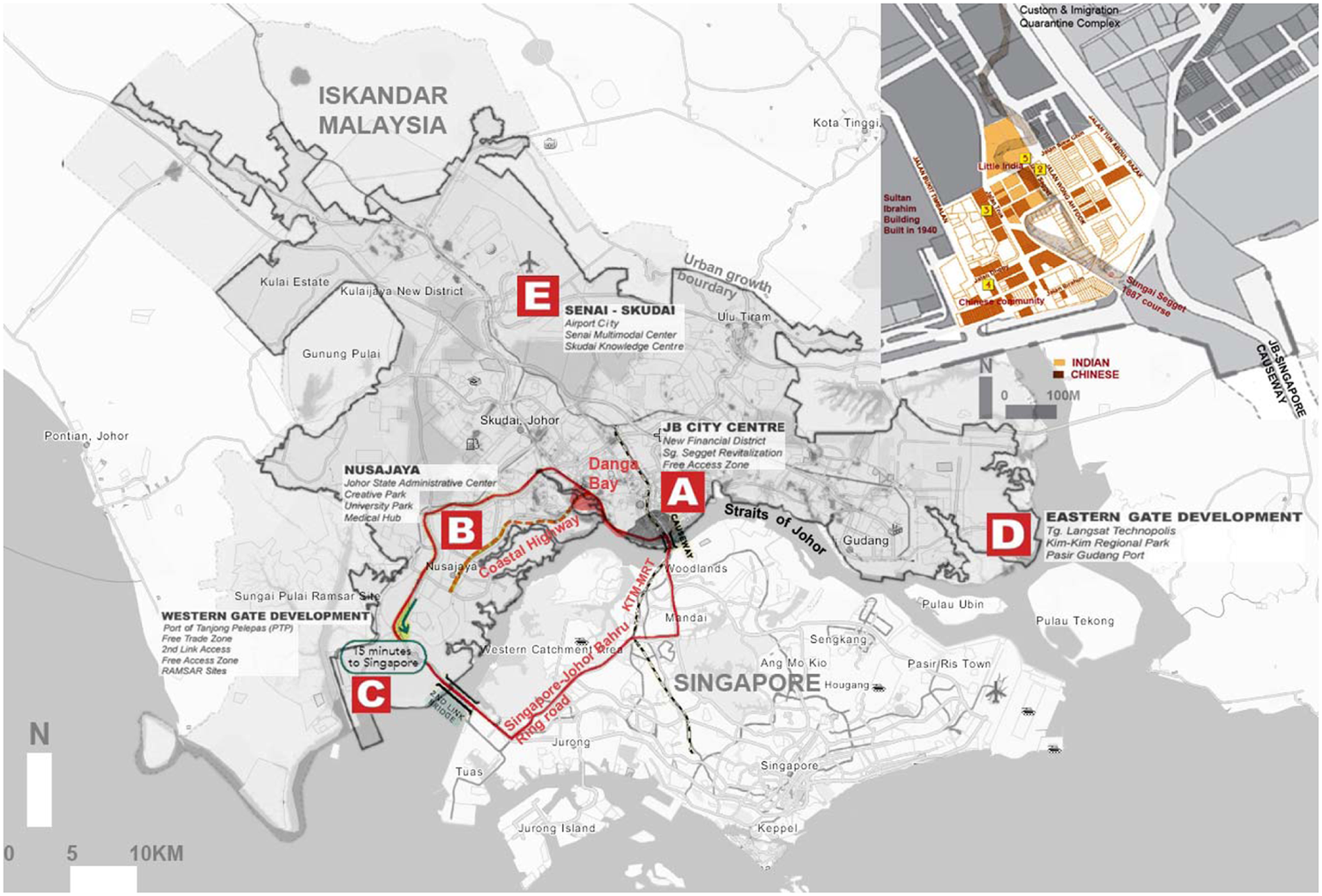
Iskandar Malaysia (shaded) and the locations of the ‘flagships’. The integration with Singapore’s development is via transport linkages such as the Singapore–Johor Bahru Ring Road and the planned KTM–MRT mass transit link, particularly with the new administrative centre at Nusajaya (Flagship B) and Johor Bahru city centre (Flagship A, the old centre: see inset).
The study was conducted from February to April 2010 and investigated urbanisation in Johor Bahru, with the second-largest urban conurbation and expansion rate in the country, 2 through multiple dimensions and scales. Section 2 discusses the political-economy-led urban change in the Singapore–Johor Bahru conurbation 3 that drives new urban development across the metropolitan region and represents the conceived space of global city-regions and ethnic/class privilege. In section 3, the post-colonial construction of Malaysia’s multiracial distinction and socio-spatial contest is observed and discussed in the perceived spaces of the old city centre through a literature review of Johor Bahru’s urban history complemented with visual surveys. In section 4, the socio-spatial transformation in the phenomenal spaces of Kampong Skudai Kiri, as a result of the conceived space in the Danga Bay development, is discussed, synthesising physical surveys, observations and random door-to-door semi-structured interviews with 60 inhabitants who have lived at the kampong for more than 15 years and are earmarked for relocation or housing upgrade led by a public–private partnership agency. As the kampong encompasses households in both legally owned/leased land plots and illegal informal settlements, we conducted further in-depth interviews with the latter group consisting of 25 foreign workers, threatened by eviction, and also 15 Malay fishermen, similarly vulnerable, although their plots are legal (the other 20 respondents were ethnic Malays in legal allotments).
In the semi-structured interviews, we explored local perceptions on how the inhabitants view the Danga Bay and Iskandar Development projects and how the developments impacted upon the local ecosystem, traditional livelihoods and cultural identity while the in-depth interviews further investigated the informal settlers’ and fishermen’s views on future forced evictions. Utilising content analysis of the interviews and local news reports to address local perceptions, the findings reveal attitudes towards and of the informal settlers. The empirical results emphasise the dialectic link between spatial and social spaces across scales in terms of marginalisation to the periphery and segregated everyday life vis-à-vis the conceived centralisation process that advocates a homogenised social space in its prescribed form of urbanisation.
The Conceived Space of the International/National Conurbation
This section discusses the production of the conceived space of international capital in collusion with national governments that manifest in Singapore–Johor Bahru’s ‘dialectic of centrality’. In the 1980s, the built-up area in Singapore, oriented towards the port, concentrated on the south of the island, while Johor Bahru was a small urban centre connected to the causeway link. From the 1990s, Singapore’s and Johor Bahru’s growth was conceived and framed at multiple scales by the notion of global city-regions. The focus of Johor’s urbanisation shifted from the old centre to the peripheries and, from the 2000s, rapid expansion has been encouraged east–west along the Strait, consciously oriented and co-ordinated with Singapore’s development.
2.1 IMS GT and Iskandar Malaysia
The global city-region is a network of transnational metropolitan nodes defined by a mutual regional and global political economy based on the spatial flows of capital, productive activity, services and human mobility (Scott et al., 2001). The Indonesia–Malaysia–Singapore Economic Growth Triangle (IMS GT) is an intergovernmental initiative based on complementary varying levels of economic development (Sien and Perry, 2003) that reinforces the historical connections between Singapore–Johor–Riau in the proximal relationships of economic core and periphery. In the transnational conurbation, Singapore became the biggest investor in Johor State’s semi-skilled labour, property and manufacturing, and basic infrastructure and utilities such as water. Singapore invested in the Indonesian islands of Batam and Bintan in the tourism sector taking advantage of the cheap labour costs. Indonesian and Malaysian workers benefit from the higher urban wage, advanced technology and currency exchange profit.
At the national level, in 2010 the Malaysian government launched the ambitious Economic Transformation Programme (ETP) to support the Vision 2020 aspiration to become a high-income economic nation by 2020. The ETP consists of three components: 1Malaysia; 4 the Government Transformation Programme; and the 10th Malaysia Plan, which focuses on the development of 12 national key economic areas (NKEAs) outlining development priorities and includes boosting property development. In this framework, Iskandar Malaysia has been identified as one of the catalysts for GDP growth through high-impact developments, with an investment of RM 43 billion, forming new centralities in designated ‘flagship projects’ (IRDA, 2011b). Since then, through public–private urban renewal and new urban/suburban projects, the city-region has experienced spatially diffused, low-density sprawl into pre-existing rural land covering an area of over 2217 square km. The precinct is envisioned/branded as a ‘sustainable conurbation of international standing’ according to the Southern Johor Economic Region Comprehensive Development Plan (SJER-CDP). 5
2.2 Perceived Space: Iskandar Malaysia as Singapore’s Periphery and Symbolic Malay Centrality
While the IMS GT city-regions have complementary functions, Singapore’s economic growth significantly influenced urban development in Iskandar Malaysia (IRDA, 2011a). At one level, Johor Bahru functions as Singapore’s dormitory suburb and 150 000 residents (including Singaporeans) cross the Strait to work in Singapore on a daily basis (Ho, 2010). This has been facilitated by Iskandar Malaysia’s increased transport integration with Singapore. The Johor Bahru–Nusajaya corridor, a coastal highway completed in 2011, is integrated via the second bridge link to Singapore’s industrial areas in Tuas and serves as a further catalyst for urbanisation, with a projected population of 500 000 by 2025 along the route. This integration is to be further complemented by the planned connection of Singapore’s Mass Rapid Transit with Malaysia’s Light Rail Transit links by 2018 to facilitate mutual economic development and attract investors and enterprises (see Figure 1).
Along the Strait with a planned polycentric urban form, the Johor–Nusajaya–Pasir Gudang economic growth corridor resembles the federal government’s Multimedia Super Corridor (MSC) linking Kuala Lumpur to Putrajaya and Cyberjaya that refashioned Malaysia’s modernisation (Bunnell, 2002, 2004; Ho, 2010) as an ‘imagined’ metropolis (King, 2008). 6 Johor’s ‘imagined city’, Kota Iskandar, is symbolically planned as the new administrative centre of Johor State and is a reproduction of Putrajaya with a modernised Islamic-Malay identity that combined Moorish and Malay-Minangkabau architectural styles. Moreover, the centre’s conception reflects the professionalism-oriented government policy that advocates for strong co-operation with the private sectors and Nusajaya developments—such as Edu-City, Newcastle University Medical Centre, Marlborough College, the SiLC industrial estate and logistics, and the integrated resort—aiming to attract global capital inflow and skilled migration.
Consistent with Jameson’s post-modern notion of space as “a cultural myth that has lost all sense of history in an all encompassing wave of the new” (Jameson, 1991, p. 307), Johor Bahru’s dialectic centre–periphery transformation is conceived as a city for consumer capitalism by the privileged groups, where the complex history and socio-cultural heterogeneity have, on the whole, been ignored in the administrative élite’s conception.
3. Perceived (Nostalgic) Space of Socioeconomic and Ethnic Conflicts
This section utilises Lefebvre’s spatial practice—the way space is interconnected with social activities, production networks and the built environment in everyday life—and dialectic of centrality to discuss the perceived ethnic segregation in Johor Bahru that has evolved with post-independence urbanisation. More recently, this ethnic segregation and discrimination have been rebranded in the current notion of 1Malaysia as cultural diversity and nostalgically promoted for national unity through Iskandar Malaysia’s urban heritage conservation and renewal plan.
3.1 Evolution of Perceived Ethnically Segregated Space
Singapore and Malaysia have been defined as ‘plural societies’—arguably rooted in the British ‘divide and rule policy’ 7 characterised by distinct racial communities where the class structure defines the capitalist mode of production based on spaces and activities (Furnivall, 1980; Abraham, 1997; Kim, 1998; Kumar and Siddique, 2008). Broadly in this structure, during the colonial era from the early 19th century to 1965, the native Malay practised agriculture in the rural kampongs; the immigrant Chinese concentrated in urban areas and engaged in commerce; the Indians worked in rubber plantations in remote rural areas; while minority groups from the Indonesian archipelago such as the Bugis and Javanese worked as waged labourers scattered along the Strait Settlement (Abraham, 1997; Ghee, 2009).
Pre-independence, Singapore functioned as an important commercial entrepôt while Johor Bahru was a small Chinese trading harbour (Lim, 2006). A dual administrative system existed, characterised by the power play between the British colonial residents and the local élites derived from the dominant ethnic groups (Evers and Korff, 2000). From the 1830s, the Chinese settled in Singapore and Tanjung Puteri harbour—later renamed Johor Bahru—to grow pepper and gambier. From 1887, immigration was encouraged by the Sultan and land allocation on both sides of Sungai Segget River and the north–south Jalan Wong Ah Fook road in the centre that linked to the Causeway Bridge to Singapore was allocated to Chinese, Indian (Tamil) and Arabic communities. Since then the Chinese, who settled in shophouses around a floating market at the harbour, dominated Johor Bahru’s city centre and controlled the trade route (Kim, 2009).
Post-independence in 1965, Singapore experienced a faster pace of urbanisation through effective urban planning, while Johor Bahru experienced state-driven urban growth through the encouragement of ethnic Malays’ rural–urban migration. This was part of the economic growth policy framed by the 1971 New Economic Policy’s (NEP) sponsorship of Bumiputera 8 engagement in the economy to eradicate extreme poverty (Amstrong and McGee, 1985; Evers and Korff, 2000; Nadarajah, 2007; UNDP, 2005) and to achieve 30 per cent Bumiputera equity in all economic sectors, including real estate, to close the economic gap with non-Bumiputera (Bunnell, 2004), particularly the Chinese. In the case of Johor, 20–40 per cent of all residential, commercial and industrial developments are allocated for Bumiputera ownership, with 15 per cent discount from the sale price in joint government–private housing projects. The manipulation of housing policy had the objective of consolidating the identity/centrality of the dominant ethnic group in the urbanisation process, consistent with former Prime Minister Mahathir Mohammed’s claims, in his 1970 book Malay Dilemma, that the Malay and other Bumiputeras are ‘definitive’ and ‘rightful’ owners of Malaysia (King, 2008). According to King, this view widens the socioeconomic gap of the whole community through the ‘equal treatment of unequals’.
Strategically benefiting from Singapore’s centrality in the regional and global economic flows, Johor Bahru (comprising four sub-districts adjoining Iskandar Malaysia) has been experiencing rapid expansion, with a total population of 2 374 778 (2010) (Department of Statistics Malaysia, 2010). Along ethnic lines, Bumiputera account for 44 per cent of the population, followed by Chinese (41.5 per cent), Indian (9.1 per cent) and other ethnic minorities (5.4 per cent). The Bumiputeras’ average annual population growth rate is 2 per cent while that of other races is about 1.5 per cent (UNDP, 2005). Additionally, the UNDP estimates that the rapid increase in foreign migrants, both legal and illegal, has accounted for a rise of 1–7 per cent of total population over the past four decades.
Despite the 1Malaysia initiative, the historical socio-spatial segregation—exacerbated by NEP—has been sustained, manifesting itself in defined cultural, economic and religious differences through the production of separate schools and curriculums, religious monuments, clubs and associations, newspapers, marketplaces and cultural festivals in public spaces. This socio-spatial segregation in the city is in accordance with the division of labour (Lefebvre, 1991), which is manifest in ethnic contests over urban spaces symbolically represented in architecture. The Chinese-style shophouses dominate the old centre with the presence of Buddhist temples. Government-imposed Muslim mosques and dewans (Malay community halls) are located at all urban centres and urban kampongs reinforce the ‘imagined’ Malay-national identity (Bunnell, 2002). Small Indian enclaves can be found around Sri Raja Mariamman Hindu temple and the Sikh temple, Gurdwara Sahib.
3.2 Chinese Economic vs Malay Political Centralities in the Old Centre
In 1997, to address the high density, congestion and degradation of the old city centre, the (Malay-dominated) local government enforced urban planning (1997 Master Plan of Johor) in the centre which was opposed by many Chinese organisations. The Arab enclave along Jalan Wong Ah Fook was transferred to the Malay-government-owned Johor Corporation and transformed into a high-density office commercial complex. Citing pollution problems, the city council (MPJB) filled and turned the Sungai Segget River into pedestrian and parking spaces resulting in the disappearance of the pre-existing Chinese ‘water-based’ marketplace.
The master plan diluted the Chinese identity of the city centre through urban renewal adding “visually distinctive buildings with Islamic features” (Johor Bahru Central District, 1997, p. 12). Many main arterial streets once named after prominent Chinese personalities from the 19th century were replaced by the Malay Sultanate and leaders’ names (Lim, 1998). These developments coincided with the suburbanisation of Johor Bahru and the decline of Chinese businesses in the old centre adversely affected by the economic crisis in 1997 and later by the serious flash floods in 2006.
Responding to the decline of the city centre and citing Singapore’s tourism-boosting urban conservation plan in the Chinatown area in the 1990s (URA, 2006; Kong, 2011), the Iskandar Malaysia plan initiated the ‘revitalising and renewable’ concept through projects such as the reinstatement and ecological regeneration of Sungai Segget River (modelled on Seoul’s Cheonggyecheon river reclamation). However, despite the plans, the perceived ‘nostalgic’ space in the city centre manifests contradictions that reinforce ethnic differences, segregation and power relations, while at the same time reflecting social plurality and continuity—albeit competing with the new centralities beyond. Today, the inner city, dominated by the Causeway (to Singapore) and the associated Customs, Immigration and Quarantine Complex, seems destined to become a transit space to Iskandar Malaysia.
3.3 Conceived Space of Privileged Consumers in New Centralities
The Johor Bahru coastal area—encompassing Johor Bahru central business district, Lido Boulevard and the Danga Bay development where Flagships A and B of Iskandar Malaysia are adjoined—has been promoted as an attractive opportunity for developers due to its location that stretches 6 km from the Causeway and 15 km to Nusajaya. The coastal development, delivered under a public–private partnership (PPP) between Malaysian-Chinese entrepreneurs and the UMNO-led government 9 (with ethnicity conveniently ignored in the capitalist mediation), will reclaim 250 metres of land to create new waterfront developments. The area will eventually consist of gated communities with higher-density urban forms and iconic architecture and the convenience of the highways to attract global upper-middle-income groups, 10 shaping the new image of Johor Bahru while displacing the mangroves and pre-existing kampongs and ushering inevitable social transformation (see Figure 2).
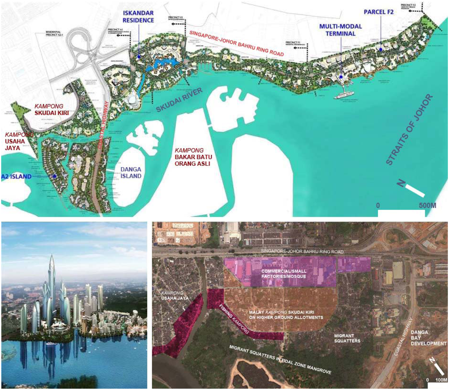
Proposed master plan (top) and artist’s impression (lower left) of the new business-residential development in Danga Bay that overwhelms pre-existing kampongs
Many contemporary housing problems in Johor Bahru arose from the state-sponsored rural–urban migration of Bumiputera and, lately, foreign expatriates that resulted in housing unaffordability for the middle- and low-income residents (Lee, 2005; Ahmad Ariffian and Mohd Razali, 2008). The non-Malay poor, particularly the ethnic Indians, cannot even affordlow-cost housing due to corruption amongst the politicians and civil servants (Ho, 2010, pp. 100–106). These are critical social inequality issues embedded in housing practices. On the other hand, the government imposes upgrading and forced evictions of kampongs which include Bumiputera inhabitants, illustrative of King’s ‘equal treatment of unequals’ comment (King, 2008). This is discussed in the next section in the case of Kampong Skudai Kiri, threatened by Danga Bay development.
4. ‘Lived’ Space in Urban Kampongs
In 1998, there was serious concern about the proliferation of squatter settlements especially in city centres with the rural–urban migration of the population and the influx of foreign labourers making their way (legally and illegally) into this country. Consequently, various efforts have been taken by the Government to overcome this problem and targeting that the country will achieve a zero-squatter position by the year 2005. This is made possible by relocating these squatters to other areas where the majority of them are accommodated in the formal housing schemes (Ministry of Housing and Local Government Malaysia, 2001, p. 34).
The middle class have emerged in Malaysian cities since the poverty eradication policies of NEP 1971–90 to ETP 2020 (Abdul Rahman Embong, 2001; UNDP, 2005). As a result of these economic and social restructuring policies, the Malay kampongs are often absorbed by the urbanisation processes—being either upgraded into denser housing or replaced with new urban centres (taman). Many urban Malay kampongs in Johor Bahru had been settled before the 1970s such as Kampongs Skudai Kiri and Usaha Jaya and also Orang Asli (indigenous) communities in Kampong Bakar Batu and Kampong Melayu located in Nusajaya that were fishing communities before independence and are now vulnerable to relocation. In 2003, contemporaneous with the start of the Danga Bay project, the authority launched a pilot survey and public announcement of the redevelopment project at Kampong Skudai Kiri. The redevelopment process manifested many of the socioeconomic and ethnic conflicts already discussed.
4.1 No Space for Urban Kampong?
Since independence, more than 10 urban kampongs in Johor Bahru’s inner city have been displaced and fragmented by new developments, golf courses and the construction of highways (Lim Pui, 2006). Recent urban growth tends to involve the eradication of old settlements through forced evictions as a result of the government-driven ‘zero squatter policy’ launched in 2005. At the time, the plan was for the complete relocation of all the residents by the end of 2007 (Nadarajah, 2007). A social activist lamented
The inhumane treatment and the failure to address the basic housing needs of the poor and marginalized is of great concern. Rather than support such a policy, the State Government should abandon it and make an open declaration that they will desist from using the draconian Essential (Clearance of Squatters) Regulations promulgated under the Emergency Ordinance (Sreenevasan, 2008).
Moreover, the categorisation of squatter settlements is problematic and is often (intentionally?) mixed up with the traditional settlements existing before independence. 11 The government conceives squatter settlements as housing quarters with poor infrastructure conditions that encompass both informal settlements that have encroached on public lands and also traditional urban kampongs with hard-core poverty that signifies the failure of Malay modernisation, according to UMNO-centred Malay nationalism (Bunnell, 2002).
In the case of Kampong Skudai Kiri, the settlements appear in two forms. The legal, tenured settlement comprises the Bumiputera, in the pre-existing fishing kampong, and those who migrated from rural plantations to urban employment in the 1970s. This part is located on land that was given by the late Sultan Ibrahim to his Johor Military Force personnel under the state’s land allocation system in 1950 (Tan, 2010). The number of households dramatically expanded from the original 15 Malay families to 784 families within 150 allotments—both freehold (45 per cent) and leasehold (55 per cent on state land with 60–99 year leases) on 70.47 acres. The second illegal informal settlement is composed of migrant workers in 683 households, mainly Indonesians, who encroached into public lands with close proximity to employment, particularly in construction sites nearby.
The Iskandar Malaysia plan advocates for the clearance of squatters, claiming that this will improve the polluted river ways flowing into the Straits of Johor. With the view of unkempt kampongs as squatters, the government plans to displace the illegal squatters with upper-income high-rise residences and to upgrade the old legal Malay houses into higher-density flats. The government-owned enterprise, Urban Development Authority Land Holdings (UDA), utilises the PPP model to reclaim property for reblocking and redevelopment purposes. Collaborating with UDA, Program Pembangunan Tanah Bersepakat (PTB), a government agency responsible for social housing and land readjustment, reorganises land plots, through co-operation with the landowners, with provision for sufficient infrastructure and community facilities (PTB, 2007). The resultant 2005 PTB plan proposed three upgraded housing block alternatives for the original inhabitants. From public hearings conducted by the PTB since 2003, only 80 of 784 households have agreed to relocate, yet these people cannot afford the new properties costing RM300 000–500 000, despite the Bumiputera policy that offers ethnic Malays subsidised housing. Moreover, the offer of flats rather than freehold land tenure and very low compensation to the Malay landowners provided strong disincentives to move and, hence, no further progress has been made (based on a PTB officer’s brief and the interviews).
Since then, the UDA has initiated a relocation plan for the inhabitants of the fishing kampong and squatters to low-cost flats at Taman Bandar Baru UDA in the hinterland 20 km away. However, the Malay fishermen were dissatisfied with the compensation and the relocation plan as their settlements are legal. Fishermen informants mentioned that the compensation allows for only 4000 Ringgits/household to the illegal squatters and up to 30 000 Ringgits/household to the 98 landowners. More critical for them, the new housing is not located by the riverside. The informal settlers had been offered relocation to new rental flats by the end of 2011; however, resistance amongst the fishermen and the migrant workers still persists.
4.2 Pressures on Urban Environment and Livelihoods
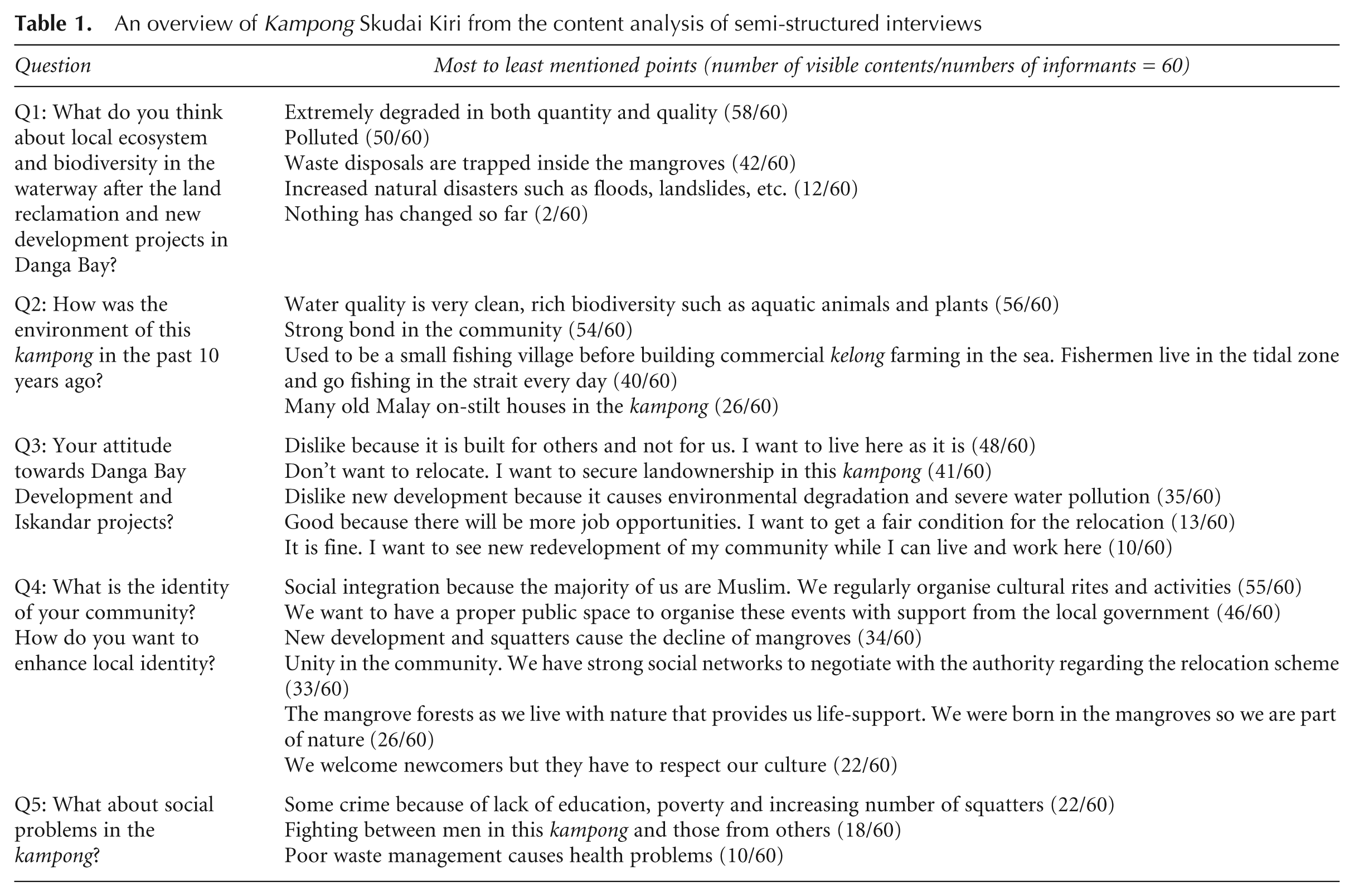
According to the semi-structured interviews with 60 mixed ethnic inhabitants who have been living in the kampong from 15 to 45 years; 12 all the respondents were aware of the new developments and foresee the new projects as “a privilege to expatriates and local élite but not for kampongers”. They also desire secured land tenure and in response to Question 3, most respondents’ views are consistent with the representative statement “I want my own landownership and stay here as it is. Whatever the new development would be, it should not threaten our local environment and way of life” (see Table 1).
An overview of Kampong Skudai Kiri from the content analysis of semi-structured interviews
According to the semi-structured interviews with the Malays on their views towards social problems and integration with others, 25 per cent of respondents mentioned that drugs and crime in the neighbourhood have been compounded with problems from increasing numbers of foreign migrants. These issues have also been consistently reported by many local newspapers (Low, 2007; Aivizanoorwani Shah, 2009), perpetuating a negative image of the kampong. In contrast, 75 per cent of respondents experience ‘lived’ space as ‘a landscape of nostalgia for an idyllic rural origin’. Social networks and integration such as Gotong-Royong, Kumpulan yaksin and Kenduri (village co-operation and performance for wedding ceremonies) are commonly practised in these kampongs. The Malays state that these cultural activities symbolise Malay-Muslim identity and culturally incorporate Indonesian migrants with the community. These contradicting views suggest an exclusion/inclusion in lived experiences—even in and around the kampongs.
Further in-depth interviews with 15 fishermen reveal how the Danga Bay and Iskandar projects impact on local environment and livelihoods: 85 per cent of respondents had witnessed the deprivation of the natural environment and the loss of biodiversity since early 2000s when the construction of the land reclamation and Danga Bay projects commenced—in contradiction to the environmentally friendly approach claims of Iskandar Malaysia—while 15 per cent of fishermen complained about poor waste management in the kampong and the construction site. The fishing kampong is also perceived as ‘self-sustaining’, relying on local produce from fishery, home poultry, fruit trees and vegetables from nearby mangroves. The fishermen who have lived there for more than 30 years stated that the water has become dramatically polluted with the channel changing course as a result of land reclamation along the banks and for Danga Island, and with the construction of the adjacent apartment blocks. This has resulted in a decline in aquatic fauna which the fishermen have relied on for generations. A fisherman leader respondent mentioned
Some fishermen moved out further away from the city to the west of the Strait as they can’t afford the expensive plot of land. Finally, they turn themselves into rental tenants and become unskilled urban workers. I am the last fisherman standing here because I don’t want to leave this home. I will die at this place.
He further asserts that the inhabitants that the government categorised as ‘squatters’ have in fact been living on the late Sultan’s lands for two generations. Some fishermen had previously moved from the filled SungaiSegget and hence are reluctant to move again. Many feel a sense of attachment to the place and the late Sultan as both have provided prosperity to their families.
In contrast, in-depth interviews with 25 migrants revealed issues of exclusion by the government. Half of the interviewees depend on construction and small mechanical jobs such as car and motorbike repair in the kampong, while the other half are in the informal economy working as handymen and street hawkers, or are unemployed. The mangrove-encroaching settlement has poor basic infrastructure, lacking proper sanitation, a clean water supply, a sewerage system and solid waste management. All the interviewees stated that the local council stopped providing basic services because the settlement is considered illegal and earmarked for eviction from its now-prime location. They are reluctant to move from this kampong as it is accessible to urban public transport and its proximity to work, and they cannot afford rent in the city centre. Reflecting this view, an urban migrant worker mentioned “We want to live here because of the close proximity to work and service amenities and good public transport although the environment is polluted”. In fact, some have already reclaimed more land-fill to build houses from the construction waste and forest timber in the tidal zone
Nowadays the environment and biodiversity have been extremely degraded in both quantity and quality—many litter flow from the upstream development and are trapped by the mangroves. They flood away with the high tide. We adapted ourselves in this tidal zone. Although I have no work, I can survive with rich natural resources here 10 years ago but not now (unemployed migrant).
5. Conclusion
The analysis of the social production of perceived, conceived and lived spaces in Johor Bahru reveals a dialectic of centrality manifested with social exclusion and privatisation that often results in socio-spatial segregation and tensions. The paper has examined this phenomenon in parts of Iskandar Malaysia Flagships A and B, characterised by segregation as a result of ethnic and socioeconomic polarisation embedded in Malaysian social formation since the colonial era. Post-independence, government deterministic planning policies and public–private developments have aggressively strived for modernisation, privatised spaces, privileged the Bumiputera and encouraged further social segregation. In practice, the political narratives and economic transformation of Iskandar Malaysia promote socio-spatial homogeneity that favours the upper-middle-income groups while paying lip service to cultural diversity and community participation in development.
Consistent with Lefebvre’s ‘dialectic of centrality’ that is contradictory in a centre/periphery and homogenisation/differentiation dialectic, the transformation of Johor Bahru from the pre-existing Chinese-dominated harbour town to the conceived international metropolis reveals a socio-spatial gathering and dispersion of ethnic and socioeconomic groups. The state ideology constructs Kota Iskandar (associated with ‘Malay’ identity) and its surrounding precincts as the new centre while relegating the old Johor Bahru centre (once dominated by the Chinese) as an historical periphery. Despite plans for ‘revitalisation’, the original centre has to compete with new, ‘post-modern hyperspace’ (Dear, 2000) centres only 10–20 km away. Visitors crossing from Singapore can easily bypass the old centre via the highways which makes economic revitalisation more difficult. What will happen in the near future when the government administration moves to the planned Kota Iskandar precinct? Similarly, the traditional fishing kampongs and ‘water-based’ markets, perceived as visually unpleasant and culturally antiquated, have consistently been displaced with modern developments, evident in the history of the old centre where a vibrant kampong at Sungai Segget was erased in the revitalisation process. This dialectic is now being repeated on a regional scale in Iskandar Malaysia’s accelerated growth policy.
Concurring with Lefebvre’s argument and Gramsci’s notion of cultural hegemony of power over space, conceived space often overcomes lived space in the state ideology construction of Bumiputera supremacy. The spatialisation of conceived space is not only driven by the property market based on socioeconomic differentiation and profit-making, but is determined by planning mechanisms to reinforce Malay-Muslim identity allied with the desired middle-upper-income forms and lifestyles. While the urban poor in Malaysia are officially reported as 2 per cent of the total population, they become more significant in the context of rapid urbanisation, posing challenges on demands for affordable housing, urban environmental deprivation and climate change mitigation (UNDP, 2005: UN-HABITAT, 2010). Moreover, the transnational conurbation, of which Johor Bahru forms a part, poses significant challenges to the state and planners to accommodate the massive influx of foreign workers, evident in the homelessness in the centre and the informal settlements. This is a Malay dilemma with the aspiration to transform rapidly into a First World economy, yet relying on extensive labour from the poorer neighbouring countries to drive it. Hence migrant workers, encroaching in the urban fringes, are at risk and vulnerable in this process of economic transformation, being excluded from the socio-spatial development.
Urban kampongs have functioned as an interface between urban/rural landscapes and the formal/informal economy that is adaptable to both the natural environment and everyday life. The ecological and socio-cultural values of place are inevitably destroyed as rapid urbanisation transforms the kampongs and their environs into new alienated urban forms such as the high-rise dwellings in Danga Bay. The provision of ‘affordable’ housing in the higher-density flats is, in fact, only affordable to particular ethnic and income groups—and certainly not to the poor and foreign migrants. Moreover, the fishermen are also denied access to natural resources that threaten their livelihoods and, to some extent, future urban food security. This lack of tenure security and access to resources for the disadvantaged groups causes severe deprivation, social stigmatisation and inequality leading to poverty concentration and homelessness, reinforcing the exclusion of the underclass. These problems relating to human rights and basic accessibility to resources and associated issues such as health, education, pollution and crime are often neglected in the conceived urban developments.
It is a highly sensitive issue to address ethnic relations and inequality in the Malaysian context, where urban spaces are habitually segregated by ethnicity and the government has been inclined to manipulate the conception and perception of space to reinforce the symbolic modern Muslim-Malay identity. The Malay-dominated government agencies perform as both urban planner and entrepreneur, allied with the ethnic Chinese developers, and dominate the property market in all socioeconomic sectors ranging from high-end Nusajaya, Danga Bay to UDA social housing that often narrowly benefit particular income and ethnic groups. Moreover, the predominant emphasis on physical renewal alone is insufficient and a systematic approach is required that addresses the range of interrelated issues causing inequality and it is argued that the disadvantaged groups should also benefit from the new centralities. On that note, the full effects of the praxis will not be known until its ‘imagined’ completion in 2025, to be concurrent with Malaysia’s achievement of high-income economic status.
Footnotes
Notes
Funding Statement
This research received no specific grant from any funding agency in the public, commercial or not-for-profit sectors.