
Abstract
Defining city-region boundaries for governance or policy requires robust data analysis reflecting a conceptualisation of city-regions. Geddes introduced the concept to England and both fundamental and contingent features he identified remain valid. Subsequent work has not clarified issues raised by the contingent features and one of these—whether or not cities dominate the region definitions—here structures the review of city-region definition methods. Following a historical review of the failure of proposals for English city-region governance geography—which ascribes a key role in those failures to institutional inertia fuelled by rural interests—a review of the ‘city-centric’ methods which exacerbate rural opposition shows they fail to meet essential requirements. By contrast a ‘regions first’ approach to city-region definition is shown capable of implementing all the fundamental features of the concept, including the analysis of flows over and above those of commuting.
Introduction
This paper considers city-regions in the context of a general problem that can arise in implementing many spatial economic policies and that has long been the focus of academic research (for example, Fox and Kumar, 1965; Karlsson and Olsson, 2006)—i.e. how best to define functional economic areas (FEAs). Research to define optimal groupings of areas in wider territories is termed functional regionalisation and is one form of quantitative taxonomy (Sneath and Sokal, 1973). In this paper, the empirical challenge is to delineate policy-relevant city-region boundaries in England by analysing spatial economic data, but the methodological orientation of the paper gives it a wider international relevance.
The definition of city-regions is of increasing policy interest internationally, as illustrated by recent work in the OECD on territorial development which prompted research on city-regions as well as other FEAs (OECD, 2002, 2006; Brezzi et al., 2012). By contrast, the new UK coalition government abolished most of the English spatial policies based on FEAs that its predecessor created (DCLG Committee, 2011). Harrison (2012a) echoes other commentators in seeing the interest in FEAs of the 1997–2010 government as a reaction to its earlier failure to introduce democratic devolution at the broad region scale that features strongly in the governance of most similar countries. Regional-scale policy is ideologically unacceptable to the new coalition government, and in their austerity strategy responding to recession there was no future for governance tiers whose recent creation implied that their existence was not essential.
This paper begins by outlining the historical context of English sub-national governance geography, which has prompted key writing that shaped the city-region concept. From this review, the paper derives basic principles for city-region definitions for governance in England. These requirements are then used to critically assess a 21st-century revival of policy interest in city-regions in England, and its practical expression as part of new sub-national governance structures. The third part of the paper turns to the empirical application of the city-region definition principles, proceeding within two broad sections that reflect a distinction between what are termed deductive and inductive approaches. Finally, a reflection on the general conclusions drawn from the retrospective parts of the paper leads to a brief evaluation of the boundaries produced here as areas for governance.
1. History of the City-region Concept in the Governance of England
Counties formed the structure of sub-national governance in medieval England and it is relevant to the focus here on city-regions that the names of most counties are taken from a selected settlement, with such counties named as the ‘shire’ or area containing that settlement. In some cases what became the county town had not dominated that area: it gained its importance from the ‘shiring’ process which selected it (see Marten, 2008). After its uniquely early industrialisation, England became heavily urbanised and this challenged its sub-national governance structure due to spiralling populations of nascent conurbations that often straddled county boundaries drawn centuries earlier. A reform finally occurred in 1888 but inertia and nostalgia weighed against radical restructuring, so the main outcome of this boundary modernisation was the creation of County Boroughs which each circumscribed one major urban area. The result was that the ‘remainder’ historical counties were administered separately from principal settlements in their midst. Thus historical counties like Nottinghamshire—which arguably had been an early form of city-region—found that the 1888 reform had dismembered them by separating ‘their city’ from their more rural areas.
Critiques of this new English administrative structure soon followed and one of these included the first British use of the term city-region. Geddes (1915) highlighted governance issues when calling for “a thorough revision of our traditional ideas and boundaries of country and town” (pp. 28–29). In now examining the city-region conceptualisation of Geddes (1915), a possible confusion of terminology arises. His first use of the term city-regions (p. 31) includes no definition but the next (p. 34) defines them as “town aggregates” and in fact suggests “conurbations” as the more appropriate new term. Today, the city-region and conurbation concepts are clearly differentiated: the latter applies exclusively to urbanised areas, explicitly excluding the ‘country’ areas that Geddes (1915) demanded should be grouped with urban areas. Fawcett (1922) defined a set of conurbations as exclusively built-up areas and thus established the difference between the two terms.
Geddes (1915) saw the linking of rural with urban in city-regions stemming from an “extension and acceleration of the means of communication” allowing men [sic] to have longer commuting distances “without too great deduction from their day’s work” (p. 41). England has a very closely spaced urban network so once-separate local labour markets become integrated through lengthened commuting flows. Geddes saw that a possible consequence was relatively nearby cities—like Glasgow and Edinburgh—becoming linked in regions he called “bi-polar” (pp. 39–40). In this foresight about polycentric developments, he undermined the persisting assumption that each city-region is simply identified as the commuting hinterland of one individual city. Analyses of commuting patterns did became possible when the 1921 census became the first to record where people worked, but the new commuting data led to very little “empirical work at that time on the delimitation of the spheres of influence of cities” (Hall, 1985, p. 117). Somewhat ironically given that it was Fawcett (1919) who had sketched the first widely known definitions of city-based regions to fully partition England, when the 1921 census offered commuting data to allow rigorous definitions of such regions, he instead used other census data to define conurbations. Without any such rigorous definitions to illustrate issues that need resolving in order to move from outline concept to actual boundaries, questions such as whether all city-regions must have just one dominant city remained unresolved.
Two other city-region definition issues can be traced to Geddes (1915). The first is revealed by several references to a ‘new heptarchy’ of city-regions in Britain. In practice, these seven regions excluded, for example, the substantial city of Bristol (and indeed the rest of south-west England). This is very significant in relation to governance because a set of regions only partially covering the country may be useful for policies tackling issues that are limited to some areas (for example, metropolitan-scale transport planning), but no area can be simply ‘left off the map’ when defining boundaries for general territorial governance or delivery of universal policies.
One further issue for city-region definitions is implicit in text where Geddes (1915) re-emphasises urban and rural linkages
This idea, though as old as geographical science, and though expressed in such a term as ‘County Town’, and implicit in ‘Port’, ‘Cathedral City’ etc., etc., is in our present time too apt to be forgotten (Geddes, 1915, p. 352).
The point here is that these older terms not only presume a linkage of urban and rural, they also recognise a possibility of the region taking ontological precedence over the city. For example, county town status can be transferred between places in the same county: the wider territory (the county, which is the region of this form of city-region) is the definitive entity, so the identity of ‘its’ city is secondary.
If city-regions are ‘regions first’ then their definitions should begin with the identification of appropriate territories; only later might there be a procedure identifying where—or indeed whether—cities lie within them. This is very different from ‘city-centric’ strategies that first find cities then draw boundaries round their hinterlands (see Spotila, 2000), the approach which not only is the most familiar but that also has been prominent in the recent policy debates on city-regions, due to the widespread view that cities are the main source of future economic growth. For the present paper, the crucial point is that there is an alternative conception of city-regions, which does not presume such a dominant role for the city. Sizeable regions in modern countries like England are all likely to house a full set of the services that tend to cluster in larger cities—so sizeable regions are likely to include cities—but with the ‘regions first’ model this is a contingency, rather than the necessary condition that it is of the city-centric conception of city-regions. As will be seen later, an additional aspect to the question of whether the concept of city-regions inherently privileges the role of cities is the resistance this can generate due to a long-established English ‘anti-urbanism’ (Mandler, 1997).
The ideas of Geddes (1915) were repeatedly revisited as the sub-national governance of England remained unreformed. Gilbert (1939), for example, called for research to provide evidence for restructuring “on a sound geographical basis” (p. 44), leading geographer Taylor (1942) to illustrate how the “functional region, the region of circulation” (p. 63) was the relevant spatial unit for planning. However, a comprehensive review of sub-national governance in England did not occur until the 1960s when geographers did generate an evidence base which emphasised functional linkages including commuting patterns (Redcliffe-Maud and Wood, 1974). The report of this Royal Commission (Redcliffe-Maud, 1969) recognised the logic of city-regions but the English dislike of radical change led to compromises, prompting one Commissioner to separately argue for a set of city-region definitions with largely “self-contained” commuting flows in particular (Senior, 1969, p. 48). In fact the subsequent 1974 reform repeated earlier practice in minimising change to the status quo (Elcock, 1994). In the later decades, several partial revisions—with no substantial evidence base—have had the net effect of shifting English local authority geography back towards the strict separation of major cities from their rural surroundings.
Basing a conceptualisation of city-regions on now-historical texts is partly justified by an initial statement of a recent academic review recognising that the concept had for some time “not received the attention that it deserves” (Parr, 2005, p. 556). The review reaffirmed key points by Geddes (1915), such as that city-regions develop as a result of economic trends deepening the linkage of urban and rural areas through commuting and other flows. One consequence of this understanding that city-regions reflect processes of change over time is that their defined boundaries need periodic updating. Parr (2005) echoes the three contingent aspects of city-regions that have been noted here as part of the conceptualisation of Geddes
— some city-regions are polycentric;
— some sets of city-regions are non-exhaustive (ie. they leave some parts of the territory unallocated);
— some contexts make it more appropriate to define the set of regions first before looking for any cities within them.
By way of summary, three definitive features of the city-region concept can be identified here as fundamental, as indeed they were in the original ideas outlined by Geddes (1915)
— unlike the conurbations, city-regions extend to include rural areas;
— as other FEAs, city-regions are fairly self-contained local economies;
— commuting flows are one—but only one—main way that constituent areas of city-regions are linked, so flow datasets provide the basis for defining city-region boundaries.
It may be unsurprising there has been little empirical research defining city-regions in ways that entirely satisfy these principles, especially given the ideal that other evidence in addition to commuting flows will be analysed: the potential scale of this challenge can be seen from the long list of factors Dickinson (1961) considered relevant when defining “the limits of the city” (p. 534).
2. The City-region in English Sub-national Governance Today
Despite times in the 20th century when city-regions were considered appropriate geography for English sub-national governance, they were never adopted in practice. There has been renewed policy interest in them in the 21st century for two reasons. First, the previous government aimed to devolve more responsibility for policies requiring spatial implementation to regional and sub-regional bodies in England—a process Lloyd and Peel (2008) note involved city-regions in Scotland. The basic subsidiarity logic (RTPI, 2008) called for policy-making and implementation at the lowest possible scale, which for spatial planning and economic development leads to a focus on FEAs like city-regions (Marvin et al., 2006). The other reason for the turn towards city-regions stemmed from recent academic emphases on city agglomeration driving economic growth (for example, Combes et al., 2005) and the current government is following this city focus of its predecessor (BIS and DCLG, 2010). This tends to lead to city-region definitions as a ‘city with its region’ and not the alternative where regions—not cities—have primacy. This implicit marginalisation of rural areas is unwelcome to the strong rural interest-groups who underpin persistent resistance to radical restructuring of governance in England (see Pemberton and Goodwin, 2010). (In a similar situation in the US, Killian and Tolbert (1993) reported that rural development policy-makers claimed ‘urban bias’ was inherent in officially defined FEAs.)
The city focus of the English city-region discourse might have been defused by demonstrating that city-region definitions can acknowledge the regional status of more rural areas, but researchers (including the present author) commissioned by the government to map English city-regions instead emphasised uncertainty, highlighting a ‘fuzziness’ of city-region boundaries (Robson et al., 2006). The response by government was to devolve the task of defining city-regions and other types of FEA (HM Government, 2008). One main reason for this was that the devolution policy depended upon a group of local authorities (LAs) forming a ‘coalition of the willing’ (Harrison, 2012b). FEAs defined centrally by government might group LAs who were unwilling to collaborate; the geographical laissez faire approach to defining FEAs left the definitions to the key interested parties. In fact, this approach had been earlier applied to a new policy on planning for housing: Ferarri et al. (2011) report how the result was that the housing market areas which LAs then defined often failed to meet the objective of being spatially coherent for planning.
The new government emphasises ‘localism’ (Curtis, 2011) so unsurprisingly in creating new Local Economic Partnerships (LEPs) it followed the same laissez faire process of boundary definition. One condition for accepting LEP proposals was their areas being FEAs, but the guidance on FEA definition is very loose (DCLG, 2010). Some of the approved LEPs are styled City-regions but their areas are not credible as FEAs (Pike et al., 2012). Thus while in LEPs England appears to have finally embraced city-regions in its sub-national governance, with their laissez faire designation process they fall short of the principles set out here. For example, the acknowledged ‘trail-blazer’ Greater Manchester City-region is limited to the conurbation, including none of its rural surroundings. In short then, at present in England plausible contemporary city-region definitions for governance do not exist.
3. Defining Policy Boundaries in England at the City-region Scale
Producing city-region boundaries fit for governance starts with the requirements for any area definition process. In general, the definitions must be both robust—being based on data known to be reliable across all areas—and also plausible, with boundaries that broadly conform to expectations. Parliamentary examination of the widely criticised definition of LEPs (BIS Committee, 2010) echoed the conceptual discussion earlier in calling for areas that are “reasonably self-contained and coherent” (para. 35). This raises the practical issue of finding reliable relevant datasets to analyse so as to define regions that are self-contained. The familiar response is to analyse commuting flows but this cannot adequately ‘proxy’ for the patterns in other relevant forms of interaction (Sohn, 2005). The challenge of data availability is heightened by the need for fine geographical scale flow data, with the following types of information needing to be considered.
First, although labour market area boundaries do not offer a ‘one shot’ solution for the definition of city-regions, commuting patterns are undeniably important evidence. Secondly, several early FEA definitions used migration data (for example, Hemmasi, 1980); work in England recently suggests that migration patterns can differ notably from commuting (Hincks and Wong, 2010) so migrant flow analyses can enrich definitions based on commuting flows, as with recent housing market area definitions (Jones et al., 2012).
Thirdly, while links between firms and suppliers seem relevant, modern logistics support lengthy supply chains so relatively few firms now trade locally (and in practice there is no available relevant dataset at the local scale). Thurstain-Goodwin and Unwin (2000) provide a strong definition of retail centres but no available dataset helps to define their market areas. Data on usage of public services like universities or airports can reveal catchment areas, but they offer less reliable guidance in areas remote from such facilities. Transport facilities generally may seem relevant because if localities are well connected they may be more intensely linked, but transport links alone do not prove a strong linkage as most transport networks are created to service national needs more than flows within city-regions (for example, the highest level of provision is at key nodes in national networks, and such locations may be weakly connected into any city-region).
Finally, region definitions based on mobile phone traffic data are a new option but still experimental (see Candia et al., 2008). Moreover, in England there are no publicly available datasets.
The conclusion drawn here is that meeting the aspiration to broaden city-region definitions beyond their usual dependence upon commuting flow data will, at least in England, need to begin by analysing migration flows.
This paper earlier emphasised the possibility of some city-regions not being dominated by a single centre, noting that this conceptual flexibility was valuable in a modern country like England with some polycentric regions comprising networks of urban or rural areas linked by multidirectional flows. Looking at labour market areas specifically, van der Laan and Schalke (2001) argued that boundaries should overlap in the more complex urban systems. Few if any countries have overlapping boundaries for a single policy or ‘tier’ of governance, due to the risk of conflicting policies being adopted by the regions covering the same area. (Note, however, that some of the LEPs do have overlapping areas, but their lack of either significant resources or democratic mandate means that there are no immediate prospects of real difficulties.)
On the general issue of region definition methods, van der Laan and Schalke (op cit) distinguished between deductive and inductive approaches
— Deductive methods initially identify urban centres, then add areas supplying commuters to each centre (for example, Arbuckle, 1998)
— By contrast, the inductive methods have no imposed internal structure and so can readily identify polycentric regions.
These two approaches will now be considered in turn.
3.1 Definitions Based on Identifying Central Cities
The deductive model of a centre and its hinterland is familiar in policy discourse but, as noted, its urban emphasis makes it unpalatable to English rural interest-groups: this problem is exacerbated by these methods often excluding remote areas altogether (for example, Cheshire and Gornostaeva, 2002). Most deductive methods only analyse commuting flows to centres from ‘catchment areas’ but this distorts modern complex urban systems which also feature reverse commuting among flows in many different directions. Analysing all these multidirectional flows between every settlement would reduce the simplicity of centre-based methods which is their key attraction.
For any region definitions that initially identify cities, the key decisions are the choice of variable(s)—and their threshold(s)—that distinguish cities from other places. This involves a trade-off between setting low thresholds, so as to include more centres and reduce the risk of large excluded areas, and higher thresholds to avoid the more urbanised regions having many nearby centres qualifying. The latter inclusive approach generates the need for additional processes to amalgamate centres which are more realistically seen as part of the same city-region. Such extra processes involve another choice of variable(s)—and their threshold(s)—to group candidate cities. Thus once again applying deductive methods to modern urban systems can lead to unacceptable results unless their initial simplicity is undermined by introducing extra technicalities.
There is also the critical decision over the ‘building block’ areas to assess as candidates to be central cities. In most countries, a set of LA areas are the default option, but in many countries LAs confound comparisons of the ‘status’ of places due to inconsistent bounding of cities (Cörvers et al., 2009). One response is to amalgamate underbounded LAs (see Forstall et al., 2009) so that they can pass thresholds set for central cities. Here again, the simplicity of the centre-based approach is being undermined to improve its results, just as was necessary in recent definitions of OECD Metropolitan Regions (Brezzi et al., 2012).
Figure 1 illustrates these issues in England. (Note that Wales to the west and Scotland to the north are not considered here because one of the datasets used draws on data only available for England.) Figure 1 has as its background the counties created in 1974 when LAs were last restructured nationally. Many of these 46 counties were based on a historical county and this makes them as close to an established form of city-region as exists in England: hence they offer some evidence on the question of how many city-regions England should be divided into.
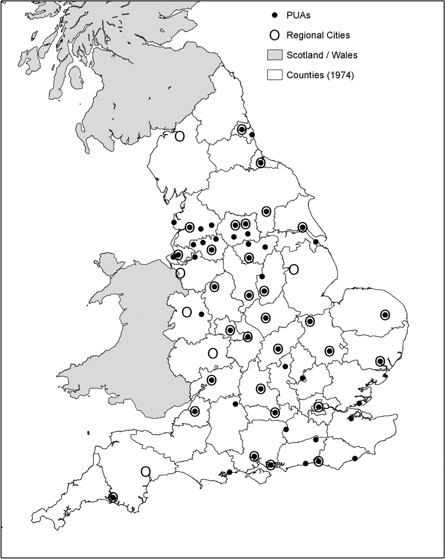
Selected cities or large urban areas in England.
Figure 1 uses small filled circles (some surrounded by larger open circles, whose meaning is detailed later) for the 56 Primary Urban Areas (PUAs) defined by Parkinson et al. (2006) as the main urban areas of England. PUAs’ populations exceeded 125,000 in built-up areas defined precisely using very small areas. Parts of northern England include many PUAs near each other, indicating that size alone cannot identify the cities whose role is to provide key services to many surrounding areas, given that such services have become ever more spatially concentrated since Carruthers (1967) recognised the underservicing of large towns in England near even larger cities. Each cluster of closely spaced PUAs will tend to include one central city plus some smaller—but still large—towns near the central city. Figure 1 shows that this pattern was recognised by the country boundaries created in 1974 which include the northern Metropolitan Counties that each embrace many heavily urbanised areas.
The location of high-level services is one basis for defining central cities. Figure 1 illustrates this option, with open circles showing 36 Regional Cities which possess over half of a set of 16 characteristics indicative of nodality—being a key centre for surrounding settlements in relation to commerce, public services (both in the present and historically), the media, transport and communications (Charles et al., 1999). This analysis relied on prior research to divide the country into candidate ‘places’ so that the vagaries of LA areas did not distort the results (Coombes, 2000). Figure 1 shows that many of the PUAs clustered in the north are not Regional Cities because they have few central city services. It may be more surprising that fully 1 in 6 Regional Cities are not among the 56 PUAs (Figure 1 shows these as fully open circles). Whereas the PUAs which are not Regional Cities are mostly in the urbanised ‘spine’ of England, all of the six non-PUA Regional Cities are located closer to the margins of the country. These more rural areas—spreading into adjacent areas outside England—have also gained the services that characterise a Regional City but their sparser populations drive insufficient urban growth for those cities to become PUAs. It is this process of a small centre providing the services required by a more rural area that is characteristic of the territories liable to be less well represented by a ‘city-centric’ rather than a ‘region first’ approach to defining city-regions.
Hall et al. (2001) reported a similar analysis of urban status characteristics, but analysed LA areas and then relied on an initial judgemental aggregation of some of the areas to limit distortion of the results. The findings from both these earlier service analysis studies are drawn on by Robson et al. (2006) when identifying 39 ‘nodes’ of a set of city-regions that are foregrounded in governance debates by Marvin et al. (2006), but here too LAs were used and several arbitrary judgements were introduced to limit the unsatisfactory nature of the results. The findings from reviewing these studies prompt mostly discouraging conclusions about the identification of central cities
— In the case of England, there are probably around 40 main central cities;
— No consensus emerged as to thresholds, or even criteria, for city status;
— Key service centres in rural areas may be missed by simple size criteria;
— Lower thresholds on criteria are needed to find cities across the country;
— Lower thresholds will also find multiple centres that need amalgamating;
— Analyses using LA areas face a greater amalgamation task;
— Amalgamation is often solely judgemental (not applying a consistent rule);
— There was little if any theoretical basis for the methods and criteria used.
Defining city-regions by identifying central cities seems to be a transparent method but unless complexities are introduced its results tend to be poor. Robson et al. (2006) accept that the criteria and thresholds are arbitrary and also rely on unjustified amalgamation procedures. The linking of non-city areas to cities to construct city-regions raises similar concerns over criteria, thresholds and methods. Yet such decisions on non-city areas are critical if, as usual for governance, all the country must be included. These seemingly technical disadvantages of deductive methods were recognised in region definition debates in other countries too (for example, Andersen, 2002; Hugo, 2001). The remainder of this paper will explore region definitions that do not initially identify central cities and, in so doing, it will also test the practicality of the idea that the regions, rather than the cities, could have primacy when identifying city-regions.
3.2 Definitions Based on Identifying ‘Regions First’
Moving from centre-based regions calls for different analyses of flow data. There are limitations, however. For example, cluster analysis cannot handle the essential two-dimensionality of flow matrices and as a result is liable to group areas which are not near each other and so produce regions with many non-contiguities (i.e. regions comprising areas separated by other regions). New spatial economics analyses include automated geographical procedures which seek FEA boundaries in ‘attribute space’ (for example, Duranton and Overman, 2005; Pryce and Evans, 2007), while new graph theory models have tried defining regions based on social network analysis ideas (for example, Green, 2007). Such innovations may offer rigour and possible self-optimisation but are too ‘black box’ for a governance application where it is important that how the data led to the final results can be understood. This is a particularly acute difficulty in England where key flow matrices have many million cells.
One set of official FEAs consistently defined with self-containment as the key concern (Coombes, 2010) are the labour market areas termed TTWAs (travel-to-work areas). Official documents relating to FEA definitions refer to the TTWAs as the bench-mark (for example, DCLG, 2008, 2010). Lessons from the definition of TTWAs since the pioneering work of Smart (1974) are relevant here due to the focus on self-containment. TTWAs have a set minimum proportion of commuters who do not cross their boundaries. (The exact criterion is expressed as the number both living and working inside the boundary as a proportion of the larger of the number of jobs and the number of employed residents in that area.) The transferability of this method to definitions of city-regions is suggested by its use in defining large housing market areas (Jones et al., 2012), as well as its various adaptations for analysing other countries (for example, Andersen, 2002; Casado-Díaz, 2000).
One advantage of the TTWA method is that self-containment is flexibly linked with a size criterion (Coombes, 2010), with decisions on thresholds then required. For the TTWAs, a minimum two-thirds (66.67 per cent) is set for self-containment but the method has ‘target’ values too, so that the final evaluation allows a trade-off of its two criteria. For example, those TTWAs only just meeting the size minimum must pass the higher target value for self-containment (75 per cent). This approach improves the appropriateness of the results across the range of rural and urban areas (for example, it allows as separate TTWAs numerous highly self-contained rural areas with low populations). Figure 2 shows the TTWAs, built from the c.10,000 wards in Britain at the time of the 2001 census. The analyses covered all Britain and allowed grouping across the borders of England to optimise results and the same reasoning meant that the boundaries were not prevented from bisecting LAs. (Parkinson et al., (2006) illustrate how the TTWAs can be adapted for policy purposes by ‘best fitting’ them to LAs.) The optimality objective also rules against using contiguity constraints: their massive reduction of grouping options inevitably makes boundaries sub-optimal (Roca and Moix, 2005).
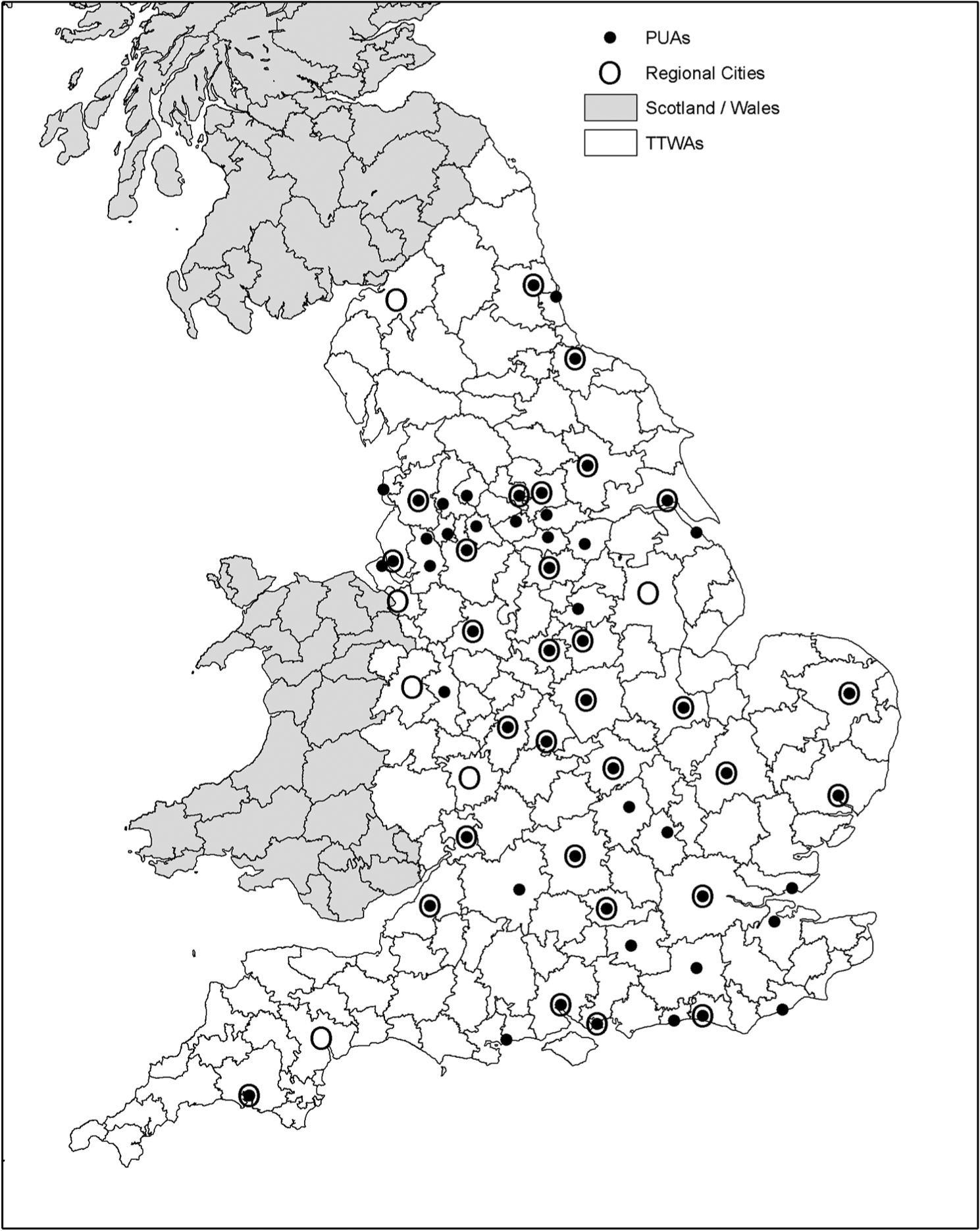
Travel-to-work areas and selected cities or large urban areas.
How then can these advantages of the TTWA method be utilised to define city-regions? What of the remaining challenge of moving beyond analyses of commuting data alone? Coombes (2000) created a procedure using the TTWA method to draw on diverse linkage patterns and it has had some policy-related applications (Shortt et al., 2005; PACEC, 2007) but they tend to show that it is too ‘black box’ (i.e. it is problematic to explain why boundaries were here not there). Another approach is needed to broaden the basis of region definitions beyond an exclusive focus on the labour market. It has already been argued that analysing migration data is the most appropriate first step beyond commuting data and this strategy is supported by the evidence from commuting and migration data in Catalonia where a parallel analysis of the two datasets revealed different patterns (Royuela and Vargas, 2009).
The migration dataset analysed here comes from the census in the same form as commuting data, making the TTWA method readily transferable. Migration flows are evidence of people trading one house for another and reveal housing market geography (Jones et al., 2012). Labour migrants who move to reach distant job opportunities are a small minority of all migration flows in comparison with people moving for housing or household reasons (Rossi, 1980; Gibbons and Machin, 2006). The latter move shorter distances, although some UK total migration datasets are dominated by students who often move a very long way: these temporary migrants have been removed here by excluding people aged under 25 from data covering Moving Group Reference Persons (MGRPs) as in Jones et al. (2012).
The strategy here is to identify potential city-regions as areas self-contained with respect to both commuting and migration flows. No existing method can analyse multiple datasets simultaneously but by sequential application of the TTWA method two housing market tiers were defined by Jones et al. (2012). Given that a set of city-regions must be robust labour market areas, definitions here can be built from TTWAs (Figure 2). The same requirement of at least two-thirds self-containment can be applied to the migration data, with the TTWAs grouped as indissoluble areas in the analyses because this prevents the commuting self-containment of any area declining. Also at this stage the minimum size threshold is set at an appropriate city-region level. This procedure defines city-regions based on the analysis of more than one flow dataset. Figure 3 shows the 39 areas defined in England on this basis, which ensures that

Potential city-regions and selected cities or large urban areas.
— all are at least two-thirds self-contained in terms of commuting; and also
— two-thirds self-contained in terms of migration by MGRPs aged 25(+); and in addition
— there are at least 100,000 households resident in each.
Figure 3 also shows the PUAs and the Regional Cities. Although the regions were not defined around central cities, no region in England does not house at least one PUA or Regional City. (Note that the northernmost area of England—Berwick—is grouped with Edinburgh, one of the Scottish Regional Cities.) Two of the regions include no PUA: they are in the peripheral areas where, as noted earlier, there are Regional Cities with relatively small populations in largely rural regions. These are cases where the ‘region first’ basis of the definitions was most valuable. Three regions have two Regional Cities and one has three Regional Cities: London is the focus of the latter extreme case. Figure 3 reveals a broad pattern of the more affluent south having larger regions than old industrial northern areas, due to longer commuting journeys and greater mobility reflecting higher prosperity (Axhausen, 2008). The smallest regions are often those with a PUA but not a Regional City: the political economy question in these cases is whether their city-regional governance would benefit from grouping them with larger neighbours that have the key characteristics of Regional Cities.
A minor issue for any English governance using these regions concerns the crossing of national borders. The four regions concerned all have English central cities and still meet the population minimum if limited to England. Berwick would become part of an English-centred region following a best-fit of these regions to whole LA areas for governance purposes. (It is likely that such a ‘best fit’ would leave some regions notably less self-contained.)
4. Review and Evaluation
This paper suggests that, in relation to sub-national governance in England in particular, the fundamentals of the city-region concept are unchanged from their initial specification by Geddes (1915). Their definitive features reflect the processes that create them—i.e. the development of modern economies and the associated increase in linkages between areas. Consequently all city-regions
— group together both urban and rural areas;
— have constituent areas linked by commuting flows, plus other flows;
— are fairly self-contained as local economies, if appropriately defined.
Although commuting data for over a 1000 areas in England have been available since the 1921 census, for decades there was no study to define city-regions robustly on this basis. Clearly to analyse a large flow dataset without computers would have been difficult, but the key reason may have been the lack of political will to reform sub-national governance geography. One result of the city-region concept remaining simply that—a concept—was that its contingent aspects as identified by Geddes (1915) were not examined empirically in England
— Do some city-regions have more than one city?
— Would a ‘regions first’ approach define better city-regions?
— Can a consistent set of city-regions include all parts of the country?
Starting in the 1960s, there have been intermittent periods when English sub-national governance was on the political agenda but the conceptual appeal of city-regions lost out to traditional resistance to radical change, with the latter fuelled by influential rural interests. Sceptics about the appropriateness of the city-region concept to England could point to the absence of a set of robustly defined boundaries that had wide acceptance (even though they would only provide one starting-point for discussions). Thus modern geographers had not met the aspirations of their predecessor Taylor (1942) who argued that the FEA—such as a city-region—is the most appropriate area for governance and indeed “we can delimit it on perfectly factual and realistic lines” (p. 63).
Among approaches to defining city-regions, the key dichotomy is between methods which adopt a ‘region first’ approach and those that initially identify central cities and then build regions around them. It was argued that, for the case of highly urbanised England in particular, definitions based on initial identification of cities depend heavily on the city selection criteria but as yet no straightforward criteria have consistently produced plausible results, especially if the units analysed are LAs and/or if the objective was complete coverage of the country. This drove previous city-based definitions to add complexities or inconsistencies to their methods, thereby undercutting the key attraction of city-based approaches which is their intuitive simplicity.
The empirical section of the paper ended by illustrating the alternative—‘regions first’—approach to city-region definition. This arguably did achieve a successfully comprehensive coverage of England, in part due to not looking first for central cities. This method was also technically innovative, drawing on two different flow datasets to meet the objective that city-regions are not reducible to labour market areas. In practice, all the 39 regions that met the requirements set (of population size and levels of self-containment of both commuting and migration) did include at least one noteworthy city. A corroboration of the ubiquity of cities in England is seen in the country having no region classified as ‘predominantly rural’ by the OECD (2010). Thus the empirical analysis found no ‘non-city-region’ in England but this was not guaranteed: the regions from such ‘regions first’ methods do not all necessarily include a city.
A detailed evaluation of the regions in Figure 3 is not relevant to the main purpose of this paper. It has proved possible not only to robustly define plausible city-regions in England but also to base these on migration flows as well as commuting data. Thus the concept outlined by Geddes (1915) can be implemented as boundaries portraying one aspect of the modern economic geography of England, indicating that technical obstacles need not prevent city-regions becoming key to sub-national governance in future. This is not to argue for taking the boundaries in Figure 3 ‘off the shelf’ as policy areas. Clearly, the principal obstacle remains the absence of political intention to instigate restructuring on that basis. In the event of a policy shift in that direction, there could also be a different preferred size of regions, for example. In that future scenario, the method illustrated here is one that can be adjusted so that the results met the new requirements (while also no doubt being applied to updated data). Figure 3 is therefore not put forward as ‘the’ answer but as ‘an’ answer. However, it is arguably the set of city-regions to implement most closely the fundamentals of the concept as it is interpreted in relation to the governance geography of England.
Footnotes
Acknowledgements
Map boundary data source: 2001 Census, Output Area Boundaries Crown copyright 2003. Census output is Crown copyright and is reproduced with the permission of the Controller of HMSO and the Queen’s Printer for Scotland. The particular migration dataset whose analysis has been reported here was specially created by the Office for National Statistics for a research study funded by the National Housing and Planning Advisory Unit (now closed down): grateful thanks are due to both organisations as well as colleagues on that project, especially project leader Colin Jones (Heriot-Watt University). Particular thanks are due to my Newcastle colleague Colin Wymer who carried out the analyses and produced the maps. The advice of referees is also gratefully acknowledged.