
Abstract
This paper explores the association between neighbourhood land use features and informal social control. More specifically, we examine the extent to which such features in combination with the socio-demographic context of the neighbourhood facilitate or impede collective efficacy and local civic actions. We achieve this through spatially integrating data from the census, topographic databases and a 2012 survey of 4132 residents from 148 neighbourhoods in Brisbane, Australia. The study creates a new classification of a neighbourhood’s physical environment by creating novel categories of land use features that depict social conduits, social holes and social wedges. Social conduits are features of the neighbourhood that facilitate interaction between individuals, social holes are land uses that create situations where there is no occupancy, and social wedges are features that carve up neighbourhoods. We find some evidence to suggest that residents’ reports of collective efficacy are higher in neighbourhoods with a greater density of social conduits. Density of social conduits is also positively associated with local civic action. However, in neighbourhoods with more greenspace, residents are less likely to engage in local civic actions.
Introduction
Resident-based informal social control is important for preventing unwanted behaviour, resolving community problems, and regulating crime (Bellair and Browning, 2010; Bursik and Grasmick, 1993; Warner, 2007). Well established in the literature is the relationship between neighbourhood socio-demographic characteristics and informal social control. Sampson and colleagues (Sampson et al., 1997) suggest that informal social control, or the willingness of residents to intervene in neighbourhood problems, is more likely when residents perceive their neighbourhood as socially cohesive, what they refer to as ‘collective efficacy’. Collective efficacy is higher in affluent, residentially stable and homogenous neighbourhoods, because these characteristics facilitate social interactions and the development of shared norms and values (Bursik and Grasmick, 1993; Sampson et al., 1997, 1999; Silver and Miller, 2004). Residents in affluent neighbourhoods also engage in informal social control actions more often than individuals living in disadvantaged and disorganised neighbourhoods (Wickes et al., 2017).
Given that land use arrangements can either facilitate or impede opportunities for encounters that foster social organisation (Hipp et al., 2014), it stands that a relationship also exists between neighbourhood land use features and informal social control. Scholarship indicates that land use influences the propensity for individuals to be co-present or indeed absent at particular places within their neighbourhood (Oldenburg, 1989). We also know that particular land uses can generate opportunities for both crime (Browning et al., 2010) as well as for place management (Wilcox et al., 2007). Qualitative case studies reveal that particular types of places within urban neighbourhoods (e.g. cafes and local shops) encourage social exchange and allow for the development of shared social norms (Lofland, 1998; Mehta, 2007, 2013). Drawing on these bodies of research we suggest that land use influences the capacity of residents to informally regulate against unwanted behaviour in their neighbourhood. Yet the role of neighbourhood land use arrangements in facilitating or impeding expectations for informal social control and the exercise of informal social control remains underexplored.
In this paper we build upon the previous literature that has focused on the influence of individual facilities or specific land uses on opportunities for the co-presence of offenders and guardians (for example, bars and parks, see Brantingham and Brantingham, 1995) by conceptualising neighbourhoods as comprising agglomerations of features and land uses with different propensities for facilitating and/or impeding informal social control (Wo, 2016). Following the work of Hipp and colleagues (2014), we classify land use features of the neighbourhood as social holes or social wedges whereby social holes are land uses that create situations where there is no occupancy, and social wedges are features that carve up neighbourhoods. Using two exemplar social holes, parks and industrial estates, and two exemplar social wedges, highways and rivers, Hipp and colleagues (2014) examined the association between the presence of these social barriers and place attachment. They found evidence that these land uses operate as barriers to social interaction necessary for the development of place based ties and attachment.
Here we introduce a third classification, social conduits, to account for the presence of features that create opportunities to foster the necessary pre-conditions for informal social control. While we argue that social holes and wedges represent spaces where social interaction is limited, our conceptualisation of social conduits represents neighbourhood land uses that encourage interaction between individuals. Social conduits range from traditional public spaces such as libraries and community clubs to ‘third places’ such as privately owned restaurants and cafes (Oldenburg, 1989). Currently there are no data that systemically capture the types and frequency of social interactions within places and across neighbourhoods. However, an established literature does suggest that particular social conduits inhibit the co-presence of local residents, whereas others promote social interaction (Felson and Boba, 2010; Hipp et al., 2014; Jacobs, 1961; Oldenburg, 1989; Wo, 2016).
As neighbourhood land use features differ in their capacity to generate co-presence, we identify functionally different land uses to examine their association with informal social control. Specifically we ask if neighbourhood social conduits, social holes and social wedges differentially explain the variation in residents’ perceived collective efficacy (encapsulating social cohesion and expectations for informal social control) and their engagement in local civic actions. The remainder of the paper is structured as follows: In the next section we first consider the literature on informal social control before drawing on scholarship investigating the role of neighbourhood land use features on crime and community functioning. We next describe the current study and data along with how we construct our measures of interest. This is followed by a presentation of the results derived from the regression models before closing with a discussion and a consideration of their implications in terms of how neighbourhood land use features combine with socio-demographic characteristics to influence informal community regulation.
The neighbourhood context of informal social control
In their influential work on the geography of crime and disorder across Chicago neighbourhoods, Shaw and McKay (1942) argued for the important role of resident-based informal social control – established mechanisms through which local residents could regulate and reinforce expectations for appropriate behaviour in the community. Social disorganisation and the later systemic reformulations of this theory consider that the informal social control of deviant or unwanted behaviour is only possible when neighbourhoods have ‘affiliational, interactional and community ties’ (Bursik, 1999: 86) through which residents can communicate behavioural expectations and organise collective action to respond to deviance.
Contemporary scholarship extends this idea and contends that while community ties may compliment the informal regulation of unwanted behaviour, they are ‘insufficient for the exercise of control’ (Sampson, 2002: 220, emphasis in original). Collective efficacy theory therefore focuses on shared values and expectations for intervention when residents observe norm breaking. From this perspective, when neighbours trust that fellow residents are willing to work together to prevent unwanted behaviour they are better able to regulate crime in their community. Thus, informal social control may be seen to represent the potential for intervention if residents observe crime or disorder. Many studies demonstrate that collective efficacy is related to lower rates of crime or a decreased risk of victimisation (Mazerolle et al., 2010; Morenoff et al., 2001; Sampson et al., 1997).
With the recent advances of collective efficacy scholarship, understanding the pre-conditions necessary to enhance informal social control has become a major focus of neighbourhood research. Studies have identified the social and demographic characteristics that either facilitate or impede the development of informal social control. In its original form social disorganisation theory highlights neighbourhood structural characteristics including disadvantage, ethnic diversity and residential instability as primary impediments to informal social control (Bursik and Grasmick, 1993; Kasarda and Janowitz, 1974; Kornhauser, 1978; Shaw and McKay, 1942). These socio-demographic characteristics remain strongly associated with collective efficacy (Sampson et al., 1997). Studies find that residential instability impedes the formation of the ties necessary for informal social control (Boggess and Hipp, 2010; McNulty, 2001; Peterson et al., 2000) while ethnic diversity makes communication between neighbours more difficult and hinders the formation of informal social control norms and expectations (Hipp, 2007; Peterson and Krivo, 2005; Warner and Rountree, 1997).
While neighbourhood characteristics are important for fostering collective efficacy, the primary, vital condition for informal social control is co-presence. Informal social control depends on encounters among neighbourhood residents (Browning et al., 2004; Bellair, 1997; Granovetter, 1973; Kasarda and Janowitz, 1974; Morenoff et al., 2001; Sampson et al., 1999), which in turn provide opportunities for information transmission, communication and observation of behavioural norms without the expectation of intense reciprocal exchange (Granovetter, 1973). The role of place-based ties also features in environmental criminology, where they are considered particularly important for influencing the attitudes, sentiments and actions of local residents, or what Taylor and others refer to as human territorial functioning (Taylor et al., 1984). Considering the centrality of local encounters between neighbours to both traditional and recent conceptualisations of informal social control, it is possible that in addition to neighbourhood demographic characteristics, neighbourhood land use features are likely to facilitate or impede informal social control.
Neighbourhood land use features: Places for mingling and lingering
Informal social control emerges from the actions and interactions of those who live, work, and otherwise visit a neighbourhood. Thus the extent to which neighbourhood land uses provides opportunities for interaction is likely an important consideration when examining inter-neighbourhood variation in informal social control. The spatial organisation of places significantly impacts the way people move through space and encounter others or pass by features by chance (Hillier, 2008). Differential patterns of land use result in some areas of the neighbourhood becoming more readily used than others. Some spatial patterns make it possible to avoid certain areas and act as barriers to chance encounters. Thus, the neighbourhood’s spatial configuration can shape social patterns. The layout of streets and sidewalks, the allocation of highly frequented land uses such as shops and the way they are all connected to each other within individual neighbourhoods and more broadly, the city, determine opportunities for chance encounters and social interaction (Jacobs, 1961). The spatial configuration of the neighbourhood may also generate conditions that enhance or inhibit crime (Felson and Boba, 2010). For example, routine activity theory argues that routine behaviours of offenders, victims, and guardians determine whether, where, and when crime occurs (Felson and Boba, 2010; Haberman and Ratcliffe, 2015).
Some land use features are designed to bring people together (Jacobs, 1961; Lofland, 1998; Lund, 2003; Oldenburg, 1989), a necessary pre-condition for informal social control. Traditional public spaces such as public malls and street markets and ‘third places’ such as restaurants and cafes are important everyday sites of informal, social interactions (Aelbrecht, 2016; Oldenburg, 1989). Thus, in neighbourhoods with greater densities of these physical features there is also greater potential for social interaction. For example, Lund (2003) found unplanned encounters with neighbours were significantly higher in neighbourhoods with local access to well-maintained shops and parks, compared with those lacking retail and recreational facilities. Ahlbrandt (1984) also demonstrates that greater use of local facilities in neighbourhoods (e.g. shopping, recreation, and worship) increases resident interaction. Thus, in addition to serving particular purposes – places for shopping and recreating – land use features that function as social conduits also provide opportunities to encounter others. Through these encounters individuals can learn social behaviours by observing how strangers behave, how their companions interact with strangers and how to behave themselves (Holland et al., 2007). This includes learning normative responses to rule infractions and expectations for informal social control action. However, other scholarship indicates that the interactions and social diversity stemming from mixed land use may impede the development of social cohesion and trust required for informal social control, as the presence of particular land use features provide anonymity for potential offenders and leads to the diffusion of place management responsibility across multiple stakeholders (Newman, 1972; Stark, 1987).
Other land use features create holes or wedges in the social fabric (Foster et al., 2013; Hipp et al., 2014; Mehta, 2007, 2013). Scholars demonstrate the propensity for both natural (e.g. rivers and forests) and human-made features (e.g. major roads and bridges) to place physical and social constraints on individuals by forming impermeable barriers to mobility (Brantingham and Brantingham, 2003; Clare et al., 2009; Felson, 2002), thus reducing opportunities for chance encounters with neighbours. A study in Australia found the presence of industrial estates, waterways and highways all negatively impacted social interaction (Hipp et al., 2014). Similarly, Grannis (1998) found that while ‘tertiary streets’ can encourage social interaction, larger streets serve as barriers to neighbourly contact.
Some land use features may either inhibit or promote co-presence. Greenspace represents a type of land use that may act as a social conduit or a social hole. Research shows that greenspaces are important for generating a sense of attachment to the neighbourhood (Hur et al., 2010; McCunn and Gifford, 2014), enhancing feelings of social cohesion (Mason, 2010) and providing spaces for social interaction (Coley et al., 1997; Kim and Kaplan, 2004). Yet other studies reveal that some greenspaces are perceived as risky and thus are avoided by legitimate users, creating social holes in the landscape (Cohen et al., 2016; McCord and Houser, 2015). This results in a lack of informal social control of these spaces, which in turn may explain why some greenspaces have high rates of crime (Crewe, 2001; Groff and McCord, 2012; Kimpton et al., 2016).
In summary, a growing body of research indicates that specific land use features may have consequences for social life. They may enhance opportunities for social exchange and feelings of responsibility, or they may create opportunities for crime or other social problems (Bernasco and Block, 2011; Browning et al., 2010; Kinney et al., 2008; Stucky and Ottensmann, 2009). What we do not understand is how these various land use features differentially influence the regulatory processes necessary for the prevention of crime and disorder. Our study therefore investigates the association between multiple types of land use features that facilitate or impede opportunities for neighbourhood informal social control. Here we examine the relationship between neighbourhood socio-demographics, social conduits, social holes and social wedges and residents’ collective efficacy. We also assess the association between these neighbourhood characteristics and residents’ local civic actions. The findings have implications for the way in which neighbourhoods are planned and (re)designed. Given the importance of informal social control for the regulation of neighbourhood crime and disorder, the built environment may prove a viable setting to improve community safety by invoking greater informal social control.
Study site
Our study context is Brisbane, Australia. Brisbane is the state capital of Queensland with a population of 2.06 million at the last census and a total area of 5950 km2 (ABS, 2011). Brisbane is one of the fastest growing areas in Australia with census noting an 11.5% increase in population between 2006 and 2011 (ABS, 2011). Brisbane comprises a total of 401 neighbourhoods. Brisbane has a monocentric urban form through which a major river divides the northern and southern areas of the city. There is no ring road that delineates inner and outer neighbourhoods. These neighbourhoods are connected by ferries, buses and trains that operate on a radial network. Brisbane neighbourhoods also vary in area and population. Population density is higher in central neighbourhoods and lower in those neighbourhoods on the city fringe (Figure 1). Like all cities, crime and community problems are not distributed evenly or randomly across Brisbane. While violence is relatively rare in areas located outside of key entertainment precincts, particular neighbourhoods experience higher levels of property crime and nuisance offences than others (QPS, 2015). Likewise, civic engagement varies across neighbourhoods. In the last census, 18.8% of Brisbane residents reported involvement in voluntary work. However, levels of volunteering varied considerably across neighbourhoods from 3% to 38% (ABS, 2011). Owing to this variability, coupled with recent population growth, Brisbane provides an interesting and unique site to examine predictors of residents’ reports of collective efficacy and their propensity to engage in local civic actions. While research has established the social structural predictors of informal social control, less well understood is the role of neighbourhood land use features in shaping opportunities for chance encounters, surveillance, the development of shared norms and intervention. Drawing on multiple data sources including the road network, the Digital Cadastral Database (DCDB) and Queensland Valuation and Sales (QVAS) data depicting land use classifications at the parcel level (e.g. parkland and industrial areas) we construct a unique classification of land use features (social conduits, social holes, and social wedges) that capture their different capacities to generate co-presence and in turn influence expectations for informal social control and local civic actions.

The case study area.
We spatially integrate administrative data with survey data from Wave 4 of the Australian Community Capacity Study (ACCS). The ACCS is a longitudinal survey of urban communities in Brisbane Australia that aims to understand the key social processes associated with the spatial variation of crime and disorder over time. Wave 4 of the ACCS was completed in 2012. Respondents (N = 4132 comprising 2528 longitudinal and 1676 top-up participants) comprised a randomly selected sample of individuals over the age of 18 years residing in one of 148 randomly selected suburbs in the Brisbane Statistical Division. The overall consent and completion rate was 46.27% (for further information see Mazerolle et al., 2012; Wickes et al., 2011). 1 This rate represents the number of interviews completed proportional to the number of in-scope contacts. Wave 4 of the ACCS comprises respondents from the previous three waves of the survey in addition to a top-up sample of respondents randomly selected in Wave 4. Owing to attrition in the longitudinal sample, a top-up sample is generated at each wave to retain ecometrically valid indicators of social processes. The 148 ACCS Brisbane suburbs comprise our total study sample.
Dependent variables
Using survey data from the ACCS, we examine the association between neighbourhood land use features and individual perceptions of collective efficacy. We also consider this relationship on the actions undertaken by residents in response to neighbourhood issues. We discuss each dependent variable in turn below.
Our first dependent variable captures an individual’s perceptions of social cohesion and trust and expectations for informal social control. We use exact measure employed in the Project for Human in Chicago Neighborhoods (see Sampson et al., 1997). Our measure of collective efficacy comprises a principal components factor score made up of nine items. Five items measure the expectations for informal social control. Participants were asked about the likelihood that their neighbours would intervene if (factor loadings are in parenthesis): children were skipping school (0.65); children were spray-painting graffiti on a local building (0.65); children were showing disrespect to an adult (0.52); a fight broke out in front of their house (0.46); the fire station close to their home was threatened by budget cuts (0.42). Four items measure perceptions of social cohesion, trust. Respondents were asked how strongly they agreed with the following statements (factor loadings are in parentheses): people in their neighbourhood were willing to help their neighbours (0.69); this is a tight knit community (0.76); people in this community can be trusted (0.69); people in this community do not share the same values (reverse coded) (0.41). 2 The scale items are the exact items used by Sampson et al. (1997) and derived from the Project on Human Development in Chicago Neighborhoods (PHDCN). Our measure of collective efficacy is a composite factor score of the nine items. This factor has an eigenvalue of 3.21. The null model revealed that 18.41% of the variation in individual perceptions of collective efficacy is between neighbourhoods.
The second outcome variable is local civic action. While our first dependent variable considers the contextual influence of the neighbourhood on perceptions, our second dependent variable examines its influence on actions undertaken local residents. This variable measures residents’ engagement in three types of activities directed towards resolving ubiquitous local issues that occur in many if not all urban neighbourhoods. Participants were asked if in the previous 12 months they had done any of the following: signed a petition; attended a public meeting; or joined with people to solve a local problem. Here we compute a summative score for each individual with scores ranging from 0 to 3. The null model revealed that 7.27% of the variation in an individual’s reported action is at the neighbourhood level.
Independent variables
Social conduits
Social conduits refer to land use classifications that facilitate interaction between individuals by encouraging pedestrian activity, loitering and the co-presence of individuals. These features may be expected to increase expectations for collective efficacy by facilitating the development of collective norms. They may also increase local civic actions by providing opportunities to supervise and intervene in observed problems. The following land use classifications are considered social conduits: recreational and entertainment facilities; shops; restaurants; hotels; taverns; cinemas/theatres; community clubs; sport clubs and facilities; educational facilities; religious features and libraries (Barton, 2000; Dempsey et al., 2011; Gordon et al., 2000; Winter and Farthing, 1997).
To assess the impact of social conduits on neighbourhood collective efficacy and local civic actions we compute a measure to capture social conduit density. Density of social conduits in the neighbourhood is computed as the proportion of total land parcels that are classified as social conduits.
Social holes
In this study we use the term social holes to refer to a broad range of land use classifications that create situations of non-occupancy by impeding pedestrian traffic and loitering (Hipp et al., 2014). Spatial structures that create situations where there is no natural spatial occupancy decrease chance encounters with fellow residents and provide opportunities for crime and disorder to occur without intervention (Browning et al., 2010; Hipp et al., 2014). As such we suggest that the presence of such characteristics may reduce the opportunities for chance encounters that help to establish norms of informal social control and actions. The following land use classifications are considered social holes: mine or quarry; cemetery; waste disposal; defence base; power station; warehouse and bulk store; oil depot; wharves; builders yard; industrial; community protection centre; transport terminal; reservoir/dam/bore.
As with social conduits, we compute the density of social holes in the neighbourhood. This variable is equal to the proportion of total land parcels in the neighbourhood that are classified as social holes.
Social wedges (fragmentation index)
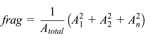
We suggest that in addition to the presence of particular land use classifications, the arrangement of urban spaces can also serve to either facilitate or impede the co-presence of individuals and in turn influence collective efficacy and local civic action. In particular, we suggest that street patterns can divide and connect urban space, thereby influencing ‘where residents can go and what they observe and interact with along the way’ (Southworth and Owens, 1993: 273). Social wedges include highways (streets with speed limits above 60 kph); railways and waterways. We propose that these features influence the propensity for social interaction by fragmenting the neighbourhood into a number of ‘patches’. To capture the degree to which residential and social spaces within the neighbourhood are fragmented by the presence of highways, railways and waterways we compute a fragmentation index. The fragmentation index measures the probability that two randomly selected points in the neighbourhood will be located in a single patch. A greater number of social wedges in a neighbourhood, reduces the probability that two points will be in a single patch. The probability is multiplied by the total size of the neighbourhood to convert it into a patch size. Lower values indicate fewer wedges while higher values indicate greater neighbourhood fragmentation. The fragmentation index was developed by Jaeger (2000) and is computed as:
where n is the number of patches,
Greenspace
Here we do not classify neighbourhood greenspace as either a social hole or a social conduit. Greenspaces cannot be easily placed in either category because the role and function of these spaces vary immensely (Kimpton et al., 2014). Some greenspaces such as those containing playground and picnic facilities may be expected to create opportunities for social interaction. Alternately, other greenspaces would be expected to act as a social hole. For this reason we control for the presence of greenspace and vacant urban land by including a variable that captures the percentage of the neighbourhood’s total area that is greenspace. To correct for right skew we take the natural log of this variable to use in the analyses.
Control variables
Individual level demographics
We included several measures to capture individual demographic characteristics. We included measures of age, gender (0 = male; 1 = female), marriage (0 = not married and 1 = married), and whether or not respondents had children (0 = no children; 1 = children). We also controlled for approximate household income in Australian dollars (1 = less than $20,000, 2 = $20,000 to $39,999, 3 = $40,000 to $59,999, 4 = $60,000 to $79,000, 5 = $80,000 to $99,999, 6 = $100,000 to $119,999, 7 = $120,000 to $149,999, 8 = $150,000 or more); 3 length of residence at the current address (1 = less than 6 months; 2 = 6 months to less than 12 months; 3 = 12 months to less than 2 years; 4 = 2 years to less than 5 years; 5 = 5 years to less than 10 years; 6 = 10 years to less than 20 years; 7 = 20 years or more), whether or not residents owned their house (0 = renter; 1 = home owner) and employment status (1 = employed; 2 = on a pension; 3 = not in the labour force; 4 = unemployed). 4
Neighbourhood structural characteristics
This study examines whether neighbourhood variations in residents’ perceived collective efficacy and local civic actions can be more comprehensively understood by simultaneously considering neighbourhood land use features that shape opportunities for chance encounters and neighbourhood socio-demographic characteristics. Well established in the literature is the association between neighbourhood disadvantage, ethnic diversity, residential instability and individuals’ perceptions of collective efficacy (Mazerolle et al., 2010; Sampson et al., 1997; Wickes et al., 2013). 5
Our measure of neighbourhood disadvantage is a principal components factor score comprising four variables drawn from the 2011 ABS census (factor loadings are in parentheses): percentage of neighbourhood households renting (0.806); percentage of lone-parent households (0.954), percentage low income households (0.871) and the percentage of neighbourhood residents who identified as Indigenous (0.888). The measure of disadvantage employed in all analyses is a composite factor score of these four measures. This factor has an eigenvalue of 3.11. In line with established research, we expect that residents in neighbourhoods with greater levels of disadvantage would report lower levels of collective efficacy and would report participation in fewer local civic actions.
Ethnic heterogeneity is captured using a measure of language diversity. In Australia, where the majority of immigrants come from Anglo-Saxon, English-speaking countries, language is a more meaningful indicator of diversity than country of birth (Wickes et al., 2013). To capture the amount of variation of language within each neighbourhood, we use the Blau index:
where p is the proportion of the total group who are members of a given category i. Values of the Blau index range between 0 and 1, with lower values representing homogeneity and higher values indicating heterogeneity (Blau, 1977). 6 We expect that residents in more diverse neighbourhoods would report lower levels of collective efficacy and local civic action.
We also included a measure of neighbourhood level residential instability. This is the percentage of residents in the neighbourhood who lived at a different address five years prior to the 2011 census. As instability has been shown to undermine the development of social ties and norms of intervention, we expected that greater residential instability would be associated with lower levels of collective efficacy and local civic actions. As a final control variable, we computed a measure of population density as the total number of persons per square kilometre.
Analytic strategy
Our aim was to assess the role of social conduits, social holes and social wedges in shaping variations in collective efficacy and local civic actions. After constructing variables to capture neighbourhood land use features we conducted mixed effects, multilevel regression analyses. We employed separate models predicting (1) residents’ perceived collective efficacy and (2) residents’ participation in local civic action. As our second dependent variable is measured as counts of local civic action, Model 2 employs ordered logistic regression with mixed effects. All analyses are conducted in Stata version 14.0. 7
Results
The final analytic sample comprised 4051 individuals residing in 148 Brisbane neighbourhoods. Table 1 summarises descriptive statistics and Table 2 presents correlations for each of the measures included in the regression analyses. The results of the mixed effects multilevel regression models are presented in Table 3. Model 1 of Table 3 examines the associations between social conduits, social holes and social wedges and perceptions of collective efficacy. Residents in neighbourhoods with greater densities of social conduits (β = 0.094, p < 0.05) perceived higher levels of collective efficacy. Other characteristics of the neighbourhood including, disadvantage (β = −0.265, p < 0.001) and ethnic diversity (β = −0.416, p < 0.05) were negatively associated with perceived collective efficacy. There was no relationship between social holes or wedges and perceived collective efficacy. Women (β = 0.181, p < 0.001), older residents (β = 0.003, p < 0.05) and residents with children (β = 0.094, p < 0.05) perceived greater collective efficacy than did men, younger residents and individuals without children, respectively. Homeowners also reported higher levels of collective efficacy than renters (β = 0.150, p < 0.01).
Summary statistics (n = 4050, N = 148).

Pairwise correlations.
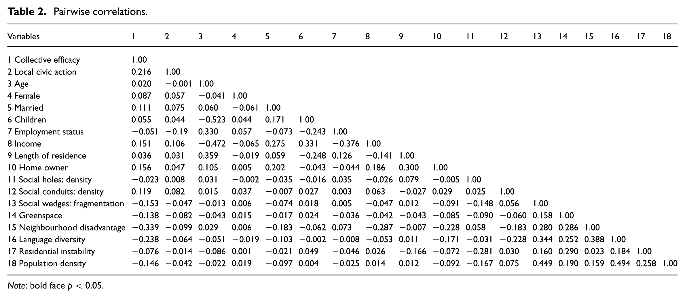
Note: bold face p < 0.05.
Multilevel regression (n = 4051, N = 148).

Notes: Significance: *p < 0.05, **p < 0.01, ***p < 0.001. Unstandardised coefficients ^average value across 10 imputed models.
Model 2 of Table 3 assesses the influence of neighbourhood land use features and socio-demographic characteristics on local civic action. There was a positive and significant relationship between the density of social conduits in the neighbourhood and residents’ participation in local civic action (OR = 1.271, p < 0.01). Alternately, residents living in neighbourhoods with more greenspace participated in fewer local civic actions (OR = 0.894, p < 0.05). This suggests that while neighbourhood land use features such as shops, sports clubs and schools may provide opportunities for participation in local civic action, greenspaces may act as social holes that limit community engagement. There was no association between the neighbourhood social holes or social wedges and reported local civic action. Women (OR = 1.316, p < 0.001), higher income earners (OR = 1.092, p < 0.05), and long-term residents (OR = 1.069, p < 0.05) participated in more actions than did men, younger residents, lower income earners and shorter-term residents. Residents with children also reported higher levels of local civic action (OR = 1.187, p < 0.05).
Discussion and conclusions
Collective efficacy theory proposes that expectations for informal social control develop in the context of social cohesion and trust and play an important role in community regulation and crime prevention (Bellair and Browning, 2010; Bursik and Grasmick, 1993; Warner, 2007;). Scholarship suggests that encounters between residents are important for collective efficacy and local actions (Wickes et al., 2017). In this paper we classified land use features as social conduits, social holes and social wedges based on their assumed capacity to facilitate or impede chance encounters in the neighbourhood to better understand the extent to which land use features influence collective efficacy and local civic action.
To date, scholarship has focussed on identifying the social and demographic characteristics that provide the necessary pre-conditions for the development of informal social control. Evidence suggests that affluent, socially cohesive and homogenous neighbourhoods have greater capacities for informal social control than their socially disorganised counterparts. An untested assumption in this literature is that resident co-presence in public places permit the observation of norms and actions to thwart unwanted behaviours (Steenbeek and Hipp, 2011). In this paper we asked whether greater densities of social conduits would be associated with higher perceived collective efficacy because these features have the potential to create local situations that facilitate encounters required for the development of norms of intervention. Indeed our results suggested this is the case. In neighbourhoods with greater density of social conduits, residents reported higher collective efficacy. Moreover the presence of social conduits also increased the likelihood that a resident engaged in local civic action in the preceding 12 months. When residents are spatially co-present in places that promote social interaction there is greater opportunity for surveillance and the performance of informal social control. As a consequence, residents are potentially more likely to develop a sense of territoriality and a sense of responsibility that motivates intervention (Newman, 1972; Taylor et al., 1984).
We also asked if the presence of social holes and social wedges decreased opportunities for co-presence and thus decreased collective efficacy and local civic actions. We did not find a significant relationship. However, we did find that the presence of neighbourhood greenspaces reduced the likelihood of local civic actions. Our data limits our ability to reveal whether this association is because greenspace acts as a social hole that impedes the willingness of residents to take informal social control action. Greenspaces vary widely in form and function, thus we argue future research is needed that explicitly examines how different types of greenspaces may differentially influence the informal regulation of crime and disorder.
Our study has added to the literature by revealing how neighbourhood land use features in combination with socio-demographic characteristics may influence informal social control. This is the first step towards an empirical understanding of neighbourhoods as dynamic entities and social processes as emergent properties contingent on both socio-demographic and neighbourhood land use features. Given access to longitudinal data we can extend our analytic framework to consider how informal social control develops as a function of changes in land use features (for example, the creation of a new park) over time. A further limitation of our study is the static classification of land use features and their link to a survey undertaken at a single point in time. The capacity to enumerate diurnal fluxes in urban populations is critical to fully understand the space–time constellation of local residents. However, there are no publicly available data to link these dynamic changes in resident populations to real-time survey data to examine local neighbourhood processes associated with crime control in situ. Development of smartphone-based survey and GPS-tracking methodologies would seem a promising emergent platform to examine these population dynamics.
Resident co-presence is a necessary pre-condition for the development of neighbourhood informal social control which in turn is critical for community wellbeing and the prevention of crime. In this paper we found that particular elements of the physical environment were important in predicting collective efficacy and the propensity of residents to take action in response to neighbourhood problems. Neighbourhood researchers, urban planners and policy makers must be mindful of the importance and role of the neighbourhood land use features that we conceptualised under three types; social conduits, social holes and social wedges when planning and (re)designing urban spaces. This is necessary to design urban environments that facilitate social interaction allowing residents to connect with one another and overcome many of the negative impacts of urbanism. Adopting this approach will ultimately help us to plan, build and organise cites in a manner that helps and does not hinder informal social control.
Footnotes
Declaration of conflicting interests
The author(s) declared no potential conflicts of interest with respect to the research, authorship, and/or publication of this article.
Funding
This research was funded by the Australian Government through the Australian Research Council Discovery project scheme, DP150101293.