
Abstract
Cities are increasingly central to sustainability discourse, as urban lifestyles and infrastructure are framed as solutions to global environmental problems such as climate change. This framing relies on geographically referenced visualisations such as architectural renderings, maps, and geospatial models, which portray environmental futures by envisioning the ‘sustainable city’. By showing what sustainability might look like in a future city, these geovisualisations strategically link urban planning interventions to global environmental policy debates. This process is explored through a case study of sustainability design proposed in Olympic cities. Aspiring Olympic hosts regularly adopt sustainability narratives of global–urban sustainability. In an effort to cast their events as ‘the most sustainable Games ever’, city leaders experiment with urban design (e.g. temporary stadiums, zero-carbon building design, or large-scale environmental restoration projects) and link them to global environmental debates. Visual analysis techniques are used to code architectural and geospatial images in 61 Olympic planning proposals, and to evaluate the use of visualisation practices in urban politics. While these designs are quite speculative, the visual artefacts produced through the planning process can be used as political tools for catalysing investment and projecting policy leadership.
Introduction
Urban planning and policy documents often include visualisations of a future city: glossy architectural renderings, carefully designed site plans, and geospatial products that map and model urban futures. Such visualisations play a notable role in sustainability planning, and in shaping global–urban sustainability politics (Wachsmuth and Angelo, 2018). By casting cities as laboratories for environmental policymaking (Bulkeley and Castán Broto, 2013; Evans et al., 2016) and linking the experiments to city-to-city policy networks (Acuto, 2013; Keiner and Kim, 2007; Rosenzweig et al., 2010), city leaders are able to design ‘sustainable city visions’ (Harris and Moore, 2015) with both local and global appeal. Yet while the vision may be appealing, the result rarely resembles the original proposal. In fact, these visualisations are highly speculative: partial uptake, substantial revision, or even outright abandonment are more likely outcomes.
Many such planning speculations will struggle to deliver. This is not a secret that needs to be discovered and deconstructed by critics; this is regularly acknowledged by project boosters themselves. So why do cities still invest time and money to design and visualise an urban future that may never be built? Why do urban leaders stake their careers on envisioning an urban future that is obviously speculative? Rather than simply critique its limitations, it is important to analyse what speculation actually accomplishes in urban politics. A growing cohort of scholars suggests that despite – or even because of – its speculative nature, urban visioning promotes and legitimates development agendas (Faulconbridge and Grubbauer, 2015; Holden et al., 2015; Leszczynski, 2016). Speculative design likewise helps shape and promote models of urban sustainability planning (Chang et al., 2016; Datta, 2015; Rapoport, 2014)
Speculative design enables strategic simplification in urban politics: visions of an urban future are intentionally designed to appear simpler than the current city. In this way nuance and complexity are exchanged for a targeted claims-making on the future city and its current resources. The stakeholders who promote these speculations – architects, construction firms, planners, local officials, real estate investors – may very well know that they are presenting an overly simplified vision of the city. Yet envisioning urban futures allows these actors to generalise their agendas, from implementing particular urban projects to making grander claims on global environmental politics. This instrumentalises sustainability, as environmental planning is leveraged for more mundane objectives such as advancing political careers, lobbying for funding, or marketing real estate. This also signals to a deeper layer of ideological practice, as the speculative nature of the design helps actors articulate rhetorical arguments about the future of the city. But this is not an argument about false consciousness: urbanists of all stripes are aware of the limitations of speculative design. This is also not an argument about cynicism, as urban leaders may be motivated by genuine concern for the environment. Rather this is an argument about the type of urban political work that can be accomplished through speculation, work such as catalysing real estate investment or projecting policy leadership.
This conceptual argument is illustrated with a case study of sustainability designs proposed in Olympic planning. This is a highly speculative urban planning exercise because of the competitive dynamics of Olympic bidding and contracting – cities may develop an Olympic plan only to see another city win the bid to host to the games. Sustainability plays an important role in mega-event planning, both as a way to articulate the benefits of the Olympics and as a political justification for making investments (Lauermann, 2014; Müller, 2015). When this speculative tendency is combined with an emphasis on sustainability, the Olympics tend to be portrayed as an opportunity to experiment with urban design and technology. Visual material is central to that experimentation: maps, aerial photographs, and digital products such as architectural renderings and geospatial models.
The paper begins by reviewing literature on the role of speculative design in urban politics, exploring it as a form of imitation, storytelling, and everyday practice. It then analyses strategic simplification in Olympic planning, using a visual content analysis of planning records. The paper examines four practices commonly used in Olympic planning: Visualisations of urban sustainability can erase unsustainable elements of the city from view, insert sustainable alternatives into the landscape, show ways of integrating interventions into the city, or model sustainability best practices. The paper concludes by evaluating the role of speculative designs as urban political tools. While the content of visualisations should be viewed through a critical lens, urban researchers should also consider the way in which images are used for political persuasion.
Speculative design in urban politics
Speculative design – visualisation of a future city through products such as blueprints, renderings, maps, and models – has long been part of the business of making cities. It is also a necessary component of sustainability planning, as a means to visualise environmental futures. The speculative nature of these products limits their impact, because of gaps between the ambitions of the vision and the constraints of actually existing cities. Yet the speculative element can also be an asset in urban politics. By showing an image of the future, planners can strategically frame the range of possible scenarios while leaving enough ambiguity to build coalitions of support. Speculative design can be mobilised in urban politics in three ways.
First, speculative design can be used as a form of aspirational imitation. This involves emulating success stories from elsewhere in the hope that the same design formula – the same building methods or technologies (Datta, 2015; Moser, 2012; Ren, 2011), the same iconic architecture (Ponzini, 2011; Sklair, 2006) – will produce similar development outcomes. These imitative practices rely on knowledge brokers who facilitate the mobility of policy models from one city to the next – in particular ‘starchitects’ (Knox, 2012; McNeill, 2009) and multi-national construction firms (Grubbauer, 2015; Rapoport, 2015). Such imitation ranges from ‘inter-city referencing’ (Roy and Ong, 2011) which builds on and may even subvert patterns from elsewhere to ‘geographies of serial seduction’ (Bunnell and Das, 2010) by which cities are persuaded to adopt homogenising visions of urban futures.
This type of imitation has been criticised for exerting a homogenising force on cities. There is a critical urban theory tradition which views imitative design as a consumerist ‘spectacle’ that puts profit over authenticity of place (Koch, 2012; Saunders, 2005). Likewise, there is a growing recognition that aesthetics can discipline urban space, especially when paired with entrepreneurial discourses such as that of the ‘world class’ city (Ghertner, 2015; Moser, 2012). Yet is important not to overestimate the top-down impact of these economistic influences. Imrie and Street (2009: 2509) suggest, for example, that urban design and its political economic regulation are ‘co-produced’, such that ‘the shape of the rules and their shaping of the practices of architecture, is part of a relational mixture of discursive practices and social and political processes’.
Second, speculative design can be used for ‘persuasive storytelling’ (Throgmorton, 1996) in urban planning. That is, visual products act not so much as literal blueprints, but as materials used in the rhetorical campaign which planners must wage in order to intervene in urban politics. The storytelling concept reflects a ‘communicative’ or ‘rhetorical’ turn in urban planning (Healey, 1996). This turn pays careful attention to the impact of discourse on planning outcomes, for example as stories are used in everyday planning practice (van Hulst, 2012) or as they are used to justify development ambitions (Holden et al., 2015). It is a call to acknowledge the inevitable messiness of planning (Sandercock, 2003). In this sense
planners should surrender any further pretense to the neutrality, objectivity, and universal Truth and Goodness that modernists hoped to find … They should, instead, embrace the idea that planning is scientific and political, technical and persuasive, and that the ‘tools’ planners use act as tropes (persuasive figures of speech) in the planning stories that they tell. (Throgmorton, 1996: 5)
At best, storytelling approaches acknowledge the incompleteness of planning. Cities will inevitably be messier than glossy renderings or smartly designed maps, but these tools can still be mobilised for the greater good. At worst, the storytelling becomes fictive or even disingenuous, as stories about the future are used to rally political support for vested interests through ‘corporate storytelling’ (Söderström et al., 2014) or to obscure project costs through ‘strategic misrepresentation’ (Flyvbjerg et al., 2002).
Third, speculative design can be thought of as an everyday practice, part of the ordinary work of making cities. Visualisations are also the artefacts with which city-making professionals – architects, planners, civil engineers, real estate developers – practice their trade. They are also a product, traded when selling a design to a city (e.g. by consultants) or when selling an agenda to constituents (e.g. when local officials promote plans). They are part of the knowledge that circulates through ‘transnational building practices’ (Faulconbridge and Grubbauer, 2015) mediated by property markets, the ‘construction’ of urban imaginaries (Salazar et al., 2017: 2) that combines mobile planning knowledge with local infrastructures and environments. The mundane facet of speculative design makes it politically malleable: the ways in which urban futures are invoked in planning documents and visualisations ‘tend to rely on a diffuse and extremely flexible series of iconic and historically grounded notions of cityness … [and] become merely a sort of automatic reference in contemporary, entrepreneurial and neo-liberal policy discourses’ (Vigar et al., 2005: 1406). As Easterling (2005: 3) argues, urban visualisation is bound up in the political economy of global industries less concerned with specific urban places than with the sale of generic design expertise: ‘The information it stores, as both data and persuasion, is literally a product, property, or currency’ and as a result it ‘may create territory that is at once strange and intimate, exposed and in disguise, real and fictional’.
Speculative design figures prominently in sustainability planning, whether as aspirational imitation, persuasive storytelling, everyday practice, or some combination of the three. The growing popularity of ‘urban age’ rhetoric (Brenner and Schmid, 2014) has brought cities to the forefront of environmental debates: rapid urbanisation amplifies the scale of urban environmental problems but also offers the promise of greener futures by shrinking per capita environmental footprints. While much of this urbanisation problematically expands the environmental footprint of urban infrastructures (Brenner, 2014), municipalities are also among the most motivated change agents in environmental policy (Barber, 2013). Sustainability initiatives stand out for the way in which they link urban scale interventions to global scale problems. With the increasing city-to-city mobility of urban sustainability knowledge (Keiner and Kim, 2007; Temenos and McCann, 2012) these designs also take on a multi-scalar dimension. They are not only envisioning sustainability in a future city (Harris and Moore, 2015; Rapoport, 2014), but in a future city can act as an urban laboratory or case study in best practice (Chang et al., 2016; Evans et al., 2016). In this way sustainability politics have taken on an ‘urban’ flavour, while certain cities have emerged as innovators through inter-urban diplomacy based on designing and exporting sustainability knowledge to other cities (Acuto, 2013; Bontenbal and van Lindert, 2009; Keiner and Kim, 2007). Much urban experimentation focuses on climate change, especially on themes such as resilience or lowering carbon footprints (Bulkeley and Castán Broto, 2013; Hodson and Marvin, 2010), and the role that cities play in multi-scalar networks of infrastructure and resource use (Guy et al., 2016).
Like many types of circulating policy expertise, these sustainability models and designs could be critiqued for promoting standardised, ‘silver bullet policies’ (Peck, 2011) that reflect the priorities of consultants (Vogelpohl, 2018) and urban elites (Smith et al., 2014) rather than local residents. For example, Harris and Moore (2015: 106) signal a ‘convergence of sustainable city visions through the domination of a few influential singular city “models”… e.g. eco-cities of Dongton and Masdar; livable cities of Vancouver and Melbourne; the creative cities of Barcelona and Portland’. ‘Vision’ here is meant as more than visual, including a discursive set of ideas, documents, materials, and practices. Nonetheless, speculative design is a useful tool for articulating, circulating, and standardising sustainable city visions. Indeed, Wachsmuth and Angelo (2018: 1043) argue that visualisation is a necessary component of articulating urban nature: discourses of urban nature are often ‘realistic illusions’, such that ‘if it looks green it is green. The self-evidently natural is assumed to in fact be natural, and moreover to be sustainable’.
Sustainability at the Olympics
Olympic host cities – and cities bidding to become hosts – regularly plan for urban sustainability (Gold and Gold, 2013; Mol, 2010). Olympic cities are promoted as laboratories for environmental policy, as city leaders use the event to experiment with low-impact architecture (e.g. temporary structures in cities such as London), low carbon management models (e.g. ‘carbon-minus’ models in Tokyo), and low impact buildings using both passive design techniques and ‘smart’ technologies (e.g. solar powered stadiums in Doha, a regular Olympic bidder and future World Cup host). There is a particular interest in designing environmental policy innovations that can be replicated internationally by future host cities (Lauermann, 2014), although rhetorical commitments to these policy models often fail to materialise in practice (Müller, 2015).
Visual products are an important tool for articulating sustainability initiatives. Through maps, models, renderings, and sketches, Olympic planners seek to persuade local stakeholders that the project will produce positive long-term legacy, and to persuade the sports industry that their cities will be effective stewards of a global brand. They are used to imitate perceived success stories, often in reference to paradigmatic models of best practice such as Barcelona (González, 2011), London (Müller, 2015), or Sydney (Cashman and Harris, 2012). Visualisations are also used for storytelling, as event planners justify their projects by promising a post-Games ‘legacy’ that will remake infrastructure and the built environment (Gold and Gold, 2013; Kassens-Noor, 2012). They reflect a shared aesthetic, promulgated by travelling experts and enforced by the International Olympic Committee’s technical guidelines. They are also an everyday Olympic planning practice, used to design and promote high-profile architecture and large infrastructure investments (Broudehoux, 2010; Muñoz, 2006). These practices play a supporting role in the urban politics of promoting the Olympic project. Seeing sustainability narratives is a significant step towards believing them, and ultimately towards investing in them.
The analysis that follows examines the techniques used to visualise sustainability in Olympic plans. The data are drawn from 22 years of cities’ bids to host the Olympics, starting with some of the first forays into sustainability planning by the Sydney 2000 organisers and continuing through bids for the 2022 Games (61 bids, dating 1993 to 2015). 1 A sample of images was collected from plans for ‘Olympic Villages’, the large housing complexes that host athletes during the Games. This sampling strategy was used because the villages tend to be the largest single land investment project in any Olympic plan and – as a neighbourhood-scale mixed-use development – contain the most diverse range of urban design challenges. The image sample primarily contains neighbourhood- and site-scale maps and architectural renderings, but also includes older techniques such as aerial photography, building drawings, dioramas, and hand-drawn sketches (n = 616 images).
These plans are by definition speculative. While bidding documents are the ‘official’ plan on which contracts are based, Olympic planning notoriously under-estimates costs while over-estimating benefits (Zimbalist, 2015). The majority of Olympic bids fail, but failed bids often still produce land use impacts by mobilising funding and producing plans which can be recycled into subsequent projects (Lauermann, 2016b). It is exactly this speculative dynamic that is of interest for the study: the goal is to assess how speculative design is used even though stakeholders know its limitations. Nonetheless, the gap between urban vision and urban reality present interpretive challenges, so the sample is triangulated with content analysis of post-Games reports published by host cites, technical manuals from the International Olympic Committee and mega-event planning firms, and local newspaper archives in the cities analysed (where available in English or French). The study is also informed by previous research on the mega-event planning industry, which included statistical analysis of land investment planning in 99 Olympic bids andin-depth interviews with 44 industry stakeholders and opponents (Lauermann, 2014, 2016a; Lauermann and Vogelpohl, 2017).
These data are analysed in order to identify the type of urban political work which can be accomplished when visualising sustainability. This is based on visual content analysis (Knowles and Sweetman, 2004; Rose, 2007), a method for systematically sampling and interpreting images. This is an established method among visual methods researchers, though recent work has expanded beyond analysis of static images by examining digital media (e.g. geo-tagged social media) (Lapenta, 2012) and by analysing how visualisations act not only as images but also as interactive interfaces (Dulic et al., 2016; Rose et al., 2014). Nonetheless this method is used because it allows analysis across a range of visual media and because the static images contained in Olympic archives are often the sole surviving copy of these visual products (especially in cities that bid for the Olympics but were ultimately unsuccessful).
The image sample was analysed using the qualitative analysis software QSR NVivo. Each image was classified as employing one of four types of simplification strategies: erasure, insertion, integration, and modelling. This theoretical typology was developed using an emergent coding scheme, and explains how an image visually simplifies urban complexity. This was based on the visual composition of the image, and thus was necessarily specific to each type of image (map, rendering, sketch, blueprint, etc.). It examined compositional elements including: the dominant visual components of each image (i.e. those in the foreground, or taking up the largest area), design strategies used for emphasis (e.g. visually striking hues, saturation, and contrast), and practices of inclusion and exclusion in the design (e.g. the kind of people or places that are included, or are left out). While compositional analysis was the primary tool in developing these theoretical codes, the images do not exist in isolation. Rather, they were originally presented as part of a broader plan. Thus the context of their presentation was also considered, by analysing accompanying text and contemporaneous rules and regulations in mega-event planning (e.g. Olympic planners emphasised different kinds of sustainability at different times, based on International Olympic Committee regulations at the time). This analysis used an exhaustive and exclusive coding strategy in order to achieve a replicable coding structure: all samples were coded, and each image received only one code (Rose, 2007: 64–68).
The theoretical codes were then cross-tabulated with the attributes of the plan from which each image was sampled, including characteristics of the Olympic Village site (owners, financiers, contractors, pre- and post-Games land use), and the sustainability design elements being visualised. These latter design elements include alternative technologies (especially renewable energy sources; 37 plans); passive design strategies (e.g. using natural heat and light, densifying construction to encourage walking; 23 plans); recycling systems (for wastewater and/or solid materials; 21 plans); green spaces, roofs, or walls (20 plans); use of locally sourced or recycled building materials (17 plans); and environmental restoration projects (often on post-industrial sites; 12 plans). The cross-tabulation was quantified to compare the simplification strategy used in each image with the attributes of the plan from which the image was sampled. Strong and weak associations between strategies and attributes were identified using Jaccard’s index of similarity, a metric that quantifies the strength of associations between variables in qualitative data sets (similar to how a correlation coefficient is used in statistical analysis). 2
Visualising sustainability
The visions presented in Olympic plans are highly speculative. Yet speculations continue to be made on large budgets, suggesting that they accomplish some sort of urban political work. That work involves intentionally and strategically simplifying urban environmental questions, as a way to link particular interventions in the city to more generally replicable models and best practices. Four simplification strategies stand out.
First, there is often a degree of erasure. This includes an erasure of the surrounding urban landscape when mapping the investment sites, and erasure of current land uses and users in other types of visualisations. This is a simple technique: elements of the current city are simply left off the page as a way to highlight plans for new development. This strategy is often used when a plan calls for wholesale redevelopment, for instance at a post-industrial site in need of environmental remediation. Usually the erased elements are simply left out with no explanation.
Olympic athlete villages are almost universally planned as new-build developments, with an average construction budget of US$596.2 million and an average area of 62.9 ha. 3 Their site histories are often vague, with the new village offered as a complete replacement for whatever preceded it: 35 of the 61 sampled plans do not discuss pre-Games land use at all, while another ten are post-industrial redevelopment projects involving complete demolition and new build construction. For example, Figure 1 is an architectural model of a housing development proposed for Manchester’s bid for the 2000 Olympics. The plan was based on an environmental strategy leading to ‘future sustainable urban development within a historic setting’ based on a series of planning stages, the first of which is ‘land clearance and reclamation’ (Manchester 2000, 1993: section 2.4). 4 Sustainability was to be achieved by clearing post-industrial land to make room for a new mixed-used development which the model visualises: pre-existing land uses and users are simply not discussed or seen in the design. This erasure strategy is repeated later in the plan, as the model is inserted into maps and an aerial photograph of the surrounding city.
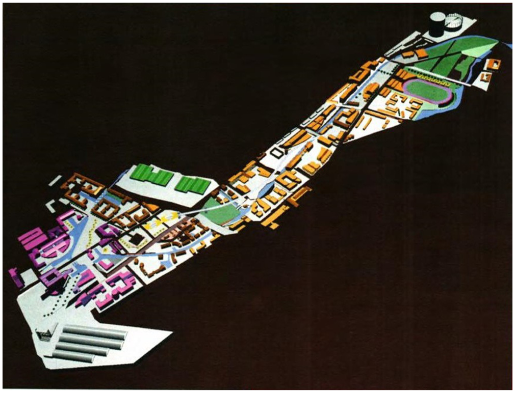
Erasing the landscape surrounding Manchester 2000 Olympic Village project CAD model.
Erasure can be used to catalyse real estate projects: by starting from a blank tableau, the planners can quickly demonstrate the potential for new construction. This kind of catalyst is a commonly cited goal of Olympic planners, as the planning process can provide an opportunity to build political coalitions and secure financing (Lauermann 2016b). Erasure leaves actually existing neighbourhoods off the map in order to foreground future investments, drawing those sites out of the landscape in order to lobby for funding or political support.
Second, alternative visions for the city are introduced visually through insertion. That is, an image of the city is altered to include a proposed project, visually fusing sustainable design elements into the current urban landscape. This technique is most directly applied through spatially referenced rendering, in which an architectural rendering is inserted into aerial photographs. As rendering software improves over the history of the sample it becomes increasingly difficult for a casual observer to distinguish between original photographs and inserted renderings. Insertion is a means of visually overwriting the city with new agendas, and potentially mobilising resources in the process.
Like erasure, insertion is associated with attempts to catalyse new construction projects by visually and discursively replacing existing land use and users, a practice observed in a number of recent Olympic cities (Gaffney, 2016). But unlike erasure it is more subtly persuasive: it merges elements from both original and new built environments. This often means inserting a project modelled after sustainable best practices, such as ‘an exemplary sustainable district’ (Paris 2008, 2000: vol. 2, p.217) or a ‘state of the art complex’ (Moscow 2012, 2004: vol.2, p. 197). It can also entail re-introducing nature into the city through wetland restoration (New York 2012, 2004), habitat restoration and the construction of artificial lakes (Sochi 2014, 2006), afforestation programmes (Cape Town 2004, 1996; PyeongChang 2018, 2010) or ‘the artificial creation of an ecosystem’ (Madrid 2012, 2004: vol. 2, p.199). For example, Figure 2 is a mashup of an architectural rendering and a photograph of the Chicago waterfront, as part of Chicago’s bid for the 2016 Olympics. This design starts with erasure, such that ‘development of this site will transform an underutilized and obsolete hospital campus into a new, vibrant neighborhood that will revitalize Chicago’s near South Side’ (Chicago 2016, 2008: vol. 2, p.187). But the visualisation then inserts a new waterfront neighbourhood into the foreground of the city’s skyline, showing elements such as pedestrian bridges and beachfront which ‘enhance connections for existing neighborhoods to the lakefront’ and which reflect the planners’ overall environmental strategy of a ‘Blue-Green Games’– sustainability in both land use and water resource management.
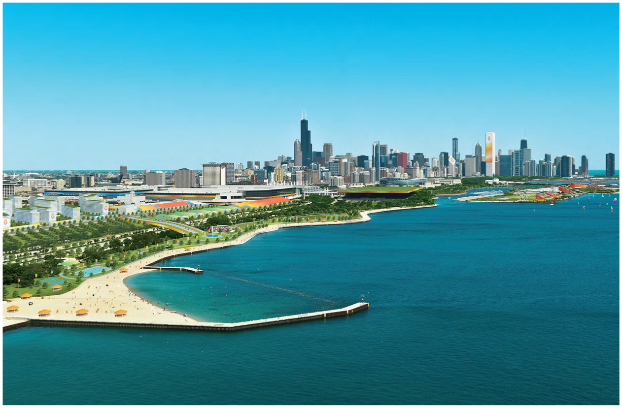
Inserting a Chicago 2016 Olympic Village Architectural rendering combined with photograph.
Third, images can show integration between the investment site and the broader urban fabric. Integration often includes insertion, but emphasises connectivity between the inserted project and the surrounding city. Intermingling of new and old are dominant visual themes, especially through network features (e.g. green corridors, expanded transportation networks). Some common visual indicators of connectivity are the inclusion of networks (e.g. public transit routes or pedestrian pathways) or other contextual information in maps (e.g. using detailed base maps). For example, Figure 3 is a site map for a housing development proposed for Paris’ bid for the 2008 Olympics. While the project’s goal was ‘a strategic conversion of a vast area of industrial wasteland’ (Paris 2008, 2000: vol. 2, p. 331), integration of the new-build project into the surrounding city was an important component. While the project involved large-scale demolition, the end goal was ‘the creation of a vast garden city within the urban landscape’ (bid for Paris 2008, 2000: vol. 2, p.337). Visually, this integration is shown with ample use of green spaces and corridors, and a base map that prominently displays existing infrastructure and buildings surrounding the site.
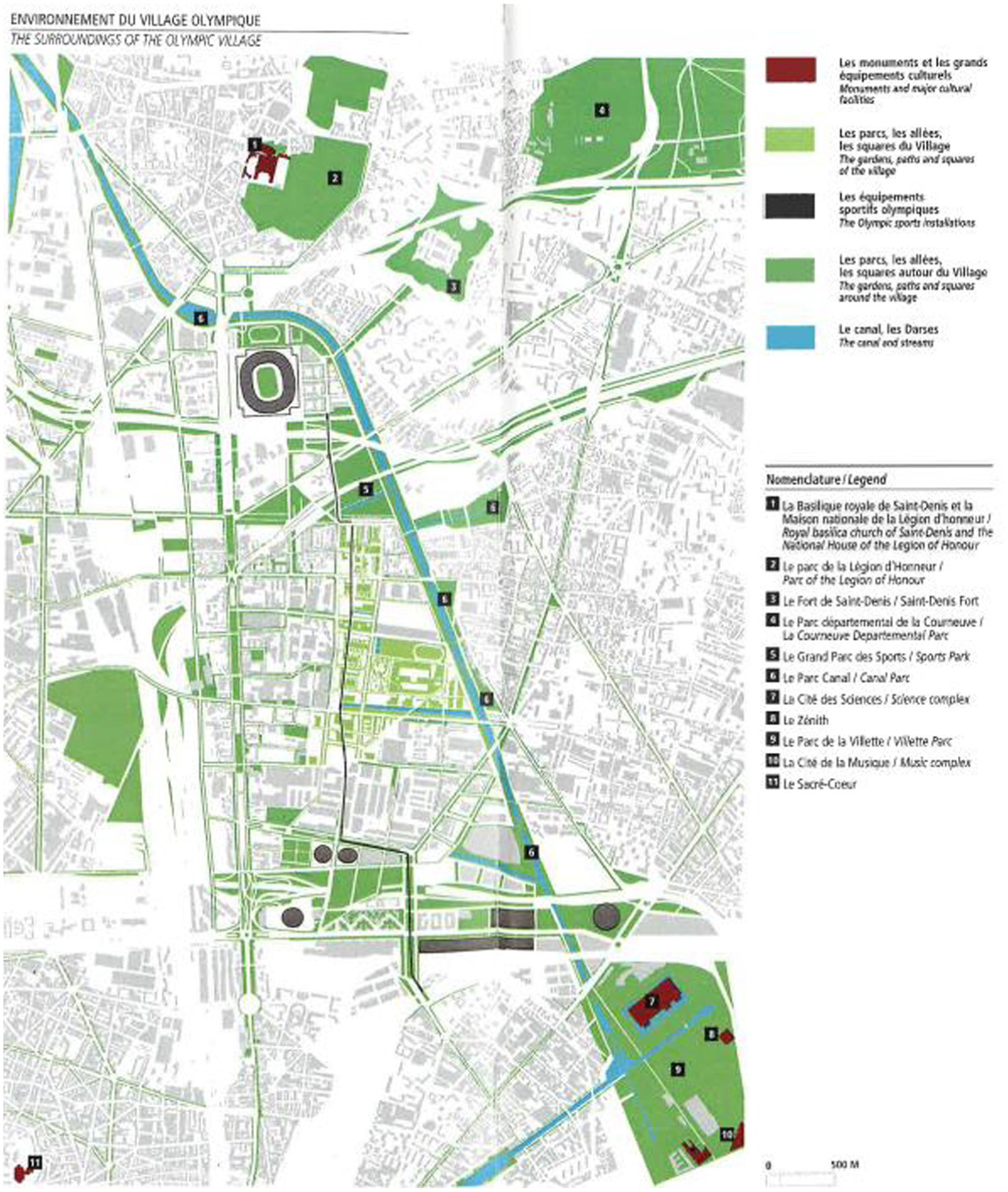
Integrating Paris 2008 installations into the urban fabric neighbourhood-scale map.
Integration is often used to portray investment projects as hubs for sustainability within a city. The idea is that connectivity between a very sustainable new project and a less sustainable urban landscape will increase a city’s average level of sustainability, often by lowering overall energy use or carbon emissions. This reflects a broader trend in mega-event planning toward densification and clustering as a sustainable spatial planning practice (Pitts and Liao, 2009). Early plans in the sample – especially plans for Winter Games – often split the Olympic Village across multiple sites and occasionally highlighted suburban design elements such as ‘low housing density, surrounded by a green belt’ (Jaca 2002, 1994: vol. 2, p. 26). However, plans in the latter part of the sample condense athlete housing to one site and emphasise energy savings obtained by densification, clustering, and walkability.
This technique allows Olympic plans to project leadership in environmental policy debates. Stakeholders involved in constructing, financing, or politically backing a sustainability hub can establish a local reputation for expertise or forward thinking. Those associated with Olympic planning success stories such as Barcelona (González, 2011), London (Müller, 2015), Sydney (Cashman and Harris, 2012), and Vancouver (Holden et al., 2008) have been able to internationalise that leadership through consulting and ‘policy tourism’ in which city officials travel to learn best practices (Lauermann, 2014). Sustainability has likewise become an important trope in Olympic urban politics, as local officials who claim forward thinking authority on the subject can mobilise their reputations in support of other non-Olympic projects (Davidson, 2013; McCann, 2013).
Finally, some of the most direct visualisations of sustainability offer models of best practice. These images are distinguished by an unusually large of number of sustainability elements contained within the same image, as a means of showing an ideal type built environment. This is seen most prominently in architectural renderings; those with a street-level perspective are particularly common for modelling. For example, Figure 4 is an architectural rendering of a housing development proposed for Tokyo’s 2016 Olympic bid; the project was later recycled into plans for the Tokyo 2020 Olympics. The proposed construction was to involve ‘leading edge environmental guidelines [that] will ensure that the Village becomes a new model for sustainable inner-city housing’ (Tokyo 2016, 2008: vol. 2, p. 195). These design features – green roofs, green walls, permeable pavement, etc. – are packed into the image as a way to showcase a variety of sustainable building techniques.
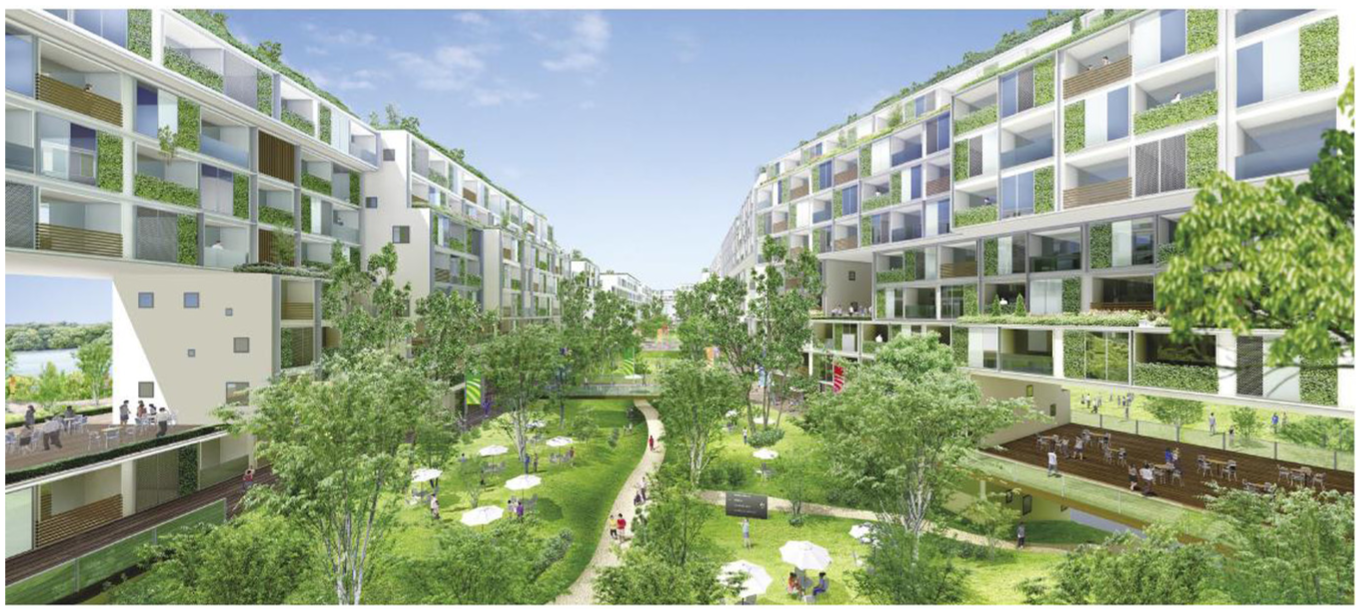
Modelling sustainable design elements for Tokyo 2016 Architectural rendering.
Modelling is another way for planners and sponsors to project leadership in environmental policy debates. In the image sample, the use of visualised models is correlated to narratives which promote Olympic cities as experimenters and innovators. Model images seek to demonstrate the feasibility or scalability of sustainable designs, and cast the city as a laboratory where sustainability can be tested and exported. The global replicability of sustainability designs is an enduring trope among Olympic bidders. Over the past several decades they have sought to design ‘an example of an ecological city’ (Jaca 2002, 1994: vol. 2, p. 28), a ‘new model of environmentally sustainable housing’ (Stockholm 2004, 1996: unpaginated), a ‘model … for the rest of the world in environmentally sustainable development’ (Beijing 2000, 1992: vol. 2, p. 359), ‘a model for environmental sustainability applicable to cities in both the developed and developing worlds’ (London 2012, 2005: vol. 1, p. 23), ‘the showcase of sustainability to the wider world’ (Tokyo 2016, 2008: vol. 2, p. 204), or ‘common guidelines … which can be measurable, operational, and reproducible to promote sustainable tourism’ (Annecy 2018, 2010: vol. 1, p. 16). The subtler implication is that local officials are able to claim a role as agents in experimentation and innovation. These images are an important currency in Olympic planners’ global–urban policy ambitions, a form of ‘policy boosterism’ (McCann, 2013) or ‘networked entrepreneurialism’ (Lauermann, 2014) that uses local policy innovation as a way to build international reputations as exemplars of best practice.
Visualisation as an urbanpolitical tool
Despite their speculative nature, visualisations of the future city play an important role in urban politics. They are a form of strategic simplification, repackaging complex urban problems into a neater, more politically potent format. Drawing on a study of sustainability planning in Olympic cities, this paper demonstrates that speculative visualisations are not literal blueprints for the future but are, rather, part of the rhetorical toolkit used by Olympic planning coalitions. This toolkit includes erasure of the urban fabric, which can then be overwritten through insertion of new visions for the same urban space. It also includes tools for showing integration between projects and the surrounding landscape by visually connecting the former into the latter, and for visualising a plausible urban future by modelling best practices. Collectively, these tools can help catalyse political support for investments and support planners’ efforts to project policy leadership by casting the city as an exemplar of environmental governance.
While speculative design is common across many fields of urban politics, it has taken on special significance in the politics of urban sustainability. Sustainability planning is oriented toward transforming an unsustainable present into a more sustainable future. With relatively few present-day examples to draw on, it must rely on visualisation to show what a sustainable city might look like. By linking visual representations of the city to futuristic exercises such as experimental architecture or new urban technologies, ‘sustainable city visions’ (Harris and Moore, 2015) can provide a politically persuasive fusion of the utopian and the actually existing city. In this way urban places can be portrayed as privileged sites of environmental governance, and urban officials who back the plans can be portrayed as leaders and experts. Through maps, models, and architectural renderings, cities do indeed look as if they can pioneer major environmental interventions.
These sustainable city visions are of course highly speculative, and they may never be delivered. Yet these speculations maintain their appeal because delivery is not the point. The point, rather, is to use planning tools to advance urban political strategies. Such visualisations show what kinds of urban future fall within the acceptable boundaries of urban politics. This general process has long been discussed in spatial theory – for instance by sociologist Henri Lefebvre (1974) as ‘representation of space’ or by geographer Don Mitchell (1993) as a ‘lie of the land’– based on the idea that representation of the landscape shapes our perceptions of who belongs in it. Visualisation allows city leaders and planners to offer what architect Keller Easterling (2005: 2) calls ‘spatial products’, master-planned projects ‘that index the world by marketing or scheduling protocols, thus presumably avoiding the political inconveniences of location’.
On the one hand, speculative design plays a mundane role in the everyday work of making cities. Maps, models, and renderings are the visual language of planning, and taking some creative licence is a necessary part of the trade. On the other hand, speculative design can instrumentalise sustainability. Critics in the urban studies literature often cite the idea of a ‘sustainability fix’, the application of green urbanism to resolve the contradictions and crises of local economies such that ‘active environmental policies and interventions such as river restoration, the cleaning up of old industrial sites, or “eco-investment” in public transport have been significant not only in reimagining cities, but have also been important in opening up actual urban spaces for new waves of investment’ (While et al., 2004: 550). Indeed, articulations of future sustainability have been linked to the marketing ambitions of entrepreneurial cities, operating as a ‘meme’ (Davidson and Gleeson, 2014), a ‘master signifier’ (Gunder and Hillier, 2009: chapter 8), or a ‘chain of equivalences’ (Davidson, 2010) connecting environmental intervention to economic development interests. The result is that the sustainable ideal is shaped by real estate ambitions (Rapoport, 2014), local boosterism (Müller, 2015; Temenos and McCann, 2012), and the interests of non-local institutions (Faulconbridge, 2013).
In this sense speculative design might be thought of as an ideological ‘category of practice’ (Wachsmuth, 2014), a representation of the city which is both ‘a representation of people’s relationship to urbanization processes’ and ‘a structured misrecognition that critical urban theory and practice must confront and seek to change alongside the sociomaterial forms that produce it’ (Wachsmuth, 2014: 87). That emptiness makes speculative design a useful tool in urban politics. There is a performative element here, in the sense that ‘ideological tropes do not endure simply because elite actors want them to’ (Wachsmuth, 2014: 88) but rather because their repeated invocation (and visualisation) structures the scope of political possibility. Critics would argue that this leads to a cynical engagement with sustainability: stakeholders know that their environmental plans are unlikely to succeed, but pursue them for more instrumental reasons such as bolstering political careers or lobbying for funding. Yet such ideological practices can also be understood as pragmatic or even altruistic: visualising an urban future is a meaningful step towards implementing it. The future city is certainly circumscribed by the ambitions of political actors in ways that might diverge significantly from the original sustainable vision. Yet repeated invocation of the sustainability city ideal mobilises resources while visualising the kind of city that political actors envision as possible.
Footnotes
Acknowledgements
This paper was originally written for a conference session on ‘Why does everyone think cities can save the planet?’ at the 2016 meeting of the Association of American Geographers, organised by Hillary Angelo and David Wachsmuth. The paper benefited from their subsequent guidance as guest editors of the eponymous special issue of Urban Studies. It also benefited from comments by Renee Tapp, Jayme Walenta, and Damian White. Thanks are also due to the Olympic Studies Centre and the LA84 Olympic Legacy Foundation for access to archives. All opinions and any errors are solely my own.
Funding
This research received no specific grant from any funding agency in the public, commercial, or not-for-profit sectors.