
Abstract
This study explores whether a relationship exists between sale prices and the presence of registered sex offenders in Jefferson County, Kentucky after accounting for observed and unobserved neighbourhood characteristics in accompaniment with property characteristics. The sale prices of single-family properties sold in 2015 were estimated as a function of the characteristics of the property, the housing and population characteristics of the neighbourhood, block group fixed effects and two separate measures of sex offender presence: a) the distance of the nearest registered sex offender to sold single-family properties; and b) the density of registered sex offenders within a half mile distance to sold single-family properties. Registered sex offender distance and density are associated with sale price when controlling for property characteristics and observed neighbourhood characteristics of the property, but these relationships cease to exist when unobserved neighbourhood characteristics are accounted for in the model.
Introduction
Extensive empirical evidence suggests that registered sex offenders (RSOs), prompted by sex offender legislation, have been pushed into neighbourhoods dominated by concentrated disadvantage, racial and/or ethnic heterogeneity and/or residential instability (Clark and Duwe, 2015; Hughes and Burchfield, 2008; Hughes and Kadleck, 2008; Mustaine and Tewksbury, 2011; Socia, 2012, 2016). However, these legislative efforts, such as a sex offender registry, community notification and residency restriction laws, have produced unintended consequences for the communities RSOs reside in, such as decreased home sale prices (Bian et al., 2013; Caudill et al., 2014; Larsen et al., 2003; Linden and Rockoff, 2008; Pope, 2008; Wentland et al., 2014; Yeh, 2015). Residency restrictions have especially encouraged social class discrimination concerning housing options for RSOs, who are more likely to reside in disadvantaged than in more affluent neighbourhoods (Clark and Duwe, 2015; Hughes and Burchfield, 2008; Hughes and Kadleck, 2008). Clusters of RSOs add to the adversity of already disadvantaged neighbourhoods as they are associated with additional degrees of structural disadvantage and threaten the neighbourhood’s social and economic landscape (Bian et al., 2013; Caudill et al., 2014; Clark and Duwe, 2015; Gordon, 2013; Hughes and Burchfield, 2008; Hughes and Kadleck, 2008; Mustaine and Tewksbury, 2011; Mustaine et al., 2006; Pope, 2008; Socia, 2016; Wentland et al., 2014).
The present study explores whether a spurious relationship exists, due to the unfavourable conditions surrounding the properties of RSOs, between RSOs and real estate property sale prices in an urban location. The omission of observable, objective housing and population characteristics, collectively referred to as neighbourhood characteristics hereafter, limits their power to influence the explained variance of the outcome – especially in a cross-sectional study – leading to imprecise coefficients that may misestimate the effect of RSOs on sale prices (Archer et al., 2010). For instance, potential spatial autocorrelation issues arising from sale price clustering of single-family properties are accounted for only by Caudill et al. (2014), who utilised a k-nearest neighbour sale prices matrix of rank three. Findings showed that when spatial effects are not accounted for, the effect of RSOs on sale prices is overestimated. Misspecification issues can also result from not including the degree of urbanicity of the explored setting into the model: Wentland et al. (2014) argued that the effect of RSOs on sale prices extended up to a mile because of the non-urban landscape of their housing data; however, rural and suburban single-family properties were not categorically distinguished from their urban counterparts. Estimation methods that exclude observable neighbourhood characteristics may yield an adverse effect on sale prices due to the presence of RSOs, with prior models including only neighbourhood fixed effects to control for unobservable neighbourhood characteristics on sale prices (Bian et al., 2013; Caudill et al., 2014; Pope, 2008; Wentland et al., 2014; Yeh, 2015).
The present study contributes to the existing literature by addressing these methodological limitations by accounting for the spatial structure of sale prices together with observed and unobserved or unmeasured neighbourhood characteristics, to explore whether RSO locational effects continue to dampen sale prices of neighbouring single-family properties in Jefferson County, Kentucky. Census block groups (rather than the commonly used census tracts in the sex offender literature) were used to proxy neighbourhoods in Jefferson County, Kentucky, as their smaller size results in more reliable localised estimates of the structural components within neighbourhoods (Clark and Duwe, 2015; Craun, 2010; Hughes and Burchfield, 2008; Hughes and Kadleck, 2008; Socia, 2012, 2016). Similar to results that have been found in past research, it is hypothesised that sold single-family properties financially react to the distance of the nearest RSOs and the density of RSOs (Bian et al., 2013; Caudill et al., 2014; Larsen et al., 2003; Linden and Rockoff, 2008; Pope, 2008; Wentland et al., 2014; Yeh, 2015). Our results initially support these hypotheses as both RSO distance and density variables are associated with property characteristics and observable neighbourhood characteristics. However, the addition of neighbourhood fixed effects negated the relationship between RSOs and sale prices.
Background
Sex offender legislation
The Jacob Wetterling Act of 1994 established the initial concept of sex offender registries, which were made publicly accessible following the enactment of Megan’s Law in 1996. Sex offender registries quickly became a tool for the public to exercise their privilege to be aware of the identities and residences of RSOs, and served as a foundation for residency restrictions (Sample and Kadleck, 2008). The fundamental notion of residency restrictions, adopted by at least 30 states, is that RSOs must legally reside a certain distance (which varies from 500 to 3000 feet) from venues (e.g. daycare centres, parks and schools) in which vulnerable populations (e.g. children) tend to congregate (Meloy et al., 2008). For example, the state of Kentucky maintains a residency restriction of 1000 feet that prohibits RSOs from residing near schools, playgrounds and daycare centres (KRS § 17.545). However, certain RSOs residing in Kentucky do not have to abide by the state’s residency restrictions, as these restrictions cannot be applied retroactively (Commonwealth v. Baker, 2009).
Sale prices
The earliest analyses of the effect of RSOs on sale prices of single-family properties were carried out by Larsen et al. (2003). The authors show that single-family properties in Montgomery County, Ohio within a tenth of a mile of more dangerous offenders suffer a greater reduction in their sale price (US$11,864) than do properties within a tenth of a mile of less dangerous offenders (US$4208). 1 In this particular context ‘dangerous’ is defined as RSOs who require proactive notification – as opposed to passive notification (i.e. community members deliberately seek information about RSOs) – whereby the sheriff’s office notifies neighbouring homeowners and school officials within 72 hours of the RSO establishing residence in the neighbourhood. Later studies present mixed results regarding the effect of more dangerous – usually classified as at high risk of sexual recidivism – versus less dangerous RSOs on sale prices, with the requirements for classifying RSOs into dangerous and less dangerous categories varying by study (Pope, 2008; Wentland et al., 2014; Yeh, 2015). Likely contributing to these inconsistent associations between RSOs and decreased sale prices are how jurisdictions vary in their classification of RSOs (by risk level for example) or possibly that the public view RSOs as a homogeneous group of criminals, thus, it is aimless to explore whether properties reacted differently via sale prices when near different types of RSOs (Levenson et al., 2007).
Linden and Rockoff (2008) use time-series panel data of sale prices – incorporating the move-in dates of RSOs – for single-family properties sold during a 10-year period in Mecklenburg County, North Carolina. Their findings show that within the two-year period following the arrival of an RSO, sold properties within one-tenth of a mile decrease in price by roughly four percent (US$5500, based on the median sale price of sold properties in the study). The most considerable financial loss – an 11.6% reduction in sale price – was exhibited by single-family properties directly adjacent to the properties of RSOs.
Similar to Linden and Rockoff (2008), Pope (2008) does not find any evidence of a price association beyond a tenth of a mile of an RSO’s residence in his study of single-family properties sold from October 1996 to April 2006 in Hillsborough County, Florida. Pope (2008) continues the theme that a sold single-family property within a tenth of a mile of an RSO is negatively affected, with an average reduction in sale price of US$3500. Pope’s (2008) work also establishes a marked causal link between RSOs and sale prices, as sale prices rebounded once RSOs departed from their residential location. A similar phenomenon was later reported by both Wentland et al. (2014) (in central Virginia) and Yeh (2015) (in Lancaster County, Nebraska).
Wentland et al. (2014) suggest that selection bias may be present when modelling only sold properties. By incorporating a Heckman selection model and accounting for all single-family properties on the market in central Virginia, Wentland and his colleagues (2014) demonstrate that the reduction in sale prices associated with RSO presence is also apparent at further distances, particularly intensified by the non-urban landscape of their housing data. Sold and unsold single-family properties that were within one mile of an RSO exhibited a reduction of US$3488 in the sale price, on average, relative to sold and unsold single-family properties located more than a mile from an RSO. Using the same dataset as Wentland et al. (2014), Bian et al. (2013) demonstrate that clusters of RSOs – in this case, the presence of four RSOs within a of a quarter mile – result in a larger decrease in sale prices (US$25,099) than a single RSO (US$8338).
Caudill et al. (2014) are the first among these scholars to control for the spatial structure of single-family properties in neighbourhoods to ascertain whether RSOs continued to be associated with sale prices. They incorporate a spatial component – the weighted sale prices of the three nearest sold single-family properties – in their model that contains single-family properties sold from 2008 to 2012 in Shelby County, Tennessee. Their hedonic spatial error model shows that the sale prices of properties within one-tenth of a mile and within one mile from the nearest RSO decrease by 14% and 7.4%, respectively.
Even after accounting for the spatial structure of residential properties, Yeh (2015) finds among her sample of high-risk RSOs (classified by risk assessments) greater decreases in sale prices of residential properties near high-risk RSOs classified as non-transient (i.e. at the same residence six months or longer) than of those near transient RSOs. Relative to transient RSOs who were associated with smaller reductions in sale prices, non-transient RSOs resided in neighbourhoods characterised by lower proportions of Whites, owner-occupied housing units, college graduates and residential stability (defined as homeowners in the same household for five years), otherwise unfavourable neighbourhood characteristics. These results suggest the role that housing and population characteristics of neighbourhoods may have when estimating their effects alongside RSOs on sale prices, as RSOs tend to reside in neighbourhoods with greater proportions of unfavourable housing and population characteristics (Clark and Duwe, 2015; Craun, 2010; Gordon, 2013; Hughes and Burchfield, 2008; Hughes and Kadleck, 2008; Mustaine et al., 2006; Socia, 2012, 2016; Yeh, 2015).
Housing and population characteristics of neighbourhoods
Accounting for those characteristics that describe the housing and population within the neighbourhoods in which single-family properties have sold may help to eliminate any spurious outcomes in the relationship between sale prices and RSO residence. One such confounding variable is the proportion of Blacks living in the neighbourhood, as increasing Black populations are negatively associated with housing values and positively associated with the numbers of RSOs in the neighbourhood (Burnell, 1988; Craun, 2010; Hughes and Burchfield, 2008; Hughes and Kadleck, 2008; Mustaine et al., 2006). When the sex offender literature considers housing and population characteristics as independent features, scholars have consistently found that neighbourhoods with RSOs exhibit lower proportions of college graduates and children under the age of 18 and higher proportions of vacancies (Clark and Duwe, 2015; Gordon, 2013; Hughes and Burchfield, 2008; Hughes and Kadleck, 2008; Mustaine et al., 2006; Socia, 2012, 2016; Yeh, 2015). These are the housing and population characteristics within neighbourhoods that may (negatively) affect sale prices, independent of the effect of the RSOs who reside in them.
Data
Jefferson County, Kentucky – located along the Ohio River across from Indiana – is coterminous with the city of Louisville and the largest county in Kentucky. In 2015, this merged city-county was home to 763,509 residents spread across 380.42 square miles, with a population density of approximately or 2007.02 persons per square mile (US Bureau of the Census, 2018b). Aside from being denser in population, Jefferson County is unique from those settings used in prior studies exploring the effects of RSOs on sale prices because it is known that roughly one-in-four homeowners within the county are aware of RSOs adjacent to their properties; in other words, homeowners’ awareness may affect the relationship between sale prices and nearby RSOs (Beck and Travis, 2006; Bian et al., 2013; Caudill et al., 2014; Larsen et al., 2003; Linden and Rockoff, 2008; Pope, 2008; Wentland et al., 2014; Yeh, 2015). This study relies on data from four sources: the Jefferson County Property Valuation Administrator’s office, Kentucky’s sex offender registry, the US Bureau of the Census’s 2010–2014 American Community Survey 5-year estimates and the 2010 US Bureau of the Census Summary File 1.
Dependent variable: Sale prices of single-family properties
With the use of spatial software, this article explored the relationship between RSOs and sale prices of single-family properties in an urban location, controlling for property characteristics, housing and population characteristics of neighbourhoods and neighbourhood fixed effects. The dependent variable is the sale price of single-family properties sold in 2015 in Jefferson County, Kentucky. Sale prices for 19,373 residential parcels were acquired as a shapefile from the Jefferson County Property Valuation Administrator office through a data use agreement with the Louisville and Jefferson County Information Consortium (LOJIC). Single-family properties were chosen as the unit of analysis to correspond with the previous literature that explored the relationship between sale prices and the presence of RSOs (Bian et al., 2013; Caudill et al., 2014; Larsen et al., 2003; Linden and Rockoff, 2008; Pope, 2008; Wentland et al., 2014; Yeh, 2015). Parcels that were empty lots, outbuildings or developed through Low-Income Housing Tax Credit were removed from the analysis (n = 1139). Residential properties sold below the 1st percentile in the sample, including those with a sale price of US$ 0, were unlikely to have been subjected to typical market forces and were excluded from the analysis (n = 1034) (see Linden and Rockoff, 2008; Pope, 2008; Yeh, 2015). An additional 79 parcels were missing one or more of the explanatory variables used in the model and so were excluded from the sample. Descriptive statistics (Table 1) indicate that single-family properties in the sample had a mean sale price of US$179,063, with prices ranging from US$7580 to US$4,400,000. Due to its skewed distribution, the dependent variable was normalised via the natural log function.
Descriptive statistics of all variables (N = 17,121).
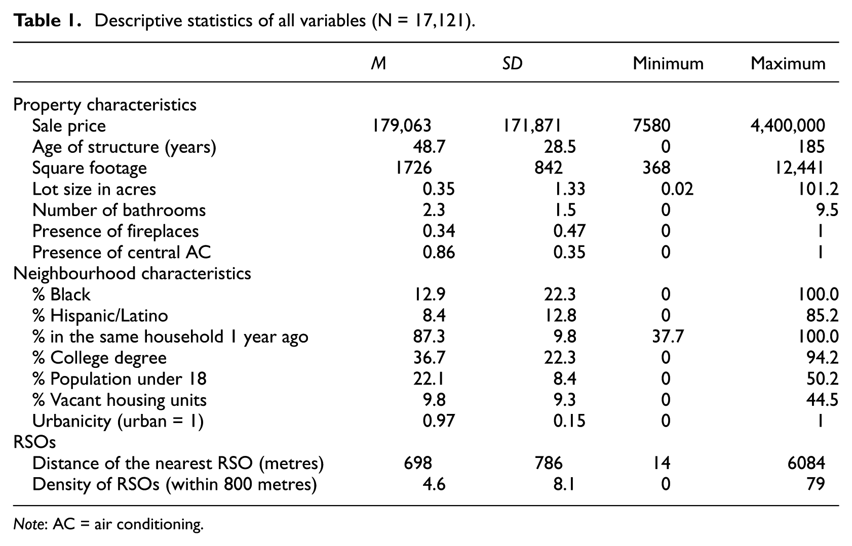
Note: AC = air conditioning.
Primary independent variable: Registered sex offenders
According to the Kentucky sex offender registry, a total of 1289 individuals convicted of registerable sex offenses resided in Jefferson County, Kentucky as of 1 February 2016. As is standard practice in the sex offender literature, RSOs with invalid addresses (e.g. homelessness, incarceration; n=69) and non-compliant statuses (e.g. failure to register, failure to notify legal authorities about an address change; n = 77) were removed from the dataset (Clark and Duwe, 2015; Mustaine and Tewksbury, 2011; Mustaine et al., 2006). The remaining records were geocoded, with a successful address match rate of 99%; the final data included 1143 RSOs. This geocoding match rate exceeds the conventionally accepted match rate of 90% for accurate mapping suggested by Bichler and Balchak (2007). Spatial software was used to calculate the distance from each sold property to the nearest RSO as well as the number of RSOs residing within an 800-metre buffer around each sold property. The latter measure is designed to capture the density of RSOs, given the wealth of empirical evidence that shows that clusters of RSOs are deleterious to communities (Bian et al., 2013; Clark and Duwe, 2015; Gordon, 2013; Hughes and Kadleck, 2008; Mustaine and Tewksbury, 2011; Mustaine et al., 2006; Socia, 2016).
Control variables
Property characteristics
Six characteristics of the sold properties were used as control variables in modelling the sale price. The age of the property, the total living area of the property (or square footage), the size of the parcel and the number of bathrooms were included as continuous variables. The presence of at least one fireplace and the presence of central air conditioning (AC) are represented as dummy variables.
Neighbourhood characteristics
Seven housing and population variables characterising the neighbourhood proxied by census block groups were included to account for the structural effects of place on the sale price: a) the % of the population that is Black; b) the % of the population that is of Hispanic/Latino origin; c) the % of the population that has been in their current household for a year or more; d) the % of the population aged 25 or over with at least a Bachelor’s degree; e) the % of the population that is under the age of 18; f) the % of housing units that are vacant; and g) the urbanicity of the block group. The degree of urbanicity operates along a spectrum, with values ranging from 0 (entirely rural) to 1 (entirely urban), and is calculated by dividing the total number of housing units located in urbanised areas/clusters from the total number of housing units in the census block group. The choice of these variables was based on theoretical linkages and the previous sex offender literature, with an effort to limit the amount of collinearity between the selected variables. In addition to the inclusion of the noted neighbourhood variables, neighbourhood fixed effects are incorporated into the model to account for the unobserved heterogeneity between block groups.
Model specification and data analyses
Descriptive analyses were conducted in SPSS, with all OLS and spatial regression models carried out using GeoDa and R. The OLS assumption of independent errors is violated by the presence of spatial autocorrelation in a regression model framework (Anselin et al., 2000). Spatial autocorrelation will result in biased standard error estimates, and consequently, erroneous statistical inferences (Anselin, 2005). A preliminary OLS model for the sample detailed above suggested that spatial autocorrelation was present in the residuals – the residuals were clustered in space, with a Moran’s I value of 0.22 (p < 0.001).
Anselin (2005) provides two potential methods for dealing with spatially autocorrelated residuals: the spatial lag model and the spatial error model. A spatial lag specification is appropriate if the sale prices influence one another via diffusion. However, a spatial error specification is more appropriate when variables in the model do not accurately capture the underlying spatial process generating the data.
Anselin (2005) provides a testing procedure for identifying which of the two spatial model specifications is more suitable for a given set of data. Results for these Lagrange Multiplier and robust Lagrange Multiplier tests indicated that a spatial error model was the better specification, as it resulted in larger log likelihood values and lower Akaike Information Criterion and Bayesian Information Criterion (Schwarz criterion) values than the spatial lag model. All models thus incorporate a spatial error term, as well as a weighting scheme based on distance. Consistent with the distances utilised by Larsen et al. (2003) and Wentland et al. (2014), a distance weighting scheme with a threshold distance of 800 metres was adopted to explore and analyse the spatial processes present in the data. In this weighting setup, single-family properties sold within 800 metres of a given property exert influence on the sale price of that property, while properties more than 800 metres from a given property did not exert influence on the given property.
Results
The top panel of Table 2 shows spatial error regression coefficients from the regression of sale price on the distance of the nearest RSO. Model 1 includes controls for property characteristics only. Model 2 adds controls for the population and housing characteristics of the neighbourhood, and Model 3 adds neighbourhood fixed effects.
Coefficients from spatial error regression models of sale prices (ln) on RSO presence, property characteristics and neighbourhood characteristics (N = 17,121).

Note: AC = air conditioning.
Of primary interest in these results is the distance of the nearest RSO coefficient, which is statistically significant in Model 1 (b = 0.0615, p < 0.001) and Model 2 (b = 0.0547, p < 0.001), but not in Model 3. The statistically significant coefficients in Models 1 and 2 for the RSO distance variable are positive, indicating that sale prices increase as the distance from the nearest RSO increases. The interpretation of coefficients from a spatial error model is the same as the interpretation of coefficients from a non-spatial OLS model (LeSage and Pace, 2009). Because the dependent variable is log transformed, the exponentiated regression coefficient is interpreted as the change in the ratio of the expected geometric means of the study’s variables. Thus, a 1000-metre increase in the distance between a sold single-family property in Jefferson County and the residence of the nearest RSO is associated with a 5.6% increase in the sale price, after controlling for property and neighbourhood characteristics (Model 2). Notably, this relationship is no longer apparent once neighbourhood fixed effects are incorporated into the final model (Model 3).
Coefficients for property characteristics of sold single-family properties in Model 3 are all statistically significant (p < 0.001) and consistent with theoretical expectations. Of the six property characteristics, only the age of the property is associated with a decreased sale price in Jefferson County. The remaining five property characteristics – square footage, acreage, number of bathrooms and the presence of fireplaces and central AC – are associated with an increase in sale price.
Model 3 also demonstrates that the sale prices of single-family properties are partly influenced by the observable neighbourhood characteristics of the properties. Higher proportions of Blacks (b = −0.0079, p < 0.01) and vacant housing units (b = −0.0649, p < 0.01) are both associated with reduced sale prices, whereas a higher proportion of college degree holders in a neighbourhood is associated with increased sale prices (b = 0.0240, p < 0.001). Surprisingly, greater residential stability is also associated with a reduced sale price (b = −0.0367, p < 0.001). The degree of urbanicity and the proportions of Hispanics/Latinos and persons under the age of 18 have no statistically significant effect on the sale prices of single-family properties located in the neighbourhoods of Jefferson County. The statistically significant spatial error term suggests that accounting for the spatial structure of the data is important in this model estimation; that is, the other variables in the model did not fully account for the spatial correlation of the error term in an OLS model.
The bottom panel of Table 2 displays the results from the regression of sale price on RSO density. Similar to the findings detailed above, the density of RSOs is statistically significant in Model 1 (b = −0.0058, p < 0.001), which controls only for characteristics of the sold property, and Model 2 (b = −0.0092, p < 0.001), which adds controls for neighbourhood characteristics. The negative sign on the RSO density variable indicates that each additional RSO within an 800-metre radius of a sold single-family property reduces the sale price by 0.9%, after controlling for property and neighbourhood characteristics (Model 2). Again, however, the inclusion of neighbourhood fixed effects renders the RSO density variable non-significant (Model 3). Coefficients for all property and neighbourhood characteristics in Model 3 are nearly identical to those from the corresponding RSO distance equation. This is an unsurprising outcome because the RSO distance and density variables – although only modestly correlated (ρ =−0.35) based on a Pearson correlation coefficient – are highly correlated (ρ=−0.83) based on a rank correlation coefficient.
Discussion
This study contributes to the sex offender and housing literature by showing that – once neighbourhood heterogeneity and spatial autocorrelation have been addressed – the presence of RSOs is not spatially associated with decreased sale prices in Jefferson County, Kentucky. Similar scholarship that relied on property characteristics as controls without controlling for observable and unobservable neighbourhood characteristics and/or considering spatial effects may have misattributed or overstated the effect of the presence of RSOs on sale prices (Bian et al., 2013; Caudill et al., 2014; Larsen et al., 2003; Linden and Rockoff, 2008; Pope, 2008; Wentland et al., 2014; Yeh, 2015). When controlling just for property characteristics, the present study finds that increases in the distance of the nearest RSO (and density of RSOs) are positively (negatively) related to sale prices. The present study also finds that the inclusion of housing and population characteristics that characterise neighbourhoods affects sale prices but changes neither the direction nor the magnitude of these RSO correlations. However, the inclusion of neighbourhood fixed effects renders both the RSO distance and density variables unrelated with sale prices; yet, neighbourhood fixed effects do not affect the property characteristic coefficients, and exhibit only a moderate effect on the coefficients for neighbourhood characteristics. The importance of neighbourhood fixed effects thus becomes a central question in interpreting these results.
Theoretically, neighbourhood fixed effects were included in the model to control for the unobserved or unmeasured characteristics of the neighbourhood which were not appropriately controlled with the other included variables. For example, in the absence of neighbourhood fixed effects, any variation in sale price that might occur due to the presence of a neighbourhood watch programme – a characteristic that may well be known by the homebuyer and thus factored into the price offered – is encompassed either within the coefficients for other variables or the error term in the model. Once the neighbourhood fixed effects are included, the variation in sale prices that might occur due to the presence of a neighbourhood watch programme is encompassed within the neighbourhood fixed effects, rather than the other coefficients. The fact that the inclusion of neighbourhood fixed effects has little effect on the coefficients for any variable except the RSO distance or density suggests that these unobserved characteristics of the neighbourhood are uncorrelated – or at least not strongly correlated – with our observable neighbourhood characteristics, but are correlated (at some magnitude) with the RSO variables. While this theoretical examination sheds light on the process that is happening within the model estimation, it does not offer any guidance as to precisely what unobserved aspects the neighbourhood fixed effects are incorporating. The example of the neighbourhood watch programme was used because this is one possible explanation for the results shown in our models, although there is no evidence that it is the explanation. Other idiosyncratic features, such as the visible police presence in the community, might also affect sale prices, while simultaneously being affected by the distances of the nearest RSOs and/or density of RSOs.
Some neighbourhood characteristics are more important predictors of sale prices than other neighbourhood characteristics based on the magnitudes of the coefficients. In particular, the proportion of neighbourhood vacancies shows a strong relationship with sale prices, with each percentage point increase in vacant housing units associated with a more than six percent decrease in the prices of single-family properties sold in that neighbourhood. In contrast, a strong predictor of increased sale prices was residential instability in neighbourhoods. Although this result is unexpected, it is possibly the result of new housing constructions, sales in previously unoccupied neighbourhoods, gentrification and/or house flipping; flipping schemes are common in neighbourhoods that contain larger proportions of Blacks, like Jefferson County (Anacker, 2009; US Bureau of the Census, 2018a). Although the estimated relationships between the sale price of single-family properties and the percent of Blacks and percent of college-educated in the neighbourhood are consistent with Burnell’s (1988) and Yeh’s (2015) findings, the non-relationship between the sale price and the neighbourhood Hispanic/Latino population is somewhat surprising. It is also surprising that no significant relationship between sale price and the percent of children under the age of 18 exists, given that previous scholarship found that the value of family households (proxied by the number of bedrooms) nearby RSOs decreased at exceptionally high values (Bian et al., 2013; Wentland et al., 2014; Yeh, 2015).
Although the non-significant relationship between the presence of RSOs and sale price found in this study could be the result of the particular methodological approach, there may be alternative explanations for this finding. Notably, a hypothesised relationship between sale prices and RSOs relies on the assumption that residents are aware of local RSOs, and that the known presence of RSOs induces fear and ultimately decreases sale prices. The unique findings of the present study might thus be attributed to the modest awareness rate of RSOs by homeowners in Jefferson County, Kentucky (Beck and Travis, 2006). Another possibility is that the present study’s sample of RSOs may have included an above average proportion of transients (resided at the listed registry residence for six months or less), and therefore may have been less influential on sale prices (Yeh, 2015). It may also be the case that because RSOs already reside in neighbourhoods characterised as disadvantaged and with lower sale prices, these communities have become tolerant or apathetic regarding the local presence of RSOs (Clark and Duwe, 2015; Hughes and Burchfield, 2008; Hughes and Kadleck, 2008; Mustaine and Tewksbury, 2011; Socia, 2012, 2016).
Limitations and future research
The current models are not directly comparable to other studies that also assessed the relationship between RSOs and sale prices. For instance, concentric circles were considered but not created for two principal reasons. First, it is illogical given that the public is mostly unaware of local RSOs (Beck and Travis, 2006; Craun, 2010). Second, concentric circles are made up of arbitrary lengths (of tenths or quarters of a mile) that are neither theoretically nor empirically supported, and even if they were, not all RSOs in Kentucky are subjected to residency restrictions, or legally abide by them, in general, as they are transient in nature given their legal status (Commonwealth v. Baker, 2009; Socia, 2012).
Other limitations noted are to assist considerations for future scholarship. For example, we were unable to obtain move-in and move-out dates for RSOs in the sample, and thus are unable to measure transience of the RSO population. If such data became available in the future, its inclusion in a time-series framework could be used to establish a stronger temporal causative argument between RSOs and sale prices (Pope, 2008). Only relevant (albeit limited) property characteristics were considered in the present study, though this decision was related to the study’s objectives, which focused on neighbourhood effects. Future research should dive deeper into which unobserved characteristics of neighbourhoods (as the results suggest) create mediating or moderating effects between the sale prices of single-family households and the presence of RSOs. Hierarchical linear modelling methodologies should be pursued to exploit level-2 or level-3 characteristics. For instance, Craun’s (2010) hierarchical linear modelling analysis found that higher proportions of Hispanics/Latinos in urban neighbourhoods predicted a lower awareness of nearby RSOs. Relatedly, the exact mechanism through how Hispanic/Latino neighbourhood populations affect sale prices in urban neighbourhoods warrants further research. The non-relationship observed in the present study might be due to this ethnic population not hitting a high enough threshold to constitute a threat to homeowners. The present study also relied on a spatial error modelling strategy in an effort to be comparative to prior studies that included spatial modelling. However, additional spatial modelling specifications such as the spatial Durbin model include spatially lagged independent and dependent variables, and might better represent the real estate processes that are occurring within urban neighbourhoods (LeSage and Pace, 2009).
Conclusion
The present study explores how neighbourhood characteristics and neighbourhood fixed effects within a spatial analytical context might affect the previously observed relationship between the sale price of single-family properties and the presence of RSOs. This is the first study to incorporate observable and unobservable neighbourhood characteristics into a spatial modelling framework to mitigate the risk of misestimating the effect of the presence of RSOs on sale prices. Our results suggest that the presence of RSOs is confounded with characteristics of social disorganisation in the community and that unobservable differences between neighbourhoods might be responsible for the assumed link between housing price and RSOs.
Footnotes
Declaration of conflicting interests
The author(s) declared no potential conflicts of interest with respect to the research, authorship, and/or publication of this article.
Funding
The author(s) received no financial support for the research, authorship, and/or publication of this article.