



Abstract
In many developing countries, urban growth is characterised by the emergence of informal housing at the periphery. Nevertheless, there is little evidence based on data from informal land markets and, in general, studies focusing on such markets often neglect environmental factors. Therefore, to contribute to these research gaps, this article aims to enhance our understanding of land markets in informal land parcels and their relationship to environmental amenities, by providing empirical evidence from Mexico City. The article estimates a hedonic pricing model using robust ordinary least squares with a SHAC (Spatial Heteroskedasticity and Autocorrelation Consistent) inference, including structural, environmental, neighbourhood and accessibility features. Results provide empirical insights regarding the way this land market behaves in the peri-urban area. Our findings reveal that informal land parcel purchasers are willing to pay for basic services such as access to piped water, proximity to schools and accessibility features such as being close to city centre, motorways and underground stations. Although a positive relationship between land price and distance to the nearest forest or Protected Natural Area is highlighted, it is low, meaning that individuals are largely ambivalent about environmental amenities. Therefore, the problem of irregular settlements could be approached from two different angles. Firstly, informal land buyers will not desist from invading and modifying natural areas without a comprehensive urban and environmental policy, oriented towards changing the perception of green areas as potential urbanisation opportunities. Secondly, public policy needs to solve the housing supply crisis, considering the characteristics presented here.
Introduction
In many developing countries, urban growth is characterised by the emergence of informal settlements at the periphery (Hardoy and Satterthwaite, 2014; Wigle, 2010). In 2014, approximately 883 million people lived in such settlements in developing regions (United Nations, 2018), and for Latin America and the Caribbean the estimated population was about 105 million, almost 21% of the total population (United Nations-Habitat, 2016).
This rapid urbanisation has outstripped the capacity of local governments and private housing markets to plan and provide land for housing, especially for low-income people. This, in turn, encourages the creation of informal land markets. This phenomenon can be explained by continued rural–urban immigration, growing demand for living space in urban areas, elevated conditions of poverty and land use deregulations (Crane et al., 1997; Das et al., 2017).
The land market is not elastic, and it can be either formal or informal, or a mix of both (Birch et al., 2016). The formal market is based on national or local laws and government regulations on either land rights or specific zoning. Otherwise, people can obtain land through informal instruments such as informal purchase, illegal occupation, inheritance, donation, among others (Twarabamenye and Nyandwi, 2012). In the case of informal land sales, their cross-elasticity of demand is low since no substitutes exist. Yet, these kinds of settlements are managed by actors who have some weight in the real estate market. Therefore, any assessment of urban housing markets in developing countries should also consider the informal sector to avoid misleading estimates (Jimenez, 1982). It is important to note that the behaviour and effectiveness of the market depend on the context, the local history of informal settlements and the political regimes of each country. Hence, it is necessary to conduct empirical research worldwide (Zhang and Zhao, 2018).
In this regard, two main categories of informal settlements have been distinguished (Durand-Lasserve and Selod, 2009: 106). The first category includes unauthorised commercial land developments – frequently built on private land – where land is parcelled illegally, mostly by informal developers, and sold out as parcels. The illegal character of the subdivision must be highlighted, which arises either due to a violation of zoning and planning regulations, or because the obligatory permit for land subdivision has not been granted. When the land is illegally occupied, against the will of the landowner, it refers to the second type: squatter settlements on public or private land. In this article, the latter will not explicitly be discussed, as we focus mainly on unauthorised commercial land developments. An additional interest in this case study is that several unauthorised commercial transactions are carried out in a declared ecological area in the south of Mexico City.
Urban informality is common in peri-urban areas (Allen et al., 2006; Cohen, 2006) and frequently has environmental impacts (Benítez et al., 2012; Zeilhofer and Topanotti, 2008). Some authors (Ravetz et al., 2013: 16) point out that the dominant urban form might be precisely the peri-urban one, and that consequently it is the most important urban spatial planning challenge of the 21st century. However, most research presents and analyses the land access crisis and contemporary environmental problems separately.
Local values such as neighbourhood features, public goods, location-specific facilities and environmental amenities are capitalised in land values (Cheshire and Sheppard, 2004). Therefore, hedonic pricing models (HPMs) have been used for decades, mostly in developed countries, to provide useful information about the willingness to pay for different characteristics and amenities. Nevertheless, to the best of our knowledge, there are few studies on informal markets in informal land parcels in environmental areas (Everett, 2001; Moschella, 2018). Previous studies have focused mainly on slum and squat dwellers in developing countries, under the concern of land tenure and property rights. In India, Nakamura (2017) applied a spatial hedonic model to study how slum residents appraise formalised land. In Peru, Hawley et al. (2018) carried out an assessment of how squatting and property rights affect monthly rental values. Zhang and Zhao (2018) analysed how informal institutions affect the pricing mechanism in the Chinese informal housing market. In the 1980s, another concern was to estimate the demand for housing characteristics in countries such as Korea, the Philippines, Colombia and El Salvador (Follain and Jimenez, 1985; Follain et al., 1980; Lim et al., 1984; Quigley, 1982). However, environmental amenities have often been neglected. Some authors (Arimah, 1992; Crane et al., 1997) have estimated hedonic models in developing countries including environmental amenities, although they have focused mostly on infrastructure conditions (such as waste disposal, water supply, neighbourhood roads) rather than ecological assets. Das et al. (2017) showed slum occupants’ preferences in India, including variables related to a clean environment, but they did not consider green areas. An HPM in Chile measured the influence of a green area in slums, but the variable was not statistically significant (Espinoza and Balaguer, 2009).
In Mexico, as in many other Latin American countries, the bulk of urban housing production corresponds to irregular settlements (Connolly, 2009). The main reason is that access to housing for a high percentage of the population is only possible through informal settlement means, due to low income or to not meeting the requirements for mortgage credit or legal rental contracts (Connolly and Wigle, 2017). In this study, we only consider Mexico City proper (CDMX), not Greater Mexico City which also comprises municipalities surrounding Mexico City.
As the informal land market and environmental values trade-off is a challenge that needs attention, this article aims to enhance our understanding of land markets of informal land parcels and their relationship to environmental amenities, by providing empirical evidence from Mexico City as a case study. Therefore, this article addresses the following research questions: which characteristics determine the land value under a land market in informal parcels in a restricted environmental area in theperi-urban area of Mexico City? Does the value of environmental amenities play a role in such a market?
The outline of the article is as follows. The next section presents the basic features of the Mexican context. In the third section, the methodology is given, followed by the estimated results and a discussion of the findings. Finally, some policy implications are offered.
The institutional context in Mexico
From 1900 to 1970, Mexico City’s population increased rapidly, from 0.7 million inhabitants in 1900 to 6.9 million in 1970. By 2015, the population accounted for 8.9 million inhabitants (7.5% of the country’s total), of whom 99.5% were urban and 0.5% were rural (Instituto Nacional de Estadística y Geografía (INEGI), 2015).
The city is comprised of 16 districts. Four of these constitute the central city. The remaining 12 surround this core and have boundaries with other federal provinces. Districts with natural areas (i.e. Conservation Land, CL) are shown in Figure 1: Cuajimalpa de Morelos, Álvaro Obregón, La Magdalena Contreras, Tlalpan, Xochimilco, Milpa Alta and Tláhuac. From 1970 to 1980, the population of the central city decreased, while the surrounding districts presented an accelerated growth. Although the rate of growth has diminished in the last decades, it is still higher (12%) than in the central city (3%) (INEGI, 2015).

Study area.
With population growth, urban expansion gradually spread into the countryside without following a development plan, and thus many irregular settlements appeared. For example, from 2003 to 2007, 5300 ha of CL were lost, corresponding to a rate of about 1300 ha per year (Aguilar and Santos, 2011). Besides this, about 867 irregular settlements have been registered in almost 2800 ha (Aguilar, 2008, 2016).
In fact, urban sprawl into conservation areas has been facilitated by the nature of the Mexican land property regime. Rural and peri-urban land can be private or social (communal or ejidal) (Jones and Pisa, 2000). The Mexican ejido is a land tenure system that resulted from the Mexican Revolution of 1910. Article 27 of the 1917 Mexican Constitution guaranteed land to the landless (ejidal land) and restored land to the indigenous communities (communal land). Thus, a given community is the owner of their corresponding land, while each individual has a given parcel of land with the right to work on it (Vázquez-Castillo, 2004). Ejidos and rural communities were legally blocked from selling their land. However, a Constitutional amendment in 1992 allowed them to sell their land, accelerating the urbanisation process throughout the country (Aguilar and Santos, 2011).
Changes in the legal framework have been implemented since the 1970s in an attempt to hinder urban sprawl. Hence, in 1978, the Urban Development Plan of Mexico City divided the city in two categories, urban and non-urban, this latter with two zones: a Buffer Zone or transitional area between urban and rural spaces; and a Preservation Zone, which in 1987 was classified as Conservation Land (Aguilar, 2008). CL covers about 59% (88,442 ha) of Mexico City’s territory and is defined as an area that should be preserved since it offers multiple ecosystem services (PAOT and SEDEMA, 2012). Nevertheless, despite being listed as a conservation area, it has many human settlements within its boundaries, in particular traditional towns (ejidos and communities) that used to be dedicated to agricultural activities (Aguilar, 2008).
Figure 1 shows in green the area of the original CL polygon. It is not a completely forested area – there are large areas with forest cover and several transition zones corresponding to different forest, agricultural and cultural uses, in addition to urban recognised areas – but urban developments are not authorised here (GDF, 2000).
It is important to highlight that only 9.3% of the CL is considered a Protected Natural Area (PNA), under the jurisdiction of the local Ministry of the Environment (SEDEMA).
Methods
Background to hedonic pricing modelling
One of the most widely used tools for evaluating the economic consequences of public policies is the hedonic pricing model (HPM), particularly where the supply of environmental amenities is concerned (Kuminoff et al., 2010). This revealed preference method of valuation relies on information provided by individuals when they make decisions in real markets to assess household preferences. The fundamental hypothesis is that complex goods (e.g. houses or parcels) are a combination of attributes. Consequently, the total price is composed of the elementary prices of each of the characteristics (Rosen, 1974).
In general, researchers take real market transactions and from these data estimate the marginal rate of substitution, thereby revealing the buyer’s marginal willingness to pay for a marginal variation of this attribute. Nevertheless, asking prices have also been used, for example in the study by Cheshire and Sheppard (1989) to analyse urban planning in Great Britain, and by Martínez and Viegas (2009) to evaluate the effect of transportation accessibility on housing prices. Furthermore, Van Eggermond et al. (2011) found in their study of Singapore that using asking prices and transaction prices yields similar results, despite the large differences between these types of prices. In our study, given that it is an informal market, no transaction records are available, so our analysis relies on asking prices (see data section below).
Regarding the urban fringe, the HPM has been applied to assess the value of farmland (Wasson et al., 2010) environmental, landscape (Cavailhès et al., 2009; Schläpfer et al., 2015) and forest amenities (Tuffery, 2017). Few analyses of this type have been conducted for Mexico City, despite it being a megalopolis. This might be due, according to Sobrino (2014), to a lack of reliable information on the housing market. Lara-Pulido et al. (2017) assessed the value of suburban housing construction.
We base our analysis on the preliminary results reported in a conference paper by Martínez-Jiménez et al. (2017). These authors find that several factors have an influence in determining the price of a land parcel, but that the presence of a sewage system is the main feature that determines a higher price. In the present article, we expand the analysis by allowing nonlinearity in the impact of distance variables and by using a spatial-heteroskedasticity and autocorrelation-consistent variance-covariance matrix for inference, which is a more robust form for dealing with both unknown forms of heteroskedasticity and spatial autocorrelation, as is the case here. We also include a thorough discussion of policy implications.
The hedonic pricing method consists of two stages (Anselin and Lozano-Gracia, 2009: 1217). First, the hedonic price function is specified in a set of characteristics with a model that relates an individual’s choices to the relevant prices. Assuming a market in equilibrium, the implicit price is estimated by regressing the land price against the parcel characteristics, calculating the partial derivative of price concerning the relevant attribute. The result is a price differential that reflects the marginal rate of substitution or marginal willingness to pay for the non-market attribute. The second stage refers to the construction of the inverse demand function for property characteristics. However, in most applied work this stage is not carried out. Accordingly, in this article, we only develop the first stage.
The model
We apply a spatial-heteroskedasticity and autocorrelation-consistent hedonic pricing model. Our first assumption is to consider a private market containing n separate land parcels, each one of these presenting k characteristics, which can be either structural or locational. Our second assumption is that the price of a parcel i is considered to be the combination of these characteristics. Our third assumption is that such prices can be estimated with a semi-logarithmic model, as is usual:

Where 1n y is the (N, 1) vector of observations on the parcels’ prices expressed in logarithm and X is the (N, k) matrix of observations for the explanatory variables which were grouped in four categories (see data section below). Furthermore, β is the (k, 1) vector of the model parameters which can be interpreted as the semi-elasticities between hedonic prices and the explanatory variables. Finally, ε is the error term, an (N, 1) vector.
As in Ayouba et al. (2020), we use B-spline functions for taking into account the non-linearity of the impact of some variables on the parcels’ price in a parametric framework. This approach consists of estimating piecewise polynomial functions with smoothing constraints on the knots to ensure continuity of the function. B-spline functions require that the number of knots and the order of the splines are exogenously chosen. We choose third-order polynomials, as they yield enough flexibility to capture non-linearities in our specification without inducing too much multicollinearity.
From an econometric point of view, in the presence of heteroskedastic and/or spatially autocorrelated error terms, the OLS estimator remains consistent but is no longer efficient and statistical inference is biased. Consistency is lost when a spatial lag is wrongly omitted. To tackle such issues, we first estimate our models including district dummies to control for market heterogeneity. Second, we take into account spatial error autocorrelation and heteroskedasticity by following the method proposed by Kelejian and Prucha (2007): the SHAC (Spatial Heteroskedasticity and Autocorre-lation Consistent) estimator of the variance-covariance matrix of the error terms. This estimator of the variance-covariance matrix remains consistent in the presence of unknown forms of heteroskedasticity and spatial autocorrelation. However, we do not include a spatial lag term in our model, following the argument set forth by Anselin and Lozano-Gracia (2009). Indeed, Anselin and Lozano-Gracia argue that hedonic price equations define a market equilibrium after all interactions between supply and demand have taken place. Then, in a purely cross-sectional setting, as is the case of our application, it is not relevant to maintain that sellers and buyers simultaneously consider prices obtained in other transactions. Admittedly, many papers include a spatial lag term in their hedonic equation, but this is done in a somewhat ad hoc way without sound theoretical foundations. In this article, we therefore only control for spatial autocorrelation in the error term. Using the SHAC methodology allows doing so without making strong parametric assumptions about the form taken by spatial autocorrelation and by heteroskedasticity (see Ayouba et al. (2020) for a more detailed explanation).
Data collection
Dependent variable: Parcel prices
Given that the sampling time was short (six months), it was expected that market fluctuation would have little influence on land prices. Since land parcels are obtained through informal mechanisms, there are no records of the purchase transactions, so data were collected from March to August 2016, in two ways: online and on the spot. The former method consisted of searching asking prices (i.e. land parcel prices) on real estate websites (www.metroscubicos.com; www.inmuebles24.com). The latter method was to use the ‘mystery shopping technique’, a technique of participant observation that has researchers pose as customers or potential customers (Wilson, 1998). In our study, we identified banners along the roads and we also approached people as if we were buyers at small shops, asking whether they had information on people selling properties. We noticed that buyers had little bargaining power, and thus the final selling price did not change significantly, since people in general purchase small parcels (< 1000 m2). We recorded a total of 345 observations (parcel prices) from the seven districts (Figure 1). All selected parcels were located in the Conservation Land.
Explanatory variables
We classified the data into four categories: structural, environmental, neighbourhood and accessibility features, as hedonic studies usually do. Information was gathered using geographic information systems (GISs). Distances were measured from each land parcel to the external variable, while information regarding urban characteristics of parcels was obtained by telephone or direct inquiry from local landowners. Also, we used the census from the National Institute of Statistics and Geography (INEGI, 2010), to include the socioeconomic situation for each parcel as a dummy variable.
Our first group of variables is the structural one. The land parcel size and the provision of public services are considered (e.g. water, electricity, sewage), with the expectation of a positive effect on sale prices. Parcel size is included using splines to capture its potential non-linear impact on price.
The second set of variables includes environmental amenities. The distance to green areas is expected to have a negative sign indicating a positive effect on land prices, as previous studies reflect (Saphores and Li, 2012). Open spaces, which provide many ecosystem services, have important amenity values that include leisure opportunities and aesthetic enjoyment, as well as the positive effect on human health of controlling pollution and noise (Tyrväinen and Miettinen, 2000). However, most of these values lack a market price (Kong et al., 2007). Thus, for this analysis, two types of open space were considered: (1) Forest, which refers to unprotected forests surrounding the observed parcels; and (2) Protected Natural Area (PNA), which denotes an area that is preserved in native or natural vegetation habitat, with restricted access.
We also consider whether the parcel is sloped or not, within this group of variables, as it could offer a landscape view. Nevertheless, the expected sign is negative, due to the impact that slopes might have on house construction and parcel development costs, since we assume that buyers of these parcels are primarily focused on real estate value.
For the neighbourhood characteristics, straight-line distances to markets, schools, hospitals and grocery shops were included. We also considered the distance to traditional towns. All these variables are expected to have a negative sign. Socioeconomic conditions were included in the model as a dummy variable for social marginalisation. This variable refers to levels of urban marginalisation and income inequalities, as well as the access to education, health services, housing and goods (Consejo Nacional de Población (CONAPO), 2010) assigned to each land parcel. It is expected to have a negative sign because parcels situated in highly socially marginalised areas may have a lower sales price than parcels located in wealthier areas.
To capture the effect of accessibility, we computed four variables, referring to the distance to roads, motorways, the metro and the city centre. All of these are expected to have a negative sign, meaning that the longer the distance, the lower the land value. Note that we have systematically tried to include all distance variables using splines; however, they were never significant in our estimations, except for distance to the city centre. Therefore, we present our estimation results with a non-linear effect of the distance to the city centre on prices and all the other distances variables included linearly.
Variables included in the model are presented in Table 1.
Included variables and expected sign.

Note: Table is based on estimation sample of 345 land parcel prices during 2016.
Source: Prepared by the authors.
Results
Table 2 presents descriptive statistics for the data in the sample. The average asking price per square metre was Mex$2058 (US$112 in 2016), with a maximum of Mex$8500 (US$462). The average total price was Mex$2,907,889 (US$158,209). The parcel size average was 1523.16 m2. Regarding urban services, 44% of parcels had access to piped water, 32% to the sewage system and 63% to electricity.
Descriptive statistics.

Note: a Exchange rate in 2016: US$1 = 18.38 Mexican pesos.
Source: Prepared by the authors.
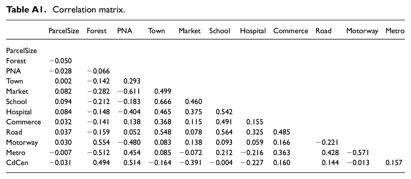
Table A1 in the appendix shows the correlation matrix between the continuous variables. No correlation is above 0.67 (between Town and School), and most correlations are below 0.4.
Model results are summarised in Table 3. Regression analysis and data processing were carried out using ordinary least squares (OLS), with a SHAC robust inference 1 on the model expressed in a semi-logarithmic form. We estimated four models, adding a different set of characteristics for each one 2 to analyse how the sign, size and significance of the coefficients associated with the various sets of characteristics evolve with the inclusion of the other attributes, given the correlations between some of our variables.
Estimation results.

Notes: Robust standard errors are reported in parentheses. *, ** and *** indicate significance at the 10%, 5% and 1% levels, respectively. Bs refers to B-spline function.
Source: Prepared by the authors.
The first set only includes the structural characteristics (Model 1: S). With an adjusted R-squared of 75.9%, the quality of adjustment is very satisfactory. The variable ‘parcel size’ has a nonlinear effect in the dependent variable, as two of the coefficients of the spline function, indicated by bs(Parcel Size)1, bs(ParcelSize)2 and bs(ParcelSize)3, are significant at 1%. Its effect on price is shown in Figure 2, and seems to be positive since the significant spline coefficients are positive: if the lot size increases, the price will also rise. Regarding urban services, none of these variables have a significant impact in this benchmark model.

Parcel size effect on land price.
In Model 2 (S+E), we added the environmental features to Model 1. A connection to piped water now becomes significant and positive. Concerning the environmental features, as a semi-log specification is used in all models, estimates can be interpreted as semi-elasticities, meaning that one unit change in the independent variables (in our case 1 m in the distance) will affect a percentage in the price. Distance to the forest and protected natural area (PNA) is significant with the expected sign, showing that as distance increases, land value declines. Nevertheless, the extent of the effect is negligible (for instance, a 1 m further away distance from the forest decreases the price by less than 0.01%). As expected, the slope variable is negatively related to the dependent variable.
Model 3 (S+E+N) further includes neighbourhood variables. The distance to school is the only variable with a significant impact at 1% with the expected sign. However, the inclusion of neighbourhood characteristics has the consequence of making the impact of distance to the forest and connection to piped water insignificant. The results for the other variables remain unchanged.
Finally, Model 4 (S+E+N+A) integrates the accessibility variables. The distances to the motorway and metro are negative and significant at 1% and 5% respectively, with the predicted sign, although the impact on the price is very low. As expected, distance to city centre was also statistically significant, with a non-linear yet globally decreasing impact (see Figure 3). With these new variables, some changes are worth noting. Access to piped-water connection becomes significant again, while the coefficient pertaining to PNA becomes insignificant and the forest’s estimate changes its sign and is only weakly significant. These changes can be explained by the correlation between distance to the forest/PNA and distance to the motorway, which is around 0.5 (see the appendix).

City centre’s effect on land price.
Discussion
Our empirical analysis allowed us to identify several variables that determine the prices of land parcels in the CL of Mexico City. Such variables were classified into four main groups of factors that help to understand how this market behaves, providing some insight into urban policy issues. Hence, in this section, we analyse each group of variables in turn (i.e. structural features, environmental variables, neighbourhood characteristics and accessibility attributes). The final section is then devoted to policy implications under this context.
Structural features
As expected, all four hedonic pricing specifications showed that there is a positive and strong significant relation between land price and parcel size, which is a standard result. As stated by Turner (1967), low-income households bet on a ‘progressive development’ of their homes; they prefer larger unfinished houses to small finished ones, as they are concerned about the future of their families and so look for more living space. Therefore, the price will increase as the parcel becomes larger. Furthermore, the availability of infrastructure services has a positive relationship with land price. However, piped water was the only significant variable in two of the models, whereas services like electricity and sewer systems apparently are not highly valued in this irregular market. This is in tune with Jimenez (1982), whose findings showed that sanitation services did not have a significant impact on housing value in squats in Manila, the Philippines. In fact, during our field work, it was observed that people with no access to water at home obtain it either from water tanks or street vendors. Although accessible, it involves an additional expense. Hence, new buyers might consider water availability as a fundamental factor in their decision to acquire a land parcel, while electricity and sewage systems are secondary.
Other studies elsewhere have demonstrated similar relations between infrastructure services and low-income housing markets. For example, Crane et al. (1997) showed that services associated with infrastructure provision are seen to be as valuable as, or more valuable than, other features. Analysing slums in two Asian mega-cities, the authors suggested that in Jakarta, residents would pay more for a piped-water connection than for a toilet, a sink, access to a well or a larger house. However, residents of Bangkok would prefer to incur the largest expense in paying for a legal connection to the electrical power grid, followed by for a high-pressure water connection and, a distant third, for sanitation. Similarly, Choumert et al. (2014) found a positive effect of piped water and electricity on rents in Kigali, Rwanda. Furthermore, Nakamura (2017) pointed out that for informal settlements, basic services may be a factor in improving the tenure security of residents, hence the great importance of having them. In the context of Mexico City’s outskirts, informal land parcel buyers place value first of all on the availability of a water connection. Indeed, water is vital and has no perfect substitute in other variables, thus purchasers expect that other public services will eventually be delivered with increasing urbanisation.
Environmental variables
There is a large amount of literature on environmental amenities in formal markets; nonetheless, studies focusing on informal markets often neglect environmental factors. Hence, the evidence presented here is important, as it highlights a statistically significant relationship between the price of land and the distance to the nearest forest and PNA. However, although significant, the regression coefficients have values close to zero, which means that buyers are aware of but rather indifferent to environmental features in this informal market, in contrast with formal housing markets elsewhere (Morancho, 2003; Saphores and Li, 2012; Sylla et al., 2019). Even in formal markets in developing countries, environmental quality has a large impact on property prices, as reported by Humavindu and Stage (2003) for Namibia. According to this result, Mexico City’s authorities should promote environmental education along with other strategies that we discuss below. Otherwise, as households do not seem to value environmental characteristics, this laissez-faire scenario will lead to the inexorable degradation of environmental assets in the short term.
In addition, our study confirmed that a sloped parcel will command a lower price because potential buyers seeking land parcels with residential purposes worry about the inclination of the land, given that building houses on slopes is costlier than on flat parcels.
Neighbourhood characteristics
In general, neighbourhood amenities influence housing and land prices. Distance to school was significant in one model. This is in line with the results of Sylla et al. (2019), which showed that peri-urban inhabitants seek to live near a school.
In the sense of valuing the neighbourhood amenities, it was expected that the distance to the market would have a positive effect since markets are commercial areas of supply, which would imply a benefit for the inhabitants. However, this variable proves to have a counterintuitive sign in both models (significantly so in Model 4). In other words, the closer to the market, the lower the price of the land. One way to account for this finding is that markets are also frequently associated with negative externalities (garbage, traffic congestion), and buyers tend to avoid them (Brasington and Hite, 2005).
Accessibility attributes
Although the percentage change in land value per metre of distance is very low, the distance to motorways, the metro and the city centre had a significant positive impact (negative coefficients) on land values. Thus, accessibility and distance to the city centre are as important features in this informal market as they are in formal markets. These results are in line with Zhang and Zhao (2018), whose findings showed that residents pay a higher price for informal homes if these are situated in better locations, and also with Sylla et al. (2019) who found the main determinant of the price of parcels in a peri-urban area to be closeness to the city.
Policy implications and conclusion
The empirical results presented here are important as policy recommendations for two reasons. On the one hand, land parcel purchasers in the CL of Mexico City mainly value urban characteristics. This ‘urban premium’ is the driver of the expansion of urban areas in many cities in the developing world. Furthermore, as shown elsewhere (Moschella, 2018), this is an unsolved problem of spatial planning (both urban and environmental). In urban and real estate terms, rising house prices have pushed low-income people to look for settlements in conservation areas. Furthermore, poor or non-existent enforcement of preservation areas has allowed uncontrolled urban sprawl. Therefore, the expansion towards natural areas is led by people looking for urban amenities rather than environmental ones. Indeed, individuals are willing to pay for basic services such as access to piped water, proximity to schools and accessibility features such as proximity to the city centre, motorways and metro stations. Even when these are not present, buyers arguably expect that such services will eventually be provided by local authorities, resulting in growing urbanisation.
On the other hand, people are aware of the distance to the forest and/or PNA but are rather indifferent to this. Indeed, distances to both the forest and the PNA influence the price of informal land parcels, but the value is very low. This is an interesting result because it provides evidence of the difference between how informal markets and formal markets value environmental amenities. In fact, Das et al. (2017) discovered that slum dwellers value a clean environment.
Thus, our findings suggest that these individuals look to cover their basic housing needs and will continue to occupy areas despite negative environmental effects that might be generated. Hence, the problem of irregular settlements must be approached from two different angles.
Firstly, informal inhabitants cannot be persuaded to halt the invasion and modification of natural areas without a comprehensive and properly enforced urban and environmental policy. Policy planners need to develop a multisectoral and integrated spatial policy which considers urban and environmental areas as a unified system, to improve urban sustainability. Thus, changing the perception that green areas are potential urbanisation opportunities is paramount.
Moreover, urban dwellers must be sensitised to the whole value of the CL. For example, recognition of the importance of natural reserves to society through ecosystem services should be strongly promoted for all inhabitants, both land buyers and traders. In this vein, compensation schemes could be implemented and, consequently, prevent landowners (ejidos, communities and private) from selling their properties.
Furthermore, the idea of creating containment zones or green belts has been implemented in several countries for many decades as an effective land use planning policy (Pendall et al., 2002). However, in the case of Mexico, it has not been properly enforced, and people continue to settle in unauthorised territories. Indeed, purchased lands, despite their conservation status, eventually end up being regularised when the green spaces are already decimated, and a certain degree of urban consolidation is reached. In this sense, two ways of action can be undertaken.
The first path is to re-locate settlements from natural areas, to restore the affected areas and ensure their conservation. Nevertheless, the eviction of inhabitants is a delicate matter (Everett, 2001). The second path is containment, and focuses on preventing settlements from growing and spreading. In such cases, authorities can apply market measures (e.g. taxes and fines). As stated above, the expectation of buyers that the land-use change of conservation areas into urban use is a profitable opportunity should somehow be penalised. Land readjustment strategies such as re-location, on the one hand, and legalisation, on the other, can be considered but must be carefully planned.
In this sense, the second recommendation is that public policy needs to solve the housing demand and provide areas to cope with the increasing challenge of dwelling. This hedonic pricing analysis showed irregular land parcel buyers seeking urban features, such as drinking water connection, basic education and transport supply, while not paying a premium for green space proximity. Parcel size is also an important characteristic, as buyers look for parcels large enough to allow incremental growth of their home as their incomes improve and their families grow. Hence, satisfying the housing demand must include the attributes presented here. Effective housing projects need to be designed considering the preferences of target groups (Nassar and Elsayed, 2018).
Over the past 40 years, the urban expansion of the southern periphery of Mexico City has failed to be controlled despite the establishment of Conservation Land, multiple restrictions on land use and containment zones. The findings from this article contribute to the understanding of how land markets work when dealing with informal parcels, providing helpful guidelines for policy planning purposes. Consequently, an effective spatial and social policy should consider environmental protection, on the one hand, and access to housing, on the other. At present, little is known about the values that individuals in illegal settlements assign to green spaces, and therefore further research is essential.
Footnotes
Appendix
Correlation matrix.
| ParcelSize | Forest | PNA | Town | Market | School | Hospital | Commerce | Road | Motorway | Metro | |
|---|---|---|---|---|---|---|---|---|---|---|---|
| ParcelSize | |||||||||||
| Forest | −0.050 | ||||||||||
| PNA | −0.028 | −0.066 | |||||||||
| Town | 0.002 | −0.142 | 0.293 | ||||||||
| Market | 0.082 | −0.282 | −0.611 | 0.499 | |||||||
| School | 0.094 | −0.212 | −0.183 | 0.666 | 0.460 | ||||||
| Hospital | 0.084 | −0.148 | −0.404 | 0.465 | 0.375 | 0.542 | |||||
| Commerce | 0.032 | −0.141 | 0.138 | 0.368 | 0.115 | 0.491 | 0.155 | ||||
| Road | 0.037 | −0.159 | 0.052 | 0.548 | 0.078 | 0.564 | 0.325 | 0.485 | |||
| Motorway | 0.030 | 0.554 | −0.480 | 0.083 | 0.138 | 0.093 | 0.059 | 0.166 | −0.221 | ||
| Metro | −0.007 | −0.512 | 0.454 | 0.085 | −0.072 | 0.212 | −0.216 | 0.363 | 0.428 | −0.571 | |
| CdCen | −0.031 | 0.494 | 0.514 | −0.164 | −0.391 | −0.004 | −0.227 | 0.160 | 0.144 | −0.013 | 0.157 |
Acknowledgements
The authors thank colleagues from CESAER for helpful remarks and suggestions on a former draft, and the anonymous reviewers for their insightful comments.
Declaration of conflicting interests
The author(s) declared no potential conflicts of interest with respect to the research, authorship, and/or publication of this article.
Funding
The author(s) disclosed receipt of the following financial support for the research, authorship, and/or publication of this article: The work was supported by the Mexican Council for Science and Technology (CONACYT) [grants 295890, 291250 and 179301] and by UNAM-PAPIIT IN301919. ETMJ was a visiting scholar at CESAER, France in August to December 2018.
