
Abstract
Neighbourhood places like shops, cafes and parks support a variety of social interactions ranging from the ephemeral to the intimate. Repeated interactions at neighbourhood places over time lay the foundation for the development of social cohesion and collective efficacy. In this study, we examine the proposition that changes in the presence or arrangement of neighbourhood places can destabilise social cohesion and collective efficacy, which has implications for crime. Using spatially integrated crime, social survey and parcel-level land-use classification data, we estimate mixed effects panel models predicting changes in theft and nuisance crimes across 147 Australian neighbourhoods. The findings are consistent with neighbourhood social control and crime opportunity theories. Neighbourhood development – indicated by fewer vacant properties and fewer industrial and agricultural sites – is associated with higher collective efficacy and less crime over time. Conversely, introducing more restaurants, transit stations and cinemas is associated with higher theft and nuisance over time regardless of neighbourhood collective efficacy. We argue that the addition of socially conducive places can leave neighbourhoods vulnerable to crime until new patterns of sociability emerge and collective efficacy develops.
Introduction
Individual places that facilitate social conviviality are fundamental features of local neighbourhoods. Neighbourhood places provide material needs for residents and visitors. The less tangible benefits of individual places like parks, shops and cafes arise from their ability to collectively enhance opportunities for social interaction in a given neighbourhood (Baum and Palmer, 2002; Patch, 2008; Zukin et al., 2009). Both the presence and spatial arrangement of places in the neighbourhood influence how opportunities for social interaction emerge via their capacity to funnel population movement and control flows of people (Small and Adler, 2019). Passive sociability can arise as a function of routine daily activities when individuals encounter one another as they move through and use neighbourhood places. Particular types of places within the neighbourhood facilitate lingering and active social engagement by design (Hillier and Hanson, 1984; Mehta and Bosson, 2009). For example, parks and street-front shops, commonly patronised by local residents, can facilitate repeated social interactions between neighbours over time (Small and Adler, 2019; Zukin et al., 2009). Alternatively, places like industrial buildings, cemeteries and hospitals can create social holes, and features such as rail lines and highways can physically fragment neighbourhoods, by restricting mobility and hindering opportunities for people to come together (Hipp et al., 2014; Wickes et al., 2018). By influencing the potential for social interaction, neighbourhood places can indirectly affect neighbourhood cohesion and capacity for informal social control, with implications for collecive efficacy and crime (Sampson et al., 1997).
Collective efficacy develops when social cohesion is coupled with informal social control (Sampson et al., 1997). It relies on a sense of familiarity among individuals and the perception of shared values and norms (Sampson, 2012). Neighbourhood places that facilitate social interaction provide opportunities to build cohesive relationships of trust, shared values and cooperation for crime prevention (Kurtz et al., 1998; Peterson et al., 2000). Herein, we refer to such places as social conduits (Wickes et al., 2018). Social conduits are places beyond work and home that support both active and passive human interaction (e.g. meeting and talking with others; watching people doing activities) (Wickes et al., 2018). Neighbourhoods with a greater number of social conduits present more opportunities for social interaction, which may enhance collective efficacy (Wickes et al., 2018). Yet when social conduits are removed from the neighbourhood or the spatial arrangement of social conduits changes over time, this may shift patterns of sociability, potentially disrupting a sense of familiarity and the shared values and norms that underpin collective efficacy. In this case, residents lose inclination to intervene when problems occur because the individuals involved are unfamiliar or they are unsure how other members of the community will react to their intervention (Sampson, 2013). This situation can lead to increases in crime opportunities (Sampson, 2006, 2012).
Crime opportunities emerge when motivated offenders and suitable targets converge at places where capable guardians are absent or less inclined to intervene (Cohen and Felson, 1979). Places visited by motivated offenders to covertly engage in illegal activities are crime attractors (e.g. vacant lots and industrial sites). Places where crime opportunities emerge, as potential offenders and targets undertake legitimate activities, are referred to as crime generators (Brantingham and Brantingham, 1995). Under certain social, demographic and economic conditions, crime generators may be considered social conduits given that both types of places facilitate social interactions. While social conduits facilitate prosocial interactions, crime generators facilitate deviance (Brantingham and Brantingham, 1995; Wickes et al., 2018). When collective efficacy is high and individuals undertaking legitimate activities engage in surveillance, opportunities for crime are low (Cohen and Felson, 1979; Jacobs, 1961). However, changes in neighbourhood places that alter patterns of regular social interaction and the capacity of the neighbourhood to develop and maintain collective efficacy may increase crime vulnerability. As such, social conduits may act as crime generators until patterns of regular social interaction develop once more.
To date, scholarship on neighbourhood change has focused primarily on the association between changes in population composition and crime (see Kirk and Laub, 2010, for an in-depth review of the neighbourhood change and crime literature). Studies also consider specific processes of neighbourhood growth, decline and instability such as gentrification (Balzarini and Shlay, 2018; Papachristos et al., 2011), mass foreclosures (Ellen et al., 2013) and natural disasters (Curtis et al., 2013; Zahnow et al., 2017). Yet, for the most part, this research is limited to demographic and economic indicators of neighbourhood status, or focuses on the addition or removal of one particular type of facility. Examples include case studies on increases in coffee shops (Papachristos et al., 2011), on the temporary closure of a train station (Phillips and Sandler, 2015) and on stadia during periods of closure (non-game days) (Kurland, 2019). This research provides insight into how the changing presence of places can socially impact communities, but the generalisability of the findings to other neighbourhoods is limited. Further, the studies do not capture the real-life incremental shifts that occur within neighbourhoods as a collective context over time.
In this study, we classify neighbourhood places based on expected patterns of legitimate use and their capacity to facilitate social interaction. We add to the current scholarship by examining the association between changes in the presence and spatial arrangement of neighbourhood places and (a) collective efficacy, and (b) crime. Drawing on crime opportunity theories and theories of neighbourhood social control, we hypothesise that changes to neighbourhood places will leave communities vulnerable to crime until new patterns of natural surveillance emerge and collective efficacy develops.
Background
Places are inherently social. Without people, places are denuded of meaning and are merely space. In contrast to the fluidity of social life, places are ‘bricks and mortar’ and provide relative stability (Felder and Pignolo, 2018). Places scaffold people’s daily routines and provide the framework for social interaction to occur. Places like shops, cafes, schools and restaurants can enhance neighbourhoods by facilitating social interactions ranging from ephemeral encounters to scheduled meetings (Baum and Palmer, 2002; Small and Adler, 2019; Wickes et al., 2018). Social cohesion and shared behavioural norms develop over time, through interactions that occur at these socially conducive places (Felder and Pignolo, 2018; Massey, 1994; Oldenburg, 1989). Collectively, we refer to places that facilitate neighbourhood sociability as social conduits (Corcoran et al., 2018; Wickes et al., 2018).
Social conduits are conceptually similar to Oldenburg’s (1989)‘third places’ in that in addition to their primary function, they can facilitate the convergence of individuals required for social interaction (Anderson, 2011; Oldenburg, 1989; Wickes et al., 2018). Social conduits vary greatly in features, form and function and thus support different types of social interactions (Wickes et al., 2018). While some social conduits provide essential amenities for local residents and enhance capacity for neighbour-based encounters, others attract individuals from broader catchment areas and increase the presence of visitors in the local area (Wickes et al., 2018). Similarly, while certain places facilitate specific scheduled activities, others are multi-functional where patterns of visitation are temporally and typologically disparate. Thus, different types of social conduits can support interactions ranging from the incidental to the organised and regular. Variation in the type of interactions supported at particular places can have a flow-on effect for the development of social cohesion and collective efficacy (Baum and Palmer, 2002; Sampson et al., 1997).
We categorise social conduits into four broad groups based on their social interaction potential. Anchoring conduits facilitate repeated interactions between the same group of individuals (e.g. schools, churches), while local exposure conduits encourage unscheduled, less frequent interactions between local residents (e.g. local parks, corner shops). Scheduled conduits facilitate scheduled activities with locals and visitors (e.g. restaurants, cinemas, train stations), and extra-local conduits are those that attract both locals and visitors at all times (e.g. shopping malls). 1 While each type of conduit is expected to have a distinct influence on social interaction at the micro level, the combination and arrangement of social conduits influence the social interaction potential at the neighbourhood level. Thus, the presence of social conduits indirectly impacts social ties (Duncier, 1992; Furman, 1997; Oldenburg, 1989), collective efficacy and crime (Hipp et al., 2014; Klinenberg, 2002) by providing physical opportunities for individuals to come together to form pro-social bonds and develop shared norms of behaviour.
Previous studies have elucidated the social benefits of particular neighbourhood features (Baum and Palmer, 2002; Mehta and Bosson, 2009; Whyte, 1980). In a study of social cohesion in Dutch neighbourhoods, van Bergeijk et al. (2008) found that residents who shopped daily in the local area, visited cafes and restaurants at least once a month and/or visited community centres had larger social networks and expressed a greater sense of social belonging than those who did not use local facilities. Similarly, Cabrera and Najarian (2015) found that more frequent use of local shops and businesses (foci such as the yoga studio, fitness centre, cafe) resulted in residents having more bridging social ties (see also Völker et al., 2007). Many of these studies focus on the individual, proposing that as people go about their daily activities at local places, they inadvertently participate in neighbourhood social life and contribute to the actual and perceived social cohesion (Granovetter, 1983). Interaction with others can also lead to the development of collective values and behavioural norms that can be activated when community problems such as crime and disorder arise, which is referred to as collective efficacy (Granovetter, 1983; Kleinhans and Bolt, 2014). The benefits of neighbourhood social cohesion and its extension, collective efficacy, for individuals and at the neighbourhood level are widely reported. Living in a collectively efficacious neighbourhood is associated with better health and wellbeing (Browning and Cagney, 2002; Kawachi and Berkman, 2001), while collective efficacy at the neighbourhood level predicts better childhood outcomes, better disaster recovery (Kawachi and Berkman, 2001; Paton, 2010) and, importantly, reduced crime (Morenoff et al., 2001; Sampson et al., 1997). Even at the level of the individual street segment, higher collective efficacy is associated with lower crime (Weisburd et al., 2020).
While social conduits provide opportunities to develop and maintain collective efficacy, other features threaten social cohesion by physically fragmenting neighbourhoods. Physical fragmentation describes a physical-spatial phenomenon whereby highways and rail lines create interstitial places that disrupt the urban fabric. By acting as a physical barrier to mobility and interaction, extensive infrastructure can undermine the development of social cohesion across the neighbourhood as a whole and instead limit social interactions to those sharing a common ‘fragment’ of the neighbourhood (Hipp et al., 2014). However, Grannis (1998) notes that smaller streets within neighbourhood fragments play a primary role in fostering social relations – albeit in a racially and spatially segregated pattern. Similarly, Appleyard and Lintell (1972) found people perceive ‘heavy streets’ to be associated with strangers and to serve only as a corridor between the local neighbourhood and external areas. On the contrary, smaller residential streets were perceived as the basis of ‘lively, close-knit communities’ (Appleyard and Lintell, 1972: 93). Hence, while it is evident that highways and rail lines physically fragment neighbourhoods, it remains unclear whether fragmentation has a positive or negative impact on social cohesion across the neighbourhood as a whole.
Social conduits, collective efficacy and crime longitudinally
Considering that social conduits enable social interactions (Simmel, 1997 [1903]; Small and Adler, 2019) and facilitate the development of social cohesion (van Bergeijk et al., 2008), it is reasonable to hypothesise that additions, removals or changes in the arrangement of social conduits over time may destabilise social cohesion and collective efficacy, with implications for crime (Zukin et al., 2009). For the most part, physical neighbourhood change is slow and almost imperceptible at the aggregate level. A local shop may close down and be replaced by a new restaurant, or a new fitness centre may appear in a previously undeveloped space. In isolation, these changes may have little impact on the social interaction potential at the neighbourhood level. However, we assert that the combinatorial influence of these changes and reconfigurations may significantly alter the potential for sociability and norm development.
Since the turn of the century, urban scholars have problematised neighbourhood change. Processes of urbanisation and gentrification have been scrutinised and lamented for displacing vulnerable residents (Barton and Gruner, 2016; Freeman et al., 2015), segregating cities (Freeman, 2009) and depersonalising social interactions (Simmel, 1997 [1903]; Wirth, 1938). Theories of neighbourhood change, including invasion/succession (Park et al., 1925) and neighbourhood life-cycle models (Hoover and Vernon, 1959), acknowledge the inevitability of neighbourhood change but retain a negative framing of neighbourhood decline and population turnover. Despite a longstanding interest in the idea of neighbourhood change and its implications for social interactions and crime, empirical scholarship is largely limited to studies assessing changes in the socio-demographic composition of neighbourhoods over time (Galster et al., 2007; Kirk and Laub, 2010). Commonly, the mechanisms proposed to explain the association between population changes and crime align with those described here, suggesting that neighbourhood change destabilises regular patterns of interaction. When this occurs, social cohesion and collective efficacy are reduced, which lowers the risk to offenders and increases the likelihood of crime. Prior work provides partial support for this argument. In a study of Chicago neighbourhoods, Becker (2016, 2019) finds that neighbourhood change disrupts collective efficacy, which contributes to higher violence.
Other processes of neighbourhood growth, decline and (in)stability, such as gentrification, have received greater attention in recent years. While gentrification is concerned with neighbourhood renewal, the majority of studies focus on changes in neighbourhood status using census indicators such as housing value, field of employment or average income (Ohmer et al., 2018; Teernstra and van Gent, 2012) and do not assess the changes in the presence or arrangement of neighbourhood places. Two exceptions include a study examining the impact of increased coffee shops on crime over time in Chicago neighbourhoods (Papachristos et al., 2011), and a study exploring the influence of changes to the retail landscape in two New York City neighbourhoods on social interactions (Zukin et al., 2009). These studies demonstrate that the addition of social conduits can facilitate lower crime (Papachristos et al., 2011), provide opportunities for social interaction (Zukin et al., 2009) and serve as a symbol of neighbourhood improvement (Macintyre et al., 2008). However, the removal of long-term businesses or shops may dislocate social bonds and interrupt informal street activity associated with surveillance (Macintyre et al., 2008; Zukin et al., 2009). Evidence suggests that neighbourhood change, either positive or negative, tends to be socially disorganising at least in the short term (Kreager et al., 2011; Papachristos et al., 2011).
The proposition that changes in the presence and arrangement of social conduits will be socially disorganising at the neighbourhood level is supported by crime opportunity theories and theories of neighbourhood social control. From a crime opportunities perspective, locales characterised by low levels of informal guardianship (Reynald, 2018) or those that do not support natural surveillance by individuals undertaking legitimate and routine activities, provide more attractive crime opportunities to offenders (Clarke, 1995; Wilcox et al., 2007). Some types of places, referred to as crime generators, are more susceptible to crime because their primary function results in the convergence of crowds, made up of individuals who may be locals or visitors (Brantingham and Brantingham, 1995). While the label of crime generator incites negative connotations, they are areas where many people come together with legitimate intentions, yet crowd density can create temporary gaps in surveillance and reduced capacity for intervention, producing opportunities for crime (Reynald, 2018).
Drawing on the tenets of social disorganisation and collective efficacy theories, criminal behaviour is more likely to be monitored and individuals are more likely to intervene when social disorganisation is low and social cohesion and mutual trust among residents are high (Sampson, 2012; Sampson et al., 1997; Shaw and McKay, 1942). Social cohesion and mutual trust are developed through repeated encounters at places over time (Granovetter, 1983; Hipp, 2016; Sampson et al., 1997). Associational social ties formed through repeated interactions provide opportunities for the transmission of behavioural norms and the development of a collective sense of familiarity that supports willingness to intervene on behalf of the common good (Gau, 2014; Granovetter, 1983; Kasarda and Janowitz, 1974; Sampson, 2006). Subsequently, neighbourhoods undergoing change may be left vulnerable to crime while new patterns of social interaction and natural surveillance emerge and collective efficacy develops. Even in places where collective efficacy is initially high, this may be destabilised by changes to the neighbourhood physical environment that alter the patterns of regular social interactions that form the basis of collective efficacy (Hipp, 2016).
The current study
Previous studies have suggested that (a) neighbourhood places provide settings for pro-social and/or deviant interaction to occur, and (b) neighbourhood change, when measured demographically, can be disorganising, at least in the short term. Our study brings together crime opportunities and neighbourhood social control theories to examine the effect of changes in the presence of neighbourhood places on collective efficacy and crime. This research extends the scholarship in three key ways. First, we employ a longitudinal framework to capture the relationship between changes in socially conducive places and crime. Second, while previous studies have been limited to examining the impact on crime of one type of facility, such as bars (Jay, 2020; Roncek and Maier, 1991; Wheeler, 2018) or parks (Boessen and Hipp, 2018; McCord and Houser, 2017), we simultaneously consider multiple types of neighbourhood amenities. This approach limits the potential for measurement bias arising from the effect of unmeasured neighbourhood features. Third, our data encapsulate 147 neighbourhoods that have experienced varying patterns of growth, decline and stability over the period of investigation. This is in comparison with studies on neighbourhood physical change that focus on single case study neighbourhoods (e.g. Zukin, 2009).
Data and methods
This study utilises three waves of the Australian Community Capacity Study (ACCS) conducted in 2008, 2010 and 2012 respectively. The ACCS is a longitudinal survey of randomly selected residents from 148 Australian neighbourhoods (Wave 2 n = 4088; Wave 3 n = 4167; Wave 4 n = 4132). 2 Survey participants respond to a range of questions about their local community, which they are informed refers to their residential suburb. This is the unit of analysis for this study and we refer to it throughout as the neighbourhood. Neighbourhood populations in our sample range from 258 to 22,800, while numbers of participants drawn from each neighbourhood range from 11 to 47 (mean = 30) 3 (see https://accs.project.uq.edu.au/).
Dependent variables
Collective efficacy: We computed a scale comprising seven items from the ACCS to capture respondents’ perceptions of collective efficacy. The scale comprises items that are identical to those used in the Project on Human Development in Chicago Neighborhoods in the original study of collective efficacy (Sampson et al., 1997). The dependent variable for Model 1 is the latent neighbourhood-level scale score.
Crime: Crime data for this study consist of counts of property theft and public nuisance offences recorded by the Queensland Police Service from 2008 to 2012. We focus on theft and nuisance as these are crimes of opportunity that take place when informal social control is absent or weak. Further, as we are examining the impact of changes in the presence of social conduit types across a variety of neighbourhood contexts, we wanted to ensure that the examined crime types were possible regardless of primary land use. For example, it is not possible for burglary to occur at the park. Our selection of crime types was also based on data availability; both theft and nuisance occur with adequate frequency across our sample of neighbourhoods during each period to model crime across all three time points.
Neighbourhood social conduits
We use the Digital Cadastral Database (DCDB) and the Queensland Valuation and Sales (QVAS) land use data to categorise land parcels into four types, based on their capacity to generate interaction and opportunities for social control (Corcoran et al., 2018; Wickes et al., 2018). The variable for each category is the total number of places log transformed to address the potential for outliers.
Type 1 – Anchoring conduits encourage repeated interactions between the same individuals. This type includes schools, public libraries, childcare centres, gyms/health clubs and churches/religious facilities.
Type 2 – Local exposure conduits are places that support encounters with other frequent users at sporadic and unscheduled points in time. These facilities are not the sites of scheduled activities; rather, they are sites with localised catchments that may encourage acquaintanceship ties between regular users. This type includes neighbourhood parks and single or row street-front shops.
Type 3 – Scheduled conduits facilitate scheduled activities with a variety of local and extra-local users. These facilities can be busy places at particular times and are associated with particular functions including local restaurants, cinemas, theatres and train stations.
Type 4 – Extra-local exposure conduits are places that attract a variety of local and extra-local users. These features have large catchment areas and facilitate incidental encounters between diverse groups of people, such as large malls or shopping complexes.
In addition to social conduits, we include two other land use classifications that may be important for barriers for neighbourhood social interaction potential:
Social holes are places that are not openly accessible to the public or are open to the public but do not encourage social interaction. The features included in this type are cemeteries, defence force bases, industrial buildings and large hospitals.
Undeveloped parcels includes vacant house blocks, bushland or state controlled national parks but excludes neighbourhood parks belonging to the local exposure conduit type. These are empty spaces that do not contain any amenities that would encourage social interaction.
Physical fragmentation: In addition to the presence of places that facilitate social interaction, the physical arrangement of neighbourhood land use types may also influence the likelihood of social encounters. This physical arrangement is captured as an index revealing the degree to which residential and social spaces within the neighbourhood are fragmented by highways, rail lines and waterways. The fragmentation index measures the probability that two randomly selected points in the neighbourhood will be located in a single fragment, thus a greater number of fragments reduces this probability. Lower values indicate fewer neighbourhood fragments while higher values indicate more neighbourhood fragments.
Neighbourhood social and demographic characteristics
Neighbourhood social-demographic characteristics were drawn from the Australian Bureau of Statistics’ census of population and housing for the time points 2006 (Wave 2) and 2011 (Wave 4). Standard linear interpolation was performed with three time points (2001, 2006 and 2011) to provide data for Wave 3. Variable selection was informed by the theoretical and empirical scholarship, highlighting key determinants of social disorganisation and neighbourhood crime; economic disadvantage; ethnic diversity; residential mobility; and population density (Sampson et al., 1997; Shaw and McKay, 1942). Economic disadvantage is the percentage of neighbourhood households that earn less than AU$799 per week. Residential mobility is the percentage of households reporting a different address five years prior. To account for ethnic diversity, we include a measure of language diversity using a Blau index of the nine main language categories reported in the Australian census (Blau, 1977). We also include a measure of population density. Summary statistics for all variables are presented in Table 1.
Summary statistics (n = 147 neighbourhoods).

Analytic approach
We adopt a mixed effects modelling approach to examine the association between change in neighbourhood social conduits, collective efficacy and crime over time. Mixed effects panel models are appropriate as they provide capacity to allow the intercept and slope to vary across neighbourhoods in the sample, allowing the models to capture both between-neighbourhood and within-neighbourhood effects (Allison and Waterman, 2002). The model estimates are for panel models for i = 1…., N where N is the number of neighbourhoods (147) and t = 1, …T where T = 3 corresponding to the three ACCS survey waves. We employ a linear regression panel estimator to model collective efficacy, given that this variable reflects a normal distribution (see Appendix 1). The basic form of the model is as follows:

where
The coefficients (Model 1) and incidence rate ratios (IRR) (Models 2 and 3) include both the within-neighbourhood and between-neighbourhood effects. In the case of our models, coefficients and IRRs represent the average effect of the independent variable over collective efficacy and crime when the independent variable changes across time and between neighbourhoods by one unit. Tests for multicollinearity revealed all variance inflation factors (VIFs) were below two and correlations were not problematic. 4 All analyses were conducted in Stata 14.0 (StataCorp, 2015).
Preliminary analysis: Visual depiction of change in the study site (Brisbane)
Brisbane, our case study context (Figure 1a), is one of the fastest growing cities in Australia, with the census noting a 9.9% increase in population between 2011 and 2016. This population growth, and related residential and commercial development, has been unevenly distributed across the city. Figure 1a displays the spatial distribution of Brisbane’s population growth, highlighting that while many pockets of Brisbane experienced rapid population growth from 2011 to 2016, some neighbourhoods (73 in total) actually experienced a decline in population. Consummate with population changes, places within neighbourhoods also changed over the study period. Figure 1b reveals the spatial distribution of neighbourhoods where social conduits, social holes and physical fragmentation increased, decreased or remained stable over the five-year observation period. While illustrating that all neighbourhoods within Brisbane experienced some type of physical change, this change was not consistent either within or between neighbourhoods, nor across the types of neighbourhood places. Rather, Brisbane neighbourhoods were subject to unique combinations of gains and losses in social conduits, social holes and changes in fragmentation. In the following analyses, we employ panel regression models with random effects to best capture the effect of both within-neighbourhood change in conduits and between-neighbourhood variations in conduits on crime.
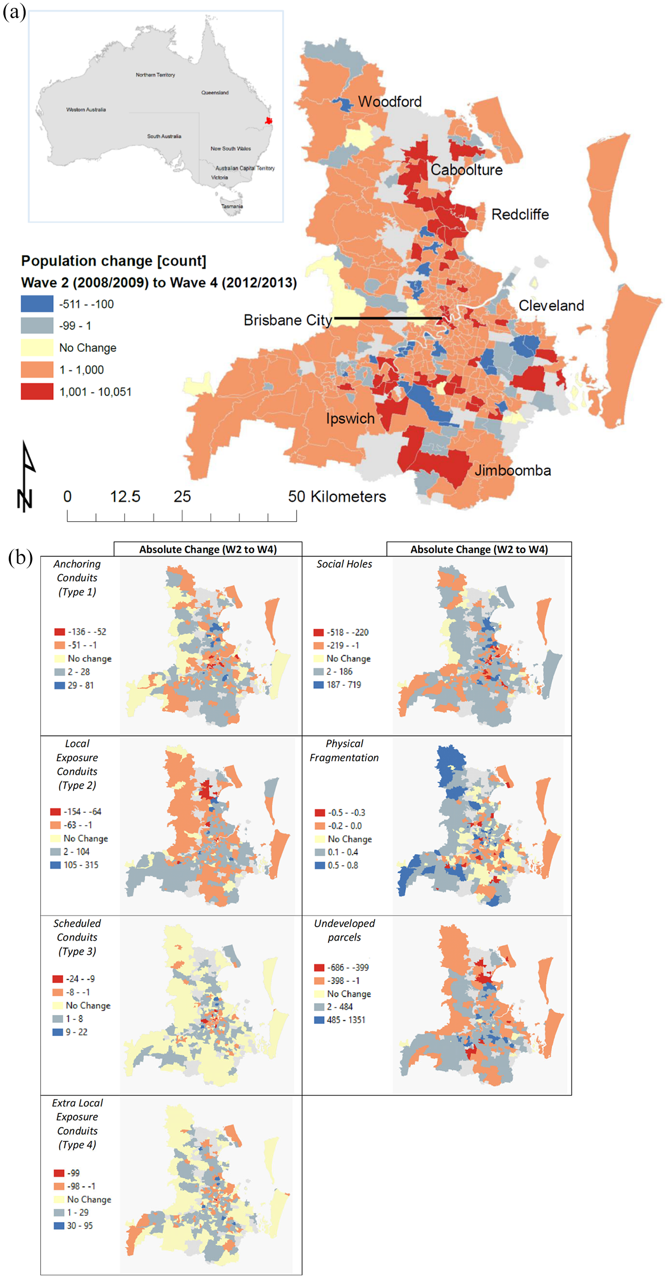
a) The case study context (Brisbane Statistical Division) and population change (count) by neighbourhood between Wave 2 (2008/2009) and Wave 4 (2012/2013); b) Changes in neighbourhood social spaces between Wave 2 (2008/2009) and Wave 4 (2012/2013) across the case study context (Brisbane Statistical Division).
Results
Table 1 presents descriptive statistics for each of the variables of interest. Model results are presented in Table 2.
Mixed effects panel model results.

Notes: N = 147 neighbourhoods, T = 3, 441 observations. ^p < 0.1. *p < 0.05. **p < 0.01. ***p < 0.001.
Model 1 reveals that decreases in social holes (B = −0.025, p < 0.01) and undeveloped land over time (B = −0.043, p < 0.001) are associated with higher collective efficacy, as is increased physical fragmentation (B = 0.103, p < 0.05). Over time, reductions in diversity (B = −666, p < 0.001) and increases in residential mobility (B = 0.004, p < 0.001) are also associated with higher collective efficacy. Given that many neighbourhoods have grown and developed in Brisbane, the relationship between the percentage of new residents in the neighbourhood and enhanced collective efficacy is in line with what we would expect, as this growth likely signals prosperity and neighbourhood enhancement. There is no significant association between social conduits and collective efficacy over time.
In relation to property theft, Model 2 reveals that lower collective efficacy is associated with higher theft over time (B= −0.351, p < 0.001). The model also shows that increases in scheduled social conduits (cinemas, restaurants, train stations) (B = 0.075, p < 0.01), social holes (B = 0.047, p < 0.01) and fragmentation (B = 0.239, p < 0.01) are associated with more theft over time. After controlling for collective efficacy, higher disadvantage (B=0.015, p<0.001), diversity (B = 1.311, p < 0.001), mobility (B =−0.009, p < 0.01) and density (B = 0.017, p < 0.001) are associated with higher recorded theft over time, as we would expect from previous social disorganisation research. There is no significant association between anchoring, local exposure or extra-local exposure conduits and theft over time.
Model 3 shows that nuisance displays similar results to the theft model. The results suggest that reductions in collective efficacy are associated with higher recorded offences (B=−0.351, p < 0.01). Increases in scheduled social conduits (cinemas, restaurants, train stations) (B = 0.092, p<0.05), undeveloped land (B = 0.057, p < 0.05) and disadvantage (B = 0.027, p < 0.001) also indicate higher nuisance over time. There is no significant association between anchoring, local exposure or extra-local exposure conduits and nuisance crimes over time.
Discussion
Neighbourhoods play a central role in people’s daily lives. Places within neighbourhoods provide a range of services and amenities. They also generate social interaction potential by bringing individuals together during their daily routines. Some neighbourhood places such as social conduits facilitate pro-social interactions, and consequently support the development of social cohesion and the transmission of behavioural norms (Cattell et al., 2008). Neighbourhoods with a greater number of social conduits have higher interaction potential that may support the development of collective efficacy. The current study explored how changes in the presence and arrangement of social conduits, social holes and physical fragmentation are associated with collective efficacy, theft and nuisance crime over time. We classified places that facilitate passive or active human interaction as social conduits, and features that discourage social conviviality as social holes and physical fragmentation. We hypothesised that changes in the presence or arrangement of social conduits and holes within neighbourhoods over time would incur neighbourhood-level changes in (a) collective efficacy, and (b) theft and nuisance crimes. Drawing on crime opportunities and neighbourhood social control theories, we hypothesised that, as a result of shifting patterns of interaction that enable the development of familiarity, shared values and norms, changes in the physical environment would disrupt collective efficacy and provide opportunities for crime, at least in the short term (Anderson, 1990; Kreager et al., 2011; Stucky and Ottensmann, 2009). Our findings partially support this hypothesis, although some results were unexpected.
First, social conduits were not associated with collective efficacy over time. Rather, fewer social holes and less undeveloped land in neighbourhoods over time may be beneficial for collective efficacy. Social holes comprise land uses that detract from the social fabric by discouraging thoroughfare and therefore limiting opportunities for social interactions (Hipp et al., 2014). Similarly, undeveloped land and vacant properties provide limited social interaction potential. A reduction in these types of places over the time period considered, along with increases in physical fragmentation and residential mobility, indicate conditions associated with the process of gentrification and/or land use conversion (Barton and Gruner, 2016; Papachristos et al., 2011). Similar to prior research on gentrification, our results suggest that when neighbourhoods undergo physical development characteristic of this process, it can support the growth of collective efficacy and reduced crime over time (Papachristos et al., 2011; Steinmetz-Wood et al., 2017; Zukin et al., 2009). While the benefits of gentrification and neighbourhood physical upgrade have been noted in previous studies, scholars have also highlighted that the process by which existing neighbourhood places are replaced by amenities that cater to the in-coming middle-class populace can exclude long-term residents (Barton and Gruner, 2016) and in particular racial minority groups (Hyra, 2017). While our results suggest that neighbourhood physical development may be associated with greater collective efficacy over time, this is not necessarily at odds with the suggestion that particular individuals or groups in the community are socially and physically displaced by such development (Atkinson, 2004; Barton and Gruner, 2016). For example, removal of social holes, including industrial establishments and factories, may provide social benefits for incoming residents while at the same time equating to employment loss for some long-time residents by forcing them to relocate.
Model 2 predicting theft and Model 3 predicting nuisance crimes across time both demonstrated some support for our hypothesis that changes in collective efficacy and requisite changes in the presence and arrangement of social conduits, social holes, undeveloped land and physical fragmentation have implications for crime. Results show that within-neighbourhood increases in scheduled conduits (type 3 conduits) and social holes / undeveloped land, along with decreases in collective efficacy, are associated with higher theft and nuisance crimes. Taken together, model results predicting collective efficacy (Model 1), theft (Model 2) and nuisance crimes (Model 3) can be interpreted to suggest that within-neighbourhood change in social holes influences collective efficacy (Model 1) and in turn crime (Models 2 and 3). Yet the addition of scheduled conduits (type 3 social conduits) is not associated with collective efficacy (Model 1), suggesting that scheduled conduits influence crime directly by creating opportune settings for theft and nuisance (Models 2 and 3). Scheduled conduits align most directly with typical crime generators (Brantingham and Brantingham, 1995) in that they act to bring people together for legitimate purposes, but, due to their tendency to (a) attract local and extra-local visitors, and (b) generate crowds, they can facilitate temporally bounded gaps in surveillance and ephemeral dilution of localised familiarity at places. Such situations discourage active guardianship and create crime opportunities that can be exploited by would-be offenders (Reynald, 2014; Reynald and Elffers, 2009). Thus, an increase in these types of places is associated with more crime but not necessarily weaker collective efficacy at the neighbourhood level.
A limitation of many studies examining the impact of neighbourhood places on crime is that they lack data to capture localised social processes over time. So, while existing scholarship provides rich theoretical propositions regarding the potential mechanisms through which neighbourhood places exert an influence on crime, empirical assessments that unpack the process over time are limited. As our models do not establish temporal ordering, we do not fully address this issue here. Nonetheless, our findings do highlight that some neighbourhood places impact both collective efficacy and crime over time while others only impact crime. This suggests that features contributing to collective efficacy, and collective efficacy itself, may be unevenly distributed within individual neighbourhoods. This aligns with Weisburd and colleagues’ (2020) findings evidencing the relevance of collective efficacy at the level of the street segment for crime, and supports the need to further consider the role of micro-places in the development and maintenance of social processes that facilitate informal social control.
As our study focused on the neighbourhood as the unit of analysis, we were not able to establish the extent to which within-neighbourhood shifts in social conduits or social holes may displace crime and/or pro-social opportunities to other areas within the same neighbourhood or the requisite impacts of such shifts on collective efficacy in smaller spatial units. To capture this phenomenon requires the computation of additional metrics such as the Moran’s I (Moran, 1950) to measure the spatial arrangement of social conduits. While our measure of spatial arrangement captures the level of fragmentation of all places in the neighbourhood, it does not provide insight into the spatial clustering of types of social conduits specifically. Using Moran’s I, one could measure the extent to which social conduits or social holes were positively or negatively spatially auto-correlated. In doing so it would be possible to characterise the extent to which neighbourhood places tended towards a spatially clustered arrangement versus one that was more spatially dispersed. This offers an interesting avenue for future research on the micro-spatial arrangements of social conduits and social holes and their role in shaping collective efficacy and crime.
Limitations
We note several limitations of the current study. First, our data span a relatively short time period (five years), which means we are limited to observing relatively short-term physical changes and their implications on crime. A longer observation period would also provide capacity to establish temporal ordering through the utilisation of temporal lags within the panel model structure. Second, we looked at theft and nuisance because they can be opportunistic and theoretically these types of offences are parsimonious with the crime opportunities and neighbourhood social control framework we propose. However, this limits the capacity of our study findings to be applied to violent crimes or household burglary, which may be differentially influenced by physical features of the neighbourhood.
Conclusion
At the turn of the 20th century, urban scholars cautioned that urbanism led to weak social bonds (Wirth, 1938) and social alienation (Simmel, 1997 [1903]). Although subsequent research has found evidence that contradicts such claims, contemporary scholarship converges with early urban sociologists on two important points: that the physical environment in which people live has a real and measurable impact on their lives, and that the effects are mediated by neighbourhood social control (Massey, 1996). With over half of the world’s population already residing in urban areas (United Nations, 2018), it is of critical importance that we develop the requisite understanding through which we can direct the (re)design and best support the development of safe, socially inclusive neighbourhoods essential for the wellbeing of our populations.
This study goes beyond the existing literature by examining the association between neighbourhood places, collective efficacy and crime longitudinally. An important point of difference between this study and previous research is our classification of neighbourhood places into types of social conduits and social holes based on their potential social interaction patterns. By doing this, our results were able to demonstrate a need to consider the implications of various neighbourhood features differently. Currently, zoning and land use regulations tend to consider broad categories of land use such as residential, commercial and retail. Yet the findings of our study suggest that street-front retail should be considered differently from restaurant facilities, which are often classified under the same zoning category.
Reconfiguring the built environment is no easy task. It requires sustained financial investment and a comprehensive and coordinated approach that targets both policy and practice. There are many actors that influence urban processes, across various professions and institutions, each responsible for policies, plans or projects playing roles in multiple aspects of the built environment. If we intend to increment our urban environments towards becoming more socially sustainable and socially efficacious places where communities can thrive, then this task begins by developing both an evidence base and an understanding of how the presence and arrangement of places within neighbourhood settings can be purposefully used to increase the rate of pro-social encounters while reducing the rate of anti-social encounters.
Footnotes
Appendix
Declaration of conflicting interests
The author(s) declared no potential conflicts of interest with respect to the research, authorship, and/or publication of this article.
Funding
The author(s) disclosed receipt of the following financial support for the research, authorship, and/or publication of this article: This work was supported by the Australian Research Council (LP0453763; DP0771785; RO700002; DP1093 960; DP1094589; and DP150101293).