
Abstract
This article reads European and Islamic-world sciences within and against each other, rearticulating the global history of science in Edward Said’s terms of concurrence and discrepancy rather than encounter and incorporation. The stakes are especially high for sciences implicated in European hostility against the so-called Orient. One example is a series of armed geodetic surveys sent to measure the rim of the Russian Empire’s expanded Caucasian colony in 1829, as its military command moved to remake the region around Mt. Ararat along ethno-religious lines. The “religious sorting” of Muslims and Christians not only precipitated genocidal violence in the region but also reflected an emerging world order drawn along a cultural and political meridian dividing East and West. This study works across that line, what I call the Caucasian meridian. Neither mediation nor appropriation account for the Caucasian case, where “go-betweens” and local knowledge are not as salient in the Russian and German records as in comparable colonial enterprises. In a move beyond “brokered worlds,” the approach here juxtaposes multiple, overlapping cultures of measurement: one coordinated at the Russian Empire’s premier site of astronomy and military-topographic training, the observatory in Dorpat (Tartu), the other based in a sacred geography that linked the Caucasus to centers of power, learning, and worship across West Asia, from Isfahan and Istanbul to Mecca. Their concurrence is vividly illustrated in the Russian Imperial surveyors who set up in Sunni mosques and the Shi‘a writer Abbas Quli Agha Bakikhanov who, in turn, sat Muslim readers in Dorpat-style observatories.
Keywords
The Caucasian meridian
As if the Sun arose from the black earth Whatever I have said of his descriptions is not enough For the knowledge of Man is equal to “I don’t know” That sun of pleasure cast a ray onto me And from every particle of me one hundred rays arose My soul is the niche of his lights.
1
Abbas Quli Agha Bakikhanov, The Niche of Light (1829)
These lines on optics and enlightenment came at a decisive moment in the hardening of Europe’s aggressive global orientation and its particular hatred of Islam. They open a Persian almanac of 1829, a year the Shi‘a writer Abbas Quli Agha Bakikhanov (1794–1847) spent on the campaign in Anatolia as a translator in the Imperial Russian military. Russian forces based in Tiflis (Tbilisi) marched deep into Ottoman territory in 1829, as they had done in Qajar Iran in 1827–8, expanding Russia’s Caucasian colony as far south as Mt. Ararat and the Aras River. More than this, Russian invasions reflected the mobilization of Europe’s war-making capacities against the so-called Orient, as Britain, France, and Russia aligned against the Ottoman Empire. 2 The Treaty of Edirne, signed in September 1829, secured Greek and Serbian autonomy to the geo-strategic gain of Europe’s “great powers” as the Russian Empire seized control of the Black Sea. The treaty also underwrote a new state of war in the multicultural borderlands of the South Caucasus, as Russian military command looked to remake the region along ethno-religious lines. 3 What Vladimir Hamed-Troyansky calls the “religious sorting” of the Russo-Ottoman borderlands “laid the groundwork for more comprehensive, demographic engineering, justified in ethnonational terms in the twentieth century.” 4 Under orders to segregate Muslims and Christians, Russian resettlement policies after 1829 not only staged genocidal violence in the region but also reflected an emerging world order drawn along a cultural and political meridian dividing East and West. 5
This study works across that meridian – the Caucasian meridian – reading European imperial surveys and Islamic-world sciences within and against each other, and without granting either “an ideal and essentially separate status,” in Edward Said’s terms. 6 This is to advance a Saidian history of science, starting from a region where the bounds of Europe and Asia are in constant flux and dispute. 7 Indeed, the intensification of Russia’s religious and racialized enmity toward Muslim communities in nineteenth-century colonial warfare considerably raises the stakes of analysis at the intersection of Europe and Asia. 8 All the more important, I argue, are retooled methods that “make concurrent those views and experiences that are ideologically and culturally closed to each other,” in Said’s enduring formulation. 9 As it stands, the global history of science abounds with tales of crosscultural mediation and knowledge circulation, including abundant records of the colonial appropriation of non-European knowledges – vital critiques that nevertheless risk making Western science the start- or end-point of analysis. 10 That risk persists here, too. But the Caucasian meridian also compels a distinct mode of analysis, which juxtaposes Eur/Asian knowledge systems to form a new picture of multiple, overlapping cultures of measurement. Where episodes of encounter and brokerage are obscure (and often tethered to Western sources and archives), reading for concurrence and discrepancy can expand the terrain of analysis and, in this case, let European sciences emerge as just one element, albeit a very powerful one, within the cultural and intellectual geographies of wider Ottoman, Persianate, and Islamic worlds. 11
For Bakikhanov to write of an Easterly sun refracted into a hundred holy rays just as a European power claimed regional hegemony in 1829 was to register multiple processes at play, not least because he himself served Russian aggression against Caucasian Muslims. Born in the Iranian Khanate of Baku and enrolled as an interpreter in the Russian military after its annexation, Bakikhanov sat astride the Caucasian meridian. His almanac of 1829 invoked the Quranic light verse, Surah An-Nur, whose heavenly “lamp” appears meridionally poised: His light is like a niche in which there is a lamp, the lamp is in a crystal, the crystal is like a shining star, lit from the oil of a blessed olive, located neither to the east nor the west. . ..
12
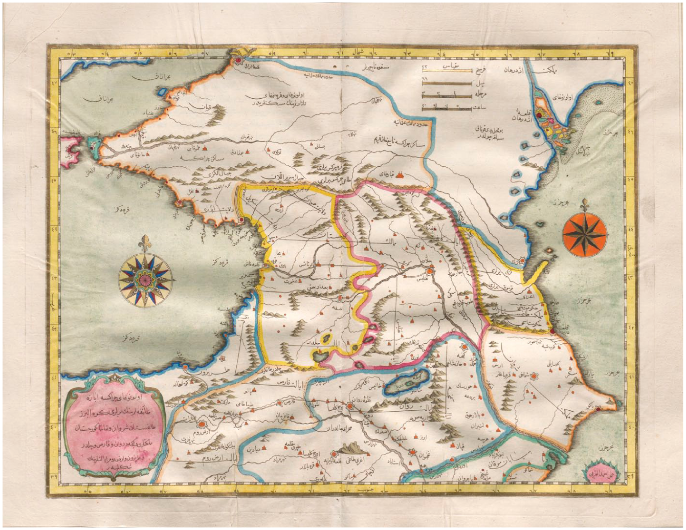
The meridian, salient here as a line that separates East and West, was also a key objective of frontier surveys sent to measure the empire’s southern rim. As Bakikhanov wrote in a manual for Muslim pupils, “A meridian is an imaginary line that crosses any place on Earth, passing from pole to pole.” 13 He was not far away when imperial surveyors measured the meridian (or local longitude) of Mt. Ararat, at the new extremity of Imperial Russian rule (Figure 1). The Russian astronomer Vasily Fedorov (1802–55) was specially trained and equipped for this task at the observatory in Dorpat (now Tartu) in the empire’s Baltic provinces. Part of a Baltic survey crew, Fedorov tilted his sextant up to the midday sun in late September 1829 to trace its “meridian passage” over Iran, across the south, and into Ottoman skies. 14 The sun’s highpoint, inferred from altitudes taken either side of its great arc, determined local noon, and with it the key to longitude. Four minutes and thirteen seconds after Fedorov’s noon, a Russian officer marked the meridian passage in Russian-occupied Bayburt, some 450 kilometers west, where Bakikhanov was also. 15 Bayburt marked the final action of the offensive. What’s more, Bakikhanov’s service in this final siege earned him passage to the Baltic provinces from which Fedorov came. This circuit inspired a new work of optics and enlightenment, Asrar al-Malakut or Secrets of the Heavenly Kingdom. 16 Its aim was to reposition European observational astronomy in the Islamic world.

(a) Map of the Caucasus ca. 1829 with (b) detail of the Ararat borderlands. Annotation by the author, based on “Lands between the Black and Caspian Seas” in Friedrich Parrot, Reise zum Ararat (Berlin, 1834).
The South Caucasus figures here not as a “contact zone” or “middle ground,” in the first instance, but as the scene of phenomenal contiguity and concurrence between distinctive territories of knowledge. 17 As a method, concurrence challenges standard views of non-European knowers either as informants, whose inclusion is premised on their “contribution” to Western science and inscription in colonial sources, or as mere vectors for the “diffusion” of that enterprise. 18 Moreover, concurrence insists on the synchronicity of different knowledges, in this case disrupting the tendency to engage Islamic-world sciences only as a premodern subject, and often as a precursor to European enlightenment. 19 Striking scenes from the Russian Imperial edge suggest an alternative view, as astronomers set up newfangled instruments in dozens of Sunni mosques around the Black Sea: sacred fieldsites equipped with their own regime of instrumentation, timekeeping, and widespread coordination in the spiritual geography of Islam. 20 Here, the marking of meridian transits vied with the astronomically determined adhan announcing the five Muslim prayer times. 21 Astronomers of Fedorov’s sort, meanwhile, appear out of place atop the minaret, disoriented in the cultural space they measured.
Such a reading, which sees European sources “surrounded by other voices,” is especially warranted where a state war so profoundly shaped the archive. 22 Surveys coordinated by the Imperial University in Dorpat were explicitly set against Islamic renewal, meant to measure the terrain of Caucasian resistance and the frontiers of Islamic empires. Then, as now, Europeans used the specter of “fanatical” Islam to justify policies of removal, ethnic cleansing, and terror: policies that would cease “only when the Cross is set up on all the mountains,” said one Russian commander. 23 That is precisely what Fedorov’s company did atop biblical Ararat in October 1829, operating from an Armenian monastery to sanctify their meridian measures. At once an Armenian homeland and a Kurdish pastoral heartland, the region was also inhabited by “Tatar” Muslims, Turks, Jews, Persians, and Nestorians besides. Fedorov’s measures were to define a new spatial reality for their “unmixing.” 24
His crew was sent from another imperial edge, the Baltic province of Livland, itself a unique borderland milieu where German sciences became widely coordinated across Eurasia in the service of the Russian Empire. 25 In the 1820s, the Dorpat Observatory emerged as Russia’s premier institution of astronomy and a regular training site for its Corps of Military Topographers. 26 This decade saw military surveyors and Baltic astronomers undertake to fix the greatest meridian arc of their age. Led by German astronomer Wilhelm Struve (1793–1864), the arc reached the Danube near the Black Sea at the longitude of Dorpat by mid-century. 27 The Ararat survey of 1829 followed this southerly trajectory, led by Friedrich Parrot (1791–1841), a Dorpat professor of physics and the son of the university’s first rector. The survey was martial in nature, involving Cossack soldiers and sharpshooters (Feldjäger) alongside university students. Parrot’s published account, moreover, was replete with “predatory Kurds” and Tatar “brigands,” resonating an imperial discourse that framed Russian aggression, perversely, as a defensive war against so-called “Caucasian savagery.” 28
This militant brand of Orientalism helps to explain the seeming isolation of such sciences – and the demand, accordingly, for a new kind of counter-history beyond “brokered worlds.” Parrot’s neglect of the local is distinct even among comparable survey enterprises in Africa, Asia, and the Americas, leaving little record of the Indigenous mediations and local information economies that itinerant European sciences routinely harvested and relied upon. 29 French and British colonial surveys were similarly defined in racialized opposition to eastern lands, yet they involved intensive engagement with the supposedly arrested Oriental sciences, as colonizers claimed to restore “material traces of past precision” in modern sciences. 30 In South Asia, far more than the South Caucasus, topographical surveys and colonial observatories enrolled local engineers and observers, while colonizers translated palm-leaf texts on timekeeping. 31 But whereas these regimes of measurement relied on mediation, Parrot attempted to obviate encounter with Caucasians, relying instead on Cossack soldiers’ “persuasion” of force. 32
The methodological argument here is for an alternative to models of encounter, mediation, and incorporation, a global history of science that would not only include extra-European knowledges when revealed in, or appropriated by, Western sources. Bakikhanov, an “Oriental translator,” certainly was a “go-between,” yet his Arabic and Persian publications and his itineraries through West Asian centers of power and learning point to a contiguous knowledge system that stands apart from the European frame. As Sarah Qidwai writes, the so-called Islamic sciences need not be “routed through Europe” to figure into larger narratives about the modern world. 33 Caucasian sciences of chronometry and astronavigation were as likely routed through Istanbul, Isfahan, and wider Islamic worlds beyond Russia’s borders.
This, in turn, reveals the degree to which surveyors’ tales obscure the fate of borderlands. Historians widely report the mapping of space and fixing of people as “the great act of modern state power,” though that power should not be taken for granted. 34 Surveyors figure as key protagonists in an apparently global process of enclosure whereby militarized states turned borderlands into “bordered lands.” 35 So, too, Russia’s nineteenth-century capture of the Caucasus posed new questions: would the isthmus between the Black and Caspian Seas be a colonial outpost of European empire – a buffer against Asia, according to Russian officialdom – or a porous interface of Eurasian worlds? In what follows, a history of science inclusive of Islamic enlightenment traces multiple trajectories of knowledge and culture across the borderland, even as a new regime claimed its closure. In three parts, I show how heavenly sciences traversed the Caucasian meridian, how sacred fieldsites straddled it, and how Bakikhanov sat Muslim readers in Dorpat-style observatories, revealing Quranic truths through refracting telescopes. Bakikhanov’s reach across the Ottoman and Qajar empires is a stark reminder that, in 1829, European surveyors stepped into a world of learning no less coordinated than their own.
Coordinating empire and Islam
Connectivity is precisely what the Russian Empire feared in the Caucasus and sought to replace with a new order of spatial control. 36 The Georgian Military Highway, built around the turn of the nineteenth century, dissected the mountains that ran from the Black Sea to the Caspian, seizing the longitudinal corridor to Tiflis. But even after the annexation of Eastern Georgia in 1801, Muslim polities retained control of the mountain north, with formidable anticolonial resistance in Circassia, Chechnya, and Dagestan. Russian sources targeted Islam as the backbone of resistance, believing Sufi teachers spread fanaticism among North Caucasian fighters and incited jihad. 37 But “holy war” was largely a tactical construct of Russian colonization, and a reflection of the imperial logic to extend the “dominion of Christendom,” as Parrot wrote, sighting Ararat as a “boundary-stone” (Markstein) against Islamic empires. 38 The movement of Muslim pilgrims and Sufi networks beyond those boundaries were a particular source of colonial anxiety. The persecution of suspected Sufi links in the 1820s, like the ban of the Hajj, reveals the Russian Empire’s hostility not simply to Islam but to its circuits. 39
Bent on reshaping the Caucasus, not as an interface but an outpost, Russian military leaders turned to survey sciences. 40 It was at this juncture that the Dorpat Observatory (built in 1810) emerged as a training ground for Russian military topographers and navy officers. 41 In 1811, a twenty-year-old Friedrich Parrot joined an expedition to Mt. Kazbek, overlooking the Georgian Military Highway. From its summit, he claimed to catch sight of the “sacred mountain,” Ararat, impossibly far to the south. 42 Keen was “the eye of a devout Christian,” and keenly aware of the empire’s designs. Dorpat’s ascendence coincided with considerable Russian annexations in the South Caucasus and around the Black Sea. The observatory’s acquisition of new optical and geodetic instruments under Struve’s directorship in the 1820s made the Baltic university town a privileged base for geographic intelligence in northern and central Eurasia. 43 Two missions thus set forth from Dorpat in 1829: one to Mt. Elbrus, in high Circassia, another to Mt. Ararat, at the very edge of the empire.
From Elbrus to Ararat, Baltic expeditions served an imperial project ostensibly meant to securitize the south as a barrier to Asia. 44 Orders for the Elbrus expedition came directly from the commander of the Caucasus Line, General Georgi Emmanuel, following a brutal punitive expedition against the Ottoman-allied Karachay people of the Elbrus Pass in late 1828. 45 At stake, said one Baltic physicist, was the Russian Empire’s exposure “to the people of Asia” by Circassian control of the mountain “passage” to the Black Sea. 46 South of the sea, surveyors consolidated Imperial Russian rule amid aggressive resettlement policies in the former Iranian khanates of Yerevan and Nakhichevan, renamed the Armenian Region (Armianskaia oblast’) in 1828. Parrot described traversing a “silent” land seemingly emptied of settled Persians and pastoral Kurds, who just three years earlier belonged to an 80 percent Muslim majority. 47 Surveys north and south were also linked by the war aim of severing Sunni links between Turks and Circassians.
Survey sciences thus enacted a highly militarized, anti-Islamic campaign of regional transformation. Even as Slavic and German settlers threatened the existence of Muslim pastoralists in the South Caucasus, colonial sources commonly attribute antagonism to “Islamic aggression.”
48
Imperial officials therefore saw demographic shifts, like the Kurdish flight from Yerevan, as the liberation of the region’s Armenian minority.
49
Pastoralists who passed through the newly demarcated Armenian Region now risked being “hunted” by armed settlers.
50
Parrot, however, peddled the familiar trope of a defensive war in opening his book Journey to Ararat (1834), blaming the Imperial Russian invasion on Kurdish “predations”: The imperial eagle then soared over Ararat; the pashalik of Bayezid [southwest of Ararat] was encircled, and the restless hordes displaced. The time had now come for the gratification of my dormant longing to behold this wondrous mountain, and an opportune moment set the means and ends of this journey evenly on the scale.
51
Implied is an analogy between Parrot’s, the surveyor’s, eye and that of the imperial eagle, two-headed on the Russian Imperial crest. It was to broadcast Baltic science at the fore of an aggrandizing colonial empire.
Such was the plan Parrot proposed to General Ivan Paskevich in 1828, dubbed “Yerevansky” for his conquest of Iran’s Yerevan and Nakhichevan khanates that year. Paskevich commanded an emergent bureau of Border Affairs (pogranichnye dela) in the south, and so outfitted the expedition with a detachment of two Don Cossacks and four sharpshooters. 52 Parrot and Fedorov, for their part, were armed with a royally purchased astronomical theodolite and sextant as well as a purpose-built pendulum clock for gravitational survey and precision timekeeping. That the treasury reimbursed Fedorov’s expenses, and even rewarded him with the theodolite, speaks to the premium placed on geographical data at imperial frontiers. 53 Parrot hoped to capitalize on this demand, writing with pointed imprecision about the “still entirely undetermined lands” of the South Caucasus. 54
Caucasians, however, knew well where they stood. The calculation of the five Muslim prayer times – a subject of considerable debate in northerly latitudes – demanded accurate geographical positioning, given seasonal variation in the length of days. 55 Hence the important office of a mosque’s muwaqqit, or time-keeper, skilled in solar and lunar sightings. 56 The science of chronometry was elevated to a distinct branch of Islamic astronomy, accounting for the bulk of the literature in medieval and early modern Arabic sources. 57 The rhythms of Islamic life also set the Caucasus in a wider, West Asian circulation of instruments and treatises dealing, for example, with lunar phases or the obliquity of the ecliptic. A telling work by an eighteenth-century mullah, Ali Efendi al-Daghestani, translated a Persian manual on the astrolabe, which models the heavens to reckon local time and latitude. 58 While Dagestan was the cultural nexus of Islam in the north, Karabakh’s literary center, Ganja, was an important conduit for Islamic sciences in the south, and not only for Muslims. 59 These links also nourished astro-sciences ensconced in Georgian and Armenian monasteries, as in a Tiflis court versed in Persian negotiations. 60 In Tbilisi today, a considerable astronomical archive shows Persian star charts kept among locally coordinated calendrical works and “moon books,” lunar eclipses being the customary method of finding longitude. 61
It is no surprise, then, that exquisite cartographies already sprawled across the Caucasus a century before Parrot’s survey. These maps also reflect multiethnic histories suppressed by later European cultures of measurement. One remarkable example comes from the Ottoman atlas Kitab-ı Cihannüma (Figure 2), printed in Istanbul in 1732. The art historian Ünver Rüstem notes that the atlas’s Baroque elements – the cartouche, the compass rose – “do not stop at pointing westward, but rather circle back to the Islamic context in which—and for which—the Cihānnümā was created.” 62 Indeed, the Caucasian plate was the work of a Crimean Tatar, Ahmed al-Kirimi, together with two Istanbul Armenians, Mıgırdıç Galatavi and Bedros Baronian. Galatavi and Baronian went on to devise an ingenious qibla-finder, capable of finding Mecca from nearly 400 points in the northern hemisphere. 63
The Caucasus by Ahmedü’l-Kırımi, Mıgırdıç Galatavi and Bedros Baronian, printed in the Ottoman atlas Kitab-ı Cihannüma by İbrahim Müteferrika (1732). The scale bar includes farsakh, Islamic miles, marhalah, and saet. Uppsala University Library, Bokband 1800-t.
A European source similarly testifies to Islamic enlightenments in the Caucasus, in this case routed into the Persian system of tributary empire. Joseph-Nicholas Delisle’s “General Map of Georgia and Armenia” (Figure 3) was printed in Paris in 1766 but “drawn from the maps, memoirs, measures, and observations of local people,” chiefly Georgian elites who moved through Persianate spheres of diplomacy. This is to say that by the time Europeans sought coordinates of the Caucasus, data was already forthcoming from Iran. Called to St. Petersburg by Tsar Peter I, Delisle sourced Caucasian coordinates from Georgian princes whose father, King Vakhtang VI, had himself translated Persian astronomical tables while in the Safavid capital of Isfahan in 1712–13. 64 Even the map’s longitudes are shifted some 10° east of contemporary examples, reflecting its basis, Delisle believed, in Vakhtang VI’s Persian tables and the meridian system laid down at Ulugh Beg’s observatory in fifteenth-century Samarkand. 65 The map’s Eurasian assembly is captured in a telling calibration between French and Persian units, with a scale bar in leagues and farsakh.

Georgia and Armenia by Joseph-Nicholas Delisle (Paris, 1766). The scale bar is in Parisian leagues and Persian farsakh. National Library of France, Département Cartes et plans, GE DD-2987 (6562 B): https://gallica.bnf.fr/ark:/12148/btv1b53052941z.r=Joseph-Nicolas%20Delisle?rk=85837;2.
This pluralism is all the more striking for its endurance under systems vassalage, rocked by successive wars between Ottoman and Iranian empires. Imperial Russian intervention, however, posed a distinct challenge to knowledge networks oriented toward Istanbul and Isfahan, or indeed to Mecca. The late eighteenth-century capture of coastal Dagestan accelerated the Russian Empire’s protracted colonization of the Caucasus. 66 The annexation of Georgia, siege of cultural centers like Ganja, and blockade of highland communities disrupted key nodes of connectivity. Slavic settlements had grown around militarized lines in the mountain north. 67 By 1829, General Paskevich and Finance Minister Georg von Cancrin – another key backer of Dorpat-based frontier sciences – schemed to realign the region as an export-oriented colony tethered to the northern metropole, in St. Petersburg. 68 At the same time, Paskevich’s military government began resettlement projects, with instructions to draw up separate Muslim and Christian districts. 69 These measures made Caucasian cartography, which cut across multiple axes, seem anachronistic in the new order. And yet, just as imperial policies often faltered on the ground, imperial surveys were neither so unique nor bounded as they claimed.
Conjunctions above and below
Baltic astronomers timed the empire’s aggression in the south with a series of conjunctions in the heavens, caused by variations in the moon’s orbital plane. An eighteen-year cycle sent the moon gliding across the Taurus constellation between 1829 and 1831, concealing select stars for discrete periods. The star Aldebaran, for example – brightest in “the Bull” – sits just below the ecliptic, where the moon dips for three-year cycles, not returning for another fifteen. 70 Astronomers looked on these conjunctions as the ticking of a celestial clock, finely tuned for navigation. At the observatory in Dorpat, Struve saw a “new method” of fixing longitude by sighting conjunctions from different sites. 71 The difference in local time could then be plotted east or west of the Dorpat Meridian, in terms of longitude. Thus, on October 15, 1829, Fedorov set up his one-meter achromatic telescope (Figure 4) in the Tatar village of Bayat, just beyond the clouds that clung to Ararat. By an art of optics, chronometers, and Cossacks, Fedorov clocked Aldebaran’s concealment behind the moon for one hour, nine minutes, and 50.18 seconds. 72 Turning these figures into a geographic position, however, required their transmission from one borderland to another.
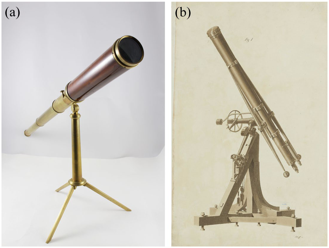
Left (a), a London-made telescope by Dollond of the model that Parrot and Fedorov used in 1829 (focal length: 1.1 m, aperture: 75 mm). Right (b), the Munich-made refractor by Fraunhofer (focal length: 4.3 m, aperture: 24 cm), installed in Dorpat in 1824. University of Tartu Museum, 241:1 AjKF.
A remarkable system of survey then took shape between the Baltic and Black Seas, linking observatories in Dorpat and Åbo (Turku) to occupied fieldsites in the Balkans, the Danube Delta, and Anatolia. Across the south, Struve’s trainees mobilized an array of instruments to replicate the operations of the Dorpat Observatory: to Dorpat’s new meridian circle corresponded Fedorov’s astronomical theodolite, acquired from the same Munich workshop, his telescope a portable likeness of the Fraunhofer refractor mounted high in Struve’s turret in 1824, the largest achromatic telescope to date at thirteen feet and seven inches (Figure 4). 73 In turn, Struve received thousands of measurements from over a hundred fieldsites in Serbia, Wallachia, Bulgaria, Anatolia, Armenia, and Georgia. 74 With a corps of calculators, he devised corrections for relative differences in the apparent width of the moon (reckoned by the duration of a star’s eclipse) and discrepancies in the instruments themselves (given their vastly different magnification powers). 75 By these means, Struve determined that the first eclipse of Aldebaran, in July 1829, occurred in Dorpat’s evening sky 30 minutes and 19.8 seconds earlier than in Ottoman Erzurum, recently fallen to Paskevich’s army. The lunar disc obscured Aldebaran again in September 1829, as seen from Edirne at the signing of the treaty between Tsar and Sultan. The Treaty of Edirne secured the Russian occupation of Moldavia and Wallachia, where military topographers observed conjunctions of Taurus and other ecliptic constellations (like Leo and Libra) into 1831. Converted into coordinates, these measures served a new cartography of encirclement around the Black Sea.
Struve’s tables also show conjunctions of a social kind: the meeting of distinct systems of celestial study. Over a third of observations west of the Black Sea were actually taken from Ottoman mosques, and usually from their minarets, as military topographers set up in at least thirty places of Muslim worship (to thirty-nine Christian ones). 76 This meant that surveyors climbed the very spires whence local Muslim’s heard the muezzin’s call to prayer five times a day, calls that were themselves astronomically determined. The Dorpat-trained surveyor Mikhail Vronchenko (1802–55), for example, ascended minarets burdened by his astronomical theodolite, magnetic dip needle, and chronometer. 77 And yet mosques were already coordinated, insofar as the qibla-wall and its prayer niches orient worshippers toward Mecca. 78
Yerevan’s Blue Mosque, for example, approximated the qibla by the local meridian, due south (Figure 5), much as observatories are oriented. Commissioned by the Shi‘a khan in the 1760s, the mosque was built after the Persian style, its prayer hall crowned by a blue-tiled dome and an off-set minaret. Worshippers approach from a great courtyard to face three delicately crafted prayer niches (or mihrabs) ensconced on the southerly qibla-wall (Figure 6). 79 The courtyard also housed a madrassa where some 200 pupils studied geography, astronomy, and mathematics alongside Islamic jurisprudence on the eve of Russian occupation in 1827. 80 In the 1840s, a German traveler observed a Persian-speaking class of thirty boys in the mosque who were dismissed “exactly at noon” by the adhan that marks the sun’s meridian passage. 81 Back across the Ottoman border, Sunni mosques of the period increasingly housed mechanical clocks. 82 This meant that muwaqqits used a combination of clocks and quadrants that resembled the techniques of European counterparts, like Vronchenko and Fedorov, who bore graduated arcs and chronometers of their own. Both enterprises were characterized by long-range coordination, no less important for the sacred geography of Islam than the spatialization of empire.
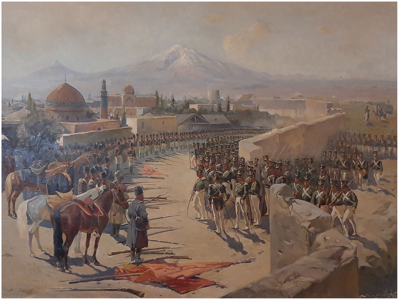
The dome and minaret of the Blue Mosque before Ararat during the Imperial Russian capture of Yerevan in October 1827, by Franz Roubaud (1893). History Museum of Armenia, Public Domain.
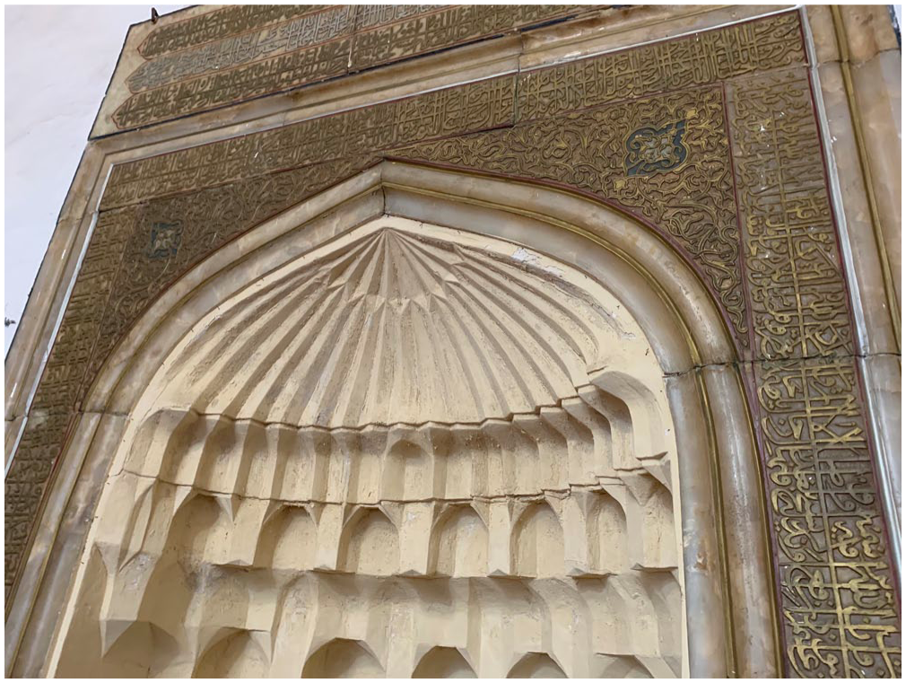
Center of three extant prayer niches in the Blue Mosque of Yerevan, built in 1765–6 by commission of Hoseyn Ali Khan in the Persian Yerevan Khanate. Photo by the author, January 2025.
The imperial coordination of mosques around 1829 raises questions about concurrence and encounter, which the sources of Dorpat science do not readily answer. 83 Even so, Fedorov’s records cast a kind of silhouette that gives a sense of survey science in sacred fieldsites, whether the minaret of a Bulgarian mosque or the belltower of a Georgian cathedral. Entering Tiflis in early June, Fedorov spent ten weeks fixing the geographic position of a Georgian cathedral – only to press Parrot for “another few weeks” to fix “a more precise determination of longitude.” 84 Fedorov worked within a culture of precision characterized by the relentless pursuit of mean values drawn from repeated observations. The plague that delayed their departure was therefore of little inconvenience to the astronomer. Reporting back to Dorpat, Parrot praised the “exemplary diligence” of Fedorov’s “daily” investigations of geographic position and local time. 85 By night, Fedorov shot altitudes of Polaris and meridian “culminations” of the moon, while by day, he took as many as sixteen noon sights (over 330 altogether). 86
These records project a striking image across the Black Sea, where Struve’s disciple Vronchenko took as many as eighteen lunar culminations from a minaret in Bulgarian Kavarna. 87 Imperial Russian military topographers likely occupied mosques in Bulgaria, Wallachia, and Rumelia for weeks, if not months, at a time, making repeated observations or awaiting cloudless skies and fortuitous conjunctions. Surveys of the sort could also have a profound material presence. Parrot pounded “sharp steel nails” into the stone walls of an Armenian monastery to auger his pendulum clock in place. After nearly two months stationed there, Fedorov took “two full days” to pack up his Reichenbach theodolite. 88 These time-stamps beg several questions about the mosque surveys and any exchanges that might have transpired during long hours of observation: What did Europeans make of the fact that mosques were already coordinated, instrumentalized, and even mechanized, if they noticed at all? 89 And how might muwaqqits, in turn, have appraised their counterparts’ regime of measurement?
Parrot’s account reflected the ethnic segregation in Paskevich’s resettlement plans and yet, in spite of himself, hinted at the region’s Muslim geography. To the university in Dorpat, Parrot reported Paskevich’s “victory against the enemy of the Fatherland” and heralded Armenia’s liberation from the “shackles of Oriental despotism.” 90 This, after sourcing route plans from Mehmet Bahaliihl (sic.), a Kurdish prisoner kept in Tiflis. Bahaliihl governed the same Ottoman “pashalik of Bayazid” whose capture Parrot symbolized in the soaring of the imperial eagle over Ararat. 91 Only in his carceral state did the Kurdish lord appear an intriguing and useful intermediary to Parrot. Parrot apparently encountered him in prayer, “kneeling upon a carpet facing the corner of the room, still and zealous.” 92 The line blurred between mediation and interrogation as Parrot’s company returned on several occasions. They were especially keen to source a route-plan up Ararat from the prisoner, whose father once attempted the ascent. 93 Bahaliihl, for his part, reportedly spent several evenings “observing the starry heavens” with Fedorov’s telescope. He was even said to provide a letter securing them safe passage to Bayazid – some fifteen kilometers from the foot of Ararat – which he proposed as a headquarters for their survey. The company never made it to Bayazid (now Doğubayazıt), ostensibly because of the Kurdish threat, or perhaps because of the city’s well-documented obliteration at the hands of Imperial Russian artillery. 94 Instead, they traveled to the seat of the Armenian Church at Etchmiadzin, north of Ararat, and from there to the Saint Hakob monastery on its northeastern slope.
The ethnic basis of Parrot’s maneuvers in the region reflected a new order of direct governance, no longer mediated across religious or sectarian lines. Kurds and Armenians alike had negotiated relative autonomy at the margins of Ottoman and Qajar rule by carving out what Sabri Ateş calls “alternative state-spaces” in the century before Russian Imperial intervention. 95 Crown Prince Abbas Mirza, who led Iranian forces against Paskevich, recognized the “Caliph of the Armenian Nation” under Islamic law, a status earned through the Church’s own program of cadastral survey. 96 In other words, it was never a foregone conclusion that Caucasians would align with their co-religionists, contrary to Parrot’s assumptions. By his own admission, Armenian leaders in Etchmiadzin were skeptical of his proposed ascent of Ararat, much as local Christians were divided in their attitude to the new Russian occupier. 97 This put the Dorpat crew on a precarious footing, all the more dependent on their Armenian hosts for having dismissed a possible alliance with local Kurds. Their most important local ally proved to be the deacon Khachatur Abovian (1809–48), a Russophile intellectual who followed Parrot back to Dorpat for a European education. But Abovian was “indispensable” precisely because he spoke the South Caucasian languages: Tatar, Eastern Armenian, and Persian. 98 Tatar-speaking Cossacks, meanwhile, requisitioned local Muslims’ homes for Fedorov’s survey in the plain, “persuading” Tatars also with a show of force. 99 The Ararat survey thus operated through a blend of force and mediation that reflected a borderland under strain.
That same blend was embodied in the figure of Bakikhanov, who was a military translator after all. At Paskevich’s side, Bakikhanov brokered the annexation of Yerevan from Iran’s Abbas Mirza before joining the Imperial Russian campaign in Ottoman lands. The campaign ended in October 1829, just as Parrot’s company completed their operations around Ararat. The two crossed paths in Tiflis shortly thereafter, as a conjunction in the skies over the colonial capital. Parrot needed “Major Abbas Kuli [sic.]” for a calendrical task: to date Tatar “tombs” found high on Ararat, of which Abovian made rubbings. For this, Bakikhanov converted the tenth month of the 650th year of the Hijri lunar calendar to the Gregorian solar calendar, in the year 1292. Additional corrections were required for the specific “reckoning of the Turks,” which reconciled the twelve lunar months with the solar year. 100 Parrot gave the episode short shrift, perhaps because it set Muslim worship on the same “hallowed mountain” as a Christian monastery. But it was enough to reveal the invocation of prayer that Bakikhanov deciphered on weather-worn stone: “Oh Allah, peace be upon the Prophet Muhammad,” it began. It was an apt task for the Shi‘a officer, who renovated the region’s links to the wider Muslim world.
Persianate scribes and Islamic Newtonianism
Bakikhanov traces a distinct orientation of survey sciences at the limits of Russian Imperial rule. Here, survey projects born of European power were set into existing patterns of cultural production, especially in the hands of princely Shi‘a scribes who salvaged their status by cooperating with colonizers. 101 Colonial governance depended essentially on this class, unable to overhaul tax revenue systems and territorial divisions in former khanates. The first “Russian” surveys in the early 1820s rather co-opted the divan system of Iranian bureaucracy and enrolled its scribes to translate weights and measures, deeds, and of course Hijri dates. 102 Successive Russian annexations – Shirvan (1820), Karabagh (1822), Yerevan and Nakhichevan (1828) – not only demanded geographical intelligence at scale; these land grabs also required a workforce of servitors for ethnographic and statistical survey.
Colonial transition thus set in motion multiple processes, which simultaneously incorporated Persianate elites and alienated rural Muslims amid an influx of European settlers. 103 Statistical survey of the new Armenian Region followed Fedorov’s geodetic program in 1829, codifying subjects into two crude categories: Armenian or Muslim. 104 Meanwhile, Paskevich’s committee on resettlement organized the transfer of tens of thousands of Ottoman and Persian Armenians into the new South Caucasian colony. 105 But even as ethno-religious lines hardened, some bureaucracies persisted in the Persian language into the 1840s, defying official Russification policies. 106 What’s more, Russian officials encouraged the circulation of Persian print culture in the empire. The ignorance of the occupying power, headed by Russian and Baltic nobility, put ethnographic information and historical surveys in high demand. In answer, Tatar nobles like Bakikhanov, Mirza-Jafar Topchubashev (1790–1869), and Mirza Kazem-beg (1802–70) carved out a space of Orientalist expertise in imperial universities and government ministries. 107 Yet this work was not merely answerable to European empire. Notably, works like Bakikhanov’s Golestan-e Eram (1845), a history of Shirvan and Daghestan, were published in Persian, and not necessarily translated to Russian. 108 In form and style, too, these Caucasians wrote in the conventions of the Persian court, even as they addressed governors in Tiflis. 109
Persian chronicles thus come into sharp relief against the cruder Orientalism of travelers like Parrot, though they served the same Tsar. Take Mirza Adigözal Beg (1780s–1848), a native of Karabakh and a spy and clerk in the Imperial Russian military. Adigözal’s history of the region is nonetheless framed by Quranic verses and Persian couplets. His account of the battle for Yerevan, moreover, mourned a conflict that “turned the world dark” as a kind of solar eclipse. “The two armies met at Etchmiadzin,” he recalled: “The dust from the horses’ hooves darkened the stars. The blaze of sabers covered the rays of the sun in the vault of heaven.” 110 It was a striking lament from within the colonial discourse, and a marked contrast to Parrot’s triumphalism. Where Adigözal wrote further of “red blossoms” sprouting from rivers of blood, Parrot described the same soil “infested” with Kurds and other “Mohammedans,” at least until “the armies of the Crescent and of the Cross were drawn up before Ararat,” at the imagined edge of Europe and Asia. 111
If Adigözal and Bakikhanov served European empire, their insistence on Persian prose and Islamic genres also maintained a distinct trajectory of Caucasian culture. Beyond “brokering” European power in the region, Bakikhanov was a “border subject” in Madina Tlostanova’s sense of the term, concerned with “re-linking” Caucasian Muslims with cultural systems in West Asia. 112 In 1831, Bakikhanov served Imperial Russia’s campaign against a Daghestani resistance that set Islamic law against alien occupation. His proposal for a Muslim School in Tiflis the next year reads as an inverse reflection of northern resistance: the preservation of “Muslim law in its purity” was a tenant of the school, which was to specialize in Arabic and Persian. 113 Arabic, the language of Islamic jurisprudence, should forge new links to the mountain north. Echoing the “Asiatic Schools” that produced imperial translators on the Central Asian steppe, Bakikhanov’s Muslim School would supply agents for “communication with the mountaineers” of Dagestan, Chechnya, and Circassia. 114 It was Persian, though, that should set the school in wider Asian circulation, as the “written language” that links “our region” to “the greater part of Asia,” Bakikhanov wrote. 115 The project’s swift rejection by the governor of the Caucasus is a reminder that Bakikhanov remained exterior to empire. 116
It follows that Muslim reformers in the Russian Empire were not merely responding to “the challenge of the West,” as Adeeb Khalid cautions. Whether in Tiflis or Tashkent, Muslim cultural reforms “were not directed solely at the colonizer.” 117 Instead, the Persianate discourse in the Russian Caucasus shows Bakikhanov selectively positioning aspects of European culture in Asia, what he called “the most extensive and the very best region,” in a work for Muslim students of astronomy and geography. 118 His book Asrar al-Malakut (completed in 1839) stemmed from a two-year mission to sites of learning in the Russian Empire’s western borderlands in 1833–5, including a visit to the birthplace of astronomer Nicolaus Copernicus. He probably also visited the observatory in Dorpat, where Abovian studied from 1830 to 1836. Bakikhanov, for his part, returned to Tiflis convinced of a symmetry between European science and Quranic study, and he saw astronomy as an interface between them.
Though generally regarded as a “Copernican” treatise on the sun-centered universe, Asrar al-Malakut was more specifically devoted to the observational regime practiced in places like Dorpat. 119 A discourse on the meridian in practical astronomy was followed by a table of planetary dynamics (Figure 7). Significantly, this included recent telescopic discoveries of Vesta, Juno, Ceres, and Pallas, as well as Uranus and its six known satellites. Bakikhanov called it al-Herschel (الهرشل) after its British discoverer William Herschel (1738–1822). Persianate readers of Asrar, or its later Arabic or Turkish translations, found themselves seated in a Herschel- or Struve-style observatory, using spectacular telescopes to make “precise observations” of newly revealed heavenly bodies – their distance from the sun, the length of their days and years, even the sight of their “mountains, deserts, and fires.” 120 Asrar was, in short, a celestial survey. The moon appeared as if in topographical “relief maps, determining the height of the mountains, width of valleys and depressions, and area of deserts.” 121 Here, Asrar alluded to the Mappa Selenographica produced by Berlin astronomer Johann Heinrich Mädler in the years of Bakikhanov’s north European travels. Mädler replaced Struve as head of the Dorpat Observatory at the end of the decade, turning its Fraunhofer refractor to lunar survey. 122

Table from the Arabic translation of Bakikhanov’s Asrar al-Malakut, listing the distance from the sun, period of orbit (year-length), period of rotation (day-length), and diameter for thirteen heavenly bodies. Islamic Consultative Assembly, Museum, and Documentation Center, Tehran, Public Domain.
If Bakikhanov sat Muslim readers in European observatories, he also read Newtonian cosmology in the Quran and the hadith. Newton’s Principia mathematica (1687) was translated into Arabic in Bengal in 1789, and its mechanics were implicit in Persian artillery handbooks of the period. 123 But Asrar was a novel theoretical treatment of Newtonian cosmology in West Asia. It ranged from the Earth’s tides and oblate figure to secular variations in its axial tilt. Here, Newton’s theory of gravity figures as a bridge between the European regime of observation and the knowledge of the Prophet Muhammad. Viewing the Sun among countless stars, all rotating around “some great center,” Bakikhanov returned to the celestial lamps of Quranic verse: “He inspired each sky with his work, and We adorned the nearest sky with lamps and for protection” (Surah Fussilat 41:12). 124 In Asrar, these verses were theory-laden: skies are solar systems, he argued, lamps their planets, and “by ‘protection’ is meant universal gravitation, on which the order of worlds is based.” That the Quranic “sun flows to its abode” was further evidence, Bakikhanov believed, that the Prophet perceived the sun’s orbit in space, subject to the “universal gravity connecting all bodies” instantly and without mediation. 125
In Simon Schaffer’s classic analysis, Newton’s theory of “action at distance” makes for a poignant analogy to the colonial information order on which he relied. 126 Even from a place of relative seclusion and immobility in England, Newton himself seemed to act at great distances by drawing data on tides, pendulums, comets, and satellites from aggressive European trading ventures in the East and West Indies. I suggest the theory of action at a distance took on a distinct meaning at the edge of Europe and Asia, in the hands of the “border subject” Bakikhanov. Russia’s Persianate scribes translated between different solar and lunar calendars, courts of Islamic and Romanov law, and revelations of Prophetic and telescopic kinds. Islamic Newtonianism had purchase, therefore, in a Persianate sphere that also connected seemingly remote “worlds.” Crucially, though, this kind of mediation was not designed to serve European empire, nor simply to “diffuse” European science. Rather, Asrar attempted something far more radical: a repositioning of survey sciences within ongoing projects of Islamic renewal, routed first into Persian then Arabic and Turkish worlds of learning. To act at a distance from the Caucasian borderland was to reveal the concurrence of European and Asian projects in astronomy and geography in the nineteenth century.
Re-Orienting the history of science
Lifting his eyes to the stars, and seeing the Pleiades had already risen half way up the sky, Hadji Murád calculated that it must be long past midnight, and that his nightly prayer was long overdue.
127
Leo Tolstoy, Hadji Murád
Baltic surveys of the Caucasian meridian reveal a great deal about the relationship between lines drawn on the land and lines drawn between people. Parrot’s account played up ethno-religious enmity amid colonial resettlement and segregation, discoursing on human difference to underwrite Fedorov’s demarcations on the ground. But surveyors’ tales of difference and demarcation severely obscure the extent to which European sciences were “surrounded by other voices.” 128 The Caucasus was, and remains, a “mountain of tongues,” in the words of an Arab geographer. 129 Hence the significance of polyglots like Bakikhanov to borderland diplomacy, and of Abovian (if not Bahaliihl) to survey in a land of Armenians, Kurds, Turks, and Tatars. And yet mediation is not the only proof of plurality. Where cultural translation is rendered obscure in European sources, alternative records testify to the concurrence of widely networked knowledge systems: in the vast coordination of Islamic cartographies, from Istanbul to Isfahan, and in the sacred architecture that links mosques to Mecca.
At stake in the concurrence of these projects is a global history of science better equipped to counter the epistemic violence visited on the non-European world in general and the Islamic world in particular. An existing tool-kit of contact zones, brokers, and go-betweens has ambitiously multiplied the number and kind of actors involved in the making of putatively European sciences. 130 But emphasis on intercultural translation faces limits for the same reason, with informants and brokers ultimately enrolled in European developments, when they appear at all. 131 What makes Bakikhanov so analytically compelling is the fact that he was both enrolled in and exterior to European empire, increasingly active in an Islamic world of science possessed of its own historical integrity and adaptive power and thus engaged in a shared (if differentiated) “colonial modernity” in Eurasia. 132
In the Caucasian case, concurrence interrupts a broad imperial ideology of conquest, which claimed to remake the region as a colonial outpost – the frontier of “Christendom” – rather than a Eurasian interface. A particular European fetish for tales of Caucasian resistance (coded as “savagery”) reveals what Susan Layton calls the “real imperial bestiality” of Russian Orientalism. Frontier fiction was mobilized, like frontier science, for the mythology of a “defensive warfare against Asian barbarism.” 133 Against that consensus, Tolstoy’s posthumous Hadji Murád (published in 1912) is a rare dissenting voice, written in the mode of concurrence. The novella sets the titular Murád (1818–52), an Avar commander, against the drunken aggression of the Russian Imperial forces Tolstoy served in the early 1850s. In fact, Murád is introduced “calculating” prayer time by the altitude of the Pleiades, in the constellation of Taurus. In Tolstoy’s telling, timekeeping registers Murád’s movement across Russian and Caucasian lines. Noting Murád’s keen sense for chronometry, a Russian commander gives him a mechanical repeater watch. Murád is impressed by the mechanism, not as a novelty, significantly, but as an instrument of worship: “enough! It is time for me to pray,” Murád says, resetting the repeater’s spring after it struck quarter past twelve. 134 If the watch figures as a symbol of European modernity, this has no self-evident significance in Tolstoy’s Caucasus. Like Newtonian mechanics in Bakikhanov’s Asrar, the watch mattered insofar as it was appropriated for precision prayer.
Even as an anticolonial fable, the scene hints at histories of science that spring from Eurasian borderlands, defying the lines drawn by surveyors. Lines of the North Caucasus, Tolstoy knew, were blurred by settlers’ economic dependence on local trade and intermarriage between Slavs and so-called “mountaineers.” 135 While Caucasians like Bakikhanov made careers as translators in the Russian military, Russian soldiers deserted by the hundreds to the highland redoubts of the Indigenous resistance. 136 Even the genocide of Circassians in the 1850s and 60s – the killing of least 625,000 people and expulsion of many more – produced new frontier societies, but rarely a Russian majority. 137 Fitful demographic change in the south brought its own instability. Muslims and Christians alike complained about disproportionate land grants that officials in Tiflis awarded to European settlers. 138 In the Armenian Region, Russian Imperial policy moved to “neutralize” the political power of Etchmiadzin “far more than the Persians had ever attempted,” thus circumscribing Armenia’s promised liberation. 139 Lines neatly drawn were rarely kept. Some Armenians even returned to their homes in Islamic empires.
To read across those lines is to trace the concurrent trajectories of knowledge and culture at the Caucasian meridian. Far from an inexorable global process of frontier enclosure, the new order assailed and sometimes realigned, but did not displace, Eur/Asian circuits. As encounters with empire sent some Caucasians to Baltic centers of learning, so Iran’s defeat at the hands of the Russian military propelled Persians to study physics and engineering in Europe, returning home to launch distinctively Eurasian programs of frontier survey. 140 In many ways, the ascendence of Dorpat’s program in long-range astronomy was mirrored by new schools of military engineering and navigation in Istanbul and Tehran, staffed by Europeans and Asians. Heliocentric works of astronavigation circulated among Ottoman naval cadets in the early 1830s, just as Newtonian concepts of mass, force, and gravity appear in handbooks for Qajar artillery officers. 141 In Dorpat, meanwhile, Struve and Fedorov processed reams of data from Ottoman and Iranian lands, imminently useful to Russian Imperial military cartographers.
It was at this moment that Bakikhanov had “contact with the leading scholars of Europe,” as he said, then re-routed European science into Islamic enlightenment.
142
In Shi‘a fashion, his brief account of travels ended with the words of Imam Ali, companion to the Prophet Muhammad: The ignorant and their deeds are many They are not equal to the people of science and literature If dogs are dressed in golden fabrics They are not like a lion that is devoid of gold.
143
The lion devoid of gold tracks well with the colonial intellectual who remained a marked Muslim “other.” Bakikhanov’s position of exteriority was emphasized again upon returning to Tiflis. The Baltic general who now ruled as de facto viceroy of the Caucasus, Baron von Rosen, interrogated Bakikhanov on suspicion of involvement in anticolonial resistance. Like Bahaliihl before him, Bakikhanov was imprisoned for a time in Tiflis, before returning to an uneasy military service at the edge of the empire. Yet the imperial edge remained a space of friction and movement, particularly through Muslim networks.
It was along the pilgrimage route to Mecca, in fact, that Asrar al-Malakut had its widest circulation. Certainly, Bakikhanov’s heavenly mechanics were meant to make a space for Islam in the cultural framework of the European empire he had long served, as much as his grammar manuals and school projects. 144 But Asrar also appropriated European survey sciences for ongoing projects of Islamic renewal and exchange across the Persianate and Ottoman worlds. Asrar’s circulation on the Hajj testifies to those trajectories, far beyond the bounds of Imperial Russian rule and the sight of its surveyors. Unable to keep Caucasians from going on pilgrimage, colonial officials in Tiflis began to issue passports in an effort to surveil the Islamic networks they deemed a “security threat.” 145 Bakikhanov received his passport in 1845. The next year, he traveled with a company of Caucasian writers first through Iran then to Istanbul, where he presented Asrar to the Ottoman Sultan, and finally to Mecca via Cairo. Though Bakikhanov died shortly after reaching Mecca, Asrar was soon translated into Turkish and survives as an Arabic manuscript in Tehran, chosen as the Qajar capital (see Figure 7).
As an outpost of European empire, the Caucasus was coordinated in places like the Dorpat Observatory and its successor in Pulkovo near St. Petersburg; the region was measured and mapped by the armed astronomers and military topographers. Even under the strain of colonial transition, though, Bakikhanov’s itineraries suggest the maintenance of older links to centers of power, learning, and worship coordinated across West Asia. It has been the aim of this article to set those systems in juxtaposition, alive to moments of transgression and symmetry between them, perhaps most remarkably in the Sunni mosques that served as Russian observatories. To assert their concurrence is to resist the oppression of the one over the other and defy claims to domination and purity, ethnic or scientific.
Footnotes
Acknowledgements
I am extremely grateful to Dana Beltaji and Shahd Waleed Almodallal for discussion of Arabic sources. I thank the History Hash Out (organized by Hanan Kholoussy) at the American University in Cairo and the Higher Seminar (organized by Hanna Hodacs) of the Department of History of Science and Ideas at Uppsala University for their critique and encouragement, with particular debt to Arvid Sjödin, Maria Florutau, Linda Andersson Burnett, Petter Hellström, and Anna Svenson. Special thanks to Catherine Gibson for bringing rigor and care to this article and to the special issue as a whole.
Declaration of conflicting interests
The author declared no potential conflicts of interest with respect to the research, authorship, and/or publication of this article.
Funding
The author disclosed receipt of the following financial support for the research, authorship, and/or publication of this article: Irish Research Council Postdoctoral Fellowship (GOIPD/2023/1098), Marie Skłodowska-Curie Action, Project 101106896, AnthroFront.
Notes
Author biography
Patrick Anthony is the author of the book Unearthed: Science and Environment Across Mineral Frontiers (The University of Chicago Press, 2026), which tells the story of how early environmental sciences laid the groundwork for global extractivism in the nineteenth century. He currently leads the EU-funded project “Anthropocene Frontiers: Colonial Climate Science in Siberia and Central Asia.”