



Abstract
Some of the increasingly evident contradictions between spatial planning and social policy in Mexico City are apparent in the way land use regulation folds into and articulates with exclusion and marginality. In downtown areas, regulatory approvals and various planning measures have facilitated the escalation of land and housing prices and more exclusionary forms of urban development. At the periphery, land use regulation now conditions access to urban services, property titles, and even some social programs for settlement areas designated as “informal.” Comparing the state’s role in planning at these distinct sites uncovers a pattern of selective and uneven spatial regulation in different socioeconomic territories of the city, characterized by “fast-track” development approvals in downtown areas and “slow-track” regularization of settlements in peripheral areas. The analysis suggests how this pattern of uneven spatial regulation contributes to (re)producing urban space in ways that call into question the local government’s stated support for the “right to the city.”
Las geografías desiguales de la regulación espacial ponen de manifiesto algunas de las contradicciones cada vez más evidentes entre la planificación espacial y la política social en la Ciudad de México. En las áreas del centro, las aprobaciones regulatorias y varias medidas de planificación han facilitado el aumento de los precios de la tierra y la vivienda y formas más excluyentes de desarrollo urbano. En la periferia, la regulación del uso de la tierra ahora condiciona el acceso a servicios urbanos, títulos de propiedad e incluso algunos programas sociales para áreas de asentamiento designadas como “informales.” Comparar el papel del estado en la planificación en estos sitios distintos revela un patrón de regulación espacial selectiva y desigual en diferentes territorios socioeconómicos de la ciudad, caracterizados por aprobaciones “fast-track” de desarrollo en áreas del centro y regularización “slow-track” de asentamientos en áreas periféricas. El análisis se centra en cómo la regulación del uso de la tierra se enreda y articula con la exclusión y la marginalidad y cómo la regulación espacial desigual contribuye a (re) producir espacio urbano de manera que cuestione el apoyo declarado del gobierno local por “el derecho a la ciudad.”
Since the restoration of local elections in 1997, the Mexico City government has received kudos for initiating a range of new social programs. Introduced by local governments led by the Partido de la Revolución Democrática (Revolutionary Democratic Party—PRD), these programs have supported community kitchens, school uniforms, a food pension for seniors, and upgrading in marginalized communities, among other initiatives. 1 These programs have been recognized for their attention to citizen participation and vulnerable social groups, with some receiving international awards. 2 The progressive bent of these and other urban policies has featured prominently in the way each new local administration has promoted itself: A City for All (1997–2000), the Equitable City and the City of Hope (2000–2006), Vanguard City and City in Movement (2006–2012), and Let’s Decide Together and Social Capital (2012–2018). As these slogans suggest, these policies have been integral to the political branding of the city’s PRD-led governments (1997–2018).
The city’s progressive policy bent is also visible in the Mexico City Charter for the Right to the City, a proclamation signed by Mayor Marcelo Ebrard Casaubón (2006–2012) in a downtown Mexico City theater in July 2010. The charter embraces several strategic directions for enhancing urban and community life in the city, such as the right of residents to participate in decisions concerning the planning and production of urban space (Wigle and Zárate, 2010). The charter also affirms the “social function of the city, of land, and of property” (Comité Promotor, 2010: 11),
3
defined as the distribution and regulation of the use of territory and the equitable usufruct of the commons, services, and opportunities offered by the city, prioritizing the collectively defined public interest. Its objective consists of guaranteeing the right of all persons to a safe place in which to live in peace and with dignity through the generation of participative spaces and instruments to reduce and control speculation, urban segregation, exclusion, and forced evictions and displacements.
This concept is integral to the city’s commitment to the “right to the city,” now incorporated into the Mexico City Constitution (CDMX 2017a). Beyond the kudos and signed declarations, however, actual urban development patterns warrant closer scrutiny given their implications for exclusion and marginality. This task is taken up here by examining the impacts of the city’s uneven geographies of spatial regulation.
In many cities, spatial planning and social programs are operationalized through different agencies and treated as separate policy realms. Mexico City is no exception, with its different agencies and programs for housing, social development, and urban planning. For example, the Instituto de Vivienda (Housing Institute—INVI) is charged with managing the city’s affordable housing programs, including the Programa de Mejoramiento de Vivienda (Housing Improvement Program—PMV). The PMV addresses housing problems related to overcrowding, precarious or dilapidated conditions, and risk-prone locations (CDMX, 2017b: 508). 4 The program matches small, interest-free loans with technical expertise and participatory design to upgrade housing conditions at the lot scale, principally for low-income households. The Secretaría de Inclusión y Bienestar Social (Inclusion and Social Well-Being Secretariat—SIBISO) oversees the Programa Mejoramiento Barrial y Comunitario (Community Neighborhood Improvement Program—PMByC). The goal of the PMByC is to “rescue and improve public spaces and social infrastructure in neighborhoods, barrios, and towns . . . through a participative, integrated, and inclusive process supported by and with gender equity” (CDMX, 2017c: 200). Operational guidelines specify that areas with higher levels of marginality should be prioritized in resource allocation decisions (CDMX, 2017c). 5 For both the PMV and the PMByC, however, housing lots and communities deemed to be “informal” or “irregular” are not eligible for program support, thereby excluding some of the most marginalized areas of the city. 6
While these housing and neighborhood improvement programs target resources toward marginalized areas and social groups, market-oriented urban development processes forge ahead in reshaping the broader socio-spatial structure of the city, under the direction of the Secretaría de Desarrollo Urbano y Vivienda (Urban Development and Housing Secretariat—SEDUVI), the agency responsible for zoning, land use permissions, and strategic planning directions. One of these directions includes the pursuit of a more compact and densely populated downtown core through a series of interrelated urban interventions that have produced a more exclusionary and exclusive central area over time (Delgadillo, 2016a; 2018). 7 The resulting displacements are multiple, including the relocation of informal vendors (Crossa, 2009) and the market-led displacement of lower-income households from centrally located housing (Delgadillo, 2017; Walker, 2013). For those displaced, the subsequent search for affordable housing will likely take them to more peripheral areas in Mexico City or even to the distant metropolitan periphery (Delgadillo, 2018), effectively relocating residents from Mexico City to areas with disadvantaged access to public transportation, urban services, community amenities, and formal employment (Suárez, Murata, and Delgado, 2016). 8 These concurrent urban development trajectories of “compact city” and “dispersed periphery” (Pradilla Cobos, 2015) suggest some of the impacts of uneven spatial regulation in Mexico City.
This paper examines the land-use-regulation–social-policy nexus in two socioeconomic territories of Mexico City integral to the “compact city” and “dispersed periphery” trajectories: the downtown core and the southern periphery. 9 Using this comparative lens, the analysis highlights how the city government deploys land use and spatial regulation in ways that reflect power relations and reinforce urban fragmentation. For example, the 55-story Torre Mayor project (1999–2003) developed by an international real estate firm on the iconic downtown Paseo de la Reforma exceeded the zoning height limit of 25 floors in the urban development plan and was granted a five-year amnesty from paying local property taxes (Parnreiter, 2011; 2015). Two years after the Torre Mayor was completed, the city began to introduce a new approach for managing “irregular” or “informal” settlements in the conservation zone of southern Mexico City, proposing that residents pay fines for damaging environmental services as part of their “regularization” (the state-defined process for securing land use permissions, urban services, and property titles in new settlement areas) (GDF, 2005; Wigle, 2014). While alterations or violations of zoning or building codes for downtown real estate projects are likely worked out through “backdoor” negotiations (Aguayo, 2014), the regularization of informal settlements usually involves protracted state-community negotiations with uncertain outcomes (Connolly and Wigle, 2017). Comparing the state’s roles in planning and urban development at these distinct sites uncovers the uneven geographies of spatial regulation in different socioeconomic territories of the city, characterized by “fast-track” development approvals in more affluent downtown areas and “slow-track” regularization of lower-income communities in peripheral areas. This comparative analysis raises critical questions about the political uses of informality in planning and development processes (Connolly and Wigle, 2017; Müller and Segura, 2016) and the local government’s stated support for the “social function of the city, of land, and of property” and a more “equitable, inclusive, and compact” city, as highlighted in various city planning and policy documents. Indeed, a more critical register of the Mexico City government’s record emerges through this comparative examination of spatial regulation at these different sites. The paper focuses on the period from 2000 to 2017 and draws upon the academic literature, policy documents, and media coverage to show not only the differential regulation of urban space but also the relational nature of core-periphery urban areas in (re)producing patterns of exclusion and marginalization.
Regularization as Spatial Regulation
Although sometimes depicted in simplistic terms as a monolithic mega-city, Mexico City is a complex urban landscape constituted by “interactive formal and informal [development] modalities that are produced by and, in turn, reproduce material and social precarization” (Gilbert, Khosla, and de Jong, 2016: 17). A comprehensive study of settlement typologies in Mexico City identifies 10 categories of settlement type distinguished by location, social class, housing type, and histories of land and the production of urban space (see Connolly, 2005; Connolly and Castro, 2016). In Mexico City, one of the most pervasive settlement types is the colonia popular, a working-class neighborhood produced through incremental, mostly resident-led processes of constructing housing and urban services over time. Most colonias populares begin as asentamientos irregulares (irregular settlements), new settlement areas generally built without credit in a progressive fashion as household resources are available to invest in the housing construction and consolidation process (Connolly, 2003). Connolly and Castro (2016) estimate that approximately 60 percent of housing and urban space in Mexico City has been produced in this manner, mostly by lower-income households that cannot afford to acquire housing as a finished product located on serviced land. The prevalence of colonias populares is also the result of state housing policies that fail to provide affordable housing options (Duhau and Cruz, 2006; Gilbert and de Jong, 2015). Paradoxically referred to as “irregular” despite its prevalence, this predominant mode of housing production (Connolly, 2009) is said to be “regularized” over time through the extension of land use permissions, urban services, and property titles. In most cases, regularization involves prolonged state-community negotiations during which residents live under precarious conditions (Duhau and Schteingart, 1997). The regularization of informal/irregular settlements tends to relate to the clientelistic practices of the Mexican state (Azuela and Meneses-Reyes, 2014; Varley, 1996) rather than to community needs (Ward, 1998). In general, these new settlement areas form on the periphery of the built-up city or on the edges of outlying rural towns in the metropolitan periphery, where unserviced land is cheaper and community amenities are in short supply, at least initially. Without the threat of eviction, many of these settlement areas evolve into heterogeneous, mixed-use communities (Angotti, 2013a; Connolly, 2003). Most of the eastern and southeastern periphery of Mexico City has been urbanized in this way, reinforcing longstanding patterns of socio-spatial segregation (Rubalcava and Schteingart, 2000).
Although these processes of so-called informal urbanization take place in peripheral areas and at the “margin of urban norms” (Duhau and Cruz, 2006: 400), they are also deeply embedded in state policies and planning practices. In Mexico City, the state is involved in the material production of informality through “policy-led precarization” (Gilbert, Khosla, and de Jong, 2016: 16), the construction of informality through its discursive framing in urban plans, programs, and norms (Azuela, 1997; Connolly, 2007; Connolly and Wigle, 2017; Duhau, 2014; Wigle, 2014), and the governance of informality through programs that manage regularization (Azuela, 1997; Azuela and Meneses-Reyes, 2014), including the more recent mapping and monitoring of informal settlement areas as part of Mexico City’s local planning system (Connolly and Wigle, 2017; Wigle, 2014). Actors outside of the state, such as developers, also employ the term to position their real estate projects as a bulwark against the expansion of “disorderly and informal” settlements (Müller and Segura, 2016). In practice, “informality” is a class-inflected term applied to lower-income or working-class and peripheral areas of the city while tending to ignore the irregularities and transgressions of capitalized real estate developments destined for higher-income groups and areas (Connolly and Wigle, 2017). In this way, informality is not synonymous with “unplanned” (Angotti, 2013a: 138), since it is “entangled in social rules, economic processes, political arrangements of urban development and everyday experiences—and while more apparent in lower-income settlements, it nevertheless permeates all forms of urban production” (Gilbert and de Jong, 2015: 530).
The political, social, and legal dimensions of the regularization of property have been a major focus of research on informality in Mexico (Azuela, 1997; Connolly, 2012; Cruz, 2001; Salazar, 2012; Varley, 1996; Ward, 1998). 10 From a social perspective, the regularization of settlements is important to secure a “patrimony for the children” (Ward, 2012). In Latin America, housing is also a key asset that provides a foothold in the city and space for home-based businesses or other income-generating activities (Wigle, 2008). The location of housing can facilitate (or not) access to a more diverse clientele for home-based businesses and street vendors working in the public sphere (Eckstein, 1990; Strassman, 1987). The location of housing is also related to the difficult work of social reproduction, with female-headed households often preferring more centrally located housing in mixed-use areas with proximal access to urban services, schools, and transit (Miraftab, 1998). As such, it is bound up with both urban livelihoods and the socio-spatial structure of the city (Balbo, 1993) or, conversely, with processes of precarization (Gilbert and de Jong, 2015; Gilbert, Khosla, and de Jong, 2016).
In recent years, land use regulation has emerged as an important focus of both research and public debate in Mexico City. Some recent research has focused on the role of land use regulation in regularization processes, especially in the southern periphery, where it now conditions access to urban services, property titles, and even some social programs (Connolly and Wigle, 2017). For example, “irregular” settlement areas in the conservation zone on the city’s southern periphery are not eligible for either the PMV or the PMByC unless located in “regularized” or “regularizing” areas (CDMX, 2017b, 2017b). A relatively sustained media critique of densification, escalating land prices, land use planning irregularities, and corruption in the development process in downtown Mexico City emerged during the administration of Mayor Miguel Angel Mancera (2012-2018) (see Aguayo, 2014; Díaz, 2013; 2014; Gómez Flores, 2014a; Llanos Samaniego, 2014; Pascoe Pierce, 2014; Salgado, 2014c). There is also an increasing number of citizen complaints concerning land use irregularities (Nochebuena, 2015) and growing opposition to land use changes for redevelopment and densification projects among residents, civic groups, and affected communities (Delgadillo, 2016a; 2017; 2018; Gómez Flores, 2014b; Salgado, 2014a; 2014b). It is not unusual to see banners hanging from the windows and balconies of downtown residences demanding “No more land use changes.” Attention to land use and spatial regulation, however, tends to have a bifurcated socio-spatial focus on either downtown redevelopment (see, for example, Becker and Muller, 2013; Crossa, 2009; Delgadillo, 2016a; 2016b; 2018; Parnreiter, 2011; 2015) or peripheral settlement (see for example, Aguilar, 2008; Aguilar and Santos, 2011; Connolly and Wigle, 2017; Wigle, 2010; 2014). 11
Taking into account that informality or irregularities are pervasive in all forms of urban production (Gilbert and de Jong, 2015), this paper disrupts this bifurcated view by framing “regularization” as a form of spatial regulation that conditions access to land and the production and control of urban space. It uses this conceptualization to open up a comparative analysis of the role of the state and the operation of power in spatial regulation across the usually bifurcated axes of “center/periphery” and “formal/informal” or “planned/unplanned.” In the context of Mexico City, this comparative lens allows for a critical tracing of the relational nature of urban planning and development processes in different territories of the city. It also helps to uncover the contradictory and polarizing tendencies of social and spatial planning in “progressive” Mexico City—trends also observed in other Latin American cities where working people are displaced from central areas as “local governments bow to the exigencies of capital” (Angotti and Irazábal, 2017: 4).
The Uneven Geographies of Spatial Regulation in Mexico City
Context
With 8.8 million inhabitants, Mexico City now contains less than half of the total population of the metropolitan area. Despite its diminishing share of the metropolitan population, the city’s dominant role in national political, economic, and cultural affairs in Mexico is uncontested. As the nation’s capital, Mexico City serves as the seat of federal power, important national institutions, and most of Mexico’s top 500 companies (Parnreiter, Haferburg, and Obenbrugge, 2013). Mexico City’s population grew most rapidly between 1950 and 1980 as the national policy of import-substitution industrialization spurred rural migration to the capital (Pradilla Cobos, 2015). During this period, the city’s population increased from 3.0 million in 1950 to 8.3 million in 1980 (Ponce Sernicharo and Flores Arenales, 2005: 22). Rural migrants to the city sought access to housing through incremental building processes in unserviced and/or peripheral areas of the city. Many of these are now consolidated colonias populares, including once-peripheral communities repositioned within the city by subsequent growth. In the early 1980s, population growth rates slowed with deindustrialization and the liberalization of the Mexican economy (Garza, 1999; Graizbord, Rowland, and Aguilar, 2003). Between 1980 and 1993, the metropolitan zone lost over 385,000 industrial jobs (Connolly, 2003) and residents turned to more precarious forms of work, including street vending (Davis, 2013; Garza, 1999; Graizbord, Rowland, and Aguilar, 2003). Informal work now accounts for an estimated 57 percent of all employment in Mexico City (Suárez, Murata, and Delgado, 2016: 252), making it fundamental to livelihoods in the city.
Between 1970 and 2000, the population of downtown Mexico City declined by approximately 1.2 million (Esquivel Hernández, 2007), while the expansion of peripheral areas in the city and the metropolitan zone continued to push outward, incorporating outlying rural towns and agricultural lands. 12 Driven by both residential and employment decentralization, Mexico City expanded from 683 square kilometers in 1970 to 1,295 square kilometers in 1990, with an important share of residential expansion linked to informal settlement in an increasingly extensive metropolitan periphery (Connolly, 2003; Graizbord, Rowland, and Aguilar, 2003). 13 Still, the downtown area remained a significant place of informal work (especially street vending), as well as providing affordable rental housing in the old colonial mansions long-abandoned by the more affluent as the city expanded westward in the early part of the twentieth century (Connolly, 2003).
The liberalization of the Mexican economy intensified with the signing of the North American Free Trade Agreement (NAFTA) in 1994. In the post-NAFTA period, downtown Mexico City has seen higher levels of foreign direct investment, greater concentration of company headquarters and employment growth in the service sector, especially the producer service sector (Parnreiter, Haferburg, and Obenbrugge, 2013). This situation has driven a construction boom in the premium office space typically associated with “global” city functions (Parnreiter, 2011; 2015). Much of this investment in commercial real estate has mirrored existing patterns of socio-spatial segregation in Mexico City, locating in more affluent areas of the city, such as the relatively new central business district in Santa Fe in the western part of the city. The traditional central business district in downtown Mexico City is again playing a significant role in this evolving corporate geography, with the Centro Histórico–Paseo de la Reforma corridor now serving as one of the most vibrant construction areas for high-end office space, luxury condominiums, and five-star hotels (Parnreiter, 2015; Parnreiter, Haferburg, and Obenbrugge, 2013). 14 Between 2001 and 2009, new office and mixed-use projects added some 127,000 square meters of office space along Avenida Paseo de la Reforma, with another 180,000 square meters in the pipeline (Parnreiter, 2015: 24) as national and international investors look to Mexico City to invest their “over-accumulating capital” (Harvey, 1985: 20, cited in Parnreiter, 2015: 24). This situation has provoked higher land prices, densification, the loss of affordable housing, and the redevelopment of former industrial areas as exclusive spaces of consumption (Delgadillo, 2016a; 2018; Gilbert, Khosla, and de Jong, 2016; Pradilla Cobos, 2015).
Set against the glitter of these particular downtown areas, low wages remain a serious social problem for many residents. Along with Brazil, Mexico remains one of the most unequal countries in Latin America and the only one with an official minimum wage set below the poverty line (OECD, 2014). Within Mexico City, the expansion of affordable housing is mostly taking place through resident-led settlement processes in the conservation zone on the city’s southern periphery. The line separating urban land (suelo urbano) and conservation land (suelo de conservación) serves as a kind of internal bordering device in the city, with land use regulations varying across this boundary. 15 The boundary is, however, more than just regulatory. The boroughs with conservation land are growing faster than other areas of Mexico City and show higher levels of marginality (Aguilar, 2008). While PRD-led governments in the city have introduced new social programs to address marginalized groups and areas, they have also pursued spatial planning policies that have exacerbated social exclusion.
Downtown: Fast-Track Redevelopment
On the “urban” side of the line, SEDUVI (2019) is charged with the responsibility to “design, coordinate and apply urban policy in Mexico City.” For SEDUVI (2019), urban planning in the city involves “growth management, the recuperation of public spaces, the revitalization of underutilized zones, the protection and conservation of the urban landscape, and the promotion of self-sustaining social housing.” It supports the development of a “compact, dynamic, polycentric and equitable city” (SEDUVI, 2013), and planning and redevelopment projects for attracting new investment and residents to the downtown core and its historic center are actively promoted. 16 Dating back to 2000, these and other initiatives have transformed downtown Mexico City into a more “exclusive and exclusionary city” (Delgadillo, 2018; 2016a: 1155) that seems to embrace “compact” over “equitable” development.
One of these transformatory initiatives included Bando 2, a housing policy designed to stimulate new construction in central city boroughs in order to reverse population decline and slow settlement expansion in peripheral areas (García-Peralta and Lombard, 2009; Tamayo, 2007). Launched in 2000 by Mayor Andrés Manuel López Obrador (2000–2005), the policy encouraged redensification by restricting new housing permits to downtown Mexico City, streamlining the development approval process, and offering tax incentives and regulatory exemptions to developers (Delgadillo, 2016a). 17 While Bando 2 helped to stimulate the construction of 33,497 new housing units in central areas between 2000 and 2006, most of these projects replaced older homes with multistory dwellings targeted at middle-income groups (Delgadillo, 2016b). While densifying and slowing population decline in central areas, Bando 2 also contributed to higher land and housing prices and property taxes (Delgadillo, 2016b; Esquivel Hernández, 2007) and “the production of social and spatial precarization” (Gilbert, Khosla, and de Jong, 2016: 19).
Although Mayor Ebrard (2006–2012) disbanded Bando 2 in 2007, the focus on downtown densification under the banner of the “compact city” continued through market-oriented planning and related “upzoning” measures without adequate consideration of equity, social inclusion or affordable housing (Pradilla Cobos, 2015). One of these measures included the application of the now-infamous Norma 26. 18 On paper, this measure was designed to encourage affordable housing through fiscal incentives and a streamlined development approval process (Esquivel Hernández, 2007). 19 In practice, developers often used the measure to fast-track development projects without the affordable housing envisioned by the regulations (Díaz, 2014; Esquivel Hernández, 2007). In 2013, Norma 26 was suspended against the backdrop of developers’ abuse of the regulations (Súarez, 2017). Notably, such developments are rarely labeled “irregular” even when they violate city regulations.
In 2001, Mayor López Obrador also launched the Programa de Rescate (Rescue Program) for Mexico City’s historic center, to be managed by a private-public partnership. Traditionally, the historic center in downtown Mexico City has been a diverse zone of commercial and residential land uses, government offices, hotels, public spaces, markets and street vending. This area encompasses the city’s central plaza (also known as the zócalo) surrounded by the main cathedral, the national palace, and local government buildings. It also contains a significant stock of colonial architecture and historic monuments and is considered “the symbolic heart of the city and even the nation” representing the nation’s past, present, and future (Davis, 2004: 196). In recent years it has also become central to the city’s plans for a more “sustainable” and “compact” city revolving around downtown densification (SEDUVI, 2013). While there have been previous attempts to revitalize the historic center, more recent efforts to remake it as an “attractive place to live and invest” have been bolstered by the backing of Carlos Slim, a Mexican businessman who has made significant investments in its “rescue” (Crossa, 2009: 48; Davis, 2013). 20
Ebrard continued these efforts with the Historic Center Recovery Program. The redevelopment of the historic center has proceeded in stages, moving gradually outward from the zócalo through a series of spatially connected interventions (Crossa, 2009). Over time, these have included street lighting and furniture, public art, pedestrian streets, plazas, and “pocket” parks (Figure 1), bilingual street signs, and emblematic projects such as the renovation of Monument of the Revolution and the Alameda Park. 21 Mirroring the “rescue” of public space in and around the zócalo, the renovation of the Alameda Park coincided with the removal of informal vendors from the park and nearby sidewalks. It is not difficult to surmise the intended “public” for the renovated park, with the Alameda serving to connect the historic center with some of Mexico City’s most expensive hotels and commercial real estate along the Paseo de la Reforma corridor (Parnreiter, 2015). 22 Here and elsewhere these changes have been accompanied by a higher police presence, “zero tolerance” for “disorderly” public behavior, and surveillance of the public sphere and informal vending (Becker and Muller, 2013; Walker, 2013). 23 While publicly justified by the need for greater security, these measures support “stealth real estate development” by securing the conditions for redevelopment in the historic center (Davis, 2013: 53). As is wryly noted by Davis (2013: 70), the “widening of the downtown’s public sphere brought a narrowing of access to it along class lines.”
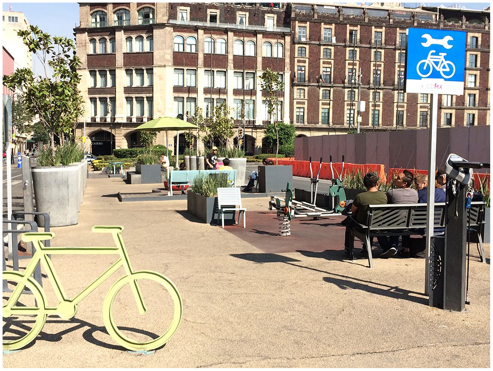
A new “pocket” park in the historic center, Mexico City.
On a broader scale, the redevelopment of downtown Mexico City is supported by the embrace of “flexible” land use regulation, a trend that accelerated under Ebrard (Parnreiter, 2015) and continued under Mancera (2012–2018) (Delgadillo, 2018). Ebrard’s administration implemented a series of new planning measures to facilitate real estate development projects, including tax incentives for developers and a more flexible and streamlined development approval process (Parnreiter, 2011: 14). In the same year that Ebrard signed the Mexico City Charter for the Right to the City (2010), the city government also promoted and passed a new Urban Development Law that created áreas de gestión estratégica (strategic management areas) to facilitate site-specific, property-led interventions. 24 These measures have facilitated fast-track approvals in Mexico City’s “global city zones” such as the Paseo de la Reforma corridor (Parnreiter, 2015: 21).
Between 2005 and 2010, approximately 14,000 housing units and 5,500 inhabitants were added to the historic center, reversing years of population decline (Delgadillo, 2016a; 2016b). Since new housing units may be the result of construction on vacant lots or the renovation of unoccupied buildings, the redensification of the historic center and downtown Mexico City does not always involve direct displacement, but it does involve a kind of exclusionary displacement through which redevelopment has “increased land and housing prices and . . . made it more difficult for low-income populations to remain in revalued central areas” (Delgadillo, 2016a: 1154). There is also growing evidence of displacement of lower-income renters from central neighborhoods such as Juárez as colonial-era houses used for multifamily rental housing are converted to “hipster” apartments, offices, and businesses (Delgadillo, 2017; 2018; González Alvarado, 2015; Walker, 2013). At the same time, higher land prices limit the ability of the Mexico City government to create new affordable housing in central areas with access to formal employment, urban services, and public transportation. For those displaced from their housing, this likely means a move to find cheaper land and/or housing on the periphery of Mexico City or on the metropolitan periphery in the adjacent State of Mexico (Delgadillo, 2018). For these households, relocation includes the double burden of not only losing their more centrally located housing but also displacement to a more distant periphery with fewer urban amenities and services, longer commutes, and higher transportation costs (Pradilla Cobos, 2015; Suárez, Murata, and Delgado, 2016). 25 If relocation entails a move to the metropolitan periphery, it can also involve the loss of eligibility for social programs in Mexico City that require proof of residency. In addition, direct displacement has affected informal vendors who have been evicted and/or relocated from more lucrative selling spaces in downtown streets, parks, zones, and plazas targeted for redevelopment. These multiple displacements highlight the contradictions between social and spatial planning in the city and inadequate attention to its stated commitment to the “social function of the city, of land, and of property.” While downtown Mexico City remains a diverse area, these processes of redevelopment and displacement continue to reconfigure its affordability and accessibility. Together, these impacts underline the relational nature of a more exclusionary downtown with the (re)production of social exclusion and the “entanglements of informality, peripheries and precarization” (Gilbert and de Jong, 2015).
The Periphery: Slow-Track Regularization
Mexico City’s conservation zone contains over 87,000 hectares and represents a significant site for the recharge of the underground aquifer that supplies over 50 percent of the city’s drinking water (PAOT, 2010). The Secretariat of the Environment (SEDEMA) has the primary responsibility for managing land use regulation in the conservation zone. In recent years, SEDEMA has introduced new planning policies for managing conservation areas. 26 Many of these efforts are directed at protecting the conservation zone (and the recharging of the aquifer) and at managing settlement expansion pressures, especially in those designated by the state as “informal” or “irregular.” According to official reports (PAOT, 2010), there are approximately 835 irregular settlements in the city’s conservation zone. There are also 36 rural towns, and many of them serve as structuring nodes in settlement expansion processes, especially for more recent settlement areas (Connolly and Cruz, 2004). 27 To slow this process, the Mexico City government has introduced policies in the zone to provide incentives to agrarian communities to maintain their lands in agricultural production or as forested areas through payments for “environmental services” (Pérez, Perevochtchikova, and Ávila, 2011). The local government has also implemented a relatively new approach to managing the expansion of informal settlement in the conservation zone on the city’s southern periphery. The borough of Xochimilco, with the largest number of catalogued informal settlements in the conservation zone, was one of the first to begin implementation of this new approach (see GDF, 2005). It has since been replicated in other boroughs in the conservation zone (see Aguilar, 2008; Aguilar and Santos, 2011). This approach is “new” in that it deploys spatial technologies (e.g., geo-referenced aerial photographs, digital maps) to map, count, and monitor informal settlements in the conservation zone (Wigle, 2010; 2014). Far more than just a technical exercise, these exercises of spatial calculation enter into state-community negotiations over the regularization of settlements. These calculations are also used to differentiate among settlements, placing them in distinct categories that affect regularization trajectories. With this new approach, communities may also receive a “discursive upgrade” by being shifted from one category to the next—without the state’s actually investing in improved housing or living conditions (Connolly and Wigle, 2017). For example, an informal settlement in Xochimilco “subject to control” may be upgraded to one “subject to special regulation” even though no material differences on the ground may be observed (Figure 2). These practices also suggest how so-called informal settlement is closely integrated with the planning system rather than outside of it.

A settlement “subject to special regulation”: Discursive upgrading in Xochimilco, Mexico City.
The regularization trajectories of settlements are neither linear nor straightforward but usually involve an opaque and convoluted process of regularization—an array of planning practices (e.g., site visits, community surveying, mapping, counting) conducted and often repeated over time in peripheral settlement areas (Connolly and Wigle, 2017). In this way, the suite of state practices that make up the protracted process of regularization is integral to identifying the territories of informality in which the housing of lower-income households is generally found (Connolly and Wigle, 2017; Wigle, 2014). It is also integral to justifying certain modes of spatial governance and regulation that may serve to reproduce social class distinctions and marginalized conditions if no material upgrades are actually implemented by the state. In practice, the regularization process can be both long and unpredictable, conveniently extending over at least several local election periods in which regularization promises are often part of the clientelistic practices of Mexican politics (Azuela and Meneses-Reyes, 2014; Varley, 1996).
The starting point for the regularization of settlements in the conservation zone pivots around a change in land use to residential use. 28 This process involves mapping, surveying, and community assessment studies to compile a detailed report on each settlement. These reports are supposed to be evaluated by a tripartite committee composed of SEDUVI, SEDEMA, and the borough’s elected head, but these committees are not always active. If a settlement receives a favorable report from the committee, the process may gradually move forward, although concrete decisions and outcomes can be difficult to identify. According to the approach outlined in the Xochimilco Urban Development Plan (GDF, 2005), residents in informal or irregular settlements are to pay a fine for damaging environmental services in the conservation zone before the sought-after land use change can be issued. 29 The contrasts in spatial regulation practices between downtown development and peripheral settlement emerge rather clearly here in terms of their related land use and planning approval processes. As downtown development processes are streamlined and some landmark projects are granted property tax relief (Parnreiter, 2011; 2015), those seeking accessible housing on the periphery are subjected to prolonged regularization negotiations that if “successful” require them to pay for damaging environmental services in the conservation zone. Although fast-track redevelopment and slow-track regularization are characterized by contrasting processes and practices, they are also co-implicated in the (re)production of exclusion and marginalization.
Similar to land use regulation in other parts of the city, regularization allows communities to be eligible for access to urban services on a formal basis, but there are other implications as well. Once a settlement is deemed “regularized” or “regularizing,” it becomes eligible to benefit from some social programs, including Mexico City’s much-lauded housing and community upgrading projects in marginalized areas. In addition to a residency requirement, households eligible for the PMV are defined as those earning between one and eight times the minimal monthly wage and those living on housing lots located on urban land or with a residential zoning designation on conservation land or on “regularized” or “regularizing” properties with evidence of ownership or possession (CDMX, 2017b: 510–511). The PMByC does not support projects located in the “conservation zone and/or informal settlements, unless they are in the final stages of regularization” (CDMX, 2017c: 204). Effectively, these criteria exclude marginalized areas with some of the higher levels of precarity in the city and mean that land use regulation may now serve as a gateway or barrier to some social programs in Mexico City (Connolly and Wigle, 2017). For many of the most marginal and fastest-growing areas of the city—including incipient and often precarious peripheral settlements—land use regulation represents a barrier to access to these housing and community upgrading programs. This situation highlights additional aspects of the tensions between social policy and spatial planning in Mexico City, calling attention to the need for more integrated approaches that not only preserve conservation land but also genuinely support access to affordable housing and the “right to the city.”
Conclusions
Many conflicts in Latin America pivot around land (Angotti, 2013b). This article focuses on the contradictory nature of how the local state regulates land in different socioeconomic territories of Mexico City. The analysis reveals the importance of examining social policy and spatial planning in tandem to better understand the city’s urban trajectories. Attending to the land-use–social-policy nexus uncovers some of the limits of sectoral and localized social programs in the context of broader market-oriented urban development trends. While the Mexico City government is to be commended for its extension of social programs for vulnerable groups and to marginalized areas, its own spatial planning policies may undermine the objectives of these programs and contradict its stated commitment to the “social function of the city, of land, and of property” and a compact and equitable city. As in other cities, the pursuit of a more “compact” city has produced a more exclusionary downtown, with advantaged access to urban amenities, renovated public spaces and public transportation for those who can afford to reside there, including short-term visitors such as tourists. While developers, investors, and higher-income residents benefit from public investments in downtown Mexico City, informal vendors and lower-income residents are displaced from these reconfigured spaces. For most lower-income households, displacement likely means relocating to cheaper land and/or housing on the city’s periphery, with disadvantaged access to urban services, amenities, public transportation, formal jobs, and the generally more central and lucrative selling spaces for those working in the informal sector (Eckstein, 1990; Strassman, 1987; Suárez, Murata, and Delgado, 2016). For those relocating to the even more distant metropolitan periphery, it can also mean displacement from a “zone of social entitlements” as nonresidents lose their residency-based eligibility for social programs in Mexico City.
The question of “what land use regulation where” can reveal a great deal about the operation of power in any city. This paper has argued that it is important to see what is conventionally referred to as the “regularization” of incrementally constructed settlements as a form of spatial regulation, just as downtown rezoning and densification are considered spatial regulation. This comparative view allows for the state’s role to be more fully scrutinized across the land-use–social-policy nexus in spaces of regulation that are conventionally bifurcated along the crude binaries of “center/periphery” and “formal/informal” or “planned/unplanned.” The dynamic of fast-track regulation in downtown areas and slow-track regularization in peripheral areas warrants ongoing investigation of its social impacts. In this context, it is important to see the trajectories of “dispersed periphery” and “compact city” (Pradilla Cobos, 2015) in relational terms, working in tandem to (re)produce exclusion and marginalization.
In 2018, Mexico City elected a new mayor, Claudia Sheinbaum Pardo (2018–2024) as well as a commanding number of other local representatives from MORENA, a new political party spearheaded by former mayor and now President López Obrador (2018–2024). Sheinbaum’s administration has adopted the slogan “City of Innovation and Rights,” referencing the considerable task of aligning the city’s programs with its new political constitution (CDMX, 2017a) which includes a specific section on the right to the city (Article 12). As part of these political reforms, the city will establish the Instituto de Planeación Democrática y Prospectiva (Institute of Democratic and Forward Planning) to oversee urban development and territorial planning in Mexico City. How these and other changes intersect with the current polarizing trajectories of “compact city” and “dispersed periphery” will play an important role in shaping Mexico City for years to come.
Footnotes
Notes
Jill Wigle is an associate professor in the Department of Geography and Environmental Studies at Carleton University, Ottawa. Recent publications include (with coauthor Priscilla Connolly) “(Re)constructing informality and ‘doing regularization’ in the conservation zone of Mexico City,” in Planning Theory and Practice (2017), and “De áreas verdes a zonas grises: gobernanza del espacio y asentamientos irregulares en Xochimilco, Ciudad de México,” in Antonio Azuela (ed.), La ciudad y sus reglas: Sobre la huella del derecho en el orden urbano (2016). She thanks four LAP reviewers for their insightful comments and Liette Gilbert, Priscilla Connolly, and Lorena Zárate for their helpful input on an earlier draft of this article. Funding for this research was provided by the Social Science and Humanities Research Council of Canada Standard Research Grant/410-2011-2427.