



Abstract
This study explores the spatial, social, and administrative conditions that shape Hong Kong’s grade-separated pedestrian networks. The integrated elevated pedestrian network was initially developed to facilitate internal circulation within the commercial centers when the city was undergoing rapid growth in the 1960s and 1970s. The vision was incrementally incorporated into statutory and administrative instruments as the city embraced a consumer-oriented economy. This study tracks the evolving concept of grade-separated pedestrian networks in Hong Kong, revisiting the critical actions and written notes in Hong Kong’s urban history from 1965 to 1997. The private sector was essential in building the multilevel pedestrian space and in making it a commercially viable urban model. An alternative perspective is proposed from which to consider Hong Kong’s public–private conflicts.
Keywords
Introduction
Hong Kong’s urban environment features extreme density, proximity, connectivity, and accessibility. The city is reputed to have one of the most efficient public transit systems in the world, and as a result claims an unimpeded pedestrian environment. The grade-separated pedestrian network emerged in the 1970s to accord pedestrian priority within Central’s commercial zone to promote a consumer-oriented economy. A “framework of pedestrian planning” was written into the Hong Kong Planning Standards and Guidelines, 1 which call for the provision of a three-dimensional pedestrian network comprising grade-separated links by elevated walkways, subways, and escalators. However, the regulatory system only partially accounts for the advent and mutation of Hong Kong’s three-dimensional pedestrian network, because planners and architects provided the vision before urban design control became a day-to-day practice in Hong Kong. 2 In a city-state built on the common law system, government intervention in integrated urban design control has limited statutory and administrative instruments for implementation. 3 In new town programs and other large-scale urban development, control drawings are produced together with special lease conditions to specify the particulars of development for each package. These drawings are then applied to the use of outline development, zoning, and layout plans produced by the government. Although urban design requirements are incorporated into spatial production through various indirect means, early inputs from planning professionals and design consultants are of great significance in shaping Hong Kong’s urban identity.
Hong Kong’s pedestrian networks are the products of a series of well-coordinated social actions. The pedestrian system has developed in tandem with ever-expanding large infrastructural developments through various property holdings, programs, and environmental objects. 4 Semigovernmental transit corporations and large real-estate developers have typically been the major stakeholders determining the connection and coordination of this networked environment. The Mass Transit Railway Corporation is a large player in creating mixed-use, pedestrian-friendly development within walking distance of transit stations. 5 Transit stations, open spaces, shopping malls, parking structures, and streets are all independently operated urban systems that must connect to and comply with each other at different levels through tunnels, ramps, escalators, conveyance belts, and lifts. The integration of environmental objects usually involves diverse stakeholders and takes different forms of property holdings, such as co-ownerships, project management, cash holdings, consulting, advertising, building regulations, and leases with conditions. The process of consensus seeking among these stakeholders should be based on a spatial design framework, and this spatial approach and its evolution in the literature on socially engineered environments require further investigation.
The remainder of this article is divided into four sections. In the first section, the authors review the literature on multilevel pedestrian zones in Hong Kong, including journal archives, colonial plans, and other public records. In the second section, the authors investigate the elevated pedestrian network as an urban design element, consulting journal archives from the 1960s and 1970s and project files to revisit formative moments in the discursive history of elevated pedestrian zones. In the third section, the authors discuss two case studies that cover a variety of planning perspectives. The two studied sites represent the materialization of the urban vision of pedestrian mobility in two types of urban cores. In the closing section, the authors engage in an open-ended reflection on pedestrian spaces in the context of privately owned public space (POPS) and offer an alternative perspective from which to view the mechanism of spatial production in Hong Kong’s tumultuous commercial zones.
Discursive History of the Multilevel Pedestrian Network: From Global to Local
A grade-separated pedestrian network is a pedestrian-only precinct independent from vehicular traffic. 6 It weaves through diverse outdoor and indoor pedestrian spaces in a continuous movement experience that creates a collective urban identity. From a commercial perspective, it seeks to create multilevel points of access, producing benefits for the city and private developers. The creation of grade-separated pedestrian networks in Hong Kong is an integral part of the city’s systemic endeavor to pedestrianize the urban cores and broaden its citizens’ social lives. The validity of this system is based on an assumption that the multilevel points of access increase the rental value of the mezzanine floor and enlarge the area dedicated to prime shopping space. 7 The system encompasses footbridges, lifts and escalators, roof terraces, atriums, and a broad range of indoor and outdoor spaces open to the public. The pedestrian movement structure develops “a group image from shared experiences” providing “a sense of underlying order to which individual freedom and variety are related.” 8
The concept of a comprehensive three-dimensional pedestrian network emerged in the early 1900s as a way to relieve congestion in high-density urban cores. The multilevel pedestrian concourses in New York’s Grand Central Terminal and Rockefeller Center were two early instances. In the 1950s and 1960s, different towns and cities began to experiment with the introduction of hierarchical traffic networks, multistorey car parks, and traffic-free precincts. In 1963, Professor Colin Buchanan’s report on traffic in towns consolidated these ideas into a general theory. 9 Alison Smithson’s proposition of “mat-building”—an integrated vision of separate experimental forms of traffic organization—described a dense, interconnected urban fabric, and this prefiguration of a new topography defined a thick urban field. Along with new traffic models advanced by the Buchanan Report, these innovative ideas were introduced to Hong Kong in the 1960s by technocrats in the planning department through coordination by the Hong Kong Branch of the Town Planning Institute.
The increasing conflicts between maintaining a pedestrian-friendly city and massive urban transformation became a major concern when Hong Kong was rapidly modernizing its built environment in the 1960s and 1970s. In a 1968 Rediffusion Television (RTV, now Asian Television) panel discussion titled “Architecture in Hong Kong” between four leading Hong Kong architects (Christopher Haffner, Alan Fitch, Edwin Wong, and James Kinoshita, interviewed by John Fawcett), elevated pedestrian linkage was suggested by Haffner as a way to make full use of the existing spatial potential. 10 Haffner suggested that higher-level pedestrian circulation be planned for Central to connect the major business area with the Star Ferry concourse so that “pedestrians could walk from shopping arcades to shopping arcades without having to nip through busy streets.” He also proposed a similar circulation system in the Naval Dockyard (now Admiralty). Yet other panelists, Edwin Wong in particular, were more concerned about the “human scale” and public open spaces within urban areas as Hong Kong was on the cusp of a new construction boom. Wong, opposing Haffner’s pro-urban vision, insisted that the Dockyard should be left as open spaces. Thus, the debate centered on coming to a new spatial solution that retained a human scale in a dense development area. In retrospect, some agreement did result from this public talk:
A multilevel circulation system should be built in Central.
Crowding not only poses problems, but also indicates opportunities to planners.
Urban proposals “measured in terms of dollars” should be put forward with respect to the public good.
More “self-contained” communities developed in a “cellular” way should be proposed to satisfy the housing demand and to reduce long-distance travel.
Ideas such as “uninterrupted pedestrian passage throughout the city” or “using the land twice” became broadly accepted in the architectural literature of Hong Kong in the 1970s. 11 Progressive urban propositions for increasing mobility in the metropolitan areas were introduced to Hong Kong’s public population through trade magazines such as Far East Architect and Builder (later Far East Builder and Asian Building and Construction) and Building Journal (Hong Kong). New developments in British towns such as the Barbican and Cumbernauld projected the future urban imagery of Hong Kong. As Christopher Haffner envisaged, a mile-long elevated pedestrian system in Central was planned in 1973 and built in the late 1970s. Meanwhile, the Navel Dockyard became a densely built commercial district with comprehensively planned pedestrian links. The first private pedestrian bridge in Hong Kong was built by Hong Kong Land to connect the Princes Building and the Mandarin Hotel. The first public–private coordinated pedestrian bridge—connecting Blake Pier and Union House as an integral component of the Connaught Center (now Jardine House)—was built in the early 1970s. This bridge was quickly extended into a network at a cost of HK$10 million and was intended to absorb half of the pedestrian traffic flow, specifically people emerging from the Star Ferry Pier. 12
In the 1960s and 1970s, Singapore, Malaysia, and Hong Kong as a unified Southeast Asian region under entrenched British influence (as previous or then current Crown Colonies) were generally considered by the planners and architects to experience common demographic pressures, and were thus given a unitary solution. When Murray MacLehose became Governor of Hong Kong in 1971, bureaucrats with technical backgrounds eventually gained discretionary power over the city’s public affairs, as the state was the largest employer of professionals and professional services. Planners and architects adopted Western city models and realized them in housing, infrastructure, and social welfare as a whole. Professional unions (such as the Hong Kong Institute of Planners, Architects and Surveyors) emerged and wielded more political power, with the introduction of specific urban forms and esthetics. Christopher Haffner became executive director of Spence Robinson and served as president of the Hong Kong Institute of Architects (1989–1990). Some consider the Shun Tak Center (Macau Ferry), designed under Mr. Haffner’s supervision and his most renowned project, to have realized the design guidelines and ideas he raised in 1968. The new town of Shatin was also planned against this background. The clustering of a well-planned mix of urban functions on a shared and networked pedestrian platform was actually a more intensified version of Central, as shopping arcades began to be annexed by both private and public skywalks.
Multilevel Pedestrian Network as Design Code
Given that almost all of Hong Kong’s land is “nationalized” (Crown and later Special Administrative Region [SAR]), all private developments that take place on public land are subject to the terms of Crown leases. The Crown leases stipulate that in the case of comprehensive large-scale private development, a master layout plan must be prepared and submitted for approval to the satisfaction of the Director of Lands. 13 In many cases, master layout plans are employed both to protect public access to the privately social spaces and to encourage a self-contained project. The planning consultants’ role is critical in this process because they lay out the movement system, which frames the future development and circulation pattern, and ensuing programs catch up and fill up quickly. Bonus floor areas are granted by the government as incentives for private developers to build spaces accessible to the public. An interior atrium can be privately owned (through Crown lease) but open to the public for round-the-clock pedestrian passage under the condition of land lease. Although such mechanisms are now violated more often by private owners, they have also resulted in models of welfare spaces provided by the private sector.
In the Hong Kong Preliminary Report (1948), Sir Patrick Abercrombie observed that the shops squeezed in at the ground floor of Central’s offices had started invading the second floor spaces, and there was no large shopping center in Central. Abercrombie called for comprehensive redevelopment for a traffic-free town center. 14 The idea of a “traffic-free town center” was influential in Hong Kong’s initial new town planning. In an early review of the plan for Shatin, the Hong Kong Society of Architects suggested the adoption of the town center models used in Vallingby, Sweden, and Cumbernauld, Scotland, as guidance in laying out Shatin’s self-contained town center. This resulted in the “megastructure” form of Vallingby and Cumbernauld influencing Hong Kong’s town planning with the intention of contributing to the public good (Figure 1). 15

Diagram (left) of the “New Urban Form” introduced in the Colony Outline Plan, 1969.
The Buchanan Report (or under the title of “Traffic in Towns,” 1963)became a widely acknowledged planning code in Commonwealth nations. 16 Buchanan’s idea of pedestrianization in civic centers has been a part of common sense in urban planning practice today (Figure 2). In an essay titled “Planning in Hong Kong” published in Far East Architect and Builder magazine, R.C. Clarke, the assistant superintendent of the Crown Lands and Survey Office, outlined Hong Kong’s planning problems. He observed that “space on pavement is becoming wholly inadequate for the pedestrians.” Despite the growing number of domestic buildings, “the occupants eventually return to ground to horizontal movements in two dimensions” and the city was unable to provide adequate public communication at ground level. Thus, he expressed his support for a “two-level circulation (in city centers) with pedestrians able to move freely over large areas segregated from wheeled traffic.” 17 The implementation of grade separation has been developed as a solution to reconcile the conflict between the growing vehicular traffic and pedestrians.
Urban transport integration.
A “future urban form” concept was introduced in the Colony Outline Plan issued by the Crown Lands and Survey Office in 1969 (Figure 3), 18 which anticipated an urban form comprising self-contained “cities within a city,” and called for a “new approach to land use planning and development so as to allow for a greater degree of vertical integration of urban functions, which already exists in a haphazard form in many districts.” It also called for “modern building technology and well-conceived architectural design” to “provide an acceptable solution particularly in new government and government-aided housing estates, which can be planned and developed as a whole.” It profiled a multideck city with community uses, public podiums, flats, local shops, workshops, retail uses, and parking—all integrated into one megastructure riding on a mass transit line. 19 Visually, it was an updated version of Hilberseimer’s Hochhausstadt scheme. 20 The 1969 Colony Outline Plan acknowledged that spontaneous vertical integration had appeared “in a haphazard form” in Hong Kong and explicitly suggested a public–private colaboration for future urban development. The Colony Outline Plan preceded the later Hong Kong Planning Standards and Guidelines.

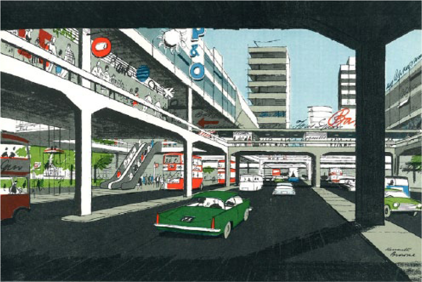
Urban design guideline examples of movement through buildings.
During the three decades that followed the inception of the Hong Kong Colony Outline Plan in 1965, the three-dimensional pedestrian network took an increasingly clear form. Because the future of Hong Kong was determined by the Joint Declaration, which was released in 1984, the city increasingly played a new role in the rapid urbanization of the entire Pearl River Delta, rather than as a free port. Hong Kong moved to a new track oriented toward consumption and tourism. The 1990 Metroplan, as the last colonial plan for Hong Kong, was the product of a citywide brainstorming session. It presented fresh thoughts from interested individuals and community groups and provided a framework through which both public and private sector agencies could formulate detailed plans and development programs with a common aim. 21 Compared with the 1969 plan, Metroplan recommended a focal shift to certain broad design principles and guidelines to enhance the three-dimensional form and character of the city. Metroplan suggested that pedestrian networks should be provided in major commercial areas populated by shops and offices and characterized by high-density pedestrian movement. These pedestrian networks would be continuous, high-capacity, grade-separated, all-weather, noise-protected routes for pedestrian circulation.
In the booklets printed as public records for the Metroplan, the urban design concepts of “enclosed pedestrian streets” and “(pedestrian) movement through buildings” were illustrated by a few diagrams, which knitted footbridges, podiums, subways, car parks, atriums, and lobbies into a unified environment. The Metroplan anticipated a more extensive, multilevel pedestrian system linked to major transport interchanges and commercial programs. The public pedestrian routes would supposedly penetrate different functions at different levels and assemble a stratified urban environment (Figure 4). It should be noted that the Metroplan promoted “an environment protected from noise and air pollution” and “public exhibitions and events,” signaling Hong Kong’s decision to embrace consumerism. 22
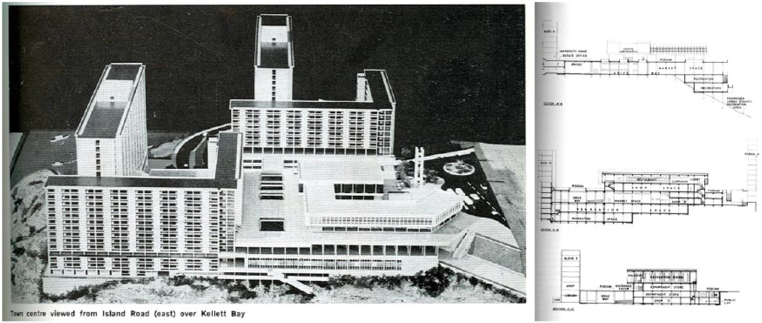
Pedestrian podium of the town center of Wah Fu Village.
The late 1980s bore witness to a group of emerging local architects and urban designers, of whom Rocco Yim is representative, who conceived a new vertically integrated urban vision. Yim’s concepts of “urban connector” and “fluidity” dominate his architectural projects in Hong Kong’s urban centers.
23
In a 1985 essay entitled “The Aesthetics of Fluidity,” Yim expressed his concern with density and affirmed his role both as an architect and an urban designer. His consciousness of the public realm in motion was first evident in his design for the Citibank Plaza project. In the introductory essay of his monograph, Yim defined urban connectors as follows: The city’s urban connectors, some by expedience, others by intent, have now grown from simple disjointed linear elements into a multi-directional and multi-dimensional network. . . . The architecture is an inside-out process, where a contiguous series of connector spaces in various guises; bridge, atrium, open deck, subway are composed as a continuous route that knits together the social, traffic, circulation and open space systems in the neighborhood.
24
In an article entitled “Ambiguous Space, Ambiguous Rights,” Cuthbert and McKinnell saw the prevalence of such pedestrianized spaces as a phenomenon of loss of public space. 25 The article sorted this phenomenon into three forms: the public realm, which becomes incorporated into the footprint of large new building complexes usually owned by multinational corporations; pedestrian movement, which is designed to reinforce monopoly land holdings by channeling pedestrians through corporate space as a function of commodity aesthetics; and the encouragement of large shopping centers to provide internal atriums, courtyards, and streets, replacing civic space with the commodity space of the market. Cuthbert and Mckinnell argued that “the combination of Imperialist hegemony with the traditional values of Chinese Culture have created an economic system where the pursuit of wealth has religious properties.” Many parts of the pedestrian networks in Central and Wan Chai were built on newly reclaimed plots before they were developed. They anticipated and pioneered the future urban formation of Hong Kong, guiding the flow of capital through spatial intervention. It should be noted that Hong Kong’s government is not considered authoritative, as it serves as an intermediary between large land owners. Laypeople’s needs are always satisfied in an indiscriminate, or less than conscious, fashion. The integrated pedestrian environment appeared in a historical context in which demographic and financial concerns prevailed. A great portion of the overhead pedestrian linkages and interior concourses in Hong Kong were built by neighboring private properties to promote commercial viability through the use of POPS. 26 This system created extra value for businesses that were traditionally located at street level, and reduced the traveling time of Hong Kong’s commuters. However, the system did not address the deep conflicts between the private and the public.
The pedestrian network became a compulsory POPS and Governor MacLehose was applauded for his benign rule and the promotion of neoliberalism, which was founded on a stable increase in public welfare, of which public space is an integral part. The Hong Kong government’s involvement in land sales, urban planning, and infrastructure revealed its acceptance of “Buchananism,” which was designed to maximize the health, safety, convenience, and public good of the community. 27 The public good, in the form of better connectivity, accessibility, and mobility, was created as dividends, or subsidization of the “social wage.” 28 In this case, the dividends were paid by the private land owners who financially benefited from the innovative space organization. This mechanism was based on the assumption that all walkers are potential shoppers or clients of neighboring businesses. Recently, this assumption has been challenged, as these “ambiguous spaces” or pseudo-public spaces are increasingly used to host noncommercial activities and political demonstrations. The unified identity of hard-working, obedient middle-class Hong Kong people has been replaced by more heterogeneous social and ethnic groups with a variety of identities and conflicting ideologies (for instance, between foreign domestic helpers camping in public spaces and other pedestrians or between Mainland tourists and local Hong Kong people).
Case Studies
The following case studies are used to investigate two distinct scenarios in which networked pedestrian circulation systems are situated: the Shatin Town Centre and the IFC-Exchange Square complex in Central. These two cases demonstrate distinct examples of spatial production in a new town and downtown and both are testing grounds that illustrate the influence of incorporated urban design requirements as underlying principles in early planning processes. These cases are also instances of different degrees of urban design control. In the 1970s, the attention of planning sectors in Hong Kong was concentrated on the New Territories, and Shatin was the biggest Mark I new town. In the mid-1980s, interest shifted back to urban areas, especially the harbors and waterfront. These case studies are intended to be representative rather than exhaustive. The analysis concentrates on their associations with the two metro plans discussed previously (the 1969 Colony Outline Plan and the 1990 Metroplan). These cases focus on the shaping of the multilevel pedestrian networks and the urban concepts behind these conscious but limited urban interventions.
Case Study 1: Shatin Town Centre
Before the Shatin Town Centre, Wah Fu Village was the first new settlement illustrating the concept of uninterrupted pedestrian-only zones. The pedestrian podium of Wah Fu Village was designed to be directly accessible from the street level, linked through a footbridge to neighboring amenities and anchored by a three-story complex containing a department store, fifteen shops, and restaurants. The elevated pedestrian terraces became extensions of the interior shopping arcades with landscaping features. This spatial pattern set precedence for later large-scale pedestrian networks in major new towns and city centers. Mei Foo Sun Chuen’s networked podium deck was another manifestation of the zeitgeist in the 1970s. Hong Kong’s industrial boom gradually closed the gulf between rich and poor while the emerging middle-class population’s growing need for a more secure and decent environment demanded a networked, landscaped podium deck as a spatial statement of a self-contained community.
The planning for Shatin started as early as 1961. In a June 1961 review of the Shatin plan (LST 17) issued by the predecessor of the Hong Kong Institute of Architects, the HKSA, a town center riding over a railway line was suggested, modeled on Vallingby and Cumbernauld. As the 15th New Town designated in Britain, Cumbernauld’s design revolutionized the principles of the early Mark I new towns. 29 The town center of Cumbernauld was conceived as a self-contained megastructure with a cluster of overlaid multidecked structures riding on an arterial carriageway, which reflects the pursuit of both mobility and urbanity. As the British political climate grew more conservative, financial support for such a utopian experiment dwindled, but its architecture and planning rationale were reported globally and had an explicit influence on Hong Kong.
The Territory Development Department was formed in 1973, the same year the plan for Shatin was originally put to paper. The area in the vicinity of the East Rail Shatin Station was originally developed as a natural extension of the old street market, providing the new town with a concentration of shopping facilities and a major public transport interchange. The cultural complex, which is linked to the Shatin Station by commercial development, is the principal focus of the Shatin Town Centre, providing comprehensive facilities including a public library and a town hall. As the cultural complex is located within the low-rise civic spine, it is visually dominant from the surrounding pedestrian areas. Shatin’s Law Courts are located beside the cultural complex. The Shatin Park, situated between the cultural complex and the Shing Mun River, complements the development in the town center. It is the focus of the open space theme along the Shing Mun River. Shops, offices, cinemas and other commercial and recreational facilities are located within the town center. (Figure 5)
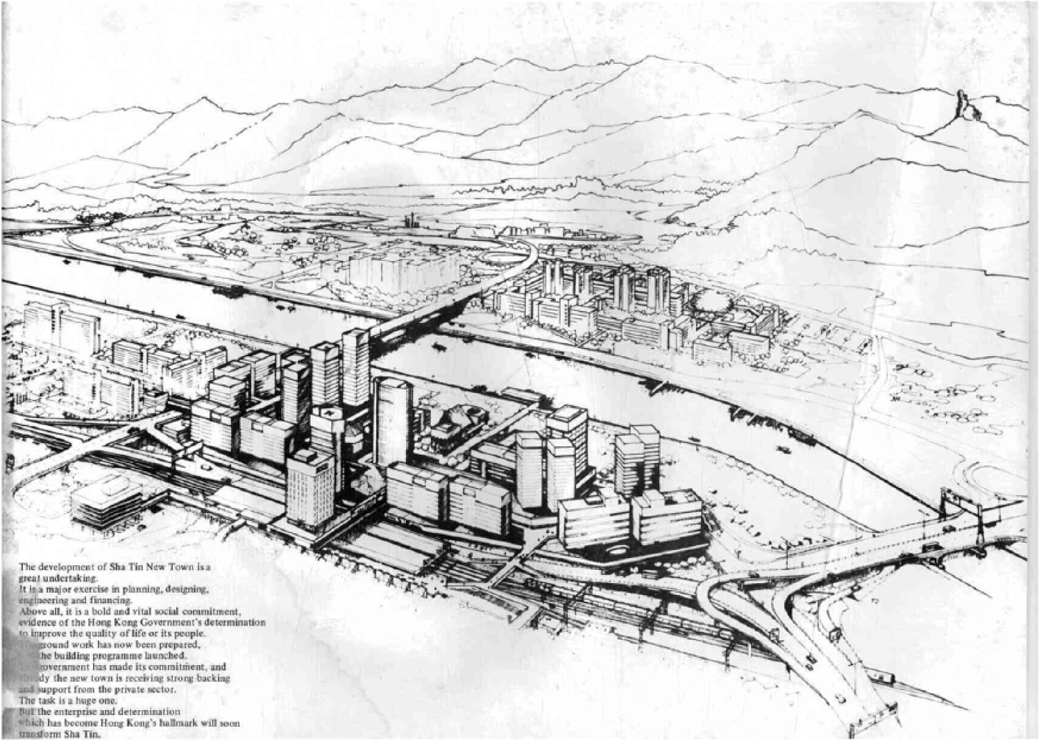
Shatin plan in 1976 drafted by the Hong Kong government’s own planners.
In the planning process for Cumbernauld, the Mark I schemes of British new towns were criticized for their “pseudo-village green” appearance, which was seen as detrimental to civic pride. The megastructures, in contrast, were argued to be able to assist “urban concentration” and provide a sustainable urban solution. 30 These discussions were noted by Hong Kong planners, and the concept of an “activity center” prevailed in the development of the new town civic centers. 31 The all-in-one urban form was intended to contribute to an introverted urban utopia in a sea of urban chaos. The integrated pedestrian network became a social instrument for resolving functional conflict and congestion in Hong Kong.
The first Outline Development Plans for Shatin were approved and published in 1962. A draft plan for Shatin published by Far East Architect and Builder in 1965 indicated that a multipurpose commercial residential development would be implemented to ensure the maximum use of amenities, and “segregation of pedestrian and vehicular traffic was recommended in the detailed planning stage.” In 1969, the first plan for the center was produced for circulation and featured a series of open spaces and recreational areas linked by an at-grade central pedestrian routeway. However, doubts were raised over its vulnerability to hawkers, which were a negative factor in planning at the time.
The development of new towns gained momentum in the 1970s. In 1973, the British planner William Holford proposed a plan with a continuous elevated podium deck concentrated on a central commercial core. Again, this plan was opposed by government as a comprehensive scheme because it was considered unpractical. Likewise, Holford was involved in the planning of Piccadilly Circus of London in the early 1960s, where pedestrian segregation was also planned, and suggested that public and private enterprise should combine in some sort of trust or consortium. This type of consortium was later adopted by the Hong Kong Mass Transit Railway Corporation (MTRC) to develop the Hong Kong Station complex. The elevated pedestrian deck and commercial podiums were maintained in the 1976 plan drafted by the government’s own planners.
Instead of a public–private consortium, special lease terms were imposed in this version of the plan. The lease terms stipulated parameters including the construction and linking of shopping podiums, predetermined levels and boundaries in accordance with plans and models (Bristow, 1989, p. 249). The lease terms resolved the private–public conflicts in Holford’s proposal. In 1982, consultant Yuncken Freeman’s detailed site design provided a larger single-use retail center as a circulation hub for the Shatin new town, and his recommendation of urban forms was exercised through the compulsory lease terms. It is also noteworthy that the provision of a single-ownership town center (without office or residential towers) might expedite land leases in the future, given the unclear prospects for Hong Kong in 1982 before the Sino-British Joint Declaration was signed. Those lease conditions ensured the permeability and accessibility of the space within the shopping center (Figures 5 and 6).
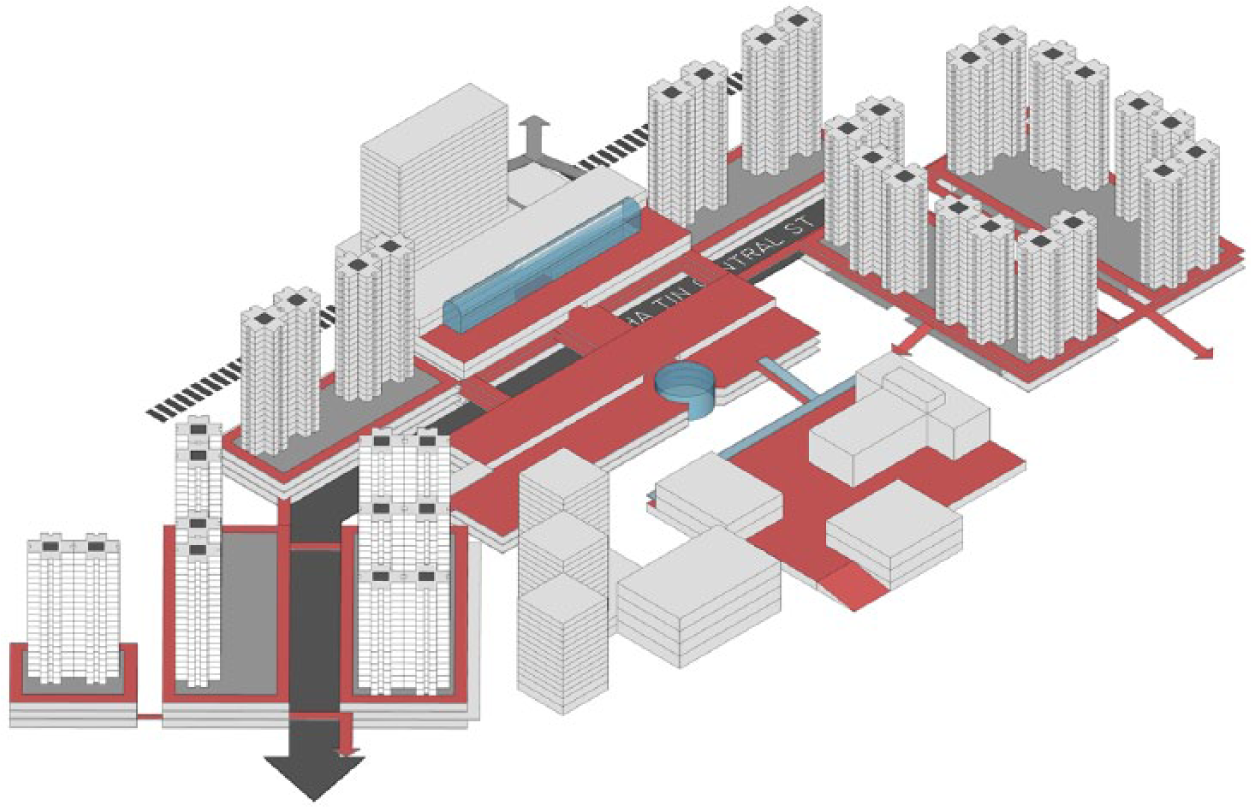
The pedestrian network of Shatin Town Centre (highlighted in red).
In the final plan for Shatin, the effects of the enormous building masses were reduced through the use of human-scale spaces. The relatively low rise character of the town center was planned to smooth pedestrian movement from the train station to adjacent estates, cultural amenities, and open spaces. These pedestrian-friendly gallerias, skywalks, and podium terraces between tall buildings reduced the psychological effect of these structures on the general townscape and offered visual and physical, human-scale enclaves to distract attention from the vertical towers. An equally safe and uninterrupted cyclist system was provided to link the Shatin Town Centre with peripheral estates, industrial areas, and open spaces (Figure 7). 32
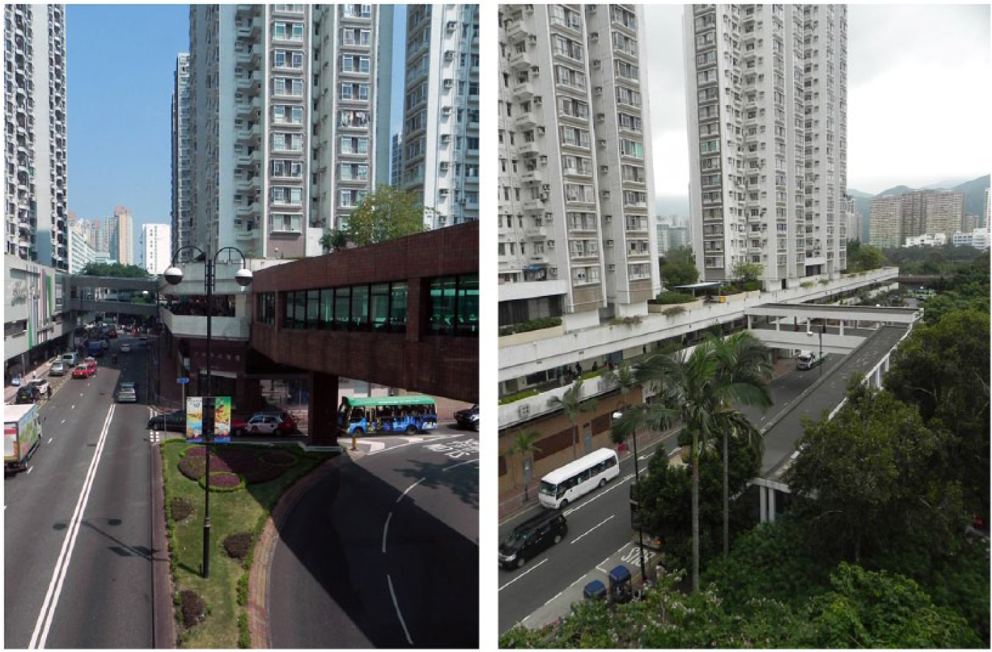
Multilevel pedestrian skywalks in Shatin Town Centre.
The single-ownership of the Shatin Town Centre ensured that the entire pedestrian complex would be fashioned as a whole. Yet this arrangement initiated the privatization and corporatization of Hong Kong’s public space in the commercial districts. In 1984, Shatin’s New Town Plaza opened. In 1990, Phase III of the New Town Plaza was built with the addition of three floors of shopping gallerias. The lease conditions for the New Town Plaza stipulated that a certain amount of shared and around-the-clock spaces should be reserved for the local community. The public good was protected not only by the lease but also by the configuration of the spaces, many of which were passageways or roof terraces not available for commercial use (Table 1).
Privately Owned Public Passages and Spaces within Shatin Town Centre.

Case Study 2: Central
In contrast to Shatin, the integration of Central’s retail space began in a more indiscriminate fashion. Footbridges, as the key components of the elevated pedestrian networks, were proposed and constructed as early as the late 1950s. The early footbridges were temporary scaffolding structures built of steel, wood, or bamboo (Figure 8). Central’s networked pedestrian system originated in the footbridges primarily built by Hong Kong Land to connect its own properties across a few city blocks. These original elevated bridges were sheltered and partially air-conditioned. The first perpetual private footbridge in Central, designed by Parmer and Turner Architects, was built in 1965 to connect the Mandarin Hotel to the Princes Building. It was the first to provide a sheltered connection between the two-story shopping arcades of the buildings. Central’s land owners soon recognized the commercial value generated by the significant pedestrian flow. As discussed in the earlier sections, the construction of elevated walkways was greatly informed by the collective visions of architects and planners in the 1960s. These separate walkways metamorphosed into a network of internal pedestrian arcades beginning in the early 1970s, and became integral components of future private developments.

1950s temporary footbridge and 1965 steel footbridge on Chater Road.
In 1974, Hong Kong Land announced a redevelopment scheme that included a 1,860 m2 pedestrian plaza, Landmark—the first modern atrium of its kind in Hong Kong. In 1976, the Mass Transit Railway Corporation (MTRC) signed an agreement with Cheung Kong Holdings to develop a twenty-six-story tower at the old General Post Office site. The tower was intended to house retail arcades leading to the concourse of Chater Station (now Central Station), a three-level station with the concourse on the top level. Such actions were prototypes of urban interventions of larger scope, such as the Hong Kong Station and more recently Kowloon Station. As early as the late 1970s, the MTRC entered the property development field. 33 By integrating a multitude of programs and circulations around metro stations, the MTRC became a powerful player in shaping uninterrupted pedestrian networks in Hong Kong.
The knowledge gained from building several generations of pedestrian networks culminated in the development of Hong Kong Station on reclaimed land in Victoria Harbor. Nearly eighty thousand commuter and express line passengers were expected to join the pedestrian flow through Central at every peak hour once Hong Kong Station was built. 34 The integrated grade-separated pedestrian network was implemented by the municipal authority and the MTRC as a mutually beneficial strategy for both the public interest and the retail environment. In the early stages of the airport line planning, the MTRC consultant developed a series of design guidelines for future airport line stations. Central to the guideline was that an interface should be built between the station and its attached property and the surrounding urban functions. Thus, Hong Kong Station eventually became a new hub for Central’s pedestrian circulation. Although most of the grade-separated walkways and retail galleries were rarely used for purposes other than passage, it arguably demonstrated a new public experience in a high-density urban culture (Figure 9).

1984 map showing Central’s footbridges.
When Exchange Square was built in the 1980s, the landscaped podium terrace and a superstructure (a four-story forum) between the two towers on the first floor were reserved as an integral part of future pedestrian network expansions. The column array under the podium was largely spaced (ranging from 16 to 22 m) to accommodate the bus terminus and the future underground tunnel between Hong Kong Station and Central Station. During the early stages of Exchange Square’s planning and construction, the government reserved two strips of underground space for the construction of that tunnel. This pedestrian subway was designed to cater to forty thousand people every hour and was equipped with a 300-m travelator system. It was completed and opened to the public for use in June 1998. The 1990 planning documents showed that the elevated walkway along the north edge of Exchange Square was built before Hong Kong Station Phase I was completed, indicating that the underlying pedestrian system usually preceded future land development. 35 However, these separately built first-story pedestrian zones are at different elevations and the subtle grade changes between the footbridges, indoor galleries, terraces and links has become Central’s most vibrant spatial quality. The pedestrian circulation revolving around Phases I and II of the International Finance Center (IFC) and Exchange Square complex has become a hub of elevated walkways, retail arcades, and public transits that encourage the public to smoothly navigate its different programs and uses. This walkway system is further connected to ferry piers on the newly reclaimed waterfront.
An alliance between Rocco Design and Arup was commissioned to lead on the development of Hong Kong Station (International Finance Center) when Central Waterfront Property Ltd. won the bid. Although the site for Hong Kong Station was relatively defined, under Hong Kong planning law the rules for stations differ from normal developments. As a transit-oriented development, the station, tunnels, and supporting facilities were allowed to extend outside the site. There were two major suggestions from the architects regarding a continuous pedestrian-friendly experience. The first was that the two super-high-rise towers be reduced to one tower at the northeast corner, which would prompt the Town Planning Board to waive the height control on the new buildings along the harbor front. The second was that the bridges between the Phase I and Phase II development sites include multilevel retail galleries. These approaches significantly removed interference in the pedestrian circulation and harbor views, creating a larger podium roof that could be used as a waterfront park accessible to the public. It should be noted that these POPS were reserved for public use according to the conditions of the land leases (Figures 10 and 11).

Section showing the elevated pedestrian deck of the IFC-Exchange Square complex.
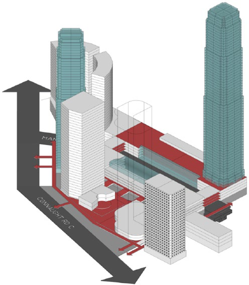
Pedestrian network of the IFC-Exchange Square complex (highlighted in red).
The pedestrian circulation through Hong Kong Station and Exchange Square significantly enhances Central’s existing pedestrian character. The station complex features two concourses for the arrival and departure of the Airport Express line, respectively, and contains six levels of public circulation and diverse facilities—from the elevated pedestrian terraces down to the lowest rail bed (plus two extra levels of retail and one public-accessible roof garden above the retail podium). A mezzanine above the Airport Express rail bed connects the arrival and departure platforms. The whole complex, annexed with Exchange Square at the first floor, caters to one commuter line, one express train to the airport and a bus hub while providing an automated conveyor system that connects to Central Station, which was built before Hong Kong’s return to China. The pedestrian system on the first floor stretches to encompass a larger business area that includes Sheung Wan, Mid-levels and Admiralty. In 1998, the Airport Railway Hong Kong Station Development (the International Finance Centre [Phase I]) was completed and the construction of Phase II began that year (Figures 12 and 13) (Table 2).
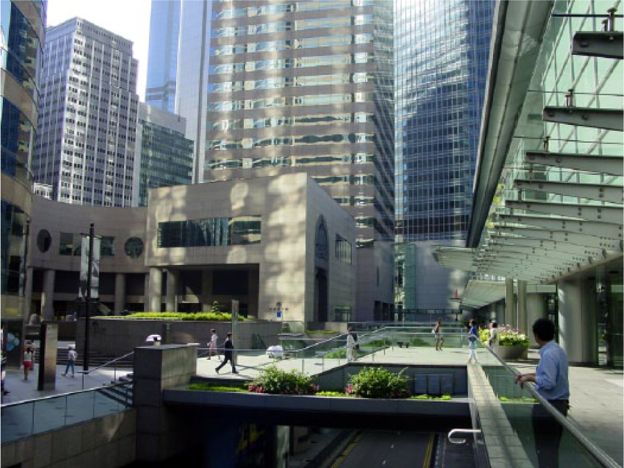
Pedestrian deck connecting Exchange Square and Hong Kong Station (IFC Mall).
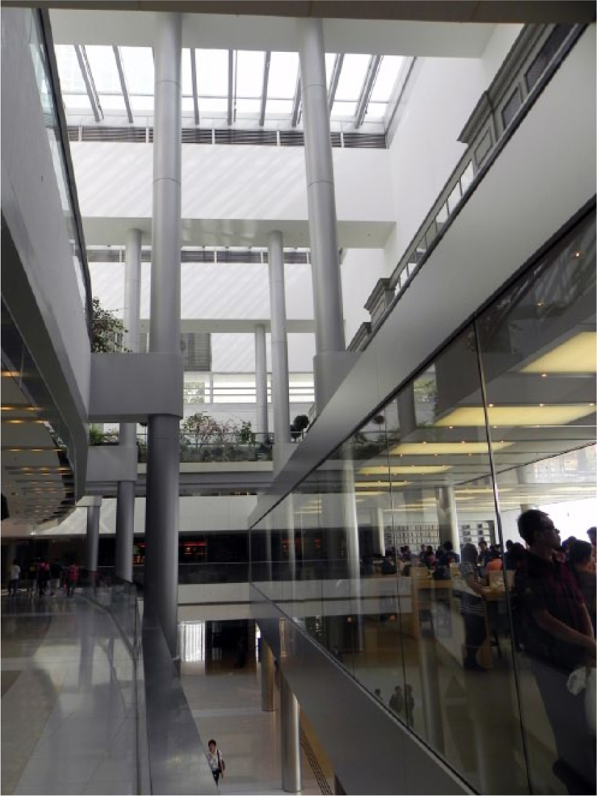
Multilevel retail arcades inside the bridge connecting IFC Mall Phases I and II.
Privately Owned Public Passages and Spaces within Hong Kong Station and Exchange Square.

Conclusion and Reflection
Shatin Town Centre and Hong Kong Station complex can be positioned in a historical trajectory in which the postwar megastructural utopia, mostly developed from a global urban design perspective, materialized into a local pro-business urban model. Both sites are of special civic design interest and the dedication of land for public circulation and other public amenities was proposed and regulated at very early stages in the land development. In addition to Shatin and Central, several other activity centers in Hong Kong indicate comparable urban experiences and spatial patterns, such as Grand Century Place and East Mong Kok, Queensway Plaza at Wan Chai, Tsing Yi Station and Tsim Sha Tsui East. It is noteworthy that master layout plans, despite the absence of statutory obligations, ensured that the public interest was satisfied in a comprehensively planned urban form. Yet these forms were planned in a monotonous way, indifferent to the colorful community cultures and rhythms of everyday urban life. In many cases, despite refined architectural detailing and coordination, the multilevel spaces are visually displeasing and discordant in relation to the urban context. The maturation of urban design machinery has not been able to satisfy the cultural and experiential demands of space users, who represent diverse identities and social roles.
In discussing the redevelopment plan for Piccadilly Circus in London, Buchanan acknowledged that the London County Council could not take in all the “non-revenue” elements (strolling space, promenade decks, traffic bridges, pedestrian vantage points) unless the Council owned the entire area, and that “the inventiveness of the private promoter could be used.” 36 The questions that Buchanan and his contemporaries had about comprehensive planning and private–public coordination have somehow been answered by Hong Kong’s unique land policy, urban practice, and civic culture. Presently, much attention is drawn to criticisms of the segregation of the elevated pedestrian network from street life in public literature. Journalist Violet Law of South China Morning Post expressed concern over the disappearance of pavements, crossings and other forms of social space that results when pedestrians are channeled through footbridges and subterranean tunnels. 37 This critical stance echoes Cuthbert’s narrative that public space has been interiorized and reproduced in commodity space. The gentrification of these pedestrian systems demonstrates Hong Kong’s transformation into a postindustrial city, as the 1990 Metroplan anticipated. However, Cuthbert’s criticism of the shrinking public sphere did not consider the “social wages” produced by Hong Kong’s multilevel pedestrian networks, which are the product of a spatial consensus reached by different social agencies in a certain period of history when commercial viability prevailed and of a spatial mechanism propeled by both the power of enterprise and the public will.
The 1961 new Zoning Resolution of New York set forth a policy to allow potential developers to build covered walkways through block arcades and plazas to create an open concourse in exchange for a bonus floor area equivalent to seven Empire State Buildings. 38 The practices of POPS contested the assumption that public spaces ought to be provided and managed by the public sector. Gordon Bunshaft’s Lever House on Park Avenue was the first of this kind to give its ground level over to the public. Compared with those in New York, Hong Kong’s POPS adjoin the architectural detailing of adjacent buildings for an integrated urban experience. Public space has not been shaped by a prescriptive design code but rather by a consensus reached by a variety of stakeholders. The private sector is essential in implementing many of the Hong Kong government’s development objectives, inevitably implying blurred boundaries between the public and the private. Urban design guidelines should thus be proposed to prevent public space from being used for commercial gain, although proper uses for commercial purposes should be preserved if they enhance the vibrancy of the space in site-specific circumstances. Undoubtedly, the protection of public space cannot be subject only to administrative apparatuses or regulations (lease conditions, zoning ordinances, or metro plans). It should encompass the broader perspective of a socially refined spatial mechanism of mixed services, amenities, and facilities. More attention should be paid to forming a public realm constituted by collective motions, activities, programs, and events.
Footnotes
Declaration of Conflicting Interests
The authors declared no potential conflicts of interest with respect to the research, authorship, and/or publication of this article.
Funding
The authors disclosed receipt of the following financial support for the research, authorship, and/or publication of this article: This article is part of a study supported by research funding of City University of Hong Kong (grant no. 7002844) and National Natural Science Foundation of China (grant no. 51278438).