



Abstract
Patterson Colony, an agricultural town built out at the height of the City Beautiful era, exhibits that movement’s distinctive monumental geometries writ small, imitative of Washington, D.C., and jarringly unlike its grid-bound neighbors in California’s Central Valley. The story of Patterson’s street plan sheds light on an unfamiliar site and scale of comprehensive planning, and shows how the beautifiers’ rhetorics could be recoded and harnessed to a speculative real-estate venture. In Patterson we see these tropes—“order” in particular—taking on complex valences that are at once aesthetic and technical, revising any hard-and-fast distinction between City Beautiful and City Practical imaginaries. This history, finally, allows us to rethink how replicable urban forms travel, and to specify the meanings, uses, and predicates of self-appointed “model” towns—a designation that has been attached, sometimes incautiously, to countless episodes in the evolution of the American city and suburb.
Keywords
Comprehending a “Model” Landscape
Patterson, California, is visibly unlike its neighbors on the San Joaquin Valley’s sparsely settled, perennially disrespected Westside. Platted in 1909, the place was always, in the mind of its zealous developer and namesake, the Fresno banker Thomas W. Patterson, meant to be “a town of distinction and beauty,” “a full-scale community.” 1 To his chagrin, Newman, Gustine, and other speculative settlements that had sprouted along the Southern Pacific’s Westside Branch following its arrival in 1887, had assumed all but interchangeable grid forms—insidious grids, he thought, that quickly filled with saloons and “shacks.” 2 His Patterson Colony, by contrast—no larger than these towns, and fundamentally no less provincial—would be conceived comprehensively and from scratch, its street plan explicitly modeled on the radial forms of the nation’s capital, and before it Haussmann’s Paris. 3 Patterson concocted a circular central plaza, ceremonially placed eucalyptus and sycamore trees, an enclosing ring road, a series of fountains and roundabouts at key intersections, a three-mile palm-lined axis leading east from town to the San Joaquin River, and a system of radial boulevards extending outward like the spokes of a wheel. Its irrigation secured, its showpiece calibrated for perpetual display, Patterson’s form was to channel the City Beautiful writ small: stripped down, yes, and transplanted to the agricultural hinterland, but justified in the same vaguely deterministic language of order, harmony, and moral uplift. 4
Histories of the City Beautiful spatial imaginary, and of comprehensive planning schemes before and since, sometimes lapse into exaggeration and platitude. Its high-handed sponsors invite all kinds of retrospective critique, but their excesses can too easily divert sustained attention from the formal particulars they ended up depositing on the ground. Tracing the derivation, execution, and continuing career of this one oddly grandiose landscape reveals a more complex drama of aspiration and persuasion. Patterson was indeed laid out to be gazed upon—by inhabitants and by visitors—apprehended in a glance and imbued with a stock aesthetic identity, a sort of peri-urban “place brand” avant la lettre. In another sense, though, orthogonal to its purported beauty, these trappings of order served as one booster’s technical instrument to reassure and rapidly sell irrigated property to distant—mostly Midwestern, mostly Scandinavian—would-be Californians. Its geometries worked to enframe the town, to make Patterson’s forms not only desirable but intelligible, transmissible, portable. Negotiating the balance between these imperatives, the aesthetic and the technical, allows us to revisit the meanings, uses, and predicates of “model” landscapes—a designation casually attached to countless environments, seemingly complete, that speculators, employers, card-carrying planners, and various sorts of reformers have worked out, with especial vigor since the Progressive era, at or just beyond the edge of the American metropolis—and to rethink how urban models travel, touch down, and morph. In an oblique way, the story of this aspirant “City” Beautiful belongs to an inclusive prehistory of the packaged residential suburb that would mature and close ranks in the decades to come. It allows us, too, to scrutinize the peculiar sorts of cultural and economic work that landscape form—abstract, geometric form as such—has been enrolled to carry out.
Giving Form to Life in a “Garden Town”
Until 1864, the land that became Patterson formed part of the Rancho del Puerto, an expanse demarcated by the San Joaquin River to the east, El Puerto Creek to the north, the Diablo Range to the west, and what is today Crow’s Landing on the south. John D. Patterson, Thomas’s uncle and a successful rancher near Buffalo, New York, had come to California in 1854, sailing around Cape Horn with the sheep he would raise in the Central Valley’s milder climes. Patterson the elder never settled full time in California: he would winter in the company of his sheep and otherwise administer his ranches from New York. But he worked assiduously to enlarge his holdings, which totaled twenty thousand acres by his death; established tiny Patterson’s Landing on the banks of the river; and built a siding, named Emerald Switch after his wife, once the railroad passed through. 5 His was a distanciated, largely abstract relationship to the land, a sort of rent-seeking remote control for which no full-fledged town seemed necessary. 6
Thomas Patterson, son of a wealthy manufacturer in Western New York, came to California in the 1880s without any especial attachment to his uncle’s land. He settled immediately in Fresno, the inland metropolis a hundred miles to the south, and by 1900 was president of its National Bank, active in the city’s property-development scene, “a conspicuous factor in promoting its best interests,” and resident on the county’s largest estate. 7 When John Patterson died childless in 1902, the banker and twelve cousins, spread across New York, Michigan, and Canada, inherited his acreage and began to mull over its best, and doubtless most profitable, use. By 1908 the prognosis was clear: to produce, the land had to be irrigated, and for good measure “a town should be built to make the whole thing work.” 8
Thomas incorporated the Patterson Ranch Company, a real-estate concern selling farm plots of ten to twenty acres, drew up his ersatz L’Enfantian civic center, and filed a colony map with Stanislaus County at the end of 1909 (Figures 1 and 2). 9 He enlisted civil engineer Arthur L. Adams of the University of California, Berkeley, who had headed the Contra Costa Water Company for many years, supplying Berkeley, Oakland, and smaller towns on the perimeter of San Francisco Bay, to engineer a lift-irrigation system of concrete canals and trenches leading uphill from the San Joaquin—the first of its kind, by some accounts, “rightly regarded by experts as being one of the most complete in California.” 10 And Patterson began planting canonically boosterish advertisements in the newspapers of Modesto, Fresno, San Francisco, and especially Omaha, Nebraska, where the Payne Insurance Company aided promotion and sent him a first convoy of prospective buyers by train in 1909. 11 “Every detail of the new town was planned,” and by 1910 its essential skeleton was intact: wedges of park space set aside at the center and marked off with palms, concentric ring roads called Plaza Circle and El Circulo, broad radial boulevards spaced with an overarching symmetry unknown to either Washington or Paris, and a core grouping of institutional buildings in the Mission style: first the bank; then, tellingly at ground zero, the land office, or Center Building, designed by architect Arthur Benton (Figure 3); then Benton’s Del Puerto Hotel, built to lodge Patterson’s aspiring customers, cash in hand, and the man himself on his “frequent trips from Fresno,” where he continued to reside (Figure 4). 12
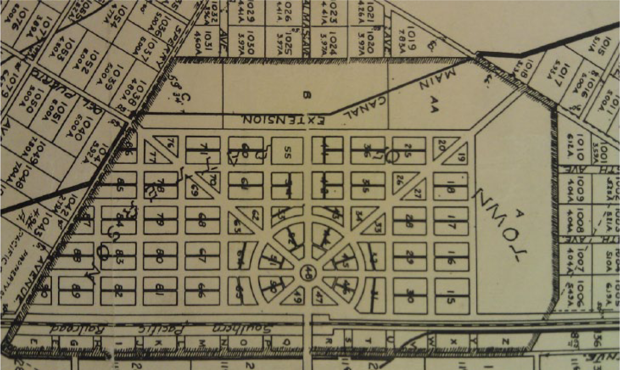
The essential form of Patterson’s radial plan is visible here. The Southern Pacific tracks run left to right (south to north) across the bottom of the image.
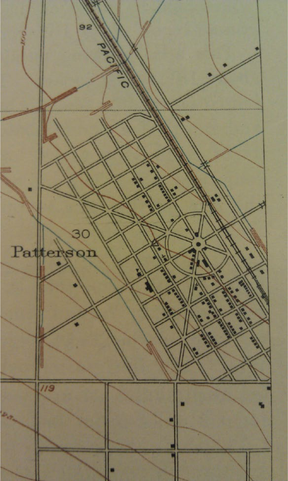
Another view of the plan shows the outer edges of town and the extent of building completed by 1916, when the Patterson and Western Railroad would join with the Southern Pacific.
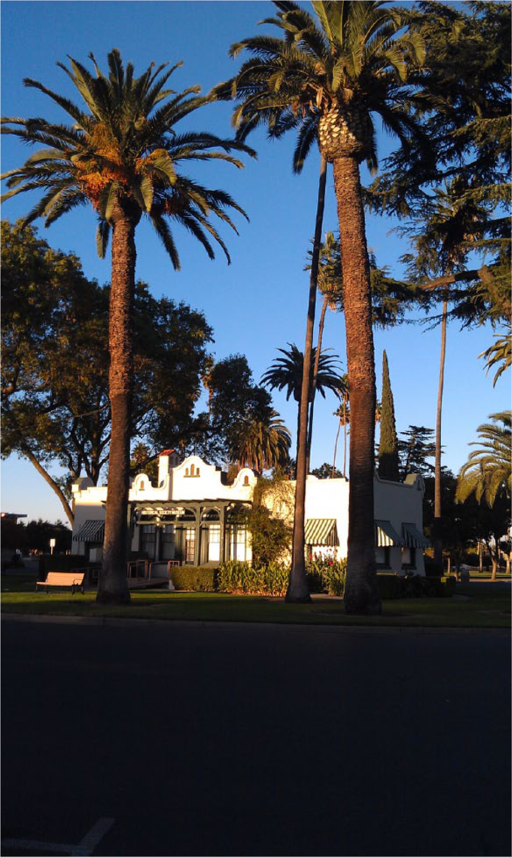
The “Center Building,” that is, the former land office of the Patterson Ranch Company, and its assemblage of trees. This building lies at the hub of the wheel.
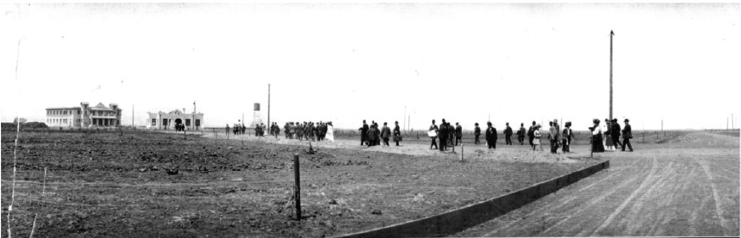
Prospective buyers, led by Ranch Company sales representatives, make their way from the railroad tracks to the Hotel del Puerto.
Where did Patterson of Fresno develop these spatial ideas? How, precisely, did he come to harness them to his speculative venture? The record is far from unambiguous on this count. But Patterson was a mobile, well-connected financier, a member of several exclusive clubs in Fresno and, crucially, San Francisco, the imperial attractor some eighty miles to the northwest. After the reordering of the nation’s capital according to the 1902 McMillan Plan, leading space-makers debated and implemented similar aesthetic programs in many American cities between 1900 and 1910, the period that the sympathetic historian William H. Wilson has identified as the “heyday” of City Beautiful thinking. 13 By way of Daniel Burnham’s unrealized 1905 plan, San Francisco was a key crucible of these debates—and all the more so once the notionally blank ruinscape deposited by the 1906 earthquake seemed to call out for wholesale remediation. 14 Patterson almost surely overheard and informally participated in such discussions. His project’s hinterland isolation, ex nihilo suddenness, and miniature scale may have struck onlookers as odd, but his monumental street geometries were hardly untested. Indeed, for Charles Mulford Robinson, the clearest systematizer of City Beautiful best practice (and the author of Oakland’s own Plan for Civic Improvement in 1906), specification of “the street plan”—be it radial, gridded, circular, or some combination thereof—must precede and constrain decisions about buildings, plantings, utilities, open spaces, and all the rest. 15 Thomas Patterson condensed and instrumentalized a set of very available, if in the first instance metropolitan, landscape forms for his rural, utterly speculative project.
Atop these reproducible forms, Patterson seems to have innovated in two key respects. “Mr. Patterson loved trees,” the local hagiographies all note, and his focal and axial palms, imported from Australia, were in place before anyone had so much as paved the roads. 16 He had all the significant edges and seams of Patterson Colony enhanced with decorative plantings: sycamores (and oleanders) lining Sycamore Avenue, the main north–south spine of the agricultural area east of the rails; eucalyptuses lining M Street, which marked the northern edge of the town plan; eucalyptuses and then, after 1936, palms lining the three-mile approach road, Las Palmas Avenue, modeled on Fresno’s prestigious Kearney Avenue and linking the former Patterson’s Landing with the newer, railroad-adjacent ceremonial center. 17
If the streets and trees amounted to Patterson’s prime aesthetic innovation, his irrigation system, itself a selling point, was the key gambit in the realm of technics. But that distinction, we must recognize, if analytically convenient, is overdrawn from the outset: the same water that irrigated the productive farmsteads (Figure 5)—alfalfa first, then wheat, then apricots, of which Patterson today claims “world capital” status—kept the parks and plantings green. Indeed, Adams’s uphill canal parallels Las Palmas Avenue; drivers today can still admire his handiwork, executed to the tune of $500,000, just a few feet below the shoulder. Aesthetics and technics, the more and the less visible dimensions of Patterson’s readymade landscape, were only ever interdependent. Monumental, outwardly static forms were presented as channeling and optimizing some below-the-surface potentiality, some life or energetics immanent to the landscape. City Beautiful thinking need not be read as antithetical to the City Practical (or City Efficient, or City Scientific) modalities that largely eclipsed it in the decade or so following the first National Conference on City Planning in 1909. We might even imagine Patterson’s project, laid out that very year, as a kind of fulcrum between these planning ethics. 18
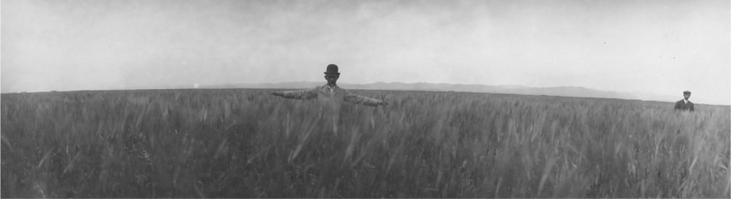
This photo, which depicts a man in a barley field, formed part of a publicity kit sent to would-be Pattersonians in the Midwest.
But the lift irrigation signified something even more basic for Patterson’s venture: its self-sufficiency and its continuing viability qua investment. The Valley’s Westside is, by consensus, unusually dry; Modesto, Merced, Madera, and their ilk, cities located along the main Southern Pacific line some fifteen miles to the east, outgrew Patterson in part, but only in part, because the railroad reached them first. 19 Land speculation in this part of the world, as David Igler writes, has hinged crucially on the question of how to “change the waterscape.” 20 Miller & Lux, the proto-industrial cattle ranchers headquartered in Los Banos, had gained control of the former Rancho Orestimba, directly to the south, and Patterson imagined they might oblige him by extending their canal system into his territory. 21 But they never did, and in 1908 command of a reliable water source, the very first condition of possibility for his instant town, was still an open question. In time, the Patterson Ranch Company could boast, “The canals, laterals, and ditches have been built. When a man buys a piece of land at PATTERSON . . . he buys with a completed plant at his service.” 22 With Adams’s novel infrastructure so firmly in place as to seem natural, the town could testify not only to its founder’s taste but to his expertise, not only to his art (which was improvised, at any rate) but to his underlying science. The company paper, founded in 1911 and printed in San Francisco (and still the town’s main weekly news organ a century later), bears witness to, and extends, this origin story in its very name: the Patterson Irrigator. 23
Within the physical frame established by this fanciful, palm-reinforced wagon wheel, population growth was rapid. Patterson’s company filed three additional tracts by 1912. Newcomers founded schools and churches in locations predetermined and set aside in the 1909 plan. The Western Pacific ran its Patterson and Western branch into town in 1916, respectfully steering a few blocks wide of the composed town center. Industries filled in the railroad swath by 1920: two lumberyards, a granary, Associated Oil, the Patterson Creamery. The town’s north side in particular prospered, filling with Craftsman houses on lots secured by deed restrictions that stipulated minimum cost. South of the circle and east of the tracks, home prices were lower. 24 That its designer and financier served as a “one-man planning commission,” as one commentator remarked on the occasion of the town’s Golden Jubilee, was in effect true, and the shape took precedence, whatever the consequences. 25
Thomas Patterson died in 1914, but his cousins and heirs seamlessly assumed control of the company, further promoted the town’s real estate, and defended the plan’s mini-monumental integrity from its critics. When a townwide survey in 1947, for instance, adjudged the tall palms “ugly” and “dangerous” and urged their removal—fronds would twist off and fall when subjected to heavier winds—Jack Patterson, Jr., heir apparent, tartly overrode the results, making explicit reference to the dictates of the “definite plan” and its ability to cultivate “a fine class of people.” 26 In so many everyday ways, the plan has remained available as an instrument of soft discipline, of argument, of aspiration materialized, of order. And it has remained largely intact: the hotel has burned and the land office now houses an active historical society, but Patterson’s circles and diagonals, and above all his trees, persist. 27
That said, the round downtown no longer anchors daily life for the most mobile Pattersonians in any significant sense. The plan’s aggressive gestures at centralization are now offset by less shapely suburban development sited beyond its original, tree-lined outer edge. Interstate 5, built in 1967 just three miles to the west, has, as in so many other American places, adjusted the local center of gravity—residential, commercial, symbolic. By the 1990s, the town had been resituated in a new, farther-flung configuration of flows prising apart spaces of home and work: by 1993, fully 62 percent of commuters beginning their day in the Modesto area were bound for Bay Area workplaces—Silicon Valley, the office parks of Alameda and Contra Costa counties, and even San Francisco, ninety miles away, “The City” according to an increasingly imprecise regional parlance. 28 At greater resolution than most jeremiads against the “formlessness” of sprawl permit, the polarities of contemporary Patterson can offer one window onto how the decenterings wrought by post-1945 suburbanization can efface, dislocate, relegate, or recode landscapes that, in their relative isolation, had once seemed bounded and thereby complete—and, here, in which morphology itself was officially a source of identity. 29 As the edge of town has softened, stretched, filled up with culs-de-sac and shopping centers aplenty, the ceremonial center has correspondingly shifted in function. Pedestrians are few. Many storefronts are dark. The well-maintained wedges of park space are occupied on the weekends—barbecues, birthday parties, church youth groups speaking Spanish and Portuguese—but they feel oversized, underused. The palms cast a welcome shadow amid the Westside’s dry heat, but the grassy flats rarely enjoy a moment’s quiet, for one of the main legacies of Patterson’s roundabout street scheme, granted the hegemony of the automobile, has been to hem in his open spaces with too-wide roads, counterintuitive intersections where spoke meets ring meets grid, and a determined population of motorists scarcely intent on ceding their right of way (Figures 6 and 7). For the pedestrian, the dominant feature downtown is asphalt, navigation is uneasy and frequently interrupted, and the ceremonial showpiece is most comfortably kept out of sight.
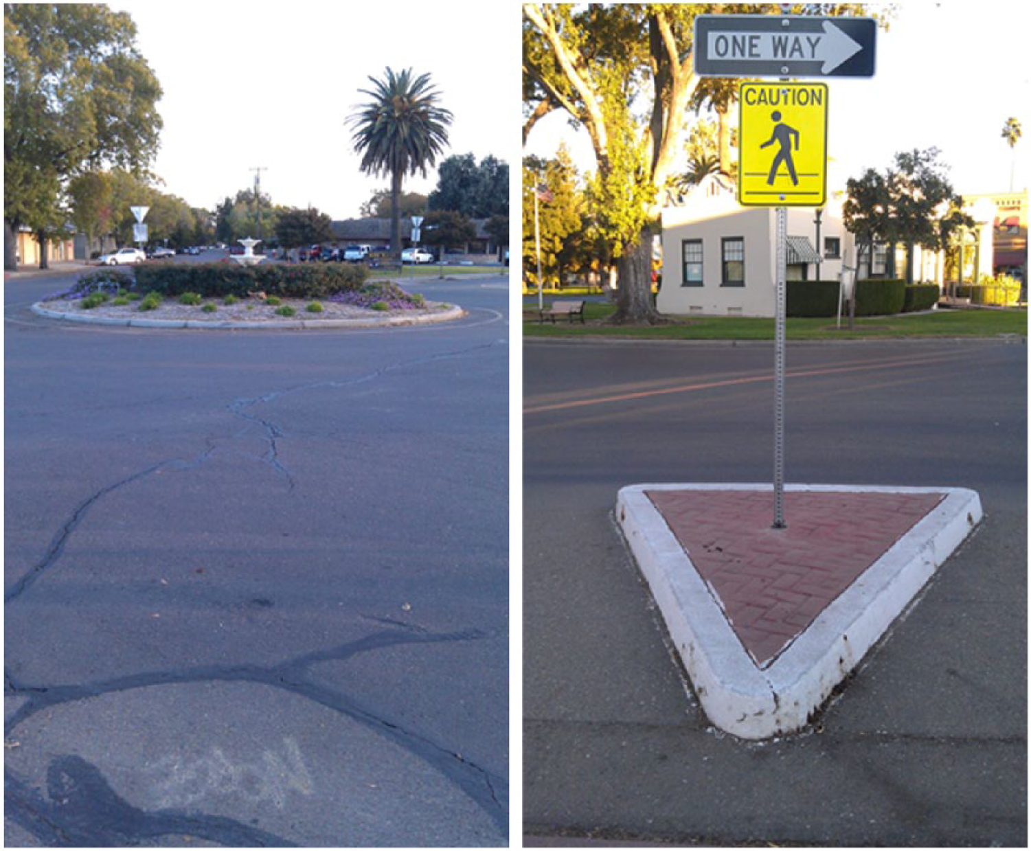
These contemporary photos attempt to capture the experience of navigating Patterson’s plan today on foot. Pavement predominates, dotted with islands both functional and decorative. Automotive circulation is very clearly favored.

From the very beginning, pedestrians have cut paths through Patterson’s plan in ways that ignore the overarching system of rings and radials. The image dates from the 1930s.
Order Itself
To interpret a town plan as self-conscious as Patterson’s, we do well first to understand how its designers and stewards themselves theorized its significance. Thomas Patterson and his assorted mouthpieces situated their project in a complex orrery of likeness and difference, attraction and repulsion. On the one hand, its very livelihood rested on having achieved sufficient similarity to—and positive associations with—the nation’s capital and other, larger Cities Beautiful (re)built at least partially in its image. 30 Comparison, analogy, recognition, recollection: only by sparking such cognitive moves in the mind of the visitor could this curious space tap into established, if never uncontroversial, class canons of neatness, rightness, and prestige. On the other, Patterson founded his bespoke colony after and in explicit opposition to the forms on display nearby, bundling up a knee-jerk hostility to the “monotony” of the grid with more pointed criticisms of the Dionysian pastimes these “undistinguished towns along the West Side” tolerated—and, pursuing this folk determinism to its limit, that their alienating checkerboards may actually have encouraged. 31 (Patterson Colony, it bears mentioning, was a dry town from its founding until 1933.) 32 The extent to which he ultimately channeled the McMillan Plan is debatable: Thomas Patterson may not have systematically studied the plan; he may not even have traveled to Washington. Washington contains circles but is not itself circular. It contains diagonals but not evenly spaced spokes that all converge at one focal point of articulation. 33 The Westside’s chroniclers visibly vacillate over how to situate his composition, and over what precise sort of likeness to grant it. One historian writes that Patterson was “emulating the layout of Washington”; for another, this was “something like the streets of Washington”; erstwhile Berkeley geographer James Parsons calls Patterson “reminiscent of Washington.” 34 Emulation, likeness, reminiscence—but not exact reproduction. The town’s “distinction” was double-edged, founded as much on rejection as on affirmation. 35
These considerations quickly complicate Patterson’s standing as a “model” community. In one neutral, basically non-causal sense, scholars often term model any instant settlement whose form, conceived as a whole, is subordinated to some more abstract concept, function, or normative ideal. 36 The carefully composed Pullman, for instance, over and against the more slapdash company towns of its era, fits this bill. 37 Valences with some rendition of the “ideal city” tradition are clear enough. 38 But if we take “model” at its word—and this has been very much the language used to justify Patterson’s landscape, past and present—some more specific operation seems to be at stake. True models exist to be replicated: they actively model further spatial experiments. They suggest, instigate, and propel. They are publicized—or perhaps they publicize themselves—as transferrable, modular templates for best practice. 39 (The demonstrable “completeness” of a project, it stands to reason, might be posited as one prerequisite to qualify as a full-fledged model or “object lesson,” another of the period’s watchwords.) 40 Yet flattery by imitation seems not to have been Thomas Patterson’s desire in the least: another, indistinguishable petit Paris, after all, would have undercut the singularity of his product. And nowhere do we see him trumpeting the intrinsic merits of this exact spoked design. Surely “Washington” or “Paris” could have been evoked with a slightly different street geometry, ensemble of trees, or cluster of buildings (probably not featuring Spanish-style roofing). Rather, curiously, Patterson is deemed a model insofar as it is modeled on someplace else—that is, is derivative.
The monumental street plan was never explicitly replicated. The irrigation system was. Towns to the north of Patterson, also beyond the reach of the Miller & Lux canals, reproduced Adams’s lift irrigation to tap the San Joaquin River, finding that, in addition to enabling agriculture, such trenches could cool the ambient air by as much as ten to twelve degrees Fahrenheit. 41 The colony’s distinctive engineering, then—just obliquely visible to the untrained eye—rather than its grandiose aesthetic linchpin, was the truly effective model in the long run. 42
The sort of beauty that City Beautiful landscapes, however tautologically, have seemed by their nature to evince presumes a very particular faculty of vision. Their harmony, their wholeness: these qualities, the argument runs, can be verified because they can be seen. Uncritical local histories of Patterson, boosterish in their own way, or prideful, or simply nostalgic, traffic in a similar vocabulary when they describe the founder’s thought process: Thomas Patterson was “a man of vision,” of “courage and foresight,” who “not only envisioned but brought into being” an appealing space. 43 Property speculation, after all, if etymology is any guide, suggests recourse to some originary visual register. This figurative manner of speaking, redolent of what one historian has called “ocularcentrism,” is widespread, within and without real estate’s peculiar visual culture. 44 When it connotes clairvoyance, it is easy to lampoon. But suspicious analysts, too, in overemphasizing talk of vision and visibility can sideline the import of infrastructure, a less conventionally aesthetic stratum of what we call landscape. Patterson the real-estate product encompassed both aesthetics and technics, art and science, beauty and efficiency—outward form and the vital capacities coursing through it. Each, differently, was packaged, promoted, and sold. 45 And each, today, infuses the local culture of memory: for every Irrigator, there is a copy of the historical-society bulletin, Spokes.
And on each count the landscape was demonstrably in order. Order is the master category here, capacious enough to scope over Patterson’s art and science alike. 46 It could be conjured in limitless ways. Patterson’s enforced policy of temperance, for instance, was moralistic only on the surface: citizens were absolutely free to ride the twelve miles to Newman for a drink, and did so with relish. But a dry town was neater, the banker thought, simply presented better to suggestible Midwestern visitors with money to invest, conservative in estimation if not always in fact. “The man personified control,” contemporaries said. “Nature was under control.” 47 Plans smacking of the City Beautiful, even at this peculiar scale, have been collated with a variety of programs, veiled or forthright, of social control. Certain observers were quick to assert the link between spatial and social order, between geometric form and some wholesale renewal or reformatting of “life” itself. Edward Hyatt, state superintendent of public instruction, wrote to the Irrigator after his 1914 visit, “Life with you is new and fresh. This is evidenced by the entire absence of the bedraggled old shacks that mar the landscape in so many older and larger places,” he continued, eagerly conflating “the newness of life, the freedom of view, the unity and oneness of social feeling.” 48 But Thomas Patterson’s own logic seems to have been simpler still. Order itself was his best sales instrument: an abstract order, content-independent, that could be reliably summoned, instinctively sensed, and, crucially, put on display as evidence of the investment’s underlying, while itself invisible, security. 49
The particularities of the physical plan, then, were always incidental so long as its stability, palpable if not straightforwardly visible, seemed likely to endure. But how did visitors look at the plan? How were their sightlines orchestrated? How, indeed, could newcomers, in an instant, possibly see the town as a whole? “Do not ask what can be grown at Patterson,” one print advertisement averred, “but go and see it growing.” 50 “Everybody that KNOWS goes. Everybody that sees is pleased.” 51 Piecing together these historical acts of looking is every bit as important as parsing the plan itself, and it is essential if we are to understand how, a studied composition of circles and lines, pavement and leaves, tiles and pipes could seem to stand for something more abstract. For it to induce these associative chains, what kinds of encounters had to be staged between flesh and stone? 52
Across Plaza Circle from the grass and the palms stood the Hotel Del Puerto—at first, by design, the only multistory building in town (Figure 8). Thomas Patterson, when he dropped by his colony, always slept in Room Fourteen. The one other purpose-built space it harbored was the showroom, where sales agents would promptly cart visitors to begin their day-long sales pitch. They would pore over maps and brochures, photographs and paperwork. But the decisive object on display stood outside the window: the shapely park–plaza, its radii exact, its edges crisp. Only from above was its comprehensive order, asserted in print, finally comprehensible. Citing the well-tempered town center—seeing, as it were, like speculators—visitors could infer the efficiency and productivity of the irrigated farmland, and, primed, confirm their hopes the very next day when Ranch Company chauffeurs would lead tours east of the tracks. Visions of Patterson’s “model” town traveled great distances—to San Francisco, to Fresno, to and from Omaha by excited word of mouth—but even right there in town, its imperial showpiece was always hard to get close to, officially meaningless unless viewed at a remove.
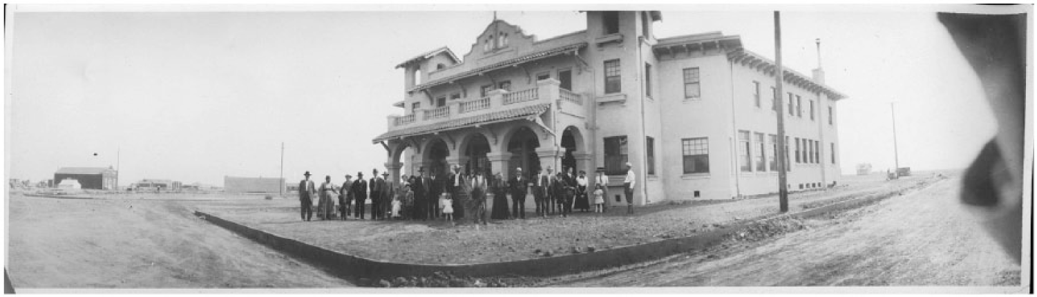
Prospective buyers gather in front of the Hotel del Puerto, ca. 1911.
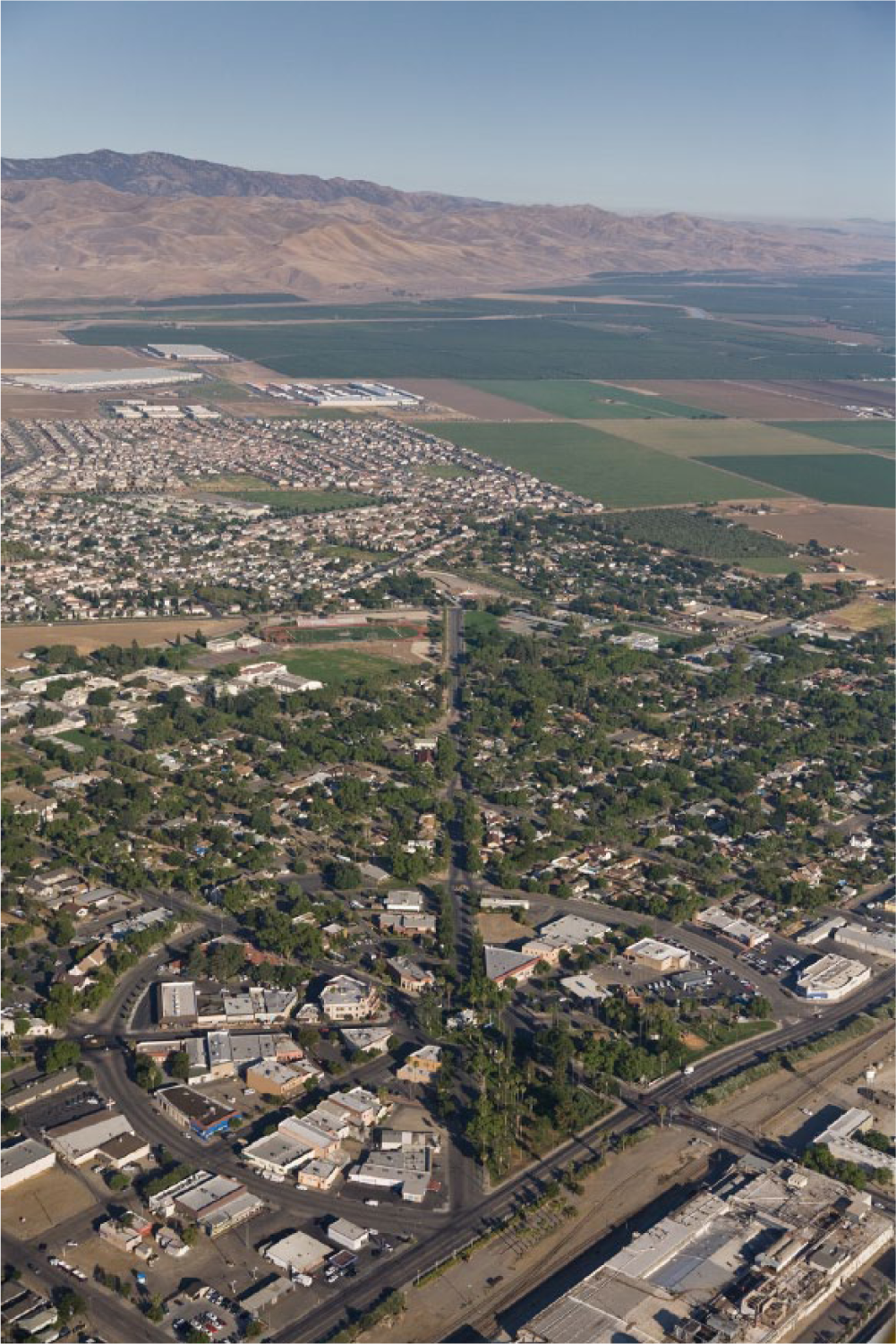
Patterson from the air, facing northwest, 2009. The original street plan remains intact. In the upper left quadrant, Walker Ranch and other subdivisions from the 1990s edge toward farmland. I-5 and the Diablo Range are visible in the distance.
Footnotes
Declaration of Conflicting Interests
The author declared no potential conflicts of interest with respect to the research, authorship, and/or publication of this article.
Funding
The author received no financial support for the research, authorship, and/or publication of this article.