



Abstract
The grain provisioning of the Ottoman capital city Istanbul for the subsistence of its considerable population, including the court, the military, and the religious institutions, was maintained through the same location on an extramural landing square along the wharfs of the Golden Horn from the mid-fifteenth century up until the mid-nineteenth century: the Unkapanı. This article addresses the urban architecture of Istanbul Unkapanı as an illustration of the Ottoman official distribution centers referred to after public weighing scales as kapan. Here, the buildings constituting the Unkapanı—the great magazine as the hall of the public weighing scale for grain, the mosque, and the tradesmen council house (dîvânhâne or çardak)—are identified and represented on the evidence of the original textual and visual sources, while the urban patterns through the landing square from the wharfs to the city gate are mapped.
Charles White, author of a three-volume book on 1840s Istanbul narrating the city via its commercial districts, may be one of the few Western travelers to reflect upon the significance of the wholesale markets for provisioning beyond the shopping attractions, such as the Egyptian Market and the Great Bazaar: We have yet to mention the kapans (stores or warehouses) principally reserved for wholesale trade. That of the corn-factors and meal-men . . . is called oon (meal) kapan . . . That of the timber-dealers (odoon kapan) is contiguous to the harbor . . . The above, with the stores of bal (honey), yagh (tallow), tooz (salt) and koorshun (lead), are the only kapans of any importance.
1
White was among the last witnesses of the historic wholesale trade centers of the Ottoman capital city, which were soon to be radically transformed. In the present day, there is scarcely any trace of these markets in situ to such a degree that the urban history of Istanbul’s kapans can solely be mentioned in reference to the original sources. This kind of a quest requires, in the first place, an introduction to the notion of the Ottoman wholesale markets.
The wholesale markets of the early modern Ottoman cities formed the loci of the two main pillars of the imperial economy: provisionism and fiscalism. 2 Provisionism defines the aim of the economic system as the availability of cheap, qualified products in abundance for the benefit of the consumers, where the state supervised the supply of the raw materials from the countryside and their distribution in the urban centers; in return, certain duties were levied as revenues for the treasury. In the cities, the state control over the wholesale trade was facilitated with the organization of specialized markets differentiated according to their specified items (such as fresh vegetables, grain, horses, livestock, raw silk, salt, slaves, wax, or wood), as well as due to the legitimate units of measurement. These were official weighing and distribution centers managed in the form of trusts (emanet), which constituted part of the city customs boundary, 3 whether or not located at the periphery. The wholesale markets in the Ottoman Empire took several names varying geographically in reference to the local trading practices 4 ; for the cities around the political center—in the Balkans and Anatolia—they were generally referred to as kapan and mizan, after the actual terms for the public weighing scales or steelyards. 5
How the kapans functioned may offer clues for understanding their spatiality. 6 After entering the city, the imported items were brought into the assigned weighing center by appointed porters (hammals) or the caravan heads (kervanbaşı). 7 In the kapan, after being weighed, qualified, and registered by the weighers (kapancı) and the official commissioners (emin), the merchandise would be tentatively stored in a depository until being traded to retailers under the supervision of functionaries and dealers. Other than market taxes, there were separate dues to be issued for the public weighing scale (resm-i kapan) and for the depository (resm-i mahzen). In addition, the market prices (narh) of the provisioning materials were set here. When the trade transactions were completed, the items could be circulated out of the kapan. 8
Kapans did not possess a fixed architectural typology; they were differentiated spatially according to the type of merchandise, their siting, and the utility of their exchange, as well as in respect to the investments in their architectural embellishment. The official distribution centers might be basically constructed as customs or market squares by the city gates or in the intramural sectors with surrounding service structures such as magazines, storehouses, workshops, cells, wooden sheds, or mere open-air storage areas. The offices of the market inspector or the head commissioner on such squares could be defined as a type of market house; these were kiosks called çardak, daire, or dîvânhâne. In a more advanced form, kapans could also be located in typical quadrilateral market buildings with large enclosed courtyards, referred to in Ottoman architecture as khans. 9 Concerning this context, the offices of the inspectors, commissioners, and weighers, as well as the depositories, would be placed on the ground floor in and around the courtyard. In certain cases, the khan-type kapan also differentiates itself with accommodation and offices for the merchants located on an upper level.
Istanbul was the main terminal wholesale market of the early modern Ottoman Empire. The provisioning of the capital city—as the abode of the imperial court, the religious institutions, and the military—was a key concern of the economy as well as a considerable source of revenue for the central treasury. The wealth acquired from the provinces was imported mainly by the seaways through the quays of the celebrated natural harbor known as the Golden Horn (Haliç). 10 Consequently, the urbanism of Istanbul demonstrates a complex customs boundary layout, as well as the complete variety of architectural types for the kapans. 11 Evliya Çelebi, an author of the seventeenth century, who is one of the most prominent sources on the topic, surveyed thirty-five different weighing scales and an equal number of distribution centers in the city, including the customhouses, mint, and the palace storehouses. 12 It is noteworthy that, in Istanbul, the number of kapans as large khans with enclosed courtyards was relatively limited. 13 When outside of the monumentality of this type of khan, the other kapans were primarily informal squares or market streets marked by the architecture of magazines, market houses, and other service buildings. Overlapping with the quotidian places of the commercial districts, land and maritime custom zones may be a characteristic of the wholesale markets of Ottoman Istanbul; however, that is also an obstacle for any research focusing on their architectural history.
This article addresses the urban architecture of Unkapanı, or Kapan-ı Dakîk, the official weighing and distribution center for grain in Ottoman Istanbul. Unkapanı and kapan-ı dakîk are generic terms, both literally meaning “the weighing scale of flour,” as well as denoting the wholesale markets were these scales were located. Istanbul’s unkapanı was formed as a landing square on the Golden Horn and would service the city at the same location for four hundred years, from the beginning of the Ottoman rule in the 1450s up until the mid-nineteenth century. Unkapanı is arguably the most celebrated of the wholesale markets in the capital city. Its significance as an official distribution center can hastily be substantiated as the epitome by Evliya Çelebi, who would simply note the kapans in an inventory of Istanbul as “Unkapanı and others.” 14 Following a similar conception, Unkapanı is here proposed as a key to comprehend the spatiality of the other kapans in Ottoman Istanbul.
The case of Unkapanı deserves further attention as an office of abundance sustaining one of the greatest early modern urban agglomerations. Grain provisioning of the capital city is among the main domains of Ottoman economic and social history, constituting a corpus that has been an extensive foundation for this study. 15 A very considerable share of the grain imports for the provisioning of Istanbul (that is, wheat, barley, oat, and millet) was directly destined to the Unkapanı landing square, where official superintendence distributed it to the bakers and millers of the city. Bakers and millers were important agents in provisioning as they were given the responsibility of keeping a certain level of reserves against shortages. Although limited in scope, another area of supply was through the state granaries, which will only be referred to here in terms of their topographical relations and typological comparisons with the grain scale.
Unkapanı has been widely mentioned as the major terminal of the grain trade and as an important neighborhood 16 ; however, the site has not been interpreted using an architectural history approach as a marketplace with its singular edifices. While aiming to fill this topographical gap in the urban history of Istanbul, this article also searches for the actual capacity of the grain distribution center. Today, there is almost no trace of the Ottoman Unkapanı Square beyond the name of the district where it once was settled; it will here be represented through textual and visual sources from the fifteenth century up to the 1940s. Maintaining a diachronic approach, this article is structured chronologically concerning major changes that occurred in different periods. The evidence from earlier periods consolidates Unkapanı’s continuous existence within similar architectural features while that of latter periods forms a basis for defining the general dimensions of specific buildings. Once the historical survey is displayed, the importance of the sixteenth century Unkapanı will be apparently singled out for the emergence of a grain distribution center typology in Istanbul. It is in the last part that a comparative analysis in respect to other Ottoman examples will be proposed, which will also be instrumental to clarify further some indeterminate issues about Istanbul’s unkapanı proper. Contrary to its importance to the sustainability of the capital city, Unkapanı district is marginally represented within the abundant visual sources on Ottoman Istanbul. Such limits of presentation about the architecture of the buildings will be evident throughout the text. Furthermore, it has to be stated that the multiple uses of the name unkapanı or kapan-ı dakîk for a gate, a landing stage, the grain weighing scale itself, a building, and a large district covering extramural and intramural neighborhoods form a major challenge in comprehending the topographical knowledge from the original sources addressing the wholesale market.
Around the Flour Gate: Foundation of Istanbul Unkapanı
Constantinopolis, taken by the Ottomans in 1453, had been transformed into their capital city in several decades when major administrative, economic, military, and religious functions were redefined by the imperialist vision of Mehmed the Second (also known as the Conqueror, r. 1451-1481). The establishment of a grain wholesale market institution in the city should have been realized simultaneously around the 1470s, when the prohibition laws of customs and weighing centers (Kapan Yasağı Hükmü) were declared. 17 These specified the issues of the kapans in very simple terms of transportation, weighing, taxation, and distribution and would be retained in essence, although with more articulated and specific versions, in the successive centuries. Where Istanbul’s unkapanı would have a lasting legacy as much as these laws, its foundation in the first decades of the Ottoman city can only be briefly represented here in reference to designation, location, proprietorship, and urban structure rather than architecture.
The commercial districts were among the first places restructured by the Ottomans in Constantinopolis/Istanbul. 18 On one hand, the core of the great bazaar constituting covered shopping streets around a trade hall (bedesten) was established at a central location (between the second and third of the so-called seven hills of the fortified peninsula) as a typical representation of the Islamic and Ottoman city model (Figure 1). On the other hand, the existing market neighborhoods along the Golden Horn (partially former Latin concession quarters) were reshaped while retaining their medieval Mediterranean multifunctional character composed of magazines, shops, and dwellings. The upper market was mostly reserved for high-value merchandise, while the lower market, on the axis “below the citadel” (tahte’l kal’a), was mainly for provisioning items. Correspondingly, unkapanı of the city was established within the lower market by the harbor zone, which extended one-and-a-half kilometers on the two sides of the maritime fortifications from the East to the West. Seven gates opened to the city along this liminal urban space, starting by the quay of the Great Customhouse, and these were mostly named after specific commercial items. 19 Respectively, there were a number of reserved landing stages designated according to the maritime gates, specific destinations, or imported merchandise. These were basic wooden embarkation platforms called iskele after the Greek word scala. On the other side of the Golden Horn, the northern shores fronting the townlet Galata displayed the same urban pattern of intramural and extramural customs and wholesale market zones. 20

Partial map of Istanbul showing 1860s.
The site chosen for Istanbul’s unkapanı was at the innermost point of the harbor zone around the former Byzantine gate of Mese or Plateia. 21 The history of the mentioned location in the Late Byzantine period does not provide clear evidence for functional continuity through to the Ottoman era. 22 However, the novel Ottoman names given to this city entrance clearly designate the assignment of this territory to the grain trade with a specific landing stage: the Flour Gate (Un Kapısı), the Landing Stage Gate (İskele Kapısı) or the Gate of the Flour Scale (Unkapanı Kapısı, Kapan-ı dakîk Kapısı 23 ; Figure 1). Furthermore, the vicinity was referenced after the grain scale, and there was even a specific neighborhood called Unkapanı. 24 The quay fronting the Flour Gate presented several topographical advantages for the import and distribution of grain. It was at a section of the harbor where the currents of the inlet were calmer and where it was deep enough to board a deck; such a shore was suitable for the long-term moorings necessary for the unloading of large grain ships. Moreover, the thoroughfare from the Flour Gate opened to the third valley (between the third and the fourth hills) that was one of the most even slopes up from the shore favorable for the distribution of large quantities of merchandise. The ridges overlooking the Golden Horn were predominated by monumental religious complexes from the fifteenth century onward, as well as with palatial enclaves, barracks, and markets, which were interrelated through several arteries forming the thoroughfare later known as the Divan axis. 25 The valley street from the Flour Gate terminated at its crossings with this main axis of the city at two points. The eastern branch passed through the Vefa Square—a market and depository for straw—and reached the street by the Old Janissary Barracks that would later be known as Kemeraltı or Direklerarası. On the other crossing were the Horse and Saddlers Markets (Atpazarı and Saraçhane) that were founded by Mehmed the Second. When the third valley became structured as one of the major areas for the small milling industries, the relation of the Horse Market with the millers and Unkapanı would further emerge as practically meaningful because most of the mills in Istanbul operated by horses up until the nineteenth century. 26
It is in the first decades of the Ottoman rule that the premises around the Flour Gate were declared primarily as imperial property. In fact, the entire thin shoreline between the fortifications and the harbor, called “the outside of the walls” (hâric-i kal’a), was donated by Mehmed the Second among the endowments of the Ayasofya Mosque, which had been recently converted from the Byzantine Hagia Sophia. 27 The endowment registers are important sources for identifying certain locations in the city. Here, the extramural zone of the Flour Gate is referred to as the neighborhood of the Landing Stage Gate (İskele Kapısı Mahallesi). Among the other properties mentioned, there are single- and two-storied structures, as well as several cells, which might be small masonry magazines from the Byzantine period. 28 Moreover, the immediate vicinity of the Flour Gate was noted as a market street (sûk) constituting thirty-one shops that was “acknowledged and famous in all of the city.” 29 Although the registers specify extramural buildings, there is no such note for this bazaar. How the Flour Gate market street was actually related with the grain wholesale market cannot be ascertained for this period. 30
In another account of the Ayasofya Mosque endowment dating to 1490, the time of Bayezid the Second (r. 1481-1512), Unkapanı is registered clearly among the properties of the pious foundation and defined further as “two flour storehouses.” 31 Until the seventeenth century, there was a grain magazine referred to by Sultan Bayezid at close vicinity to the Flour Scale Gate along the Tekirdağ landing stage. 32 This quay was named after the port town of Rodosto in Thrace—the closest of the grain supplying regions—and would develop as a supplemental site of Unkapanı in the form of a mixed-use urban tissue. 33 One structure that can provide a comparison for the late fifteenth century Unkapanı storehouses was the magazine of the great maritime customhouse at the outermost section of the harbor in Eminönü, which is one of the buildings listed in the Ayasofya registers (Figure 1). Also called the weighing scale of the customs (gümrük kapanı), this was a freestanding masonry building, roughly square in plan, with a large hipped roof perhaps marked by a lantern in the middle. 34 Some sources attribute the foundation of a Tradesmen Council House (Ehl-i Hiref Dîvânhânesi) 35 in Unkapanı to Mehmed the Second who had started a tradition of a market inspection performed on every Wednesday by either the sultan himself, the grand vizier, or the head judge (kadı). The Council House in Unkapanı would continue to function as the main seat of the grain market inspector as well as a base for the guilds of bakers and millers.
Within the earliest city views of the new Ottoman capital, there is no clearer image of Unkapanı than the notation of the Flour Gate. 36 A copy of the Buondelmonti map depicting the city in the early 1480s is an exception showing a structure that may be related with the grain market: a high fortification tower labeled Torre di Medio, with a pinnacle and stairs leading to a gate 37 (Figure 2). This caption has been translated by Çiğdem Kafesçioğlu as the “Tower of Wheat,” which may be referring to the use of a fortification tower by the Flour Gate as a storehouse. The Ottomans utilized some of the bastions as granaries, the most significant one being the Leaded Magazine (Kurşunlu Mahzen), which will be mentioned in the next section. However, as far as this article is concerned, there is no other reference to a grain storehouse in a bastion around Unkapanı for the later periods. 38 Nevertheless, it is known that the maritime walls were partially sided by buildings that were mostly small shops along the two parallel streets on the two sides of the fortifications.

The Golden Horn in the late fifteenth century.
Murad the Second (r. 1421-1451), the father of Mehmed the Second, had constructed the grain distribution center in Edirne (the former capital city of the Ottomans), the Grain Khan (Tahıl Han), probably as a marketplace with an enclosed courtyard. 39 There is no evidence to suggest that the initial unkapanı in the new capital city was a similar structure. A council house, two storehouses by the landing stage, an intramural market street, and maybe a bastion used as a granary, all point to the fact that Unkapanı was initially founded on imperial possessions as a weighing and distribution center occupying the open spaces around the Flour Gate.
Matrakçı Nasuh’s map, dated approximately 1537, is a visual résumé of the early Ottoman capital city and represents the buildings on the harbor zone of Istanbul proper as an overlapping tight fabric in front of the city gates, which is a very different genre than that seen on other parts of the map, but it does not provide specific evidence for the Flour Gate area (Figure 3). 40 In fact, this map more precisely depicts the Galata quay across the Golden Horn with the recently constructed İbrahim Pasha Mosque at Yağkapanı (the weighing scale for tallow), which had been the customhouse for this sector since the first years of the Ottoman rule. 41 Also known as the Yağkapanı Mosque, an endowment of the celebrated grand vizier of Suleiman the Lawgiver (r. 1520-1566), it was a prayer hall raised on magazines and covered by a hipped roof. The view also shows the magazine of the customs adjacent to the mosque. 42 The depiction of Matrakçı for Galata Yağkapanı is significant for designating the urban model and the scale of monumentality for the Unkapanı quay across the Golden Horn in the subsequent decades of the sixteenth century: a customs square predominated by a mosque and a magazine. While in the later centuries at the harbor zone of Istanbul proper, intramural sectors would be partially monumentalized from Bahçekapı (Gate of the Garden) to Odun Kapısı (Gate of Wood) with large congregational mosques, khans, and shopping streets, 43 the extramural strand preserved its quotidian multifunctional character with few monumental structures. The continuity of the urban fabric rather than architectural monumentality defined the urban history of Ottoman Istanbul’s harbor from the initial stages onward. In an area constantly devastated by major fires, reconstructions have been the primary key to permanence.

The maritime customs zone on the two sides of the Golden Horn by early sixteenth century.
Mother of the Magazines: Unkapanı in the Age of Sinan
The urban architecture of Unkapanı as an extramural weighing and distribution center can be concretely depicted at the earliest in reference to the original sources dating from the second half of the sixteenth century. In this era, two buildings governed the landing square: the great magazine of Unkapanı and the Congregational Mosque of Süleyman Subaşı, also known as the Unkapanı Mosque. In fact, there is enough evidence to suggest that the magazine and the mosque were built, or rather reconstructed, under the supervision of the Master Architect Sinan, the most celebrated of the court architects of Ottoman classical architecture. In the three books dedicated to Sinan’s achievements written in the late 1500s by Sai Mustafa Çelebi, the Magazine of Unkapanı (Unkapanı Mahzeni) is noted among more than 400 buildings and complexes attributed to the master. The most detailed account of the edifice in this context is to be found in a copy of Tuhfetü’l Mi’mârîn: “. . . the great warehouse [ümmü’l-mehâzin] built in Unkapanı, which was rebuilt after a fire.” 44 Ümmü’l-mehâzin, literally meaning mother of the magazines, can both point to the considerable size of the building or the vitality of the trade within for the abundance of the capital city. Moreover, the note on the reconstruction is itself a proof for the existence of an earlier grain magazine on the site where the storehouses from the time of Bayezid the Second, mentioned above, can be recalled as the only relevant precedents. The adjacent mosque is also included in Sinan’s autobiographies, twice in fact. Taking into account the dates of the donor Süleyman Subaşı’s office as a municipal police chief and his other religious endowments, the first mosque could have been constructed by the late 1540s. 45 This building had to be rebuilt—most probably together with the magazine—after a conflagration, the date of which is undetermined but should have taken place between 1569 and 1576. 46 Nevertheless, a date of reconstruction for the Unkapanı Magazine may be proposed after an account of expanses for the “enclosure” of the great grain storehouse (anbâr-ı kebîr-i gıllât) in Kapan-ı dakîk dated to September 1575. 47 The list of imported materials in this account includes a wooden column, six roof beams, wooden planks, building stone, metal nails, and clamps as well as a very considerable amount of felt. These were either part of larger expenditure for the reconstruction project of the magazine or were simply referring to another minor restoration. In any case, there are two city views that precisely depict the Unkapanı quays before and after the reconstruction.
The first view is the panorama that Danish painter Melchior Lorichs drafted in 1559, now in the archives of the Leiden University Library 48 (Figure 4). In this prospect, the Flour Gate (noted as Meel Thor) is represented with a high fortification tower. On the left of the Gate, the first Süleyman Subaşı Mosque is depicted as a large building covered with a square hipped roof and a high minaret. The part of the quay in front of the mosque is full with smaller structures, and there is one enclosure defined by wooden palisades that may be referring to an open-air storage area of the wholesale market to serve the ship cargoes right before they enter the weighing scale. These types of transitory demarcations for different cargoes were important instruments of the maritime ports, which can be observed in the Ottoman harbor and Unkapanı up until the twentieth century. On the left of the mosque, the city walls are depicted as being shadowed by a number of ships embarking from the prow, over which is noted meelhaus, meaning the flour hall probably after the Unkapanı Magazine. However, unfortunately, this hall is hidden behind the grain ships in the depiction of Lorichs, who, at least in this section, preferred showing a real scene of the busy grain wharf instead of an ideal landscape.

View of Unkapanı by the mid-sixteenth century.
The Unkapanı shore after the fire and the reconstructions can be observed in an anonymous panorama from 1590, now in the archives of the Austrian National Library 49 (Figure 5). This picture is specific to display the first known conspicuous image of the Unkapanı Magazine: a large rectangular hall parallel on its longer side to the seashore and with a high-hipped roof. It has to be underlined that the Unkapanı Magazine is the greatest of all the structures on the extramural harbor zone represented in this prospect. Here, the roof of the edifice was marked dark blue, probably denoting that it was lead covered. Either domes or pitched roofs, to be covered by lead was a key to monumentality for any building in Ottoman classical architecture. In fact, the prominent roof of the Unkapanı Magazine would also be its trademark as the edifice was also referred to as the Leaded Weighing Scale (Kurşunlu Kapan). 50 In the same view, there is a single-story annex covering the whole façade of the magazine toward the quay, over which are several clerestory windows. The Süleyman Subaşı Mosque is depicted adjacent to the west side of the magazine as a smaller building with a square hipped roof. The rebuilt religious building, behind a group of modest structures, seems to be similar to the first one represented by Lorichs. The architectural ensemble of the magazine and the mosque in Unkapanı, as shown in the 1590 panorama, is functionally meaningful because the religious buildings on the port might also act as seats of the judges during trade transactions. Remarkably, Azapkapı, the part of the Galata quay across Unkapanı, was also embellished with a congregational mosque around the 1570s by the grand vizier Sokollu Mehmed Pasha, which is a mid-size, domed prayer hall elevated over magazines that is still standing today. 51 Unkapanı and Azapkapı Mosques marked the terminus of the wharfs of the Golden Horn on two sides (Figure 1).

View of Unkapanı by the late sixteenth century.
Although Istanbul Grain Magazine’s renewal is related to a fire, its reconstruction in capacity might have reflected the rising concerns for the grain provisioning under the conditions of a shortage embracing the Ottoman Empire throughout the second half of the sixteenth century. 52 The precautions against grain shortage seem to be immediately reverberated in the capital city in the construction of a new state granary at the entrance of the Golden Horn by the Galata side, which was again executed under the supervision of Master Sinan and named as the Leaded Magazine (Kurşunlu Mahzen 53 ; Figure 1). In fact, this granary project was no more than the conversion of a former Byzantine fort tower within Galata fortifications that was composed of a rectangular enclosure raised over an undercroft. A very large hipped roof ventilated by roof windows was constructed to cover this enclosure, which was plated by lead—hence, the name, the Leaded Magazine. 54 There may have been several stories within the storehouse supported by wooden posts as well as roof trusses. 55 Kurşunlu Mahzen functioned as a granary for 100 years until it was transformed into the customhouse of Galata. Here, the building should be considered for a possible comparison with the roof of the Grain Magazine in Unkapanı as well as for its interior structure. Nevertheless, the Galata Granary was a state storehouse against shortages whereas the Unkapanı Magazine was a depository for the grain imports during trade transactions.
The sixteenth century, in the context of Ottoman architecture, has been recently called “the age of Sinan” by art historian Gülru Necipoğlu after the impact of the master’s oeuvre on the emergence of a classical imperial style. 56 The greatest of all the kapans in Istanbul is among the indeterminate achievements of this epoch. Indeed, as will be represented below, Unkapanı of the age of Sinan would be long-lived.
Through the Veil of Grain Ships: Unkapanı of the Seventeenth and Eighteenth Centuries
The buildings in the anonymous view of Unkapanı from the late 1500s can be followed in the visual documents of the later two centuries along with the changes in the architecture of the mosque on a similar blueprint. The best visual depictions of the area from the seventeenth century are the copies of the Piri Reis’s Kitab-ı Bahriye, where the weighing scale magazine is represented as a building with arches on the ground level, windows at a second level, and covered by a large hipped roof 57 (Figure 6). The arches on the ground either symbolize that the grain magazine was related to the quay with many entrances or they refer to a row of shops. The street leading to the city gate (Gate of the Weighing Scale) from the quay is marked behind the mosque, where the religious building is shown with a dome different from earlier depictions. Evliya Çelebi, writing in the same era, states that “as it was built on the waterfront,” the Unkapanı Mosque was destroyed and rebuilt by a new donor named Kara Çelebizade as a domed prayer hall raised on magazines, which like the former mosque had a long minaret with no equal in Istanbul. 58 Kara Çelebizade resembled the previous donor of the Unkapanı Mosque in having a relation to the wholesale trade since he was the head judge of Istanbul around the year 1634 and responsible for the inspection of the markets. The elevated mosque typology was specifically applied in the harbor and busy commercial zones, where shops were utilized as sources of revenue and the shrine was freed from the hub below. In a similar manner, the Unkapanı Mosque’s shops integrated the ground floor of the edifice to the wholesale market.

View of Unkapanı by mid-seventeenth century.
Moreover, the map in the Kitab-ı Bahriye depicts a major wasteway flushing into the harbor near Unkapanı; this location at the eastern end of the Tekirdağ landing stage was called the bokluk after a major open sewer (Figure 6). The wharves by the harbor were places for deposing urban waste. The state prohibited, on occasions, this garbage for sanitary reasons. The hydraulics of the Golden Horn currents washing up dirt and waste in its deep waters have been marveled at by Western travelers. 59 Nevertheless, during the four hundred centuries surveyed here, a limited amount of infill should be taken into consideration for the Unkapanı landing square, forming a small projection toward the inlet. What Evliya Çelebi meant “as being built by the waterfront” should refer to the weakness of the infill land, which posed structural problems for the buildings and is an important contextual characteristic that defined the architecture of the harbor structures. Whereas, the basic wooden landing platforms, such as the ones depicted in the Kitab-ı Bahriye map (Figure 16), perfectly adapted to the changes on the waterfront. There are abundant documents in the Ottoman Archives on the occasional reconstruction of the wooden landing stages of the grain wharf. 60
The same depiction of a large hipped, roofed magazine and a mosque is to be found in a view of the city from the end of the seventeenth century by the Dutch traveler Cornelius de Bruyn, who identifies the Unkapanı as Oun Kapan and translates it as the Meal House 61 (Figure 7). If the note of Lorichs from a century before about the magazine as the Meelhaus is remembered, it can be stated that to the eye of the Western traveler, the Unkapanı Magazine was comparable with the large enclosed grain market halls of their homelands. In the European grain halls, sometimes, the high-hipped roofs served the purpose of grain storage, whereas the lower sections were trade halls and shops. 62 Whether the Unkapanı Magazine had a similar functional organization will be further investigated below.

View of Unkapanı by late seventeenth century.
Two local authors of the seventeenth century give valuable descriptions on the workings of the wholesale market that is observed in the images. Evliya Çelebi, who was, indeed, a native of the neighborhood, states that the Unkapanı was a great trust with its officials and porters. The porters had superhuman strength and took their energy from a beverage called boza, produced of fermented millet, which was sold in many specific shops in the vicinity. Then, the author gives a very rare account of the actual public weighing scale, the kapan: the porters carry enormous bulks of grain in sacks [seklem] weighing seven or eight Ottoman kantar 63 [350-400 kg]: “when they load it on the weighing scale, the spindles start whistling in great hums.” 64 Once inspected in the grain scale, the merchandise could be carried away. Unfortunately, the exact place where the spindles whistled was not specified.
Perhaps the most important contribution of Evliya Çelebi’s Seyahatnâme to this research is not in the first volume on Istanbul but in the third one covering his travels to other cities. In the sections devoted to the rise and fall of the grand vizier Melek Ahmed Pasha, of whom he was a protégé, Çelebi narrates a market inspection realized on the Ramadan of 1650 in the capital city, starting from Unkapanı and progressing to the market house (çardak) in front of Dungeon Gate (Zindankapı) on the East. 65 At the grain market, he clearly states that the grand vizier gave a price to bread in assembly with the ship captains, bakers, and the buyer-up at the Council House (dîvânhâne) of Mehmed the Conqueror, located near the Unkapanı Magazine. This is a clear evidence for the fact that the Dîvânhâne was an independent building other than the magazine.
Another important source of the seventeenth century, Armenian Istanbulite writer Eremya Çelebi Kömürcüyan states that the quay of “the Leaded Weighing Scale” was always full with loads of barley and grain, while the agent of the İstanbul Efendisi (judge of Istanbul), naib, stayed at this place the entire day keeping up with the registers. 66 The bakers—the majority of whom, according to Eremya, were Armenians—were to be present at the lonca, with the exception of Friday and Sundays out of respect for the holy days of the Christian and Muslim merchants. This lonca should be referring to the tradesmen council house, where the price of bread was determined. The buyer-up mealmen were filling their magazines, which were situated on both sides of the Leaded Weighing Scale, with grains for the winter; these magazines—such as the ones below the Unkapanı Mosque—should be found in the extramural urban fabric from the Tekirdağ landing stage to the Unkapanı Square. The author depicts that the shore was occupied with grain ships coming from the Black Sea and anchoring in rows of two or three lanes. In fact, starting with the eighteenth century and the emergence of picturesque views, these would be veiling the Unkapanı quays in any realistic depictions, forming an obstacle against the determination of the buildings of the wholesale market and the related structures. 67 Where were the entrances of the magazine and the mosque; and were they related? What was the relation of the council house (dîvânhâne or lonca) with the magazine, considering that the duty of the naib’s office was to register the weighing and distribution of grain as well as controlling the price of flour and bread? Which streets were used for the distribution of grain after they were let out of the kapan? How were the magazine and the city gate related? And, maybe most significantly, where exactly was the public weighing scale located? The topographical facts about these relations are, ironically, blurred within the busyness of the waterfront square.
Yet, there are numerous official books on the registers of the public grain scale in the Ottoman Archives. Among them, one states that the steelyard of Unkapanı (mizan) belonged to the pious endowment of the Enderun Mosque (also known as the Mosque of the Eunuchs) within the major residency of Ottoman sultans, the Topkapı Palace. Then, the weighing scale dues were issued as revenue for this foundation. 68 The same document specifies that the grain scale was located at a place called unluk in Unkapanı. In the sources of the later periods, unluk (literally the place of the flour) is simply used as the name of the streets surrounding the Unkapanı Magazine, 69 which probably referred to the epithet of the enclosed edifice. In that case, the steelyard that Evliya Çelebi described was certainly within the Leaded Weighing Scale that acted both as a market hall and a depository. Unfortunately, there is no visual source for the actual grain scale of Unkapanı. The only large steelyard in Istanbul known to a certain degree was the one near the courtyard of the Balkapanı Han (the weighing scale of honey), which was described in the early twentieth century as a large weighing device of extreme precision supported by a wooden structure. 70 The weights of this type of steelyard could be of stone, as noted in the prohibition laws. 71
The Unkapanı Mosque was restored in the early eighteenth century by the head eunuchs of the Palace: Beşir Ağa and his successor having the same name. Should the interest of the head eunuchs of the Court for the restoration of the Unkapanı Mosque be related with the donation of the grain scale to the Mosque of the Eunuchs within the Topkapı Palace? In any case, in this period, the upper structure of the Unkapanı Mosque was remade from a domed structure to, once again, a hipped roof plated with lead. The replacement of the dome with a hipped roof such as the original built by the master, Sinan, may point to the structural problems posed by the infill ground of the landing square mentioned by Evliya Çelebi. It is rather the height of the minaret—with no equal in Istanbul—than the upper structure of the mosque that challenged this local context. At the same time, the head eunuch had ordered the construction of an imperial prayer hall (mahfil-i hümayun) as an annex to the mosque, probably facing the harbor side. 72 Other imperial halls and kiosks were built in the seventeenth and eighteenth century by the mosques on the waterfront and in the customhouses that functioned equally as places of observation for the sultan of the economic activities and the harbor. 73 These buildings symbolically marked the constant gaze of the state head over the economy, whether his person was actually on the spot or not. After the construction of the imperial prayer hall by the early eighteenth century, the symbolic markers of the imperial surveillance on the grain market were multiplied in addition to the dîvânhâne and the Unkapanı Gate. Indeed, this was the beginning of a century when the sultans would have to intervene more on the grain provisioning of Istanbul.
The Fountain and the Çardak: Unkapanı after the Grain Inspectorate
The eastern sector of the Great Arsenal on the Golden Horn adjacent to the western end of Galata, referred to as Tersane-i Atîk (Old Arsenal), was converted to an area of state granaries in the early eighteenth century. These granaries, constructed in successive stages, were single-story, long and thin, row storehouses divided by masonry walls and with separate pitched roofs. 74 Significantly, the Arsenal storehouses were directly across from Unkapanı and would function in correlation with the grain weighing scale. In times of shortage in the city or when there was abundance in the storehouses, the grain reserves were transferred to the kapan for distribution (Figure 1).
During the late eighteenth century, the state revised its grain provisioning system; a new grain inspectorate, Zahire Nezareti, was established under the reign of Selim the Third (r. 1789-1807) in 1793. 75 The state intervention over the grain wholesale market was expanded by the addition of new storehouses near the Arsenal granaries. All the same, this economic restructuring did not have a radical spatial impact on the actual place of grain distribution. While there was a series of infrastructural projects transforming the vicinity in the intramural and extramural sectors, the Unkapanı quays retained their architectural heritage from the sixteenth century, with only minor changes tangential, surprisingly, to the “remaking of İstanbul in the nineteenth century.” 76
After the foundation of the Inspectorate, the historic Unkapanı Magazine was still acting as the wholesale market hall. Indeed, the building can be observed in the panorama of Henry Barker realized in 1800 (a source celebrated for its precision) as a rather insignificant building where the mosque can hardly be identified 77 (Figure 8). With the exception of some single-story structures attached to the magazine, the narrow quay was vacant. The left side of the magazine was also an open space that extended toward a building by the waterfront with two floors and an inclined roof. In the same year as Barker’s depiction, Sarkis Hovhannesyan noted that tiles had recently replaced the lead plates of the magazine. 78 It is an ironic fact that while the state was constructing novel granaries with lead covered roofs (that is, Paşalimanı Granaries in Üsküdar on the other side of the Bosphorus), the main storehouse of the grain trade in Unkapanı was architecturally undermined; the Leaded Weighing Scale was no more. Nevertheless, the grain ministers and other officials showed their presence in the Unkapanı area with their construction activities. For instance, the grain minister Hacı Veli Ağa restored the Unkapanı Mosque and the Unkapanı Gate after a fire. 79 The interest of the grain minister in the restoration of the gate once more underlines the function of the entrances of the fortified city as final points of economic control. Moreover, a freestanding fountain named after the Unkapanı Square was donated by Kapani (the weigher) Hafız Ahmed Ağa, approximately in the 1810s, as illustrated in a waterway map from 1812 to 1813 by Engineer Hasan (Figure 9). Although transported slightly from its original location, the fountain is the only surviving relic in the present day from the Ottoman Unkapanı Square. 80 It is formed of a prismatic mass with rounded edges and is totally faced with white marble. Originally, there was a central dome marking the reservoir over a projecting pitched roof. The fountain was placed parallel to the seashore at a slight angle to the other structures on the square; the only fountain tip placed in the center at the foot of relief arches was facing the waterfront (Figure 12). Shirine Hamadeh argues that the meidan fountains freed from religious complexes had a new secular function after the eighteenth century. 81 The Unkapanı Square fountain perfectly exemplifies this statement, its whiteness being in deep contrast with the quotidian realities of the congestion of merchandise and of porters, all covered with the dust and dirt of the Grain Square.

View of Unkapanı in 1800.

Plan of Unkapanı in 1812 to 1813.
In the period of the Grain Inspectorate, the superintendent, who was responsible for Unkapanı, continued to hold the old title, naib. The map by Engineer Hasan is also significant to be the first document to specifically locate the office of the naib (daire) on the quay adjacent on the East to the recently constructed Unkapanı fountain. Here, the daire is pictured as a small rectangular structure parallel on its longer side to the sea with two projections 82 (Figure 9). This office by the quay could perhaps be interpreted in continuation with the council house dating to the fifteenth century, taking into account several reconstructions. With this information, Barker’s view can also be reconsidered. Can the building he depicted to the left of the magazine on the waterfront be the office of the naib (Figure 8)? Why would the office of some official who would give price to bread for the consumers in the city be located on the edge of the waterfront? This is rather meaningful when it is considered that the shipping papers of the grain vessels for importing the grain from the provinces were issued here, as well as the fact that the captains importing the grain were also one of the agents who sat in the council house to determine the price of bread with the bakers and millers. In that sense, maybe, the dîvânhâne was not just metaphorically but actually located between the maritime world and the bakers of Istanbul.
As far as this research is concerned, the only detailed architectural account on the office of the naib is from the time when the system of the Grain Inspectorate had been abolished: the restoration survey of an imperial property called çardak in Unkapanı, issued by the head of the building storehouses, Raif Efendi, dating to 1873 to 1874. 83 Çardak is a quotidian term in Ottoman used for a market house other than daire or dîvânhâne that connotes state ownership. In any case, the Çardak of Unkapanı was a two-story structure with a pitched roof covered by tiles. The majority of the construction was of wood, lath, and plaster with the exception of a masonry wall on the ground floor (Figure 10). The offices were situated on the upper floor (composed of five rooms, a small hall [sofa], and a lavatory) and had glazed windows. The lower floor was formed of two shops, one of which was a coffeehouse. In addition to a lavatory, and a stable, there was also an open hall on the ground floor, probably connecting with the stairs to the upper level. The coffeehouse—one of the celebrated shops in the city as a major meeting point in the harbor 84 —was a simple room with a cooking corner and a seating place (divan). As far as the building survey is concerned, the entire building was not bigger than ten to fifteen meters. Certainly, inspector offices raised on columns or other service structures with a panoptic view of the markets were not only specific to the Ottomans. The market houses of the Early Modern European commercial squares displayed a very similar typology. 85 In these examples, the official scales are placed in relation to the market house or sometimes within a separate market hall. With a similar organizing principle, in Unkapanı, the çardak gazed over the landing square where the grain scale magazine acted as a wholesale market hall.
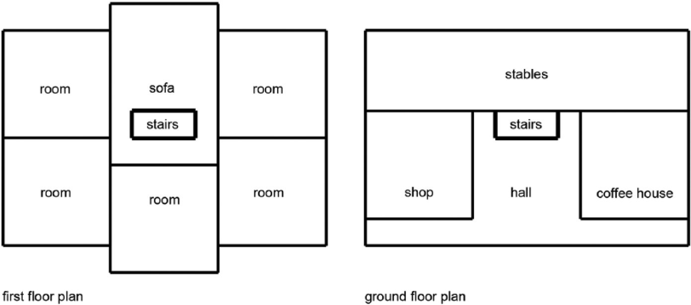
Hypothetical plans of the Çardak.
Unkapanı Abridged, Industrialized, and Converted: Latest Traces of the Landing Square
The construction of the first bridge over the Golden Horn in 1836 from Unkapanı to the Azapkapı on the Galata side is one of the most significant changes of the nineteenth century. Then referred to as the New Bridge (Cisr-i Cedit), it was a wooden floating structure.
86
The bridge transformed the Unkapanı Square from the end point of the maritime port to a vehicular node. Consequently, the Ottoman sovereign’s presence was to be more frequent on this spot. Chronicler Ahmet Lütfi Efendi notes that following the opening ceremony of the bridge, Mahmud the Second rested at the office of the naib, the Çardak.
87
Hermann von Moltke, the military advisor of Mahmud, states that now, the sultan could travel by horse chariot from his palace on the Bosphorus to the city, where Unkapanı Gate would be his point of entry.
88
This was a new setting for the uneasy encounters between state-run reforms and traditions: both as exemplified by the story of a dervish cheating the passing Sultan for his adaptation of Western manners or by the destruction of the buildings to open the way for the chariot. Charles White is another witness locating the imperial presence in this market area into its context by the early 1840s during the reign of Abdülmecid (r. 1839-1861): The open spaces at the extremities of the bridge are embellished by small mosques. That upon the Stambol side derives its name from the adjacent meal magazines . . . The Sultan has an apartment at this mosque, where he sometimes seats himself after mid-day prayer on Fridays, to enjoy the busy scene beneath and the surrounding prospect.
89
As far as the photographs of the location from the mid-nineteenth century are concerned, there is a three-story-high building in front of the Unkapanı Mosque, which may be the “apartment” that White mentions, probably a reconstructed version of the initial imperial prayer hall (Figure 11). White is further a noteworthy source, giving the latest account of the Unkapanı Magazine and making the only observation from the interior, as far as this article is concerned; he tells that “oon (meal) kapan is a spacious building, near the water side, at the southern extremity of the bridge over the Golden Horn.” 90 The word “spacious” may be accepted as a reference that the magazine was composed of a large interior space, maybe a hall.
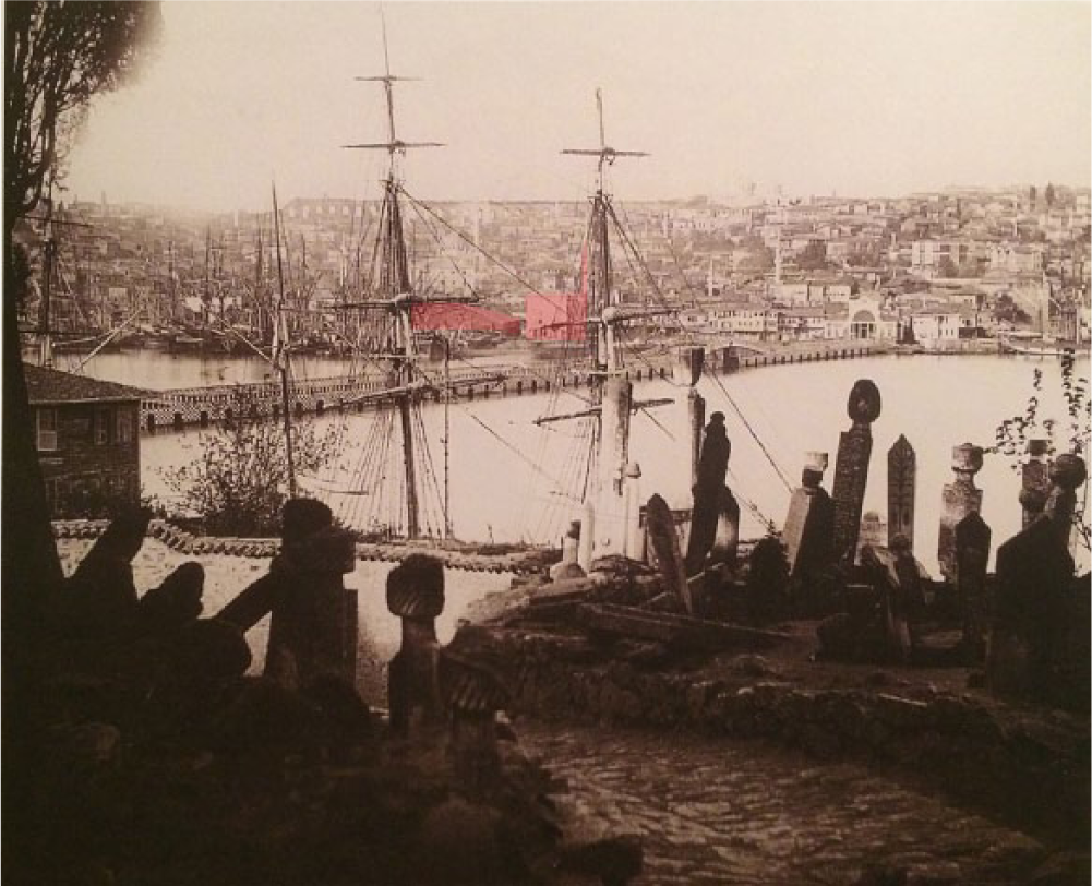
The photograph of the Unkapanı Bridge by Claude-Marie Ferrier, circa 1859.
After the construction of the Galata Bridge in 1845 at the entrance of the harbor, the one in Unkapanı was named the “Old Bridge” and would continue to serve as a passage of secondary importance, which would be replaced twice with new structures. Originally, it must have been used also for grain transportation in relation to the Arsenal granaries across the Golden Horn. The impact of the bridge on its landing just to the West of the former grain quay can be best visualized in the map of Stolpe from 1858 to 1863. 91 Here, a new urban square was formed dominated by a police station (kolluk) that was constructed in 1845. 92 This building was a novel landmark of order, being a two-story structure in imperial style with colonnaded projections facing the bridge and the Unkapanı Mosque (Figures 11 and 12).

Plan of the Unkapanı area between 1880 and 1915.
The act of fixing prices in Ottoman internal trade was abolished by the 1860s, which certainly brought an end to the traditional system of the grain wholesale market in Unkapanı. However, the waterfront square continued to function as a landing for grain, where former buildings were converted to new uses. Furthermore, the impact of the changes in the milling industry may be observed here. An imperial industrial mill factory, referred to as the Beylik Değirmen, had been initiated within the intramural sectors of Unkapanı by the late 1830s. 93 It was a state establishment farmed to private investors and was enlarged in successive decades as one of the largest industrial facilities in Istanbul. In fact, after the 1860s, the former Unkapanı Magazine was converted to a storehouse for this Imperial Mill Factory. This was the time when the depository of the grain wholesale market was literally turned into a granary. When, in the late nineteenth century, the maritime walls were partially dismantled, including the Unkapanı gate, 94 a new street was formed directed toward the Imperial Mill (Beylik street); narrow-gauge railroads from the harbor to the magazine and then to the factory were laid on this artery (Figure 12). 95 The new industrial line crossed over the former mechanism of grain provisioning while appropriating its buildings, such as the magazine and the council house.
The Unkapanı strand formed part of the new quays construction project on the Golden Horn issued after the 1870s; despite that, the section between the two bridges was not realized in the Ottoman era. 96 Nevertheless, some of the buildings on the smaller plots of the extramural zone formerly of wood were reconstructed as two- or three-story masonry shops and magazines. At the same time, the Unkapanı quays were partially refunctioned for the unloading of construction materials. The Unkapanı Mosque was reconstructed in the late nineteenth century on a similar footprint as the former structure when the three-story-high imperial kiosk was demolished. 97 The masonry building with a shallow hipped roof and a short minaret had magazines on the ground level, and there were symmetrical stairs on the western side reaching the prayer area on the second floor.
Photography became a new means of visualization for Istanbul after the mid-nineteenth century; 98 however, among the abundant visual sources produced with various photographic techniques, a clear view of Unkapanı can still barely be obtained, due to both the harbor’s occupation by ships and the congestion of small shops and loads of merchandise around the magazine and the mosque. Ironically, the only close-up photographs of the area are from the embankments toward the sea, and they usually picture the porters with their loads of grain, without showing an interest in framing the buildings that are the actual destinations of these workers. Nevertheless, the hipped roof of the Grain Magazine is still visible in panoramic photographs, where several roof windows can be observed (Figure 13). There is no visual evidence to claim that the same type of roof windows existed before the mid-nineteenth century, and they may have been opened into the roof recently along the model of those in the state granaries. 99 Oddly enough, the walls of the Unkapanı Magazine only became visible in the photographs of the 1920s and 1930s in the Republican period (as it had appeared in the ideal views of the sixteenth and seventeenth centuries) when the busyness of the quays lessened and the smaller structures around it were dismantled (Figure 14). The magazine shared the same fate and was demolished by the 1940s with the adjacent mosque. 100
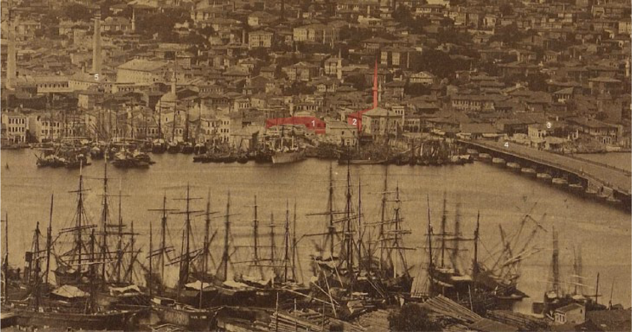
Unkapanı area in the panorama of Istanbul from the Galata Tower, circa 1875.
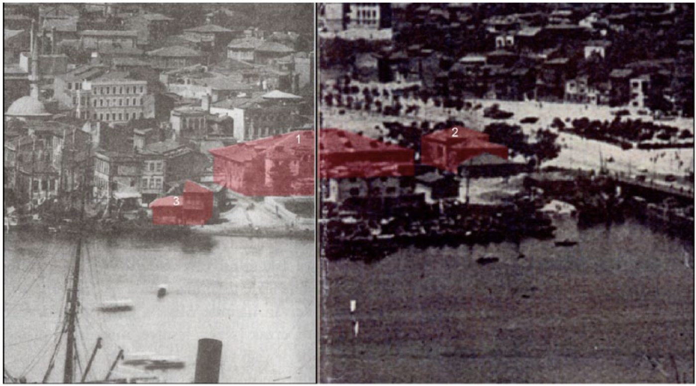
The former Unkapanı Magazine as a storehouse circa 1920 to 1940.
Because the survival of the Unkapanı Magazine and the Mosque up until the mid-twentieth century is recognized, the urban pattern of the landing square dating from the former periods can be discovered through the evidence of late Ottoman and early Republican maps (Figure 12). Moreover, these documents give information on the actual dimensions and position of the buildings. The Unkapanı Magazine was placed parallel to the city walls starting at a point near the Unkapanı Gate. The building had a roughly square plan (approximately 29.5 to 33 meters), wider toward the quayside. 101 It had a single entrance on the southeastern façade fronting an alley perpendicular to the shore (Unluk or Beylik Street). Rows of small shops were attached to its walls on the northeast side (by another Unluk Street) and toward the Unkapanı Mosque (by the Camialtı or Cami Arkası Street; literally meaning below or behind the mosque). 102 There were clerestory windows over the walls siding these shops. The façade facing the Ayazma Street by the fortifications was blank; this was the artery from the magazine to the Unkapanı Gate. The Unkapanı Mosque was built right in front of the city entrance as a gatekeeper dominating the traffic through this access. The length of the building, including the imperial prayer hall, was similar to the width of the magazine. However, the entrance of the mosque was not facing the magazine but was in the reverse direction. When it comes to the location of the Çardak-Dîvânhâne, this cannot be clearly identified. With the aforementioned evidence, the eastern point of the quay with an adjacent storage area, which is at the same inclination with the Unkapanı fountain, seems to be the most plausible option. 103 Could the open enclosure near this building be showing the replacement of the property toward the quay as it was extended in time into the Golden Horn? Last but not least are the clues for the internal structure of the Unkapanı Magazine: the insurance maps denote that the masonry magazine had two stories and that the upper floor was supported by French vaults—meaning low brick arches on steel beams, typical in the nineteenth century. The second floor carried by the French vaults can point to a restoration when Unkapanı Magazine was used as the storehouse of the Imperial Mill or the Ottoman Bank. In summary, it can be stated that more than the apparent association of the mosque and the magazine in the prospects, the urban tissue of the extramural landing square in plan displayed a complex pattern of streets and alleys providing alternative paths in between the landing stages and the city gate.
More than a Storehouse: Unkapanı Magazine as a Covered Khan
Unkapanı was the wholesale market of a city that was provisioned by grain imports supplied by the seaways. The contrast with an Ottoman export grain harbor can be observed at the location of Salonica’s (Thessaloniki) grain market, a city that was the hub of grain production in the Balkans. Salonica’s grain scale, also called Unkapanı, was near an urban square inside the fortified area at the crossing of two main streets, one of which led to the port, instead of being right next to the waterfront. 104 The stocks brought by land were controlled in this urban square and then transferred to the port. Meanwhile, Istanbul was peculiar in being an import harbor where the wholesale market was placed right at the waterfront as a customs square by itself.
The urban architecture of Unkapanı was clearly defined in the typology of a landing square with a magazine acting as a market hall, an office for the market inspector, and a mosque by the late sixteenth century, when it was reconstructed anew after a major fire under the supervision of Master Architect Sinan. In fact, during the period of Sinan’s intervention, the important kapans in other cities were generally constructed as khans with large enclosed courtyards. For example, a new grain scale in the city of Bursa was constructed in 1569, also attributed to Sinan, at a date very close to the rebuilding of Unkapanı in Istanbul: The Yeni Galle Khan, or Semiz Ali Pasha Khan. 105 On the eastern periphery of the market street of Bursa, this was a masonry market having two stories with a large, rectangular, enclosed courtyard, defined by regular arcades and cells on three sides and an irregular façade on the North. Another example is the Fruit Weighing Scale of Edirne, built in the late sixteenth century, in front of the closed shopping street of the celebrated Selimiye Mosque; it was a very large khan with a courtyard having magazines on the lower level and rooms behind arcades on the upper story 106 (Figure 15).
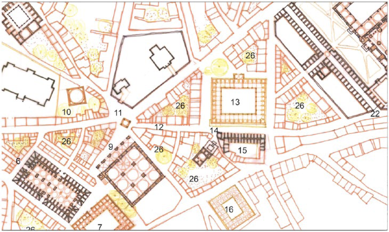
Hypothetical plan of the commercial center of Edirne around 1900.
The reasons why Istanbul was not embellished with a typologically similar building, a khan with a courtyard, during its reconstruction after the fire of the 1570s can be speculated as being due to the nature and the tradition of the maritime city front as well as the impact of the existing building traces. In fact, although there are khan-type buildings on the waterfront of other Ottoman port cities such as Izmir (Smyrna), no single, typical khan with a courtyard is to be found in Istanbul’s waterfront up until the nineteenth century.
However, there is another type of building that provides an architectural alternative to the khans with courtyards and a comparative case for the architecture of the grain magazine in Unkapanı: covered khans or caravanserai, being large basilica-like enclosures with gable roofs plated by lead. Generally labeled as leaded khan or caravanserai, this typology was mostly frequented in way station complexes. 107 Indeed, a precedent for a covered khan built on the waterfront can be mentioned in Istanbul as part of the Mihrümah Sultan Religious Complex on the Üsküdar landing stage by the Asian side of the Bosphorus erected under the supervision of Master Sinan. As far as the information in the original visual sources is concerned, on the maritime square dominated by the Mihrümah Mosque, there were two identical buildings symmetrically placed parallel to the sea as masonry elongated halls 108 (Figure 16). The one on the right of the mosque was the Kurşunlu Han or Caravanserai (Leaded Khan) whereas the one on the left was a storehouse. These two buildings had been destroyed by the 1930s; nevertheless, a surviving covered khan from the age of Sinan may provide evidence for the interior of this type of building: the Sultan Suleiman Caravanserai, also named Kurşunlu Han in Büyükçekmece (originally the last way station before Istanbul). Büyükçekmece khan is a masonry hall of twenty to fifty meters with an entrance on one of its short sides. In addition to the masonry walls, three rows of pillars—two rows by the sides and one in the center—form the interior structure where the roof rests on impressive wooden trusses projecting from these pillars (Figure 17). It is fair to argue that the Leaded Khan of Üsküdar was a similar edifice.
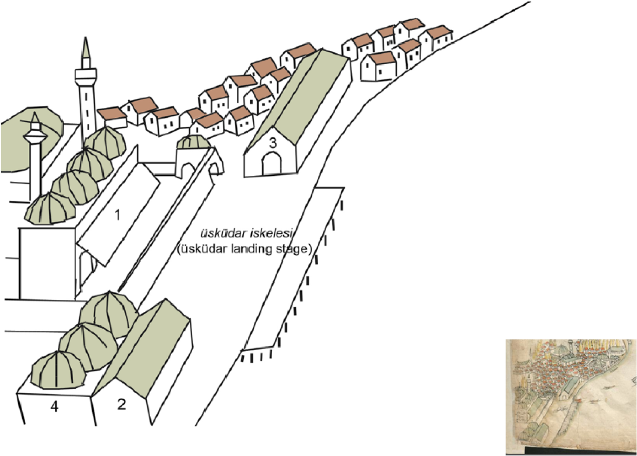
View of Üsküdar by mid-seventeenth century.
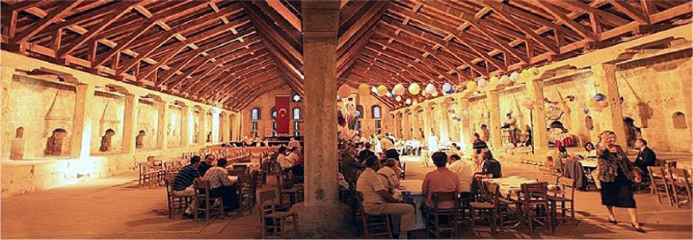
Photograph of the interior of the Leaded Caravanserai, Büyükçekmece, Istanbul, 2014.
The designation of the same architectural type for a covered khan and a storehouse in Üsküdar landing square is by itself meaningful in the representation of a shared genealogy. Indeed, such a typological relation would further be demonstrated when the Leaded Han of Üsküdar was found appropriate by the Grain Inspectorate to be converted into a grain storehouse in 1793. 109 At that point, separate grain bins in lanes were constructed, probably incorporating the interior structure. Consequently, there was a time when the Unkapanı Magazine and the Leaded Khan in Üsküdar had served a similar purpose in the grain provisioning of Istanbul. In reference to these examples originally built from the age of Architect Sinan, it may be here proposed that other than the magazines—such as the one in Eminönü, the Leaded Magazine, and Yağkapanı—the covered khans as halls with gable roofs may form a comparison for the architecture of the Unkapanı Magazine. In other words, the grain scale of Istanbul can, indeed, be interpreted as a variation of a covered khan. Then, it can be speculated that similarly, the interior of the Unkapanı Magazine had rows of wooden or stone pillars carrying large wooden trusses, which could have been replaced by a second story with French vaults in the late nineteenth century. The Unkapanı Magazine was more than a storehouse; it was a wholesale market hall acting at the same time as a depository.
Conclusion
The dimensions of the grain wholesale market of Istanbul, one of the largest cities of the Early Modern Period, as represented in this article may be surprisingly modest (Figure 8). The grain wharves, including the Tekirdağ landing stage, were no longer than 300 meters, and at its greatest amount of infill, the Unkapanı square on the extramural strand was no more than 150 meters in extent and width, including the buildings. The landings were several basic wooden embarkation platforms, while the embankments were barren earth consolidated by wooden planks and stones. The council house and the office of the grain superintendent was a wooden kiosk of several rooms raised over shops. The blueprint of the Unkapanı Mosque raised on magazines was approximately 400 m2. The shops and stores on the square were small units. The greatest edifice, the Grain Magazine that was both the market hall and a depository, was no larger than 900 m2. Given that this was the scale of the grain scale of Ottoman Istanbul, it should not be surprising to find many documents in the archives addressing the officials to speed up the procedures of the wholesale market to gain ground for the newly arriving merchandise.
The historians of the Ottoman economy who have focused on Istanbul’s grain provisioning specify the economic method for storing the grain reserves. While the state did store only up to 10 percent of the grain supplies, 90 percent of the grain imports were directly passed through Unkapanı and distributed to the city’s millers and bakers. 110 The bakers and millers were obliged to keep stocks to cover a minimum of six months, the quantity determined according to the scale of their establishment. This means that the majority of the grain reserves of the Ottoman capital would be spotted in the shops of small traders rather than in larger storehouses. 111 Unkapanı wholesale market constituted the bottleneck from the harbor to these stores.
Spiro Kostof had stated that renovating a working harbor is an impractical venture 112 ; the survival of Unkapanı from the fifteenth century into the twentieth is the example par excellence of this statement. Even within the period of Reforms, when most of the buildings in Istanbul were reshaped according to the Western models, there is no replacement for the historical Grain Magazine and the official weighing station similar to the nineteenth century market halls frequented in Europe. No building such as the great circular grain market hall of Paris called La Halle au Blé 113 is to be seen in the Ottoman capital. However, this conservatism in the wholesale trade and the buildings reserved for it has, ironically, become an advantage here in search of the present representation of an early modern wholesale market for grain.
Footnotes
Declaration of Conflicting Interests
The author declared no potential conflicts of interest with respect to the research, authorship, and/or publication of this article.
Funding
The author received no financial support for the research, authorship, and/or publication of this article.