
Abstract
Urban spaces and streets have been studied in a variety of ways in Montreal and Paris, but rarely have historians examined the specific relationship between the function of the street and social usage to reflect changes over time. The argument here is for an analytical approach to photographs combined with textual evidence to reveal the urban processes affecting the retail streets of rue Notre-Dame and rue Sainte-Catherine in Montreal, the through street of Boulevard de Sébastopol, and the pedestrian street of rue Mouffetard in Paris. Photographs reflect the success of modern urban transformations to rework the images of the city from various perspectives and for different purposes. They include the bourgeois female shopper on the late nineteenth-century retail and through streets, female retail and office workers interspersed among men on early twentieth-century rue Sainte-Catherine, and the agency of working-class women in the market transactions and peddler trades of rue Mouffetard.
Urban spaces and streets have been studied in a variety of ways in Montreal and Paris, 1 but rarely have historians examined the specific relationship between the function of the street and social usage to reflect changes over time. The argument here is for an analytical approach to photographs combined with textual evidence to reveal the urban processes affecting the street life of these cities in the late nineteenth and early twentieth centuries. Although the approaches varied, laissez-faire in the case of Montreal and municipal redesign in Paris, several factors shaped the function of the street, including changes in the modes of transportation, in the physical infrastructure of the street and sidewalks, in the built environment, and the advent of the department store. To examine the impact of these factors on social usage, the paper first examines the main commercial streets of rue Notre-Dame and rue Sainte-Catherine in Montreal with a retail function, the through street of Boulevard de Sébastopol created by Prefect of the Seine Georges-Eugène Haussmann as part of the first phase of street rebuilding on the central boulevards in Paris from 1853 to 1859 to improve circulation, and the pedestrian street of rue Mouffetard in Paris.
Henri Lefebvre provides a theoretical framework for understanding the urban redevelopment of these three types of streets and their respective roles in the changing cityscape in this period. Of particular relevance to the modernization of commercial streets in Montreal and Paris is his observation about how political power manipulates the production of social space to serve economic goals. 2 As a site of the circulation of capital, 3 the private ownership and activities of commercial streets are subject to a specific class and gender analysis. Renovations on the retail streets of rue Notre-Dame and rue Sainte-Catherine led to the construction of department stores. Pertinent to the redesign of the large thoroughfare of Boulevard de Sébastopol is his reflection that “[A] social space of this kind is generated out of a rationalized and theorized form serving as an instrument for the violation of an existing space.” 4 However, the more pre-industrial pedestrian streets like rue Mouffetard remained.
The social dynamics represented in the imagery of streets like rue Mouffetard are an important contrast to the photographs of social usage on retail and through streets. Walter Benjamin’s reasoning in this regard is that street photography entered a new stage at the turn of the century, especially with Eugène Atget. Photographs of streets established evidence. In Benjamin’s words, “[W]ith Atget, photographs become standard evidence for historical occurrences, and acquire a hidden political significance. They demand a specific kind of approach; free-floating contemplation is not appropriate to them. They stir the viewer; he [sic] feels challenged by them in a new way.” 5 Benjamin’s observations are accurate insofar as the selected photographs of rue Mouffetard provide historical evidence of social interaction at street level, and thus lend themselves more easily to a class and gender analysis than many of the photographs of the retail streets and the through street presented in this paper. Photographs of the pedestrian street are close up, highlighting the congestion and confined traffic in the old city.
The central aim of many of the photographs of the retail streets and the through street is to reinforce the economic goals of private retail development and municipal redesign. Many images of rue Notre-Dame and rue Sainte-Catherine thus encourage and reflect consumption and work. Photographs of Boulevard de Sébastopol reveal the efficiency of the urban thoroughfare for traffic circulation and for pedestrians. For this reason, the images are often taken from a bird’s eye view and from far away, magnifying the openness created by the redevelopment of the city. In providing a specific perspective to justify the modernization, the images play a decisive role in reproducing space in particular ways and in reworking the city as a whole.
To illustrate the visual conception of the urban environment, I have chosen sixteen selected photographs of collective street scenes mainly from the archives of the Bibliothèque et Archives nationales du Québec à Montréal Massicotte, the Bibliothèque nationale de France, the Archives de la Ville de Montréal (AVM) Institutional Affairs collections, the AVM Les grandes rues de Montréal website, published photographic collections, and from monographs. The analysis is attentive to the purpose of each image and the extent to which the collection and the street photographer shape the perspective and the content.
A photo-analytical method demonstrates how establishing the context of the historical photograph can nuance an understanding of urban processes from the perspective of the street. This method draws from the visual theory of Benjamin and the Marxist critique of the capitalistic mode of production. 6 The photographs are viewed as visual representations shaped by the photographer, the archival collection, and the historian. The paper points to the purpose of each photograph in shaping its form, content, and interpretation to discern various patterns in Montreal and Parisian street life. The approach draws from the practices of some social urban historians who treat photographs and other visual representations as crucial pieces of historical documentation on par with written sources. 7 Current theoretical tendencies and intellectual orientations may have broadened the spectrum of primary sources, yet urban and social historians more often use photographs, sketches, and maps to illustrate or supplement histories of modern cities. 8 This disciplinary inclination stands in contrast to art and architectural historical practices using visual representations as central forms of evidence. 9 It is important to note that the analysis of visuals is gaining prominence in the historical academy. 10
The argument is that in the treatment of a documentary photograph, the historian attempts to reduce the gap between the object that records and supplies information and the interpretation of the popular representation of the photographic image as subject. The subjective elements are dependent on several factors, including the genre, the photographer’s selection or choice, the technical apparatus and reproduction, and the archival collection. Subject to analysis are the contents of the photograph and the factors instrumental to its representation.
The historian can then recognize the merits and limitations of treating a photograph as a social document where the context is subject to an analysis that requires words. In his analysis of a photograph of a second-grade public school student in Buenos Aires, Argentina, for instance, Gustavo E. Fischman has observed that the photograph is not merely an illustration, as when “placed in its historical context the details of this picture acquire a different significance.” His argument is that “. . . it should be noted that if a picture is worth a thousand words, in order to understand it, reflect on it, or explain it, we might need to use a thousand and one words. And, even then, there is nothing transparent or inherently truthful in the world of images.” 11 The cultural reading of the photographs strives to bridge the gap between the objective treatment of the construction of the photograph and the subjective cultural representation. In his critical reading of visual imagery, Martin Kemp has suggested that the parameters of reference governing the initial making of the photograph shape its function, context, and meaning. More difficult to discern are the subtle cultural readings of visual imagery, the more “varied associations for very large numbers of people across time and cultures.” 12
The Retail Street
The analysis begins with the retail function of rue Notre-Dame and the shift to rue Sainte-Catherine as the main commercial street of Montreal in the late nineteenth and early twentieth centuries. The introduction of new modes of transportation instigated changes in the physical infrastructure of these streets that led to retail development. The widening of rue Notre-Dame to 9.7 m (30 feet) for the horse-drawn omnibus took place from 1864 to 1868, to 13.4 m (44 feet) in the central portion, and rue Sainte-Catherine had a width of 16.76 m (50 feet) by the 1850s and 1860s. Both street widths accommodated the introduction of the electrical tramway in 1892 and the automobile in the interwar period. The widening of rue Notre-Dame facilitated the construction of large wholesale and retail establishments, and by the 1870s, the department store. Beginning in the 1880s and 1890s, many of these department stores moved from Old Montreal to rue Sainte-Catherine. The retail function of rue Sainte-Catherine was critical to the development of an uptown urban core in this period, yet Old Montreal still retained major banking and financial institutions. With the establishment of some bank branches, insurance company and big business head offices on and around rue Sainte-Catherine in the first decades of the twentieth century, the mixed-use function of the street was achieved, and it attained main street status.
Rue Notre-Dame developed as the main retail street of Old Montreal, the center of the city since its inception. By the nineteenth century, Old Montreal was not only the site of the port, important churches, and religious institutions, but also the Customs House, banks, and the homes of the bourgeoisie. The demolition of the walls executed as part of the Commissioners Plan by Roads Inspectors Louis Charland and Jacques Viger from 1804 to 1820 allowed for the extension of rue Notre-Dame to Faubourg de Québec or Sainte-Marie in the east and other streets, such as rue Saint-Laurent, to the northern faubourgs. Rue McGill remained the western periphery of this urban core, and there was little development north of rue Sherbrooke. 13
In the mid- to late nineteenth century, from 1850 to 1880, the retail function of rue Notre-Dame evolved (along with that of rue Saint-Paul, rue McGill, and rue Saint-Jacques) to serve the bourgeois market. Because the domestic cult of Victorian society encouraged consumption of the latest fashions from London and Paris, Montrealers in general, and especially the urban bourgeoisie, purchased local and imported goods available in these shops on rue Notre-Dame and on rue Saint-Jacques. The widening of rue Notre-Dame from 1864 to 1868 for the horse-drawn omnibus led to demolition on the north and south sides of the street, and the construction of more elaborate stores, with many stories and large windows. Initially wholesale and retail establishments operated together, then the stores became solely retail, and by the 1870s, there were department stores with specialized sections. This followed the arrival of larger stores such as Bon Marché in Paris, Bainbridge and Lewis in England, Stewart and Macy in New York, and Marshall Field in Chicago. Montreal department stores began offering a broader range of products to increase consumer demand, and businessmen were responsive to the market forces. For instance, Henry Morgan, who was established in Montreal since 1843-1844, set up his first store on rue Notre-Dame in 1855, then moved it to rue Saint-Jacques in 1865, and adopted a departmental system by 1878. The department store on rue Notre-Dame in Figure 1 is most likely Carsley’s that had opened in 1871 and became the largest of its kind in this period. 14
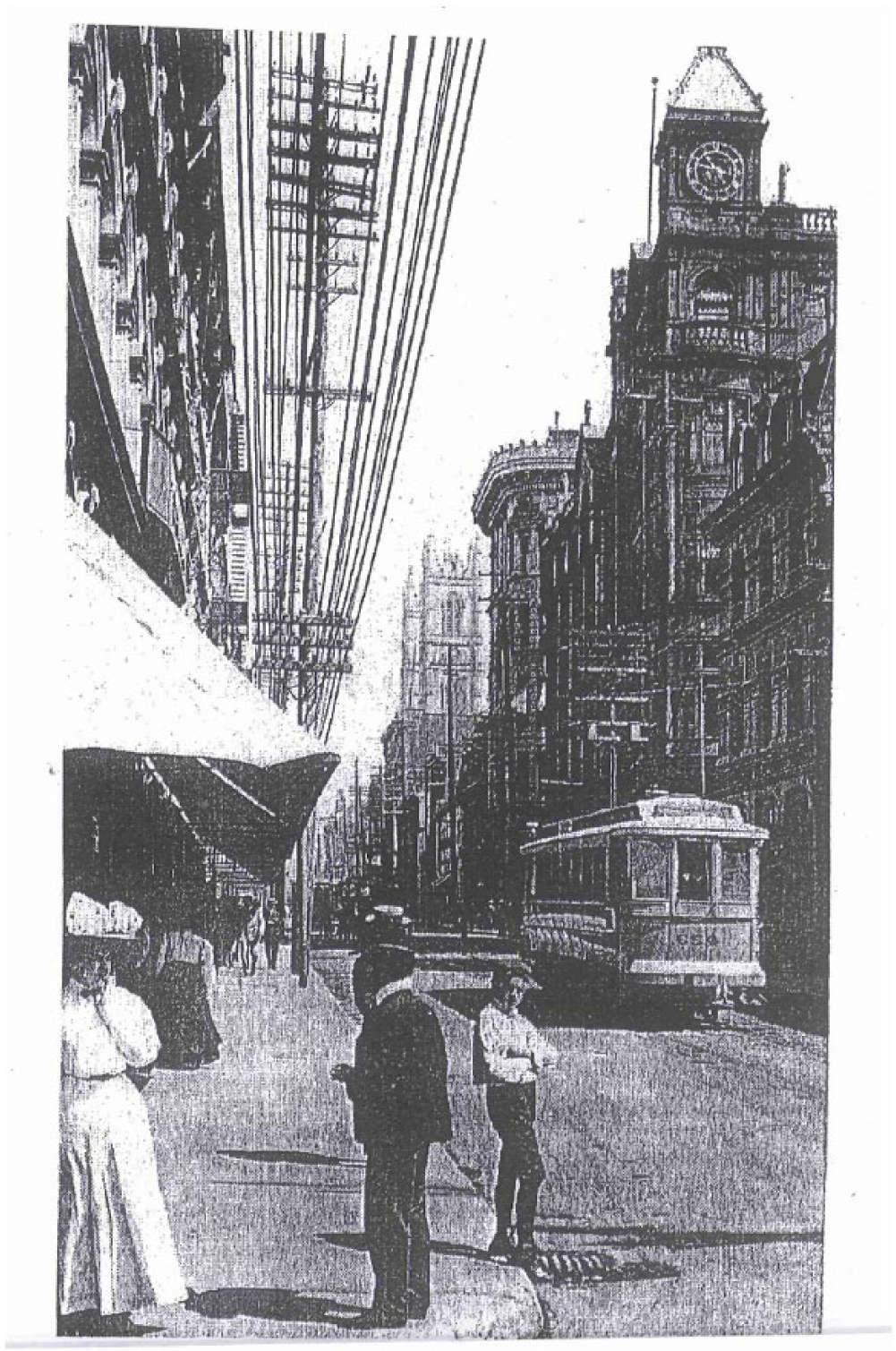
Rue Notre-Dame, 1907.
The content of the photograph brings together the influences of transportation, physical infrastructure, and the built environment with social usage. One notes the interaction of people on a main street in a busy downtown core, concrete sidewalks, a paved street surface, a jumble of overhead electrical wires, and a streetcar in active operation. The architecture consists of elaborate stone structures of three, four, and five stories, and the store with an awning on the left. This photograph displays not only the introduction of the new tramway technology and the continued use of horse-drawn carriages more difficult to discern in the background, but also a dense streetscape and a varied street life.
In the foreground is a young boy on the curbside, as well as a woman in a ribboned hat conversing with a man in a bowler hat on the sidewalk. There are also a few clusters of people in active conversation, and people strolling on the street in movement to businesses and stores. Also relevant is the gendered sociability with women more clearly situated near the store entrance. This sweeping street scene demonstrates a blurring of public and private boundaries, with women drawn to the segmented sections of the store windows. The bourgeois clientele, the conviviality associated with consumption, and the class harmony are conducive to the intent of this 1907 postcard taken by the Studio Neurdein in Paris to draw tourists to the city.
Meanwhile, as the demolition of the walls in Old Montreal from 1804 to 1820 made possible the eastern extension of rue Notre-Dame, it also led to a population increase in the northern faubourgs and further development in the east-west trajectory of rue Sainte-Catherine. The accompanying map shows that by the early twentieth century, the main commercial streets of Montreal run in a relatively east-west direction: rue Notre-Dame, rue Sainte-Catherine, and rue Sherbrooke, followed by the secondary commercial and residential streets of rue Saint-Laurent, rue Saint-Denis, and rue Saint-Hubert traversing the city from north to south (Figure 2). Rue Sherbrooke had a unique character, moving from a residential and pastoral quality to a street of promenade by the late nineteenth century, planned to emulate Fifth Avenue in New York and the Champs d’Élysées in Paris, prestigious avenues and green boulevards. 15
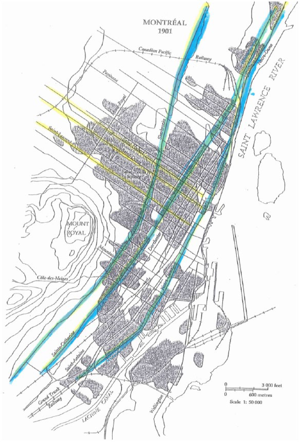
Commercial streets of Montreal, 1901.
The through streets traversing Montreal in a north-south direction, rue Saint-Laurent, rue Saint-Denis, and rue Saint-Hubert, were also sites of retail and business establishments in this period. Rue Saint-Laurent was the most commercialized at this time, especially in its proximity to rue Notre-Dame and rue Sainte-Catherine. 16 Rue Saint-Denis was a mixed-use street for residential and business purposes, and rue Saint-Hubert was home to many of the francophone bourgeoisie and petite bourgeoisie. 17 These streets were vital transportation links from the old-walled city to the urban periphery and provided services for people in the nearby quartiers.
The retail function of rue Sainte-Catherine was established in the 1860s as the site of small businesses, especially grocery stores for residents in the adjoining quartiers of Sainte-Marie, Saint-Jacques, and Saint-Louis in the east. Nazaire Dupuis and Charles Desjardins were notable merchants there. The densest commercialization was at the corner of rue Saint-Laurent in Faubourg Saint-Laurent. Saint-Antoine in the west was mostly residential at this point. Rue Sainte-Catherine penetrated Hochelaga and Maisonneuve in the east by 1870 and 1883 and Côte Saint-Antoine and Westmount in the west by 1879 and 1895. The entire street attained a width of 16.76 m (50 feet) by the 1850s and 1860s and a length of 11.2 km (7 miles) by the 1950s. 18
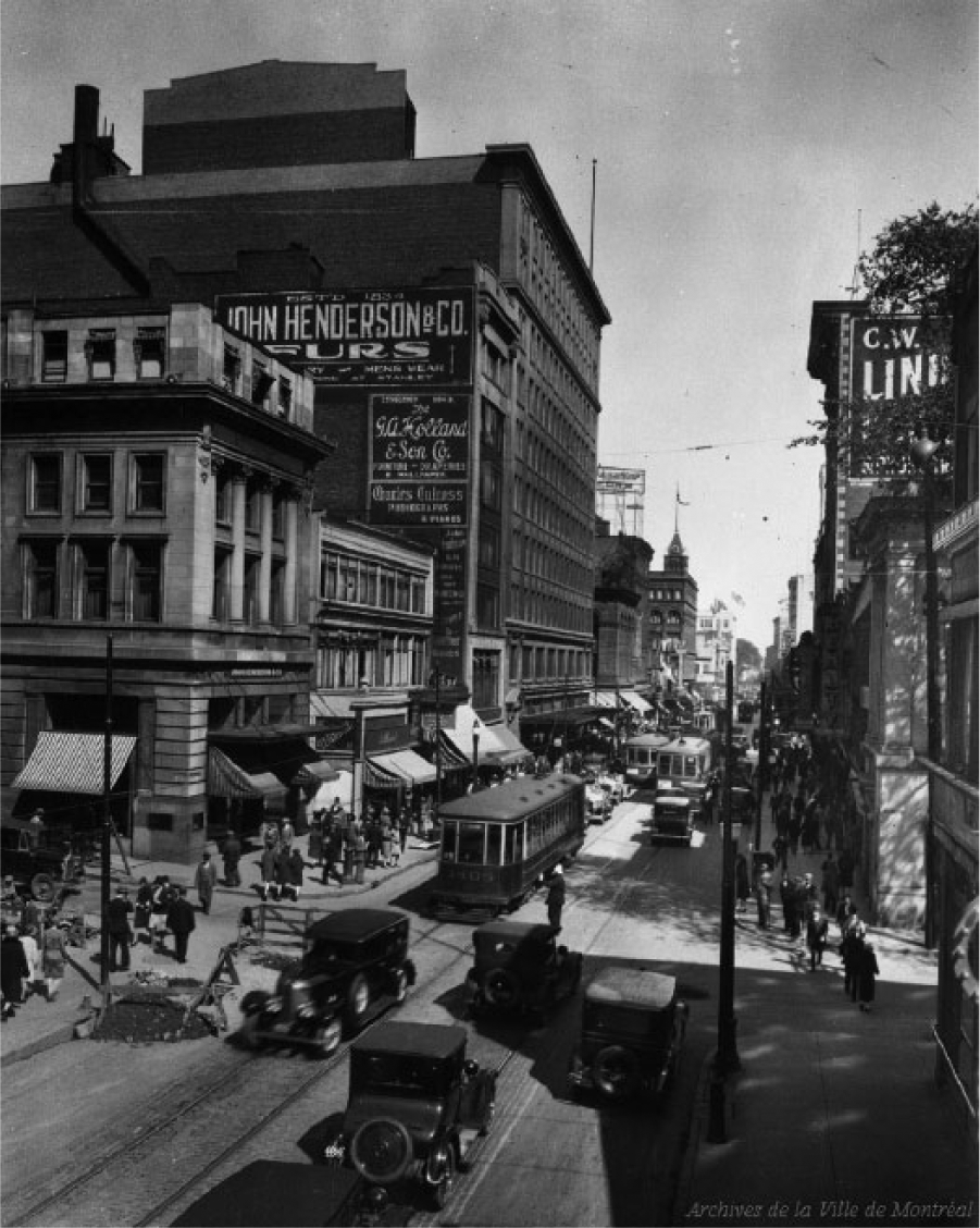
This growing market led businessmen like Morgan to move his department store from Old Montreal to establish a much larger one on rue Sainte-Catherine in 1891 (Figure 3). 19 The photograph of Morgan’s department store on rue Sainte-Catherine at Phillips Square in 1936 contrasts with the 1907 photograph near Carsley’s on rue Notre-Dame. Whereas the perspective of the postcard at street level emphasizes the social usage, with people situated near the store entrance, and others in motion, here the dominant focus is on the imposing four-storey building with Phillips Square in the foreground. Because the photograph is taken from farther away, one can less clearly discern women and men in conversation near and opposite the store entrance, two women seemingly moving toward it, and several people walking to other destinations. Part of the Archives de la Ville de Montréal Institutional Affairs Collection, this photograph reflects the consumerist ethic of the 1930s and Morgan’s as a focal point in the urban culture of the modernizing city.
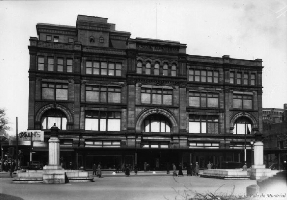
Morgan’s, rue Sainte-Catherine, 1936.
As in the more upper-class space of rue Notre-Dame and its department stores, Morgan’s attracted an affluent female clientele because of “its haute couture status.” Donica Belisle has observed that “[N]on-affluent people considered it snobby and working-class francophones avoided it altogether.” 20 Many of the customers were bourgeois women and an increasing number of single, married, and widowed women worked in retail in this period. 21
Many of the men on the street may have been employed with other retailers who joined Morgan on rue Sainte-Catherine in the late nineteenth and early twentieth centuries. The Birks jewelry store situated opposite Morgan’s and across from Phillips Square was the largest of its kind in Montreal. Established on rue Saint-Jacques in 1879, it moved to rue Sainte-Catherine in 1894 and expanded in 1907. Similarly, in 1897 James A. Ogilvy changed his store location of thirty years in Old Montreal to rue Sainte-Catherine. Nazaire Dupuis, then his brothers, had expanded their operation and imported many French goods for the Dupuis department store on rue Sainte-Catherine in 1882. Other dry goods stores and two major department stores were installed on the street by Toronto retailers Robert Simpson in 1905 and Timothy Eaton in 1929. Rue Sainte-Catherine was thus gaining prominence over rue Notre-Dame, and more female and male customers and employees at these stores traversed the street. 22
The private initiatives of retailers to serve a larger market began a northward shift in the Central Business District from Old Montreal to rue Sainte-Catherine. A 1928 photograph from the Archives de la Ville de Montréal Institutional Affairs Collection points to the consequences for rue Notre-Dame and the diminishing relevance of stores and the proliferation of offices and businesses there by the early twentieth century (Figure 4). The men standing on the sidewalk appear to be taking a break from work, there are no women or men visibly engaged in purchases, and the streetscape is dominated by automobiles with an electric tramway retreating in the distance. The absence of women is explained by the fact that Old Montreal remained an important site for finance, business, newspapers, and law firms in the early twentieth century with the retreat of major stores. The photograph documents the principal business function of the street.
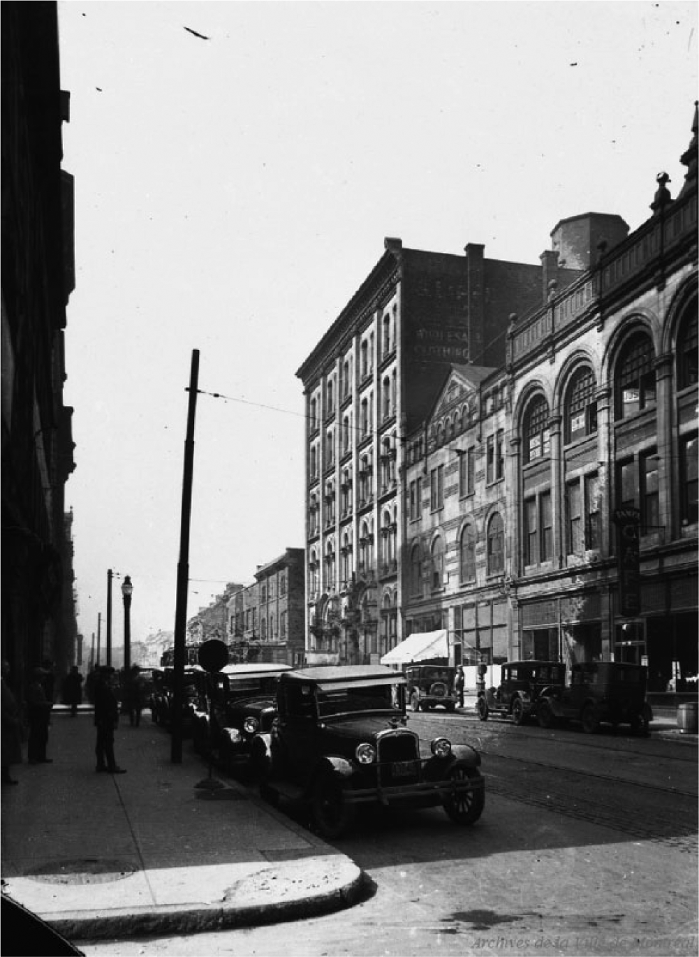
Rue Notre-Dame, 1928.
A financial district developed on Place d’Armes and rue Saint-Jacques with the arrival of several life insurance companies and banks. Among these financial institutions were the Molson’s Bank (1864-1866), the New York Life Insurance Company (1889), the Banque du Peuple (1893-1894), later the Banque d’Hochelaga, and the Banque Provinciale (1900), the Bank of Montreal (1885-1886, 1901), the Canada Life Assurance Company (1894-1895), the Montreal Board of Trade and the Montreal Stock Market (1903-1904), and the Royal Trust (1912-1913). The printing and offices of the newspapers The Montreal Star, The Gazette, and La Presse were located near Place d’Armes. 23
The concentration of finance in Old Montreal was accompanied by a gradual shift of business and some financial institutions on and around rue Sainte-Catherine in the years leading up to World War I, and from the 1920s to the post-World War II period. Several banks such as the Bank of Montreal (1889) and the Molson’s Bank (1900) set up branches on this street, and in 1913, the Sun Life Insurance Company left Old Montreal where it had been established since 1871, to construct a head office on Dominion Square to the south of rue Sainte-Catherine. The newspaper La Patrie also left rue Saint-Jacques for rue Sainte-Catherine in 1905, and in 1922 Canada Cement constructed a building on Phillips Square. 24
I employ two photographs of rue Sainte-Catherine, the first taken in 1898 and the second in 1928 to reflect changes over time, to identify a different purpose, and a varying class and gender composition (Figures 5 and 6). The likely promotional context of the first photograph from the Archives de la Ville de Montréal Institutional Affairs Collection portrays a well-ordered, well-managed, and spacious tree-lined commercial street open to further development. The central perspective is on the street surface, the tracks, and the 50-foot width to accommodate the electrical tramway approaching in the distance. The use of carts and bicycles continued alongside this new technology. Small, medium, and large stores flank both the north and south sides of the street, and there are several pedestrians with two women situated near a store window.
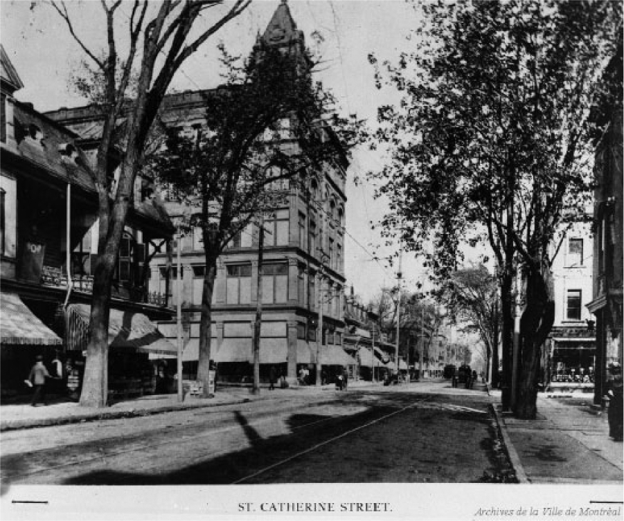
Rue Sainte-Catherine, 1898.
Rue Sainte-Catherine, 1928.
The vibrancy of the mixed-use street is more apparent in the 1928 photograph taken at the corner of rue Stanley, one of the busiest intersections on the western portion of rue Sainte-Catherine. Whereas the first photograph presents an image of respectability to entice commerce, this photograph celebrates the success of the street as one of “Les grandes rues de Montréal.” There is a clear definition of lanes, the compatibility of the electric tramway with the automobiles amid the street repair, and a policeman patrolling the traffic. A blend of male and female pedestrians is situated near the shops and offices, and the commercial buildings of three, four, and six stories on the north side. The people are walking in seeming anonymity with the exception of a conversation among several men on the south side. The overall atmosphere is one of traffic congestion necessitating regulation, commercial advertising, and an active street life.
The employment of women as stenographers, typists, secretaries, and clerks in business offices, in addition to retail, explains the visibility of more women and the preponderance of men on the early twentieth-century commercial street. Males occupied the upper clerical and supervisory ranks and women were hired “to the bottom of the administrative hierarchy.” Graham S. Lowe has noted that “[F]or example, Sun Life Insurance Company of Montreal hired its first female clerk in 1894; by 1914 many departments had ‘an army of typewriters,’ and there was a central typing pool with dictating machines—all operated by women.” 25
Transportation facilitated the access of people to stores and offices and enhanced the success of rue Sainte-Catherine as it became an axis of communication traversing Montreal from east to west, and one of the first Montreal streets serviced by the electric tramway between rue du Havre and avenue Atwater where most of the stores and offices were located. Introduced in 1892, electrification supplanted the horse-drawn omnibus. The entire system had 11 million passengers in 1892 and 107 million by 1914. The introduction of automobiles in the interwar period added to the traffic and congestion on the main street. There were only five hundred automobiles in Montreal in 1910, and that number increased to fifty-five thousand by 1928. 26 In a laissez-faire approach to urban development, the concentration of retail, business, and finance on a major artery fixed rue Sainte-Catherine as the main commercial street of Montreal by the early twentieth century. The evolution of the retail street was reinforced by a width amenable for public transportation and for the circulation of automobiles leading to a street life conducive to work and consumption.
The Through Street
A public transportation system and the accompanying transformations increased the value of the retail street in the Montreal urban core. Whereas transportation and infrastructure were instrumental to central urban street development, the primary motive of the through street is for transportation. By definition, it is an urban thoroughfare for travel between two points. In the case of Haussmann’s municipal redesign of Paris, the construction of broad thirty-meter-wide (98.4 feet) boulevards involved extensive modifications in street infrastructure to improve circulation.
I employ Boulevard de Sébastopol as an example of an urban thoroughfare “designed to open up the center of the city” 27 as part of the north-south axis of the grande croisée. Its 1.3 km (.807783 mile) length extended to Boulevard Saint-Michel in the south, and joined the east-west axis of rue de Rivoli with the Gare de l’Est. This was the first phase of street rebuilding on the central boulevards from 1853 to 1859 conducted as part of the redesign of the city by Haussmann. Reconstruction moved to the second phase on the exterior boulevards from 1859 to 1867, followed by the extension of the interior boulevards from 1869 to 1870. The concentration of bourgeois capital was at the city core and the symbolic center of Paris was at l’Arc de Triomphe and the Champs-Élysées (Figure 7). 28
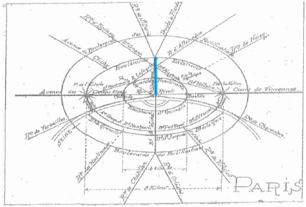
Diagram of Paris urban street system by Eugéne Hénard, undated.
The through street eased travel, either by walking or using public transportation and later, the automobile, to retail streets in the urban core. Yet, this did not preclude the function of the through street as a secondary commercial street, the site of stores and offices. Images of Boulevard de Sébastopol convey the nature of urban redevelopment at this time, with the construction of the rational thoroughfare for traffic and pedestrians. An 1860 photograph from Roger Viollet’s collection The Image Works is taken from a broad perspective and from far away to denote the openness of the city (Figure 8). Characterized by the uniform design of recent reconstruction completed in 1858, there is a continuance of horse-drawn carriages for passengers and supplies, a clear definition of lanes in the two-way traffic, some orderly pedestrian crossings at the intersection in the background, and people mostly walking to work likely in the morning on the wide recently tree-lined sidewalks. The built environment is prominent and symmetric. The stone structures of six stories with shops on the ground floor suggest the possibility of people consuming, yet there is little evidence of entry into the stores or of people conversing. This photograph conveys the overall purpose of the boulevard for traffic of people and goods to other parts of the city.
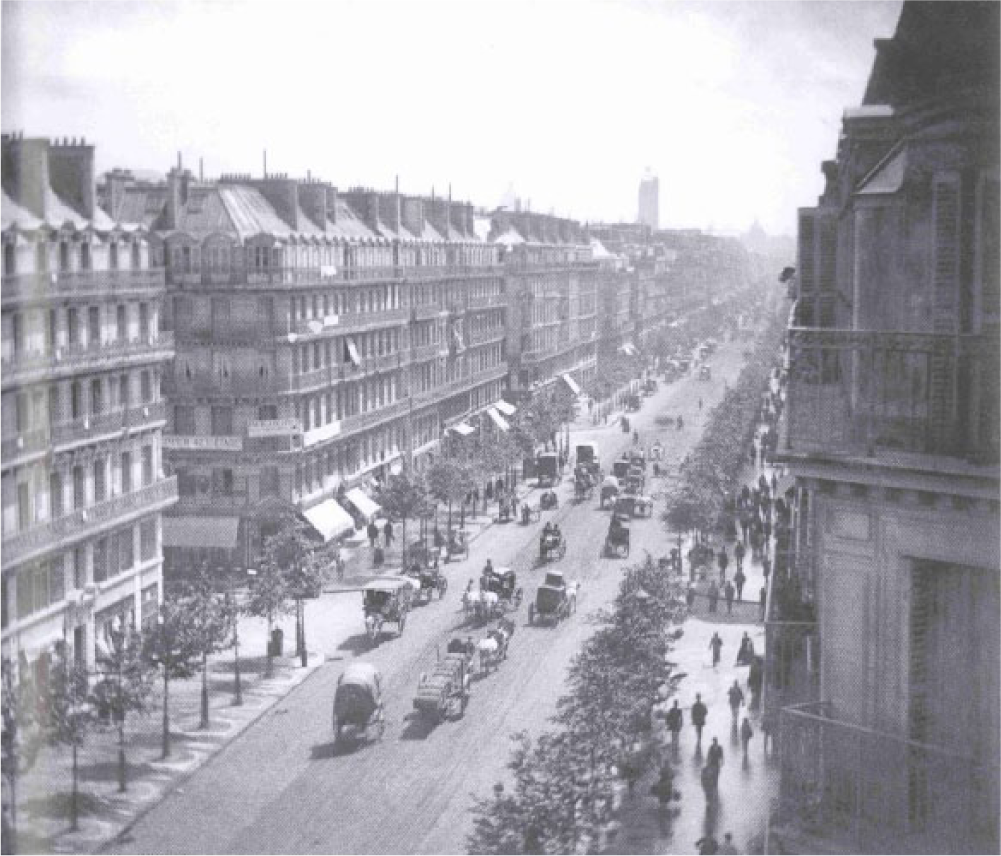
Boulevard de Sébastopol, 1860.
The particularities of the pedestrians are difficult to discern, yet the majority are men with one woman carrying purchases and some females strolling in the foreground. One could infer that most of these people are bourgeois given “the overturning of neighborhoods full of working-class homes, stores, and workshops for . . . the boulevard de Sébastopol.”
29
The photograph reworks the city and the boulevard as a dominantly male bourgeois space, and captures the vista Haussmann sought to create. Shelley Rice has observed that [H]is boulevards, therefore, were conceived as Parisian views; his shaping of the visual space of the urban environment was goal and object oriented. The trees lining the boulevards, the uniform buildings that faced the streets, and the straight lines of the roads themselves; all of these were designed to enhance the vistas so central to Haussmann’s planning of Paris, . . . The aesthetic order that Haussmann imposed on his capital, therefore, could only be grasped on a map, or by a visual overview (which makes panoramic and aerial photographs particularly relevant to this period). In his systematic planning of the city, in his insistence on a scale and range beyond human sense perceptions, Haussmann began, therefore, in spite of his fetish for monuments and vistas, to destroy the primacy of objects. In his Paris, the street—the means of transport, the channel of relationship between objects—becomes dominant.
30
Two further images, the first an undated postcard, and the second from the Bibliothèque nationale de France photographic collection of urban culture, offer a closer view of street activities (Figures 9 and 10). The postcard emphasizes the vitality of the street, public transportation, and consumption for tourists. There is varied vehicle and pedestrian traffic and a degree of spontaneity in the ease with which both males and females crossed the street and negotiated the traffic at a busy intersection, and compatibility between the horse-drawn carriages, carts, and the electrical tramways in both lanes. This points to the success of the mass transportation and infrastructure made possible by Haussmann’s renovations. 31 Most of the pedestrians are men, either gathered in groups or walking alone, and one woman is leaving a corner shop with a purchase in hand. Although the purpose and perspective differ from the vista, both images rework the city as a site of circulation for working and shopping, mostly dominated by men.
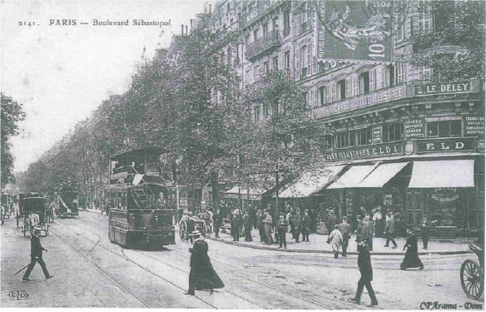
Boulevard de Sébastopol, undated.
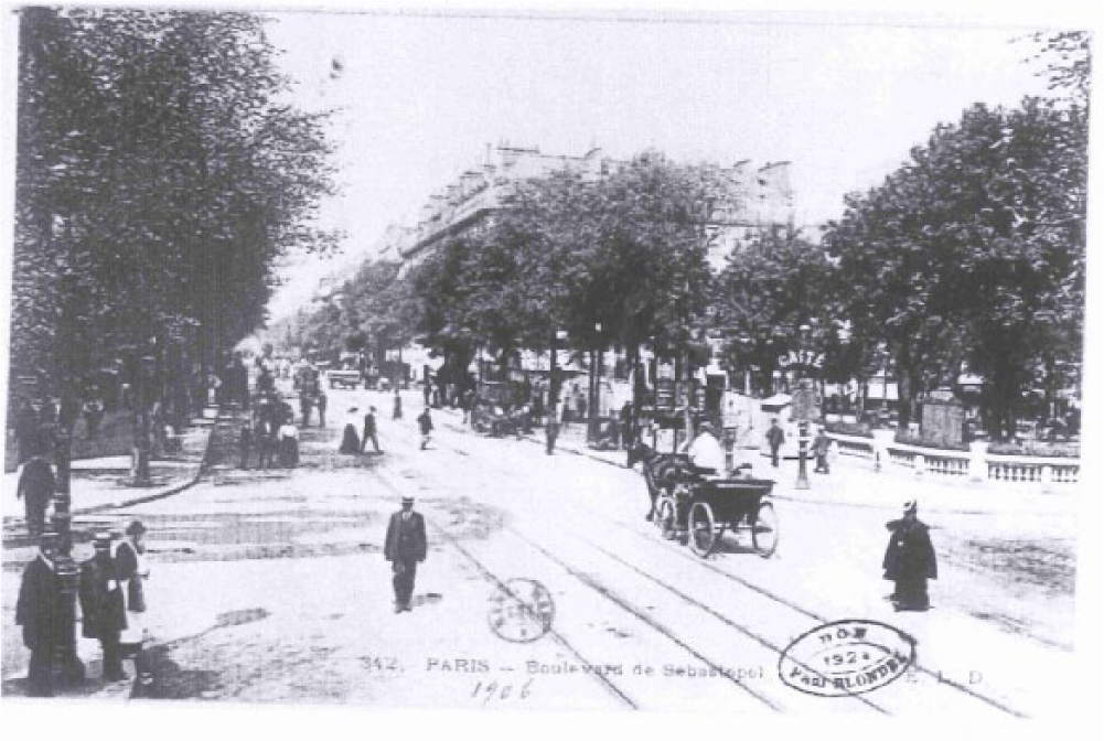
Boulevard de Sébastopol, 1906.
The 1906 photograph reflects the success of the broad thirty-meter-wide (98.4 feet) interior boulevard as a symbol of modern Paris and as a focal point of street life after Haussmann. Possibly taken on a Sunday, the focus is on the street itself to reflect its width and the leisurely stroll of pedestrians, some who linger on a street corner, and others who cross it freely. Prominence is given to the park on the right and the mature trees. As in the two previous photographs, most of the people are in bourgeois attire, though here there are more women.
The means of transport was a central factor in the construction of the interior boulevard that facilitated motor traffic as horse-drawn vehicles gave way to the automobile in the early twentieth century. Because the Second Empire considered insurrection on the streets as a threat to political stability, Napoleon III instructed Haussmann to instill more pragmatic symmetry in Paris on the major arteries of the Right Bank. The principal goal was to transform the narrow streets and lanes of the inner city, the sites of political resistance in the revolutions of 1830 and 1848. 32 The aim was to stymy the infinite possibilities of people engaging in political resistance and disorderly conduct on the streets. Marcel Cornu has expressed the overall consequences of these changes for public social life in an articulate and lyrical manner: “. . . finie la commedia dell’arte qui se jouait dans les rues. . . .” 33
Haussmann’s redesign of Paris raises several controversies among historians, principally this question of the annihilation of existing street space, the displacement of the working class, and the military incentives. The new layout and the destruction of homes on the narrow city streets led to property expropriations occurring first in the inner arrondissements of the Right Bank. These expropriations forced many working-class families who lived there to relocate in the urban peripheries and the suburbs, mostly in the eastern and northeastern portions of the city. This relocation was followed by a rise in rents in the inner city. In 1852, the city modified the municipal statutes to pass an expropriation law that gave Haussmann the liberty to exercise extensive powers. With the cost of expropriation set at 15 to 20 francs per square meter, the reconstruction engendered several monetary crises. 34
In an undated photograph, Charles Marville captures the poignancy of the destruction for a boy seated among the ruins of former homes (Figure 11). Taken at the corner of rue de Rivoli, his photograph of Boulevard de Sébastopol prior to the reconstruction is somewhat desolate and focuses on a commercial building at a time when there were no people, and an absence of activity (Figure 12). One could infer that he was capturing the commercial function of the street and not the social usage to rationalize the impending reconstruction. Colin Westerbeck and Joel Meyerowitz have observed that because Marville was the official state photographer, and “since this photographic record was being kept to justify tearing down most of the subjects, it was not to Marville’s advantage to have them look conventionally picturesque.” 35
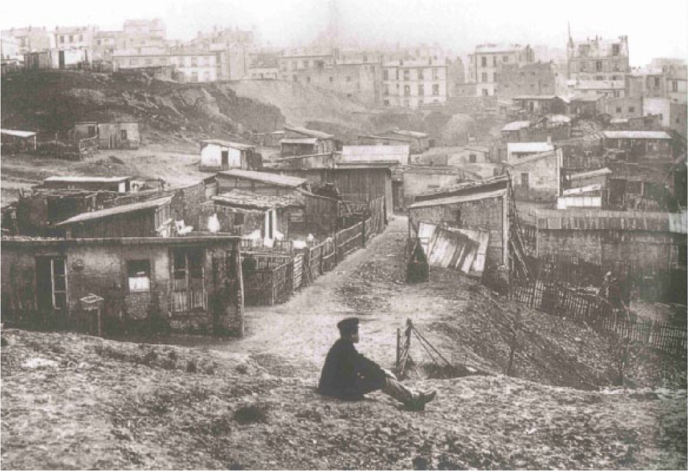
Working-class displacement.
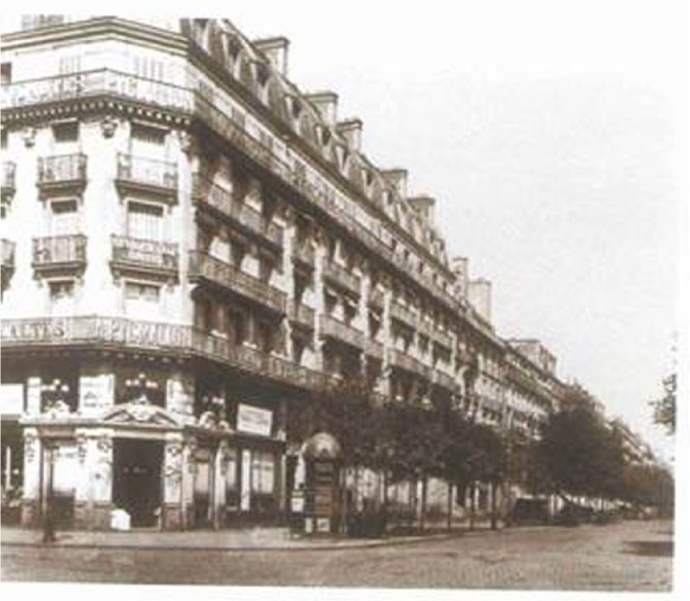
Boulevard de Sébastopol, undated.
This visual evidence is an indication of a broader disagreement among historians, principally between Patrice de Moncan and Hervé Maneglier, as to whether Haussmann could be held responsible for the relocation of working-class families and the increase of rents in the inner city. In citing a survey taken in 1865, de Moncan claims that there was not a significant decrease in Paris housing occupied by low-income Parisians and that the poor were not driven out of Paris because of Haussmann’s reconstruction. He maintains that a spatial segregation between rich and poor was occurring before Haussmann, a point observed by Michel Carmona. Maneglier, however, argues that an increase in rents and more demand for housing forced many tenants to the outer neighborhoods with lower rents. 36
There appears to be a consensus among historians that Haussmann’s urban redesign took on three basic aims: to improve circulation and hygiene, and to achieve more paix sociale, roughly translated as “social peace” or public order. The methods employed to fulfill these goals were subject to discussion among critics of public and social space on the Right and on the Left, particularly as regards the military incentives instrumental to his street plans. The argument is that the cavalry could more easily negotiate the straight-line boulevards created on the Right Bank, yet de Moncan argues that the primary motive in many cases was hygiene. 37 Lefebvre’s view contradicts that of de Moncan. He claims that if Haussmann “perce des boulevards, s’il aménage des espaces vides, ce n’est pas pour la beauté des perspectives. C’est pour ‘peigner Paris avec les mitrailleuses.’” 38 Cornu also observes that Haussmann purposely installed the military infrastructure near the homes of “les classes dangereuses.” 39 Jacques Rougerie interprets the resistance of the Paris Commune in 1871 as isolated events not related to the new boulevards. The Communards placed paving stones such as the ones in Figure 13 on Place de la Concorde at the intersection of rue de Rivoli and took advantage of the boulevards, but the military easily advanced by avoiding the main boulevards and working their way around the barricades. 40
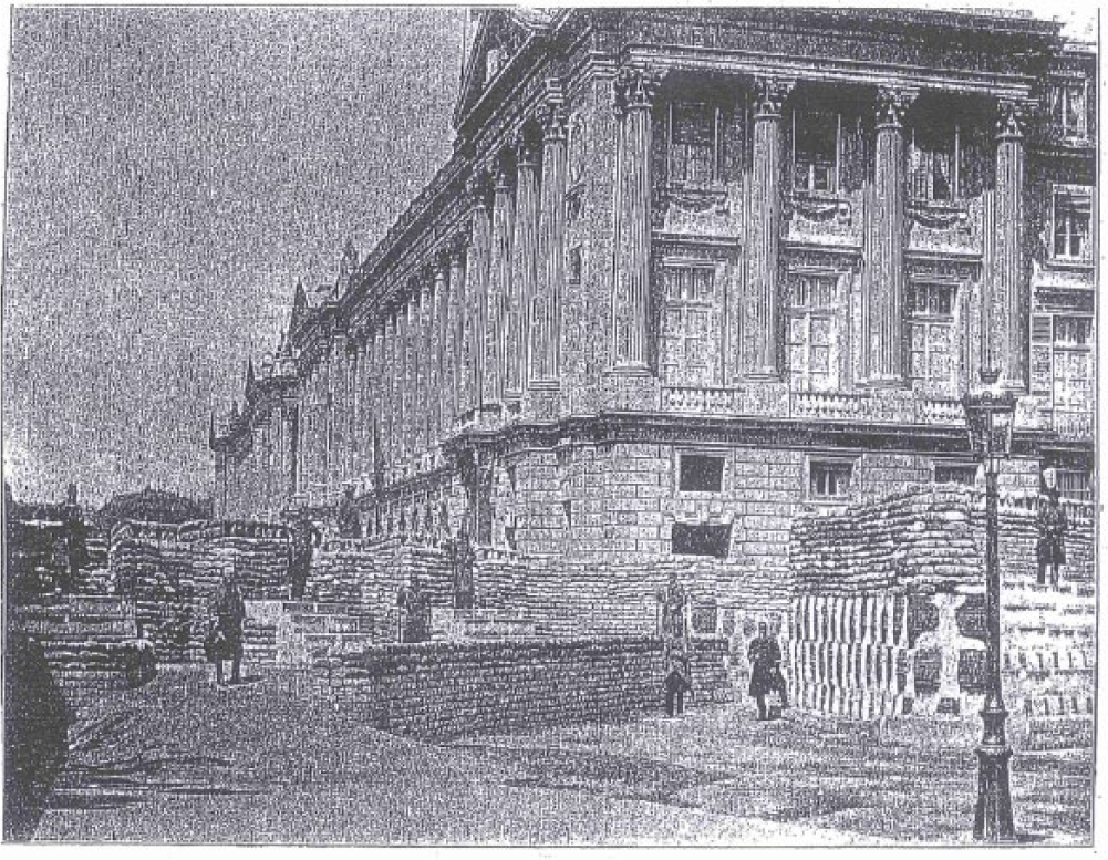
Ministère de la Marine, Barricade La Place de la Concorde, 1871.
These two central questions and the defenders and critics of Haussmann emanate from an historiographical framework that dates from the end of the Second Empire in 1870 to the First World War, the interwar period to the advent of urban history in the 1960s, and from the 1960s to the present. The Annales school in the interwar period led to a movement from political, military, and diplomatic to social and economic history, and innovative and more favorable approaches to the Second Empire. 41
In the 1960s historians focused on studies of population, public finance, and the urban transformation of Paris. More distanced politically and ideologically from the period, historians generally presented a diversity of approaches. David P. Jordan recognizes Haussmann’s ability to shape a public city through urban renewal while regarding the man with some antipathy. 42 Lefebvre, however, interprets the urban modernization as a class conflict, with the state reconquering the central space of the city to perpetuate a political and social order favorable to the capital interests of the bourgeoisie after the 1848 insurgence. 43
Relying on the Mémoires of Haussmann, de Moncan, Carmona, and Françoise Choay are favorable toward him for the most part, choosing to emphasize his positive accomplishments and downplaying the negative consequences for the working class. 44 In her recent 2013 book with Vincent Sainte Marie Gauthier, Haussmann: Conservateur de Paris, Choay confirms her reliance on the Haussmann Mémoires and uses a sequence of photographs of Boulevard Saint-Germain to show a street carefully preserved and integrated into the new system. 45 In his 2012 book Paris Avant-Après Haussmann: Rive Droite, de Moncan compares Marville’s photographs of several Paris streets with their modern depictions. 46 These historians have recently employed street photographs not merely as illustrations, but to support their arguments and to chart the preservation and changes to the built environment.
The Pedestrian Street
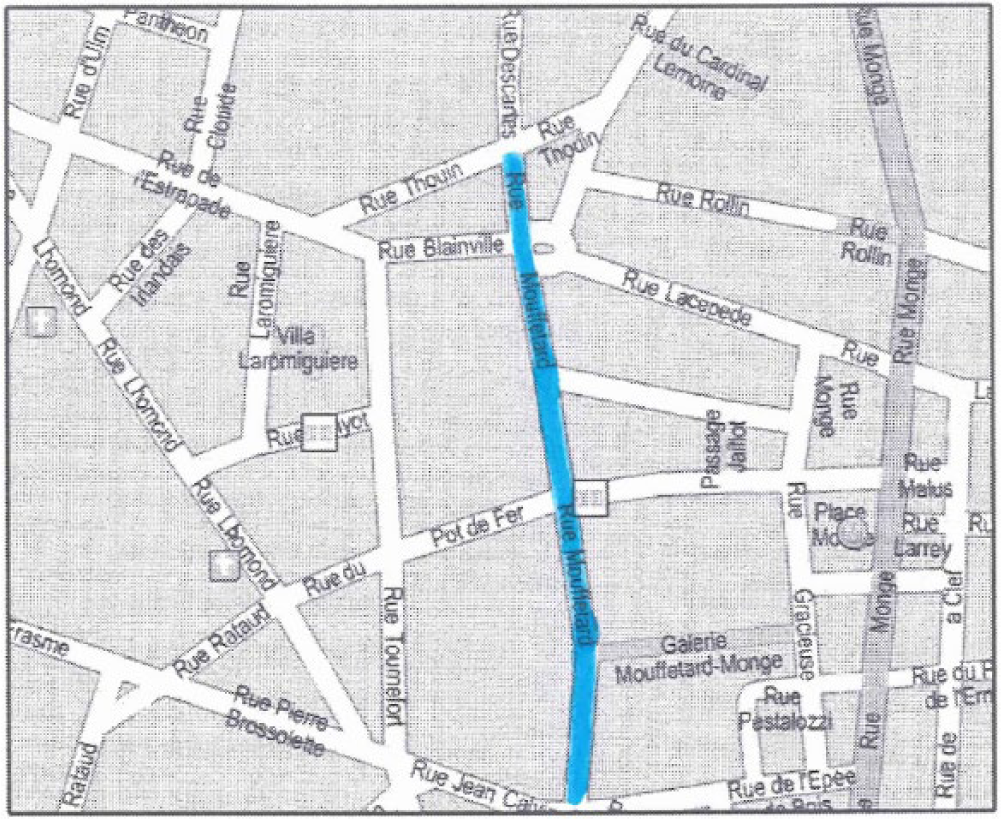
We move next to examine the form and function of a commercial street devoted primarily to pedestrians, rue Mouffetard extending 650 m (.403891 mile) in length and 7 m (23 feet) in width from Place de la Contrescarpe to the market at Saint-Médard in the fifth arrondissement on the Left Bank. This street has withstood the accomplishments of Haussmann when the southern part was cut for the renovations beginning in 1860. It defies his bourgeois design in demonstrating to what extent a commercial function can shape social usage for people, as well as for horse-drawn carts, rather than for a regional network of Parisian through streets constructed for the electrical tramway and the automobile. With nearby Boulevard Saint-Michel as a secondary commercial street and extension of the grande croisée, rue Mouffetard was a market for the purchase of fresh produce (Figures 7 and 14). The two photographs presented here draw from the Bibliothèque nationale de France VA Collection captioned Paris artistique et pittoresque. In the first 1910 shot, a crowd of women, men, and children occupy the street space, some of whom in the foreground gaze directly into the eye of the camera, whereas others focus on their trajectory, or are actively engaged in conversation with each other, oblivious to the oncoming cart. The image is of a narrow cobblestone street. The wine and cheese shops, bakers, butchers, and grocers at street level display some of the available products—in essence, the ambiance is one of social intimacy amenable to work, consumption, and celebration posing no political threat to the state (Figure 15).
Rue Mouffetard.
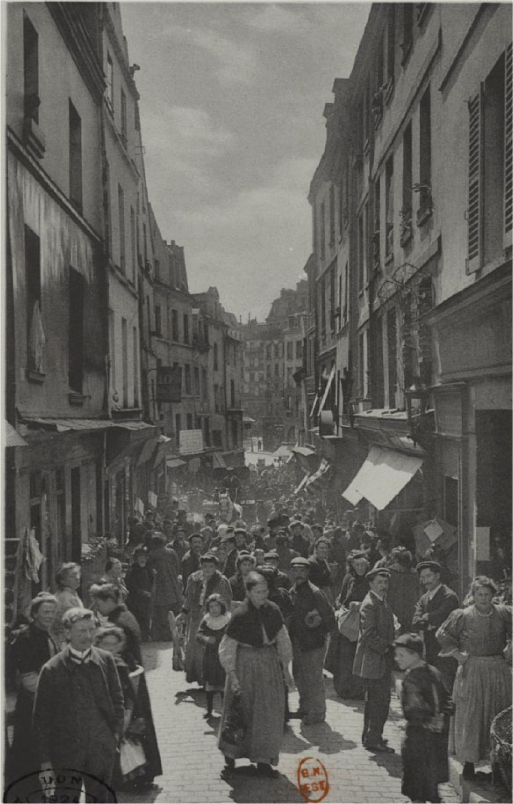
Rue Mouffetard, 1910.
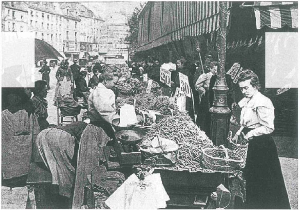
The second photograph from 1905 shows the larger market area from which the carts can negotiate into the street. Here the activity is more varied, given the open space. There are children at play, a woman involved in a direct purchase from a vendor, a male worker stationed in front of a shop, prolific advertising, clusters of people, and a café for respite (Figure 16).
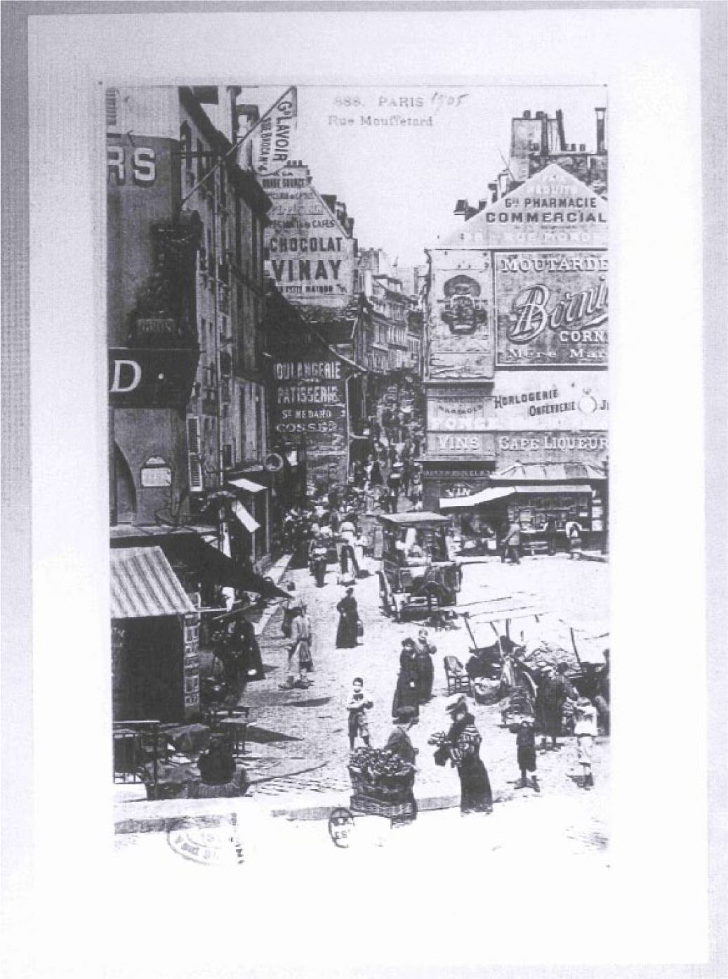
Rue Mouffetard, 1905.
An 1896 photograph offers a view of the market transactions, with vendors seated on the benches and the dominantly female clients meticulously selecting and procuring their vegetables. Spatially, the human scale of the street, the seven-meter width accommodates the market tables, the flow of pedestrian into the shops, and the onlookers (Figure 17). These photographs from the Bibliothèque nationale de France and a local rue Mouffetard website rework the city to integrate the pre-industrial pedestrian street as part of urban culture. The images make clear that working-class women were seen as central agents in market transactions, both in selling and in buying.
Paris street market, rue Mouffetard, 1896.
In Eugène Atget’s “Petits Métiers” series from 1899 to 1901, several peddlers posed for his camera in the streets of Paris “as representatives of their own trade.” Andreas Krase has observed that [P]eddlers were very much associated with Old Paris, for in the era of major department stores their lifestyle proved scarcely viable and had begun to seem archaic. Atget’s records presented them as decorative fixtures in the traditional image of the city. Theirs was the picturesque charm of anachronism. Contrary to his usual practice, Atget used a lens with a relatively long focal range, which allowed the figures to stand out from the background like silhouettes.
47
Atget has chosen in this collection to focus on the singularity of a transaction between a flower lady on rue Mouffetard in 1899 proudly clutching her long-stemmed arrangement and gazing directly into the eyes of a young man gently holding his own bouquet in gloved hands (Figure 18). In another photograph from this series, amid a newsstand and people out of focus in the background, an earnest umbrella man poses with humility and dignity in front of l’église Saint-Médard (Figure 19). The subtlety and nuance of his photographs embodied the Romantic revival of the 1890s and gained recognition for Atget as a significant figure of nineteenth-century street photography. Atget’s photographs made the old districts picturesque and the inhabitants colorful. His artistic style and composition set the stage of the street. 48 In these social documents, he infuses Paris street characters with an aesthetic, professional, and refined quality.
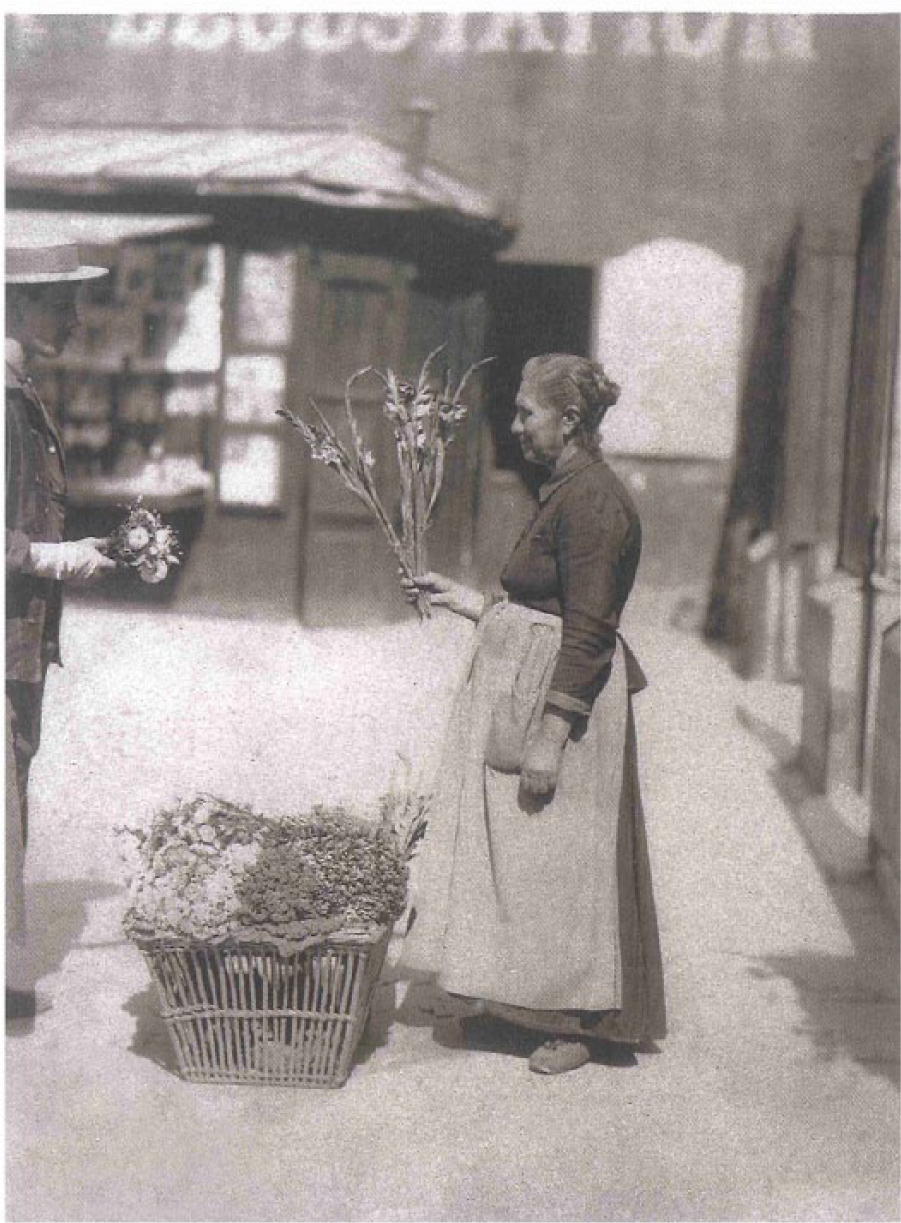
Flower lady, rue Mouffetard, 1899.
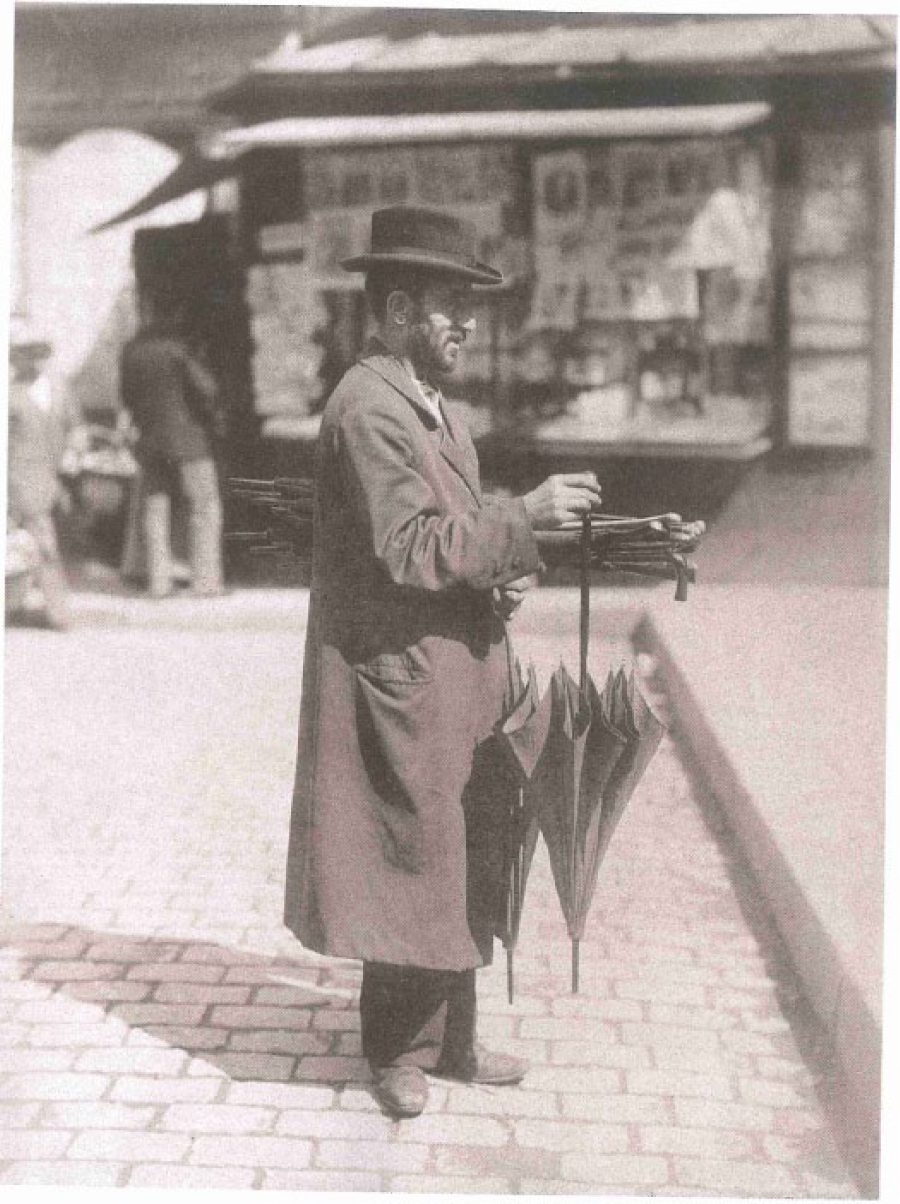
Umbrella man, rue Mouffetard, c.1899-1900.
Conclusion
This paper explores how photography and modernity are intertwined by analyzing images of late nineteenth- and early twentieth-century Montreal and Paris to demonstrate the achievement of economic goals Henri Lefebvre theorizes about in the production of social space. Photographs reveal the increasing commercialization of the retail streets of rue Notre-Dame and rue Sainte-Catherine in Montreal and the pragmatic renovations of the Haussmann through street of Boulevard de Sébastopol, together with historical documentation on the pre-industrial pedestrian street of rue Mouffetard in Paris. To a large extent, the images selected are shaped by the nature of the collections and their specific purpose. The Archives de la Ville de Montréal Institutional Affairs collection and the Bibliothèque nationale de France include images of retail, through, and pedestrian streets as various manifestations of urban culture. The photographs in Les Grande Rues de Montréal website celebrate the success of rue Sainte-Catherine as the main retail street of Montreal by the early twentieth century. These photographs from the municipal collections are generally taken at street level and from a broad perspective. Postcards are often taken from close up to stress the conviviality and sociability of street life and the transportation and street infrastructure. However, Roger Viollet’s panoramic view or vista of Boulevard de Sébastopol from overhead conveys the interior boulevard as a means of transport. Charles Marville’s photographs of the destruction of the working-class neighborhood and the desolation of the pre-existing boulevard are explicitly political in their intent to justify the reconstruction. Taken together, these photographs reinforce the goals of modernization to emphasize the accomplishments of commercialization and renovation.
Walter Benjamin alludes to the evolution of photography in early twentieth-century Paris as documenting historical occurrences especially with Eugène Atget. This phenomenon is evident in the photography of the pedestrian street rue Mouffetard, images often taken at a close range to reflect the congestion and urban traffic. Atget also documents the continuity of street trades such as peddlers in the changing urban environment. Whereas the class and gender agency of working-class women in market transactions is visible on rue Mouffetard, the class and gender composition, the female and male pedestrians on rue Notre-Dame, on rue Sainte-Catherine, and on Boulevard de Sébastopol, are largely gleaned from textual evidence. The late nineteenth-century photographs of the retail and through streets point to some bourgeois female consumption and a dominantly male workforce. The entry of women in the early twentieth-century retail and clerical sectors lends to more female pedestrians among the majority of men on rue Sainte-Catherine. From the perspective of the function of the street and social usage, photographs are critical to an understanding of urban street life. In making explicit their creation and their interpretation, my work provides a contribution to urban history through this particular use of photographs in the comparative analysis of streets.
Footnotes
Acknowledgements
I am grateful to Clayton Burrill for initial editing suggestions, to Owen Griffiths of Mount Allison University for discussion, to Kate Tilleczek of the University of Prince Edward Island for comments on an earlier version of this paper, and to the anonymous reviewers for helpful additions.
Declaration of Conflicting Interests
The author declared no potential conflicts of interest with respect to the research, authorship, and/or publication of this article.
Funding
The author disclosed receipt of the following financial support for the research, authorship, and/or publication of this article: The research was made possible by a Marjorie Young Bell Sabbatical Research Grant, Mount Allison University.