
Abstract
This article examines how midcentury European sociologists, planners, and architects mapped the existing city to build future communities. The neighborhood unit concept spread globally in the first half of the twentieth century. In Europe, its deployment was supported not just by modernist planning principles but by sociological abstractions of community life. Current scholarship emphasizes how these modernist principles were contested by sociologists. The present article demonstrates instead that sociological mapping was instrumental in making the concept of community legible and operable in the postwar European city. During the 1940s, mapping social relationships in urban space was increasingly thought to reveal “authentic” community life in working-class urban neighborhoods, which previously were dismissed as chaotic and promiscuous. Such new sociological mapping shaped, if often only implicitly, the planning and design of modern housing estates and New Towns across Europe and thus connected representations of bottom–up, grassroots communities to an essentially top–down planning apparatus.
Introduction
It is the object of planning to recognise the town not merely as an aggregate of space, buildings, and people but as the embodiment of social functions and relationships and to shape the town accordingly.
1
These are the introductory words of sociologist Ruth Glass at a conference on “Human Needs in Planning” in November 1945. 2 The architects, planners, and sociologists at the conference took as theirs the daunting challenge of rebuilding Britain after the war. In a room filled with grand hopes and bold ambitions, Glass, a German émigré who had studied sociology in Berlin and London in the 1930s, was remarkably critical of the experts’ dominant assumptions. 3 She denounced what she understood as the naive assumption that communities could be created simply through physical planning—by building so-called neighborhood units. At the same time, she insisted that urban planning was fundamentally about organizing social relationships. Sound planning was thus to be based on sociological research. To bolster this assertion, Glass presented her sociological mapping of two urban areas: Middlesbrough, an industrial town in the northeast of England, and Bethnal Green, an inner-city neighborhood in London’s East End. Using census data and household questionnaires, she determined the “catchment areas” of schools, shops, day nurseries, and so on. According to Glass, plotting the ways inhabitants used their local amenities and institutions would reveal neighborhood cohesion. Moreover, from these maps, general principles could be derived for planning new neighborhoods. 4 In the sociologist’s eyes, mapping existing “social functions and relationships” was prerequisite to their reorganization into new communities.
This article examines how midcentury European sociologists, planners, and architects mapped existing cities to build future communities. During the 1940s and 1950s, the notion of community was of crucial importance to experts and politicians across Europe, from statesmen and policy makers to social scientists, urban planners, and housing design professionals. 5 Despite this focus, community was a fundamentally contradictory concept that mobilized movements at once technocratic and spiritual, nostalgic and forward looking, progressive and reactionary. To understand how these contradictions shaped the postwar city, this article explores the genealogy of community in European sociology and urban planning as well as the multiple dimensions of modernity it mobilized. The mid-twentieth-century discourse of community needs to be understood as profoundly transnational in the context of World War II and the emerging Cold War order. Despite the global spread of the neighborhood unit concept in the first half of the twentieth century—from American Greenbelt towns to Soviet microdistricts—its deployment in Western Europe was supported not just by modernist planning principles but by sociological abstractions of community life. To trace the influence of these abstractions, this article focuses on the sociology and planning of London, Rotterdam, and Paris in the 1940s and early 1950s.
My argument is that the imaginary of community and its deployment in the postwar city depended on the visualization of sociological knowledge. Twentieth-century sociologists understood the city as human ecology and were thus able to analyze community by mapping social relationships onto urban space. Such sociological mapping of the existing city made the concept of community not only legible but also operable. The visualization of sociological knowledge—as Glass demonstrated during her presentation at the 1946 conference—allowed community to become a key instrument of planning in the postwar European city.
Mapping has long served as a way not just to understand but to remake the city. Maps are not just diagrams or representations of an objective reality but instead help produce such realities. Over the course of the nineteenth and twentieth centuries, maps became visual repositories of increasingly detailed scientific knowledge. 6 As it turned the city into an apprehensible object, scientific mapping was a powerful handmaiden of urban governance and modernization. 7 Whether assisting in controlling colonized populations overseas or reforming the working classes of the industrial city, maps made certain social categories and spatial qualities seem universal while relegating others to the margins of aberration or peculiarity. 8 The seemingly natural legibility of the map renders invisible the politics of calculation and the violence of abstraction that go into their production. The map not only visualizes the present but serves as a technique to imagine the future. Hence, mapping was instrumental to the development of modern urban planning. 9
The work of Glass and others, however, suggests that sociological mapping was no longer so clearly aligned with the dominant ideology of urban modernization. Christian Topalov cogently demonstrates how postwar sociologists such as Henri Coing, Herbert Gans, Michael Young, and Peter Willmott recast urban areas that planners commonly called “slums.” Rather than chaotic, promiscuous, or degenerative, their studies of the late 1950s and 1960s showed them instead as highly structured places in which the density of face-to-face contact and tightly knit social fabric produced an intimate sense of community. 10 Yet this epistemological shift happened more than a decade earlier, and Glass, Paul-Henry Chombart de Lauwe, and groups such as Économie et humanisme were instrumental in making working-class neighborhoods visible in this light. While such a shift in periodization might seem minor, it is crucial because it shows that the interactions between sociology and planning, between mapping and making the postwar city, are more complex than current scholarship reflects. Not only were inner-city neighborhoods “discovered” at the time they were threatened by demolition for the sake of modern housing estates and New Towns, the sociological abstractions of urban life derived from such discovery, in fact, shaped some of the very principles underlying the modernization of the European city. Social cartography thus implied models for building community in the postwar city. Made legible in such terms, community allowed European planners and policy makers to cast postwar (sub)urban development as a projection of a communal past into a communal future. As such, they connected representations of bottom–up, grassroots communities to the bureaucracy of an essentially top–down planning apparatus.
Unlike the Chicago School sociologists or the authors of Geddesian civic surveys in Britain earlier in the century, mid-twentieth-century sociologists subverted as much as naturalized the social abstractions underlying modernist urban visions. Even as they relied intellectually on forerunners such as Patrick Geddes, they forged a critical opening between their research and planning practice. That opening would become an inevitable rift, as planning and sociology diverged to become almost incommensurable disciplines over the following decades. 11 Yet, sociologists such as Glass still aimed to help shape the future city. They did so by mapping the existing city in search of community. But what kind of community was this, and how could it be found?
A Genealogy of Community
Faced with cities and landscapes torn by war, Europeans aimed to rebuild communities as the cornerstone of the city and the nation. Planners believed that community could be created by following the rational principles of the “neighborhood unit,” arguably the single most important concept in mid-twentieth-century planning. 12 The resurrected, postwar city was to be a “cluster of communities.” Yet, building community was not a project that arose from the ashes of World War II. In fact, the community ideal can be understood as a fundamental trope of European modernity and a recurring response to the unsettling effects of industrialization and urbanization since the nineteenth century. 13 European social and urban reformers upheld the romantic image of premodern village life as a solution to the contemporary problems of the industrial city. They saw in it the realization of community life: a largely self-governing group of people, with the village school as a central institution. Across the twentieth century, advocates of community building followed in the footsteps of nineteenth-century reform movements, such as the garden city and settlement house movements. 14
Many of the reformers’ underlying assumptions were supplied by sociologists. Ferdinand Tönnies’s distinction between Gesellschaft (society) and Gemeinschaft (community) has so thoroughly shaped dominant views of metropolitan life that it has become difficult to think the city without it. 15 The association of the city with alienation and individualism was reinforced by contrasting it with the imagined intimacy and face-to-face relationships of the traditional village. Consequently, social scientific study tended to diagnose the metropolis as a fundamental uprooting from timeless tradition. Of course, this concept of tradition was as modern as the metropolis itself. Yet the distinction structured much of twentieth-century European thinking and social science, and it allowed the modern city to be problematized as threatening the loss of a socially cohesive fabric. For many planners, the solution was self-evident: the future was in a “return” to community. Such an antiurban view shaped modern planning from Ebenezer Howard to the European reconstruction plans after World War II.
The biological metaphor of Entwurzelung (uprooting) in sociological theory was thus not incidental. Seeing community as “organic” and the city as the “artificial” product of modernity resulted from the translation of biological concepts into social science during the second half of the nineteenth century. Sociologists frequently applied biological theories to explain the evolution of human society. The theories of Geddes, a biologist as much as a sociologist and town planner, were inspired by Herbert Spencer, the proselytizer of “social Darwinism.” 16 Consequently, Geddes understood the city itself as a life form. With the turn-of-the-century development of ecology, new transpositions into sociology occurred. The ecological concept of habitat, for instance, suggested a causal relationship between human beings and their environment; its use in modern architecture and planning became widespread in the twentieth century. 17 Such theoretical borrowings made sociology and urban planning commensurable disciplines. Consequently, the concept of community inherited the assumption that spatial proximity equaled social bonding.
This ecological conception of community became further entrenched when sociological ideas traveled across the Atlantic and informed the Chicago School of Sociology. 18 Clarence Perry was fundamentally inspired by these sociologists’ approach to the city as human ecology. Together with Charles Cooley’s research on the spontaneous sociability of what he called “primary groups,” the ecological approach informed the “neighborhood unit” concept, which Perry developed in the context of the 1929 Regional Plan of New York and Its Environs. 19 The concept was enthusiastically received by planners and was promoted as a universal planning tool, becoming a “universal” technique that could be applied “locally” to different conditions. Underlying such applications was the idea that social life could be plotted in space and, reciprocally, that physical space could shape the social life within it.
The spread of the neighborhood unit concept was part and parcel of the transnational diffusion of planning ideas and the growing importance of expert culture during the twentieth century. 20 World War II was hardly a barrier to such exchanges across national boundaries. On the contrary, the war offered one of the most dynamic contexts for the diffusion of planning and architectural concepts across Europe. 21 And after 1945, the neighborhood unit concept was inscribed in the rise of Cold War expert culture. 22 In postwar Europe, it was used almost interchangeably with the term community and was often cast as grassroots solidarity. 23 The roots of such urban thinking, however, lay in the technocratic turn of European politics during the 1930s. 24
The fundamentally technical rationality of the neighborhood unit concept went hand in hand with an explicitly spiritual approach to community. Many of the lofty human values accompanying the idea of community in the minds of planners were based on the experience of wartime solidarity and mutual aid. This ambiguity—dually rational and spiritual—at the heart of the neighborhood unit concept was most clearly pronounced in the Rotterdam reconstruction plan published in 1946 as De Stad der Toekomst, de Toekomst der Stad. The plan was established by the Bos study group, which included prominent Dutch modernists and was established in 1943 by the then director of the Rotterdam Housing Service, A. Bos. The group understood postwar planning as primarily a response to the spiritual uprooting of war. 25 That is, they cast the emergence of community in the city not as a result of industrialization, but as a consequence of World War II. Even the modernist architect Willem Marinus Dudok, who remained more skeptical of such idealistic ambitions, understood the postwar desire for community as a reflection of wartime solidarity. 26 The Bos group was one of the most vocal advocates for the neighborhood unit, translated into Dutch as the wijkgedachte. Over the following decade, various Dutch experts sought to realize these visions of community. The geographer W. F. Geyl described urban life as unnatural, mechanized, and alienating. The answer was in “spiritual renewal” through the construction of communities. 27 Despite the dominant antiurban ideology of modern planning, European planners were not purely nostalgic in their longing for community. The idea of the neighborhood as a premodern village was highly contested, and some dismissed it as nothing but a romantic imaginary. 28 Planners, however, did not so much desire to escape the modern city as to humanize Gesellschaft with the edifying qualities of the neighborhood as Gemeinschaft. Urban communities should not be built in the image of the preindustrial past; they were meant to foster personal and collective development. 29
The paradoxical nature of community as a planning concept is further revealed by the divergent political ideals it mobilized. In postwar Europe, the idea of community building was to be cast as an explicit defense against the tendencies of totalitarianism. The lack of human encounter in the metropolis—with its “mindless juxtaposition of streets”—would create alienation and isolation, the “raw material” of fascism. The anonymity of mass society would induce people to “follow leaders uncritically.” 30 This was intellectual acrobacy: Nazi ideology was itself fundamentally großstadfeindlich (against the metropolis), and its ideologues similarly cast community as the solution to modern anomie. In fact, Andreas Walther, who succeeded Tönnies’s chair position in sociology at the University of Hamburg in the 1930s, followed the human ecology model to map Hamburg neighborhoods with the goal of urban renewal. In his work, social and political deviance were mapped spatially, made visible, and therefore helped the idea of “weeding out” the bad “anti-community” elements. 31
Zygmunt Bauman argues that the desire for community is part of the radical Ordnungsdenken that made Nazism possible. 32 David Kuchenbuch, however, has shown more recently that social engineering, as a reaction to modernity, was not particularly German but rather fundamentally transnational and transpolitical. 33 In Sweden, for instance, the concept of community or folkhem became central to the ideology of the welfare state and helped articulate a political middle way between totalitarianism and liberalism. While German planners implicitly relied on Tönnies, Swedish planners based their ideas mostly on Americans such as Charles Cooley and Lewis Mumford. The notion of community in planning was thus the product of a transnational discourse, even if it could be cast as a distinct political or national cause. While the Nazis understood community building as a totalitarian solution to the social fragmentation of the metropolis, community building could just as easily be cast as a way to build democracy and foster social justice. And that is precisely what happened across Europe during the second half of the 1940s.
Postwar intellectuals understood the chaotic, unbridled capitalist city as the environment of the atomized individual. Personal development was possible only if harsh, materialistic individualism was tempered by the spiritual experience of community life. The Rotterdam plan promoted community in these terms as the precondition of individual growth. 34 The neighborhood unit concept became a convenient tool to achieve these ambitions: it was a spatial frame that would engender both personal development and community life. To achieve the latter, neighborhoods needed to be spatially bounded and harmoniously connected to a larger whole. Instead of an idyllic return to the medieval village, its chief characteristic—namely, a “compressed and organized, orderly society”—could be recreated by careful planning and design. At the time of these debates, large swaths of existing urban fabric and suburban land across Europe were being cleared at unprecedented speed to create new “communities,” from housing estates to entire New Towns. Ironically, the desired attribute of these newly planned environments—a vibrant community life—was palpable only in exactly those parts of the city slated for demolition and renewal. The concept of community tied the city of the past to that of the future in contradictory ways.
Utopia in Reality
European planners during the 1940s and 1950s relied on maps of the existing city in their efforts to plan for the future. Yet in contrast to their early twentieth-century predecessors, whose maps had recast the entire city as a circulatory system, they used the transportation network to reorganize the city into a cluster of strictly delineated, stable communities. 35 The reconstruction plans for London of 1943 to 1944 and for Rotterdam of 1944 to 1946 make that shift most evident. These plans illustrate how mapping the existing city became instrumental to the conception of almost-utopian renewal plans. Social cartography helped urban planners to read the existing city as a cluster of communities and thus to project the future in such terms.
John Henry Forshaw and Patrick Abercrombie’s 1943 County of London Plan set the tone for British town planning throughout the postwar period. 36 While the concept of the neighborhood unit had emerged in British planning discourse during the 1930s, their plan gave it international prominence. 37 Heavily influenced by Perry’s work for New York City, the planners assumed the family as the primary “biological unit” for the city. On this basis, they proposed mixing social classes in distinct scales of settlement. According to Abercrombie, human beings had a strong natural tendency to live together in a neighborhood when possible. Hence, the plan proposed the creation of “residential units” of about 1,000 inhabitants that would be clustered into “neighborhood units” of 6,000 inhabitants. A borough comprised nine such neighborhood units, and multiple boroughs would equal the city at large. 38
The planners claimed that this nested organization mirrored the structure of London as it was. Their survey of the existing city revealed a highly organized and interrelated system of such communities. This system, so they argued, needed to be kept and reinforced as one of the main characteristics of the future city. 39 Yet that required drastic action: the challenge was to retain the old structure and to make it “workable under modern conditions.” 40 When mapping London’s existing neighborhoods, the planners saw “neighborhood units” in embryonic form. As such, they read their own utopian plans into the existing city. Forshaw and Abercrombie did not invent this approach but rather synthesized different planning visions in circulation in Britain at this time. Mapping in particular had a central place in many wartime visions and plans. 41 The bubble diagram of the city shown in the County of London Plan, drawn by Arthur Ling and D. K. Johnson, represents London as a conglomerate of villages (Figure 1a). The diagram was based on a careful delineation and sociological abstraction of existing neighborhoods (Figure 1b). The planners also analyzed particular neighborhoods, such as Eltham in Southeast London (Figure 2). They mapped social institutions, particularly schools and places for shopping, and assumed the existing pattern of main roads would naturally divide the district into distinct neighborhoods. Each school or “shopping center” was then designated as the center of its own neighborhood “unit.” Urban spaces and features that did not correspond to this structure—for instance, Eltham’s historic main shopping street—were labeled as aberrations. Such mapping exercises thus allowed planners to conclude that “communities themselves consist of a series of sub-units, generally with their own local shops and schools, corresponding to neighborhood units.” 42
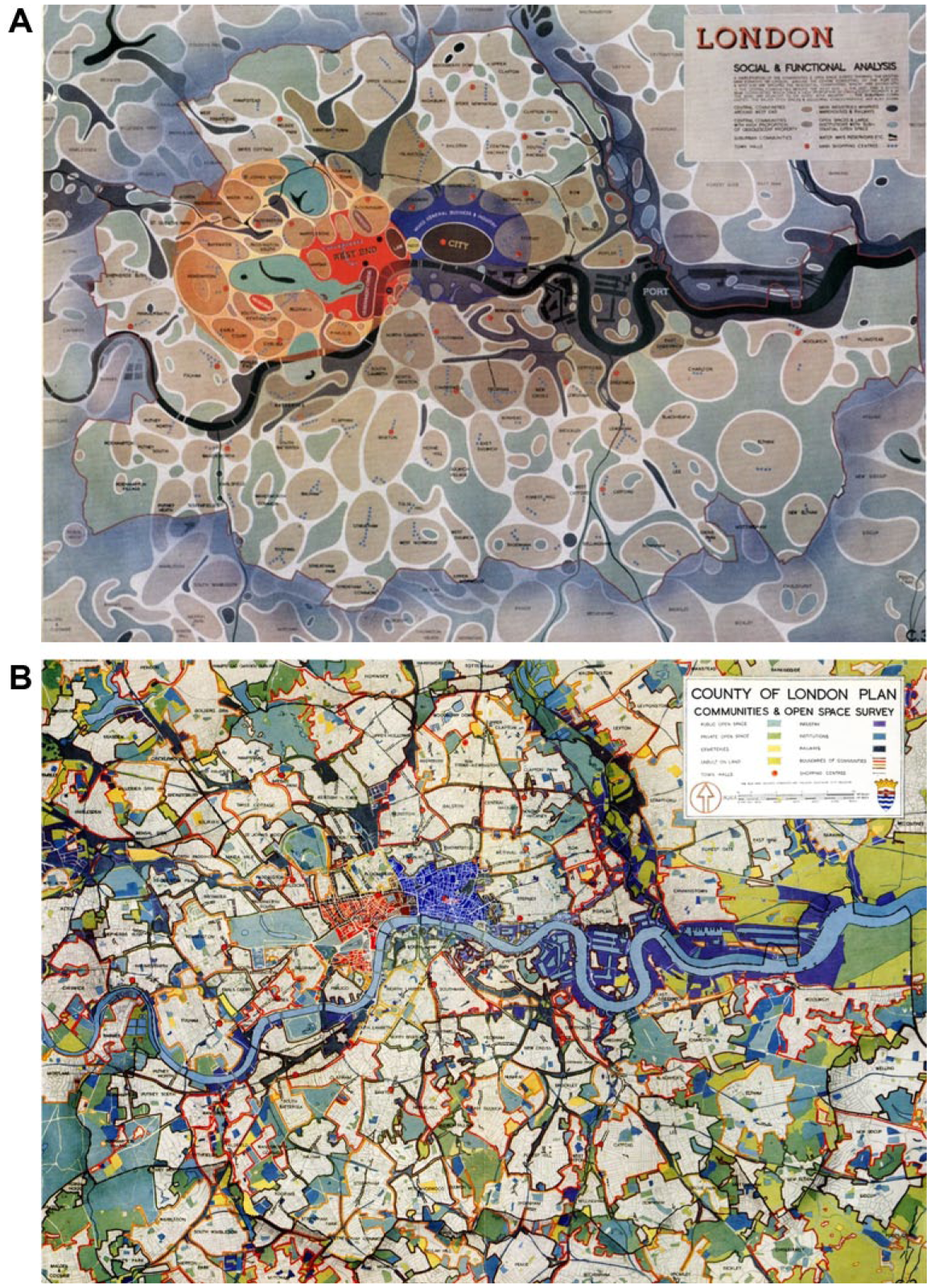
The bubble diagram of London (a) was based on a sociological reading of the existing urban fabric (b).
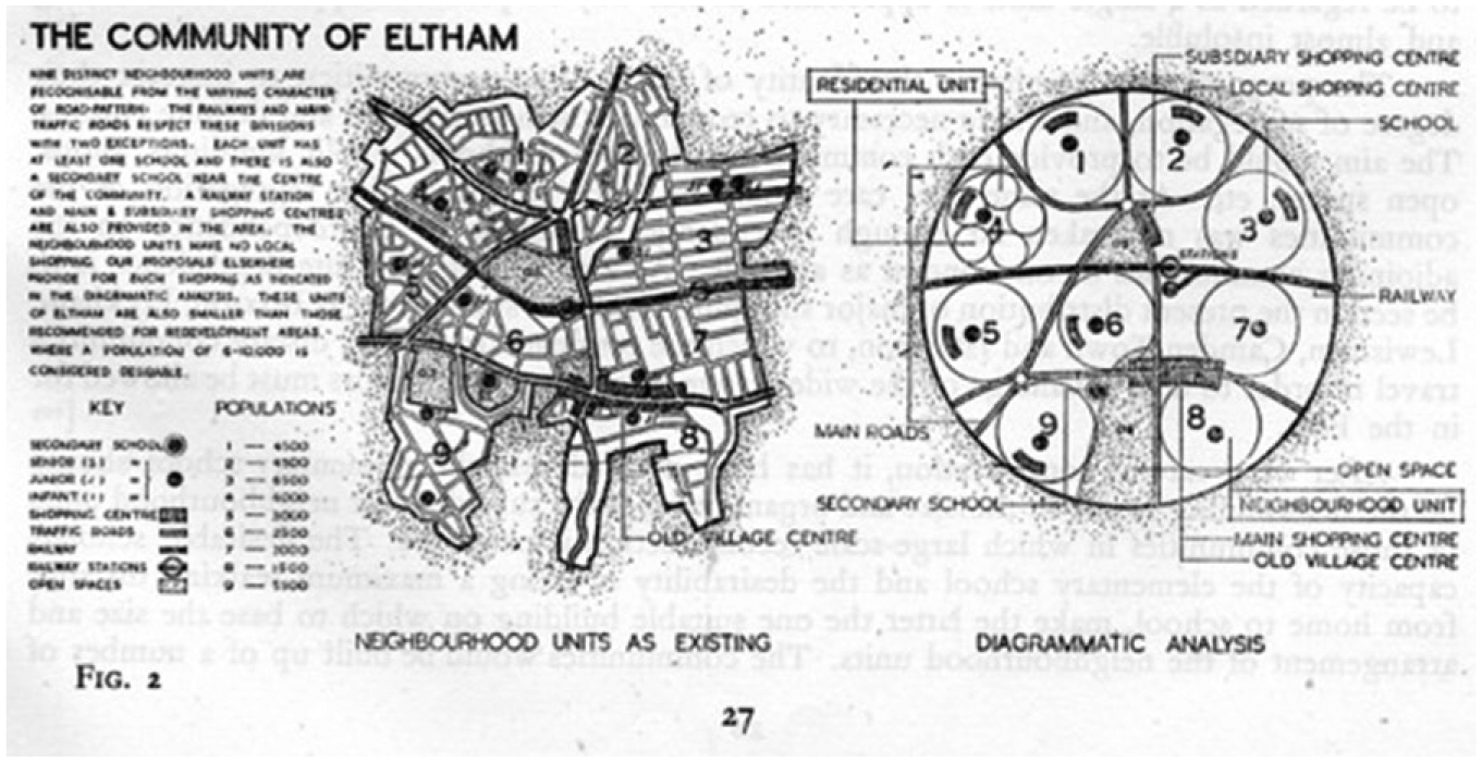
Eltham interpreted as a neighborhood unit.
This conception of the city as a cluster of neighborhood units recalled the idealization of the preindustrial village with its school as the central institution. Yet the plan was also, and increasingly, based upon a rereading of the industrial city as planners found it. As such, the antiurban ideal of village life lost influence, and the neighborhood unit concept was increasingly based on the visualization of existing, often working-class neighborhoods. The representation of such neighborhoods was itself rapidly changing. Most mid-twentieth-century planners and architects were still indebted to social reform ideology, which cast the working-class “slum” as a degenerative environment in need of improvement. The County of London reflected this dominant ideology: the districts that planners found difficult to cartographically transform into “neighborhood units” were all industrial, working-class parts of the city: There are those isolated pockets of housing, chiefly in the dock areas, which are surrounded by industrial and railway barriers, and are cut off from the major communities. In most cases they are too small in size to rank as communities, and the living conditions of their inhabitants are detrimentally affected by the adjacent industries.
43
In the course of the 1940s, the perception of such areas changed significantly. Working-class areas were increasingly upheld as the last vestiges of “real” community life.
The planners of postwar Rotterdam at this time were equally insistent on reading community into the existing city. Their reading was based on similar ecological concepts of the city: “We discover in the first instance a set of concentric circles around the individual within the city: the dwelling, the neighborhood [buurt], the district [wijk], and the urban ensemble [stadgeheel].” 44 The realm of the private dwelling was the precondition for any form of community in planners’ eyes. The circle of the neighborhood was the place for children to play, for women to attend to family life, and for the family to enjoy leisure time together. The much larger circle of the district was considered the extremity of the inhabitant’s comprehensible lifeworld. 45
Even though planners were focused on defining the optimal size of neighborhood units, their social cartography was not limited to quantitative evidence. For example, in their study for Rotterdam’s reconstruction plan, planners focused on existing urban districts such as Oude Noorden (Figure 3a) and Vreewijk to extract the essential characteristics of community. Such research was to inform the planning of new districts, including Zuidwijk (Figure 3b). 46 Oude Noorden was a working-class neighborhood built up incrementally by commercial builders from 1880 to 1920. Vreewijk, by contrast, was a modern garden city carefully planned by Hendrik Petrus Berlage in the interwar period. Both districts were diagnosed with a lack of collective facilities. Yet while the modern garden city was criticized for its absence of community life, Oude Noorden was hailed for the liveliness and community atmosphere of its dense urban fabric. This was a reversal of earlier modernist dogma, which would have led planners to dismiss Oude Noorden as a slum. The future district of Zuidwijk needed to be radically different from both the traditional and the interwar modernist urban form. Unlike Vreewijk, it was to be focused on two urban centers offering a panoply of amenities and activities. Formally, the Zuidwijk plan inverted the formal relationship between figure and ground of Oude Noorden. The traditional urban morphology of streets and perimeter blocks was now anathema to the modernist language of slabs and blocks on a field of green space. Yet, at the same time, Zuidwijk was meant to reproduce the community spirit of Oude Noorden. How could such reproduction—from the decrepit alleyways of the old city to the glistening modern environment of the new “neighborhood unit”—be achieved? What was required, planners insisted, was empirical studies and scientific measurement of community life in the existing city.
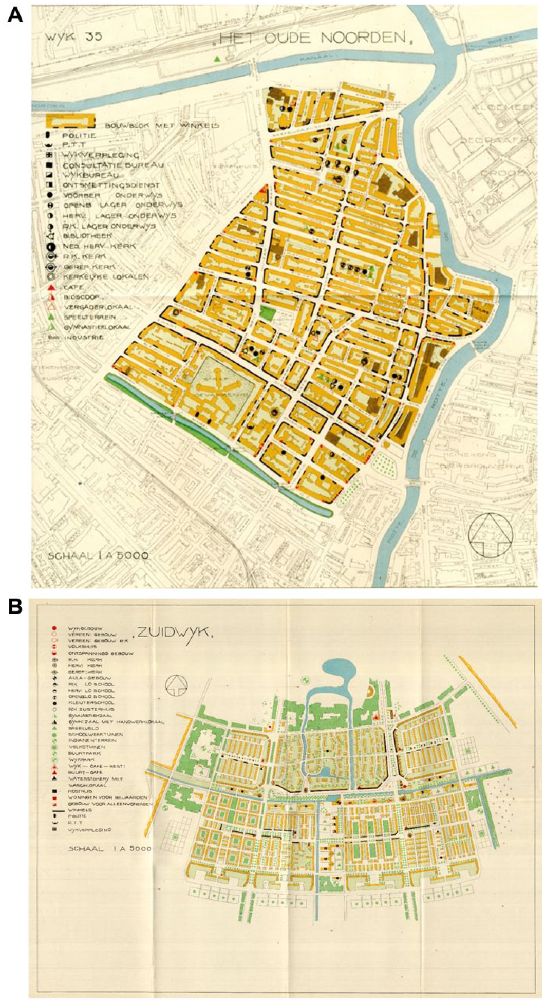
Map of the existing neighborhood Oude Noorden (a) and the newly planned Zuidwijk district (b), using the same graphic conventions. The keys list a variety of collective amenities.
Measuring Community
The question of how to measure community is exactly what drove Glass’s sociological research in Middlesbrough during the 1940s. The study was part of the Middlesbrough Survey and Plan, directed by Max Lock in his capacity as town planning consultant to the County Borough of Middlesbrough. 47 Like Glass, Lock was a staunch supporter of the use of sociological research in planning and considered the city’s social and economic dimension to be as important as its physical dimension in planning. He personally directed the survey of physical planning and commissioned Arthur Smailes for the geographical and economic survey and Glass for the social survey. Glass’s work during the 1940s was inscribed in a larger movement of British left-wing intellectuals who aimed to portray everyday working-class life “from the bottom-up.” 48 While she cast working-class culture as a resistant but progressive force in British society, she also believed in the merits of state-led planning.
Middlesbrough was an iron and steel town laid out in a gridiron pattern. Like so many northern English towns, it was the product of rapid industrial growth during the nineteenth century. The town was clearly segregated along class lines, with poor unskilled laborers to the north and the middle classes to the south. Two housing estates formed the southeastern and southwestern fringe of the town. Glass perceived the town’s dispersal and mixing of housing and industry as amorphous and disorganized. With the eyes of a planner as much as a sociologist, she saw “a town which lacks cohesion so markedly [that it] is urgently in need of a centre to pull all its component parts together.” 49 Glass’s perception was shaped by the enormous popularity of the neighborhood unit concept in planning discourse at this time. Most planners tended to assume that when people “can meet each other easily, they are inclined to become a group.” 50 Glass, however, was critical of the assumption “that people will become ‘neighbourly’ merely because they live in a neighbourhood unit.” 51 While she accepted the community building as the central ambition of postwar planning, she dismissed the “romantic intentions” of the neighborhood unit concept. Her response as a scientist was to examine the validity of its underlying assumptions.
She began by distinguishing the terms neighborhood and community. The first she defined as an area of the city defined by physical and social characteristics, the second as “a territorial group of people with a common mode of living, striving for common objectives.” Thus, a neighborhood “is not yet, but may well become a part of a ‘community.’” 52 Assessing the presence of a community, she continued, required a careful study of the sphere of influence of local amenities and institutions. If local inhabitants shared the same church or school, it was likely that they shared a certain way of life. And such sharing could be shown in what she called “catchment area maps of the relevant institutions” (Figure 4a). 53 Glass assumed that a social condition—shared values among groups of people—was directly reflected into a spatial configuration. And, therefore, mapping such configurations would reveal social conditions. The human ecology of the Chicago School sociologists was not hard to find in this logic.
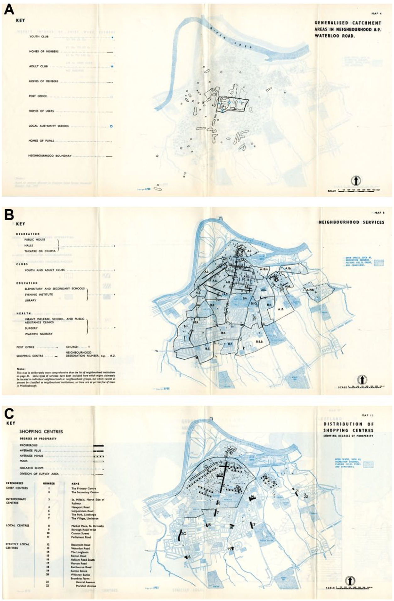
Ruth Glass’s sociological mapping of Middlesbrough.
Glass realized that such mapping required intensive sociological research on the variety of formal and informal institutions within a neighborhood. Time and budgetary constraints, however, imposed a more restricted focus—on what she called “essential and organised activities.” 54 Glass demarcated distinct territorial groups by means of indices such as the age of buildings, population density, and birth and infant death statistics. Geographic overlaps of such indices then helped her to delineate distinct neighborhoods (Figure 4b). She then looked for attributes of “neighborliness” by analyzing the catchment areas of elementary and secondary schools, post offices, youth clubs, grocery stores, day nurseries, church clubs, settlements, public libraries, and so on (Figure 4a). 55 Glass drew an individual map for each institution showing its location and its catchment area. These maps made it possible not only to see the spheres of influence of the different institutions and to compare them but also to distinguish the geographical distribution of their different sex, age, income, and interest groups. Glass pursued a similar study for Bethnal Green at this time. The sources she used for this assessment included published statistics and census data, unpublished administrative records, general fieldwork, and specific field enquiries. She also interviewed officials and representatives of local organizations and visited neighborhoods and observed the use of their institutions. 56
The ultimate goal of Glass’s study was twofold. Her research was to contribute to sociology, but she was also interested in applying her findings to future policy and planning. She emphasized the experimental relationship between research and action and dismissed dogmatic or universal rules in planning. Nevertheless, based on her research, she formulated certain principles for neighborhood planning. Despite the many differences between Middlesbrough and Bethnal Green, the spheres of influence of their comparable institutions were remarkably alike, she claimed. “Both surveys showed the same and repeated differences between the catchment areas of certain types of institutions. Both showed the same patterns of movement for specific groups of people.” 57 Some universal principles could thus be formulated. For instance, she found that “the more specialised an institution or a particular activity is, the wider and the more dispersed is its sphere of influence.” 58 Another finding was that catchment areas varied by specific groups: “Young children, mothers with young children, and also, but to a lesser extent, old people, usually live in the immediate vicinity of the institution which they attend.” 59 Not surprisingly, Glass found that poor people were far more tied to their districts than wealthy and that, because of this, poor neighborhoods were more self-contained. 60
Glass nevertheless insisted that there was no ideal plan that could simply be applied universally and that a newly planned neighborhood could never “resemble a village and become a self-contained unit.” 61 At the same time, her research generated general principles for the distribution of the relevant institutions, “adjusted to the size and characteristics of [these] particular groups within a given population.” 62 Consequently, Glass proposed that planners, based on her research method, grade neighborhoods in terms of their cohesiveness. Because the immediate social consequences of uprooting them would be severe, the most “neighborly” neighborhoods should be treated carefully: “If upheavals are necessary, the people from any one of these territorial groups should be shifted simultaneously and swiftly.” 63
Spatial proximity, so the study demonstrated, was a relative and not an absolute factor of neighborhood cohesion and depended on age and social groups. Mothers, children, and old people, who are all more closely tied to their homes, are naturally most dependent on facilities within easy reach. Thus, in contrast to the underlying assumption of neighborhood unit planning, spatial proximity did not automatically lead to social mixing or a dense community life: The mere shortening of the physical distance between the different social groups can hardly bring them together unless, at the same time, the social distance between them is also reduced. Hence the solution of “social mixing” in residential units, which is so often advocated, appears to be rather unrealistic.
Yet Glass did not refute the influence of the environment altogether. Despite her critique of deliberate or explicit attempts at social mixing, she claimed that improving inhabitant’s everyday environments, the very job of physical planning, could ultimately prove to be a more effective if implicit way to achieve the ideal of the socially mixed city: People who live in slums and people who live in suburbs do not have very much in common. But they might get to know each other far more easily when the old contrasts have been obliterated, and when houses and amenities vary according to family size and need, rather than according to income.
64
Ultimately, Glass’s maps reinforced the notion of community as central to postwar urban planning, even if her research showed that, in fact, only a few neighborhoods possessed the specified attributes of community. Perhaps not surprising, those that did were the working-class urban areas that many planners regarded as being in urgent need of renewal. Glass concluded that the presence of community “was associated with a combination of negative factors at present, at least in Middlesbrough, and there is no reason to assume that it is so in Middlesbrough alone.” Therefore, she asked, “how can it [community] be recreated? It now exists in the setting of poverty and geographic isolation. Can it now grow as the result of alternative conditions?” 65 Sociological knowledge, such as that produced by Glass, helped to shift the dominant perception of inner-city, working-class neighborhoods such as Bethnal Green. In doing so, she provided a powerful imaginary for urban planners to project community onto the postwar city. 66
Reproducing Community
Similar applications of sociological research to urban planning were sought in midcentury France. Like Glass, the sociologist Chombart emphasized the potential applications of his scientific research to state-led planning and housing policy. Chombart was the most influential advocate of such applied sociology in postwar France. 67 Unlike most British sociologists and planners, who were influenced by Geddes’s surveying approach, Chombart’s intellectual background was in the sociology of Maurice Halbwachs and the anthropological research of Marcel Mauss and Marcel Griaule. 68 Yet this intellectual provenance led to a similar approach to the relationship between spatial and social organization. In addition, Chombart had experience as a pilot, and the aerial view profoundly influenced his research. Aerial photography allowed scientists such as Chombart to connect the view from above to the social reality “on the ground.” 69 Just like Glass, albeit via a different route, Chombart thus arrived at mapping as a central method of his sociology. During the late 1940s and early 1950s, Chombart was particularly interested in mapping working-class Paris. This interest was informed by his adherence to the French Catholic Left, in particular, the group Économie et humanisme. 70 Committed to poverty relief in urban France, this group had pursued detailed surveys of working-class areas. 71 The surveys were guided by the belief in a strong communitarian spirit. This also informed Chombart’s work and his solidarity with the French working classes. 72
The results of Chombart’s exploration of working-class Paris were published in 1952 as Paris et l’agglomération parisienne. Analyzing both the social and spatial organization of the Paris region, this study combined aerial photographs and maps, drawn by Louis Couvreur, with detailed accounts of the city’s physical fabric and everyday life. Chombart was in search of community, just like Glass at this time. What he found—namely, that communities naturally occur in spatially cohesive, bounded areas or neighborhoods—did not exactly correspond to the dominant views of planners.
The neighborhood unit concept was popular in France just as it was elsewhere in Europe at this time. Gaston Bardet, who was closely linked to the movement of Économie et humanisme, was the most influential advocate of the concept in France. Bardet positioned himself explicitly against what he saw as the excessively functionalist approach of the International Congresses of Modern Architecture (CIAM) and understood community building as a humanizing of modernist planning. This ideal of community was not based on modernist principles, so he claimed, but rather on the city as it was; namely, “a cluster, a federation of communities.” 73 Concepts such as “cluster” and “community” were thus used both to describe the sociospatial structure of existing cities and to project a novel, “organic” structure for new urban development. Chombart’s sociological mapping refuted simple claims about the existing city as a cluster of enclosed communities. And yet, by examining the extent to which “community” existed in metropolitan Paris, the sociologist unwittingly reinforced the legitimacy of the neighborhood unit concept.
In fact, Chombart’s sociological research directly informed the work of planners and designers, most notably in the project for the Cité de la Plaine by the architect Robert Auzelle. This mass housing project was to be located in the southern suburb of Clamart, an area Chombart was studying at the time Auzelle was commissioned for its design. 74 Since 1947, Auzelle had been in charge of urban renewal at the Ministry of Reconstruction and Urbanism, where he had developed a new method of surveying based on studies such as those by the group Économie et humanisme. While these surveys were undertaken with the ultimate aim of demolishing working-class slums, they demonstrated rich community life and inspired architects such as Auzelle. The architect and the sociologist thus shared similar convictions about the importance of community in the postwar city.
When Auzelle was asked to design the master plan for the Cité de la Plaine, he insisted on using Chombart’s sociological study of the local area. Using aerial photographs and maps, Chombart had traced the fragmented little neighborhoods of suburban allotments of which the area was made up. He mapped clusters of small shops and amenities and analyzed the area’s social meeting places, recreational spaces, and existing public services. The result was a rich picture of the area’s social life as shaped both by its geographic isolation from Paris and by its economic and social dependence on the capital (Figure 5).
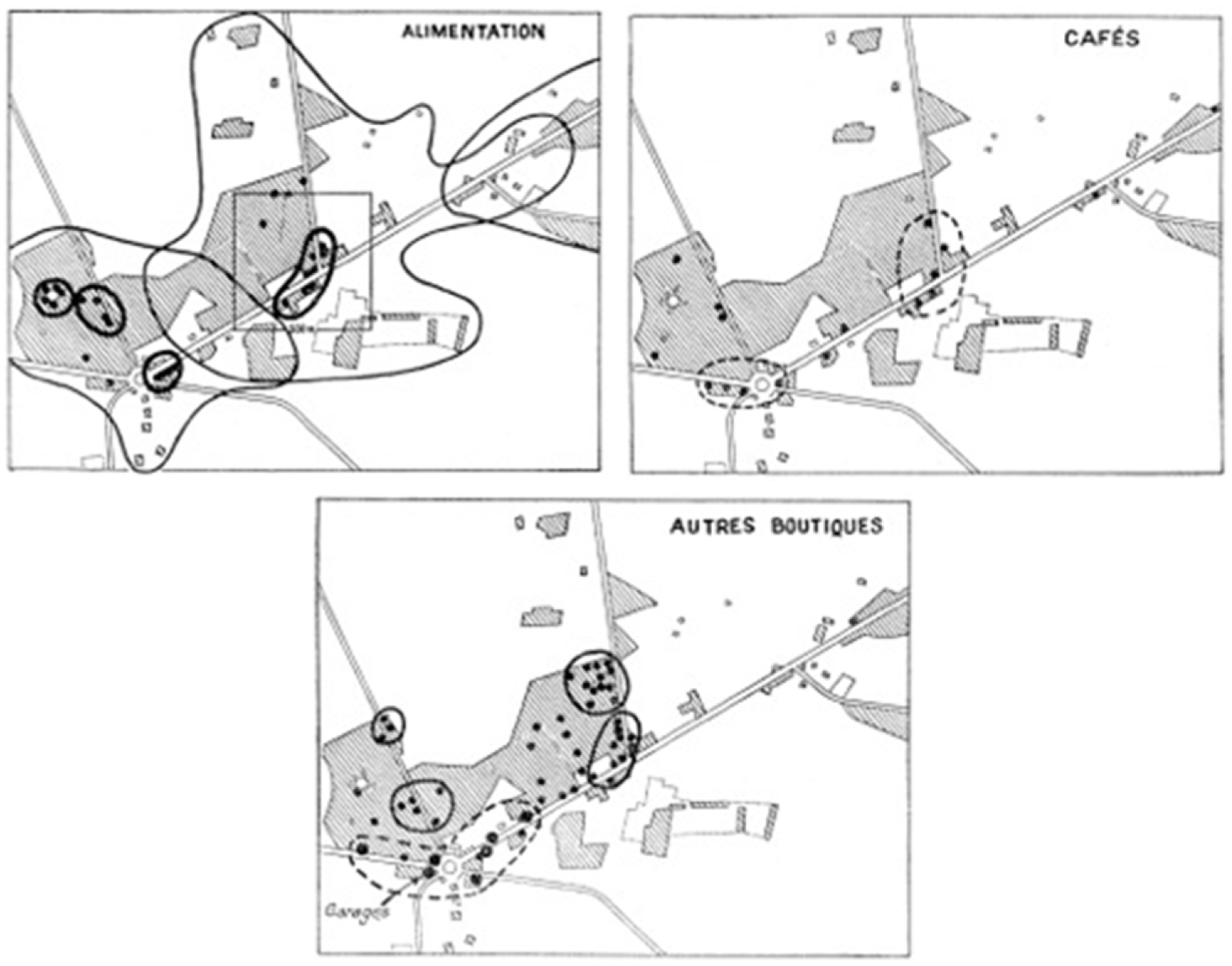
Diagram plotting the distribution and catchment areas of local commerce in Petit-Clamart.
But Chombart did more than just map. He also formulated specific recommendations for the future housing project. He understood this project as a way to create a cohesive community. Therefore, he insisted that the new housing units be made accessible to workers of the same salary level as the existing population. “If not, there will be opposition between two neighborhood groups owing to the social classes present in them.” 75 Another suggestion was to refurbish the infrastructure and roads of the existing allotments so as to diminish the opposition between old and new. The goal of such physical measures was to ensure the social integration of the new development with the existing neighborhoods. In his subsequent design of the housing area, Auzelle attempted to follow these recommendations and claimed to take “the social organization of space” as the basis for planning. Auzelle was a moderate advocate of the Athens Charter but does not seem to have been familiar with the ongoing discussions in the postwar CIAM. He was more directly influenced by the humanist approach of Bardet. Like the proponents of social Catholicism, Bardet and Auzelle were convinced that a small, intimate neighborhood scale offered the ideal framework for personal development and community life and would protect the human spirit against the alienation of metropolitan life.
Auzelle used Bardet’s urban design method of “polyphonic organization.” 76 In practice, this meant Auzelle invited different architects to collaborate. He first asked each of them to produce a master plan and then synthesized these plans using Chombart’s research findings and recommendations. In collaboration with the sociologist, Auzelle chose a neighborhood unit size of thirty to sixty units grouped around a small public space. Apart from a section of individual houses built at the start of the project, the ensemble consisted of collective housing in blocks of four and five stories (Figure 6). The resulting plan was then divided into five sectors that were allotted to the individual architects. This approach was meant to allow modern planning to emulate the diversity of an organically grown, historic city. Auzelle emphasized how this design method and the resulting composition of housing blocks would foster community life. Like other architects at this time, Auzelle thus combined sociological mapping of urban neighborhoods with organic metaphors of nature. 77

Master plan for the Cité de la Plaine by Robert Auzelle, 1950.
The modernist concept of the neighborhood unit—which ultimately shaped many of the housing projects in the French postwar suburbs—was thus supported by a specific vision of community, in large part inspired by sociological mapping of existing urban and suburban working-class neighborhoods. Emphasizing their informal, spontaneous sociability and tightly knit community life, such areas thus became a model rather than a curse. As French planners and sociologists held up community ideals for the grands ensembles, they projected the lifeworld of the nineteenth-century quartier populaire onto suburban developments across the national territory of a rapidly modernizing France.
From Community to the City
During the 1950s, micro-level studies of everyday community life became commonplace in urban sociology. Yet, canonical studies such as Young and Willmott’s Family and Kinship in East London of 1957 signaled the end rather than the beginning of “community” as a sociological concept and planning goal. 78 By this time, several sociologists had already dismissed the idea that the city needed to be limited and delineated by being organized into self-enclosed neighborhood units. 79 The reality of the sprawling metropolitan landscape and the ubiquity of the automobile vindicated such sociological critiques. However, these critiques did more than just note the contradiction between planning theory and urban reality. The waning of the neighborhood unit was part and parcel of the rise of a new type of urban thinking, which, nevertheless, seemed to harken back to strangely familiar concepts. When sociologists and planners during the 1960s asserted that “neighborhood units do not make a city,” they critiqued the concept of community by referring to exactly those characteristics that sociologists such as Tönnies had assigned to the metropolis—Gesellschaft as opposed to Gemeinschaft. Mirroring Jane Jacobs’s 1961 classic The Death and Life of Great American Cities, Hans Paul Bahrdt’s Die moderne Großstadt (The Modern Metropolis) of the same year defended publicness over community, because not neighborhood life but the public and private sphere constituted the basic principles of social experience. 80 Christopher Alexander’s “A City Is Not a Tree,” published a few years later, constituted the death knell of the neighborhood unit and its assumptions. 81 The determinist aspects of human ecology were replaced by cybernetic ideas about the reciprocity of interaction.
This shift was also registered in Glass’s sociological work. By the 1950s, she no longer focused on community as a sociological concept. The Centre for Urban Studies she created at University College London was concerned not with building or researching urban communities but with the problems of transnational migration and urban change—that is, with the city at large. 82 In the introduction to her 1964 edited volume London: Aspects of Change, the concept of community was virtually absent, both as a topic of study and as a theoretical concept informing research methods. 83 Instead of neighborhoods or communities, Glass now talked about “areas of concentration.” 84 The concept of community—with all its underlying sociological assumptions—was inserted into a new discourse, that of citizen participation. Community was now an expression of grassroots activism and protest; it no longer served to guide state-led planning but to fundamentally contest it. This shift also signaled the end of a disciplinary model for European sociology in which research would be directly applicable to planning, policy, or design. Sociological research would now serve to critique the pathologies of modern housing estates and New Towns, for which the state was held responsible.
Footnotes
Acknowledgements
I thank Andrew Harris, Steve Ward, Michael Edwards, John Pendlebury, Peter Larkham, and Michael Hebbert for their help with my search for the records of Ruth Glass. I also thank Prita Meier, Jon Lawrence, and Andrew Harris for their incisive comments on drafts of this article. Finally, I am grateful for the opportunity to present a draft of this article at the conference “(Re)onstructing Communities in Europe, 1918-1968,” organized by Stefan Couperus and Harm Kaal in Nijmegen, The Netherlands, in December 2013.
Declaration of Conflicting Interests
The author declared no potential conflicts of interest with respect to the research, authorship, and/or publication of this article.
Funding
The author disclosed receipt of the following financial support for the research, authorship, and/or publication of this article: The author received financial support from the University of Illinois at Urbana-Champaign for the research on which this article is based.