
Abstract
Before effective drainage and flood protection systems were built in the early twentieth century, areas of inner Melbourne close to the Yarra River were prone to flooding. An overabundance of water and a need to limit its impact on lives, livelihoods, and the built environment drove changes in the engineered structure of a rapidly growing city. Through a case study of a working-class district, we consider how private citizens, drawing on stocks of social capital, responded to major floods in 1863 and 1891. In addition to the process of “top-down” governing, as revealed in public documents, less visible “bottom-up” pressure from local communities played an important role in influencing improvements in water-related infrastructure, such as flood mitigation works. By the turn of the twentieth century, this local pressure increasingly manifested in a centralist approach to water management, whereby metropolitan-wide public authorities took greater charge of local environmental problems.
In the postindustrial era, inner Melbourne, once an area of manufacturing and low-income households, is now home to generally young, well-paid, university-educated, Greens-voting people working in professional services, property, financial, insurance and other business services, retailing, and hospitality. 1 Proximity to the center of Melbourne, access to public transport and bike lanes, and local cafés, restaurants, and boutiques, have driven rising property values for renovated worker cottages, new apartments, and industrial buildings converted into apartments. In the 1960s and 1970s, middle-class residents who moved to the inner city formed action groups to resist further construction of freeways and high-rise public housing. 2 Community concerns around pollution of the Yarra River and its impact on recreational and amenity values arose in the 1960s, and in the twenty-first century, became a critical driver for sustainable urban water management, including water-sensitive urban design. 3
In one inner suburb, Richmond, the desire for water-sensitive urban design was exhibited in a series of “raingardens”—shallow, densely planted basins to retain storm water—constructed in sidewalks along Cremorne Street, close to the Yarra, in 2003-2004. 4 Over a couple of hours, the water percolates down through layers of filter media, which remove contaminants before the water enters the conventional drainage system, and thence the Yarra. This initiative, a collaborative venture between Victoria’s Environment Protection Authority, local government, and an ecologically sensitive landscape architecture firm, involved consultation with the community, which ensured the raingardens were consistent with the values of local residents.
In this article, we consider this expression of suburban water planning in terms of a longer history of local responses to water issues that extends back to the mid-nineteenth century. Solutions to the problem of flooding in this part of Richmond in the second half of the nineteenth century were the product of both “top-down” government action, and the “bottom-up” agitation and involvement of local residents. The ability of nongovernment actors to draw on social capital in addressing urban environmental problems encouraged the formation and evolution of particular relationships with local, colonial, and state governments. This process was central to Melbourne’s early attempts at drainage and flood mitigation from the mid-nineteenth century, and continues to drive sustainable urban water management today.
One such initiative grew out of the flood of the summer of 1863, when Melbourne recorded 5.5 inches of rain—almost 22 percent of the city’s average annual total—in just five days.
5
Rain started falling on the evening of Sunday, December 13, 1863, and by morning, the Richmond Flat was flooded; by afternoon, the Yarra embankment south of the city center had broken. A cold southwest gale restricted the discharge of water into Hobson’s Bay. On the Tuesday, a correspondent later recalled, “with scarcely a moment’s intermission, the rain poured down. The heavy wind blew fiercely. . . . Business was all but suspended.”
6
The city’s gasworks flooded and were shut down, and by midnight,
the city lying in almost total darkness, presented a most doleful aspect, only a twinkling light being visible here and there, and scarcely a sound being heard but the ceaseless patter of the rain, the swash of water as it ran down the channels, and the roar of the river.
7
Almost 3.5 inches fell on the Tuesday and Wednesday. All of this rainfall drained into the Yarra River and its tributaries, many of which had recently become part of the growing city’s footprint. As a result, floodwater that forty years earlier would have spread across a vast undeveloped plain, became an urban disaster, swamping business and residents in low-lying, and mostly poor areas adjacent to the swollen river.
By Thursday, the river resembled a huge lake, with the fast-moving current washing away timber, furniture, and other debris. One Richmond brickmaking firm lost 150,000 bricks in the deluge, another 110,000. A man drowned trying to rescue a table from the river. As the water rushed around a bend of the Yarra in South Richmond, the approaches to a railway bridge were washed away, and floodwaters extended to Swan Street. Near the riverbank at Punt Road, the Sir Henry Barkly Hotel was flooded to the second floor. 8 The level of the Yarra in central Melbourne was more than ten feet higher than normal. 9 By midday on Thursday, the rain had stopped; by nightfall, floodwaters had receded by around two feet.
For years, the 1863 disaster was known as Melbourne’s “great flood.” Subsequent floods, in 1864, 1878, 1880, and 1887, were significant events but caused less damage. Another flood, in the winter of 1891, was not as high as that of 1863 but caused more property damage, as Melbourne was more built-up by that time. About three thousand people living in low-lying areas were left homeless, with many needing their houses to be rebuilt. 10 The Yarra also flooded in 1901 and 1918. In December 1934, the Yarra flooded again, reportedly as high as the 1891 level, after 5.5 inches of rain fell in Melbourne in a forty-eight-hour period. In total, six thousand people were left homeless, and eighteen people drowned. 11 By World War II, the Yarra, widened and straightened, was less prone to flooding, and the problem tended to be confined to local episodes of flash flooding.
A major flood, like an epidemic, is an unpredictable event. But just as the cholera epidemics that struck large cities in the nineteenth century could not have occurred without the overcrowded housing, dirty streets, and polluted water supplies associated with rapid urbanization, the severity of flooding in Melbourne was a product of its drainage and water management technology and infrastructure. The flood-prone parts of Melbourne, as in most cities, were the site of working-class neighborhoods, with more affluent people occupying larger houses on higher and drier ground. 12 In Los Angeles and San Antonio, issues of poor drainage and inadequate sanitation in such neighborhoods tended to be ignored by city governments, due to minority groups lacking effective representation in local government. 13
In studies of disease and flood control, urban and environmental historians have increasingly sought common ground, whereby the city is conceptualized as a hybrid space or an urban ecosystem of natural and built elements. Whether examining nineteenth- and twentieth-century Los Angeles, San Antonio, New Orleans, Manila, or Paris, these historians show the folly of hubristic efforts to divorce cities from nature and to deny the import of hydrological forces on urban spaces. 14 Situating floods in their natural and historical contexts allows historians to show how floods are the product of human and natural factors, how the risk of flooding is differentiated over space and time, and how some groups are rendered more vulnerable to “natural” hazards than others. 15
Reactions to and recovery from such disasters are historically and socially contingent, reflecting governance structures that involve complex sets of relationships between the state and nonstate actors. Michel Foucault defined government as a form of power, or access to resources, that is exercised through calculated attempts by the state to direct the conduct of others to meet particular normative objectives, and the creative responses of locally based individuals and groups. 16 As governments mobilize and coordinate the discourse of “the governed” strategically, through technologies of agency, monitoring, and the deployment of government expertise, new institutional frameworks empower actors at the micro level to negotiate, challenge, and transform policy to influence the distribution of resources. At the local level, the formation of “social capital,” the resource built on preexisting actions that facilitate cooperation and trust between and within groups of otherwise diverse individuals, may foster active participation in collaborative problem solving. 17 Social capital formation at local levels, where site-specific issues and concerns are understood, is positively associated with effective public administration and democratic decision making because it enables efficient and timely flows of information, and develops a sense of shared confidence that otherwise diverse groups can achieve common goals. 18 Through codification, institutional integration, and the deployment of government expertise, the state can act as a bridge between this bottom-up circulation of power, and its assembly to address problems at the macro level. 19 This interpretation rejects the idea that governments “store,” exercise, and consume power through a particular institutional site; rather, power is a relational concept that is distributed, thus taking on the characteristics of a public good, so that any benefits generated are freely available to the broader community.
In the mid-nineteenth century, American sanitary reformers, generally middle-class professionals, lobbied for increased government control over sanitation to offset public health and pollution problems caused by “idleness and drunkenness among the lower classes.”
20
In low-income neighborhoods, and in suburbs where detached houses and large lots prevailed, citizens resisted communal solutions, which were likely to entail increased costs, and clung to the use of private wells, cisterns, and cesspools.
21
The rise of germ theory from the late 1870s, and its broad acceptance by the 1890s, altered understanding of best practice in water technology, and raised household expectations for the provision of public amenities in North American and European cities. The emphasis of sanitary reform was now on changing the “private side” of public health, with individual actions such as improved ventilation, more rigorous bathing and housecleaning, boiling and filtering drinking water, isolating sick members of the household, and the use of chemical disinfectants advocated to address domestic sources of infection.
22
The acquisition and exchange of information among private citizens then influenced the public sector. Economic historians Joel Mokyr and Rebecca Stein observe that
When households acquired the information about what made them sick and what kept them healthy, they often exerted pressure on the authorities to initiate reforms to produce goods that they could not produce for themselves and that the market would not supply.
23
In The Cholera Years, Charles Rosenberg considers the experience of New York City during three major epidemics, in 1832, 1849, and 1866. Rosenberg uses these episodes as a lens through which to observe broader processes of change in nineteenth-century American society. Cholera epidemics were terrifying crises that demanded a response from citizens and their institutions; Rosenberg uses these events as a “sampling technique,” a “randomly recurring stimulus against which the varying reactions of Americans could be judged.” 24 In this article, we adapt Rosenberg’s methodology to compare and contrast community and government responses to floods in Melbourne in 1863 and 1891. Our aim is to identify the process by which Melbourne made a transition from the initial challenge of first providing adequate shelter to a rapidly growing population, through to securing supplies of safe water for those residents, to finally building effective drainage and channelization works to provide flood protection at the turn of the twentieth century. 25 As we show, the key variables in this transition are the responses of private citizens to flood crises and their capacity to articulate shared views, as mediated by stocks of social capital, and the changing governance structures within which the public goods of flood relief and management were provided.
Building the Suburban City: The Richmond Flat
While the Yarra itself is only 145 miles in length, its catchment south of the Great Dividing Range extends to around two thousand square miles. Along its course, large floodplains and billabongs (oxbow lakes) hold water after heavy rain and snowmelt; closer to Melbourne, the river snakes around natural obstacles before reaching an area of flat, naturally swampy ground at the Yarra-Maribyrnong delta, before its outlet at Hobson’s Bay. The town of Melbourne was laid out in 1837 on an area of slightly elevated ground about ten miles up the river, where rocks separated fresh water from salt. Narrow, shallow, silt-filled, rocky in places, and choked with tree trunks and branches, the Yarra was naturally prone to flooding. The first white people to see the Yarra, a party led by the acting surveyor-general of New South Wales, Charles Grimes, explored around twenty miles of the river in 1803. Past the area of flat ground where the suburb of Richmond would be built, James Flemming observed debris from flooding in the trees “eight or ten feet at times” above the river level. 26 In 1839, the Yarra rose by more than ten feet near the center of Melbourne, flooding Flinders Street and the “Flats” of Collingwood and Richmond. There were further floods in 1842 (twice), 1844, 1848, and 1849. 27
After gold was discovered in Victoria in 1851, Melbourne’s population of twenty-nine thousand increased by 33 percent each year in the subsequent decade, to 125,000. 28 At the peak of the gold rushes in 1852-1853, the colonial government responded to Melbourne’s housing shortages by exempting land outside the central grid from the Melbourne Building Act of 1849, which mandated fireproof construction and minimum street widths. The Melbourne Corporation (later the Melbourne City Council), established in 1842, lacked the funds to provide infrastructure for the town, and no attempt was made to annex new areas of building activity beyond the city boundaries. 29 To the east, affluent suburbanites built mansions, villas, and terraces on a picturesque hill at Richmond. From the hill, an area of heavy clay running down to the Yarra River, known initially as the “Richmond Swamp,” was first sold in 1838, in portions of around twenty-five acres. 30 The flat land extended north of Richmond to Collingwood, a suburb “crippled from birth” by its topography, heavy soil, and proximity to the Yarra. 31
Local artisans and small business owners formed the East Collingwood Local Committee in 1853, seeking mutual gains by petitioning the colonial government to improve roads and drainage in the area. 32 Along with similar groups in other parts of Melbourne, the East Collingwood committee held public meetings and presented petitions to the colonial government to allow the incorporation of new municipalities. The creation of incorporated municipalities in 1855 in Prahran, St. Kilda, Emerald Hill, East Collingwood (the “East” prefix was later dropped), and Richmond is evidence of high levels of civic engagement and a sense of shared responsibility at local levels throughout Melbourne, as municipal incorporation was conditional on the circulation and signing of petitions by residents.
Richmond’s South Ward—the area between Swan Street, Richmond’s most prestigious shopping strip, and the Yarra River, extending from Punt Road east to Burnley (Figure 1)—developed into a heavily industrialized area, with worker housing that was increasingly neglected over time. Flat land close to the river was a magnet for industries that needed water for steam engines and processing, and a ready means of waste disposal. These industries included foundries, timber yards, flour and sawmills, breweries, slaughter yards, tanneries, and soap and candle works. Although houses may be expected to deteriorate over a long period due to normal wear and the obsolescence of fittings, Richmond’s housing stock was in many ways defective from the outset. As the suburb’s southern boundary, the Yarra served as a common resource that the owners of noxious industries used as a sewer. On the other side of the Yarra, in the City of Prahran, parts of the hilly land were swampy and vulnerable to flooding. But most of the land south of the Yarra rises steeply, and when the river rose, there was nowhere for the water to go but onto the Richmond Flat.
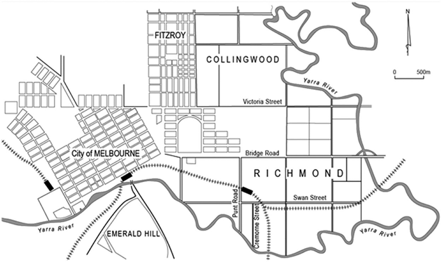
Richmond and Surrounding Municipalities.
The section of South Ward between Punt Road and Church Street was called Cremorne, named after the nearby Cremorne Gardens, a park by the Yarra with a bandstand and maze, built in 1853 by James Ellis, a confectioner who had established a park of the same name in Chelsea, London, eight years earlier. A Melbourne entrepreneur, George Coppin, bought Cremorne Gardens in 1856, and developed them into a nighttime “scene of enchantment,” with theaters, hotels, and sideshows. 33 After Coppin became insolvent in 1863, the site was sold to the owner of a private mental asylum.
Cremorne’s major street, Cremorne Street, runs south from Swan Street, near the Richmond railway station, for about one-third of a mile to the Yarra River. The first houses in the street were built in the 1860s or earlier, offering low-rent housing to clerks, artisans, factory workers, and unskilled laborers within walking distance of the city and local workplaces. These three- or four-roomed timber cottages had frontages of around sixteen feet and were typically built on lots of around twenty-two to twenty-four feet in width, and about 130 feet in depth. A lane at the rear allowed the emptying of cesspits (and later pan, or pail toilets). 34 These narrow, single-family, single-story dwellings resembled the “shotgun” houses of New Orleans, with the Melbourne variation being a hallway leading past the sitting room and bedrooms to the kitchen. 35 As in New Orleans, no worker houses had bathrooms or inside taps. Melbourne houses were built without cellars, and it is likely that most from this era were built without proper foundations.
One-third of a large sample of old, substandard dwellings in Richmond in 1937, most of which dated from the 1860s, were found to have been built with floors on or level with the ground. In sum, 77 percent had unsound floors. 36 Families were typically large—five, six, or seven children was the norm—and all rooms except the kitchen were used for sleeping. A police constable based in Richmond told a 1917 Royal Commission into housing in Melbourne, “There are a lot of poor people in Richmond, who cannot afford to pay big rents for houses; although they may be habitable, they are wretchedly small and inconvenient in every way.” 37 Conditions outside the house made it difficult for women to keep their houses clean. Storm water and seepage from cesspits ran along open drains from higher ground and through street gutters to the river. The flow of polluted water was checked by blocked drains and unmade streets. Richmond City Council did not begin improving roads until 1901, when Swan Street was paved with wood blocks. In 1902, 210 Richmond streets had no nameplates.
Yet at a time of housing scarcity—almost one-third of Victoria’s population in 1861 lived in impermanent housing, such as tents and shanties—such cottages in Richmond’s South Ward offered more than adequate accommodation and space by the standards of the day, less than a decade after the gold rush. 38 Elevated, well-drained land close to the center of Melbourne was already occupied by the grand homesteads and suburban villas of the professional and merchant elite. More distant suburbs south of the Yarra were accessible by railways but remained semirural and largely undeveloped. 39 Flat land near the river was at a premium, and the unplanned subdivision and residential crowding that developed there created lasting problems for the city.
Melbourne’s population had increased to 268,000 by 1881, and nearly doubled to 473,000 in the subsequent decade. A boom in land purchase and house building was fueled by the reorganization and expansion of the city’s finance, commercial, communications, and public administration sectors, successful city investment in mining and pastoral activity, increased rates of in-migration, and the marriage and homemaking of the children of the gold rush generation. In all, 70 percent of this population growth was absorbed by new, largely middle-class suburbs built on sloping and seaside areas to Melbourne’s south and east, and flatter, working-class suburbs to the north and west. 40 Railway extensions, built and operated by the colonial government, encouraged large investors to subdivide farmland into new estates, and small investors to buy individual house lots to sell on to builders. This was a high-risk strategy, although it offered high returns: it was usually financed on credit in the expectation of continuing future demand. In 1887, the average net rate of return on land investment in Melbourne was 78 percent per annum, and the average mortgage for land purchase was paid off in less than twenty months. 41 By the early 1890s, land values had collapsed, and many borrowers defaulted when it became clear that they could only sell their land at a loss.
The City of Richmond’s population rose from twenty-three thousand to almost thirty-nine thousand during the 1880s. In Cremorne, the remaining land running south to the Yarra (the former site of Cremorne Gardens) was subdivided in 1885, when 282 lots, with eighteen-foot frontages, were offered for sale by auction by Thomas Bent and his partner J. S. Vickery, the first of many land purchases and subdivisions they undertook. 42 The existing streets were extended to the river, with new cross streets created. “Buyers at the Sale Will Double Their Money,” an advertisement in the Richmond Guardian claimed. 43 A sale poster emphasized the accessibility of the land: “Richmond station, when the progressing works are completed, will be the most important station in the colony, and every foot of land in its vicinity will be eagerly sought for.” Another declared, “Every lot has good drainage,” presumably based on the downwards slope of the land towards the Yarra, but ignoring the possibility of rising waters from the river. 44 A large marquee was erected for the auctions, which drew a crowd that the Richmond Guardian estimated at two thousand, “the Hon. T. Bent being in close proximity and directing the details of the sale.” 45 After four hours of selling, 167 lots were sold.
The oldest part of Cremorne Street, at the northern end intersecting Swan Street, was fully built up by 1891. Municipal rate-book entries for that year show that of the first fifty houses on the eastern side of Cremorne Street, twelve were owner-occupied (24 percent). 46 This is a very low rate of owner-occupation, below the estimated figure for Collingwood in that year (34 percent), and well short of the figures for newer working-class suburbs (43 percent). 47 However, owning property for rental was a significant source of wealth creation for people who lived in Richmond. Of the thirty-eight tenanted houses in the sample, twenty-eight were owned by landlords who lived locally. Ten houses were owned by three landlords who lived in the sample section. Of the forty-six occupied houses, only four were occupied by people working in clean-handed occupations—a journalist, a clerk, a bookseller, and a “gent.” Two brothers, John and William Sutherland, lived and worked at the vinegar factory that their father had opened in 1885. 48 The other houses in the sample were occupied by workers in unskilled manual occupations, and a small number of skilled manual workers (one builder, one carpenter, and three painters). Seven women occupied houses (one as an owner); of those whose occupation was listed, one was a laundress, one a charwoman, and two ran boarding houses.
“Unprecedented Violence”: The Flood of 1863 49
The Richmond community responded quickly to the flood of December 1863, pulling together to support each other, providing immediate aid, and establishing relief funds. A public meeting to identify appropriate action was called by the Richmond mayor, and advertised in local newspapers. A local newspaper described the “loss of property and . . . deprivations” suffered by the “poorer inhabitants” of Richmond as being “more severely felt than in any one of the suburbs where the fury of the rushing water has been felt.” 50 Five days after flooding began, residents met in the Richmond Courthouse to discuss the establishment of a relief fund for flood victims in the lower areas of Richmond. The Richmond City Council had earlier voted to contribute £50 toward flood relief. 51 Residents supported this action, and those at the meeting agreed to support the council making further grants.
A seven-person collection committee was appointed, “with power to add to their number.” The suburb was divided into six sections, and in each, “twelve working committeemen be appointed to collect subscriptions from house to house.” 52 Donations of furniture and household items were also to be accepted. 53 A separate distribution committee was appointed, comprising the mayor, counselors, and clergymen. Funds were to be directed to those who “were in urgent distress” rather than to those simply seeking compensation for losses in the flood. Many of the latter were described as having sufficient resources to “bear their loss,” whereas most victims of the flood were the poor, living on the lowest-lying land. To promote the fund, residents called on local clergy to raise the issue with their congregations, and asked publicans to open subscription lists in hotels, an alliance that was described as unusual but effective in reaching those in need.
These initial responses were grassroots social movements, shaped by norms of generalized reciprocity, the principle Putnam refers to as “the touchstone of social capital.” 54 The willingness of people not directly flood-affected to support those who were was built on trust based on preexisting networks of social exchange. All locals were expected to contribute what they could to relief funds, even the poor. One speaker at the residents’ meeting commented that “the flood was caused by a multitude of drops of rain,” implying that drops of money could similarly create a flood of resources to help the community. “Poorer classes of the inhabitants of the district would do well to remember that their subscriptions, even if only 1s. [one shilling] each, might be of great use in rescuing a number of their neighbours from destitution.” 55 A more broadly based general relief fund was also established in Melbourne at a meeting on December 31, 1863, at the Melbourne Mechanics’ Institute, convened by the Melbourne mayor. 56 The distribution committee included the Richmond mayor and his counterparts in other flood-affected municipalities, who, as civic leaders, were thought to be best placed to recommend which residents should receive financial aid.
After the flood had subsided and the immediate crisis had passed, the local community, and that of Melbourne more generally, called on the colonial government to undertake flood mitigation works on the Yarra River. The response at the government level was shaped by fragmented and uncertain institutional arrangements. All Crown lands were vested in a Board of Land and Works, established by the colonial government in 1857, which had statutory responsibility for the construction and maintenance of public buildings, roads, bridges, railways, water supply, sewers, and drains. Subdepartments existed for those functions, some with responsible ministers, but all were subject to the control of the board. The board and its subdepartments did not take direct responsibility for all of these activities, and distributed grants to municipal councils, which did not have borrowing powers, for road building and drainage. 57
In response to the 1863 flood, the colonial government appointed a Board of Inquiry, composed of the inspector-general of public works, the engineer-in-chief of railways, and the inspector-general of roads and bridges. The Argus attributed the severity of the floods to “the obstructions we have built up against its (the Yarra’s) free course to the sea.” 58 This view summarized the board’s approach to the problem and shaped its recommendations for flood protection works. In August 1864, the Board of Inquiry recommended widening and deepening the Yarra, constructing embankments, and diverting the course of the river and cutting a channel three hundred feet wide from the south bank of the Yarra through to Hobson’s Bay. Such a channel would discharge floodwater and provide increased wharf space closer to the city. 59
The board was driven by utilitarian objectives, to protect the city from flooding, but its concern to “discharge the flood waters without interfering with the regimen of the river in its ordinary state, or withdrawing any portion of the water which is required for the preservation of the outfall” suggests that attention was also paid to environmental issues. 60 Some parliamentarians questioned any colonial government involvement, suggesting that the responsibility for flood control and repair “should be in the hands of the Melbourne Corporation and suburban boroughs.” 61 Others argued against drastic action, suggesting, “It was not likely that there would be a recurrence of such a disaster for some time to come.” 62 A lack of consensus over these issues delayed action, and the board’s recommendations were not implemented.
A decade later, in 1873, the Yarra’s potential for flooding came under the review of the Low Lands Commission, appointed by the colonial government to inquire as to the best use of the poorly drained areas to the west and south of the City of Melbourne. 63 The commission had been tasked with determining the lands that ought to be “withheld from sale or occupation” for the Port of Melbourne, and for “rapidly carrying off flood-water from the Yarra.” 64 Despite these instructions, the commission’s recommendations offered little in the way of alleviating the flood risk, instead, advising the cutting of drains through swampland and the construction of a ship canal “for vessels of large tonnage.” Commissioner Thomas James Sturt, a doctor of medicine who lectured at the University of Melbourne, declined to sign the final report, claiming that neither the canal nor the embankments would prevent flooding in the future. 65
Despite repeated flooding of the Yarra, the issue of flood prevention remained overshadowed by ongoing debates about the inadequacies of Melbourne harbor and the facilities available for shipping. In 1877, the Melbourne Harbour Trust was formed in an effort to resolve these tensions, and, the following year, the Trust appointed the veteran English civil engineer, Sir John Coode, to advise on the port’s improvement. Historians Tony Dingle and Andrew May argue that Coode’s subsequent report “was a catalyst for major flood mitigation schemes and harbour extensions.” 66 Coode’s visit to Melbourne coincided with the flood of March 1878, reported to be, “One of the heaviest and most disastrous floods that has ever occurred in the Yarra since Melbourne was founded.” 67 In the aftermath, Coode echoed the 1864 Board of Inquiry report, advising the widening and deepening of the Yarra, as well as smoothing the “sharp and inconvenient curve known as Fisherman’s Bend” via a channel from its junction with the Maribyrnong River. 68 Digging of this channel started in 1880 as a means of providing relief for unemployed workers. Other measures included dredging and the removal of reefs from the Yarra south of the city grid. 69 Water from the Yarra was let into the new Fishermen’s Bend Cut in 1886, and the canal was officially named Coode Canal in 1899. 70
“Extraordinary Magnitude”: The Flood of 1891 71
Five years later, the flood of July 1891 put these interventions to the test, and they were found wanting. The flood was “wholly unexpected” because observers expected that these interventions would ensure that “no further inundations need be feared in the Yarra.” 72 Local newspapers described the “extraordinary magnitude” of the flood, the “remarkable rainfall,” the “boisterous and inclement” storms, and the hundreds of people who had to “fly for their lives.” 73 According to the Age, Richmond yet again felt the effects of the flood “more severely . . . than in any other suburb.” Floodwaters inundated the factories on the banks of the Yarra, while “whole streets of houses have had to be vacated, and in many instances the inmates experienced narrow escapes from being drowned.” 74
In the days immediately after, there were calls for action at a civic level on both sides of the Yarra to reduce the impact of future floods. Although Richmond’s flooding woes were far from resolved, the community played a less active role in the search for a solution than they had in 1863. Changes in the socioeconomic composition of Richmond are likely to have reduced the frequency of formal and informal interaction between residents, which limited the formation of social capital. The housing stock of the suburb had also aged and decayed since the 1863 flood, and the rate of owner-occupation was low, which may have diminished the commitment of residents to the welfare of their neighbors and the suburb as a whole.
After the 1891 flood, Australia was affected by a depression that hit Melbourne harder than any other capital city. An estimated 28 percent of Victorian trade unionists were out of work by the end of 1893, with Richmond’s building trades and consumer goods manufacturers especially sensitive to reductions in consumer income. 75 These conditions also reduced demand for local housing and increased the rate of residential turnover in the suburb. In our sample of fifty houses in Cremorne Street, twenty-four of the thirty-five tenants (69 percent) who occupied houses in 1892 were living at the same address in 1893. By the following year, the number of 1892 tenants remaining had fallen to nine (26 percent), and thirteen houses stood vacant. 76 Between 1891 and 1901, Richmond experienced a net loss of more than a thousand inhabitants, a decrease in population of 2.25 percent.
Furthermore, the knowledge that germs, rather than miasmas, were the cause of disease had by 1891 encouraged municipalities to consider metropolitan-based solutions to problems of sewerage and drainage. The creation of the Melbourne and Metropolitan Board of Works (MMBW) in 1891 established a new form of top-down authority that had been absent in 1863. The fragmentation of local government across Melbourne made it difficult for councils to coordinate public works across municipal boundaries. The unwillingness of local councils to support the establishment of an authority along the lines of London’s Metropolitan Board of Works (created in 1855) also delayed sanitary improvements. 77
Open drains running from the City of Melbourne polluted the Yarra, and created nuisances in the inner suburbs. Local councils in Richmond and Collingwood resisted paying for a sewerage system because their representatives considered it likely to result in increases in taxation, which would discourage local industry. Meanwhile, outer suburban councils also dismissed the need for a sewerage system, as miasma theory promised that their elevation combined with sea breezes, large housing lots, and backyard cesspits would protect them from disease. By 1888, however, growing concern about Melbourne’s vulnerability to epidemics of typhoid and other waterborne diseases, and greater medical acceptance of germ theory pointed to the need to construct a sewerage system that would serve the entire metropolitan area. A Royal Commission recommended that a statutory body, comprising representatives of all municipal councils, be created to build a sewerage system and operate the city’s water supply. 78
The MMBW would provide engineering expertise to issues of flood control, as well as sewerage and water supply. The creation of the MMBW reflected the growing prevalence of a technocratic approach to disaster prevention. As this approach fosters the concentration of scientific expertise in government bureaucracy, concern about the preparedness, prediction, and control of natural hazards is abrogated to specialists. This process, according to geographer Kenneth Hewitt, “quarantines disaster in thought as well as in practice,” which, in turn, places the responsibility to ameliorate disaster squarely on the government. 79
Much of the contemporary debate about the appropriate response to the flood problem centered on government responsibilities. In Prahran, construction of an embankment on the south side of the Yarra, and a survey of the water levels to ascertain the limits of the floodwaters, were suggested. 80 In Richmond, the Council regarded flooding as a metropolitan rather than local issue, and called on the colonial government “to take steps to prevent a recurrence of the recent floods.” 81 At a relief meeting called by the Richmond mayor, a counselor suggested that no more houses be built below the flood line and that works be undertaken to widen the Yarra River “right up to Richmond.” 82 A week later, a reporter in the Richmond Australian called for the removal of reefs upstream of Princes Bridge and the construction of dams or levees. 83 However, the writer acknowledged that private ownership of the riverbanks was an obstacle to building levees, raising the possibility of excessive demands for compensation.
In August 1891, the Victorian government established the Yarra Flood Prevention Board to investigate the cause and extent of the floods, the extent to which “they are contributed to or intensified by artificial or preventable causes,” and “the best means for preventing floods on the Yarra.” 84 Among the members were the inspector-general of Public Works, the engineer-in-chief to the MMBW, and the acting chief engineer of the Melbourne Harbour Trust, as well as the municipal surveyors of Melbourne’s eight riverside municipalities. The board’s 1892 report suggested that Coode’s flood mitigation strategies had been unsuccessful, which was attributed to a paucity of reliable streamflow and flood data. As a consequence, “[W]hilst the carrying out in their entireness of Sir John Coode’s recommendations would give some relief to sufferers from floods in South Melbourne, no benefit would be derived therefrom in Richmond and Prahran.” 85 The Board recommended a suite of works, including widening the Yarra, as recommended in 1864, and removing snags from the river. The board also called for the definition of flood-prone lands where further house construction would be prohibited and existing property owners warned of the risk of flooding. 86
But there was disagreement among the board members. Some municipal surveyors and engineers argued that these strategies would do little to alleviate flooding beyond the lower Yarra, in areas such as Richmond: “The tides in Hobson’s Bay do not, as popularly supposed, influence the river floods so far as these districts.” 87 Although the board advocated the completion of Coode’s recommendations relating to the deepening and widening of the river, it also counseled caution for further interventions, “drawing attention to the long intervals at which [floods] occur, only five having been recorded during the 57 years of the colony’s history.” 88
Three years of public meetings ensued, in which the costs and benefits of different flood mitigation strategies, and the responsibility for undertaking these strategies were discussed. The Richmond City Council called for a “straight cut from the Yarra opposite the Gas Works for the prevention of Yarra floods,” and later joined with representatives of other municipalities to discuss improvements to the Yarra. 89 Richmond residents dismissed the suggestion that building should be avoided on flood-prone land as many locals could only afford property in those particular areas. The local preference was for the Yarra to be widened and deepened, which residents argued would increase local property values and provide local employment during the winter. 90
The eventual passage of the Yarra Improvement Act in 1896 represented a wider recognition that the reduction of flood damage required specific attention. 91 The Act focused on the area between the east side of Prince’s Bridge (at the city center) and the Church Street Bridge, where measures would be undertaken to widen and deepen the river, and to form embankments on either side. The colonial government agreed to provide funds for the work, on the basis of £2 for every £1 from the City of Melbourne, the City of Richmond, the City of Prahran, and the Yarra Floods Relief Fund. This would provide employment in a depressed economy. 92 However, council engineers from Richmond and Prahran could not agree as to the specific works to be undertaken, or whether those works would increase the likelihood of flooding further down the river. In 1900, the mayor of Richmond complained that there were insufficient funds to extend the improvements as far as the Church Street Bridge. 93 The following year, heavy rain caused the “waters of the Yarra to become as swollen as they were in 1891.” Despite fears of flooding, the mayor reported that “the improvements effected to the river from Punt Road westward, to which this municipality contributed £4,000, proved sufficient to keep the waters within the river banks.” 94
The “inestimable value” of the Yarra improvements was demonstrated when the river again broke its banks, in September 1916. 95 The Richmond Australian reported that, “[H]ad it not been for the Yarra improvement carried out in the lower Yarra the flood would have undoubtedly been a record one in Richmond.” 96 According to the newspaper, the widening and straightening of the river had allowed the floodwaters to flush away quickly, averting the flooding of adjacent suburbs.
Conclusion
Floods during and after World War I continued to prompt public debate about the city’s drainage system and management of the Yarra. 97 In 1923, the Victorian government passed the Metropolitan Drainage and Rivers Act, which gave the MMBW control “of all the rivers and streams in the metropolis” that flowed through two or more municipal districts, and empowered it to construct and maintain drains, and carry out river improvement works. 98 The MMBW’s flood mitigation measures on the Yarra included cutting a large channel through disused quarries in Richmond (the “Quarry Cut”), just east of the Church Street bridge, and dredging and widening the Yarra and Maribyrnong rivers. 99 These works were no match for the flood of early December 1934, which transformed the Yarra into a “series of vast lakes connected by swirling rapids” that spread from Melbourne more than forty miles along the Yarra Valley. 100 Newspapers reported that the Yarra had reached a “record height,” taking the lives of at least seventeen people, and leaving as many as five thousand people homeless or flood-affected across Victoria. 101 Among the homeless were some three hundred residents of Richmond, where more than a hundred acres of the suburb had been submerged, and fifty homes were inundated. 102
Although the Yarra would flood again after World War II, none rivaled the floods of 1863, 1891, or 1934. The flood mitigation works that preceded the 1934 disaster were shaped by the increasingly central role played by the state government in managing Melbourne’s rivers and their surrounds. Vital to this shift was the establishment of the MMBW in 1891, a unifying public authority for the planning and construction of sewerage and water supply, with jurisdiction across municipal boundaries. The public response to the 1891 flood was more muted than had been the case in 1863, which was the product of the effects of deteriorating economic conditions on community stability, and levels of social capital in what were by then disadvantaged neighborhoods. An increasing reliance on top-down solutions to flood risk reflected an abrogation of civic responsibility to an increasingly centralized government authority. By World War II, responsibility for addressing issues of flood control had entirely passed into state hands, in the form of MMBW engineers and planners. After the 1934 flood, citizens made donations to a State Relief Fund and a Lord Mayor’s Fund, and offered to house the homeless, but local input into flood mitigation initiatives was now absent. 103
During the nineteenth century, social capital had been an important driver of drainage and flood control measures in urban Victoria. The community response to flooding was strongest after the 1863 flood, when Melbourne’s infrastructure was relatively primitive. During and immediately after the flood, residents drew on social capital to cope, with the broader community assisting those directly affected. Local government, and in turn the colonial government, was called on to address the issue and to limit the impact of future flooding events. Historical difficulties of conflicting expert and political opinions, optimism that the most recent flood could never be exceeded, governance structures in which responsibility for flood mitigation was unclear, and limited financial resources were resolved, in response to calls from both levels of government and the community, by the establishment of the MMBW. The MMBW was able to collect much-needed rainfall data on which to plan the design of drainage and flood control systems, if imperfectly. These systems have largely succeeded in restricting the flooding of Melbourne, although occasional flash flooding still occurs in the low-lying areas of the city after extreme rainfall events.
From the 1960s, popular concern around pollution of the Yarra River and its implications for local recreational and amenity values developed to become a critical driver for sustainable urban water management, including water-sensitive urban design. Social capital has been a key factor in Melbourne’s transition toward sustainable storm-water management since the colonial era. This study of the civic and civil responses to flooding in Richmond through the nineteenth century suggests that such social capital has been an important characteristic in the urban environmental history of colonial Melbourne. Local action demanded early work on the Yarra River to provide drainage and mitigate flooding, and continues to influence the progress toward sustainable urban water management in the twenty-first century.
Footnotes
Acknowledgements
Thanks to Robert Ousley of the Richmond and Burnley Historical Society, Kara Rasmanis for drawing the maps, Pete Minard for research assistance, and Peter Breen, Sara Lloyd, and Joanna Thompson for information.
Declaration of Conflicting Interests
The authors declared no potential conflicts of interest with respect to the research, authorship, and/or publication of this article.
Funding
The authors disclosed receipt of the following financial support for the research, authorship, and/or publication of this article: This study was supported by the Cooperative Research Centre for Water Sensitive Cities and the Australian Research Council (DE160101125).