
Abstract
This article discusses the urban spaces of the pseudo-colonial city via the urban transformation in the eastern area of Bangkok between 1855 and 1932. During this period, the Thai royal government was under pressure from colonialism in the Southeast Asian region. To prevent colonization of the country, the kings aimed to strengthen their economic and political powers through administrative reform, educational development, infrastructure construction, and land commodification Thus, the urban spaces in Bangkok were significantly transformed. The eastern area became a transitional zone between the administrative center of the royal government and the commercial center where foreign traders resided. Furthermore, this transitional zone continued expanding into the area of rural communities, and, consequently, the traditional settlements of the local people gradually lost population.
Introduction
The Thai-imperialism period (1855-1932) is considered a paradigm shift of Thai society. In 1855, the Siamese Kingdom and the British Empire signed the Bowring Treaty, which caused the Siamese royal government to lose its monopoly on economic power in the kingdom while Western countries received extraterritorial rights. This power shift resulted in King Rama IV (1851-1868) viewing diplomatic policy as an important instrument to maintain the sovereignty of Siam and prevent it from being colonized. In the following reign of King Rama V (1869-1910), the Thai monarch tried to represent himself as another colonizing power within the Southeast Asian Region by centralizing his administrative power in relation to his tributary states while modernizing the image of his kingdom so it would be viewed as a civilized country. 1
As a result of changing political and economic policies, as well as influence from Western countries, Siam was able to remain politically independent from Western colonizers. However, Siam’s national economy was still influenced by Western nations, and Bangkok became a favorable destination among foreign traders as a free-trade market. There are several terms that can be used to describe the status of Siam during this period: a semi-colony, pseudo-colony, internal-colony, and crypto-colony. 2 However, a pseudo-colony is considered the most appropriate term to clearly define the political status of Siam for the purpose of this research.
Another major strategic goal of the Siamese monarchs during this period was to increase the capacities of farm production and trade. The kings approved several development projects based around transportation and irrigation systems, which had significant impacts on the physical transformation of the rural, eastern area of Bangkok. This development included the areas of Pathumwan, Bang Kapi Field, Prakhanong, and Bang Chak becoming suburban residential zones of Siamese nobles and foreign residents (Figure 1). 3 As a result of this increased development, the area east of Bangkok became a strategic transfer zone between inner areas of Bangkok and the port city of Samutprakarn. This allows us to see the eastern area of Bangkok as the urban representation of the pseudo-colonial city of Bangkok during the Thai-imperialism period.

Map of the eastern area of Bangkok.
To identify and understand the urban spatial change of eastern Bangkok, information was collected from primary sources, including public documents, government correspondences, urban policies and regulations, newspapers, magazines, and photographs, as well as secondary sources such as academic research and other publications from associated agencies. These archives can be found in the National Libraries and the National Archives of Thailand.
The Urban Character of the Colonial City in the Southeast Asian Region
Before eastern Bangkok can be defined as part of a pseudo-colonial city, however, it is necessary to review the literature about the urban character of Southeast Asian colonial cities. According to O’Connor, Southeast Asian cities were originally formed by a concentration of manpower through common religious beliefs and economic requirements. 4 These traditional cities were dominated by monarchies, the members of which lived in a grand royal palace located in the core city area. The cities were also surrounded by diverse and unplanned expansions of settlements. Each settlement group was administrated by aristocrats whose compounds were connected to the royal palace. 5
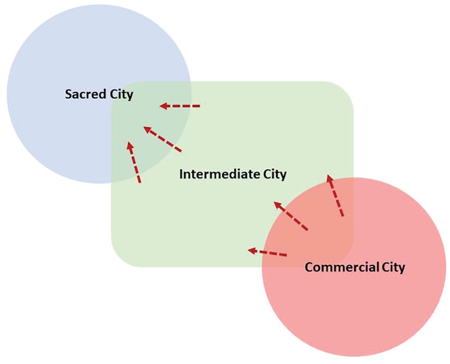
According to Evers and Korff, Southeast Asian cities were fundamentally composed of three main urban patterns: commercial cities, sacred cities, and small intermediate cities. The commercial city was a zone of multiple ethnic communities and was usually located in waterside areas where trading activities occurred. The sacred city was the center of traditional administrative and religious power. The area was dominated by the royal family who monopolized the agricultural production of the kingdom. Meanwhile, the military influenced the administrative power in the sacred city. Finally, the small intermediate city was an area of inland communities where farming activities took place. 6
Colonialism is centered on the goal of appropriating resources and manpower that belong to Indigenous peoples as a part of the production process of the colonizing country. This is accomplished by introducing a capitalist economy into the colonized society. 7 In the case of Southeast Asian cities, Western colonizers attempted to take over land possession rights and the monopolistic trading powers of the traditional rulers by forming new administrative centers in the commercial cities and by constructing modern infrastructure, administrative offices, military bases, and other facility buildings. 8 In addition, a segregation policy was often implemented by the colonizers to limit the economic opportunities of non-Western residents, who were also being colonized. This was especially the case for Chinese residents. The colonizers provided Western education to local people to reduce the class distinctions among them. 9 The transformation of Southeast Asian urban society during the colonial period is reflected in the urban spatial pattern shown in Figure 2; the zoning of the commercial city was expanded into the area of the small intermediate city, while the sacred city gradually lost its value.
Urban pattern model of colonial cities in Southeast Asia in the colonial period.
Unlike other Southeast Asian countries, Siam was not colonized; instead, it was considered a pseudo-colonial state. According to Jackson in 2010, the distinction between pseudo-colonial and colonial states is determined by the relationship between the colonized and the colonizers. Although the pseudo-colonial country had its political independence, its socio-economic pattern was similar to other colonized countries in the same region. The Siamese king attempted to represent himself as a local colonizer by applying the colonial method of Westerners to centralize his administrative power over the tributary states. However, Siam received heavy economic pressure from Western colonizers to open a free-trade market within Southeast Asia. 10
Bangkok Before the Thai-Imperialism Period
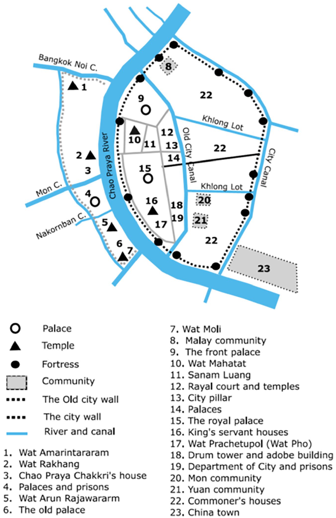
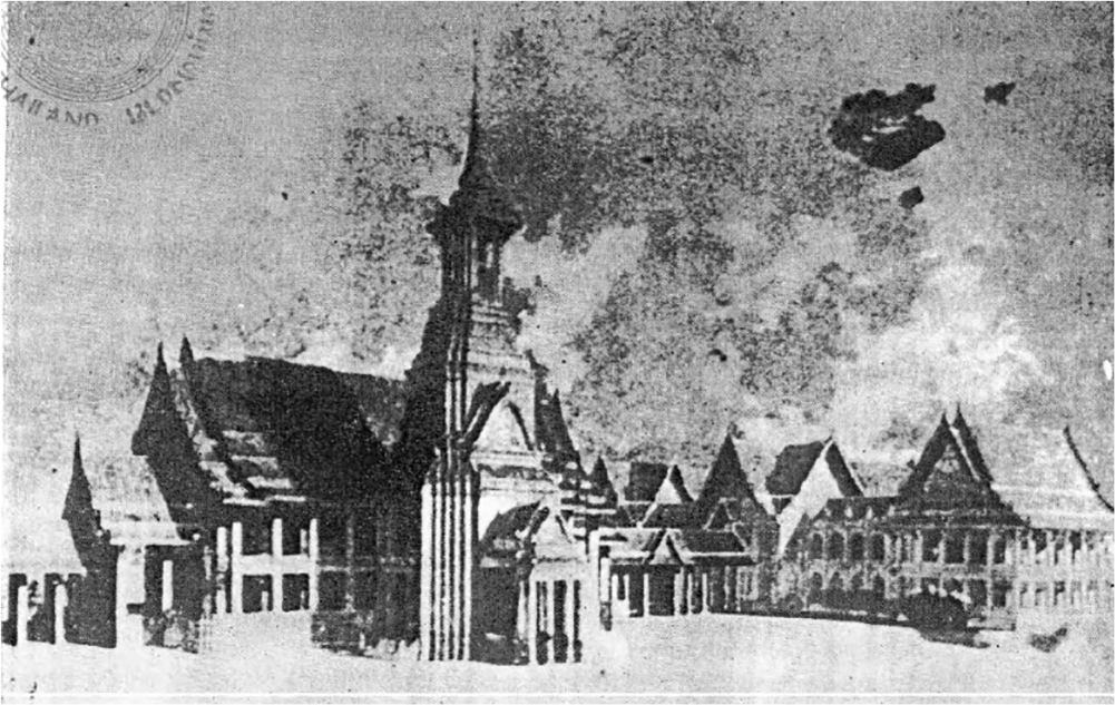
Before outlining the urban character of Bangkok as the capital city of a pseudo-colonial state, this section of the article discusses the city’s origin and development in the 600 years before the Thai-imperialism period. During the period of Ayutthaya Kingdom (1352-1767), the area, especially on the eastern side of the Chao Praya River, was a settlement of Chinese merchants. After the fall of the kingdom, a new capital city, Thonburi, was built on the western side of the river. By 1782, King Rama I (1782-1809) established the Rattanakosin Kingdom (the kingdom of Thailand prior to the Siamese Revolution in 1932) on the eastern riverbank after the death of King Taksin, who was the only king of Thonburi. 11 Consequently, the old Chinese communities were moved from the eastern riverbank to the southern riverbank. This new location of settlements later became a major trading zone of Bangkok called Sampheng. 12 To create a boundary of the new capital city, King Rama I ordered his men to dig a canal to connect the Bang Lumphu and Ong-ang Canals and constructed eleven fortresses along the new canal (Figure 3). Moreover, two additional canals known as Klong Lot were dug to link the new city canal with an old one. 13
Bangkok during the pre-imperialism period.
Similar to other Southeast Asian cities before the colonial period, the urban pattern of Bangkok consisted of three parts. First, inside the old city canal was the zone considered the sacred city. The area was constructed to resemble Ayutthaya by applying the concept of Hindu Cosmology to the physical planning and architecture. It was also the location of the Grand Palace, the Front Palace (where the second king, who was never the “next king,” resided), royal temples, and royal residences. 14 Second, Sampheng on the southern riverbank was known as the commercial city because of the high concentration of trading activities taking place there. Third, the area between the old and new city canals, where households of nobility and commoners were located, was considered the area of the intermediate city.
Although Bangkok was considered the capital city of Siam, and also known as one of the major Southeast Asian port cities, 15 there were only a small number of residents and buildings actually within the city, with most of the land undeveloped and forested (Figure 4). There were 50,000 to 100,000 people living in Bangkok during the reigns of King Rama I to King Rama III. However, during King Rama III’s reign (1824-1851), the density of the capital city significantly increased as a result of trading activities brought upon by the completion of several construction projects, which had begun during the reign of King Rama I. Moreover, San Saep Canal, the major transportation route to the eastern provinces, was also dug during the reign of King Rama III as a pathway for the royal army. 16 Most settlements were concentrated along canals, while pavement was provided only in gathering places such as markets and temples. 17

Image of Bangkok settlement during the pre-imperialism period.
The city’s economy depended on three basic sources of revenue: (1) tribute from tributary states, (2) the taxes and labor of commoners, and (3) trading businesses operated by Chinese merchants. These three economic sources were also based on agricultural production. The elite class, who worked under the king, controlled all laborers. Meanwhile, Chinese merchants carried out the role of tax collectors in addition to connecting the king to foreign traders. 18
Eastern Bangkok during the Transitional Period
During the reign of King Rama IV (1851-1868), Bangkok was further developed in both traditional and Western ways. In 1851, the king ordered his men to dig the Padung Krung Kasem Canal and construct fortresses along the canal to define a new eastern city boundary (Figure 5). The new canal was connected to the Saen Saep Canal. Then, Rama IV built palaces for his princes in the newly expanded zone, which was in line with the royal custom that the king’s sons must be in charge of protecting the city gates. However, unlike the older boundary, a city wall was not built. 19 According to Suksri in 1982, there were six palaces located along Bamrung Mueang Road, five palaces situated along Mahachai Road, three palaces around Tanao Road, and three palaces along Phra Athit Road. Not many of these palaces are left, with most of them having been demolished when the owners moved out or passed away. 20
Urban development during the reign of King Rama IV (1851-1868).
In 1853, Chareonkrung Road, the first road in Bangkok, was completed as a result of frequent requests from Western residents who wanted to use horses and carriages for traveling. The road was parallel to the Chao Praya River, and connected the areas between the Royal Palace and the riverside where there was a concentration of commercial activities. Thereafter, more roads were constructed to improve accessibility within the inner-city area. For example, Bamrung Mueang and Fueang Nakhon Roads were constructed to connect the Chareonkrung Road to the central area at the Giant Swing. 21
The eastern area of Bangkok was located beyond the Padung Krung Kasem Canal. The area was considered isolated from the inner-city zone, had fertile farmland, and was a residential zone of commoners, both ethnic Thai and other ethnic groups such as Laos, Vietnamese, and Cham who migrated to Bangkok during the reign of King Rama I. Saen Saep Canal was the only major transportation route of the area that connected the capital city to the eastern provinces. Both Padung Krung Kasem and Saen Saep Canals were considered vital water resources for consumption, 22 and they were also part of the irrigation system for agriculture. 23
Also, by 1853, King Rama IV built Srapathum Palace and Pathumwanaram Temple (Figure 6) in Pathumwan District to be his vacation residence with the royal family during the rainy season. He also purchased nearby plots of land from the local residents to expand his palace area. Inside the palace, the king ordered his men to dig a large lotus pond to create a beautiful scene during his food offering ceremony for Buddhist monks. 24 During the king’s trip to the vacation palace, there was a huge royal boat parade and festive activities along the Saen Saep Canal, and a festival was held near the palace and temple during the king’s stay. The festival included Buddhist ceremonies and different kinds of plays, which attracted many local people to the area and created an opportunity for people to be close to their king. 25 Due to frequent trips into the area, Pathumwan Road (later known as Rama I Road) was built in the late 1850s in an effort to reduce travel time. 26 However, these construction projects had little physical impact in the area. Eastern Bangkok still remained a largely rural area up until the reign of King Rama V (1868-1910). 27
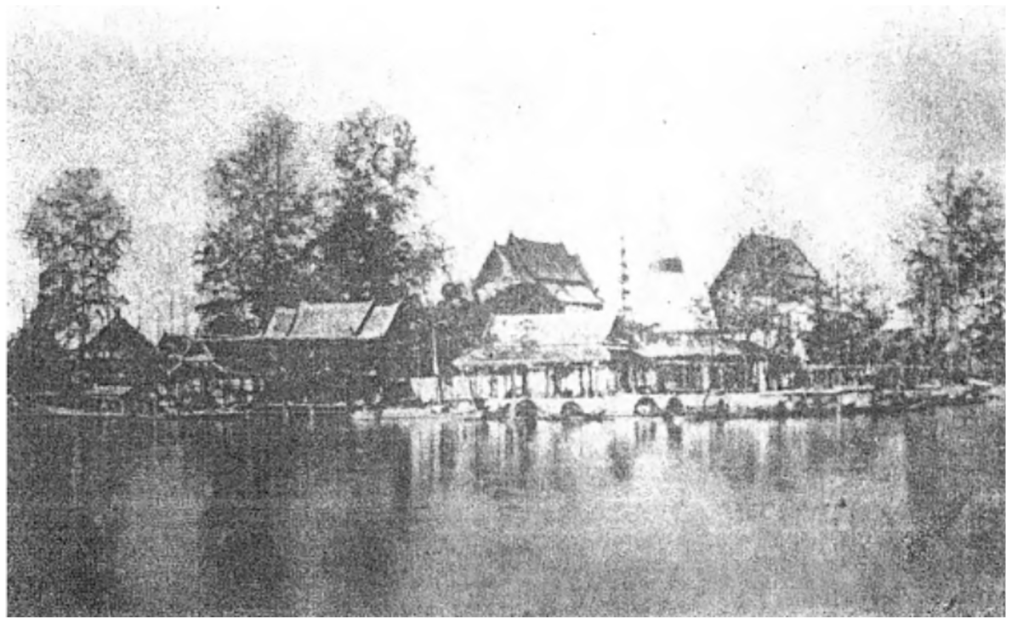
Pathumwanaram temple.
Administrative Reform during the Thai-Imperialism Period
Comprehensive administrative reform of the Siamese royal government took place during the reign of King Rama V, who ascended to the throne in 1873. King Rama V sought to protect the privileges of the Siamese Kingdom and strengthen the royal administrative power after the Bowring Treaty, signed by his father, was in place. By 1875, he had enforced his authority over the old aristocratic group by replacing the traditional government system, composed of four departments: Wiang (city), Wang (Palace), Klang (treasury), and Na (agriculture), with the European bureaucratic model of twelve ministries. 28 Thereafter, Rama V also replaced officers belonging to aristocratic families with his own cousins and sons who had received education from Western schools. Simultaneously, the king also hired hundreds of foreign advisors to assist with government work in different areas, such as public utilities, transportation, finance, revenue, and law. By 1887, he had replaced the position of the second king with the crown prince as the successor. 29 In addition to large-scale government reform, starting in 1897, Rama V also changed the status of provincial governors from rulers of tributary states to that of civil servants of the central government so as to improve tax collection efficiency within the kingdom. 30
Social Classes and Western Education during the Thai-Imperialism Period
In an effort to transform Siam into a civilized country, King Rama V aimed to modify the Siam Corvée system. The king abolished Siamese slavery in 1874, while also setting up a Western educational system by establishing schools for the elites as well as for commoners, such as Suan Kularb Witayalai in 1881 and Mahannaparam in 1884. 31 Western missionaries also played a role in establishing Western schools, examples being the Bangkok Christian School opened in 1852, Assumption College in 1885, and Wattana Wittayalai in 1874. 32 However, inequality among people from different classes was still underlined by their level of education achieved and a Westernized character. Acceptance by Western schools was limited to children from noble families, and commoners were indirectly prevented from attending the schools due to high tuition fees, so they instead sent their children to study in temples. 33
The educational system was further developed during the reign of King Rama VI (1910-1925). More schools for commoners were founded including in rural areas such as Prakhanong. These schools were typically situated next to community temples, which were also considered common gathering places for communities at that time. 34 Furthermore, the king established the Royal Pages School, in the Pathumwan District, in 1910 as an effort to provide a broader range of education in such areas as mechanics, architecture, surveying, and medicine. 35 The school later raised its status and became Chulalongkorn University in 1917, and the Department of University was founded along with the establishment of the institution (Figure 7). In addition, there were several Western professors appointed to develop the educational programs of the institution. 36
Buildings inside the campus of Chulalongkorn University.
Urbanization in the Eastern Area of Bangkok during the Thai-Imperialism Period
During the reign of King Rama V, the landscape of Pathumwan District and Bang Kapi Field changed to be a suburban zone of Bangkok, while Prakhanong and Bang Chak District remained a crucial agricultural zone for the city. This transformation occurred through infrastructure development, such as canals, roads, railways, and tramlines. Meanwhile, land commodification was conducted along the corridor of development.
Canals and Roads
During the reign of King Rama V, several new canals were dug in the eastern and northern regions to improve transportation and irrigation systems in the city. 37 However, the canals were severely polluted and became shallow due to huge amounts of sewage and a lack of maintenance by local authorities. 38 In response to this problem, the Sanitation Act was enacted in 1895, and the Prapa Canal was dug to preserve freshwater. 39
In Siam, land transportation gradually became a preferable traveling choice, while road networks continued to expand in the eastern region. A clear example is the construction of Sathorn Road in 1888. By 1899, Ratchadamnoen Road was constructed to connect the Royal Palace to Dusit Palace, which was the new royal administrative center located in the northern area. 40 This palace construction was also indicative of rising tensions between traditional and Western-oriented groups of aristocrats, already mentioned in the section on Administrative Reform during the Thai-imperialism Period. King Rama V continued to expand the area of new administrative centers into the eastern area by providing urban utilities and constructing palaces and government offices along Pathumwan Road. 41 In 1902, Ratchadamri Road was also constructed to connect areas between Pathumwan and Sala Deang Field in the south. 42
During the reign of King Rama VI (1910-1925), the constructions of roads throughout the region continued with Banthat Thong Road being built in 1912, as well as Phloenchit Road and Witthayu Road in 1920. 43 Also during this timeframe, there was an installation of electric lines in Sala Deang along Wittayu and Sathorn Roads in 1923. Due to the different development projects that were completed, this area became a desirable residential location for both Westerners and Siamese nobles. 44 In addition, several bridges, such as the Yotse (later known as Kasat Suek) and Ratchathewi Bridges, were constructed over canals to facilitate better road transportation. 45
Railway and Tram Services
Pak Nam Railway, the first rail service of Thailand, opened on August 11, 1893, as a result of high travel demand from the capital city to Pak Nam, the port city in Samut Prakan Province. The railway originated in Sala Daeng and ran parallel to Thanon Trong (the current Rama IV Road). In addition, Mae Nam Railway was constructed to connect the riverside area (Chong Nonsri Station) to Makkasan, a new industrial zone of Bangkok. 46 By 1916, the Bangkok Railway Station opened in Hua Lumpong Field after the lengthy construction of the northern rail route, which was started in 1896. 47 In total, there were seven lines of tram service that operated in the city in 1925 (Figure 8), and, of those, just two lines went through the eastern area. The first was located between Yotse Bridge along Pathumwan Road to Ratchadamri Road. The second line went from Charoenkrung Road through Silom Road and ended at Ratchadamri Road. 48
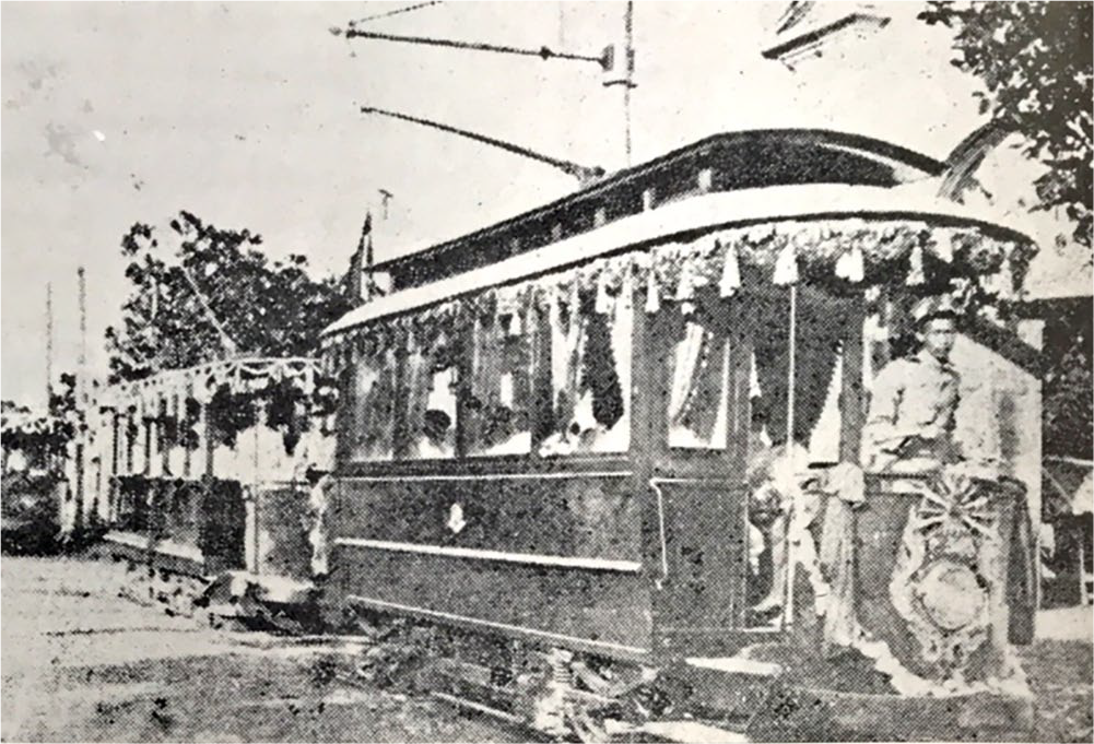
Tram service in Bangkok.
Land Commodification
To promote trade with Western countries, King Rama V instituted land commodification to increase the capacity for agricultural production in the kingdom. 49 The process took place simultaneously with infrastructure development projects, such as road and railway construction and canal network expansion. There were three major public agencies involved in the processes of land commodification and infrastructure development in Bangkok. 50 First, the Ministry of Agriculture was in charge of surveying and managing land in rural areas, such as Prakhanong and Bang Chak. 51 Second, the Ministry of the City was responsible for urban land management and urban infrastructure construction. 52 Third, the Privy Purse Bureau (PPB) was the owner of all public properties, and the agency also leased plots of their land to private renters as residences or retail stores. 53 However, after the Siamese Revolution in 1932, all properties of the PPB were transferred to the Crown Property Bureau (CPB) and the Treasury Department.
There were two major private companies that dealt with land commodification and infrastructure development in the eastern area of Bangkok. Both companies were founded by Siamese nobles and foreign businessmen during the 1890s. The Kuna Siam Company was involved in canal network expansion and land development on both sides of canals. 54 However, the company only focused on increasing property values without any real concern for the impact on the irrigation systems. As a result, a severe drought occurred in 1901, which affected agricultural zones such as the Bang Kapi Field. 55 Second, the Pak Nam Train Company operated the Pak Nam Railway as well as infrastructure construction along the rail route. 56
However, there was a lack of collaboration among local authorities and agencies such as the PPB. The government could not effectively control the concessionaires in operating the development projects. During this time, there were conflicts between the private companies and the landowners because of damages caused by construction. 57 In addition, there were occasional conflicts among landowners due to an overlap of land boundaries within land titles. 58 In some cases, people who occupied the land were not the same people whose names were on the ownership documents. This was compounded by the fact that many local people did not receive possession rights to the land that they lived on. 59
Most of the commodified land plots, especially in the rural zones, such as Bang Kapi Field, Prakhanong, and Bang Chak, were provided to the local residents, 60 while some of the government’s properties were rented for farming. However, because of higher property prices after infrastructure development in the area, most renters, who were poor farmers, could not afford to pay the land rent. Consequently, many of them were forced to leave the land, and local owners instead sold their land to foreigners. Thereafter, the same local residents who could not afford the land rent were then hired by the new owners to work on their properties. 61
Urban Patterns of Eastern Bangkok during the Thai-Imperialism Period
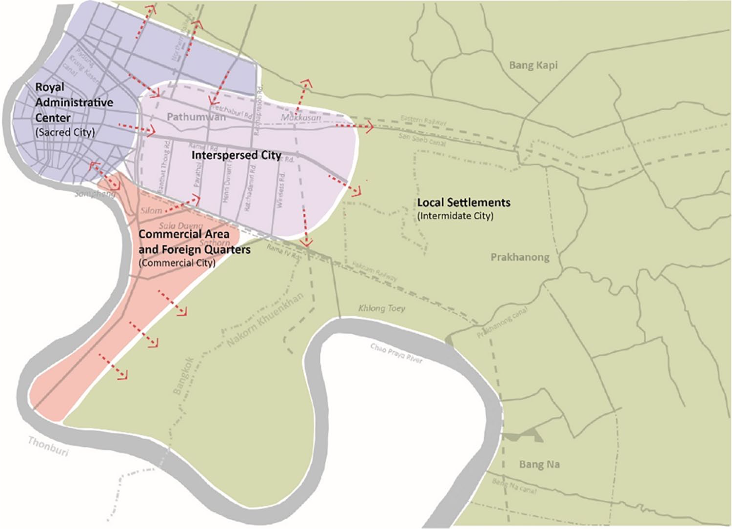
The urban patterns in the eastern area of Bangkok are defined here according to Evers and Korff’s explanation of Southeast Asian urban patterns during the colonial period. These patterns are separated into three groups: (1) the secondary royal administrative center, which handles the activities of the Thai royal government; (2) the commercial area and foreign quarter, which refers to foreign communities and commercial activities; and (3) local settlements, which are the areas of farmland and where local commoners reside. These three groups coexisted and, eventually, they gradually merged together, through the process of land commodification and infrastructure development, to create a new urban pattern of Bangkok.
The Secondary Royal Administrative Center
Following construction of Pathumwanaram Temple and Srapathum Palace during the reign of King Rama IV as the first royal presence in the areas, more palaces were constructed during the reign of King Rama V, which was a result of the expansion of administrative activities from Dusit Palace into the eastern area along Pathumwan Road. Between 1895 and 1910, there were five palaces constructed in a European architectural style in the area: Prince Svastivatan Visishttha’s Palace, Winsor Castle, Srapathum Palace, Phetchabun Palace (Pathumwan Palace), and Vidyu Palace. These palaces were built for the young princes who returned from abroad after graduation, since it was the custom for princes to have the duty of protecting the area on the edge of the city. 62 Because of the expansion of urban settlements during this period, there was an increase in demand for security services; for example, the Silk Department requested more police patrols around its new office in Pathumwan District. 63
Pathumwan was also a center for educational facilities. By 1903, an agricultural school was founded in the area to promote agricultural education, while the school grounds were also used as agricultural experimental fields, specializing in silk production. 64 By 1906, the Police School and a School of Civil Servants were established to train officers for working in the reformed government. 65 The Royal Pages School or Chulalongkorn University was also founded in the same area during this time. The establishment of these institutions helped weaken the Thai class system, while also creating a foundation for democracy in Thai society. 66
To improve health care service to the Siamese people, Chulalongkorn Hospital was founded in 1917, together with the establishment of the Thai Red Cross Foundation, and it was also sponsored by Queen Saovabha Phongsri, the consort of King Rama V. 67 By 1925, Lumpini Park was founded in the Sala Deang Field (Figure 9), the sub-area of Pathumwan, by King Rama VI to hold royal ceremonies and national events, such as the Plowing Ceremony, Coronation Celebration, Agricultural Festival, and Theme Park Fair. 68 In addition, after the completion of construction of minor roads and public transportation services in the area, more government offices and residences of Siamese nobles and Westerners were relocated to Sala Deang. 69
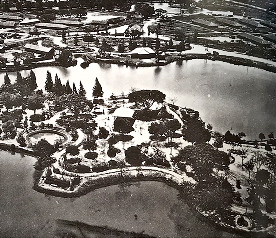
Lumpini Park in 1946.
It can be said that the area of the secondary administrative center reflected a crucial political characteristic of a pseudo-colonial city, allowing a traditional ruler to maintain his authority while continuing to expand the size and function of his royal government. The secondary center, therefore, emerged as a result of this need for more space for the new government units. The flow of activity, from both the sacred city and the new administrative center, was brought to both areas of Pathumwan and Sala Deang along the corridor of infrastructure development. Thus, the once agriculturally based communities were transformed into more developed urban spaces.
The Commercial Area and Foreign Quarters
After signing the Bowring Treaty, the royal government had to relinquish control over trade while also reducing import-export duties. Westerners gained the extraterritorial right to their compounds, which helped Bangkok become an attractive destination among Western and non-Western traders alike. 70 During this time, there was a significant economic change in the country, and Chinese merchants became middlemen traders between Thai elites and Western traders, as well as shareholders with Thai elites in businesses. 71 Meanwhile, there was a large number of Chinese nationals migrating to Thailand in 1912 because of better wages and business opportunities. These migrants were considered a crucial workforce in supporting the urban economy of Bangkok. 72
Trading activities in Bangkok originally occurred at the intersections of canals or at the mouth of the river. 73 However as infrastructure was developed in the city, shop houses were built along the new roads and were provided to Siamese nobles to run their businesses 74 (Figure 10). Some of these new units were transferred to the PPB for leasing. 75 Out of all of the newly constructed roads, Chareonkrung Road was considered the main economic corridor of the city because it connected the areas between the Royal Palace and the riverside, where there was a concentration of commercial activities. 76
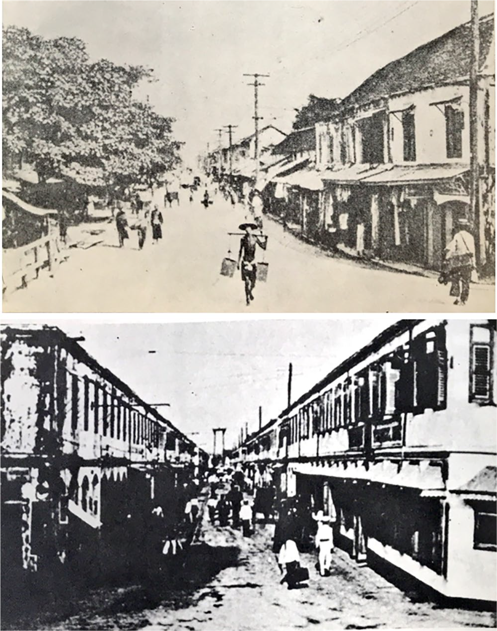
Shophouses along roads in Bangkok.
Many Chinese settlements were located along the City Canal and also the southern Chao Praya Riverbank. Sampheng became the community with the largest Chinese community in Bangkok, and was where commercial spaces such as a Chinese junk ports, markets, retail stores, banks, restaurants, bars, theaters, gambling houses, and brothels were located. 77 After the infrastructure was developed in the area, the settlements expanded eastward along Charoenkrung, Bamrung Mueng, Fueng Nakorn Roads, and also along the Padung Krung Kasem Canal. This resulted in more commercial zones emerging, such as Talad Noi to the east of Sampheng, Bamrungmueng—Fueng Nakorn Commercial District, and Bobae Market at Padung Krung Kasem Canal. 78
However, the Chareonkrung Corridor had poor sanitation, with water pollution, urban flooding, and a garbage disposal problem. This led to several fire incidents occurring in this area, and roads were constructed after the fires to create more open spaces and to try and mitigate further issues. 79 In addition, urban regulations, such as the Canal Act in 1870, 80 the Sanitation Act in 1895, and the Building Regulation in 1916, were launched to improve the hygienic conditions of the area. 81
Next to Sampheng and Talad Noi along Charoenkrung Road, there was a foreign quarter where embassies, Western residences, and warehouses were located. These settlements continued to expand northward into Silom, Sathorn, Bang Rak, and Sala Deang. 82 These areas were also popular for recreation among Westerners and Siamese nobles because of the rich natural environment. 83 During the 1910s, warehouses were moved to the new industrial areas in Makkasan on the northeast, and Khlong Toey (Figure 11) on the south of Pathumwan Field, 84 and the embassies were later moved to Pathumwan during the 1920s due to congestion of the area along Charoenkrung Road 85 (Figure 12).
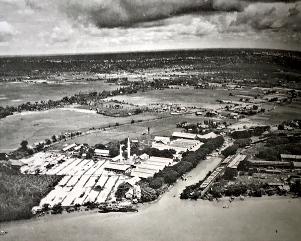
Khlong Toey port in 1946.
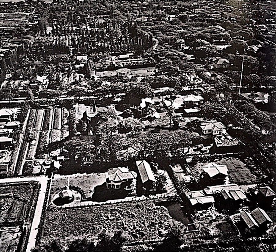
Area of British and American embassies on Phloenchit Road in 1946.
Westerners received several privileges from the royal government. For example, they made requests to move their trading quarter from Charoenkrung to Prakhanong because of its closeness to the port city in Samut Prakan. Consequently, in 1857, the royal government constructed Thanon Trong (Rama IV Road) and other infrastructure to support future trading activities in Prakhanong. The government also anticipated that relocation would reduce tension with foreign merchants. However, once the road was completed, Westerners did not move to the new area due to the inconvenience of the trip between Prakhanong and Bangkok. So instead of becoming a new trading center as expected, Prakhanong turned into a new residential area for wealthy families of nobles and foreign businessmen. 86
By 1892, a group of European businessmen were able to receive low property rental rates for constructing the Royal Sports Club in Pathumwan, while also securing a club business loan without a set payment due date. This sports club became a recreational place for both Westerners and Siamese nobles, with horseracing at the club being the only legal gambling activity within Bangkok at that time. 87 There were also businesses founded through partnerships between Siamese nobles and foreign businessmen, with these companies playing an important role in infrastructure development of the eastern area of Bangkok. 88
In addition to Chinese and Westerners, Indian traders were another important faction in the city’s economy, although their community was much smaller compared with the size of the Chinese community. The Indian settlements were located along Pahurat Road, between Sampheng and the old government center. Among notable Indian community members, A. E. Nana was considered one of the most influential businessmen involved in the urban development of Bangkok. He was notably recognized by owning large plots of land along Phloenchit and Sukhumvit Roads. 89 During the 1890s, Nana purchased several properties in Bangkok and founded a real estate and construction company in 1915. Due to his good relationship with the royal family, he was able to underwrite the accessibility of public services such as tramways and electric lines to support his properties. During the 1930s, Nana took over some properties of Nai Lert, a Chinese real estate company, during its time of financial difficulties, and he also helped royal members financially through buying their land after the Siamese Revolution in 1932. 90
Similar to the secondary administrative center, the commercial area and foreign quarter also expanded into eastern Bangkok, along with the construction of Charoeunkrung Road and Thanon Trong. Land commodification was considered an opportunity for foreign merchants to enter into business collaborations with Siamese nobles and purchase plots of land from local residents. Thus, the activity pattern of the area continued expanding to the other parts of eastern Bangkok, such as Sala Deang, Pathumwan, and Prakhanong.
Local Settlements
During the reign of King Rama IV, there were only a few settlements in Pathumwan, Bang Kapi, and Prakhanong, and several areas were left vacant. 91 After canal network expansion and land commodification during the reign of King Rama V, land titles and land possession rights documents were provided to the local residents, and some properties of the Treasury Department were leased for farming. This resulted in many unoccupied lands slowly becoming large areas of rice paddies. 92 However, there was a decline in agricultural production because of the mismanagement of the irrigation system in Bang Kapi that caused a severe drought between 1896 and 1905. In addition, there were flooding problems during the rainy season, which led to hundreds of local residents moving out into other provinces. 93 Several poor farmers who rented plots of land from the Treasury Department did not have enough money to afford their rent and were forced to leave the land. 94
The majority of local residents in the eastern area were Thai and non-Western commoners. Their residences were built from bamboo and thatch and were elevated from the ground with a veranda in front of the house. Inside the house, there were separate areas for husband and wife, although family members preferred to spend most of their time outside on the veranda. 95 However, because of several fires in the city, all flammable construction materials in high-density residential areas were banned in 1916. 96 Besides the typical traditional local houses along canals and the Chao Praya River, there were also many floating houses of Chinese residents moored nearby. However, these floating houses were later evicted due to the Canal Act 1870 that prohibited any structure from blocking the waterway. 97
Because of the development of roads, which had been going on since the 1850s, Pathumwan, Silom, Sathorn, and Bang Rak became luxurious residential zones. 98 There were also recreational facilities, such as the Sports Club, Lumpini Park, and Nai Lert Park, a recreation theme park on Phloenchit Road owned by Lert Sreshthaputa, a Chinese-Thai businessman. 99 Although Prakhanong remained a prominent farming area of eastern Bangkok, 100 several plots of land in the area were sold with the intention of becoming residences and farming areas of Siamese nobles and Western families, who were fleeing from poor living environments in the inner-city. 101
While the eastern area was gradually transformed into an urban settlement, local people, who still lived a self-sufficient agricultural lifestyle, could not adapt themselves to living in a modern Western lifestyle. These local communities did not gain many benefits from road construction or infrastructure development.
102
From a translation of a short article in the Bangkok Times on October 1, 1910, it is clear that they were seen as poor and uneducated, and were also often disregarded by people from higher classes: About the money deposit issue, People from rural areas such as Wang Thonglang, Bang Sue, and Bang Chak wanted to be fashionable like those Young Siam in the city area. They tried to open an account at the bank, but there was a problem, so all of their money was lost. The bank manager ignored them although they tried to reach him so many times. Thus, they had to dejectedly come back home. Their money may be considered only just a little compared to other customers, but that money was their whole lifesavings.
103
Emergence of the Interspersed City Pattern
As is apparent in the explanation above, instead of showing segregation among the three distinct urban patterns as seen in other colonial cities, eastern Bangkok revealed both the coherence and the isolation between the communities of Siamese nobles, foreigners, and the local commoners. An interspersed city emerged as an extended area where activities of the secondary administrative center, the commercial and foreign quarter, and local settlements overlapped, and the area was also considered a rural area that could be conveniently accessed by roads.
As shown in Figures 13 and 14, Pathumwan Field was the first area that showcased an interspersed city pattern, with dual physical characteristics between rural traditional and modern settlements. The field was originally considered a large area inside the intermediate city, where traditional rural communities were concentrated along canals, such as Saen Saep Canal, due to their traditional and agricultural lifestyles. This was gradually occupied by the royal family after King Rama IV constructed Srapathum Palace and Pathumwanaram Temple. During the reigns of both King Rama V and King Rama VI, more palaces and government facilities were constructed along Pathumwan Road (the current Rama I Road) in connection with the construction of Dusit Palace, the new royal government center in the northern area.
Semi-colonial urban pattern of Bangkok.
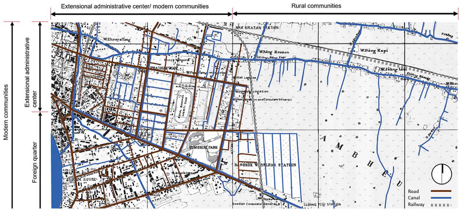
Dual existence of modern and rural communities.
Although King Rama V attempted to improve agricultural production capacity in rural areas by developing an irrigation system, the land prices in Pathumwan became too high for commoners to afford as a result of several infrastructure and facility developments in the district, which led to a decline in agricultural communities in the area. There was also a severe drought during the 1900s, which resulted in a large number of local residents moving out to other provinces.
In tandem with local residents moving further outside the area, there was an influx of urban-based residents moving into the area because of its desirable qualities as a residential environment. Foreign residences and embassies relocated to Pathumwan after the construction of roads (such as Phloenchit, Wittayu, and Ratchadamri Roads) that connected the area to the commercial zone on the southern riverbank.
In addition to Pathumwan, the area of the interspersed city pattern continued expanding eastward through development of infrastructure and increased occupation of the area of intermediate cities. For example, a part of Prakhanong was also transformed into another interspersed city after the construction of Thanon Trong (Rama IV Road) and Pak Nam Railway to shorten the trip between Bangkok to the port city in Samut Prakarn. Therefore, the area became another preferable living location and also a vacation destination for Western and non-Western merchants. Meanwhile, the area was still considered a prime agricultural zone of eastern Bangkok.
The relationship between Siamese nobles, Westerners, and non-Western traders could also be physically illustrated through the development of the interspersed city in Pathumwan and Prakhanong. Siamese nobles and Westerners became business partners on several occasions due to the founding of local schools and the developing infrastructure of public facilities. Meanwhile, Chinese and Indian businessmen took roles as middlemen between Siamese nobles and Westerners. These business actors occasionally socialized at recreational places, such as theaters, sports clubs, and hotels in the areas of commercial cities. Although there was no conflict between the different populations, they were still aware of each other’s influence and status in the port city in Samut Prakarn.
Conclusion
The urban transformation of the eastern area of Bangkok during the Thai-imperialism period (1855-1932) was a result of the colonial prevention policy enacted by the royal government. The process was determined by four factors: (1) the enactment of land commodification, (2) the construction of infrastructure and facilities, (3) the expansion of the irrigation systems, and (4) the development of the Western educational system. Agricultural production in the area was significantly improved while the area also became more attractive to Siamese nobles and Western residents. This created a dual existence between the canal-based rural communities and Westernized road-based communities.
Similar to other Southeast Asian cities during the same period, Bangkok still shared common urban patterns, which were sacred, commercial, and intermediate cities. The sacred city, which was an administrative center for the royal government, was located on the east side of the Chao Praya River, and the area was defined via the boundaries of the two city canals. In addition, the commercial city included areas of Chinese settlement and Westerners’ quarters, which were situated along both the southern bank of the Chao Praya River and Charoenkrung Road. Finally, the intermediate city referred to the large agricultural areas in Bang Kapi and Prakhanong where traditional settlements were allocated space.
However, unlike other Southeast Asian cities, an interspersed city pattern emerged in Pathumwan, and revealed a unique spatial pattern for the pseudo-colonial city of Bangkok, as the area was considered an extended zone of both the sacred and commercial cities. The area also gradually expanded and replaced the area of the intermediate city. This new interspersed city pattern reflected the economic inequality between residents with traditional lifestyles and those with urban Western lifestyles. This was indicative of the relationship between Siamese nobles and Westerners, who were involved in the urban development of the eastern area of Bangkok. They could be considered competitors, collaborators, and beneficiaries of each other simultaneously.
Footnotes
Declaration of Conflicting Interests
The author(s) declared no potential conflicts of interest with respect to the research, authorship, and/or publication of this article.
Funding
The author(s) received no financial support for the research, authorship, and/or publication of this article.