



Abstract
Tianditu is China’s first state-sponsored web mapping service. Beijing considers Tianditu part and parcel of its burgeoning endeavor to build a ‘digital China’. The Chinese state created Tianditu to regain some of the ground lost when its monopoly on geographic information was effectively broken. This effort goes hand in hand with Beijing’s intention to compete with and shrink the space occupied by Google mapping services (Google Maps, Google Earth, etc.). Although Tianditu does bestow a certain degree of power on civilian users to interact with and explore geographic data, for political and social reasons the Chinese state tightly controls Tianditu. It is a tool that the regime uses to maintain political power and push ideologies it supports. This type of top-down reinforcement of static geographic knowledge is a far cry from the concept of civilian empowerment as understood in liberal democracies.
Keywords
On 21 October 2010, China’s State Bureau of Surveying and Mapping (SBSM) launched the beta version of Tianditu (www.tianditu.com), which was China’s first official free web mapping service. In English, Tianditu means ‘Map World’. State media suggests that about 30 million netizens from over 210 countries and regions visited Tianditu after the beta version came online (Today’s Media, 2011). After beta testing, Tianditu was officially launched on 18 January 2011. In June 2011, a trial version for mobile phones came online. And in October 2011, the mobile phone version was officially launched.
Featuring a home page with a picture of China’s Great Wall, reports issued by Chinese journalists and academics have praised Tianditu as a significant contribution to China’s ongoing effort to build a digital China (Dong et al., 2011; Ma, 2011; Nanfang Daily, 2010; Ren et al., 2011). This article will explore the technological and sociopolitical implications of Tianditu.
Online mapping services can be understood as online cartography backed up by a geographic information system (GIS). GIS was originally a tool for cartographers, geographers and other types of specialists to store, manage, present and analyze spatial data. In bringing GIS online, the web has made these tools available to a much wider audience (Kraak, 2001). Furthermore, with the advent of broadband, utilizing GIS has become much faster and easier. Increasingly, non-specialist members of the public can access, look up and make use of geographic information for their own purposes. Launched in 1996, MapQuest was the first widely known online mapping service. Since then, other internet companies like Google and Yahoo have begun offering web mapping services with different types of interactive features.
Beijing has repeatedly stressed that the purpose of Tianditu is to offer comprehensive geographical data to Chinese users, enabling them to learn more about the world for educational purposes, for travel, for environmental resources management and many other reasons. Nevertheless, in terms of its technological and sociopolitical ramifications, there has been great criticism, suspicion and debate about the service. For the Chinese government – an authoritarian regime that has a well-established record of controlling the geographic information its citizens are permitted to access – what are the motives for offering a free online mapping service? As Tulloch (2007) has observed, citizens in democratic countries can freely access geographic information for personal and public use. Can Tianditu fulfill the same purpose of empowering Chinese citizens? Or does Tianditu serve the opposite purpose – namely, helping the Chinese government control what citizens can read, understand and perceive about the world? In what ways does Tianditu empower Chinese citizens, and in what ways does it disempower them in comparison with citizens accessing other online mapping beyond China’s control? As noted, since the launch of Tianditu, there have been reports from journalists and online discussions about its technological and sociopolitical implications, both within and outside China (Ma, 2011; Nanfang Daily, 2010). One also finds articles written by academics in China in Chinese publications praising the prospects for the service in a China that is continuously digitizing its infrastructure to boost educational, research and civil progress (Dong et al., 2011; Ren et al., 2011). However, there is as yet little or no published English-language research offering an introduction to and comprehensive discussion of Tianditu. This article begins to fill the gap.
Throughout this article, Tianditu is analyzed in comparison with Google. Both Tianditu and Google offer more than just images of maps stored as bitmaps, placed on the web, and enabling interaction between users and systems (Kraak, 2001). Google has been chosen for comparison – not only because of its contemporary popularity, but because whenever netizens comment on Tianditu, it is most often compared with Google. For instance, many users question whether Tianditu is just an imitation of Google (Nanfang Daily, 2010). Netizens in China and elsewhere have posted images extracted from both Tianditu and Google to compare them, and have found them to be identical – except that those from Tianditu are in Chinese. There are also complaints about the quality of Tianditu’s service because the data is updated only about twice a year, while Google is updated much more frequently – as often as every few minutes. But as these comparisons are generally informal among members of the public, it is imperative to begin to form an academic perspective.
Before we proceed, it is vital to note that this work is related to a wider scholarly exploration of how maps, as a medium, are often manipulated illustrations of the cartographers’ conscious or subconscious visions (Harley, 1989; Wood, 1992). Edward Said (1979) argues that geographic knowledge is typically constructed by the local culture. Maps play a crucial role in narrating such imaginative spatial knowledge (Said, 1979). Similarly, Benedict Anderson promotes the idea that a nation is an imagined political community because no one could ever travel to every corner of a nation and become acquainted with every person therein, yet ‘in the minds of each lives the image of their communion’. Maps are one of the media that a governing authority can use to facilitate the construction of imagined communities (Anderson, 1991).
The second section of this article begins to outline the conventional measures the Chinese government has historically taken to manage the spread of geographic information and construct geographic knowledge that it expects its citizens to have: the monopolization of map production and the execution of extensive map censorship. In section three, we argue that these two measures have been expanded to encompass online map management. Section four includes survey results from GIS and cartographic experts, comparing the technological design and features of Tianditu to those of Google. A technological comparison not only enables us to examine the various features per se but also directly illustrates what exploratory capabilities the designers of these services expect to bestow on users. This leads to a discussion in section five about whether and in what ways Tianditu empowers civilian users.
China’s grip over map production
Before web cartography emerged, the Chinese government imposed two measures for controlling the spread of geographic information: the monopolization of cartographic publications and the creation of regulations on map use and screening.
Monopolizing cartographic publications
Before 1954, there were no regulations stipulating which people and organizations could publish cartographic productions. In 1954, the Chinese government ordered the 16 largest publishers of cartography in the country to merge into a single firm known as SinoMaps Press, which is based in Beijing. Within ten years of this forced merger, almost every map available in China, from administrative maps to road maps, tourist maps, educational maps, maps for academic surveying and historical maps, were published by the firm.
In recent years, a growing number of publishing houses have been permitted to publish maps for regional transport and tourism. However, only SinoMaps Press is allowed to publish world maps or national maps of China. 1
With map publication centralized, the Chinese government is able to much more easily control the dissemination of geographic information. Standardized and regulated versions help the regime reinforce its traditional interest in controlling what citizens see and perceive about the world in terms of cartographic representations. The regime’s claim to a particular territory, particularly when it comes to politically sensitive regions like Taiwan, Tibet and Xinjiang, goes hand in hand with the production of cartographic representations to support those claims. This will be further manifested in this article. As SinoMaps Press unabashedly asserts on its website, ‘this publishing house’s administrative maps of China and political maps of the world play an invaluable role in maintaining the sovereignty of the motherland and teaching territorial identification’. 2
Map screening
China’s state monopoly goes hand in hand with its map screening regulations. According to Articles 17, 18 and 21 of the Regulations of the People’s Republic of China on the Management of Map Drawing and Publication, if a map is to be published, or exhibited without being published, it must first be submitted for government examination and approval. 3 Furthermore, the SBSM, the senior approving agency, has special rules for screening maps.
For instance, Article 4 of the SBSM rules demands that the accuracy of all geographic locations must be drafted to a scale up to 1:500,000. To make a comparison, in the United States, maps can be published at various scales. The US uses 1:24,000 as its largest (i.e. most detailed) scale. China’s preference for maps drawn at 1:500,000 make things appear rather tiny. Details like small streams, roads and landmarks are therefore left out altogether.
Furthermore, if maps are drawn to a scale larger than 1:500,000, they must not show longitude and latitude or geographic coordinates (Article 5 of the SBSM rules). This may at the first sight appear counter-intuitive. For cartographers and GIS experts, the standard mandate is to ensure that maps are accurate and scientific. How can a government demand that productions of its nation’s map be imprecise? On second glance, however, one can understand this as an expression of Beijing’s fear of publicly revealing geographic information considered a state secret, when it considers such exposure to be damaging to the nation’s interests.
Another example involves Article 6 of the SBSM rules, which stipulates that all historical maps depicting years after 202 BC must show Chinese territory as it appears in contemporary maps. This is in stark contrast to historical reality. For more than 2000 years China’s territories have been subject to change. For instance, throughout history, Xinjiang has passed in and out of Chinese control. Nevertheless, the Chinese government stipulates that all cartographic depictions of Xinjiang that cover the past 2000 years must show it to be part of Chinese territory.
Article 17 of the SBSM rules is also worth noting. Article 17 demands that many Russian locations must show Chinese names in addition to their Russian names. After China ceded territories to Russia in the late 19th century, many of these locations were given Russian names. 4 For instance, a city known in Chinese since the Qing Dynasty as Haishenwai is known internationally as Vladivostok (which means ruler of the East). This is done according to international practice: if an area now belongs to Russia, it must be named on maps in Russian.
Nonetheless, Beijing has ordered that in addition to Russian, many Russia-governed areas be noted in Chinese. This implies China’s aspiration to restore its historic territory and uphold national pride.
Publishing incorrect locations or information, which means publishing place names and borders that the authorities disagree with, is a violation of Chinese law. This grip of the Chinese state over map production results in a near standardization of maps and map-making techniques. This phenomenon is different from the practice in most liberal democracies, where map production is less regulated and maps can be drawn by anyone, regardless of their perspective or purpose. In other words, in the liberal democratic tradition, map makers and map readers are permitted to perceive and observe the world with little or no government constraint.
While according to western liberal standards, Beijing’s control of what can and should be revealed in maps might stir criticism, cartographers themselves find this less of a surprise, as China is far from the first regime to impose this type of manipulation.
Researchers of cartography have long recognized that while maps can present accurate, neutral and scientific geographic information, they are also often drawn – consciously or unconsciously – to reflect the ideologies and viewpoints of the authorities (Chen, 2007; Lay et al., 2010; Wood, 1992). This is demonstrated by many European world maps, which depict Europe as being at the center of the world. Readers may also be familiar with world maps created by the Antipodeans, which appear to turn the world upside down.
In sum, almost every type of map is subject to manipulation, depending on the intentions and ideology of those who create them. State-produced maps, whether they are produced in China or a liberal democracy, are critical tools for maintaining authority over the territories and inhabitants the authorities claim. In this regard, if one wishes to pinpoint the difference between China and the liberal democracies, it would be that in China civilian mapping is highly constrained, while in liberal democracies the ‘plurality’ of cartographic representation by civilian map makers is the norm.
Chinese cartography in the era of the worldwide web
Through its monopoly on cartographic publication and screening mechanisms, the Chinese government once had nearly complete control over the spread of geographic information. But with the arrival of cyber mapping, this control has been challenged. Although compared with the liberal democracies, web access in China is not entirely open, the internet does create more opportunity for Chinese netizens to surf and research. There are quite a number of people in China who enjoy drawing ‘un-approved’ maps as well as collecting foreign maps in order to obtain a more pluralistic perspective of the world. The internet opens up wide range of channels for them to share, exchange and discuss these interests. Many foreign maps or maps that are not approved by the Chinese government are freely available online and can be accessed by Chinese netizens.
Facing this new challenge, the Chinese government began the ‘Initiative to Govern Problematic Maps’, which involves cleaning up un-approved maps in cyberspace. For instance, there used to be an ‘Administrative Planning Forum’ comprised of Chinese fans of administrative maps. Its members often exchanged self-drawn administrative maps. But there was a crackdown on the forum, so members had no choice but to move the forum’s server to the United States, and to re-establish the forum under the name ‘Map Forum’ (http://bbs.xzqh.info).
In tackling cyber mapping, the measures Beijing has taken are similar to those it imposed for paper maps: the monopolization of web mapping and the imposition of web map screening regulations.
Monopolizing web maps
To discuss the monopolization of web maps, it is worth noting how unusual it is for Beijing to unleash its geographic data to the point of making it freely available online.
As previously mentioned, Beijing has traditionally treated geographic data as confidential information vital to national security. For instance, in January 2009, three British geology students were caught in Xinjiang Province, where Chinese authorities believed their surveying and map-making efforts posed a threat to national security, and thus were unlawful (Spencer and Simpson, 2009). Beijing considers Xinjiang a politically sensitive region because residents there are Uyghurs who wish to obtain greater autonomy or even secede from China. Sporadic clashes between Han and Uyghur Xinjiang residents have even appeared in the international press over recent years, making the Chinese regime extremely wary of foreign activities there (Chen, 2012a). Another recent example was in 2012, when an American in the same region was fined for illegal mapping, even though he claimed he wanted to use the collected geographic information to run a travel agency serving foreign tourists in Xinjiang (China Daily, 2012).
So China’s unusual move to make geographic data freely available online should be understood in the context of the government’s ambition to develop a competitive domestic online entertainment environment which can simultaneously serve as a means of control over access to online geographic information by Chinese netizens. Hence we see the birth of Weibo (www.weibo.com) as China’s answer to Twitter, Renren (www.renren.com) to replace Facebook, Youku (www.youku.com) to replace YouTube, and now Tianditu to replace Google Maps and Google Earth. Tianditu can therefore be regarded as a pre-emptive move to allow citizens to obtain regime-approved geographic information and not rely on mapping services from abroad, which provide ‘contaminated’ information that undermines Beijing’s interests.
To achieve monopolization, it is imperative for China to squeeze competing web mapping services out of the market. Before Tianditu, there were already quite a few Chinese and foreign websites offering mapping services. Five months before Tianditu was officially launched in October 2010, the SBSM issued a regulation demanding that all companies wishing to provide online map services in China apply for a license. In order to obtain the license, companies have to agree to maintain their mapping servers in China. This created an unfavorable situation for Google, as the company aspires to greater control over its own data and servers. In March 2010, after the company’s mainland servers suffered major attacks in 2009 (presumably from the Chinese government), Google re-directed its search engine from mainland China to Hong Kong. As Tianditu seeks to offer functions similar to those Google mapping service provides, one can see the creation of Tianditu as part of Beijing’s strategy to squeeze Google out of the China market, eventually making Tianditu the main source of geographic information for Chinese users. This can be seen in various government publications that tout Tianditu as the ‘authoritative’ source for online geographic information. For example, as Ma (2011), points out in her interview with SBSM Director General Xu Deming, the ultimate aim is to create ‘one web, one map, and one platform’, offering the most authoritative and comprehensive web mapping services to Chinese citizens (Ma, 2011). Xu Deming also emphasized that Tianditu would be a ‘reliable and excellent national brand’ in the field of online mapping services. Beijing’s ambition to ‘monopolize’ the places from which citizens obtain online geographic information is therefore apparent (Chen, 2012b).
Web map screening
Web map screening goes hand in hand with the goal of monopolizing the provision of online geographic information. According to Article 19 of the SBSM rules, cyber maps should be drawn based on the demonstration maps on the SBSM website. The birth of Tianditu can be said to have satisfied the urgent need of SBSM to define what counts as an acceptable cyber map. Hence, all geographic content revealed in Tianditu follows the drawing guidelines of the SBSM.
Figure 1 is an example of different Sino-Indian borders drawn by Google and Tianditu. It shows how Arunachal Pradesh becomes a part of Tibet belonging to China according to Tianditu (Figure 1A). This reveals the Chinese government’s intention to show its people that the territorial dispute has been solved (Deepak, 2011; Soni and Marwah, 2011). This is different from Figure 1B, which was extracted from Google Maps and encircles Arunachal Pradesh in dashed lines, illustrating to the users that this territory’s sovereignty is contested. In other words, Google shows disputes while Tianditu shows absolutes. 5
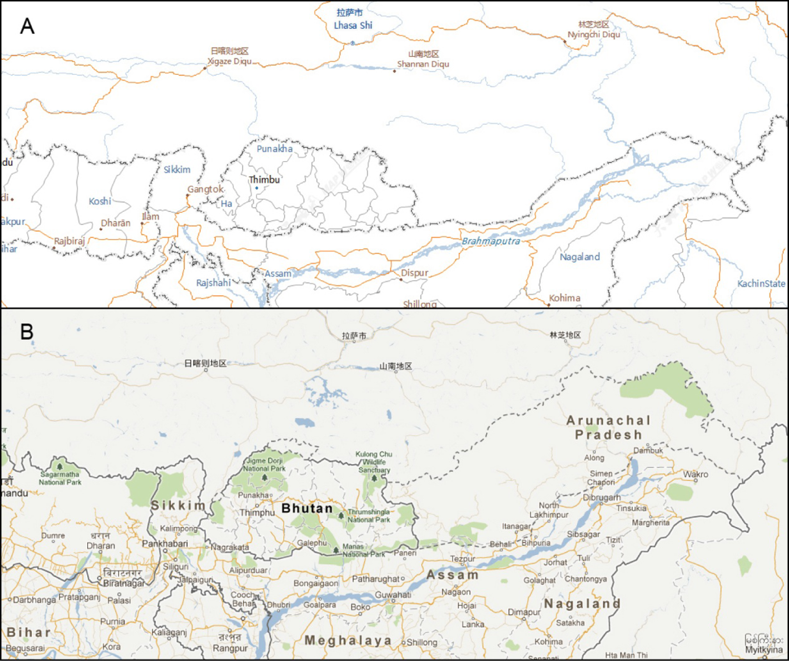
A comparison of Arunachal Pradesh as revealed in Tianditu (A) and Google (B)
As with the production of traditional paper maps, the Chinese regime has shown an ambition to assert political claims over a number of controversial geographic locations in its own version of the world map. Apart from the example shown in Figure 1, to no one’s surprise, on Tianditu, Taiwan is labeled a province of China. The Spratly Islands in the South China Sea are included as Chinese territory, although countries like Vietnam and the Philippines also claim sovereignty over the islands. Similarly, the disputed Diaoyutai Islands are listed as Chinese territory, although the Republic of China (Taiwan) and Japan also lay claim to them (Yap et al., 2012).
The desire to incorporate contested regions like Taiwan, the Spratly Islands, the Diaoyutai Islands and Arunachal Pradesh into Chinese territory reflects Tianditu’s function as a tool for marking out China’s political claims over these areas. Contrary to what many people believe – that maps should present accurate geographic information for users to understand our world – Beijing regularly uses cartographic production to impose views for citizens of ‘their’ country and ‘their’ world. What is ‘accurate’ for China might not be for other countries that also lay claim to these contested territories. Apart from the fact Tianditu’s maps of China are digital, they are no different from traditional paper maps in terms of being tools that the regime uses to visually reinforce a sense of territorial bonding. This helps the regime legitimize the relationship of the Chinese state and its territory, stressing its authority and possession (Batuman, 2010).
The design of Tianditu
This section looks at the technical design of Tianditu. To render the discussion more accessible to non-GIS experts, Tianditu is again compared to the more widely known Google. A discussion of these technical issues is relevant to our purposes in terms of highlighting the sociopolitical implications of Tianditu, as it will demonstrate what the service’s creator intends to bestow on users in terms of functionality and the type of empowerment these functions can offer users.
A brief visit to Tianditu impresses on users that it contains a fairly large number of both 2D maps and satellite images. Like most other online mapping services, such as the more widely known Google, one can search for places, identify points of interest (POIs), calculate distances and obtain information about possible driving routes. It provides features that satisfy the basic needs people have in terms of checking geographic locations and planning trips, and it also has inherent educational value for students working on class work and homework. These appear to fulfill yet another of Beijing’s central objectives for Tianditu: satisfying the demands of the Chinese public for geographic information for entertainment (e.g. tourism) and educational purposes. Furthermore, like online and offline mapping systems elsewhere in the world, Tianditu is said to be appropriate for scientific research, as manifested in Dong et al.’s 2011 paper indicating Tianditu’s applicability in earthquake studies.
During March and April 2012, a qualitative expert survey was carried out to evaluate the design of Tianditu in comparison with Google. The experts are cartographers and GIS analysts. Two are currently based in mainland China (termed experts A and B in Table 1), two are based in Taiwan (experts C and D), and one is based both in mainland China and Taiwan (expert E).
Expert comparison of Tianditu and Google
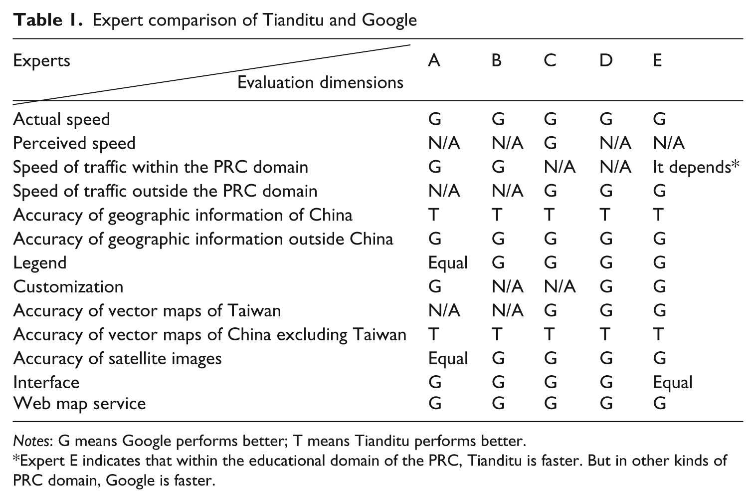
Notes: G means Google performs better; T means Tianditu performs better.
Expert E indicates that within the educational domain of the PRC, Tianditu is faster. But in other kinds of PRC domain, Google is faster.
In the open questionnaire, the experts are first asked to evaluate the speed of the online mapping service. Because the service involves large amounts of geographic data, fast throughput is important. Most experts agree that Google is faster in both actual and perceived terms. When a user inquires about a specific piece of geographic information, Google presents a graphic representation that gives the server time to acquire the cached data. Hence, during the interval in which the user is waiting for the requested information to appear, he or she has the visual perception that Google is incrementally revealing the data. Tianditu has no such function; during the interval after the user makes a request, the screen simply goes blank. This leaves the unpleasant impression that Tianditu is slow in retrieving data. In evaluating the speed of an online mapping service, sometimes perceived speed is more important than actual speed, since web users generally expect instant feeding of information as they click and browse. Any moment the screen turns blank implies waiting, and discourages continuous browsing of the website. In brief, in terms of actual and perceived speed, Tianditu fares badly in comparison with Google.
Regarding the accuracy of geographic information, all experts agree that overall, Google provides geographic information that is much more accurate than Tianditu’s. For instance, Tianditu’s accuracy for longitude and latitude is only to the second digit after the decimal point. Precise to the sixth digit after the decimal point, Google greatly outperforms Tianditu.
Another example is Taiwan’s Taipei County, which updated its status to a city and re-named itself New Taipei City in 2010. Google Maps accurately reflects the change, while the current version of Tianditu (2012) has misinformation. There is an option named ‘New Taipei City’ for users to click on. But the place name ‘Taipei County’ rather than ‘New Taipei City’ is shown on Tianditu’s map. The mismatch confuses users as to whether ‘New Taipei City’ or ‘Taipei County’ is the current name.
When it comes to place names in mainland China, however, Tianditu has much more accurate and up-to-date information than Google. For instance, Tianditu outperforms Google in offering more detailed information about China, even in remote mountainous and rural areas. Exceptions are in politically sensitive areas where Beijing has issued regulations leaving them as vague as possible.
The experts are also asked to gauge whether Google and Tianditu are sophisticated enough to offer clear legends and readable geographic information. Experts all agree that Google provides users background colors that are pleasant to the eye (a mild yellowish hue). Whereas Tianditu’s colors for base maps and major roads are arranged in red and orange – two colors that are too close visually, making it hard for users to discern different types of geographic information.
Concerning the user interface, Google and Tianditu are level-pegging. If users have experience with digital maps, they should have no problem using both systems. The only disadvantage of Tianditu is that it only supports Chinese, whereas Google has multilingual capacity. Users whose mother tongue is not Chinese will find less or no appeal in using Tianditu when it comes to researching geographic information.
In addition, experts assessed whether the online services are customizable enough, easy enough to navigate and share with others. Google Map provides KML and KMZ, two kinds of file formats that enable users to customize Google Earth pages that are being accessed. For instance, users can directly allocate placemarks or image overlays from Google Earth. Tianditu lacks these types of files. What Tianditu does offer and what Google can also do is the possibility for users to import Tianditu’s geographic data. But the system appeared unstable when experts actually tried to import data from Tianditu.
Moreover, Google is often touted for the 360-degree ground-level imagery of street views it offers of places around the world. But this does not include Chinese street views. Tianditu has Chinese street views, not in the form of 360-degree ground-level imagery. Even so, Chinese streets still appear much more clearly than on Google.
Both Tianditu and Google provide for the possibility of route mapping. Google integrates local traffic information into this function. It is also possible to integrate both local and international traffic information when exploring routes. Users can design their routes based on how they wish to travel: public transportation, driving or walking. Tianditu, however, only has the driving option, and route analysis is only possible for certain countries.
In addition, Google mapping service features commercial advertisements. Customers can search directly for companies, restaurants, shops, etc. Tianditu is relatively weaker in this respect. Users of Tianditu will find that such function is usually copied from Google. This also suggests that Google also outperforms Tianditu in terms of commercialization. This makes sense because, even though the Chinese government has turned Tianditu into a company, it is a state-sponsored enterprise (SOE) that essentially functions like a governmental agency, not a commercial firm. 6
Technically speaking, overall, Google outperforms Tianditu. Given that Tianditu is in its nascent stage, it is expected that in the years to come, more will be done to improve its quality.
Tianditu and the (dis)empowerment of Chinese netizens
The implications of Tianditu’s design and techniques are not only technological. These functions directly affect Tianditu’s acceptability to Chinese netizens, which might further influence their cognitive knowledge of the geographic information released by Tianditu. When Tianditu is used by more Chinese, the geographic information that Tianditu emits will have greater sociopolitical repercussions.
Some scholars (e.g. Tulloch, 2007) are sanguine about how online mapping empowers the general public, and even people who are marginalized, to participate in the generation and application of geographic information. The observations of such scholars are usually based on experiences in the liberal democracies. Can Tianditu, a product sponsored by an authoritarian regime, play the same role as services like Google mapping do in the liberal democracies, and how?
This article provides two ways to address this intriguing question. The first is to look at the technical functions as laid out before, in a conceptual ‘map use cube’ proposed by MacEachren and Kraak in 1997. This is called technical empowerment. The second is about knowledge empowerment. It evaluates the geographic knowledge released by Tianditu and how it (dis)empowers Chinese citizens. Below is the detailed discussion.
Technical empowerment
The map use cube looks at three conceptual axes (Figure 2) representing three different map use continuums: high interaction versus low interaction, presenting known versus revealing unknown, and private versus public (MacEachren and Kraak, 1997; Van Elzakker, 2001).
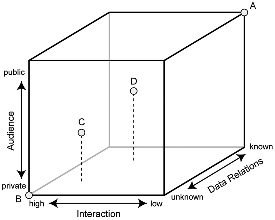
Google and Tianditu in the map use cube
A traditional paper map is a static map providing low interaction with readers. Highly interactive maps, at the other end of the axis should allow users to explore the data. Hence, the concept of interaction is related to exploration uses.
A traditional paper map aims to present static information. Users simply retrieve the data from the map. This is ‘presenting known’. ‘Revealing unknowns’ means that users are not sure whether there exist spatial relationships in the data. They have to explore to find out.
Up to this point, one can see that highly interactive maps are more likely to enable the exploration of unknowns, while less interactive maps tend to present knowns. These concepts are related.
The concept of ‘private’ means that map data can be freely accessed and manipulated by users, while ‘public’ means that completed maps are made available to a group of users; and there is no way to manipulate the data any further.
A traditional map (denoted A), located at the upper right corner of Figure 2 represents a map with little interactivity and presenting knowns, and is usually made available to a vaguely defined public group of users. A conventional desktop GIS (denoted B), differently, should be located at the lower left corner of the cube, as it can be used for private needs to explore unknowns and thus is highly interactive.
The technical discussion in the previous section leads us to conclude that Google and Tianditu situate somewhere between these two extremes (A and B). Relatively speaking, Google (denoted C) is more interactive, allows more options to explore unknowns and can be more private than Tianditu (denoted D).
Thus, when we consider the empowerment question, Google is more capable of bestowing private users exploratory capabilities, and giving more leeway to do what they want with the data. Tianditu is relatively less mature in its design when it comes to empowering civilians.
For Tianditu specifically, some parts of its functions are closer to enabling private exploration of unknowns at the lower left corner. We tend to assume that the western liberal notion of empowerment is more likely to occur there. Can empowerment occur in fixed and embedded knowns at the upper right corner? The next section answers that question.
Power embedded in Tianditu
As noted, Beijing tightly controls basic geographic knowledge of Chinese territory under the rubric of national interests. Essentially, Tianditu contains some embedded knowns not to be explored and challenged. Maps, as a representational tool for geographic information, can help the state reinforce national identification with territory and maintain its political power. As said, this is not unique to authoritarian regimes. Most national governments, including democratic ones, offer more or less official cartography to serve state purposes (Batuman, 2010). The difference between liberal democracies and authoritarian regimes is that in the former there is a chance for popular cartography to flourish. Popular cartography does not necessarily oppose the state-centric discourse of official cartography, but it can offer alternative ways of depicting geographic data. Authoritarian regimes, on the contrary, lack such diversity.
This type of top-down reinforcement of static geographic knowledge is a far cry from the concept of civilian empowerment as understood in liberal democracies. Some liberals might even call this ‘disempowerment’. This article does not side with either the Chinese state or western liberal views to judge Tianditu. Rather, the aim is simply to present the contradictions and tensions by examining Tianditu within the framework of the bottom-up participatory GIS literature spawned in liberal democracies.
Conclusion
With Tianditu becoming a new platform for the Chinese state to promote its national interests, Beijing appears to see the benefits of exploring similar platforms. For instance, in 2011, the SBSM unleashed the Red Map series to commemorate the communist party’s 90th anniversary. Users can access the Red Map series through the websites of the SBSM or Tianditu. As Ren et al. (2011) observe, the Red Map series uses ‘cartographic language’ to showcase the communist party’s contribution to China. Figure 3 shows one of the Red Maps that allow users to obtain a general idea of where in China communist leaders were born. Through the platform of web cartography, one can see the materialization of communist and nationalist ideologies, evoking China’s unique socialist character.
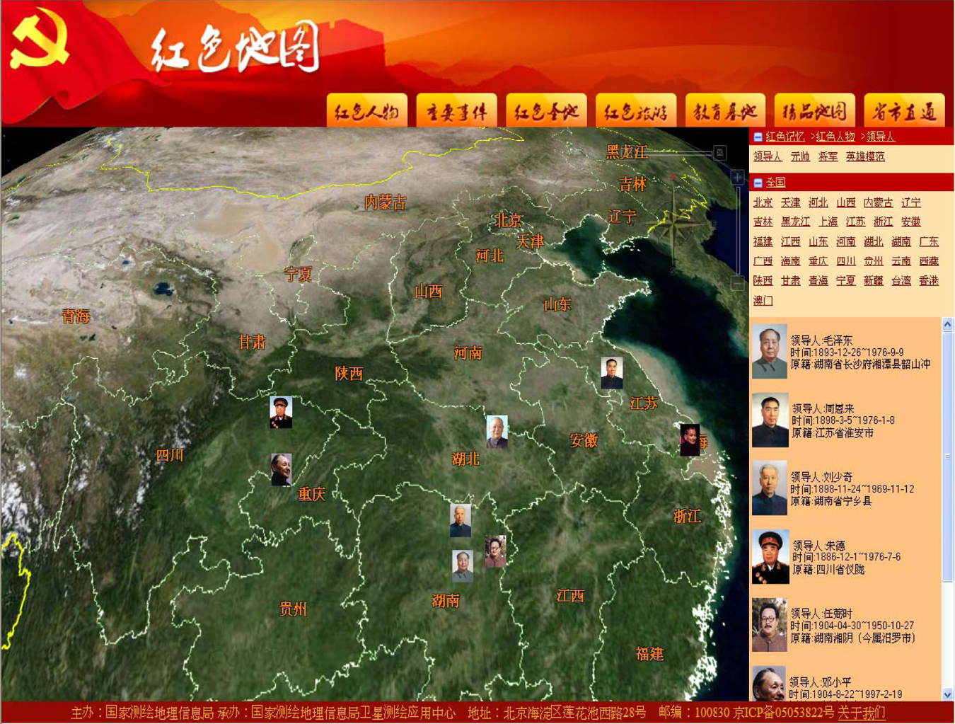
A map from the Red Map series
To conclude, the Chinese government’s web mapping techniques are catching up technologically. As it develops, however, it will be prone to using this technology for political and social ends. While Tulloch (2007) is right to assert that the internet and online mapping services have lent more power to non-state actors, for certain regime types, it is the state that is gaining power (Culpepper, 2012). China’s Tianditu is a quintessential counter-example.
Footnotes
Acknowledgements
We wish to thank Huang Ching-Chi, an independent researcher at Loyola Map Workshop for his assistance in this project. Jon Jablonski of the University of California, Santa Barbara commented thoroughly on an earlier draft. We wish to thank him for his assistance.