



Abstract
The archaeological data suggest that the procurement of quartz was often times not a random or adventitious event, but rather an organized task of exploitation targeting geologic exposures which afforded good quality material in terms of composition, form, and quantity. In the absence of professionally collected data on quartz quarries or quartz extraction areas, an inferential approach can be substituted to afford some clarity to the issue. The study of patterning in recorded archaeological sites with dominant quartz tool stone assemblages can provide the means for identifying the geologic source areas and assist in precisely locating procurement areas.
Introduction
Quartz was an important tool stone for the Native Americans for practically the entire span of their occupation of the New World (Figure 1). In Pennsylvania, and specifically the Piedmont physiographic province, the claim has been often made that quartz is ubiquitous (Custer, 1996: 6–7). Quartz is the second most abundant mineral in the earth’s continental crust after the mineral feldspar. Because of this fact, archaeologists routinely believe that Native Americans were able to procure quartz for their tool stone needs with relative ease at almost any location. Based on my archaeological research over the past two decades, this assertion is incorrect. It appears that the procurement of quartz was often times not a random or adventitious event, but rather an organized task targeting geologic exposures which afforded good quality material in terms of composition, form, and quantity. Unfortunately, very few quartz quarries or quartz extraction areas have been professionally investigated and reported, specifically in Pennsylvania. The documented evidence for the use of prehistoric quartz sources such as veins, outcrops, nodules, float deposits, and cobbles is nil. What have been documented are sites with quartz-dominant assemblages which exhibit lithic reduction activities that imply a relationship to a quarry. The archaeological inference points to the areas where the raw material should be found. The aim of this paper is to identify specific areas within the Piedmont where quartz was extracted, based on the patterning of sites where quartz dominates the assemblage.

Quartz projectile points from nearly 8000 years of prehistory. Photograph courtesy of Lee Hallman.
I make the following assumptions:
Pre-Contact people actively sought out sources where quartz could be found in suitable quantities and quality and extracted with relative ease; The sources of the quartz are predictable; The systematic use of quartz engendered patterned behavior that can be identified in the context of a lithic production system; Assemblages with a high percentage of early stage quartz debitage found within a cluster of similar sites evidence the targeted acquisition of quartz; and The use of quartz declines precipitously with distance from the source.
The Piedmont physiographic province is the foothill section of the Appalachian Mountains. In eastern Pennsylvania there are three divisions to the Piedmont: the Piedmont Uplands Section, the Piedmont Lowland Section, and the Gettysburg-Newark Lowland Section. Each section was formed at different times in the geologic past by different processes. The Piedmont Upland Section is composed chiefly of Cambrian period or other Lower Paleozoic rocks which have been severely faulted, folded, and metamorphosed. The major rock groups include schist, gneiss, and quartzite. It is within the Piedmont Upland physiographic province that most pre-Contact quartz acquisition took place (Figure 2).

Physiographic provinces of Pennsylvania. Taken from Sevon (2020).
Quartz: Definition and distribution
Quartz is crystalline silica—SiO2—which is formed in veins and also in a crystalline form as quartz crystals. The majority of quartz artifacts from the Piedmont appear to be homogenous milky white quartz formed in geologic veins predominately embedded in gneissic rock formations naturally rich in quartz. Gneissic rocks are derived from metamorphosed granite, shale, diorite, and mica schist. Gneiss is commonly composed of quartz, feldspar, and lesser amounts of mica. Gneiss refers to a particular texture and the characteristic minerals present.
The sources of quartz are primarily associated with the Paleozoic metamorphic rocks of the Pennsylvania Piedmont Uplands. More specifically, the quartz-rich geologic formations are found alongside the tectonic faults and areas of igneous intrusion (diabase and pegmatite) that are the salient indicators for quartz formation (Abbott et al., 2001). Quartz often forms as veins when silica is carried by an aqueous solution within the country rock and deposited in crevices and voids in conjunction with metamorphism and/or intrusive volcanism. Gneiss and other quartz-rich rocks, such as those of the Chickies geologic formation, are the suspected sources of the quartz. These formations are primarily aligned in narrow bands following somewhat close to the contact zone (i.e., the boundary between the Piedmont Upland and Piedmont Lowlands) through limited portions of Bucks, Montgomery, Chester, Lancaster and York counties. The culturally exploited exposures of quartz consist of bedrock outcroppings (especially with vein quartz), float deposits (detached bedrock in the soil), and cobble sources. The first two (quartz vein exposures with bedrock and float deposits) account for the majority of intensive procurement within the Piedmont.
The association of the Chickies geologic formation with quartz-dominant sites led to the proposed “Chickies Formation Quartz Procurement Archaeological District” by Basalik and Lewis (2003) in an early attempt to explain the archaeological patterning of quartz acquisition and usage. The concept of the “Chickies Formation Quartz Procurement Archaeological District” was borrowed from the work of Anthony and Roberts (1988) in their formulation of the “Hardyston Jasper Prehistoric District.” A lithic “district” or “production system” is defined as “the totality of synchronous activities and locations involved in the utilization and modification of a single-specific lithic material for stone tool manufacture and use in a larger social system” (Ericson, 1984: 3). The relevance of a “quartz archaeological district” has consistently been reinforced by work over the past two decades that attempts to explain the observed patterning of quartz-dominant sites in Montgomery, Chester, Lancaster, and York counties, Pennsylvania. I propose here an updated designation to categorize and define all of the suspected prehistoric quartz source areas, the “Piedmont Quartz Archaeological District,” which includes all of the quartz associated gneisses and the quartz-quartzite Chickies formation.
Quarries: An historical perspective
The scientific study of pre-Contact quarries can be characterized as sporadic. As pointed out by Ericson (1984: 3), “a quarry site or lithic production workshop would seem the logical place to begin the study of a stone-tool-using culture. Yet, a review of the literature indicates that these sites have been neglected relative to other types of sites.” The first American archaeologist to scientifically study the subject was William Henry Holmes (1890a, 1890b), who investigated some quartzite and quartz quarries in the Washington, D.C. area. Holmes (1892, 1897) viewed the pre-Contact quarrying operation as a complicated process by which the working of an extraction area (i.e., pits, vertical shafts, horizontal tunneling) depended on the nature of the outcrop, the location, and attendant technology. Henry Mercer (1894) followed Holmes in 1891 and 1892 with his own quarry investigations. Mercer was able to document ten quarry sites located in the vicinity of Vera Cruz and Macungie, Lehigh County, Pennsylvania. These consisted of numerous mining pits and associated landscapes, which were littered with thousands of artifacts resulting from the quarry and tool production processes. Mercer also explored the pre-Contact argillite quarries at Point Pleasant, Pennsylvania, during the same period. It took nearly 60 years after Mercer’s work for further investigation of the Vera Cruz quarries.
Anthony and Roberts (1988) produced an in-depth synthesis of the pre-Contact quarry and occupation sites within the Hardyston Precontact District in eastern Pennsylvania. The study revealed two distinct domains of stone material procurement and usage: an everyday utilitarian usage pattern and several peak patterns of suspected regional or extra-regional lithic exchange or distribution. Anthony and Roberts (1988: 143) observed that “a significant proportion of the extraordinary quarrying activity must have been conducted for purposes of exchange and not a part of an everyday utilitarian lithic procurement system.” Additionally, they proposed the “Hardyston Jasper Precontact Archaeological District” and the “Hardyston Precontact Quarry Zone.” The District includes both quarry and non-quarry sites and is defined by sites with predominately jasper artifacts (more than 50% of the total assemblage). The “Hardyston Precontact Quarry Zone” encompasses the actual quarry sites.
Hatch (1993) and Hatch and Miller (1985) conducted significant research during the 1980s and 1990s. Six quarries from the Hardyston Quarry Zone were mapped in detail: Vera Cruz, Mast Farm, King’s, Urffer Farm, Lyons, and Longswamp. Additionally, some surface collections were made at Vera Cruz, Lyons, and King’s quarries. Subsequent hand excavations and backhoe trenches explored the nature of the quarry pits.
Hatch (1993: 28) developed a model for the evolution and use of quarries. He proposed a tripartite classification of quarries: Class I, marked by the working of nodules available at the surface; Class II, where shallow pits were excavated in order to secure nodules; and Class III, where the excavation of deep pits created filled, nested, and intersecting craters. Class I quarries represent activities directed at working only the surface material. The full range of debitage would be found at these sites since it appears that useable lithic nodules were reduced from core to tool at the source of the material. Class II quarries would exhibit evidence for the use and exhaustion of surface-procured raw material and the excavation of shallow pits or shallow craters defining a quarry zone. These sites are also accompanied by the development of adjacent workshops containing slightly higher proportions of late stage debitage. Class III quarries contain evidence for the early surface nodule utilization, shallow pit and crater excavations in addition to deep pits, and the creation of filled, nested, and intersecting craters. This stage of stone extraction and tool production would create a broad workshop area encompassing the quarry zone and containing unusually high proportions of late stage debitage (Hatch, 1993: 28)
Hatch (1993) also addressed the sourcing of jasper artifacts within the Middle Atlantic region. A geochemical signature for jasper sources (principally of the Reading Prong) was developed using X-ray fluorescence and neutron activation analysis. The data in turn were compared to various jasper artifacts from the Middle Atlantic to determine the source and distribution of materials. The jasper sourcing study indicated that Pennsylvania jasper was not exchanged or transported widely by the pre-Contact inhabitants of the Eastern United States. In fact, in only two or at most three of 80 cases was there evidence that Pennsylvania jasper was moved more than 322 km from its point of origin (Hatch, 1993: 93).
Kurt Carr and Douglas McLearen (2005) performed some testing at the King’s Jasper Quarry site (36LH2; Carr et al., 2021). Through their investigations it was revealed that the quarry site contains evidence of very deep pits: 6 – 9 m (20- to 30-ft)-deep quarry pits that were subsequently backfilled by both natural and cultural activity. These backfilled areas were later re-mined to acquire lithic raw material that was previously discarded by the earlier miners. Carr and McLearen (2005) proposed a fourth stage to Hatch’s (1993) quarry-use scenario (Class IV), namely the mining of backfill soil to obtain lithic resources discarded by previous miners. This lithic procurement pattern appears to be specific to Late Woodland period groups, whose lithic requirements were modest, compared to earlier populations and specifically geared towards expedient tool technologies and the production of small bifaces.
Michael Stewart (1987, 2021) investigated rhyolite quarries and quarry related sites in Maryland and Pennsylvania. Rhyolite was procured from a combination of sources including bedrock outcroppings, boulder fields, talus slopes, and cobbles from stream beds and terrace deposits (Stewart, 1987: 47). Many of the quarry related workshops were found to be situated close to a source of water and appear to have been repeatedly reoccupied through time (Stewart, 1987: 50). Rhyolite quarrying and quarry pits were found to resemble those jasper operations characterized by Hatch and Miller (1985).
Cultural Heritage Research Services, Inc. investigated two lithic production systems or “districts” in Monroe and Lehigh counties, Pennsylvania. In Monroe County (Stinchcomb et al., 2009), the archaeological investigations dealt with a lithic production system designated as the Marshalls Creek Chert Quarry Archaeological District, comprising chert quarries and a series of smaller lithic reduction sites situated in the glaciated Appalachian Section of the Valley and Ridge Physiographic Province. This is a network of pre-Contact sites focused on the use of local, low-quality lithic sources for the manufacture of stone tools. This low-quality material was used chiefly for the production of expedient tools. The peak period of local lithic resource utilization appears to be the Woodland period. However, evidence suggests that earlier cultural/temporal groups occasionally made use of these resources as well. The investigations in Lehigh County (Lewis et al., 2009) examined two sites where low quality tool stone from the Hardyston formation was used extensively for the production of expedient tools. This was an intriguing discovery considering that the two investigated sites are located close to jasper quarries, sources of good quality tool stone.
Recent quartz quarry research
Unfortunately, very few detailed studies of quartz quarries have been completed in Pennsylvania, a situation that prevailed until recently. In the surrounding states some noteworthy quartz quarry research was undertaken in the Bronx, New York (Schneiderman-Fox and Pappalardo, 1996) and the Carolinas (Abbott, 2003; Abbott et al., 2001; Cantley, 2000). Schneiderman-Fox and Pappalardo (1996) reported on a quartz quarry where four separate activity areas were identified:
The quarry, A tailing pile below the quarry face, The ore dressing area, and The lithic reduction site above the quarry face or on a level terrace adjacent to the quarry face.
Abbott et al. (2001), Abbott (2003), and Cantley (2000) undertook their research into quarry areas in the Carolinas with a focus on geologic sourcing and the dynamics of quartz in a lithic production system.
In Europe, Lindgren (1995) reported on numerous quartz quarries in Sweden where veins of quartz were found to contain small shallow pits, and/or quartz artifacts with bulbs of percussion and evidence of flaking surrounded by debitage and occasional hammerstones. The investigated quarry sites were generally situated on small flat outcrops of bedrock with visible veins of quartz. In Scotland, Ballin (2003, 2004) investigated a prehistoric quartz vein at Cnoc Dubh. The results of the study detailed the evidence of quartz procurement/quarrying on artifacts involving stepping, circular impact scars, and denticulated platform edges.
In recent years a number of studies have been conducted in the Potomac River Fall Zone involving quartz quarry complexes in the District of Columbia; Arlington County, Virginia; Fairfax County, Virginia; and Montgomery County, Maryland (Bedell and LeeDecker, 2005; Carmody et al., 2008; Fiedel et al., 2008; Furgerson et al., 2006; Katz and LeeDecker, 2010). A recent study by Louis Berger (Katz et al., 2016) has revealed significant information on a quarry workshop district in Fairfax County, Virginia. Five separate quarry industry type sites were identified:
Procurement site with quarry pits and workshop activities; Procurement site and workshop with dense debitage and no evidence of quarry pits; Procurement site with low to moderate quantities of debitage and no evidence of quarry pits; Workshop away from procurement site; and Processing station away from procurement sites with low to moderate quantities of debitage.
It was found that the “Type 3 sites are the most common and widely distributed. These sites appear to be associated with float and cobble sources” (Katz et al., 2016: 42).
Research in Europe has revealed that quartz quarries are often obscured by soil and vegetation that has covered the areas of lithic extraction, making them difficult to identify (Lindgren, 1995). A similar situation is most likely present in the Pennsylvania Piedmont where many quarry sites have been obscured or destroyed by development, especially in areas like Fort Washington, Pennsylvania. In addition to these obstacles, the primary impediments are created by the restricted areas for investigations associated with Cultural Resource Management (CRM) archaeology and private property issues that make access difficult or impossible.
Methods
Site data from the state Cultural Resources Geographic Information System (CRGIS) and CRM site reports were used extensively for this research. Several studies by Cultural Heritage Research Services, Inc. were used in this research because many of the firm’s projects have encountered quartz-dominated or quartz quarry sites over the last 35 years. The CHRS studies were largely supervised and analyzed by the author, and to that extent I have confidence in the site results. Confidence in site data is important because not all of the available data from the CRGIS data base are complete or correct as a result of the variable quality of site data submitted. With these caveats, an attempt was made to incorporate all pertinent CRGIS site data into the current research. An attempt was made to find as many quartz-dominated sites in the Piedmont as possible. Unfortunately, the limitations of the CRGIS search engine, together with the variable quality of the available data, did not make for a clear and unobstructed path to that objective. Nonetheless, many of the sites were found, especially within suspected quartz-bearing geologic formations. Some field checks were also made to look for sources of quartz first hand.
All identified quartz quarry sites and quartz-dominant sites used for this study were mapped onto the Geologic Map of Pennsylvania (Figures 3 and 4; Socolow, 1980). Additional site information is presented in Table 1.
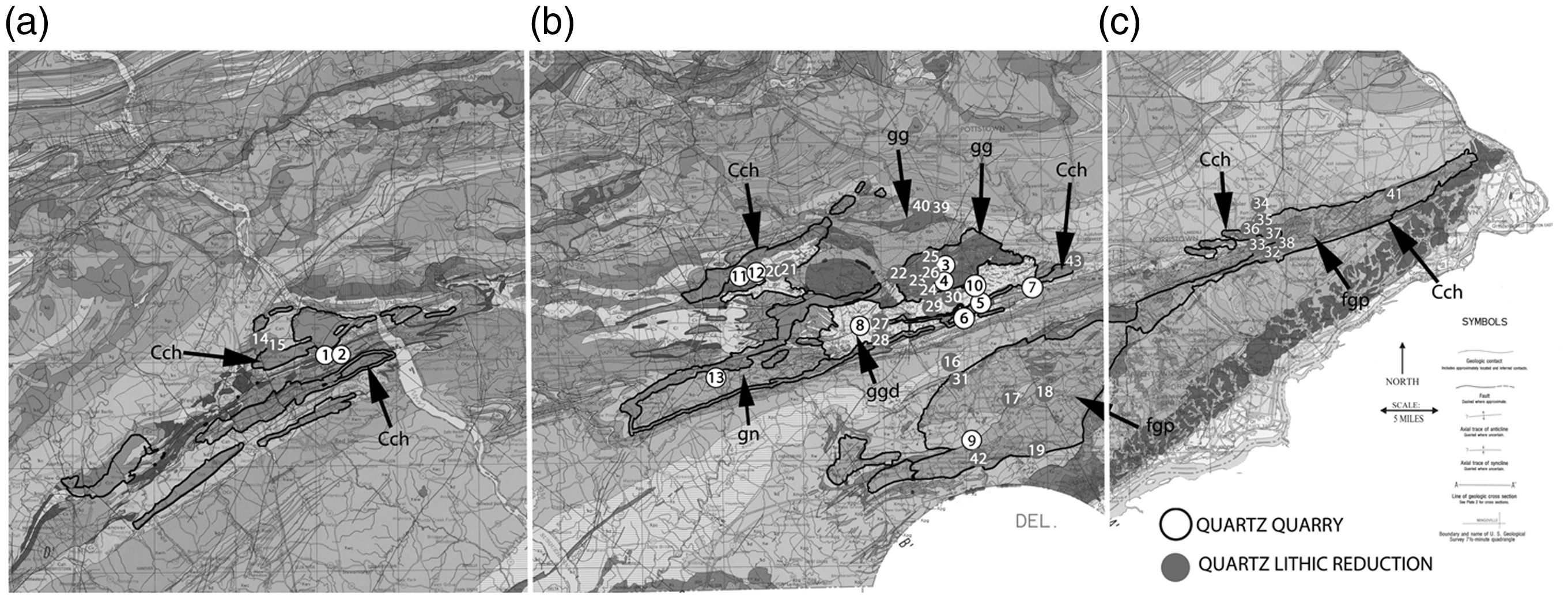
Geologic map of Pennsylvania (taken from Socolow, 1980) showing the locations of recorded quartz quarry sites and sites with quartz dominant assemblages. (a) Blow up of Section A from Figure 3. (b) Blow up of Section B from Figure 3. (c) Blow up of Section C from Figure 3.
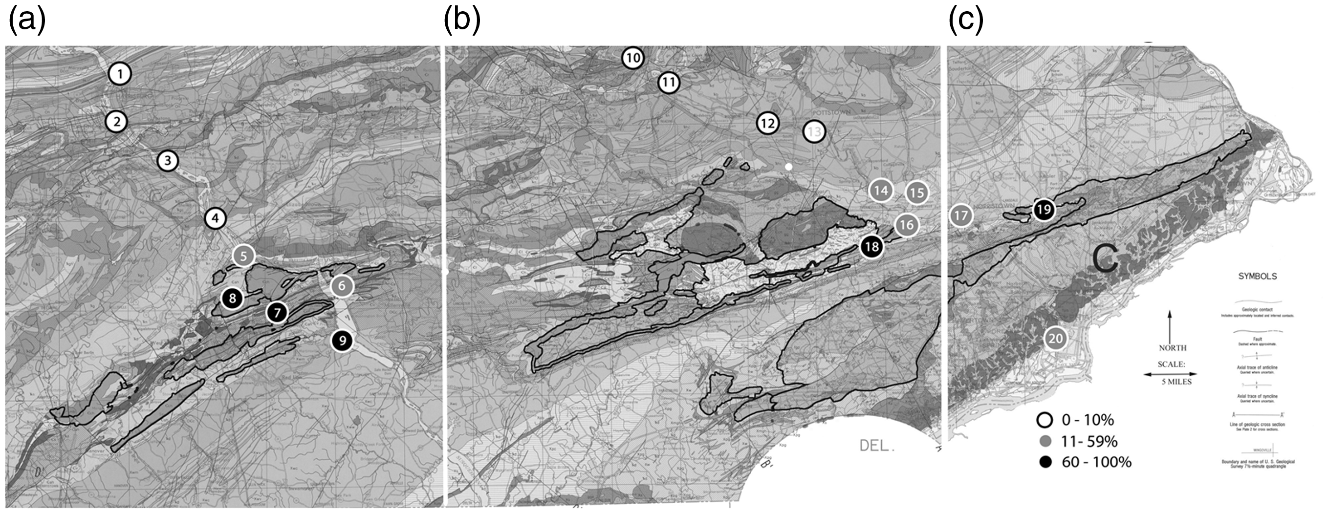
Geologic map of Pennsylvania (taken from Socolow, 1980) showing the locations of recorded sites with their relative percentages of quartz assemblages along sections of the Susquehanna and Schuylkill rivers. (a) Blow up of Section A from Figure 4. (b) Blow up of Section B from Figure 4. (c) Blow up of Section C from Figure 4.
Recorded sites (Figure 3) including quartz quarry sites and quartz dominant site assemblages.
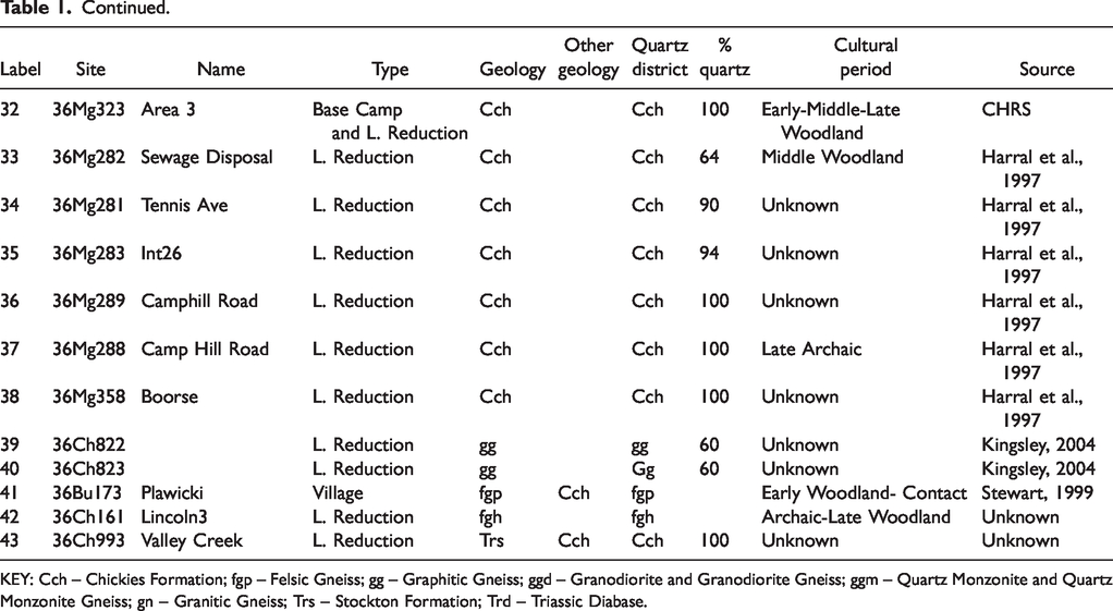
KEY: Cch – Chickies Formation; fgp – Felsic Gneiss; gg – Graphitic Gneiss; ggd – Granodiorite and Granodiorite Gneiss; ggm – Quartz Monzonite and Quartz Monzonite Gneiss; gn – Granitic Gneiss; Trs – Stockton Formation; Trd – Triassic Diabase.
Results
A search of the Pennsylvania Archaeological Site Survey files and archaeological site reports identified 13 potential quartz quarry/extraction type sites in Pennsylvania’s Piedmont (Figure 3; Table 1). No actual site of extraction or quarrying has been adequately investigated or precisely identified. Several professional archaeologists in Pennsylvania have suggested the location of quarry/extraction sites in proximity to quartz-dominant sites, but none of the suspected sources of quartz has been adequately documented. The hypothetical signature of a quarry-related site is an artifact debris field (i.e., large concentration of artifacts) comprised of early stage quartz artifacts (i.e., debitage, cores, and early-middle stage bifaces).
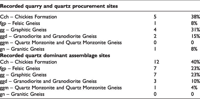
Of the 13 sites identified, eight were located in Chester County, two in York County, and three in Lancaster County. Five of the quarry sites (38%) appear to be associated with the Chickies formation (Cch), four (31%) were associated with granitic gneiss (gn), two (15%) with granodiorite gneiss (ggd), one (8%) with graphitic gneiss (gg), and one (8%) with felsic gneiss (fgp; Table 2). Eight of the potential quarry sites were archaeologically investigated, as described below.
Recorded quartz quarry and quartz dominant assemblage sites and their geologic formation percentage.
Site 36YO240 in York County was characterized as a quartz procurement and processing station and short-term hunting base camp utilized most intensively during the Late Woodland period (Hay and Hamilton, 1986: ii). A large quantity of quartz debitage and early stage bifaces was recovered. The quartz was determined to be of low quality and used predominately for the production of expedient tools. The source of the material was thought to be located close by. However, the quarry or extraction site was not investigated.
Seven prehistoric sites were discovered during studies in Chester County, Pennsylvania (Lewis et al., 2004). The sites include five lithic reduction and two possible quartz quarry type sites. All of the sites contain artifact assemblages with more than 90% quartz. One quartz quarry (36CH836/Ewing 1) was marked by the presence of a large recession/pit and an encirclement of a large quantity of early stage quartz artifacts. The pit appears to be a Hatch Class III type deep pit which was excavated by the Native Americans for the extraction of quartz.
The other quarry type site (36CH839/Ewing 4) identified during the survey noted above was represented by a large quartz artifact debris field. No pit was discernible at this locale, but the large quantity of early stage debitage and early to middle stage bifaces suggested that the extraction source—probably float deposits—is close by.
A quartz-dominant site (36CH721), in West Whiteland Township, Chester County, yielded nearly 4,000 artifacts, including 25 diagnostic tools (Geidel et al., 2002). Occupation extended at least from the Middle Archaic through Middle Woodland times, though the Late Archaic is best represented. The only feature identified at this site was a cluster of unworked pieces of quartz and quartzite, interpreted as a raw material stockpile. Site 36CH721 is located near outcrops of quartz associated with the Chickies formation. The site was interpreted as a quarry reduction station associated with a quarry, and other sites in the vicinity were identified as secondary reduction sites. Site 36CH721 provided most of the evidence concerning the proposed “Chickies Formation Quartz Procurement Archaeological District” (Basalik and Lewis, 2003).
A quartz quarry and workshop (36CH128) situated next to Upper Valley Creek in Exton, Chester County, contained exclusively quartz debitage, cores/core fragments, bifaces/biface fragments, retouched flakes, and a few projectile points (Catts and Siegel, 1997). Diagnostic artifacts indicated occupations dating from the Late Archaic through the Late Woodland periods. Two other sites located close by, 36CH332 and 36CH335, were also quartz-dominant. The investigators surmised that quartz cobbles and nodules, available in the sediments, were collected and reduced on site. Site CH128 is located immediately adjacent to the Chickies formation, which is the most likely source of the material.
The Joseph Lewis site (36CH859) in Chester County was located adjacent to a prominent ridge of the quartz-bearing Chickies geologic formation (Basalik et al., 2009). The prehistoric component to the Joseph Lewis site (36CH859) consisted of 5602 quartz artifacts, which represent over 99% of the assemblage. Within the assemblage, 39 early to middle stage quartz bifaces and 21 quartz cores were identified. It appears that the quartz-dominant site is closely connected to a nearby source of the material, that cited by the geologist Samuel Gordon (1922), who identified notable quartz exposures in the ridge named Diamond Rock Hill.
Site 36CH368, located along the West Branch of the Brandywine Creek, was characterized as a quarry-related procurement and lithic reduction site dating from the Late Archaic through the Late Woodland periods (Custer, 1991). Multiple occupations spanning this time period left evidence of both biface and core production. The core production appeared to be geared towards the manufacture of expedient tools which were used at nearby procurement/processing sites. The biface production was thought to be focused on the manufacture of replacement tools. Naturally occurring sources of quartz were observed close to the site, but the quartz quarrying or procurement process was not investigated.
The Woodward site (36CH374), a quartz-dominant site along the Brandywine Creek in Chester County, contained a large number of artifacts, including projectile points, which suggested a multi-component site occupied repeatedly during the Late Archaic period. Fifty-two percent of the 4325 recovered artifacts were quartz. The researchers claim that the quartz was “immediately available from the banks of the Brandywine Creek as well as from boulders on the ridge southwest of the site” (Rue, 1991: 136). Although the Woodward site is not an actual quarry site, it is a lithic workshop area located very close to the areas of quartz extraction or procurement. Unfortunately, the quartz quarry/extraction locales were not studied.
Quartz-dominant sites
The presence of quartz-dominant sites is a signature of quarry/lithic extraction activities, especially when observed in clusters. This category does not include the lithic scatter site, defined by Custer (1988) as a site with 50 or fewer flakes and a few bifaces. Portions of Lancaster County, for example, have numerous recorded sites of this type. Such sites do not reflect quarrying or quartz artifact production, but rather the movement of people associated with other settlement or subsistence pursuits. Eleven of the identified quartz-dominant sites were archaeologically investigated and adequate data were available to discuss these sites in some detail. Other sites labeled quartz quarries appear to have been collected and identified by avocational archaeologists and lack detailed information.
A total of 30 quartz-dominant type sites were identified in the search: 18 of them in Chester County, 7 in Montgomery, 2 in York, 1 in Lancaster, 1 in Delaware, and 1 in Bucks County (Figure 3; Table 1). Twelve (40%) of the quartz-dominant sites appear to be associated with the Chickies formation (Cch), 7 (23%) with felsic gneiss (Fgp-Fgh), 7 (23%) with graphitic gneiss (Gg), 3 (10%) with granodiorite gneiss (Ggd), and 1 (4%) with quartz monzonite gneiss (Ggm) (Table 2). Only seventeen of the thirty sites were found to have adequate archaeological data for descriptive comparison. Therefore, only these sites will be discussed in the following section.
The Sherman Street 1 site (36YO366) in York County appears to be an early to middle stage quartz processing station (Lewis et al., 2005b). The site yielded a total of 1,770 quartz pre-Contact artifacts (99.5% of the assemblage) distributed in a large quartz artifact debris field. No diagnostic artifacts or carbon were recovered, so the site cannot be dated. The quartz-dominant site lies within the Piedmont Physiographic Province and close to the Chickies geologic formation.
The majority of the quartz from the Sherman Street 1 site (36YO366) was of very low quality. Quartz of comparable quality and a similar reduction sequence was found at four other nearby sites—36YO240, 36YO234, 36YO235 and 36YO236—which produced diagnostic artifacts implying use during the Archaic and Late Woodland periods (Hay and Hamilton, 1986). Given the proximity of these four sites to the Sherman Street 1 site (36YO366), it is likely that the same source of quartz was exploited. The reduction sequence described above for 36YO240 may therefore also apply to 36YO366.
A survey in the Pennsylvania Piedmont resulted in the discovery of seven prehistoric sites: six lithic scatter sites and one suspected base camp (36MG281, 36MG282, 36MG283, 36MG288, 36MG289, 36MG358, and 36MG323; Harral et al., 1997). All of the sites are comprised primarily of quartz artifacts. The source of the quartz appears to be the Chickies formation. The proportion of quartz in the site assemblages drops off precipitously with distance to the Chickies formation. Materials such as jasper, chert, and argillite become the dominant lithic materials with greater distance to the north and east of the suspected source of the quartz.
Site 36YO59 lies along Codorus Creek within the Conestoga Valley section of the Piedmont Physiographic province in Manchester Township, York County (Lewis et al., 2007). The site yielded a total of 603 prehistoric artifacts, 432 of which were quartz, representing 74% of the assemblage. Diagnostic points documented a span of use from the Archaic through the Late Woodland periods. Given the proximity of 36YO59 to the quartz-bearing Chickies geologic formation, the location of this quartz-dominant site seems linked to a nearby source of the material. Again, the distribution of rhyolite-dominant sites indicates that quartz utilization decreased precipitously with distance to the quartz sources and the presence of barriers like Codorus Creek.
Two prehistoric sites (36CH902 and 36CH903) adjacent to Beaver Creek, a tributary of the Brandywine Creek in East Brandywine Township, Chester County, Pennsylvania were studied by Lewis and Ruth (2012). A total of 108 artifacts were recovered from 36CH902, while 36CH903 yielded 189 artifacts, of which 181 were quartz (95.8% of the assemblage). The artifact assemblage from 36CH0903 was comprised primarily of lithic debitage.
Michael Stewart (1999) investigated the Indian Town of Playwicki (36BU173) during the early 1990s. The site is located near Langhorne, Bucks County, in the eastern part of the Pennsylvania Piedmont uplands. The archaeological investigations uncovered a number of quartz artifacts which apparently was acquired from local sources of the raw material, such as the felsic gneiss or Chickies formation, both of which are located nearby.
Quartz artifact distributions with sites and geology
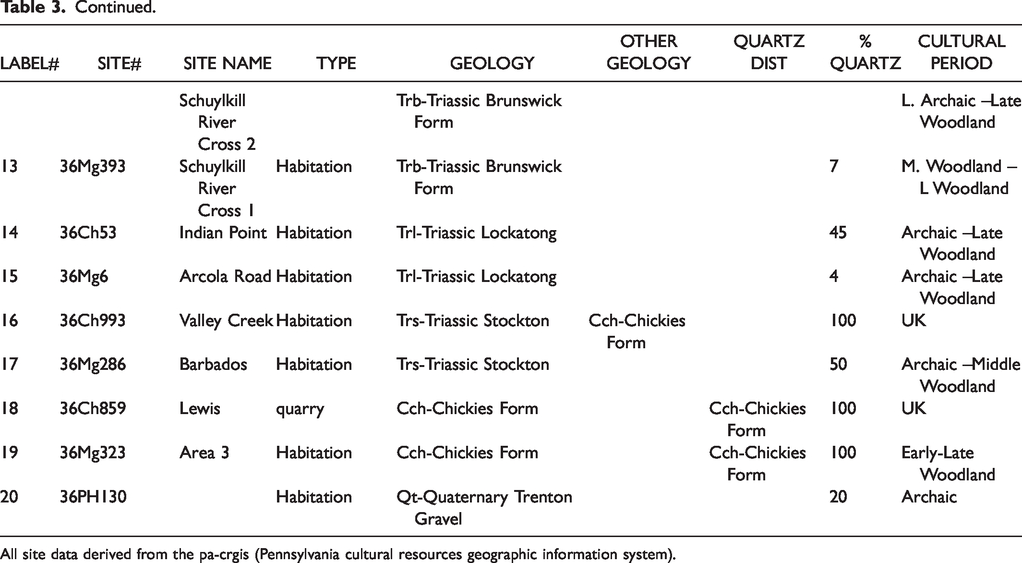
Sites with recorded lithic percentages were identified in the vicinity of the two major river systems, the Susquehanna and the Schuylkill, which cross the Ridge and Valley and Reading Prong physiographic provinces into the Piedmont. The select sites were grouped according to the relative lithic percentages of quartz (0–10%, 11–59%, and 60–100%). The cross section of the region following the two major rivers shows a marked increase with quartz site assemblages in the vicinity of quartz-rich bedrock sources. The quartz-bearing geologic source areas contain the highest quartz site assemblages. The utilization of quartz also sharply decreases with an increase in distance from the source (Figure 4; Table 3).
Cross section of site quartz percentages along selected segments of the susquehanna and schuylkill rivers (Figure 4).
All site data derived from the pa-crgis (Pennsylvania cultural resources geographic information system).
Summary and discussion
This study focused on identifying specific geologic sources for prehistoric quartz tool stone in the Piedmont Physiographic Province of Pennsylvania by tracing the patterning of recorded archaeological sites with quartz-dominated assemblages with respect to quartz-rich rocks such as the granitic, graphitic, felsic, and granodiorite gneisses and other quartz sources such as the Chickies geologic formation. These geologic formations are the most likely sources of the quartz used in prehistoric quartz tool manufacture. It’s pertinent at this point to discuss aspects of quartz procurement along with interpretations of prehistoric social organization as it relates specifically to the southeastern Pennsylvania region. An understanding of the settlement-subsistence organization through time is essential for interpreting the procurement of quartz tool stone. It is the contention of this author that cultural groups within this region were engaged in high residential mobility and a hunter-gatherer subsistence for 10,000 or so years without much change to the social organization or technological base (Lewis, 2019), as discussed below.
Most of the identified quartz dominant sites in this study displayed no evidence of quarrying. However, the sites did contain a very high percentage of early to middle stage quartz artifacts including debitage and bifaces. Additionally, the quartz artifacts were often found in large debris fields which potentially can identify quartz extraction areas. This site type corresponds to Katz et al.’s (2016: 42) Type 2 quartz industry site: procurement site and workshop, with dense debitage and no evidence of quarry pits.
The actual quartz quarry or extraction areas have generally not been identified because of a number of factors. Many of the extraction locales are suspected to be small in size and presently obscured by soil and vegetation. Some may have been destroyed by modern development or are inaccessible due to private property issues. A major problem for CRM archaeological investigations is the limited area of study imposed by the extent of project effects.
The type of quarry/extraction site is linked to the quartz-bearing geologic formation. The Hatch (1993: 28) quarry classes I-III appear to be associated with graphitic and granitic gneiss formations. A good example of this is site 36CH836, which has been previously discussed. This site provides evidence of a Hatch Class III quarry site or the Type 1 quartz industry site of Katz et al. (2016: 42) (a procurement site with quarry pits and workshop activities). Quartz can be found in great abundance in some of these geologic areas. Large quartz boulders have been observed protruding through the surface similar to the float deposits found with jasper tool stone in portions of the Hardyston formation. Depending on the occurrence of quartz (i.e., accessibility, quantity, volume, and knapping quality), the exploitation of that material may have included surface collections or deep quarry pits. Class I and II quarry types (Hatch 1993: 28) would be anticipated in most of the quartz bearing formations. Many of these locales, including the Chickies formation, are situated in relatively steep rock exposures where vein quartz is found in a restricted distribution. These source type areas would not be practical for intensive quarrying involving deep or even probably shallow pits.
In terms of temporality, quartz was used by all of the Native American cultural groups who inhabited this section of the Middle Atlantic. Some scholars have claimed that quartz utilization peaked during the Late Woodland period, perhaps as a result of tribal territorial restrictions and the need to use local resources. Although some evidence points to peak usage during the Late Woodland period, the overall evidence suggests that Native American groups of all time periods made use of quartz.
There has have been numerous observations and interpretations regarding culturally determined patterns of preferred tool stone use. However, the overall observed differences in lithic composition from site to sites in southeastern Pennsylvania appear to be directly related to tool stone source access to specific site locations (Lewis, 2019). In general terms, there does not appear to be a preferred lithic type, but instead a variety of available lithic type or types which the Native American inhabitants opportunistically made use of during their group movements. Of course, there are some notable exceptions to this rule, especially concerning the Late Archaic/Transitional period use of jasper, metarhyolite, and argillite (Stewart, 2015: 11–12). Additionally, a site’s tool stone composition generally reflects the geographic proximity to these lithic resources: the higher the percentage of quartz in a site assemblage, the closer the source, and vice versa.
Many of the quartz-dominant sites in the Piedmont represent repeated low-intensity quarrying and lithic reduction activities that cumulatively produced large quantities of chipping debris, rather than the results of a few large-scale quarrying efforts. Such sites are most likely the result of repeated occupations that produced a palimpsest effect, which can mimic the appearance of a large, intensive occupation.
The Native Americans inhabitants were engaged in high residential logistical mobility from the beginning to practically up until the Contact period. This pattern is evident in the context of hundreds, if not thousands, of lithic debris sites in eastern Pennsylvania. Almost every identified pre-Contact archaeological site consists of a scatter of lithic debris, usually consisting of 80–100% debitage, with 20% or fewer non-debitage artifacts, comprising an assortment of projectile points in varying stages of intactness, bifaces in varying stages of production, some cores, some scrapers, and some fire-cracked rock (FCR). Very few features are found at most of the sites and the features which are found are usually limited to a few possible post molds and some possible hearths. A square meter of soil at these various may contain 10 – 200 artifacts (mostly debitage) and with the majority of sites comprising recoveries on the smaller end. An economy based on hunting, gathering, and fishing would require an occupational pattern of transhumance to accommodate the subsistence requirements of these groups.
Site locations were determined by subsistence pursuits encompassing plant and animal resources along with useable stone for tool production and firewood for cooking and heating. Predictable vegetal resources in old growth forests associated with the oak-chestnut biome would have included the mast produced from oak, chestnut, hickory, walnut, and beech trees in the fall (Messner, 2011). Chestnut, oak, and hickory trees would have been widely distributed throughout the Middle Atlantic. The presence of these resources undoubtedly encouraged the establishment of nearby campsites. The most predictable and abundant faunal resource may have been the anadromous fishes (Becker, 2006; Schindler, 2008). According to Becker (2006) and Schindler (2008), a wide variety of anadromous fish may have been available to the pre-Contact populations. The locations and timing of these runs would have influenced the selection of sites by aboriginal groups and resulted in seasonal reoccupation of these areas.
The notion of large village sites that allegedly existed during the Contact, Woodland, and or earlier periods in southeastern Pennsylvania has yet to be verified in the archaeological record. Additionally there is little evidence to support the notion of agriculturally based cultural practices in this region. The Native Americans, including the Lenape and the Munsee, were hunter and gatherers who grew some supplemental maize, beans, squash, and perhaps sunflowers (Lewis, 2019).
In terms of population estimates, Stewart (1995) with his work on the Indian Town of Playwicki, a Contact period site in Bucks County, Pennsylvania, suggests that communities may have consisted of 30 or more people. This number is consonant with Custer’s (2013: 143) estimates for the typical Woodland period village where the largest number of people living together in one place at one time would have been 20 – 25. Many scholars provide estimates of Contact period Native American population at 8000 – 12,000 for the combined Munsees and the Lenapes (Soderlund, 2015: 17). This estimate would imply approximately 400 small base camps distributed over the Munsee/Lenape territories during any one time period. Estimates for global hunter-gatherer density project one person per square mile as the ideal (Wholey, 2015: 112). This density projection fits fairly well with the population estimates of 8000 – 12,000 for the combined Munsees and the Lenapes. Interestingly, the population calculations for an assumed agriculturally based cultural system, as in Soderlund’s interpretation (2015: 17), match the hunter-gatherer population estimates. The hunter-gatherer population interpretation appears more consistent with the archaeological data. It appears that a hunting and gathering settlement and subsistence pattern, together with a tool stone procurement strategy involving opportunistic use of available sources, may account for the observations in the archaeological record for this region through time.
Future research
Future research should focus on identifying actual quarrying operations and classifying sites according to the typologies of Hatch (1993) and Katz et al. (2016), discussed above. There are many questions that need to be addressed when studying these lithic production systems: mining techniques, mining tools, the nature of quarrying artifact assemblages, the quality of mined material, labor investment, and trace element/chemical composition quarry signatures, to name a few (Abbott et al., 2001).
Future research should focus on constructing a geographical model of quartz procurement and transport that could aid in identifying actual quartz quarries or extraction sites. Differences in the quartz assemblages of sites would reflect stages within the lithic reduction continuum from extraction to manufacture and use. This data, with raw material sourcing, would in turn help to define the foraging/collecting territories of the quartz-utilizing groups (i.e., the lithic production system).
Pennsylvania Piedmont quartz is ubiquitous, but its procurement was not random. Careful study of the full range of sites evidencing quartz extraction, processing and use can help to reconstruct the ways that the prehistoric inhabitants of southeastern and south-central Pennsylvania obtained and used this material.
Footnotes
Declaration of conflicting interests
The author(s) declared no potential conflicts of interest with respect to the research, authorship, and/or publication of this article.
Funding
The author(s) received no financial support for the research, authorship, and/or publication of this article.