



Abstract
‘Methods’ and their devices have been conventionally viewed as the means through which the move from world to representation (and back again) might be reliably performed. An alternative view, perhaps most clearly exemplified by the post-ANT empirical programme of ‘material semiotics’, sees methods and devices as integral to the ways particular ‘realities’ are enacted in practices of inscription and intervention. Drawing upon this latter work, the present paper examines the role of satellite images, GIS and GPS data and devices in the methods utilized in the location, identification and classification of ‘illegal deforestation’ in Brazilian Amazonia. Here we witness how efforts to render ‘deforestation’ into a stable object of knowledge, singular and coordinated, are countered by attempts to render it multiple and irreconcilable as methods and devices become entangled in the conflicts and antagonisms of social life.
In his Origin of German Tragic Drama, Walter Benjamin claimed that a key characteristic of philosophy is ‘that it must continually confront the question of representation’ (1998 [1925]: 27). Indeed, we might say that never-quite-resolved questions of representation continue to beset the modern world. Drawing upon an ethnographic investigation of how satellite images and their associated inscriptive methods and devices figure in the study, detection and prosecution of ‘illegal deforestation’ in Brazilian Amazonia, we seek to explore how ostensibly philosophical questions concerning representation come to be confronted by participants as pressing practical problems.
Contemporary representational ‘economies of convenience’ cater to the ever-growing hunger ‘to make transparent what is opaque, to make present what is remote, and to manipulate what is resistant’ (Cooper, 1992: 255; Lilley et al., 2004). In this sense ‘the diverse practices subsumed under the notion of organizing are but various manifestations of the basic operative schema of representation: something for something else’ (Kallinikos, 1990: i, our emphasis; Castoriadis, 1987). Questions of representation therefore tend to boil down to practical (and at the same time political; e.g. Latour, 1993) problems of substitution. They create a presence for what is absent by substituting in its place ‘something else’ (typically an inscription of some kind) that is ontologically distinct from the object, state, event, etc., being re-presented. Re-presentation, therefore, can be said to both re-create presence and, at the same time, testify ‘to absence by tracing and retracing [an] ever elusive presence’ (Taylor, 1984: 82). This (in)ability of re-presentations (whether indexical or symbolic) to fully occupy the space relinquished by their originals is itself memorably represented in René Magritte’s Treachery of Images (the famous 1928 painting of a pipe-that-is-not-a-pipe; see Foucault, 1973). Given that maps have long functioned as Occidental representational archetypes (Turnbull, 2003: 93), this ‘treachery’ is commonly described as ‘the map–territory problem’ (e.g. Bateson, 1972) – after Korzybski’s (1931) oft-quoted dictum ‘the map is not the territory’. ‘When we map, we miss’ (Clegg and Hardy, 1996: 676). In Bateson (1972), for instance, the move between map and territory is characterized by infinite regress: Operationally, somebody went out with a retina or a measuring stick and made representations which were then put upon paper. What is on the paper map is a representation of what was in the retinal representation of the man who made the map; and as you push the question back, what you find is an … infinite series of maps. The territory never gets in at all. (p. 460)
Latour’s (1999) study of ‘Circulating Reference’ seeks to bridge the gap between philosophical and pragmatic accounts of representation. Latour describes how researchers conducting fieldwork in the Amazon perform the move from savannah soil to scientific article as a sequence of seemingly small, eminently reasonable substitutions: plants and soil become plant and soil samples; samples are assigned numerical values and become sets of measurements, etc. In the course of this circulation, things routinely become signs and signs things: ‘the earth becomes a cardboard cube, words become paper, colors become numbers, and so forth …. An essential property of this chain is that it must remain reversible … allowing for travel in both directions’ (Latour, 1999: 69, our emphasis).
Whilst there is much to commend in Latour’s analysis, what tends to remain obscure (but becomes more evident in his [2004a, 2010] discussions of the accomplishment of legal re-presentation, for example), is the socially and culturally situated nature of what is to count as a ‘reasonable’ substitution. This question of how the ‘reasonableness’ of specific referential claims is demonstrated has been a central concern of ethnomethodological examinations of scientific, legal and administrative practices (Atkinson, 1978; Garfinkel et al., 1981). Garfinkel’s (1967) study of the work of the Los Angeles Suicide Prevention Centre (SPC), for instance, shows how a relationship of adequation between sign and referent is ‘reasonably’, ‘realistically’ and ‘practically’ accomplished in the course of determining actual cause of death in the cases referred to it by the Coroner’s Office. The SPC quest to make present the intentionality or otherwise behind the act of dying, Garfinkel (1984 [1967]: 17–18) notes, typically begins with a set of remains: the body and its trappings, medicine bottles, notes, bits and pieces of clothing, and other memorabilia – stuff that can be photographed, collected, and packaged … rumors, passing remarks, and stories …. These whatsoever bits and pieces … are used to formulate a recognizably coherent … professionally defensible, and thereby … recognizably rational account of how the society worked to produce those remains. (emphasis in original)
It is clear that ‘legal’, ‘botanical’, ‘pedological’, etc. inscriptions may perform the connection between what is absent and what is at hand in very different, possibly irreconcilable, ways. Annemarie Mol (2002) has argued that it is not merely a question of how different vehicles and practices of representation generate different views of the same object. Such objects are multiple not because they amount to different re-presentations of the ‘same thing’, as Mannheim (1936: 97) once postulated, but rather by being enacted in different ways. Whatever we might mean by ‘different’ practices of ‘representation’ (substitution), therefore, can equally be understood as integral to ‘different’ performances of the ‘object’ they ostensibly share. In what follows we set out to explore these issues by taking up the Latourian question of ‘circulating reference’. The ‘circulation of reference’ is here viewed not as an orderly sequence of relatively smooth passages from world to inscription and back again, but as an unfolding series of social dramas (Turner, 1987). The focus of the investigation is how exactly satellite images and GIS data of Amazonian deforestation ‘work’ (or fail to do so) in making distant sites and events present, and how are they worked upon.
Satellites are often thought to occupy a kind of Archimedean vantage point from which any earthly subject of inquiry may be objectively perceived. Satellite images, in appearing to be exempt from the infinite regress which, according to Bateson (1972), plagues the move from map to territory, are thus ideal typical examples of Heidegger’s (1977: 134) Weltbild: a world rendered ‘as a picture’ (our emphasis). ‘[I]n the age of Google Earth and GPS’, we are told, [t]he new assumption is that any map – if it is a proper map – will be merely a sort of scientific record of what is there on the ground, as seen by a satellite and adjusted to a particular scale. (Malcolm, 2012) The legal Amazon and the ‘deforestation arc’, the main frontier of deforestation.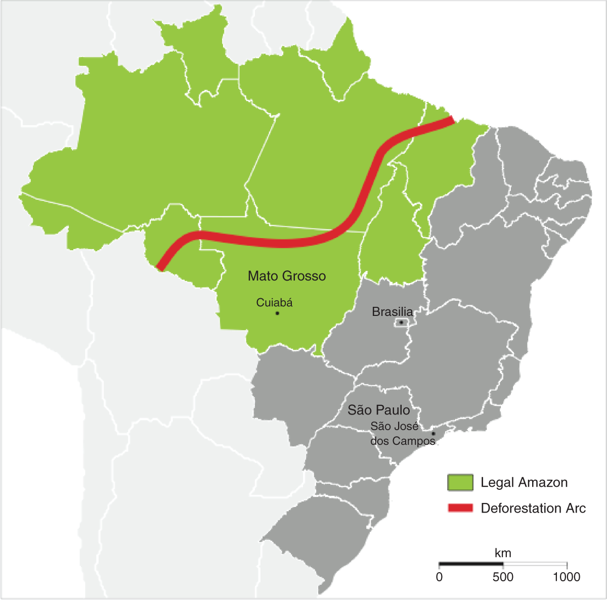
Deforestation as Sovereignty, as Development, and as an Environmental Crime
Brazil’s share of the Amazonian rainforest covers an area of 5 million km2. Up until the 1960s the region had been left relatively untouched. Following the 1964 military coup, however, the settlement of the region became a government priority. The regime became increasingly preoccupied with the possibility that foreign encroachment might lead to loss of sovereignty over Amazonia (the terra nullius argument). In order to fill in the region’s ‘demographic emptiness’ the regime initiated a major internal colonization project incentivized by road building and subsidies for agricultural activities. These measures (‘clearance as sovereignty’), and the subsequent re-definition of the Amazonian rainforest as a yet-to-be exploited resource (‘clearance as development’), initiated the process of large-scale deforestation which continues today (Fearnside, 2005; Hayes and Rajão, 2011). During this period the use of remote sensing methods such as RADAM (a 1970s Radar in the Amazon project), and satellite images acquired (from the US Landsat satellite) by the newly (1971) created Brazilian space research institute INPE (Instituto Nacional de Pesquisas Espaciais), primarily aimed at ‘providing information to improve the process of occupation of the Amazon’ (Novaes et al., 1980: 10). As a senior scientist and ex-director of the Amazon project at INPE recalled in an interview: You received subsidies from the government to carry out a certain [forest clearing] project. But how to make sure whether you have cleared the area or not? Did the [size of the] clearing match the project? Did it match the number of hectares [of clearing] that you have stated in the project documents? It [INPE research] started in order to make sure that, from a legal point of view, the area was indeed being cleared. Of course, there was also an illegal aspect to it when they deforested and then simply abandoned the area.
By the late 1980s, in response to growing national and international pressures to protect the Amazon – pressures aggravated, according to our INPE interlocutors, by Space Shuttle pictures of huge fires consuming the rainforest – Brazil changed its official policy. In 1988 a new constitution re-defined the Amazon as a ‘national patrimony’ (Brasil, 1988: Art. VI, §4°) and, implicitly, re-defined (unauthorized) clearance as an ‘environmental crime’ (‘deforestation’). A year later, in order to strengthen the law enforcement arm of the new environmental policy, a number of different agencies were merged into IBAMA (Instituto Brasileiro do Meio Ambiente e dos Recursos Naturais Renováveis – Brazilian Institute of Environment and Renewable Natural Resources), the federal environmental protection agency (Brasil, 1989: Art. 44). A key mission of IBAMA is the enforcement of the forestry code, a set of laws and regulations which dictate inter alia that landowners are required to preserve a share of the native vegetation in every rural property – the so-called ‘legal reserve’.
Following the 1995 spike in reported deforestation rates, the legal reserve was raised from 50 per cent to the present (2012) 80 per cent. Thus, owners of properties located in the Brazilian Amazon rainforest region are currently allowed to ‘clear’ and use for economic purposes no more than 20 per cent of the area of their landholding. The uneasy compromises that such arrangements entail are reflections of the continuing salience of the different ways of defining and managing clearance/deforestation: ‘development’ vs. ‘environmental crime’. Deforestation, we might say, remains a ‘multiple’ object (Mol, 2002).
Against this backdrop, INPE has begun to play an increasingly important role in shaping knowledge about, and policies towards, the Amazon via the creation of PRODES (Programa de Cálculo do Desflorestamento da Amazônia), a satellite-based GIS (geographical information system) which since 1988 has produced reliable yearly deforestation figures of the Amazonian rainforest (Fearnside, 2005; Fuller, 2006). Despite the importance of the data generated by PRODES, access to maps with the location of deforestation had been historically highly restricted, a legacy of the ‘deforestation as sovereignty’ policies of the military regime which classified data concerning the Amazon as matters of national security. IBAMA therefore lacked full access to detailed deforestation data. This situation began to change in 2003 when Marina Silva, the newly appointed Minister of the Environment, instituted a change in data policy. This facilitated the publication of PRODES deforestation maps and satellite images on the internet free of charge. In the following year, INPE launched DETER, a new monitoring system which detects and informs IBAMA fortnightly of new deforestation in the Amazon.
Traditionally, IBAMA forest rangers, not unlike traffic wardens issuing parking tickets, were entrusted with the role of ‘witness to the act’. Accordingly, when a ranger issues a fine, that document already has the status of a ‘legal fact’. At the same time, the farmers and landowners have the right of appeal. On receiving the fine for ‘illegal deforestation’, farmers may present a defence to either the local or regional IBAMA director (depending on the value of the fine), which challenges on one ground or another the fine issued by the ranger (e.g. the ranger ‘issued the fine as a means of extorting a bribe’). As a local farmer put it in an interview: ‘Everybody knows that with some sweet talk and money they [rangers] can forgive anything’.
The local or regional IBAMA director therefore has to evaluate the merit of the defence and decide whether to annul the fine or reject the defence. However, it might be dangerous for directors to take upon themselves the task of judging landowner appeals since they could be accused of being part of the corruption scheme. Thus local directors often appeal to IBAMA’s own attorneys in regional offices or IBAMA headquarters for legal advice. If, acting on this advice, the landowner’s defence is rejected, the landowner can still launch a further series of appeals. Given the complexity and geographical distances involved, it is not surprising that often a case may take more than a decade to be settled.
With the introduction of DETER, the work of IBAMA now starts thousands of kilometres away from the rainforest, in São José dos Campos, where INPE scientists and technicians identify areas of deforestation in satellite images. When incoming satellite images have been processed and interpreted, and new deforestation locations identified, the information is forwarded to IBAMA headquarters. At IBAMA another team of technicians and scientists aggregate additional data to the DETER deforestation ‘polygons’ (e.g. Figure 6) which are then distributed via a restricted website to IBAMA’s Amazon bases. There the directors of law enforcement decide which areas should be given priority and select a set of ‘points’ to be checked. These points are then allocated to a group of IBAMA rangers who then take to the field in off-road trucks.
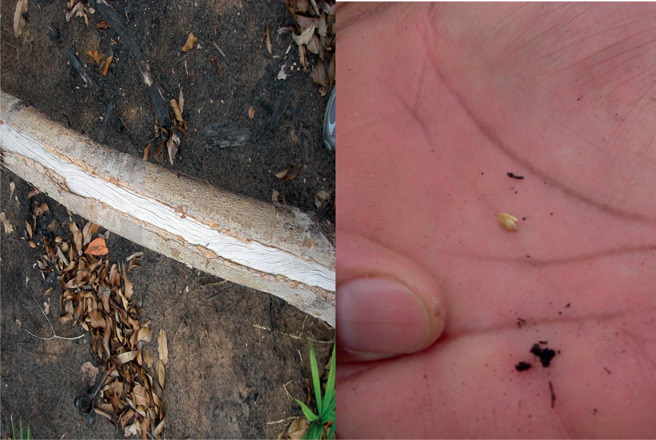
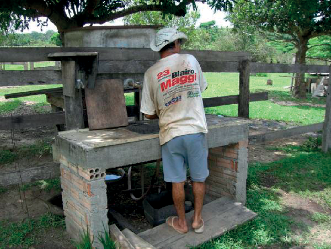
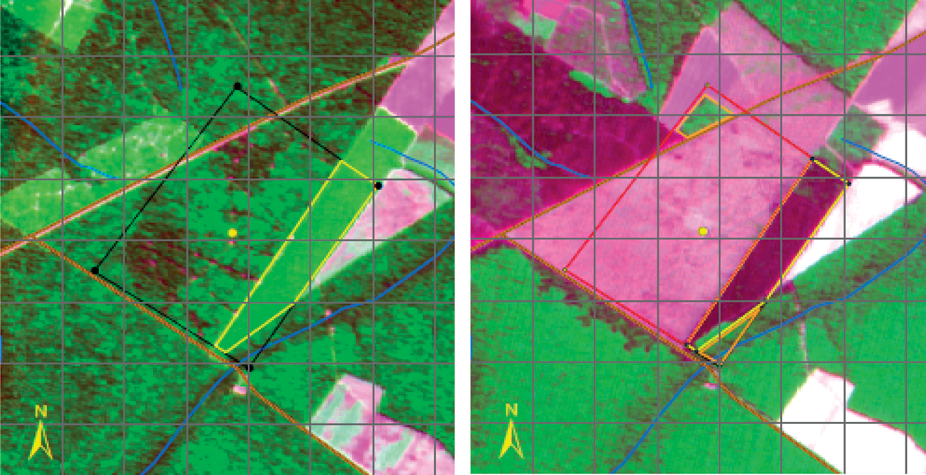
‘Valquíria’ using GPS and a DETER printout in order to establish the location of (the ‘right’) deforestation. João performing an inspection of the site. Representing ‘intentionality’. A local farmer interviewed by João. The map-image of the farm in 2004 (left) and in 2008 (right).

All the informants interviewed in the course of this research, from ex-ministers down to the rangers working in remote areas in the Amazon, agreed that the introduction of DETER and related technologies was a major gain. The ‘new eyes in the sky’ enabled an exponential increase in the number of IBAMA fines for illegal deforestation. Indeed, many farmers argued that today ‘you cannot cut down a tree without being caught by the satellites’. Therefore, even though other factors are also clearly at play, it is possible to give some credence to the government claim of a 60 per cent drop in the annual rate of (illegal) deforestation between 2006 and 2010 due to better data provided by the new technologies which in turn facilitated the escalation of IBAMA’s activities in Amazonia (Faleiros, 2011). Furthermore, officials commonly reported that the introduction of satellite technology had also, crucially, improved the quality of the fines imposed for illegal deforestation, that is to say their ability to withstand Latourian ‘trials of strength’. A senior attorney at IBAMA headquarters explained the importance of the new devices: The effectiveness [of IBAMA’s work] was really low. After we started to indicate clearly the author of the crime and its exact location with GPS in the notices of infraction, the situation has improved a lot …. Now we have notices of infraction that are much better informed: with clear reference to the type of illicit activity and the precise size of the area – which is directly proportional to the value of the fine.
To accomplish this, however, the representation (the satellite image) needs, as it were, to ‘return’ to its original. For this purpose, it is necessary for the researcher to also travel from INPE’s laboratories and Brasília’s corridors of power to the Amazon and study the practices of the forest rangers as they go about their everyday work.
Establishing ‘Location’
The local offices of IBAMA are housed in somewhat ramshackle buildings, a world away from the concrete and glass architecture of its Brasília headquarters. One of these offices is in Sucupira, 1 (normally) a 12-hour bus ride on a bumpy road from the state capital – ‘the end of the world where nobody wants to go’, as one of the rangers remarks. At the same time, what strikes an outsider walking into an IBAMA Amazon office is the sheer number of computers. If it were not for the many confiscated chainsaws and the stink of gasoline, the rangers’ cubicles could have been taken for those of typical Euro-American ‘knowledge workers’. Sitting in front of these computers the rangers are, in fact, ‘getting ready’ for the field. Among them is ‘César’, the most technologically adept ranger in the office. In the course of his Master’s in Ecology he worked extensively with different geo-technologies, including satellite images and geographic information systems. He is editing in ArcGIS (a popular GIS software suite) the series of ‘deforestation polygons’ provided by DETER, which have been selected by ‘Bosco’ (the local law-enforcement coordinator). Using software similar to ArcGIS, INPE scientists in São Paulo analyse satellite images of the Amazon and every fortnight identify ‘land use changes’ – the technical jargon for deforestation. A visible difference between César’s desk and the desks of the scientists shadowed at INPE is the printer and the GPS devices connected to his computer. As printouts on individual A4 sheets, digital representations of deforestation become ‘immutable mobiles’ (Latour, 1987) that can be carried around by the rangers in the muddy roads of the Amazon without ‘deformations’, without (mis)leading them to the ‘wrong’ deforestation. By uploading the geographic coordinates of the centroids (i.e. barycentre of a plane figure or two-dimensional shape) of DETER’s deforestation polygons into their GPS devices, rangers will have to match the representation printed on a piece of paper to a particular swathe of ground.
After two hours of preparation, César hands over the folder with the DETER points, and the team – which includes among others ‘Valquíria’, a young analyst, ‘João’, an old-school ‘technician’, and three National Guard soldiers for protection – embarks in three trucks for the week-long trip. The ‘technicians’ are the older generation of rangers and tend to be in their 50s or 60s. Many of them were ‘inherited’ when the Department of Forestry was absorbed by IBAMA in the 1980s and lack higher education. They do not as a matter of course have many dealings with computers, and many of them have difficulties using GIS or interpreting satellite images. Nevertheless, and despite being caught on the wrong side of the digital divide, the technicians’ forest skills – such as the ability to identify different types of wood – make them invaluable. The ‘analysts’, by contrast, typically have degrees in subjects like forestry engineering, biology or agronomy. As such, some of them have been working with GIS and satellite images since university and are therefore at home with such devices.
At the end of the week, the truck’s odometer shows we have travelled 2031 km on unpaved and muddy tracks. We have visited 14 DETER points, carried out three inspections of embargoed areas and fined four trucks for transporting wood illegally. What follows is an account of a typical DETER point inspection which took place on the third day.
After getting lost twice and asking a local farmer for directions, we finally reach the designated location at about 11:00 hrs. ‘Is this the point of DETER?’ asks João, ‘Yes’, confirms Valquíria, looking at the GPS, ‘That’s great! We are not too far from the centroid’. This is crucial, because in this way rangers reassure each other that they are in the location of the right deforestation. In other words, that this is the point that the law enforcement director has instructed them to check and not any other of the dozens of deforested areas we have passed (Figure 2).
Not all rangers are happy with this digitally mediated way of working. Old hands argue that they would much prefer the traditional method of doing a ‘fine comb’, checking property by property, instead of only going to the points pre-established by Bosco. On the other hand, by taking the choice of where and what to inspect away from the rangers, the new digitally-based methods yield results that are more resilient against legal challenges. As rangers often point out, a typical strategy used by lawyers when challenging the fines levied against their clients is to call into question the ‘good character’ of the ranger. In the wake of a long line of corruption scandals involving IBAMA rangers it is not uncommon for a lawyer to argue that the fine imposed for deforestation was in fact part of an extortion attempt by a corrupt ranger against honest hard-working farmers. Thus the delegation of the decision to inspect a particular farm to DETER helps defuse a potentially confrontational encounter: the initiative behind the inspection originates not with the rangers themselves but rather with the satellites – unbiased heavenly beings, serenely floating above earthly matters.
Establishing ‘the Act’
After reassuring each other that we are in fact in the midst of the ‘right deforestation’ (the referent), the rangers drop from the truck and start examining the desolate landscape of burnt trees and ashes. ‘Look at the shit that this guy has done in this area’, says Valquíria in a sad tone of voice. We drop from the truck to take a closer look at the clearing. João walks along looking at the burnt logs. He kicks a log to see what is underneath and picks something up from the ground. As he explains, he is trying to find out ‘what happened here’. In doing so, João is drawing upon hard-earned skills developed by rangers in the days before the introduction of DETER and its associated inscriptive devices.
This would explain why it is the technician João, and not the analyst Valquíria, who is taking the lead. By examining the ground and the trees, João highlights to Valquíria the broken bark of the surviving trees and how they are bent in the same direction. For João this indicates that the owner of the land used a correntão, a heavy iron chain pulled by two tractors in order to break the vegetation and increase the effectiveness of the fire. He also points to grass seeds on the ground, which indicates that the aim of the landowner is to convert rainforest into cattle pasture (Figure 4). Meantime, he is also coding these observations into the terminology used by the rangers. In this way the visually messy scene of the dead forest becomes a series of keywords in Valqúiria’s notebook: ‘correntão’ and ‘pasture’. Not unlike the way Garfinkel’s (1967) SPC and Atkinson’s (1978) coroners might write in their reports the word ‘suicide’ after analysing the remains of the ‘body and its trappings’, it enables rangers to formulate an account of how ‘deforestation’ ‘really-for-all-practical-purposes-happened’ (Garfinkel, 1984 [1967]: 13–14) in the legal documents that will follow in the wake of the inspection.
This painstaking investigation might appear excessive given the size and apparent ‘self-evidence’ of the deforestation in front of us. Yet, as soon becomes apparent, this collection of evidence is central to the establishment of deforestation as a (legal) fact. Whilst fires have been prohibited for decades now, farmers and landowners still conduct slash-and-burn clearances in their properties and, when questioned, claim that the cause was an ‘accidental’ fire of unknown origin. Therefore, rangers require the means for re-presenting the human intentionality that ‘lies behind’ ‘what happened’. They thus use digital cameras to register the correntão scars and the presence of the seeds, and begin to formulate an account that rules out the ‘accidental’ nature of the clearing. Nobody commits considerable resources in tractors, chains and (probably) an airplane to distribute the seeds by ‘accident’. This particular clearing, in this particular location, has to be the result of an intentional premeditated act.
Establishing ‘Agency’
After spending an hour on site we are back in the trucks. Even though the location of, and intentionality behind, that specific deforestation have now been established to the rangers’ satisfaction, these traces still need to be tied to a specific person – the agent of the illegal act. Trial and error leads us to the gates of a nearby farmhouse, which in João’s judgement may be connected to this particular deforestation. The rangers drop from the truck, while the soldier stays inside the vehicle. He has learnt from previous visits that his presence makes farmers uneasy, and the work of the rangers difficult. We proceed towards the gates and João shouts, ‘Hello! Anyone there?’ From a little house comes a short thin man, wearing an old T-shirt from the political campaign of former Mato Grosso governor Blário Maggi (the world’s biggest soybean producer). The farmer (who is manifestly not the owner of the farm) greets us and invites us to take a seat on the patio. João, the old ranger, does the talking, while Valquíria discreetly takes notes:
Ranger: Nice farm you have here … Well-fed animals I can see. Farmer: Yes … the patrão [boss] buys only white zebu cattle. They grow well here. Ranger: We are here doing some inspections in the region, and we passed by an area where they appear to be making pasture. Is it from this farm? Farmer: Yes, it is …. The patrão has brought some tractors for the correntão. I also saw an airplane … Ranger: Airplane for the seeds? Farmer: I think so. Patrão order I [sic] to go there and do the fence for the pasture. Ranger: Ah, ok … What is the name of your patrão? Farmer: It is Dotô
2
António, from Tapira, which is not far from here. Ranger: Do you remember his full name? Or have any documents about the farm here? Farmer: Not really. But there everybody knows him. It is the second house just after the main square.
In the short conversation excerpt reproduced here, the rangers seek to accomplish a number of objectives. First (1–2), with friendly small talk the ranger opens the way for subsequent questions concerning the farm. Second (3–8), the ranger offers an innocent, mundane account of what is being done on the property and attempts to elicit confirmation from the farmer concerning the relation between the detected deforestation and the farmhouse. Put differently, the ranger seeks confirmation that the deforestation in question occurred within the boundaries of the farm of this specific farmhouse, and not in a neighbouring farm or in ‘no-man’s-land’, as a lawyer might later argue. Note, however, that the ranger does not refer to the deforestation in terms of its legal-scientific status: new, potentially illegal, deforestation as identified by DETER. Instead, the ranger refers to ‘making pasture’, a term used by farmers together with the more general phrase ‘opening the farm’. Finally (9–13), the ranger attempts to obtain the full details of the farm’s owner, again using the same ‘rural language’ as the farmer. In a similar manner to Garfinkel’s (1967) SPC workers, rangers seek to establish the relation between the act of deforesting a specific area and a specific farm (and thus a specific perpetrator) that will withstand any legal-scientific ‘trials of strength’ (Latour, 1987) to come.
On the basis of the information provided by the old man, Valquíria managed to identify the owner of the farm and hand him a notificação (notification) – not the auto de infração (fine for illegal deforestation). The notificação is merely a request for more information from the farmer and refrains from making any accusations concerning the committal of crime.
Inscription as a Constitutive Achievement
It was later, during a subsequent visit to Sucupira, that the full significance of the various inscriptions performed by the rangers started to become apparent. Rangers usually alternate between a week on the field, ‘doing DETER’ amongst other types of inspection, and a week in the office, doing what would appear as a regular bureaucratic job. After coming back from the field it is considered good practice to methodically combine the various pictures, observations, GPS coordinates and other such inscriptions into a single computer folder, and write a fieldwork report which establishes (however provisionally) the relation of these inscriptions to one another. Finally, when the farmer delivers the documents requested by the notification, the formal constitution of the deforestation as a fact with legal relevance can commence. For this reason the rangers request in the notification the presentation of any extant ‘authorization of deforestation’ and ‘environmental licence’. As Aurélio, one of the analysts, explained, this request is, as a rule, a mere formality since most deforestation occurs illegally. The real purpose of the notification is to obtain the ‘map and land title’ of the farm, possibly including the relative geographical coordinates. Pointing to an example of such a map, Aurélio remarked that ‘in fact they give us the bullet with which we shoot back at them’. With these inscriptions in hand, Aurélio goes back to where he and the other rangers started: the satellite images generated by INPE. ‘Knowing’ where the deforestation has happened and also the borders of the property (by means of the GPS points taken in loco and the documents sent by the farmer), he downloads new high-resolution satellite images of the farm. Working on the images, Aurélio patiently produces what rangers call a ‘map-image’.
Contrary to eye-in-the-sky mythologies, satellites do not ‘see’ in the ways human eyes do. To be useable the output of their sensors has to be translated in line with extant social conventions of representation. In order to produce the map-image Aurélio has to highlight on the satellite image the contours of the forest–deforestation border. In the cases of clear-cut deforestation this is a relatively straightforward process. In the cases of areas that have been logged or damaged from fires, however, this distinction is much more ambiguous. Clearly, there is no lack of mathematical solutions to this problem. It would be possible, for instance, to define space in terms of fields with statistical distributions in order to capture situations whereby a certain area is half-deforested (Fonseca et al., 2002). Unlike science, however, the forestry code does not permit any fuzzy logic. The code prescribes that a given hectare of rainforest can be either forested or affected by human agency (logging, deforestation or some other act). Therefore, a ranger has to define a polygon as a Euclidean geometrical form, representing a space with a homogeneous character. On the basis of this spatial representation rangers can begin to ‘mathematize’ the deforestation and calculate the area of deforestation and the respective value of the fine (e.g. Roth and Bowen, 1999).
But this is only the beginning. The Brazilian environmental code is extremely complex, and depending on where, when and how the deforestation in question was done, it might fall, qua legal fact, into a number of distinct categories that are subject to different sanctions ranging from a small fine to imprisonment. Therefore, it is very important for Aurélio to establish if that particular deforestation is recent (i.e. less than 5 years old) or not. Whereas in the past rangers could only rely on (usually uncooperative) local witnesses, they can now resolve the issue by downloading satellite images dating as far back as 1973 (just after the launch of the first Landsat), up to the present. In this way, they are able to display what they call a ‘deforestation dynamic’, showing at which moment and by what means (i.e. fires, selective logging) a given deforestation has occurred (see Figure 6). In this way the rangers ‘fix’ deforestation not only in space but also in time.
The inscriptive process culminates with the completion of a DETER deforestation report form. An excerpt of such a form completed by Aurélio, which also serves as a template for new reports, is reproduced in Box 1. Under ‘motivation’ (1.3) and in the first paragraph of the ‘description of the fact’ (1.7), we can see how the report references the externality of the call for inspection: the decision to inspect that specific farm is, in ANT terminology, ‘delegated’ to DETER which pinpoints the deforestation, and prompts the local coordinator to issue an instruction (1.2) asking rangers to visit that specific clearance. It was as a result of the workings of this impersonal (scientific-bureaucratic) mechanism that the rangers ended up in that particular property and not on their own, potentially questionable, initiative (which may be subject to legal challenge as the appeal process unfolds).
Example of a technical report of a fine for illegal deforestation.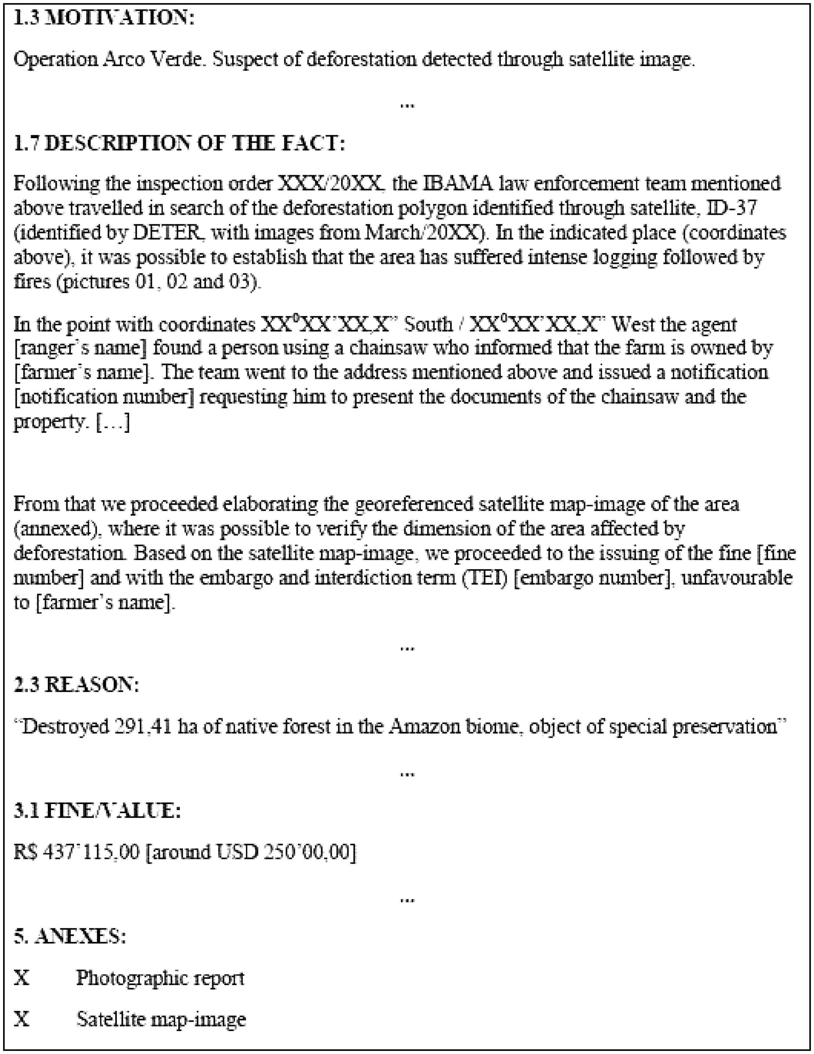
The location of the deforestation is represented in the usual, old-fashioned style drawing on local references only known to those living in the region (1.5). Such locally-bound spatial references, however, are not enough for the attorneys in Brasília, some thousands of kilometres away, to be certain that this fine can only refer to a specific farm, one that the rangers will be able to visit again if required. For this reason, the geographic coordinates (1.6) are inscribed just after the address, in order to locate the property and its owner in a Cartesian plane easily identifiable to someone who has never been near the Amazon.
The description of the fact (1.7) is the central point of the document. In a few crucial paragraphs Aurélio writes that ‘it was possible to establish that the area has suffered intense logging followed by fires’. However, instead of making this claim solely based on his status as a witness, just after this statement he provides the ‘objective’ (Daston and Galison, 2010) evidence for this by pointing to the pictures (widely accepted as objective mirrors of reality) taken in the area. Here he also notes that a person was found in the area ‘using a chainsaw’ who informed the rangers of the name of the landowner – the person responsible for the act.
Finally, the fine, indicative of the area of deforestation (2.3), the value of the fine (3.1) given to the second decimal place, is issued on an old-fashioned handwritten bureaucratic form. The calculations of the total area of deforestation (2.3), and of its value (3.1), are based on the satellite images and not on the rangers’ fallible eyes – Bateson’s (1972) ‘man with a retina’ – and tainted testimony. In this way, the farmer’s lawyers cannot argue that the area of the deforestation has been miscalculated.
It is worth noting what is being deleted (Law, 2009) in the course of enacting deforestation in this particular way. Recall how the informal conversation at the farm (reported earlier) revolved entirely around ‘opening the farm’, ‘making pasture’ and ‘raising cattle’. What we were witnessing therefore was the discursive enactment of ‘clearance’ qua ‘farming’ – ‘deforestation’ was never mentioned. Indeed, rangers in the course of their work become, as we have seen, adept in moving between these different ways of enacting their object of investigation. In the course of coordinating the different inscriptions so that a singular object (‘deforestation’, not ‘farming’) can emerge into the official record, however, this earlier enactment is typically placed under erasure. Erased along with it is any reference to the various methods utilized to transform seemingly routine small talk on mundane matters into ‘objective evidence’ of a crime.
Reality Work
When the rangers have completed their work, ‘deforestation’ has been successfully ‘singularized’ (Mol, 2002) into an ‘objective fact’. Faced with this fact, landowners may turn to a different strategy, seeking instead to exploit the glacial pace of the Brazilian legal system which, until the appeal process is exhausted, can take up to 15 years to judge a deforestation case – with a good chance that the case might expire halfway. In a few cases landowners may choose to pay up and repair the damage. In recent years, however, landowners and better-off farmers have started fighting back utilizing the same methods and devices used by the forest rangers themselves. In 1999 the Mato Grosso Secretaria Estadual de Meio Ambiente (SEMA-MT) created SLAPR (Sistema de Licenciamento Ambiental de Propriedades Rurais), a system for the environmental licensing of rural properties. In contrast to IBAMA’s approach where the state defines ‘illegal deforestation’ and detects it utilizing its own means and agents, SLAPR uses a bottom-up process. Landowners are invited to contract experts who will perform the assessment of their properties and submit applications for environmental licences to the local government. Under this system, it is the responsibility of owners to establish (in a suitably scientific manner) what is forest and what is not, and to determine the level of compliance of their properties in relation to the current environmental law. Since most farms are found in illegal situations, licence applications are usually followed by a contractual commitment on the part of the farmer that, in due course, the deforested areas will be recovered.
Thus the process of data collection and classification – i.e. the process of (dis)establishing ‘illegal deforestation’ – passes into the hands of the landowners and their scientific advisers and devices. Clearly, this changes outcomes in a number of ways. Often the GIS experts hired by landowners are asked to ‘lie with satellite images’, as one such expert cynically summed up the job in an interview. He went on to explain how the relatively low spatial resolution of satellite images leaves considerable room for interpretation concerning where any given deforestation starts or ends, and what is, or is not, ‘deforested’. This enables GIS experts to come up with favourable interpretations of satellite images where areas of doubt can plausibly be re-classified as ‘forest’. Experts are also able to, as it were, ‘perform deforestation’ in ways that can show a specific farm as located not in the rainforest, but rather at the wooded savannah (cerrado) biome, where different legal restrictions apply, thus increasing the legal area for farming from 20 to 65 per cent. The state of Mato Grosso is located in a transition area between these two biomes (ironically, the object of study of Latour’s [1999] scientists in ‘Circulating Reference’). In order to determine where the rainforest begins IBAMA rangers use a map provided by Brazil’s Statistics and Demographics Agency (IBGE). While creating the licence applications to SEMA, however, farmers can, in addition to the IBGE map, also use a map created as part of a 1970s project (RADAM) if it provides a more favourable classification of their land. Even in cases where the property lies within the rainforest in both of these maps, landowners can still hire an agronomist or forest engineer to visit and analyse the physiognomy of their properties in a more amenable manner. The system, then, presents landowners with what we might call alternative substitution possibilities. These, in turn, allow the assemblage of referential chains which pre-emptively perform their own versions of deforestation. In other words, this process of environmental licensing often facilitates a kind of pre-emptive ‘ontological strategy’ against performances of ‘deforestation’ which might go against landowner interests.
We can speak of such ‘ontological strategies’ as (potentially) productive of what we might call ‘collateral’ (Law, 2009) ‘reality effects’ 3 not only at the local but also at the global level. We can see examples of how the former might facilitate the latter in the still ongoing contests over the ways in which the overall rates of Amazonian deforestation are to be represented. In 2008 following concerns that, as one of the INPE scientists put it in an interview, ‘deforestation [had in 2007] started to pick up speed’, INPE commenced publication of DETER’s monthly aggregate data. This data was immediately adopted by mass media and NGOs alike as a measure by means of which developments in the Amazon and the effectiveness or otherwise of government policies could be evaluated. Thus when figures showing a rise in monthly deforestation were released, the federal government created a ‘blacklist’ imposing restrictions on the provision of loans to farmers in municipalities that showed high rates of deforestation. This new regulation was widely praised by environmentalists as the first action of the government that punished deforesters directly by increasing production costs and blocking access to the capital necessary to increase crop areas. Following the publication of the new policy, Blário Maggi, then governor of the state of Mato Grosso, gave an interview to the influential newspaper Estado de São Paulo claiming that the scientists in the Mato Grosso environmental agency (SEMA-MT) ‘knew that these numbers are untrue’. Maggi went further, accusing INPE of ‘lying under the orders of someone’ (Sant’Anna, 2008). Soon afterwards, the Minister of Agriculture also cast doubts on the DETER data and, to resolve the issue, President Lula da Silva asked the federal police and the Ministries of Environment and Agriculture to create a joint commission to investigate the accusation.
To counter the DETER data, Governor Maggi set in motion, as it were, an alternative ‘circulation of reference’ between satellites and forest clearings. This took the form of a major operation to re-inspect the individual clearings identified by DETER. Officials from the SEMA-MT described this operation in interviews as the biggest Mato Grosso (a region where the view of ‘clearing as development’ remains strong) had ever undertaken on the subject of deforestation. In contrast to the usual law enforcement operations carried out by SEMA-MT agents, this particular operation was lavishly funded, involving generous use of helicopters and daily allowances for travel. The outcome of this effort was a report (Lopes, 2008) stating that it was possible to find ‘clear-cut areas’ in only 10 per cent of the deforestation identified by DETER. The Mato Grosso report was immediately followed by a 731-page-long counter-report from INPE conceding that DETER had been wrong in only 3.4 per cent of the cases (INPE, 2008: 26).
Whilst the DETER reporting and the new rural credit policy survived largely intact, many of our INPE interlocutors reported the agency and the environmental faction of the government came out of this clash ‘hurt’ and ‘tired’. Thus one senior scientist at INPE, a key actor in the events described, claimed that Marina Silva’s (Minister of the Environment and one of the most important political figures in the country) decision to resign was linked to this struggle: If Marina did not resign from the ministry maybe all the effort that we have invested in the fight against deforestation could have been compromised. […] Marina sacrificed herself to avoid a Government policy retreat against deforestation in the Amazon, in order to embarrass the Government so that it could not go back on its policies.
In sum, one way in which we can understand the ‘ontological strategies’ of farmers, landowners and their scientific and political allies, is in terms of interference with rangers’ reality work (that is to say their ability to efficiently handle difference), so that deforestation does not emerge as a singular (and thus legally valid) object. At the same time, new ‘patterns’ of reality often emerge out of this ‘noise’. So, for instance, there can be quite dramatic differences in overall deforestation statistics reflecting different ways of performing ‘deforestation’. It would be a mistake to dismiss such performances as ‘merely’ contests over questions of representation – questions that can, as Mannheim had once hoped, be kept in check by a landscape that ‘does not [itself] dissolve into its various representations’ (1936: 97). There are signs, for example, that deforestation patterns are changing in the wake of the new satellite-based detection methods. Thus whilst in 2002 35 per cent of the total deforested area consisted of plots smaller than 0.5 km2 (which are more likely to give rise to ambiguous satellite images), by 2010 this had increased to 80 per cent (Faleiros, 2011) – a parodic enactment of Latour’s (1999: 43) forest that ‘must be prepared to be rendered as a diagram’.
Concluding Remarks
Satellite images and their associated inscriptive devices (ideal-typical real-izations of Heidegger’s [1977] Weltbild) increasingly undergird the methods through which ‘fuzzy’ and ambiguous social phenomena (such as ‘deforestation’) are made available as objects of knowledge and intervention. We have in this paper sought to show the ways in which such devices come to discharge specific referential functions in practice by focusing on ‘the deeds performed when those items are embedded in action’ (Lynch, 1994: 146). In so doing, we have traced Latour’s (1999) ‘Circulating Reference’ in its (rather more) eventful ‘travel[s] in both directions’; that is to say from earth to heaven and from the rainforest to the laboratories and digital inscriptions of the INPE scientists, and back again into the forest in the rangers’ quest to establish correspondence by validating such representations against an originary ‘presence’. In the course of these travels, trials and tribulations, ‘methods’ and their devices appear complicit to the enactment of the realities they seek to capture. As Law, Ruppert and Savage (2011) put it, methods and social realities are ‘always in formation’, always constituting (and unsettling) one another.
The objective, then, is to understand what social ‘realities’ are performed in these practices, by whom and how (Mol, 2002; Law, 2007). An important caveat, however, is that such practices are often implicated in quite different ontological politics than those of Mol’s (2002) arteriosclerosis specialists who typically labour under what we might call the presumption of convergence. Thus whilst Mol’s practitioners share a common objective (helping or curing the patient), the actors in our study are enmired in relationships that are irredeemably antagonistic and conflictual. We can therefore speak of different ‘ontological strategies’ being pursued by the opposing parties. As we have seen, actors often attempt different transformations, transformations that seek to increase as well as decrease ‘ontological multiplicity’ depending on such actors’ positionings and the exigencies of the social situations in which they find themselves.
On the one hand, as we have seen, rangers attempt to make ‘deforestation’ into a singular, and thus legally valid, object. Forest clearings are inspected in order to establish correspondence with satellite images; pictures are taken and physical evidence is collected – objective (in Daston and Galison’s [2010] sense) proof rather than merely the rangers’ own ‘subjective’ testimony. To establish the existence of ‘deforestation’, GPS coordinates (rather than vague local references) are supplied to establish the location of deforestation. Testimonies are solicited in order to establish the intentionality behind, and the ownership of, deforestation. The satellite detected and inscribed deforestation dynamic is used to fix ‘deforestation’ in time as well as in space; and so on. Finally, the representations that are the outcome of the rangers’ particular methods of inscription and visualization must be choreographed in such a way that a singular coordinated ‘deforestation’ emerges whilst alternative enactments of the object are ‘deleted’. When successful, a ‘deforestation’ emerges, robust enough to withstand any future Latourian (1987) ‘trials of strength’.
On the other hand, landowners, farmers, ranchers and their experts, attorneys and political allies attempt to retain ‘deforestation’ as multiple and irreconcilable by calling into question the existence of, for instance, the deforestation (no ‘deforestation’, merely ‘farming’); the causality of the ‘deforestation’ (‘accidental’, ‘unintentional’); the ownership of the ‘deforestation’ (‘in someone else’s land’, ‘in no-man’s-land’); the validity of the evidence for the ‘deforestation’ (‘subjective assessment’, ‘rangers are unreliable and corrupt’, ‘INPE is hostage to foreign interests who under the cloak of environmental concerns are attempting to damage Brazilian agribusiness’); and so forth. At the same time, as we have tried to show, the counter-strategies 4 of landowners and their allies are not themselves devoid of ‘collateral’ (Law, 2009) reality effects.
In seeking to extend Mol’s account in this direction, then, we propose that what is needed is a better understanding of the ways in which performances of particular ‘realities’ often overlay, or otherwise become entangled in, the particular fissures, divisions, conflicts and antagonisms of social life (e.g. Bloor, 2000; Lynch and McNally, 2003). Viewed in this manner, Latour’s (1999) ‘transformations’ that facilitate the circulation of reference must, we have intimated, be also understood as a sequence of potentially highly significant social dramas.
Footnotes
Acknowledgements
We would like to thank Evelyn Ruppert, John Law, Mike Savage and the anonymous reviewers for their generous and insightful comments on an earlier draft of this article. Thanks are also due to Frank Blackler and Niall Hayes for their help and advice.
Notes
Author Biographies
References
Supplementary Material
Please find the following supplemental material available below.
For Open Access articles published under a Creative Commons License, all supplemental material carries the same license as the article it is associated with.
For non-Open Access articles published, all supplemental material carries a non-exclusive license, and permission requests for re-use of supplemental material or any part of supplemental material shall be sent directly to the copyright owner as specified in the copyright notice associated with the article.
