



Abstract
This article looks at the socio-environmental consequences of highway development on host communities in one of Nairobi’s peri-urban corridors. It is inspired by the fact that whereas governmental decision makers have supported highway development by arguing that such construction promotes economic growth and development, decreases traffic congestion, increases travel safety, assists in the more efficient use of existing roads, reduces poverty and improves the environment, this argument is usually pitched at the national or sub-national level thereby ignoring local community interests. Therefore, the study focused on the local socio-economic transformations that are taking place along the corridor as a result of the highway development. Such fundamental transformations occasioned by the road are often not captured in the pre-project impact evaluation documents. In this context, the study found that the construction of the road positively increased accessibility; however, improved accessibility led to land value increases and gentrification. Other effects of road development are land use change and loss of livelihoods, production of inequalities and densification. The study recommends incorporation of ex-post monitoring programs in project development to help mitigate the negative impacts on vulnerable members of the host communities who may suffer in the pursuit of the national development.
Keywords
Introduction
In the developing world, the development of infrastructure is seen as catalyst to and indicator of national development. In what Moran (2016) termed ‘infrastructure-driven transformations’, roads and dams are top in the to-do list of the developmental state in the Amazonia and everywhere else including Africa and Asia. Alamgir et al. (2017) estimated that 90% of new infrastructure will be built in developing nations with roads as a significant portion of it. They estimate that approximately 25 million kilometers will be built in a period of 30 years closing-up in 2050. This grand project is getting significant support from the Chinese-led infrastructure globalization known as the Belt and Road Initiative (BRI) (Hughes et al. 2020; Tian et al. 2019; Wang et al. 2020; Wu et al. 2021).
BRI is a proposal to build a road from China to Europe (the Silk Road Economic Belt) and from Europe back to China along Africa’s coastline, (the 21st century Maritime Silk Road) but there are many non-grand road infrastructure projects across Africa and Asia (Ascensão et al. 2018; Garlick 2020; Tan Mullins 2020). Whereas such road building projects are often certified on the logic of their contribution to national development, their socio-environmental impacts at the local scale are often ignored. However, according to Ali et al. (2018) it is necessary to consider all social, economic cultural and environmental impacts. Similarly, Cramphorn and Davies (2004) have reiterated the incorporation of social impact assessment in the planning of road projects. This article addresses the socio-environmental impacts of highway development at the local scale of host communities in peri-urban Nairobi. Peri-urban development is noted as an area characterized by the transformation of landscapes formed previously by rural lifestyle into urban forms leading to changes in the way people use their environment, the spatial structure of the landscape, and population dynamics (Budiyantini and Pratiwi 2016).
Highway investment is widely regarded by both policymakers and analysts as an effective tool for promoting local and regional economic development (Forkenbrock et al. 1990). Most governmental decision makers have supported highway development by arguing that such construction promotes economic growth and development, decreases traffic congestion, increases travel safety, assists in the more efficient use of existing roads, reduces poverty and improves the environment (Reungsri 2010; Moore and Thorsnes, 1994). Eberts (1990) concurs and observes that local policymakers and researchers concerned with regional issues have claimed for years that public infrastructure investment is one of the primary means to implement a strategy of regional growth. In line with Vision 2030, Kenya’s development blueprint to becoming a middle income nation (Republic of Kenya 2007), the Government of Kenya has since 2008 undertaken major infrastructural developments. In Nairobi these include the Northern, Southern and Eastern Bypasses. This makes the city and its environs major beneficiaries of the bypasses in terms of decongesting the center and opening up the surrounding areas for real estate development to house its working population. The assumption was that the highway (bypass) development would lead to regional economic growth and improve the livelihoods of the communities near the bypass and in the whole region. But is this really the case on the ground?
From the global North’s experience, highways are said to be potential catalysts of economic development (Siccardi 1986; Gillis 1989). They have served an important function in transforming human society and affecting population change (Baum-Snow, 2007; Vandenbroucke 2008). Transportation developments that have taken place since the beginning of the industrial revolution have been linked to growing economic opportunities (Banister and Brachman 2000).
Rephann and Isserman (1994) note that the continuing appeal of highways as regional economic development tools creates the impression that there is agreement on their likely regional economic effects. However, there is contention of this fact from various groups. The first group consists of governments’ officials, citizens of declining rural communities and those who produce highway related goods. This group is of the opinion that new highway is instrumental in creation of broad economic development and growth along the highway routes. The second group which includes growth center proponents are of the argument that highways are necessary but not sufficient for economic development and growth (Huddlestone and Pangotra 1990; Sears et al. 1990; Boarnet 1997). The first group argues that new highway construction may help reinforce urban areas along a route and may eventually spread growth to peripheral lagging regions. The second group consisting of critics is of the view that highway construction development has little merit as such investments are economically inefficient, empirically unsubstantiated and theoretically unjustified.
Through the years, highway construction has caused fervent protests from environmentalists and local communities. Objectors have disputed highway projects on the grounds of negative effects resulting from highway construction such as inequalities in highways access (Deka, 2004), spatial mismatch, (Boustan and Margo, 2009, Ong and Miller, 2005), less frequent family interactions (Loeber et al. 2000) transportation related stress (Song et al., 2006) noise and air pollution, compulsory acquisition of lands and impacts on local biodiversity (United Nations, 2008).
Shindhe, (2006) carried out a study to identify the effects of a National highway bypass on livelihoods of the people around Hubli-Dharwad in India. His analysis found that land prices and amount of land sold increased, cases of accidents while crossing the road to go to school located on the other side, the time spent to reach to the fields to work increased as the fields were separated from the village by the bypass which does not have a service road, shortage of grazing lands as the bypass has taken away some of the land and traversing the bypass is not feasible because of fencing on either side of the road. Observed, also, are increased immigration, outmigration and social segregation as some inhabitants were unable to adapt to the changes. The study concludes that the bypass affects rural livelihoods. The impact is felt more by those who depend on land and natural resources associated with land. It is the poor with small land sizes affected most as they are forced to change their traditional livelihoods and compete with skilled urban people yet they do not have appropriate skills. In contrast people who have larger land holdings or other assets have the opportunity to diversify their livelihoods. Thuo (2013) in his study on impacts of urbanization in the peri-urban fringe of Nairobi notes that although urbanization in these areas provides opportunities for employment, better housing, education, knowledge and technology transfer and ready markets for the agricultural products, increase in population places enormous stress on natural resources and existing social services and infrastructure.
Kenya’s vision for economic growth is spelled out in Vision 2030 country blueprint for economic development. Its aspiration is to have a country that is well interconnected by a network of railways, airports, roads, ports, telecommunications, water and sanitation facilities. Development of new towns like Konza Techno City and investment in infrastructure will be given the highest priority (Republic of Kenya, 2007). This vision is being driven through the implementation of infrastructure facilities which include construction of highways/Bypasses around the city. For Nairobi City, these include the Northern, Southern and Eastern Bypasses. The Bypasses are expected to ease congestion in Nairobi, increase accessibility, promote regional economic growth and improve the livelihoods of the communities near the Bypass and in the whole region. In reality the implementation of the regional economic growth strategy, that is, construction of highways (bypasses) has been done outside the land use context of the adjacent space and in absence of an integrated regional plan. This has led to regional externalities that bring implications on the livelihoods of the communities in these corridors. The intention of this paper is not to provide solutions to the problems arising out of the bypass development but rather to provide information that creates an understanding of issues that arise as a result of the bypass development that can inform the process of policy development.
Conceptualizing social inclusion in peri-urban road development
Marshall and Dolley (2019) have argued for closer research attention to the peri-urban zone which they see as a sustainability frontier where social exclusion is reproduced in the context of changing land use and livelihood transitions drive rapid changes in the socio-technical and socio-ecological systems. One of the human activities under threat in the transformation of the peri-urban zone is agriculture that is required to yield space to urban land use. However, Feola et al. (2020) have argued against this prevalent development culture in the context of Sogamoso city in Colombia, by reiterating that peri-urban agriculture is necessary for urban sustainable development. Ayambire et al. (2019) too, have made the same arguments for Ghanaian cities.
One of the infrastructure developments that cause transformative disruption in peri-urban areas is highway development or road construction. Roads in themselves not only alter the natural terrain, but also building of roads require a lot of material to be extracted from the natural environment. Hence, highway development engenders far reaching environmental impacts. Unfortunately, the understanding of sustainability issues in road construction is limited to material science or the engineers’ perspective of sustainability (Bryce et al. 2017; Giunta 2020). Bryce et al. (2017) enumerated the focus of sustainability considerations in highway engineering including material recycling and reduction of energy demand embedded in the production of materials. Moreover, engineers use life cycle assessment (LCAs) frameworks to quantify the impacts of resource consumption associated with building of roads where socio-environmental impacts are ignored (Alam et al. 2017; Bryce et al. 2017). Material science considerations, however, constitute only one aspect of sustainability.
Apart from material resource sustainability, one of the critical sustainability question concern socio-environmental sustainability, which is the primary concern of this study. Socio-environmental is used in this context to cover socio-economic impacts that are mediated by the physical environment which includes the road, the built and the natural environments. Wolff and Caldas (2018) have advocated for the relation of the social and environmental concepts under what they termed as a ‘sustainability tripod’ that integrates social, environmental, and economic issues. Although socio-environmental impacts can be anticipated ex ante, their manifestation would only follow when the road construction is complete. One of the difficulties identified by proponents of LCA is that it is difficult to include the social pillar of sustainable development in the assessment because social indicators are subjective (Alam et al. 2017). However, ex-post impact studies are necessary for road development projects (Asomani-Boateng et al. 2015). Welde and Tveter (2022) have done such a study but purely on economic benefits related to road development at the local scale. However, the current study is interested in the socio-environmental impacts at the local scale.
The limited understanding of road impacts by engineers is manifested in a book that frames road engineering and development, Road engineering for development (Robinson and Thagesen 2018). In Chapter 5 of this book, “Roads and the environment,” (Kennedy 2018) the environmental scope is limited to the natural and the impacts are limited to the pre-development and development phases and not extended to the post-development period. In this article, we are introducing an ex-post assessment of socio-environmental outcomes of highway development. The ex-post socio-environmental implications of highway development would include impacts of vehicular traffic on local communities (Anciaes et al. 2022; Bharadwaj et al. 2017; Condurat et al. 2017) during the operation of the road. However, the impacts extend beyond this to include damage that was done to the socio-economic system during road construction but whose effects exist after project completion.
Mendoza et al. (2007) studied the socio-environmental impacts of highway development in urban areas of the Amazon found five strands of problems: 1. Infrastructure; including lack of basic services like water, lack of electricity, lack of healthcare infrastructure. 2. Social; including land conflicts, lack of social organization and increased violence. 3. Environment; including weak regulation and river pollution. 4. Economic; including rising land values and lack of employment. 5. Political; including corruption, policy environment and participation.
In this study, we look at how any of these five problems are manifested in the case study corridor for a situated or localized understanding of the permanent or perennial impacts of road development on host communities. In the context of inclusive development, K’Akumu and Gateri (2022) have argued for mandatory ex-post socio-environmental assessments of road development projects. This is in line with K’Akumu (2007, 2010) that underscores the social pillar of sustainable development and conforms to the paradigm of the Amsterdam School of Governance on inclusive development (Rammelt and Gupta 2021).
Case description and methods of study
The study was carried out in Kiambu County along the Northern Bypass Corridor running some 20.5 km from Thika Superhighway to Limuru Road Figure 1. Map of the study area.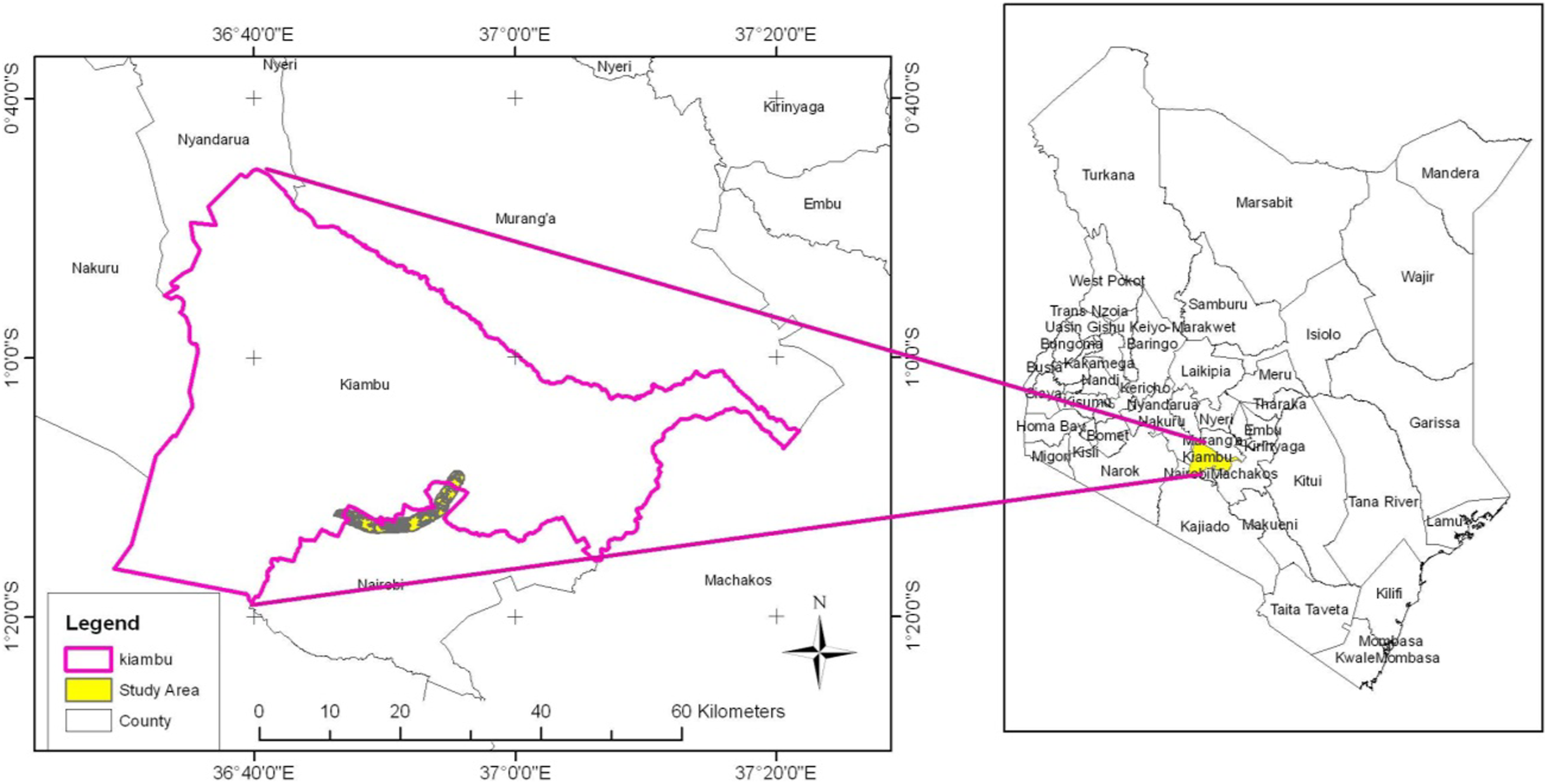
The study concentrated on 1 km on both sides of the corridor to collect data on livelihoods change. The 1 km stretch decision was informed by the fact that after the 1 km, there is another main road which would also have an influence. It would be difficult to separate the effects of the two roads in the area and attribute to one road. The corridor accommodates various classes of settlements including high, middle and low income families. In an ex-post study, a total of 380 respondents were sampled from the area along the corridor to determine livelihood change. The parcels along the bypass were stratified in stratums of 8 depending on type of activities, settlement patterns and income levels. The stratified sampling method was employed here to reflect household economy. This is based on the fact that people settle in a certain area based on their income levels and the activities of specific strata are homogenous and they tend to be affected the same way.
The clusters are shown Figure 2. A total of 50 households were sampled from Kiamumbi and Kamuthi each totaling a 100, 30 each from Marurui and Thome total 60, 30 each from Kamae and Kiwanja totaling 60, 30 each from Githogoro and Kongo informal settlement total 60 and 100 respondents from Kahawa West because it is very densely populated. Sampled areas.
Once the clusters were selected, systematic random selection method was employed in picking the respondents. This involved transacting the clusters along the main streets starting from one end of the street and sampling every 5th household. Where the 5th plot/household was vacant or owner not in, the immediate next was sampled. Counting of the next sample started from the selected household. Professionals were interviewed to give an overall picture of the land values, land use change and livelihoods.
The data was collected through specified transect walks and digital photography, participant observations, focus group discussions with the community members, household questionnaire for household heads along the corridor, key informants and life histories. Primary data was obtained by undertaking a field study of the area and recording what is of interest and significant to the study. An observation sheet was prepared for each questionnaire. This informed the forms of livelihoods changes that can be directly observed. Specified transect walks were done across the study area to directly observe evidence of land use change. Digital photography complemented transects walks as the researcher took digital photographs of some of the observations that were relevant to the study.
Two focus group discussions were organized, one comprising of men only and the other women only. The discussions were held with the different genders because they are affected differently. Women groups (chamas) were identified and used as a forum for discussions. For men, the researcher organized for the meetings since they do not have men groups. For proper facilitation of the discussion, each focus group comprised of 10 members. An open ended question guide was used to generate information within the groups.
Structured and semi-structured interview schedules were administered to 380 respondents between January and March 2015. They were administered by research assistants in English, Kiswahili or the local language where the farmers could not understand the English language. The schedules generated both qualitative and quantitative data collected through face to face method using both open and closed ended questions.
A total of 5 key informants were interviewed in the study. They were purposively selected with an intention to elicit an incisive and enlightening opinion of implications of the bypass on land use, land values and livelihoods. They included; the County Planning Officer, County Valuation Officer, County Agricultural Officer, County Land Officer and an Estate Agent. Five large land owners were also interviewed.
The study used information from life histories. Information dating back to 1970 before the various farms were converted, and the construction of the bypass was examined to give an opinion on the changes that had taken place over a period of time.
Both quantitative and qualitative data from the survey data were sorted, coded and then summarized. Quantitative data was analyzed using descriptive statistics which focused on frequency distribution, totals and percentages. Qualitative data was analyzed using content analysis where the data was grouped into economic, social and environmental issues. For purposes of this paper, only economic issues will be discussed.
Assessment of inclusive development outcomes for host communities
This section of the paper is discussed along broad categories meant to assist in the discussion on the effects and not to discuss issues addressed as mutually exclusive of each other. The paper recognizes that the effects are interrelated and are both direct and indirectly connected to the highway.
High land values and accessibility
The major implication of the construction of the bypass is increased accessibility with resultant advantages including high land values and land use change. One can argue that if the highway did not create accessibility, then the land use and the land values would not have changed. Increased accessibility has led to cheap transport, short time from one destination to another, faster movement and interconnectivity. Before the construction of the bypass, residents used to spend 5 h to go to certain destinations which has drastically reduced to a 30 min’ drive. The fare to certain destinations has also reduced from Kshs 200 (2 US Dollars) to Kshs 50 (0.5 US Dollars). One farmer said, “Some people have really benefitted. They were in the middle of nowhere and all of a sudden they are in the middle of developments.” Increased accessibility has created employment opportunities and increased incomes. The bypass has improved linkages with other land uses and networked the area to other places enabling the population residing here to easily move to work in neighboring towns of Nairobi, Thika and Kiambu. The accessibility has opened up a market for land and residential demand. Before the bypass, there was no market for rentals for residential and business activities.
Increased accessibility has led to increased demand for land in this area and since the land supply is fixed, the land values have shot up. In some clusters, the land values have shot up to as high as 1000%. The main driving force of the land values in the study area is land use change. Land prices do not only reflect the uses of land but also the potential uses of such land. In a competitive market, the price of land will be equal to the discounted sum of expected net returns obtained by allocating the land to its most profitable use. That use may change over time if, for example, agricultural production is currently the most profitable use. But development for some other purpose is expected to yield even greater net returns in the future.
While the Bypass road development influenced the initial property value trends along the corridors, the dynamics that followed have been over taken by the market forces. The result of all these processes is a conversion of land from low value per acre crops such as coffee to high value per unit of land activities such as residential use for renting which has been the main trend. Another result of these changes has been large scale speculation in land, with consequent high costs to the actual settler. This leads to large areas being priced out of any potential market, except that of urban use.
While high land values are good, they have indirectly contributed to negative externalities to the indigenous communities who have not been able to take advantage of the new opportunities offered by the highway and the high land values. These externalities include land use change and livelihood change as discussed below.
Land use change and loss of livelihoods
The high land values have led to land use conversion from agriculture land use to commercial/residential. Data from the household analysis and the land use aerial images indicate that agricultural land is converting to residential/commercial use at a very rapid rate. This has very serious implications both for the community at local and national level due to food security and environmental degradation.
The reasons given for conversion are that farming is very challenging. Before construction of the bypass, there was plenty of land for grazing cows, sheep and goats which would move freely in the ranges. Cattle feed was also available from neighbors at a low cost. But this is no longer available as the land has been taken up by settlements and the remaining vacant sites are farmed intensively by the owners forcing the farmers to enclose their animals. Renting land for farming is also expensive. This necessitates the farmer to buy fodder for his animals as his land is not enough to graze thereby increasing his production costs and reducing profits. This is compounded by lack of labor as the farming community consists of the elderly. All the young men who used to be farm laborers have moved to the booming construction industry where the pay is higher. Thuo, (2013) notes that an increase in rural non-farm job opportunities in peri-urban areas creates opportunities for “decent income.” The changing character of the area to an urban set up is providing many employment opportunities unlike the agriculture setup whose jobs are considered more inferior and thus less competitive.
Asked how they sustain themselves since they were relying on agricultural activities, the respondents gave various responses. One of the interviewed farmer sold part of his land, bought land in a different part of the country which is semi-arid and relocated his family. He was left in Nairobi where he constructed residential units (1 room) with the remaining money on the remaining portion. Others have resulted to selling some portion of land and surviving on that money or sell off entire portions and relocate to other areas where land is cheap. There is also diversification into zero grazing, poultry keeping and pig rearing which require less space and meet demands of an emerging market. But the production costs in zero grazing are very high and the returns are low. Prior to construction of the bypass, residents relied on crop growing, livestock keeping and sales as well as formal employment. Presently, residents have taken to informal businesses and casual laboring as the main livelihoods.
The implication of some decisions is far reaching. For the families selling land like the farmer who relocated his family to Laikipia and was left alone, this decision led to family unit separation as this old man who is 82 years old has been left alone in Nairobi and the family has moved to an area with more land. The others relocating as a whole family are moving to areas where they are foreigners leaving everything behind and going to start afresh. The ones who are selling the land and spending the money on other things are ending up losing everything and becoming destitute. This trend was also observed by Thuo (2013) who concludes that “other people are not culturally, socially and economically prepared in re investing the sale proceeds and thus they end up wasting all the money.” Likewise, Kasanga and Kotey (2001) observe that land tenure in the peri-urban areas in the long run is moving from cropping arrangement to rental thus contributing to insecurity which leads to reduced investment incentives.
Loss of agriculture activity has an implication on food security as articulated by policymakers mainly the planners and agriculture officers who highlight this as the major threat facing not only this area but the country in general with Kiambu being the most affected by upcoming developments and bypasses passing through the area and encroaching into the rich agricultural lands.
The farmers are aware of the consequences of not engaging in agriculture activities and cited food insecurity (69%), hunger (44%), high cost of living (39%), lack of income (35%), overdependence on others (54%), unemployment 52 (24%) and poverty (31%). Food insecurity (69%) and hunger (44%) which are related are already a major concern in the area. As one respondent said “people are hungry.” High cost of living can be attributed to the residents not farming, the supply of food production goes down and the demand goes up, the food prices go up and this affects the cost of everything. The farmers also used to produce animal feed from their own land or buy cheaply from neighbors but this is no longer the case. Lack of income and unemployment are also a very serious consequence more so for those who are losing the rural/agricultural livelihoods and are not able to take advantage of the emerging opportunities in other sectors and they end up in poverty. Poverty is a direct consequence of food insecurity, high cost of living and lack of income which leads to overdependence on others. From this observation, it is clear that the loss of farming for this community is major cause of poverty as all these consequences lead to poverty.
The community is concerned that the foods they used to enjoy are not available or is expensive. Most cited is lack of vegetables, arrowroots and milk. The available vegetables and arrowroots are mostly grown in sewage areas. Food safety was also highly guaranteed as they were grown in a rural environment. They are not sure of the source of their food. As one lady who lives there said, “we could not eat vegetables sourced outside our homes or a neighbor’s home as we considered it highly contaminated. But now we have no choice but to go to the market to get the contaminated one”.
The loss of the agriculture activity which was the main source of livelihood is a major blow to the economy of this corridor as the farmers have not been able to diversify may be due to their age and lack of resources.
Accessibility, loss of income for the indigenous population and increased inequality
The Northern Bypass has created accessibility opening up the area to many opportunities, contributed to income dynamics and displacement of the indigenous population. Increased accessibility has created employment opportunities and increased incomes. The bypass has improved linkages with other land uses and networked the area to other places enabling the population residing here to easily move to work in neighboring towns. The accessibility has opened up a market for land and residential demand. Before the bypass, there was no market for rentals for residential and business activities.
In terms of income interpreted as increased business opportunities or creation of employment opportunities, 108 out of 160 (68%) respondent tenants and 107 out of 220 (48%) farmers’ respondents said the bypass had increased employment/business opportunities. This observation is because it shows that the original land owners are not really seeing the business/employment opportunities the bypass has created as opposed to the tenants who are benefitting and are the newcomers who moved in here because of these new opportunities.
This brings in the aspect of displacement of the local population. The high incomes being enjoyed as a result of the increased developments are not by the locals. A small area near the bypass with a mix of high rise buildings in the middle of original old temporary structures revealed that out of the 10 high rise buildings in the area, none of them belongs to the original owners. They were bought off and relocated to the interior where the land is cheap. An estate agent in the area confirmed that the plots he is selling are being bought by “outsiders” who are coming and demolishing the old houses and constructing high rise flats. Some are having arrangements with the owners who subdivide the ¼ acre and are left with just a small parcel for their houses mainly 40 ft by 20 ft where the house stands. But they eventually sell off even that parcel. One of the opinion leaders interviewed said that “I know we are visitors here” implying that very soon they (locals) will all be gone.
The above scenario has contributed to increased inequality where the newcomers who are buying land in the area have more resources than the local population who are not able to compete. The new opportunities presented by the bypass are being exploited by the newcomers increasing the gap between the rich and the poor in the area which was not the case before the bypass as all the locals were more or less at the same level of resources.
Accessibility is a blessing in most cases but in some cases, poor accessibility may actually benefit and protect businesses in weaker regions. Better transport connections opens local markets to the increased competition of larger businesses outside the regions that produce a greater variety of products at lower prices. Deike (2000) notes that this reduces the regional monopoly power of existing businesses. Local farmers complained that they are facing stiff competition from farmers in the larger region, for example, Murang’a, Laikipia who are able to supply cheaper milk, eggs and other farm produce to Nairobi due to ease of accessibility. Production costs in the rural areas are lower because of cheap labor and availability of cheap feeds making the production cost low as opposed to peri-urban communities practicing zero grazing at high production costs. When accessibility is improved, the transport cost goes down and the rural farmer or middlemen are able to explore a wider market.
The peri-urban farmer who has a small land size, limited pasture land and high labor costs is disadvantaged. As Deike, (2000) notes, the region as a whole is negatively affected by the local non-competitive businesses that struggle and begin to fail. In this case, the farming occupation begins to struggle and eventually fails.
Opening up the region to intra-regional competition requires some local sectors to be strong enough to survive the competition. There should be a plan to either change the land use or protect the existing regional economics. The land use studies recommended that this area be preserved as agricultural due to its significance to the national economy and the regions’ employment creation. (Nairobi Urban Study Group, 1973).
The household survey analysis reported that 49% of the farmer’s population have recorded reduced incomes as a result of the bypass. These are the farmers who were mainly dependent on agriculture activity for their livelihood but do not practice it anymore due to reduced land sizes. Others are experiencing business disadvantage especially those depending on the local market because it is easier to supply the goods in this area from afar where the production costs are lower and therefore sell cheaper because the transport costs are very minimal.
Increased population, increased demand and high cost of living
When asked how the Bypass has affected the area 72 out of the 220 (32%) farmers interviewed said it has increased the population in the area and 99 out of the 160 (62%) tenants interviewed said it has caused population influx. This population influx may not necessarily cause displacement as the indigenous owners had various portions of land but the population has provided a very large market for land as they come in and settle in the portions that were initially meant for farming.
There is an influx of population into the area as a result of very many factors namely accessibility thereby opening up the area and attracting people who would otherwise have not heard of the area or the area was not attractive but is now attractive, business opportunities in the rapidly developing area and booming construction industry for residential uses thus attracting labor. The highest population movement is into the upcoming urban centers and expanding informal settlements along the bypass. The other factor attracting the increased incoming population is the sale of the land that the farmers were using for farming and the subdivision of the former one acre share to 1/8 acre portions. The people migrating to this place are mostly in lower middle income and are of middle ages (30–55 years old).
The increasing population has come with many challenges for the indigenous population. The main challenge is increased demand for everything in the area leading to increased prices. The cost of living has gone up in the area. This can be attributed to various factors. First is the change in land use from agriculture to residential/commercial use. This means reduced food production, reduced food supply, increased demand and increased food prices. Second is the transformation from a rural setup to an urban set up where everything is bought as opposed to the period before the bypass when there were many farmers and food supply especially milk and vegetables was high. The high land values have contributed to the increased rents. Rents consume a substantial amount of every household’s income and this has translated to a high cost of living. The tenants have registered a higher response (91) in this aspect as opposed to the farmers (88) because they pay rent and depend on buying for everything as opposed to the farmers who live in their homes, have kitchen gardens and some have a cow providing milk so everything is not for sale cushioning them against the high cost of living. The high rents can also be attributed to the increased population creating a high demand for housing.
An emerging issue of debts was not openly discussed in the household questionnaire but it was implied. When the farmers who have constructed rental houses were asked the source of money for construction, they indicated sale of land and borrowing from banks or cooperative societies. This has introduced the issue of debts which they never had before because they were comfortable with farming and no need to borrow. This is not necessarily a bad thing but in cases where the interest rates are high or the money is mismanaged and they do not complete the construction, or the construction is completed but the return is not high enough to service the loan, then the farmers will end up losing everything to the bank. They will also be servicing the loans for a long time. Debts are also a reflection of the changing culture in the area as the rural community is generally very cautious with borrowing especially where land is concerned as opposed to the urban community which is not afraid of debts.
Sengupta, et al. (2007) in their study in India concluded that in developing economies such as rural India, a huge public investment project on the development of road infrastructure is not only beneficial to the larger national economy but may as well help in minimizing poverty in rural areas and civilizing the socio-economic welfare of the local population residing in the roads environs. However, in the study area this has not happened. Poverty at the local level has been created by displacements, sale of land and squandering of the proceeds, high land values making land purchase out of reach of the majority, high rents and high living cost. The transformation process of the area from rural to an urban set up is contributing to the poverty for the indigenous population who were used to a rural setup where everything was cheap and available as opposed to the current situation where resources are scarce. The fact that poor (farmers) have fewest of the livelihood assets needed to cope with these changes make them vulnerable.
Construction of the bypass has led to shortage of fuel wood which is a basic necessity for the majority of the farming community. Most of the farmers were dependent on firewood from the coffee plantations and trees in the area or charcoal. But the coffee plantations are not there anymore and they have resulted to buying charcoal, paraffin for stoves or gas. These are very expensive options for some who do not even have a source of income.
This increased population was not planned for as the area has changed use informally with no land use plan which would guide the developments. Increased population brings with it environmental challenges into areas that were initially near natural. Among the key one include waste generation, wastewater discharge, air pollutants and elevated noise pollution. No provisions on social amenities were factored to match the roads and the associated social and economic developments taking place.
There is emergence of accidents. Before the construction of the bypass, there were no accidents as there was no road to cross or cars to collide on the road. The accidents have come with the bypass and they are many and serious. Various factors can explain these accidents. These include the design of the road which passes through populated areas with no consideration to safety issues for the road users, inadequate road signage and safety provisions (footbridges, pedestrian crossings, footpaths and speed control bumps) at high population sections of the road bypass posing significant danger to the safety of road users and increased vehicle movement. When the road was envisaged in 1973, it did not take into consideration this huge population and was constructed to handle light traffic. The bypass divided the area into two with members of the same community living on different sides of the road but the need for daily interaction is still there so they keep on criss-crossing the road at all times. The road users are also to blame as they do not respect the Zebra crossing and cross at any point. There is also encroachment of business activities on the road junctions which have become undesignated urban centers. Hawkers target the motorists because traffic is slow as a result of the rumble strips and bumps erected to slow down traffic in the busy center. The hawkers are sometimes knocked down as they compete and chase motorists to purchase their goods oblivious of the moving vehicles.
Perhaps the original concept of the bypass design did not anticipate an influx of residents and institutions. Now that it has happened, necessary safety provisions should be integrated such as to include service roads, pedestrian crossings zebra crossings and footbridges, footpaths and cycle lands, additional bus bays as well as enhanced signage and safety information.
Conclusion
Development of transport facilities like road infrastructure can play a significant role in changing the socio-economic conditions of the people of a region through dynamic externalities that such development often generates (Sengupta et al., 2007). Roads may affect livelihoods differently either destroying or generating livelihoods at the same time. The impact is felt more by those who depend on land and natural resources associated with land. It is the poor with small land sizes affected most as they are forced to change their traditional livelihoods. They have to compete with skilled urban people and yet they do not have appropriate skills.
In contrast people who have larger land holdings or other assets have the opportunity to diversify their livelihoods (Shindhe, 2006). Some of the transformations taking place in the rural urban fringe are leading to improvement of livelihood for a number of actors. Some members of the host community have taken advantages of new opportunities and have networked with newcomers to access resources not present in their surroundings. Others have taken advantage of economically better-off newcomers to start businesses to cater for their service needs. However, there are some members who are alienated from their livelihood when circumstances force them to sell land. There is loss of agriculture as a viable enterprise in these areas, unplanned residential development resulting in urban sprawl, increase in population, demand for more infrastructure services which are not being provided as they are not planned for and resultant environmental deterioration (Thuo, 2013).
The study area has experienced significant changes in livelihoods but in the process, the local community has suffered. Whereas the highway development major benefit is increased accessibility into the area, thereby reducing transportation costs which is a blessing to all, it also created competition edging out the local indigenous population and destroying agricultural livelihoods. The road has resulted in production of social inequality and increased the gap between the rich and the poor. This is a tragedy for a country like Kenya where the interest in highway construction has peaked with the Kenya Vision 2030 development plan and its implementation with construction of major infrastructure projects which are supposed to propel Kenya to a middle income state by the year 2030. If the trend is left unchecked, the realization of the Kenya Vision 2030 will remain a dream.
The benefits from efficient road transport should be felt at all levels of the society, directly or indirectly, such as to include improved national economy, social income, wealth and job creation, healthcare, public transport and general service delivery. Improvement of all these areas is desirable for the current national aspirations including inter-sectoral growth collaborations. For this to be realized in the study area, the policymakers need to incorporate ex-post monitoring programs in project development to help mitigate the negative impacts on vulnerable members of the host communities who may suffer in the pursuit of the national development.
Footnotes
Declaration of conflicting interests
The author(s) declared no potential conflicts of interest with respect to the research, authorship, and/or publication of this article.
Funding
The author(s) received no financial support for the research, authorship, and/or publication of this article.
