



Abstract
This paper argues that water gradually became, over a period of more than half a century, a critical boundary object between science and governance in California. The paper historicizes ‘water’, and argues that a series of discrete problems that involved water, particularly the reclamation of ‘swampland’ in the Sacramento Valley, gradually came to be viewed as a single ‘water problem’ with many facets. My overarching theoretical aim is to rethink the ontology of the technoscientific state through the tools of actor-network theory. I conclude with the following paradox: the more the technoscientific state forms into a complex gathering – or ‘thing’ – of which humans are part, the more it is represented and perceived as a simplified and singular actor set apart from those same humans.
Keywords
This paper argues that water becomes a principal boundary object through which governance and science become networked in the modern period. ‘Boundary objects’ were originally conceived as both adaptable to different viewpoints, and yet robust enough to maintain their identity across different groups (Star and Griesemer, 1989). Water can be understood as a boundary object in this way, but my primary interest is in how it is constituted as an object at the boundary between science and governance. That is, my focus is on how water serves as a critical point of contact between two otherwise relatively distinct realms of institutional action, a contact that generates new discursive, organizational, and material forms in both realms, which in turn stitches them together. The result is not scientific government, but a technoscientific state formation composed of a complex set of continuously contested and shifting interconnections. The extent to which water plays such a role will vary considerably across cases, but California exemplifies the process.
My focus is on the period circa 1850–1915, when the state government became involved with water issues primarily with respect to the reclamation of land in the Sacramento Valley, mining debris in the Sacramento River system, and inland navigation. Irrigation was also important, but before the 20th century the role of state government was primarily that of facilitating private works. In the context of these problems, water began to form into a punctuated boundary object between science and governance in the state. It also became an increasingly differentiated ‘matter of concern’ (Latour, 2004). However, I begin the analysis with the concept of boundary object in order to start out parsimoniously and from that point reveal the development of complexity. In addition, the term ‘boundary object’, in contrast with ‘matter of concern’, explicitly combines conceptual and material elements.
As discussed in more detail below, my broader research objective is in the area of state theory. In particular, I argue against the conceptualization of the state as an actor with distinct interests engaged in a struggle with other super-human actors. Contrary to the way the state is regularly portrayed in state theory as a coherent singularized actor (see Carroll, 2010) that speaks and does things based upon its postulated interests, desires, beliefs, and so on, in this paper I treat the state as a heterogeneous assemblage of humans and non-humans: of land, dams, levees, aqueducts, maps, meters, organizations, discourses, individuals and so on. By focusing on the networking of science and government around boundary objects, as opposed to the ‘relations’ between ‘science and the state’, I seek to avoid the taken-for-granted view that in the modern period only ‘nation-states’ are genuine states and, therefore, proper objects of state theory. This view, which dominates political–historical sociology, is the result of an overemphasis on jurisdictional ‘sovereignty’ (understood as absolute) and ‘geopolitics’ (understood as international), as key defining criteria of statehood. The issue, however, is more complex, particularly in the US. ‘Provincial’ or federated ‘states’ can also serve as distinct cases for studies of modern state formation. Indeed even cities, particularly mega-cities such as Los Angeles (LA), can be viewed as cases of modern technoscientific state formation, as techno-territorial heterogeneous assemblages. Though the specific case of LA is discussed only briefly in this paper, few would deny that water has served as a critical boundary object between technoscience and governance in the development of that city. My approach complicates the binary opposition between the centralized ‘nation-state’ and the non-state governance of the variously local, civil, social, or economic domains. It agrees with Timothy Mitchell’s (1991) argument that it is impossible to draw a neat boundary between ‘state and society’, a point demonstrated by Karen O’Neill (2006) in her study of flood policy on the Mississippi and Sacramento Rivers, particularly with respect to the dividing line between state territory and private property. Indeed the very distinction between state and society is constructed within specific state formations. The distinction does not exist, in some primordial or a priori sense. The distinctions and divisions between private and public, state and non-state, local and regional, provincial and national, and national and global, are worked out and constructed within specific historical–political contexts and policy regimes, and are therefore subject to ongoing negotiation and change (see for instance the volume edited by Karen Bakker (2007) on the governance of water in Canada).
Literature and theory
Water becomes so central to the history of California that it is not uncommon to hear it said that the history of the state is ‘all about water’. In this context a veritable industry has grown up around California’s ‘water wars’. The stories told are populated by nefarious politicians and greedy developers, backroom deals, and sinister motives. In the context of LA, there is, appropriately, even a movie. Roman Polanski’s Chinatown tells the story of the dirty politics supposedly at the heart of the effort to bring water to the LA region in the early 20th century. Steven Erie has recently deflated this narrative, revealing LA’s Metropolitan Water District (MET), and the City’s Department of Water and Power (originally the ‘Water Department’), as rather mundane agents of a developmental city-state (Erie, 2006; Erie and Mackenzie, 2009). This is not to say that there was not a lot of corruption, but rather that the water context was not exceptional relative to other areas where big government and big money intersected in the US. In the context of transferring water from the northern to the southern part of California, the narrative is often one of theft – the south stealing the north’s water (Gottlieb, 1988). One gets the impression that the waters of California are polluted with bad actors. It is a narrative punctuated with clichés. The first cliché, of course, is that of ‘water wars’. Then there is the notion that ‘water is the lifeblood’ of the state. Mark Twain is a favorite source for quotation: ‘Whiskey is for drinking; water is for fighting over’ (despite there being no evidence whatsoever that he ever said this). ‘Water’ is now the ‘new gold’, or the ‘new oil’. Senator Barry Goldwater, the quintessential man of the western US is regularly quoted: there are ‘three things a western man cares about: water, land, and women. In that order’ (quoted in Espeland, 1998: 4). These stock phrases act like a scaffold for the idea that water is ontologically primordial. It is a given, a point departure for everything else, and nowhere more so than in California and the western US.
I wish to show the particularities of the California case framed from the perspective of a state formation analysis. Indeed I seek to further specify the California case by focusing on where the state government was initially most concerned with water issues, that is, the Sacramento Valley. The ‘all about water’ framing is invariably focused on the conceptualization of California and the west as a desert, so that the central battles revolve around irrigation and urban development. Marc Reisner’s Cadillac Desert: The American West and its Disappearing Water (1986) is the classic popular example. It becomes a truism that land, as a longtime chair of MET put it, ‘is just land until it gets water on it’ (quoted in Gottlieb, 1988: 8). The populist desert narrative, along with its expression of indignation about evil-doers (Boyle et al., 1973), is also expressed in the more sophisticated analyses of environmental historians. Here, too, the case of California is framed in terms of the arid west. This is partly because environmental historians are sensitive to the regional character of natural environments, and how they do not always align with political boundaries. But it is also because the California case fits, in some key respects, with the characteristically regional ‘water politics’ of irrigation and conveyance in the west (see for instance, Cronon, 1992; Espeland, 1998; Gottlieb, 1988; Hundley, 2001; Pisani, 1984; Walton, 1992; Worster, 1985). Regional analysis often focuses on the broad themes of American destiny, western expansion, capitalist land speculation, colonization, empire- building, the increasing role of the federal government in facilitating settlement, and so on. Federal reclamation, in the form of damming rivers and conveying water to arid lands, is rightly seen as part and parcel of these wider forces and ambitions. And there is little question that, from the execution of the Pacific Railway Surveys in the 1860s, the creation of the US Geological Survey (USGS) in 1879, and the US Bureau of Reclamation in 1907, California was central to those ambitions and is an important part of that story. Indeed, Sacramento was chosen as the western terminus of the transcontinental railway. However, unless the specificity of the Californian case is granted, it can be forgotten that a large area of the state was considered ‘swampland’. For instance, Donald Worster, in his Rivers of Empire: Aridity, and the Growth of the American West, mentions the word ‘swamp’ only once in his entire book, and this in the context of a comment about over-irrigation flooding land (Worster, 1985: 153). Contrary to that picture, California state government claimed about 2 million acres (8000 km2) of Sacramento Valley swampland from the federal government. Then, in order to protect that land from flooding after being reclaimed, between 1911 and 1950 a state government flood control project was built at a cost of around $100 million. This was no small thing, but it only receives the attention it deserves in works that are specifically focused on flood policy (Kelley, 1998; O’Neill, 2006).
Seeking to avoid the pitfalls of the ‘all about water’ and its related desert narrative, I resist the idea of framing the analysis from the beginning around ‘water’. In this sense my aims are quite different from those of environmental historians. I want to understand the role water played in the development of a technoscientific state in California. To do so requires historicizing water, showing how, in this particular case, water became an object of government. The result is revealing. In the first 50 years following the state’s founding in 1850, the government did not view water as a problem in and of itself. There was a discourse of ‘water rights’, but no department or division of the state government with the word ‘water’ in its title. However, by the early 20th century water had become an object of government in and of itself. Water became a boundary object between science and government, for instance, through the formation of a ‘State Water Commission’ and a ‘Division of Water Rights’ within the Department of Public Works. This new object of government was circumscribed in specific ways. For instance, the State Water Commission did not concern itself with ‘holy water’ or ‘curative water’. Water was conceived as a technoscientific object in terms of hydrology, geology, hydraulics, chemistry, engineering, and so on. Explaining how this happened requires understanding how, historically, government initially confronted discrete problems that involved water, and how these problems gradually came to be seen as interconnected parts of a single ‘water problem’. This is not to suggest an origin story (though the promoters of reclamation in California never missed an opportunity to articulate one themselves, and also to point to contemporary works throughout the world as justification for the works they proposed). 1 On the contrary, it is to say that in California water became an object of modern technoscientific government through a historical process with a specificity and chronology that can be both identified and documented. The Californian case will, of course, share much with other cases. But understanding what it shares, and how it is to be understood in broader contexts, can only come from an understanding of its specificity.
The first, and by far the most important early water-related problem in California was that of reclaiming the swamp of the Sacramento Valley, and the subsequent efforts at flood control. Indeed the surveyor general reported as early as 1857 that draining swamps was one of three tasks central to the policy of ‘internal improvement’. 2 The second problem was the ‘debris’ that ‘hydraulic mining’ deposited in the rivers. The third, intensifying as agricultural production continued to grow, was the problem of inland navigation. Eventually these would be viewed as interconnected. They also would be connected to problems that emerged later, such as salinity control, hydroelectric power, and irrigation of the deserts. Irrigation, more generally, is a fourth general area in which water became an object of government early on, but until the early 20th century it was of concern mainly in terms of ‘water rights’ (Hess, 1917). Legislation in 1854 permitted individuals to form ‘water townships’ (Malone, 1964: 84), but for the first 40 years of the state’s history the irrigation issue was left largely to the courts as bill after bill failed to pass. Folding the California case into the narrative of the desert west misses the critical point that very little was pursued or achieved until the 20th century by the California state government on the irrigation/conveyance front. This was importantly because of the ‘geographic-sectional contest between a relatively arid, pro-irrigation south and a more humid, anti-irrigation north’ (Malone, 1964: 12).
So while there was a considerable amount of irrigation taking place (and almost as much litigation about it), state government did little but talk until the late 1880s. Not until 1887 was legislation passed that permitted the formation of ‘irrigation districts’. In 1888 the State Engineer complained bitterly that he was not provided the necessary funds to adequately survey the state with a view to an irrigation plan (Hall, 1888: 7ff.). By the beginning of the 20th century most of the irrigation was localized in the LA and Owens Valley regions. As one report put it in 1901, ‘in order to realize what irrigation has accomplished in California one must go the southern part of the State’ (Mead, 1901: 37). Nonetheless the number of irrigation districts grew rapidly, especially as powerful centrifugal pumps powered by steam and then diesel engines developed the capacity to tap into large amounts of San Joaquin Valley ground water, an approach that avoided the water rights chaos associated with river diversions. In the case of California the argument for state involvement in building irrigation/conveyance infrastructure, as distinct from facilitating private and district works through water rights law, gained salience because so much ground water was pumped from the San Joaquin Valley aquifer that by the 1920s it was seriously depleted, and in some places farms were already being abandoned.
In 1908 the government of LA bypassed state government and embarked on building a conveyance system that moved water over 200 miles (320 km) from Owens Valley to the city. This allowed the population of LA to grow rapidly, which created the context for the elaboration of the narrative of scarcity in the south versus abundance in the north, a narrative that was constantly reiterated to justify the huge conveyance projects known as the Central Valley Project (1930s to 1950s) and the State Water Project (1950s to 1970s). The argument that the water in the north needed to be sent south because that was where the people were ignored the fact that so many people were in the south to begin with because of water conveyance infrastructure (see Alatout, 2008 on the construction of ‘scarcity’). Nonetheless, it is in this context that California fits most clearly with the regional desert narrative, and also the ‘water wars’ narrative. Before the 1920s, however, California state government was most engaged with the issues related to reclamation and drainage in the Sacramento Valley.
It was the multiplicity of problems related to water in California that created the context in which the idea of ‘water as a resource’ became salient (Linton, 2006). They were all captured within the singular designation ‘the state water problem’. More recently Linton has gone further and provided a fully historicized account of water. His book title asks What is Water? and he answers starkly that it is ‘what we make of it’ (Linton, 2010: 3). Linton’s thorough historicization of water is hugely welcome, though I do not adopt what I take to be his epistemological and ontological relativism. I have nothing to say about the relative merits of different conceptualizations of water, for instance those articulated by natural scientists or by native peoples. Nor do I take sides in disputes between technoscientists on issues related to water. Rather, I am historicizing water as methodological strategy, what Harry Collins (1992 [1985]) termed ‘methodological relativism’.
It is perhaps not surprising that it took a geographer (and environmental activist) to fully historicize water, as that discipline has for a long time been engaged in problematizing the modernist separation of nature and society. Nor is it a surprise that Linton would appear to grant equal status to indigenous peoples’ conceptions of water as are generally granted to scientific accounts. Perhaps even more so than the environmental historians, the cultural geographers are engaged in a normative political agenda where ‘social justice’ is rendered as ‘environmental justice’, thus reworking traditional political economy into ‘political ecology’ (Bakker, 2003: 54; see also Loftus, 2009). I do not have a normative agenda, but work in geography articulates very effectively what I am arguing about the ontology of the modern state. Geographers have been centrally concerned with how nature and society are related, coining the term ‘socionatures’ (for example, Bakker, 2010; Kaika, 2006; Swyngedouw, 1999). They have also emphasized the ‘coproduction’ of nature and culture (Bakker, 2003; see also Carroll, 2006; Jasanoff, 2004), and their hybridization. In this context, issues in Science and Technology Studies (STS), particularly work by scholars such as Donna Haraway and Bruno Latour, ‘forced their way onto the agenda’ of geographers (White and Wilbert, 2009: ix). This has led political ecologists to elaborate the concept of ‘technonatures’, a term that resonates with my attempt to understand the state as a human/non-human assemblage composed of ideas/discourses, practices/organizations, and natural/cultural materialities. White and Wilbert explain that:
[the term technonatures] seeks to highlight a growing range of voices ruminating over the claim not only that we are inhabiting diverse social natures but also that knowledges of our worlds are … ever more technologically mediated, produced, enacted, and contested … . (White and Wilbert, 2009: 6)
STS demonstrates that modern science has always been technoscience, that is, its knowledges have always been ‘mediated’ by technologies. This leads me to a broader context in which developments in the Sacramento Valley need to be situated–the context of the development of what I call ‘engine science’ (a further specification on the concept of technoscience) in the 17th century (Carroll-Burke, 2001). At least four key engines can be identified with engine science, and they drive the coproduction of science and society, nature and culture, and science and technology. They are chambers (for example, pumps), scopes (microscopes), meters (barometers), and graphs (maps), as well as many hybrid forms such as theodolites (scope and meter combined). Graphs represent the world in inscriptions (including textual). Meters transduce the world into number. Scopes target phenomena and augment it to the senses. And chambers capture phenomena so they can be subjected to controlled manipulation, often with extreme force. In the 17th century William Petty stated that the first order of business in crafting a state was a map, and roughly two centuries later, the California state government, immediately upon its founding, created an office of Surveyor General to scope out the landmass and graph it on maps. Though beyond the range of this paper, pumps increasingly became critical material cultural elements of the technonatural assemblage of California, both for drainage and irrigation. And as I show below, meters became crucial technologies for shifting policy and determining outcomes in the Sacramento Valley. These technologies were employed before a highly articulated idea for the scientific ‘conservation’ of water appeared in the early 20th century (Linton, 2006; McGee, 1909).
While the concepts of socionatures and technonatures articulate with my own aims, this work is less likely to address the question of the ontology of the state, perhaps because of the dominance of the Marxist legacy within socio-cultural geography. This can be seen in the collection on technocultures edited by White and Wilbert (2009), where not a single contributor directly confronts the ontology of the state. Sometimes the state is equated with national government (variously as regulatory protector of, or handmaid to capitalist destruction of, the environment). Bakker and others have recently sought to add nuance to this by decoupling ‘governance’ per se from ‘the state’, defining the former in terms of how decisions are made and who gets to make them (Bakker, 2007). A growing number of geographers are rethinking governance, as well as directly confronting the ontological question of how to conceive of ‘the state’. For instance, Mark Whitehead notes that despite ‘the enduring legacy of states within environmental policy-making, analyses of state–environment relations are consistently inhibited by analytical confusion surrounding what the state is and what the state does’ (Whitehead, 2008: 428). Whitehead draws upon Foucaultian work on governmentalities as well as actor-network theory (ANT) to question the efficacy of the ‘eco-Marxist’ view of the state. He notes that ANT challenges the idea of the state as ‘a kind of super-human structure with the ability to control and manipulate the environment while hiding the messy complexities and incompleteness of contemporary government processes’ (2008: 429). Whitehead seems, however, to be unable to relinquish the notion of a ‘relationship’ between state and environment in which the state is an actor that does things. I am seeking to push actor-network theory further to show that the state is not an entity set apart from the ‘environment’ because it is critically built into and out of the environment. Technonatures are also techno-territories and techno-jurisdictions. Indeed the greater the extent of the networks of technonatures; material cultural infrastructures; and governance, the less it makes sense to conceive of state/environment relationality in a singular macro way. I argue that the ontology of the modern state, and thus by definition technoscientific state, should be conceived of as a complex thing, a particular kind of society, despite the common-sense view that it is a macro actor set apart from society.
Of course the natural materialities of land (such as watersheds, valleys, or arid regions) often traverse state territorial and jurisdictional boundaries, so technonatures often have to be understood regionally (itself a jurisdiction) or cross-nationally. For instance, Rudy (2005) demonstrates how Southern California’s Imperial Valley is, at the same time, a watershed, a region, and a cyborg (or technonature). But natural materialities can also significantly define states. For instance, about two-thirds of California is significantly defined by the ‘Great Central Valley’. Indeed one geographer has described the state as ‘a single, mountain-walled prairie’ (Johnson et al., 1993: 11; this is obviously a bit of an overstatement). How state territories come to map onto landscape is, however, historically contingent. In the case of California, the eastern boundary of the state was drawn along the Sierra Nevada Mountain Range for reasons totally unrelated to ‘nature’. Its location stemmed primarily from the desire for rapid entry into the union. After the Mexican–American war ended in 1848, ‘California’ became a ‘territory’ of the US that extended all the way to Texas, encompassing present day Utah, Arizona, Nevada, and New Mexico. Indeed the eastern and northern reaches of California constituted a frontier without any well-defined borders. By inscribing the new state border along the Sierra, the framers of the state constitution placated the slave-states, the representatives of which were deeply concerned about the size of this new free-state in formation. In doing so, the framers made much of California co-extensive with the great valley, with profound consequences for the history of the state in relation to water. In the context of state formation in California, the water infrastructure constitutes a technonature that is importantly also a ‘techno-territory’ (Carroll, 2006). Ironically, had the specificity of the historical context been different, the State of California could well have become almost one and the same with ‘the west’. In any case, the way jurisdictional boundaries, at whatever level, are or are not contiguous with natural features of the landscape is central to studies of technonatures and state formation.
In California, when water becomes a boundary object between science and governance it serves to rapidly gather both human and non-human actors into the state. That is, it serves the process of assembling a state. ANT is particularly well positioned to provide insight into this process, a process at the heart of technoscientific, techno-territorial, and technonatural state formation. This is because of the role ANT grants to non-humans in three key respects. First, non-humans are granted the ability to act and thus cause social change. Second, it demonstrates how non-humans are ontologically critical to the material constitution of the networks out of which technoscientific states are made. And finally, it permits the treatment of non-humans, like water or land, as relational objects, that is, objects that can change depending upon how they relate to other objects and actors. In addition, by providing conceptual access to how science and governance became networked, how levels of governance were articulated, and how state power was materialized, it permits us to refigure the state’s ontology as a ‘thing’ composed of heterogeneous elements, rather than a single coherent actor distinct from society (Carroll, 2006). Thus, in terms of geographers my conceptualization of the state is closest to that of Joe Painter, who describes the complexity of the state in terms of its ‘prosaic’ character (Painter, 2006). Unlike Painter, however, I do not associate thing-ness with reification. Rather the main way the state is reified in theory is by conceiving of it as some kind of quasi-person, that is, as an actor. The association of thing-ness with reification results from the equivalence that is assumed between things and objects.
Latour has argued that we should reclaim the meaning of ‘thing’ first articulated by Heidegger, but reject the sharp distinction he drew with the word ‘object’. Heidegger noted that the word ‘thing’ originally meant a ‘gathering’ (Latour, 2004: 233). Hence some of the earliest parliamentary assemblies were called Things. Latour adds that things, when the richness of their construction is suppressed, can become objects. I believe we can think of the two words as forming a variation, in the sense of an oscillation, around the word ‘materiality’. The value of resurrecting this meaning of the word ‘thing’ is that it permits us to designate the state as both a matter of fact (object) and a matter of concern (thing), an ‘object out there and, in another sense, an issue very much in there, at any rate, a gathering’ (Latour, 2004: 233). The state in this sense is both real and constructed, stable and contested, material and discursive, complex and singularized.
I should note that the way I use ANT may not satisfy those who see it as a single, coherent theory that requires one adopt it wholesale or not at all. John Law (2008) has recently argued that ANT is better understood as a ‘toolbox’ from which researchers can draw in relation to their specific purposes. This is not the place for an extended discussion of the ‘multiplicity of ANT’ (see for example Alcadipani and Hassard, 2010), but it seems fair enough to use those tools selectively in terms of one’s objectives. Indeed, it is being employed in different ways to theorize the ontology of the state and move beyond conventional political economy, sometimes in relation to Foucault-inspired governmentality studies (for example, Busch and Juska, 1997; Passoth and Rowland, 2010; White and Wilbert, 2009; Whitehead, 2008). In addition, those most committed to ANT seem least invested in policing its use. This is likely no irony. Purity tests would seem antithetical to ANT. In the following analysis I seek to show how human intentions concerning problems related to water led to the design of various forms of material culture, such as levees, metering devices, and hydrologic maps, and how these became critical actants that reconfigured or ‘mangled’ those intentions (Pickering, 1995). It is in the context of this mangling that agents of state government become centrally involved in issues related to water, and that water became a critical relational object between science and governance.
What is reclamation?
Reclamation provides a broader context than ‘the American west’ in which the case of California must be situated. The term is centuries old in the English-speaking world and was wedded to the notion of the ‘improvement’ of land for productive purposes. Reclamation was bound up in a moral discourse of civilizing nature, of ordering the world and making it economically productive, and thus it was the basis of a civilized society. The religious dimension has been explored brilliantly by Richard Drayton (2000), who shows how the ideas of reclamation and improvement were tied to the religious idea of regaining Eden as a sign of grace, and demonstrates how intimately that idea was connected with the philosophy of the new experimentalists in the 17th century. Reclamation meant ‘winning back or away from vice or error or savagery or waste condition’, to ‘reform, tame or civilize’ and ‘bring under cultivation’ (Oxford English Dictionary, 1933). Improvement meant the ‘turning of a thing to profit or good account; profitable management or use; making the most of a thing for one’s own profit; realization of the profits of anything’ (Oxford English Dictionary, 1933). Indeed, according to The OXford English Dictionary the word improvement ‘concretely’ meant ‘profit’. Though this explicit meaning is now obsolete, it remains implicit, particularly in the context of bringing land under profitable cultivation. Reclamation and improvement were discursive nodes that connected to discourses and practices of emerging commercial agriculture in the 17th century (Carroll, 2006).
At the same time reclamation and improvement became technoscientific problems in the context of the application of experimentalism to agriculture. The fascination of the early experimentalists with all manner of pumps, the quintessential ‘engine’ of the 17th century, was immediately turned to the problem of draining land in the service of reclamation (Carroll, 2006). English discourses of engineering, reclamation, and improvement became part of the English colonial legacy in America. The discourse of reclamation and improvement remains, to this day, deeply institutionalized in the discourses and practices of government in California and the US. However, as Weber noted with respect to capitalism, so too with reclamation: the religious ideas that infused the activity were gradually shed off and fully replaced by ideas of improvement in the sense of a cultural logic of profit and economic development.
Sometimes the story of ‘reclamation’ in America is folded into that of ‘irrigation’ (Pisani, 1984). This is partly because the US Bureau of Reclamation, created in 1907, quickly became more concerned with watering deserts than draining wetlands (though one of its first projects was flood control in the Sacramento Valley, a project carried over from the USGS, which had been graphing and metering the watershed since its founding in 1879). Federal involvement in reclamation is sometimes thought to ‘originate’ as part of the New Deal in the early 20th century (Espeland, 1998: 49). But the movement for federal involvement in ‘reclamation’ in the early 20th century was more of an ‘irrigation’ movement, and more precisely an irrigation movement in terms of dam-building and the conveyance of water over large distances to arid lands. Nonetheless, an office of ‘reclamation’ rather than ‘irrigation’ was created. This is likely to be because of the resonance the word possessed in the context of the English-speaking world. It may also be because the federal government had been promoting ‘reclamation’, though in the context of draining swamps, at least as early as 1850, so it had an established institutional pedigree within the national government. In any case, in California state government efforts at reclamation began not in the deserts, but in the swamps.
Reclamation in the Sacramento Valley
The Sacramento Valley constitutes the northern half of the ‘Great Central Valley’ of California. Its southern point is located at a delta region just east of San Francisco. Its northern point is just north of the City of Redding, close to the border with Oregon. It is bounded on the west by the Coastal Ranges of the Pacific Ocean, and on the east by the Sierra Nevada Mountains. It joins with the San Joaquin Valley, the southern half of the Great Central Valley, in the delta region where the Sacramento and San Joaquin rivers drain into San Francisco Bay (see Figure 1).
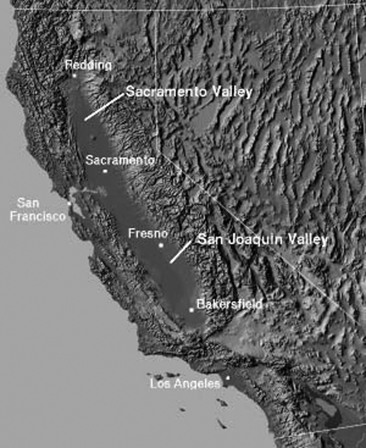
Map showing location of Sacramento Valley.
While mining (which included far more than gold) was the initial driver of the economy in California, development of agriculture quickly became the centerpiece of the government’s economic policy. As efforts to drain and reclaim land got underway in earnest, the number of geologists, hydrologists, surveyors, and engineers in the employ of government grew. The first catalyst for this process was passage, in 1850, of the ‘Arkansas Act’. 3 The law made it a ‘duty’ of the Secretary of the Interior of the US government to create an ‘accurate list’ of ‘swamp’ lands and grant them to the governor of Arkansas for distribution to farmers, the only requirement being that any proceeds resulting to the state ‘be applied, exclusively, as far as necessary, to the purpose of reclaiming said lands by means of levees and drains’. Before passage, the law was extended to all the states of the Union that contained such lands, with profound consequences for the course of state formation in California, which was admitted to the Union that same year. It was known from initial surveys of the Sacramento Valley that the state contained an enormous amount of acreage that could be claimed from the federal government on the basis of being swamp or overflowed lands. The newly formed government moved swiftly to take advantage of the Act, the governor stating that it granted almost all of the arable ‘public lands’ in California, upwards of 10 million acres (40,500 km2), to the state (McDougall, 1852: 15). Thus water was first constructed as a problem in California in terms of getting it off the land. So began the human designs to turn the Sacramento Valley into an agricultural powerhouse. Those designs, however, immediately confronted forces in the form of a series of devastating floods. Floods were a second sense in which water was constructed as a problem, in that it was now a matter of keeping it from sporadically returning to the former wetlands, though here I treat it as part of the same problem of swampland reclamation.
In 1861 a ‘State Board of Swamp Land Commissioners’ was created in an attempt to coordinate private reclamation efforts.
4
The legislation creating the board authorized the appointment of an engineer to make a survey and draw up a reclamation plan upon the petition of the owners of one-third of any tract of land ‘susceptible to one mode or system of reclamation’. This was the first time the discourse of ‘system’ entered into government designs for reclamation in California, and the first time such designs were linked to the idea of fitting the artificial to the natural. The result was the creation of ‘reclamation districts’ designed to incorporate entire ‘natural basins’ into singular administrative units. Linking the notion of administrative jurisdiction to ‘natural’ conditions would subsequently become a powerful discourse in support of statewide authority and system-building, and even at this early point, the ‘natural flow’ of water in the Sacramento Valley was used as an argument for greater coordination of local and private actors by state actors. The Swampland Commissioners ushered in the beginning of the use of administrative ‘districts’ in the state, jurisdictions that subsequently went on to form the fine-grain structure of governance and which (like ‘public utilities’) formally blurred the distinction between public and private. The creation of reclamation districts began a process of stitching the most local forms of governance to that of the state as a whole. In addition, because the land was granted by the federal to the state government, a new avenue of federal–state relations was created. The latter began in a somewhat contentious manner because the transfer of title to the state government was hindered by disputes over the extent of the swampland. Later in the century a discourse of ‘co-operation’ between ‘the state [California] and the government [federal]’ would emerge in the context of improving inland navigation and flood control. As the California commissioner of public works put it some four decades later:
It is particularly gratifying to be able to report that there is perfect accord between the Government Engineers and this Department as to plans for river improvement. These conditions have not existed before in the history of the State. California heretofore expended vast sums of money in making surveys, formulating plans and publishing reports thereon, but as a result of this expenditure nothing practical or beneficial was accomplished, owing to a failure to agree and a lack of co-operation between the State and the Government authorities. They agree now on all essential particulars, and this unity of purpose and concert of action will inure to the benefit of the State. (Leake, 1897–1898: 6)
Thus the first efforts at getting water off the land set the stage for a new set of articulations and relationality between levels of government that increasingly hinged on technoscientific and engineering matters concerning surveying and measuring, and the material construction and governance of earthworks for reclamation purposes. As ‘the state’ transitioned from a gathering of men framing a constitution, to a gathering of humans and non-humans in complex socio-technical relationalities, it began its formation into a specifically technoscientifc thing. As Latour has noted, such gatherings bring with them conflict (Latour, 2004). But they can also bring cooperation. Indeed the gathering of earthworks and levels of government around water-related issues illustrates an ongoing dynamic tension between the parts, and this is seen in later conflicts between state and federal elements. ‘Cooperation’, however, became a discursive staple of government reports and serves to counter the inherent conflicts that arise from complex gatherings of humans and non-humans.
The Swampland Commissioners were tasked with developing a valley-wide strategy for reclamation based upon a scientific reading of the natural flows of waterways and floodplains. Yet the capacity to execute the task was not yet in existence. None of the rivers in the valley had been metered and very little surveying had been conducted, so the commissioners did not have graphs and numbers to mobilize and align in support of such a plan. As Law points out (1992), networks short on aligned and stabilized non-humans tend to be weak. In addition, translating the interests of farmers into those of the commissioners turned out to be much more complicated than expected because there was no single ‘agricultural interest’ in the valley. Stock farmers opposed reclamation because it would ‘limit their range for cattle, horses, sheep and hogs’, and ‘some have fine farms that seldom are overflowed’. Others had ‘narrow fronts on the river and are unwilling to lose part of it to make way for levees’, and some were ‘unable or unwilling to raise the money for improvement’. 5 Some major reclamation districts whose boundaries could be aligned with the hydrography were created, the largest being 164,318 acres (665 km2). Apart from a few large projects, however, the design for a valley-wide system based on science and the material contours of the land made little headway. It was just too much to assemble at the speed demanded. Nonetheless this was the first example of the emergence of a dialectic of ‘resistance and accommodation’, a ‘mangling’ (Pickering, 1995) and reconfiguration of intentions in the context of attempts to come to terms with the way water in the Sacramento Valley had its own inclinations.
Localism, individualism, and the reconfiguration of governance
With complaints about the lack of progress by the Swampland Commissioners, new legislation passed in 1866 took a sharp turn toward local administration and private action. This again was a reconfiguration of governance within the context of a state. It was the constitution of private and local action by state government, rather than a shift from a state understood as a singular actor to an otherwise (naturally given) private domain. The Swampland Commissioners were abolished and all their district engineers discharged. 6 The swamplands were granted to the various counties, with the county surveyors becoming ex-officio engineers for the districts within each county. The County Boards of Supervisors, concerned only with reclamation within their own jurisdictions, authorized projects that gave little consideration to topography and hydrography, partly because they knew little of it, but largely because county boundaries had been already drawn with no consideration for the natural boundaries of water gathering basins. In order to ‘attract capitalists’ to spur reclamation, all limits on the amount of land an owner could hold were abolished. A burst of land speculation was unleashed and within 3 years almost all the swampland held by the state government had passed into private hands. Landholding and the material infrastructure of flood control were reordered as the work of assembling the state of California by state actors gave way to the development of a ‘web without a spider’ (Cumings, 1999). The consequences for the politics of water in California were profound. Reclamation by private owners proceeded with little or no regard for the natural inclinations of the water, or for the consequences for other settlers. Challenges to this new freedom of the individual to do as he pleased to protect his own property brought a new actor forcefully into reclamation politics: judges. Based on the claim that self-protection was an inalienable right, a judge found that landowners had complete freedom to construct earthworks to protect their own property without any concern for the consequences for others (Kelley, 1998). Categories of law increasingly became central to the discursive production of power relations around water (Alatout, 2007) in California, particularly between individual rights and the police power of the state, between case law and legislative law, and around the subject of ‘water [diversion] rights’.
Critical actants: Levees and meters
After this court ruling a ‘levee-building spiral’ began (Kelley, 1998). This fed the growing body of civil engineers migrating to the state. They came with all manner of experimental designs for earthworks and hydraulic modification, as well as visions of ‘system’ building and scientific management. The new landowners depended upon the skills of the engineers to build their levees, but they had little use for their grander visions of valley-wide systems. Hundreds of reclamation districts, encompassing anything from a few hundred to tens of thousands of acres, began building levee systems. Each effort to direct water away from one district or set of properties invariably directed that same water onto the property of others. The result was a predictable response and counter-response that reached crisis levels with landowners attacking and destroying each other’s levees (Kelley, 1998: 139–154). The levees were material cultural actants that embodied the designs and intentions of the human actors who built them. But they also had unintended consequences that acted upon other actors and agents just as surely as the intentional designs did. The material culture of the uncoordinated levees reconfigured agents and their interests, turning farmer against farmer. The levees as constructed embodied a specific set of beliefs, and as such they became ‘thick with politics’ (Bijker, 2007). But the levee battles that resulted only served to reinvigorate those actors–both agents of the state and some private landholders–who argued that only a ‘system’ that accommodated the nature of the land could prevent flooding. State actors quickly pushed back to become more centrally involved in reclamation and flood control. These agents enrolled the forces of inundating water, and the unintended consequences of the material actants aimed at controlling those forces, to remake the case for a systemic, state-coordinated approach informed by science. Ironically, the very success of the ‘every man for himself’ doctrine served to strengthen the hand of the would-be system builders.
By the end of the 1870s, in the context of the levee building chaos, there was a shift back toward more systemic engineering. In 1878 the Sacramento River Drainage District was created, and along with it a board of three commissioners who were given jurisdiction over all the swamplands of Sacramento and Solano counties, and most of Yolo county (an area encompassing the lower reaches of the Sacramento River). 7 That year a State Department of Engineering was also created. One of the first tasks of the new Engineering Department was to cooperate with the regional drainage district to ‘investigate’ the drainage plan. The district, county, state, and federal governments were now joined by a new form of regional jurisdiction. In this context a new actant entered the network. That actant was the meter, a material cultural form that is central to the culture and practice of technoscience (Carroll-Burke, 2001). For the first time in 1878–79, flow, stage, and current measurements were taken at various points along the Sacramento River and its tributaries. As the commissioner of public works later reported, a ‘hydrometric party made special topographic, hydrographic, and hydrometric surveys … . Gauging stations were also established … and the necessary surveys were made to facilitate the work of gauging these streams at their varying stages’ (Rose, 1895: 78).
Of course the stability of meters is relational with respect to metrology and all that entails. The material metering technologies and the social and political order of standardization are co-produced. Thus metering the rivers was by no means a straightforward affair. Numerous metering devices such as floats, double floats, current meters, and tide gauges were required (Rose, 1895: 77–138). Experiments were conducted with different meters where results were compared and instruments calibrated. Current meters were particularly complex and delicate and required trained observers and multiple measures. Locations of metering stations had to be determined, and measures had to be taken between the banks, at points of discharge from tributary streams, at the surface and below. Both slow- and fast-moving waters generated specific challenges for the meters. And the hydrometric party in the field had to be coordinated with an office of computations and records. Indeed, to say that the rivers were ‘measured’ is to say that a delicate actor-network was established, a network composed of agents, actants, and forces that required tremendous work to hold together. Nonetheless, once a human agent has a stabilized meter in hand, it can be employed with powerful effect (they can even sometimes become ‘dictators’; see Loftus, 2006). Meters may have different significance in different relational contexts, but they also have a relatively inherent and trans-local significance in terms of their capacity to transduce phenomena into number, and thus generate comparative numerical records (Carroll-Burke, 2001). They bring order to disorder, regulation to chaos. This is their special power, and this explains why they are so ubiquitous in both technoscientific practice and technoscientific states. Meters became powerful actants in the emerging actor-network that was being built around water problems in California, furthering system designs by aligning them with graphs packed with numbers and under the authority of the state government. For all intensive purposes, the rivers became what the government engineers said they were. They were part of a natural hydrological system. They could only be controlled by an artificial hydraulic system. And only state government, the logic went, could know the former and build the latter.
Hydraulic mining and system builders
The new Engineering Department was also tasked with investigating how ‘hydraulic mining’ was impacting agriculture. Hydraulic mining constituted water as a distinct relational object with little or no direct connection to what water was in the context of reclamation. Hydraulic mining was a technique developed in California that involved capturing water upstream from the mining site and transporting it by sluices downhill, where it was funneled into hoses and then released at great force through ‘water cannons’. The force of the water blasted away entire hillsides from which the gold was then recovered. The soil and gravel and other ‘debris’ washed away by hydraulic mining flowed downstream and eventually blocked the river channels, hindering navigation and causing the water and the debris to overflow onto agricultural land. Though unintended, the debris became a powerful actant, reconfiguring agricultural interests. Whereas the free-for-all of levee-building had turned farmer against farmer, the mining debris acted to create a more (but not completely) unified agricultural interest in opposition to mining interests. The state engineer reported that some 44,000 acres (180 km2) had been destroyed, conservatively valued at almost $3 million (Hall, 1880). In his message to the legislature in 1880, Governor Irwin referred to the ‘irrepressible conflict’ that had emerged between mining and farming (cited in McClure, 1927: 147). A state ‘Debris Commissioner’ was created in 1893, but his responsibilities were largely confined to impounding debris upstream with dams. That same year brought the creation of a federal ‘California Debris Commission’ (CDC), which was to investigate the possibility of restoring the rivers to effective navigability and assessing whether hydraulic mining could continue (it had been largely halted by court injunctions from the early 1880s). 8 Also that year, a new state ‘Department of Public Works’ was given the task of investigating flood problems and proposing engineering works to mitigate them. Reframing reclamation as public works strengthened the hand of the system builders since such works were widely accepted as proper to state government. As Espeland has noted, public works were ‘emblems of state power’ (1998: 61; see also Carroll, 2006). At the same time some of the farmers, who had organized an ‘Anti-debris Association’, lobbied the federal government for relief. An array of agents, actants, and forces were now converging in a way that would accelerate the assemblage of the state as a technoscientific thing.
At this time, the federal government’s jurisdiction and responsibility in the context of water was largely restricted to navigability of rivers and ports. However, a new State Board of Drainage Commissioners explicitly linked the issue of navigation with those of reclamation and flood control. Created in 1880 and comprised of the State Engineer, the Surveyor General, and the Governor, the remit of the Commission was to comprehend statewide drainage plans, and it was granted the power to divide the entire state into drainage districts based upon ‘natural’ drainage patterns. The Commission made the connection by arguing that the debris both caused the flooding of reclaimed land and hindered navigation of the Sacramento River. Thus the debris acted to support the argument for a coordinated state system. Linking the mining debris issue with reclamation, flood control, and most importantly navigation, created the context for the federal government to become more involved.
Water thus became a multifaceted relational object in late-19th-century California. What water was, and how it was conceived as a problem by government, shifted across the different contexts of navigation, reclamation, and mining (and increasingly irrigation/water rights too). But these distinct ways through which water was understood increasingly came into contact, and sometimes into conflict. This created opportunities for government engineers to further their case that local actors could not be trusted to comprehend how their actions related to the actions of others or to the character of the country. Thus the new state public works commissioner complained that individual property owners and local reclamation districts had ‘no conception of the fact that the works they were endeavoring to construct and maintain, were parts of the great arterial drainage systems of valleys receiving the flood waters of 57,000 square miles [150,000 km2] of mountain and rolling land’. 9 The ongoing cycle of floods compelled recognition, according to the commissioner, that the ‘systemless efforts’ of the past had failed by producing results that lacked ‘unity of action’. As the gathering of topographic, geographic, fluvial, hydrographic, and geological data by government agents grew in the late 19th century, it became increasingly difficult to counter arguments that based the need for a statewide system on appeals to the natural condition of the country. It was argued that local problems had to be understood in terms of the watershed as a whole, and only state government possessed such understanding.
Articulating water problems and enrolling allies
A devastating flood in 1904 prompted a new state engineering investigation to draft a plan for both flood control and navigation improvement for the Sacramento and San Joaquin rivers and their tributaries. Known as the Dabney Commission, the engineers reviewed the ‘large mass of printed and written data’ that had already been accumulated to that point (Dabney, 1905: 12). Within a few months a report was issued that called for containing all the floodwaters of the Sacramento within its banks by way of levees (the ‘levees only’ doctrine that ruled the US Army Corps of Engineers (USACE)). The plan was based upon the measures of river discharge during the 1904 flood, the largest flood for which measurements were available. The plan was adopted but before work began an even greater flood occurred in 1907. The amount of water that required channeling to prevent floods was a critical matter of debate and disagreement. The Dabney Commission had rejected a number of estimates as inflated, even ‘impossible’, and drew up a plan based upon a total outflow of 250,000 cubic feet per second (7,080 cubic meters per second) (Dabney, 1905: 33). During the 1907 storms, however, the USGS reported measures of 600,000 cubic feet per second (17,000 cubic meters per second) (Kelley, 1998: 277). Though the meters could only generate estimates, it was difficult to characterize such a huge disparity as a measurement error, and the new figures decisively shifted policy in favor of an even more elaborate system of control that abandoned the idea of containing all the flow within levees. The human agents of the USGS, the natural forces of the weather, the uncoordinated material culture of private levees, and the now powerful actants made up of meters and ‘gauging stations’, all became allies of the advocates of a complex and integrated state controlled project. But while the USGS meters buttressed state plans, enrolling the federal government in the execution of works was more difficult, and hinged on linking reclamation and flood control with inland navigation. Indeed, to the extent that water was a relational object for the federal government, it was mostly in terms of navigation, despite pioneering work by the USGS in metering the country’s rivers.
In 1897, a state ‘Auditing Board to the Commissioner of Public Works’ had been created, and granted $300,000 for drainage improvement and ‘rectification’ of river channels.
10
Here the state government began to take on the navigation problem itself, and in doing so, linked that problem directly to the problem of reclamation, thus setting the stage for translating the interests of the federal government into those of the state of California. It also signaled the beginning of what would quickly become settled state policy: that all three problems were a matter for state government and were not to be left to the federal government, local districts, or county governments. In 1907, the Department of Public Works was abolished and replaced by a new State Department of Engineering.
11
The new department consolidated and centralized the powers of public works, the auditing board, the Department of Highways, and the State Debris Commission. Engineering was now firmly institutionalized within government and government engineers were most likely to see a water problem with many facets to it, rather than a set of distinct problems variously connected with water. Meanwhile the federal government also extended its role through engineering investigations and surveys, and these too began to link water issues into one object/problem. This process accelerated at the federal level with the creation, in 1902, of the Reclamation Service (becoming the Bureau in 1907) within the Department of the Interior. Initially headed by a USGS engineer, the service linked a range of problems together, including forestry and how it related to drainage. As the head of the service put it in 1905, the ‘theory that we are proceeding on is that the entire problem of forestry, irrigation and drainage, and the prevention of overflow should be considered in one harmonious whole’.
12
Similarly, one of the three duties of the CDC, in addition to improving navigation and investigating whether hydraulic mining could be recommenced, was to ‘afford relief in flood time’.
13
‘Relief’ was not, however, generally interpreted to mean that the federal government should be directly engaged in building or paying for flood-control infrastructure to prevent flooding. Within the federal government the flood problem was still widely viewed as distinct and separate from the navigation issue: ‘the problems of navigation are only incidental and are entirely independent [from drainage, flood control, and reclamation]’.
14
Yet in 1910, the CDC, made up of three engineers from USACE, forcefully tied the issues together. After 5 years of technoscientific investigation the ‘Jackson Report’ stated that:
[the] interests of navigation, debris control, and flood control in the case of this [Sacramento] river are so inseparably connected that it is thought that they should be considered under one general project, thus utilizing to the fullest extent and for the common good any work done under projects of improvement of navigation, control of debris, or control of floods.
15
At this point the state and federal governments were already ‘co-operating’ on actual earth works related to navigation but which served flood control as well. Both governments had appropriated $400,000 each for the operation of two large steam suction dredges to begin removing debris from the lower Sacramento River, making drainage cuts, and building levees. But the CDC went even further in terms of making water an object of government. The USGS meters had registered more than twice the amount of water discharge than previously thought, and on this basis the commission concluded it was practically impossible to contain the river within levees. The commission recommended abandoning efforts to contain the river within its banks, and instead build a ‘bypass’ (or spillway) flood system, a system that only state government could build. Thus the three members of the CDC, and in particular its young leader Captain Jackson, became critical agents in the eventual adoption of a state-government-built and controlled, valley-wide flood control system. Jackson’s recommendation was remarkable in that it stitched the different problems into one problem, directly contradicting his corps colleagues who only a few years earlier reported that reclamation had nothing to do with navigation, and was therefore not a matter for the federal government. And he advocated a bypass system against the long reigning ‘levees-only doctrine’ that ruled USACE. Just as weather, rivers, and other forces shaped outcomes, and meters, levees, and debris became critical actants, some humans became key agents by acting contrary to the prevailing wisdom or orthodoxy.
The Sacramento Valley Flood Control Project
The new project (see Figure 2) became the first major system that served to stitch together more powerful forms of state government organization through the material cultural infrastructure. It involved the construction of six bypasses and weirs. The Sacramento weir alone cost over $1 million and was 2000 feet (600 m) wide. Levees along the bypasses totaled almost 200 miles (320 km). Two major drainage canals and over 500 miles (800 km) of riverbank levees were constructed. An equal part of the project was a new powerful organization, the State Reclamation Board, created in 1911 to implement the plan and administer the system. The board was granted what was ‘frequently termed its police power’, giving it the full authority of government to compel landowners to comply with the plan. 16 It also had a considerable taxing power. The CDC estimated the total cost at over $33,000,000, one-third of which was to be paid by assessments on landowners. The state and federal government were each supposed to contribute a third, but the federal agencies contributed considerably less on the basis that it could only fund parts of the project directly related to navigation. In the end the project cost closer to $100,000,000.

Floods of 1915 (in basins) juxtaposed with by-pass flood plan. Reproduced from Anonymous (1915) with permission from California State Library.
By all accounts, the system was mired in controversy and besieged by litigation, but by the late 1940s was largely complete. All the local newspapers editorialized in its favor. V.S. McClatchy’s Sacramento Bee (McClatchy was president of the Reclamation Board) stated that the project was a solution to the problem of ‘warring reclamation owners’. The editors set the ‘absolute futility of independent protective efforts’ in contrast to the imperative of ‘the only plan which spells safety for all’. ‘Government engineers and all other competent authority’ had concluded that ‘only the [bypass] flood control project can control the river and save the valley’. 17 The Sacramento Star proclaimed that ‘State-wide control is … as inevitable as the tides. Nothing, humanly speaking, can possibly prevent it.’ 18 The problem of flood control, they explained, had been investigated and studied for over 30 years and the Reclamation Board was now engaged in the ‘scientific reclamation of the largest possible area of land’. They critiqued the ‘senseless system of building against each other and fighting through the courts’, and declared that the ‘system cannot be a thing of shreds and patches. It must be constructed as one big system’. 19 The Sacramento Union expressed the view that the ‘engineers of the Federal Government declare it is right. The engineers of the State reclamation service say it is right, and that it will help and not hurt the farmers. And there you are.’ 20 Thus the conflict over the valley-wide flood control project resulted in a sharpening of the argument for systemic planning, legitimated government designs through reference to engineering credibility, created a powerful counter to claims based on private property rights and localism, and thereby strengthened the case for the expansion of state government power in cooperation with the federal authorities.
The bypass flood project was a massive government and technoscientific endeavor. Adoption of the project marked the most important moment to date for the articulation of the practices of government and science in California. By linking the problem of reclamation to those of navigation and debris, it set the stage for water to become a fundamental boundary object that in turn constituted a new liminal zone between science and governance. Of the three problems the project tackled, water was the common denominator, and as such could serve as the point of articulation. Articulation resulted in a number of smaller problems being turned into one big problem. Quite independently another development was occurring that would complete the process, and also draw in other problems.
‘Water’ becomes an object of governance
Jamie Linton has insightfully focused on how water was constructed as a ‘resource’ in a 1909 article by W.J. McGee, a leader of the conservation movement and a confidant of President Theodore Roosevelt (Linton, 2006: 2; McGee, 1909). The article, titled ‘Water as a resource’, is the first to lay out a detailed argument that water, in a multitude of ways, should be an object of scientifically informed governance, and that it was government’s responsibility, indeed duty, to use science to control and exploit water. Linton asks why water ‘suddenly’ became a resource, answering that:
[the] deliberate naming of water as a resource, I think, needs to be seen in the context of scientific, economic and political circumstances that comprise the conservation movement in the United States during the first two decades of the 20th century. In essence, it was at this time and in this context that water became known to the state in a way that made it an object of calculation … . (Linton, 2006: 3)
Linton, I believe, has made a critical observation here. The naming of water as a resource had profound consequences for its constitution as a relational object with respect to the joint forces of technoscience and governance. The exploitation of resources always involved the conceptualization of some aspect of nature as something to be controlled and/or extracted. I would only nuance Linton’s argument to say that the way water became known to the state government was not quite so ‘sudden’. In California the Commissioner of Public Works used the language of ‘water resources’ as early as 1898. In addition, water was sometimes included under the generic term resources (with land, minerals, and so on) as early as the 1880s. As with flood control, water was often subsumed under more specific terms, as when Governor Bigler spoke, in 1853, of the ‘development of the agricultural … resources’ of the state (Bigler, 1954). In addition, water was an object of calculation and scientific investigation quite a bit earlier, the Sacramento River being metered as early as 1878. Indeed a considerable amount of quantitative data relating to the rivers and hydrology of the state had already been accumulated by the beginning of the 20th century.
Water was an object, if at first only indirectly, of state government in the Sacramento Valley first in terms of reclamation and flood control, then in relation to hydraulic mining, and finally navigation. As indicated earlier, a fourth instance in which water became an object of state government in California was irrigation, beginning in the 1880s, but not in terms of actually building infrastructure until the 1930s. Thus while I agree that the highly articulated conceptualization of water as a resource was key in that it provided for the discursive punctualization of an array of problems under one word, singularizing a plurality of problems, this was already occurring in practice as the different problems related to water were being linked together, as in the case of reclamation, debris, and navigation. Development and irrigation furthered the process through which water emerged as an object of government. So too hydroelectric power. Linton notes that hydroelectric power ‘alone … is unlikely to account’ for the conceptualization of water as a resource. Indeed McGee ranked power generation as subordinate to water supply, navigation, and irrigation (McGee, 1909: 49). Yet it was one more sense in which water became a concern of government. I suggest that it was this plurality of problems related to water that was key. All of the problems (and opportunities) related to water increasingly impinged upon each other and this created the context for the emergence of water as the problem.
Furthermore, in the California case the system builders, those most likely to argue that the plurality of water problems were interconnected and that, therefore, only state government could comprehend and solve them, emerged from the reclamation struggles emboldened. Powerful organizations of government were already in place and officials were in the field, engaged in investigations. Metering devices were developed over a number of years through an experimental process and gauging stations were already established. Official narratives of accomplishment were institutionalized. Hydrological graphs, maps, and meters had proliferated. A great deal was known about the hydrology and topography of the state. Finally, and perhaps most importantly, a new ‘engineering governmentality’ was institutionalized. Engineering governmentality translates problems of governance into problems of engineering, and vice versa. It is distinct from notions of rationalized government. As an empirical matter, it emerges prior to discourses of rationalization, which is better thought of as an overarching high-modern ideology (Scott, 1998: 4), which reaches its highest level of power in the early 20th century. Engineering governmentality, on the other hand, directs attention to the concrete practices and materialities around which government and engineering co-jointly act. It captures a world that is less about visions of perfection and more about pragmatic approaches to particular problems. In the case of the Sacramento Valley Flood Control Project, the emergence of the high-modern ideology of rationalization did come to be expressed by some engineers, and this no doubt further supported grand schemes to tackle ‘the state’s water problem’. But engineering governmentality remained oriented toward ongoing practical works largely free from hyperbole. It became part of the mundane and everyday process of governance.
Conclusion
It is in the context of all these historical forces, all this momentum, that the conceptualization of water as a resource gained its significance. ‘Water’, in a very real (if constructivist) sense, emerged as an object of government through a historical process. This paper has focused only on California. I have sought to document the specificity of that process in this case. As indicated earlier, there were wider contexts, such as the culture of reclamation, the logic of engine science, national expansionist ambitions, and the emergence of the conservationist movement, that transcend and partly explain the Californian case. But I have also suggested that studies framed by the regional context of ‘the west’ have occluded the specificity of the Californian case, particularly by folding it into the story of watering the deserts. And as indicated earlier, this is by no means an origins story, as the agents of engineering governmentality in California never tired of pointing to contemporary works in other countries to justify their plans. Indeed these agents relied upon a genuine origins story, regularly referencing Egypt, Rome, Babylon, and so on (see note 1), to suggest that reclamation through drainage was practically co-extensive with the origins of human civilization.
About a decade or so into the 20th century, politicians and engineers were making general ‘water plans’ that encompassed reclamation, flood control, drainage, navigation, irrigation, salinity control, urban and industrial needs, and power generation (and later recreation). In California a ‘State Water Problems Conference’ was authorized as early as 1915, and a year later published a report on ‘all [water] problems from the state’s point of view’ (State of California, 1916: 8). ‘Conservation’ was represented at the conference, but what is critical is the way representatives of all the problems related to water that had emerged over the previous 60 years were now assembled together.
[For the] purpose of considering and recommending a unified state policy with reference to irrigation, reclamation, water storage, flood control, municipalities, and drainage, with due regard to the needs of water power, mining, and navigation, the governor of the state is hereby empowered to call a conference of properly qualified persons, consisting of … the chairman of each of the committees of … the state legislature on irrigation and on drainage, swamp, and overflowed lands, the state engineer, the chairman of the state water commission, the chairman of the state reclamation board, the chairman of the state conservation commission, the secretary of agriculture, and six others to be appointed by the governor. (State of California, 1916: 5)
Water was now a problem in multiple and sometimes contradictory ways, gathering together diverse interests around what was becoming the singular obligatory passage point of ‘the state’. The story from this point gets even more complex, because while the word ‘water’ introduced a certain simplicity by punctualizing a plurality of problems, the object it designated was no longer a simple uncontested object ‘out there’, a matter of fact, but a highly complex matter of concern ‘in there’ (Latour, 2004). The subsequent building of the Central Valley and State Water Projects would have been unthinkable in the absence of both the gathering and punctualization that had already been engineered around water. Yet there was nothing inevitable about these projects. They cannot be said to have had their origins in the Sacramento Valley any more than in ancient Rome. But circa 1915 marks a shift from a halting process in which the agents of state government struggled to act in a coherent way to make the developing infrastructure accommodate and align with the natural, to a period when state and federal government held visionary command over the single and all encompassing ‘problem of water’.
The Central Valley Project was the largest infrastructure of any kind in the world at the time it was built. And the State Water Project remains the largest infrastructure built by any state government in the union. But despite the absence of awe-inspiring dams, pumping stations, and aqueducts, the Sacramento Valley Flood Control Project was a critical state government achievement. It was the first of the large projects that together reveal a stunning example of a modern technoscientific state built into and out of water infrastructure. Technoscientists in the employ of government populate this technonature and techno-territoriality at every point, from hydrologists to fish and plant biologists (regardless of the fact that the people of the state are largely unaware of it). The technoscientific state is revealed as a thing, a complex assemblage of humans and non-humans, a discursive, organizational, and material formation, a politically engineered technonature. It is a complex actor-network rather than a singular actor in the image of a human being. However, the very complexity of the technoscientific state, its gathering together of so many actors, makes it an obligatory passage point for those actors. In this context ‘the state’ is constantly punctualized as a singular actor ‘out there’ and apart from the humans from which it was built and of which it is partly composed. Paradoxically, its very formation into a complex assemblage fuels the iterative process of discursive singularization.