



Abstract
The Panama Canal requires an enormous volume of fresh water to function. A staggering 52 million gallons are released into the Atlantic and Pacific oceans with each of the 35–45 ships that transit the canal daily. The water that facilitates interoceanic transportation and global connection falls as rain across the watershed surrounding the canal and is managed by an extensive system of locks, dams, and hydrographic stations. These technologies – which correspond with the popular understanding of infrastructure as hardware – were largely constructed during the early 20th century. Since the late 1970s, however, administrators and other concerned actors have responded to actual and potential water scarcity within the canal system by developing a managerial approach that integrates engineered technologies and new techniques of land-use planning and environmental regulation across the watershed. Through this process, techno-politics and environmental politics have become increasingly inextricable in the transit zone. Whereas canal administrators previously emphasized the control of water in its liquid state, watershed management emerged as an attempt to manipulate water flows through the legal protection of forests and restriction of agriculture. As forested landscapes have been assigned new infrastructural functions (water storage and regulation), campesino farmers have been charged with a new responsibility (forest conservation) often at odds with their established agricultural practices. Consequently, I bring together scholarship on infrastructure in science and technology studies and political ecology in anthropology and geography to examine why, how, and to what effect landscapes around the canal have been transformed from agricultural frontier to managed watershed. I suggest that the concept of infrastructure is a useful theoretical tool and empirical topic for analyzing the politics of environmental service provision. By paying attention to the contingent history of engineering decisions and the politics embedded in the changing socio-technical system that delivers water to the canal, we can better understand the distributional politics of environmental service provision in Panama today.
This essay explores the notion that nature is – or might become – infrastructure, delivering critical services for human communities and economies. Put simply, this is the idea that forests, wetlands, reefs, and other landscapes, if appropriately organized, deliver services (water storage, purification, and conveyance; flood alleviation; improved air quality; climate regulation; and so on) that facilitate economic activity and development. It may seem peculiar to refer to landscapes or landforms as infrastructure, a term often reserved for roads, railways, and power lines. Infrastructure implies artifice; nature typically signifies its absence. However, as a growing literature in anthropology (Balee, 2006), geography (Denevan, 1992), and environmental history (Cronon, 1995) suggests, nearly every environment worldwide has been modified through human labor. Work, then, blurs the nature–technology boundary, suggesting that a neat division is illusory (Reuss and Cutcliffe, 2010; White, 1995). Moreover, the concept of infrastructure does not delimit a priori which – or even what kind of – components are needed to achieve a desired objective. In practice, disparate components are integrated and become a networked support system through what Geoffrey Bowker (1994: 10) calls ‘infrastructural work’, a set of organizational techniques (technical, governmental, and administrative) that create the conditions of possibility for a particular higher-order objective. In this essay, I develop an infrastructural approach for analyzing the practices, politics, and dynamics of environmental service delivery.
As infrastructure, nature is irreducible to a non-human world already ‘out there’. It must, in its proponents’ terms, be built, invested in, made functional, and managed. This is an active and inherently political process. As nature becomes infrastructure through work, human politics and values are inscribed on the landscape, much as they are embedded in arrangements of steel and concrete (Winner, 1980). Through this process, techno-politics and environmental politics become inextricably intertwined. As a landscape becomes infrastructure for one system of production, rather than another, a different group of environmental services (purposefully selected from a multiplicity of possibilities) becomes relevant. In a peculiar inversion, the landform may then be reverse engineered to meet the demands for the prioritized service(s).
The Panama Canal is an illuminating site to think about infrastructure, natural and otherwise. Five percent of global commerce moves through the canal’s lock and dam system (US Agency for International Development, 2005: 1). Interoceanic transportation, the higher-order objective that defines the canal, is made possible by a water management system that delivers the enormous volume of liquid necessary for 35–45 ships to transit the locks every day. Fifty-two million gallons of fresh water, equal to the daily domestic consumption of approximately 500,000 Panamanians, 1 are released into the oceans during each of these transits. Thus, the maximum number of transits possible is limited by available water volume, among other constraints. The canal depends on fresh water that falls as rain across the surrounding watershed, 2 a 1077 square mile (Ibáñez et al., 2002) hydrologic basin drained by six major rivers (see Figure 1). That water is managed by a ‘traditional’ engineered infrastructure comprised of locks, dams, reservoirs, and hydrographic stations. These technologies – which correspond with the popular idea of infrastructure as hardware – were largely constructed and networked during the early 20th century. Since the late 1970s, however, canal administrators from the US and Panama have responded to actual and potential water scarcity by developing an integrated management approach that combines existing technologies with new techniques of land use planning, environmental regulation, and community-based management. I analyze this socio-political work of water provision – especially the management of forests and farmers in the canal watershed – in order to explore the stakes of making natural infrastructure.
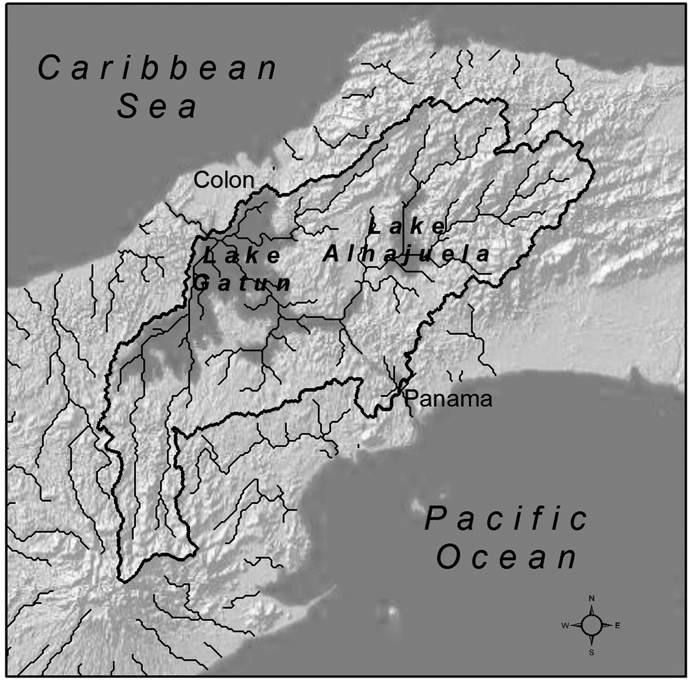
The Panama Canal transit zone, including: the canal watershed (bounded with a bold line), Gatun Lake, Lake Alhajuela, and the canal terminus cities of Colon (Caribbean) Panama City (Pacific).
The essay is organized in four sections. First, I develop a conceptual framework for studying nature as infrastructure. The material that follows is a case study drawing on 18 months of archival and ethnographic research in Panama and the US. Second, I examine the organization of a network of civil engineering and hydrographic technologies around the Chagres River. Collectively, these technologies transformed a potentially volatile river system into a generally manageable water source for the canal. Third, I examine the establishment of the Panama Canal watershed as an administrative region during the transfer of the canal and Canal Zone from the US to Panama in the decades after the 1977 Canal Treaties. Whereas canal administrators had previously emphasized the control of water in its liquid state, watershed management emerged as an attempt to manipulate water flows through the legal restriction of agriculture and protection of watershed forests. Thus, watershed management can be understood as a relatively recent manifestation of the ongoing project of reorganizing Panamanian landscapes and populations to optimize water delivery. I conclude by discussing the cultural politics of natural infrastructure.
Nature as infrastructure
Infrastructure is the collective term used to describe the subordinate parts of a ‘higher’ system. The word, first used in English in 1927, came from French, where it referred to the substrate material below railroad tracks (Oxford English Dictionary, 1991). The prefix infra- means below, beneath, or within. Structure has various meanings and, of course, carries significant intellectual baggage, but might be defined as the relation of the constituent parts of a whole that determines its character (Oxford English Dictionary, 1991). The term infrastructure is widely used in economics and planning, where it refers to capital investments that facilitate directly productive economic activity or development (Lee, 2009: 382–383). In vernacular usage, infrastructure often refers to artifacts built of concrete and steel: the ‘hard’ technical systems that facilitate the distribution of people, energy, water, waste, information, and so on. However, the use of the term has expanded rapidly in recent decades as it has been deployed in a variety of new fields. Infrastructure still refers to hardware, of course, but the term also increasingly evokes the ‘soft’ social systems assembled to support education (Twigg, 1994), governance (Globerman and Shapiro, 2002), and public health (Baker et al., 2005). In the case of natural infrastructure, as in these examples, emphasis is placed on the functions, benefits, or services that a subordinate system delivers, rather than the type or character of its individual components. Thus, I argue that work – specifically the organizational techniques through which components are networked for service delivery – is a useful analytic tool for examining relationships defined in terms of infrastructure.
What railroad tracks and public health clinics share, despite their obvious differences, is that they are obviously built by and for people. Landforms, by contrast, are less obviously constructed and have only been explicitly described as infrastructure over the last decade (see, for example, Benedict and McMahon, 2006; Smith and Barchiesi, 2009). This shift in managerial rhetoric and practice is associated with a broader interdisciplinary effort since the 1980s to assign the environment value as natural capital: a stock that provides ecosystem services that benefit humans at multiple scales (Costanza et al., 1997). As a corrective to the assumption that the environment has no economic value and, by extension, that its degradation has no social cost, reconceptualizing nature via service delivery is presented as a market alternative to state regulatory approaches that are incapable of dealing with multi-scale environmental problems. At the same time, scholars have suggested that the establishment of ecosystem service markets may also have adverse social and economic effects for rural people (Corbera et al., 2007; McAfee and Shapiro, 2010). In this essay, however, I bracket these important debates and emphasize how historically contingent socio-technical systems shape which environmental services become valuable and who benefits from their delivery. My study of Panama in the 1970s and 1980s emphasizes the role of the state, but my focus is neither on the market nor the state, per se. Building on the work of Nigel Thrift (2006) and Timothy Mitchell (2007), I approach capitalism and the state as effects of the socio-technical platforms that give them such obduracy and vitality.
My analysis of water management in Panama builds on work in infrastructure studies. 4 The genealogy and key theses of this literature in STS have been outlined elsewhere (Star and Ruhleder, 1996: 113), so I will only highlight a few points central to my argument. First, STS research on infrastructure arguably emerged in the wake of Thomas Hughes’s history of electrification and the development of large technical systems (1983, 1987). Large technical systems scholarship posits that technologies, or artifacts, should be understood as components of the socio-technical systems that support and sustain them (Coutard, 1999; La Porte, 1991; Mayntz and Hughes, 1988; Summerton, 1994). Bowker, Edwards, Star and others have theorized infrastructure as a useful conceptual bridge between these macro-scale studies and the actor- or artifact-centered approaches advocated in social construction of technology (Bijker et al., 1987) and actor network theory (Callon, 1986; Latour, 1983) approaches. While the large technical systems approach tends to emphasize top-down, unified organization by system builders, the infrastructure studies approach is less hierarchical. Infrastructures are conceptualized ecologically, which is to say that they are understood to come into being, persist, and fail in relation to the practices of the diverse communities that accrete around them (Star and Ruhleder, 1996). They are shaped by, yet also exceed, the intentions of their builders. Grounded in everyday life, infrastructures become revealing sites for ethnographic research on negotiation, struggle, and meaning (Star, 1999). I argue that we extend this insight to environmental service provision, which can be analyzed at the intersection of emergent environmental problems, historically specific socio-technical systems, and everyday life in neighboring communities.
Infrastructure studies scholars recognize that technology is political (Winner, 1980), but the politics of infrastructure may be difficult to see. In modern life, people often experience infrastructure as ‘behind the scenes, boring, background processes’, operating unnoticed in the absence of breakdown (Bowker and Star, 1998: 234). But, of course, they are not invisible to everyone, everywhere. Visibility is situated, reflecting an actor’s geographical location, cultural assumptions, and the nature of his or her labor (Star and Ruhleder, 1996: 113). As technical systems cross social, economic, and geographical boundaries, they are experienced differently and affect human groups differently. This is to say that one actor’s background infrastructure (for example, a functional Panama Canal for shipping companies) remains a persistent problem for those ‘behind the scenes’ (the engineer, mechanic, and, as we will see, the Panamanian farmer). For this reason, Bowker and Star (1998: 234) urge us to conduct ‘infrastructural inversions’, recovering the world-ordering arrangements embedded in the systems that many of us take for granted. In summary, STS scholars have conceptualized infrastructure as a large technical system, ecology, and site of political struggle, but the relationship between socio-technical systems and the non-human environment has received less sophisticated attention.
On the one hand, the environment is treated as ‘an assumed background of natural forces and structures’ (Edwards, 2003: 194). Seen this way, the environment may be harnessed by, or set parameters for, a system, but remains outside of it. On the other hand, socio-technical systems may themselves constitute an artificial or built environment constructed and deployed by humans. Here, the variability of nature is channeled and mediated for human use, comfort, and convenience (Edwards, 2003: 189). Environments managed for the purposes of service delivery fit neither framing. On the one hand, these landforms are ‘natural’ because they are shaped by processes beyond human control, but they are also sites of management and investment for actors seeking to optimize the delivery of services once assumed to exist in the background. Below, I show how infrastructure studies might be combined with political ecology and other critical scholarship on the environment to analyze the politics of making natural infrastructure.
Political ecology explores the complex ways that human groups know, access, and struggle over the environment in multi-scale or networked power relations (Robbins, 2005). Although building infrastructure is rarely framed as a political project by its promoters, new infrastructures inevitably threaten to alter or eradicate existing ways of life. Similarly, making natural infrastructure has significant potential to produce ecological distribution conflicts around socially and spatially asymmetrical access (Guha and Martinez-Alier, 1997). These conflicts often turn on material landforms and land cover – the infrastructure itself – but, more fundamentally, they raise questions about which among a multitude of potential environmental services are to be emphasized and delivered and, crucially, whose societies and economies those services support.
The distribution of benefits and costs associated with making natural infrastructure is a question for site-specific empirical research. At best, ‘local’ human communities may become ‘partners’ in environmental service provision, and benefit economically. At worst, planners and environmentalists assume that physical work with nature is inherently destructive and attempt to block some communities’ access to natural resources. Although the Panama Canal watershed has not, to my knowledge, been explicitly characterized as infrastructure, administrators do emphasize the infrastructural functions – primarily water storage and regulation – that the drainage basin provides. In the case of provisioning the Panama Canal with water, the forests that became a concern for water managers were not uninhabited natural areas, but landscapes already morally, economically, and ecologically bound up in agrarian life. Therefore, natural infrastructure has been constructed across human groups who know and interact with the forest in different ways. Watershed administrators, I will argue, have sought to reshape human–environment relationships so as to optimize the delivery of one class of environmental services (water storage and regulation), while campesino farmers have sought to optimize another (nutrient cycling). Political ecologists have insisted not only that we ask ‘what nature?’ but also ‘whose nature?’ (Escobar, 1998). In this case, we might also ask, ‘whose natural infrastructure?’
Assembling the Panama Canal
The most obvious place to see the Panama Canal in action is the Miraflores Locks Visitor Center, located in the former US Canal Zone near Panama City. The Miraflores Locks are one of three sets of locks (the others are the Gatun Locks and Pedro Miguel Locks) that raise ships from sea level at one ocean up to Gatun Lake at 85 feet and lower them back down to sea level on the other side of the isthmus in, on average, 8 to 10 hours. From a three-tiered viewing deck, visitors watch a slow parade of container ships, oil tankers, and cruise ships pass through locks built a century ago. Here, crudely, is how they work. Ships are raised and lowered in the locks through the use of water, gravity, and technology. First, a ship slides into the lock chamber and massive steel gates swing slowly closed. Then, a lockmaster opens valves in a water storage reservoir located above the locks. Water surges through culverts the size of subway tunnels in the concrete chamber walls, enters cross-culverts beneath its floor, and then erupts upward, lifting a ship and its cargo. Visitors to Miraflores Locks see only one node of the expansive canal system, but even this suggests the coordinated social and technical work that makes transportation across Panama possible. Less obvious from this vantage point, however, is the quotidian environmental management that administrators now conduct in order to move ships.
On small farms as far as 25 miles upstream from the shipping lane, forest guards working for Panama’s national environmental agency (ANAM) inspect the secondary growth of grass, bushes, and young trees that rural Panamanians call rastrojo in order to determine when it is legally defined as forest and, therefore, protected by the state to ‘produce’ water for the canal. 5 Integrated watershed management began after the signing of the Canal Treaties of 1977, which guaranteed Panama control of the canal after 1999. Canal administrators, natural scientists, state functionaries, and others collaborated to establish the watershed as a political–administrative space for water management. Forests formerly located in the Republic of Panama and beyond the boundary of US Canal Zone became sites of struggle as the watershed was unified under Panamanian control and rural agriculturalists were scripted as a potential threat to transportation.
How did watershed forests become natural infrastructure serving the canal and, by extension, global commerce? The case study that follows focuses on water management in the late 20th century, but neither the emerging experience of water scarcity during that period, nor its proposed solution – watershed management – can be understood without a discussion of the development of the large technical system still in use today. The water management components of that system include the following: three sets of locks, three dams, three water storage reservoirs, and a network of remote hydrographic stations from which measurements of rainfall and changes in river and lake elevations from across the watershed are transmitted to a central station. My objectives in this section are to summarize how this system functions, discuss the infrastructural work that went into its construction, and highlight the historical relations between the canal administration and the diverse human communities living in the surrounding region.
The Panama Canal is a socio-technical system, which is to say that, as Hughes (1987) points out, it includes technical, organizational, scientific, and political-legislative components. Between 1903 and 1999, these components came together in the Canal Zone, an imperial transportation enclave established and controlled by the US government. In the Hay–Bunau–Varilla Treaty, as the 1903 Panama Canal treaty is officially known, Panama granted the US the ‘use, occupation, and control’ in perpetuity of a strip of land 5 miles wide on either side of the proposed canal route in exchange for a modest cash payment (LaFeber, 1978: 37–38). Although sovereign title remained with Panama in a strict legal sense, in practice the US assumed juridical and police power within this territory at the narrowest point of the isthmus. Significantly, the political boundaries of the Canal Zone were not fixed, but open-ended and linked to the development of the canal as a technical system. In addition to near-sovereign power within the original ten-mile strip, the 1903 Treaty gave the US authority to expropriate more territory as needed for the ‘construction, maintenance, operation, sanitation, and protection’ of the canal (Articles II and III). This provision legally allowed the US government to expand canal infrastructure and political control in tandem across relevant territories in Panama. Water management, in particular, was central to the development of this techno-political project
In the summer of 1906, the US Congress opted to fund the construction of a lock canal in Panama. The American route would, for the most part, follow the channel where the French Compagnie Universelle du Canal Interocéanique had worked in the 1880s (Board of Consulting Engineers, 1906). But there was one significant change of plans. Before bankruptcy and the death of an estimated 20,000 laborers (McCullough, 1977: 235) the French company had planned to excavate a sea-level canal: a salt-water channel that, if completed, would have allowed ships to travel unimpeded between the oceans. By contrast, the American lock design would move traffic over a fresh-water aquatic staircase built around three sets of locks. The Board of Consulting Engineers for the Panama Canal was assembled in 1905 by President Theodore Roosevelt and charged with making a recommendation for canal design (Board of Consulting Engineers, 1906). They were unable to reach a consensus and produced two reports.
The majority report advocated a second attempt to dig a sea-level canal, while the minority report supported the construction of a lock canal. The proposals differed in estimated cost and time. The sea-level canal plan would cost an estimated US$247 million and require 12 to 13 years to complete, while the lock canal was projected to cost US$139 million and require 9 years (Board of Consulting Engineers, 1906: xiv, xvii). The Board of Consulting Engineers members who supported the sea-level canal argued that an open, unobstructed waterway such as the profitable Suez Canal could be achieved due to engineering advances since the failed French effort in Panama and that national dignity compelled the US, as Board Chairman Davis put it, to ‘treat this matter not in a provisional way but in a final masterly way’ (quoted in McCullough, 1977: 483). The proponents of the lock canal proposal, modeled on the Soo Canal connecting Lake Huron and Lake Superior, countered that their design would be safer for ships in Chagres River flood conditions, reduce the impact of landslides on transit, provide easier passage for large vessels, cost less to maintain, and be easier to enlarge and defend. After lengthy, charged deliberations in Washington DC, Congress approved the lock plan in 1906. More than a century later, this decision continues to shape the organization of international shipping networks and, as I will show in the third section of the essay, the political ecology of the surrounding watershed.
The lock canal design and its water use implications
The decision to build a lock canal and the determination of the dimensions of its chambers (110 × 1050 × 85 feet) fixed the water volume required for each canal transit at 52 million gallons. The establishment of this standard, which also restricts the size of passing ships, significantly shaped the form and extent of the canal’s water management network. Why these dimensions? Congress stipulated that the future waterway afford passage to the largest ships that existed during the first decade of the 20th century and ‘such as may be reasonably anticipated’. When the locks were designed, 95% of ocean-going ships measured less than 600 feet in length (Bakenhus et al., 1915: 81). The lock decision precipitated the reorganization of the Chagres River system to store and consistently deliver an enormous volume of fresh water to the canal. 6
‘The vital question’, wrote Henry Abbot, hydrologist and retired Army Corps of Engineers Brigadier General, in 1905, ‘was to determine whether the Chagres [River] will supply all the needs of the Canal in seasons of low water. Any reasonable doubt here would be fatal to the project of a canal with locks’ (Abbot, 1905: 105). Abbot was among the North Americans most knowledgeable about isthmian canal engineering debates, having served on the Board of Consulting Engineers and its predecessor, the Comite Technique, an international group of engineers assembled to consider the future of a canal in Panama after the failure of the French project. When the US arrived on the isthmus in 1904 to begin construction, relatively little hydrographic data had been collected within the Chagres River basin. Because the French had planned to excavate a sea-level canal with water supplied by the oceans, determining the volume of water flowing through the river system was not a priority. For a lock canal, however, knowledge of the volume, speed, and seasonality of river flows would be very important.
Water storage at Gatun Lake and Alhajuela Lake
Gatun Lake and Alhajuela Lake (called Madden Lake before the 1977 Canal Treaties) are the major reservoirs that store water as a buffer against seasonal variation in precipitation, allowing the canal to operate through the 3-month dry season, when little runoff enters the system. Gatun Lake, the largest reservoir, is the centerpiece of the lock design and makes up much of the length of the canal. To create the lake, a 1.5-mile-long earthen dam was built and, in 1911, the spillway gates were closed, interrupting the flow of the Chagres River to the Atlantic Ocean and flooding the surrounding valley. The US government invoked treaty rights and expropriated Panamanian lands to be submerged by the future lake. The creation of the lake also coincided with the 1910 implementation of a depopulation policy designed to ‘extinguish’ competing property claims in the Zone and relocate thousands of Panamanians and West Indians.
When Gatun Lake reached its operating level in early 1914, it was the largest artificial reservoir in the world, spreading out over 164 square miles of the Chagres River valley (Haskin, 1914: 39–40). Even then, however, engineers recognized that its water storage capacity would be insufficient as traffic through the canal increased (Kirkpatrick, 1934: 84). The canal’s water demands were, and remain, defined in relation to canal traffic. As the number of transits increases, so does the water used. In 1924, President Calvin Coolidge signed an executive order to create a second dam and reservoir on the upper Chagres River. The 22 square miles that would become Alhajuela Lake were expropriated from Panama, again under the terms of the 1903 treaty, and appended to the Canal Zone. The process enacted on the lower Chagres River at Gatun – survey, expropriate, depopulate, and flood – was repeated on the upper Chagres.
In summary, the Panama Canal’s water management system was first shaped by political forces and then began to exert its own political force. The pursuit of water for the canal shaped the territorial demands made by the US government of the Panamanian government and led to the displacement of thousands of people living in the Chagres River valley. This process entailed two types of infrastructural work: governmental and technical. The governmental policies enacted across the rural lands around the Chagres during the early 20th century displaced thousands of people from the Canal Zone. Civil engineering reorganized a region’s physical geography to deliver the water demanded by the lock design, in the context of the climatic and hydrological specificities of Panama and increasing ship traffic through the canal. As water flowed downstream and collected in storage reservoirs, the network of water management technologies was extended further and further upstream. Concerns about water supply were not permanently resolved with the creation of Alhajuela Lake in the 1930s. The Panama Canal’s hydrological reliability – the ratio of available water volume to the water volume demanded for normal transportation operations and municipal uses (Vargas, 2006: 152) – was not defined in Panama alone, but in relation to the ebb and flow of international trade.
Traffic through the canal – and, by extension, water use – increased rapidly after the Second World War, following worldwide trends in commercial oceangoing traffic (Iwabuchi, 1990: 24–26). Canal administrators, engineers, and hydrologists proposed canal projects aimed at overcoming the physical constraints imposed by the lock design on number of transits, ship size, ship speed, and available water supply. It is beyond the scope of this essay to detail the development of the canal system throughout this period, but key proposals included lock expansion (Iwabuchi, 1990), the construction of a sea-level canal (Leschine, 1981), and additional water storage reservoirs (Panama Canal Company, 1961). The system was able to store and deliver sufficient water to meet traffic demands under normal climatic conditions, but, as the experience of the late 1970s would prove, extreme droughts could lower the levels of reservoirs enough to threaten the flow of ships through the canal. Up to this point, water management and rural governance had been considered distinct issues and administered by different state institutions. The watershed – conceptualized as a geo-hydrological unit, rather than a political space – was the concern of hydrologists and engineers. This changed in the late 20th century, when watershed forests were reimagined as a living support system for the canal.
Making the Panama Canal watershed
In the 1970s, a new water management problem circulated through offices and conference rooms in Panama and the US. The canal had long been extolled as modern man’s ultimate triumph over nature. But now it seemed that the tables had been turned. Foresters and hydrologists suggested that, without decisive action, the environmental degradation of the Panama Canal watershed would put the critical shipping route permanently out of business. The problem was articulated most forcefully by tropical forester Dr Frank Wadsworth at the 1978 US Strategy Conference on Tropical Deforestation, co-sponsored by the State Department and US Agency for International Development (USAID). Wadsworth worked for the US Forest Service in Puerto Rico at the Institute for Tropical Forestry and had, in 1977, consulted on a USAID program to strengthen environmental management in Panama. In a paper entitled ‘Deforestation: Death to the Panama Canal’, he argued that deforestation by ‘shifting cultivators’ – campesinos farmers – altered runoff from the watershed into the canal system, depositing sediment in the upper reservoir and reducing the available water supply. Wadsworth described the anatomy of an emerging crisis:
In May of 1977, the passage of an above average number of ships, an increased use of water for hydroelectric power and the domestic supplies of growing cities, and the production of timber, food, and forage crops within the Canal watershed led to a dramatic demonstration of the limits of the capability of the water system. The surface of Gatun Lake dropped to 3.1 feet below the level required for full Canal use. Some ships sent part of their cargo across the isthmus by land, reloading it at the other coast, and certain bulk cargo shippers even abandoned the Canal, sending very large carriers around the Horn. In 1977, this predicament coincided with a serious drought, and this was seen as a harbinger of what could soon take place every year. … Deforestation and cultivation in areas adjacent to the headwaters accentuate both flood losses through the spillway and low flow in the dry season. (Wadsworth, 1978: 23)
The problem, in Wadsworth’s formulation, could not be fixed through established civil engineering approaches to water management. ‘Only forests’, he (1978: 23) concluded, ‘can restore and stabilize the capacity of the canal. Even if Madden Dam were raised, the five additional dams built, fresh water tunneled from elsewhere, and power and urban water consumption discontinued completely, the effect of continued deforestation would be inexorable. Sooner or later it would mean death to the Canal as a reliable world trade route.’ Notably, Wadsworth identified the role of several contributing trends to water shortage in the canal system (increased ship traffic, as well as hydroelectric and municipal water use), but the focus of his proposed intervention was rural land use. By invoking the specter of commercial death, Wadsworth assigned the canal a new kind of life. He reframed the waterway as an ecological system – a valuable and fragile organism – countering the perception of it as a man-made channel. In his formulation, the heterogeneous character of the water supply problem (social, technical, and ecological) demanded an integrated solution: watershed management.
Wadsworth arrived in Panama shaped by the scientific and political history of the Forest Service. 7 During its public struggle with the Army Corps of Engineers in the first decades of the century, the Forest Service had promoted the theory that watershed forests regulate stream flow and flooding. Rhetorically, the scientific controversy turned on which institution’s water management approach – technical vs ‘natural’ – would produce orderly rivers, but it also reflected an institutional struggle for political clout and funding. 8 In contrast to its significant role in US public land management, forestry occupied a marginal position on the isthmus. 9 The Panama Canal Company (which operated the canal) and, in many cases, the Canal Zone Government (which governed the enclave around the waterway), had been historically controlled by engineers and tightly bound to the Corps. The few foresters who worked in on the isthmus were scientists conducting research or were consultants. Their work had little apparent effect on environmental policy or management in the Canal Zone or in Panama, a country where no forestry training was available (Budowski, 1961). I provide this brief comparison of the institutional genealogies of forestry in the US and Panama to make two points. First, state management of nature as infrastructure had historical antecedents. In the early 20th century, foresters framed watershed forests as environmental service providers, although not in those exact terms, characterizing them as ‘nature’s reservoirs’ and critical support systems for commerce (Pisani, 2002: 155). Second, neither the science of forest hydrology nor the practice of managing watershed forests was significant on the isthmus before the 1970s. This changed as the forests around the canal were increasingly linked to water provision and global shipping.
Forest hydrology, institutional politics, and watershed landscapes
Watershed management entailed the conceptual and spatial expansion of water management infrastructure to incorporate the region’s forests and the campesinos that inhabited them. The forests of the upper watershed were considered the most critical area for hydrological purposes. ‘This area’, Wadsworth (1978: 23) wrote, ‘provides about 40 percent of the water for the entire Canal watershed. It is now being invaded by shifting cultivators.’ Wadsworth held complex, sometimes contradictory, social and ecological commitments. On the one hand, he identified himself as a pragmatic forester, emphasized scientific forest management, and disagreed with what he saw as the extremist political views of many conservationists, or, as he put it, ‘greenies’. 10 He was concerned about the livelihoods of farmers and dismayed by technocrats who did not understand the social context in which they worked. On the other hand, he explained tropical deforestation in terms of a narrowly defined social context of rural mores, mentalities, and population pressures – which he saw as the drivers behind forest ‘invasion’ – and paid little attention to the role of political-economic pressures and state programs in environmental change. To be fair, his perspective was not unusual. Myths and ideologies of rural environmental ignorance were commonplace among foresters working in the tropics at that time (Dove, 1983). In Panama, as we will see, deforestation was the outcome of both local and extra-local influences. Wadsworth believed that governments in the American tropics should actively manage forests and discovered, as the US Forest Service had decades before, that anxiety about water scarcity can serve as a useful tool for motivating state environmental intervention. 11
The institutional actors who initially assembled around the identification and management of the watershed problem were not collectively concerned with shifting cultivators or forests, per se, but with ensuring a consistent supply of water for the canal in the face of potential scarcity. The ultimate objective of watershed management was thus the mitigation of climatic and hydrological risk. The water shortage of 1977, Wadsworth (1978: 23) wrote, ‘was seen as a harbinger of what could soon take place every year’. But mitigating environmental risk presented serious problems of tractability. Thus, the conservation of watershed forests became water management by proxy. The 1970s and 1980s were a time of rapid geopolitical change on the isthmus and a period when watershed management and tropical forest conservation were ascendant topics in international academic and economic development communities. Stanley Heckadon-Moreno, an anthropologist who played a key role in early Panamanian watershed management efforts, said the concept arrived in the country via foreign institutions:
In Panama the word watershed – cuenca – didn’t exist. People knew about the canal. But when one spoke about a cuenca, nobody had the slightest idea what you were talking about. … I think the word began to come into vogue in the 70s and definitely in the 80s, used by institutions like CATIE [Center for Tropical Agronomy Research and Teaching] in Costa Rica. … The concept of using the watershed as a [political] geographical unit – not a country, not a province, or a state or a corregimiento [county] – but a river. That was new.
12
As the arrival of the watershed concept in Panama demonstrates, a hydrological basin may be a ‘natural fact’, but for planners, managers, and policymakers, it is only one possibility among many for partitioning and managing the earth’s surface. The selection of one approach over another is a political choice shaped by what particular actors want out of a given landscape. The artifice of the Panama Canal watershed – its ‘making’ – is a result of the accretion of knowledge, technologies, and institutions around an existing hydrological basin to ensure that ‘it’ provides the services desired. Thus, watershed forests became infrastructure through the purposeful work that went into linking them with the existing water management system. In Panama, watershed management entailed – and still entails – the slow, difficult work of forging managerial relationships with the rural people whose livelihoods were scripted as a threat to transportation. This social process, unlike civil engineering, operates in a bottom-up manner and depends on the participation, through coercion or free choice, of groups of actors formerly ‘outside’ the system.
The rise of the Panama Canal watershed
Wadsworth’s translational work extended the reach of tentative efforts already underway in Panama to manage the watershed. He collected the material for his essay in 1977, while consulting on the development of a USAID program designed to strengthen the technical and administrative capabilities of RENARE, Panama’s historically insignificant and impoverished natural resource agency (Wadsworth, 1978: 24). His argument was not completely new. USAID had already funded the research of Dr Clark Larson, an agricultural engineer. Larson (1979) found that deforestation in the watershed for cultivation and pasture increased the sedimentation of the canal and reduced its water storage capacity. Meanwhile, in the Republic of Panama, RENARE was also in the process of collecting basic meteorological, hydrological, soil, and social data for analysis, map-making, and prospective watershed management. 13 But early US and Panamanian efforts were largely uncoordinated. By contrast, the first integrated Panama Canal watershed program – funded between 1978 and 1983 by a US$10 million USAID loan and a US$6.8 million Panamanian contribution – was designed to establish coordinated regional management. The program also had local objectives: to increase environmental awareness and ‘incorporate, to the extent possible, the watershed’s population into the resource management conservation process’ (Regional Office of Central America and Panama–US Agency for International Development/Panama, 1981: 6). Watershed management was conceptualized at the institutional and regional levels, but its promoters recognized that forest protection ultimately depended on changing the consciousness and behavior of rural people.
‘The Canal’, an early evaluation of the USAID watershed management program explained, ‘represents Panama’s major industry and is at the heart of a complex system of support and service industries … the project benefits Panama’s major industry and its work force’ (Regional Office of Central America and Panama–US Agency for International Development/Panama, 1981: 7). Forests were understood to ‘produce’ water, the lifeblood of the canal and the transport service economy. But those forests could not be protected without negatively affecting the rural economy. USAID’s phrasing – incorporation of the watershed’s population into the resource management process – marked a significant shift in which new actors were assigned responsibility for canal water. As forested landscapes were assigned an infrastructural function (water provision), their inhabitants were simultaneously charged with a new responsibility (forest conservation). However, the implementation of watershed management would prove difficult in practice because its environmental goals were in direct conflict with those of an established infrastructure that supported agricultural development.
In the early 1970s, prior to the transfer of the canal from the US to Panama, the campesinos of the watershed inhabited a social world in which, like much of rural Panama at the time, the state promoted agricultural colonization and rural development through political, economic, and technical means. During the 1950s and 1960s, the Panamanian Ministry of Agriculture (MIDA) and multilateral institutions such as the Inter-American Development Bank (IADB) sought to modernize agricultural production across the rural interior, including parts of the watershed, through rural ‘penetration’ roads, agricultural extension, market development, and agricultural credit. This agricultural infrastructure supported and incentivized particular, often extractive, relationships between rural people and the land. For example, MIDA implemented a program called ‘Conquest of the Jungle’ that encouraged campesinos to colonize forested frontier zones for economic and political purposes (Heckadon-Moreno, 2005: 37). Nevertheless, many early watershed managers like Wadsworth perceived campesino ‘culture’ and mores to be the main problem, ignoring decades of farmer engagement with a state apparatus that actively promoted deforestation as development policy. Moreover, watershed management often focused on agriculturalists, but extensive cattle ranching was a more permanent threat to forests. MIDA opened a demonstration ranch in the watershed in the 1950s designed to expand cattle production across ‘a region not commonly considered appropriate for these types of activities’ (Government of Panama, 1956: 33–34). Between 1970 and 1979, the height of the cattle boom, US$543 million in loans were made to ranchers in Panama without environmental restrictions (Heckadon-Moreno, 1985: 50). Ninety percent of those receiving loans from the IADB and Banco Nacional de Panama used them for ranching. Agricultural and rural development institutions were working at cross-purposes with watershed managers. Campesinos were caught in the middle.
The Panamanian state expanded rural development efforts after 1968, when the Guardia Nacional, the first military government in the nation’s history, took control in a coup. One of the Guardia’s political priorities was improving the condition of the marginalized rural population through land reform, particularly the expropriation of large estate farms (latifundias) and the establishment of agricultural cooperatives of landless campesinos (asentamientos) on that same land (Heckadon-Moreno, 1984: 143–144). MIDA’s annual reports from the late 1960s and early 1970s reflect this populist, agrarian reform fervor. Government reports proudly tally roads built, forests cleared, and new area farmed. ‘The Guardia Nacional’, Heckadon-Moreno (1984: 147) writes, ‘like other military regimes that came to power in tropical America during the 50’s, 60’s and 70’s, was keenly interested in securing the physical integration of the selva into the nation state … colonization was a fast and cheap way of incorporating the forest into the development process.’ This dominant paradigm changed rapidly within the watershed after the 1977 Canal Treaties initiated the transfer of the canal and Canal Zone to Panama. Panamanian state institutions had previously conceptualized watershed forests as standing in the way of modern agriculture and, thus, national economic development. However, if the canal and its associated transport service economy were to become Panama’s, the same forests, as natural infrastructure, suddenly became necessary for national development. As a result, the campesinos that farmed and ranched across those landscapes had suddenly become a development problem rather than a solution.
Given the rapidity of this shift and obvious tensions between old and new state plans for the region, it proved difficult to convince rural people that the forests they lived and worked in were not exclusively theirs, but part of a hydrological support system for shipping. New watershed managers encountered, at every turn, a rural development infrastructure – roads, agricultural cooperatives, extension agents, agricultural loan programs – that encouraged the very land use practices they now considered economically and ecologically irresponsible. Watershed management thus entailed negotiating this embedded infrastructure and the campesino moral economy – norms and customs concerning the legitimate roles of particular groups within the economy (Thompson, 1971) – that had accreted around it. Managers recognized that the success of watershed management was contingent on enrolling forest guards able to align the diverging interests of state institutions and rural social worlds. The sections below, based on oral history interviews that I conducted during 2008 and 2009, analyze this translational work and the challenges of building natural infrastructure across cultural difference.
Forest guards and the translational work of watershed management
Lucho grew up farming in the upper watershed, but, before he became a forest guard in the late 1970s, he had never heard anyone use the word cuenca (watershed) to describe those lands.
He moved with his family from Panama City to settle on the banks of Alhajuela Lake in 1958, when this canal reservoir was still controlled by the US government and called Madden Lake. Like many settlers arriving at the time, Lucho, still a teenager, dreamt of farming his own land. He wanted to work independently, not be an empleado (wage-laborer). One day in 1975, he was cutting back the rapidly growing brush – or rastrojo – on his farm when he received a note that Colonel Ruben Dario Paredes, the Minister of Agriculture, wanted to meet with him.
When they met, according to Lucho, Paredes told him, ‘You’ve been recommended as a man who is not afraid of anything. We’d like to give you a job: we want you to keep the hand of the campesino from destroying the watershed.’ Lucho, unclear about what this meant, asked, ‘What is the watershed?’ Paredes said, ‘The watershed is all of this area that drains into Alhajuela Lake.’ Lucho recalled that he then told Paredes, ‘I’d like to do it, but I have to talk with my wife, my first child is on the way.’ Paredes offered him US$50 every 2 weeks, but Lucho countered, ‘I’m not going to abandon my land for fifty dollars, Colonel. I’ve got an old mother, an old father, a brother – we can’t live off of that much money. I’m my father’s right hand.’
According to Lucho, Paredes increased the offer to include a free education in natural resource management. Lucho had no particular interest in natural resources at the time, but he accepted. He had, in actor network terms, been enrolled in watershed management (Callon, 1986). Paredes successfully mobilized the promise of career opportunity to convince Lucho to put down the machete and assume the role of a forest guard defending the watershed from other campesinos. RENARE, still part of MIDA, recruited 46 forest guards to patrol the watershed (Regional Office of Central America and Panama–US Agency for International Development/Panama, 1981: 7). The others, like Lucho, were mostly local men identified by officials as leaders respected in their rural communities. This was a strategic decision. Watershed managers hoped that guards familiar with the area and its people would facilitate cooperation.
The forest guards’ first project was to survey the human population living within the watershed. Guards spent 3 years – 1975 to 1978 – collecting data on the region’s rural inhabitants. Survey data and census data provided a demographic baseline for the watershed, assigning, for the first time, a population of human ‘inhabitants’ to the new administrative region (Cortez, 1986: 45). The problem, however, was that most of this population did not think of themselves as inhabitants of a watershed. Forest guards were charged with traversing the region-in-the-making and translating extra-local concerns about forests, water, and the canal to the ‘shifting cultivators’ that Wadsworth had identified as a threat to the trade route. The enrollment of campesinos in watershed management was both emotionally and physically demanding for the guards. As locals, the guards knew they would encounter a pushback to conservation in rural communities. Moreover, the same organization of geographical features that made the upper watershed valuable for water provision and storage – heavy rainfall, dense forest, and a lack of roads – also frustrated the guards’ efforts to restrict farming (Pinzon and Esturain, 1986: 213–214). As I have shown, watershed management encountered infrastructural and geographical challenges, but perhaps the greatest obstacle was negotiating the cultural politics of forests.
The cultural politics of forests
Before 1984, when upper watershed lands – about 30% of the basin area – were enclosed within the new Chagres National Park, campesinos with written permission were legally permitted to cut secondary forest for agriculture. 14 Forest management efforts focused primarily on reforestation with exotic tree species – teak, pine, and others – distributed through a network of RENARE nurseries. But management took a coercive turn in 1984 when soldiers from the Panamanian army began making joint inspections with the forest guards. They supervised critical watershed sites by land, water, or air to ensure compliance with environmental laws (Pinzon and Esturain, 1986: 10). In 1987, another new environmental law, Forest Law 13, legally redefined secondary growth more than 5 years old as ‘forest’. The law meant that campesinos were fined when they continued to farm as before, and, in cases still remembered with anger decades later, they were jailed or had machetes and hatchets confiscated. Strict enforcement provoked outrage in rural communities, which became more hostile to the guards.
In practice, the political problems introduced by watershed management turned on the different ways in which tropical forests were conceptualized and integrated into transportation and agricultural economies. When state actors made the case for watershed forest protection in urban and institutional settings, the referent – land covered with trees – seemed clear. This is hardly surprising given that early watershed maps represented non-linear patterns of forest clearing and recovery as inexorable deforestation and reduced heterogeneous landscapes to two land-cover classes: forested (green) and deforested (red). The vagueness of watershed forests as represented on maps and in official documents may have enhanced their effectiveness as objects for building institutional alliances (Star and Griesemer, 1989). However, cooperation was more difficult in the charged encounters between forest guards and campesinos. The forests as known by farmers were not a fixed object – a green space on a map – but an integrated and dynamic part of their swidden agricultural system: a less pejorative term for the ‘shifting’ or ‘slash-and-burn’ agriculture practiced by many small farmers in the tropics. Anthropologists define swidden agriculture as a system in which fields are cleared by firing and cropped discontinuously, with periods of fallow that last longer on average than periods of cropping (Conklin, 1954). Rastrojo is the term used in rural Panama to describe the agricultural forest fallow between 1 and 20 years old that becomes fertilizer through burning or mulching. Ideally, cultivation is shifted after a period and the rastrojo on the old plot is allowed to recover to be used again later.
Campesino farmers say that the longer a rastrojo grows before it is cleared, the more nutrients available for the next crop grown on that land. Consequently, farmers weigh the maturity of a rastrojo against pressures and incentives to put land back into production as they make clearing and planting decisions. Or, to put it another way, land use is shaped both by the farmer’s relationship with the land itself and the location of that relationship within a broader political ecology. Many swidden farmers in the Panama Canal watershed would choose to clear young rastrojo only in the absence of available mature forest or older rastrojo. However, Panama’s Forest Law 13 of 1987 redefined rastrojo more than 5 years old as protected ‘forest’, and, consequently, encouraged shorter periods of fallow. Farmers began to clear rastrojo earlier than before so their farmland (which many own through possessory right rather than title) would not fall under state protection in perpetuity. In summary, watershed administrators saw and used rastrojo in one way, while farmers saw and used it in another. For administrators, rastrojo was secondary forest that supported the transportation economy by providing a critical environmental service: water regulation. For farmers, rastrojo was not forest at all but agricultural fallow that supported the rural economy by providing a different service: nutrient cycling. The tangled growth of grass, bushes, and young trees was but one moment in an ongoing cycle of vegetation clearing and recovery that contributed to the reproduction of agrarian livelihoods.
My intention in this essay is neither to romanticize swidden agriculturalists, nor vilify Panama Canal administrators. Farmers and ranchers, often with the support of state institutions, played an undeniable role in reducing the forest cover of the watershed by 50 percent between the 1950s and the late 1970s (Heckadon-Moreno, 2005: 37). Forest cover began to increase in the 1990s across the watershed and the nation as people left the rural agricultural sector to work in the urban service sector (Wright and Sarmiengo, 2008). In the upper watershed, the coercive management tactics of the 1980s – the Manuel Noriega era – have changed. Since 1997, the Panama Canal Authority (ACP), the quasi-autonomous Panamanian state institution that administers the canal, has also been responsible for administering, maintaining, using, and conserving the hydrological resources of the Panama Canal watershed. The ACP emphasizes local participation in watershed management and has sought to develop a ‘water culture’ in rural communities through consultative ‘subwatershed’ committees made up of local leaders from the smaller drainage basins within the canal watershed, public relations campaigns, and environmental education programs. Yet, despite these new forms of engagement, persistent questions of social justice impede the establishment of a participatory regional ‘water culture’.
Farmers today, some only children in the 1980s, said in interviews that the dispossession that defined early watershed management persists, but has taken on new forms. The economic value of the watershed to extra-local actors is now readily apparent to local people through the new infrastructure visible across the landscape: the ubiquitous non-governmental organization (NGO) and state project vehicles; the constant (if often poorly attended) project meetings; and the steady stream of Peace Corps volunteers, natural scientists, and social scientists who arrive with an interest in forest cover. At the same time, however, the distributional inequities associated with watershed management are also recognizable through absences on the landscape. The redefinition of a former agricultural frontier as natural infrastructure has meant that ‘hard’ infrastructure like roads and power lines arrive slowly, if at all. For example, one community where I worked is within 40 miles of the canal and Panama’s two largest cities but electricity arrived for the first time in 2009, decades after the rest of the region. The only gravel road to town is often impassable during the rainy season. In another community where I conducted research, this one located on the banks of Gatun Lake, the town was often without potable water for days at a time due to problems with the treatment facilities.
Conclusions
In this essay, I have examined the development of a regional infrastructure assembled to make water circulate through the canal in a manner that meets the transportation needs of global commerce. I have argued that infrastructure is not a specific class of artifact, but a process of relationship-building. This is to say that dams, locks, and forests are connected and become water management infrastructure through the ongoing work – technical, governmental, and administrative – of building and maintaining the sprawling socio-technical system that moves ships across the isthmus. By bringing this infrastructural work to the surface, I have endeavored to show how environmental politics here are mediated by the specificities of transportation infrastructure.
Dams and dikes, Wiebe Bijker (2007) reminds us, are thick with politics. So are watershed forests and other landforms managed to deliver environmental services. It will come as no surprise that distribution conflicts often ensue when actors representing different systems of production inhabit the same ecosystem and use the same resource. However, these conflicts become cultural, rather than strictly political–economic, when groups value, conceptualize, and partition that resource in different ways. For example, Bill Cronon describes the historical distinctions between Native American and prospector visions of copper in Alaska. Native Americans used copper to make knives, bullets, and jewelry for regional trade. Prospectors saw a different value in copper: the capability to conduct electricity. The culture represented by the prospector ‘was discovering a new need for this ability, and so began to draw [the Native Americans’] world into its orbit’ (Cronon, 1992: 40). Similarly, the ‘culture’ of global commerce has discovered a need for environmental services and, through the process of remaking nature as infrastructure, draws rural land managers into complex new relationships.
In his 1978 essay ‘Deforestation: Death to the Panama Canal’, Frank Wadsworth mentions several concurrent trends contributing to water scarcity in the canal system (drought, ship traffic, and municipal water use), but, ultimately, his focus and that of subsequent management efforts was campesino agriculture. If water scarcity was indeed overdetermined, then why did rural land use become the priority for intervention? By paying attention to the specificities of the socio-technical system that channels water from rural landscapes to the canal, we are able to more clearly see the distributional politics of environmental service provision in Panama. As the example of rastrojo illustrates, landforms do not have value in an absolute sense. Rather, they have a variety of potential capabilities that emerge in relation to particular uses (Blaikie and Brookfield, 1987: 6–7). Like Alaskan prospectors’ pursuit of copper for conducting electricity, our demand for natural infrastructure to store and purify water, alleviate floods, improve air quality, and regulate the climate is not restricted to landforms without people. When a landform is assigned value in relation to one cultural system of production (transportation) rather than another (agriculture), different environmental services become relevant and the landscape is reorganized to prioritize the delivery of those services and support that system. This calls us to examine the ethics of making natural infrastructure and to ask how systems like the canal might be managed in a manner that is more just and equitable for their neighbors.
Footnotes
Acknowledgements
This work was supported by a Wenner-Gren Dissertation Fieldwork Grant, Fulbright Student Award, UNC Latin American Studies Tinker Field Research Grant, UNC Mellon-Gil Dissertation Fellowship for Latin America, and a UNC Dissertation Completion Fellowship. I would like to thank Peter Redfield, Jessica Barnes, Samer Alatout, Dana Powell, Christine Boyle, Nikhil Anand, Blake Scott, and Sara Safransky, as well as Michael Lynch and anonymous reviewers at Social Studies of Science, for their insightful and constructive comments on earlier versions of the manuscript. I am also deeply grateful to the farmers, forest guards, scientists, and development professionals in Panama who taught me about the watershed.