
Abstract
This survey is part of a project exploring the ancient landscape in the eastern hinterland of the Coptic and Theban nomes in Upper Egypt, aiming to understand the coexistence of diverse cultural groups in the vicinity of the Nile Valley. In September 2023, the first survey campaign was launched in the Gebel el Nezzi area, east of Luxor, through collaboration between the ‘Coptite and Theban Eastern Desert Hinterlands’ Landscape Archaeological Survey Project and ‘Mobility between the Nile Valley and the Eastern Desert’. Previously unexplored, the Gebel el Nezzi area provides new data about routes to the quarries and mines, countering the notion that it was an impassable barrier. The survey concentrated on Wadi Medamud, linking the Nile Valley to the east and south, probably containing material culture from both Nile Valley inhabitants and nomadic groups, as suggested by nearby historic sites like the Middle Kingdom Temple of Montu and Khozam’s predynastic settlement.
Introduction
It is important to mention in the beginning that this article represents a preliminary first-season report; therefore, it does not allow the authors to provide extensive information about the material culture. Such information will be published after a detailed analysis of the material in upcoming seasons.
This survey is part of a project that focuses on an unexplored area of the Eastern Desert, specifically the ancient landscape in the eastern hinterland of the Coptic and Theban nomes in Upper Egypt. It aims to understand the coexistence of various cultural groups in the Nile Valley and the desert, as well as the human interactions within this specific landscape. In September 2023, the first survey campaign was launched in the Gebel el Nezzi area, east of Luxor. This initiative came from a collaboration between the ‘Coptite and Theban Eastern Desert Hinterlands’ Landscape Archaeological Survey Project (CTEDH), led by Mohamed Osman Abdollah, and ‘Mobility between the Nile Valley and the Eastern Desert’ under the direction of Rebecca Döhl.
The Gebel el Nezzi area had previously not been scientifically explored. Based on the results of this survey, the region is thought to have, probably, a shortcut to the mines and quarries of the Red Sea Mountains as well as routes to other destinations in the Nile Valley, contrary to the belief that it was an impassable barrier. The survey focused on Wadi Medamud, a significant wadi system that links the Nile Valley to the east and south. This area probably contains material culture from both the Nile Valley’s inhabitants and nomadic groups, given its extended usage indicated by nearby sites like the Temple of Montu and Khozam’s predynastic settlement.
The research also aims to analyse patterns of coexistence and landscape use at Gebel el Nezzi and its surrounding wadis, as well as to explore mobility patterns. Routes chosen for travel may have been influenced not just by ease of access but also by factors like distance and known shelters. Field investigation compares these findings with remote sensing analyses to enhance the understanding of movement criteria in this desert landscape.
Landscape Description
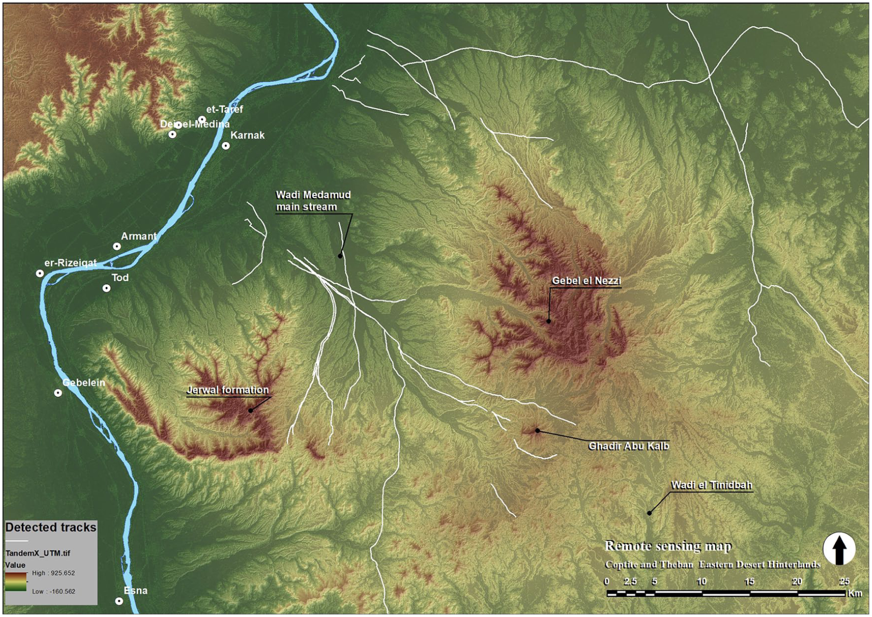
The designated research area can be identified as the Eastern Desert hinterland of the fourth and fifth nomes of Upper Egypt. This desert hinterland occupies the low desert that extends from the edges of the Nile Valley to the east and reaches the boundaries of the Red Sea Hills (fig.1).

The research area around Gebel el Nezzi (image: © CTEDH 2023).
The chosen area is a high hilly terrain (Gebel el Nezzi) associated with several wadi watershed systems that eventually flow into wadi mouths in the Nile Valley. This environment is characterised by its proximity to the Nile Valley, rather than the distant Red Sea Hills, creating a special environment that would host an extensive network of mobility and other human activities. The region comprises a number of wadis, which range from mainstream to tributary watersheds. These include Wadi el Qarn, Wadi Matula, and Wadi Zeidun, located to the north. The extensive wadi watersheds provide considerable access to the depths of the desert, extending towards the Red Sea Hills. They are distinguished by a gradual ascent and a general orientation towards the east and southeast. The geomorphology of these wadi systems, as ancient rivers, is represented by the extensive dendritic watersheds that fork out of each wadi. Notwithstanding the dearth of water in these basins, these watersheds, in conjunction with the mainstreams, engender a micro-riverine milieu. It bears noting that the entirety of these wadi systems is encompassed within Cretaceous limestone formations. South of these wadi systems is the Gebel el Nezzi formation. It forms a natural hilly terrain at the edge of the Nile Valley and, together with the associated wadis, dominates the landscape east of Thebes. This geological formation covers an area of 369,903 sq. km and consists of the Theban Group Serai Formation together with the Esna Formation in the lower parts. 1 It is located about 22 km east of Thebes and 17 km southeast of Medamud. The highest peak of the formation is about 800 m. However, it cannot be recognised as a single mountain. It is made up of several high peaks separated by several wadi systems that divide the terrain. All these wadis descend from Gebel el Nezzi to the northwest, such as Wadi Banat Berri, Wadi Kharit, Wadi el Bisat, Wadi el Temidat, and Wadi Hininat (fig. 1). Gebel el Nezzi is bordered to the south and southwest by Wadi Medamud, one of the largest wadi systems in the region. Together with Gebel el Nezzi, they form the Eastern Desert hinterland of the Theban nome. Like the other wadis, the watershed of Wadi Medamud extends to the west and northwest towards the Nile Valley. It forms a fairly wide wadi mouth that extends between the area of Medamud and the village of el Hebeil, south of Thebes.
Geomorphologically, the land cover of this vast area varies from one wadi basin to another, and from the wadi beds to the tops of the surrounding plateaus. In general, the land cover of the mainstream wadi beds consists of wadi deposits, while the associated wadi shoulders, plateaus, and smaller watersheds consist of Pliocene deposits: fluviatile siltstone, sandstone, and claystone (Issawiya Formation); closer to the wadi cliffs, lacustrine limestone (Durri Limestone) interbedded and capped by thick fanglomerates (Higaza Formation) 2 prevail. The first group can be identified as the Hamada surface. This surface is undulating or almost flat and is not easy to walk on because it is rough and full of gravel and large stones that need to be manoeuvred or cleared. The other main feature of the wadi surface is the presence of flash flood paths, which cut and deposit through the wadi beds every time there is a flash flood in the area. These paths are an extension of the Quaternary surface deposition process that created the surface of the wadis over thousands of years. The surface of the plateau, which has been eroded by water and wind over millennia, is characterised by flat or undulating surfaces that are interrupted only by the dissecting watershed network. The terrain is also classified as Hamada, characterised by gravel that has formed thin sheets of dark-coloured siliceous concretions and smaller limestone gravel. This type of Hamada land cover can be identified from satellite images as dark grey or dark brown spaces on the surface.
Wadi Medamud
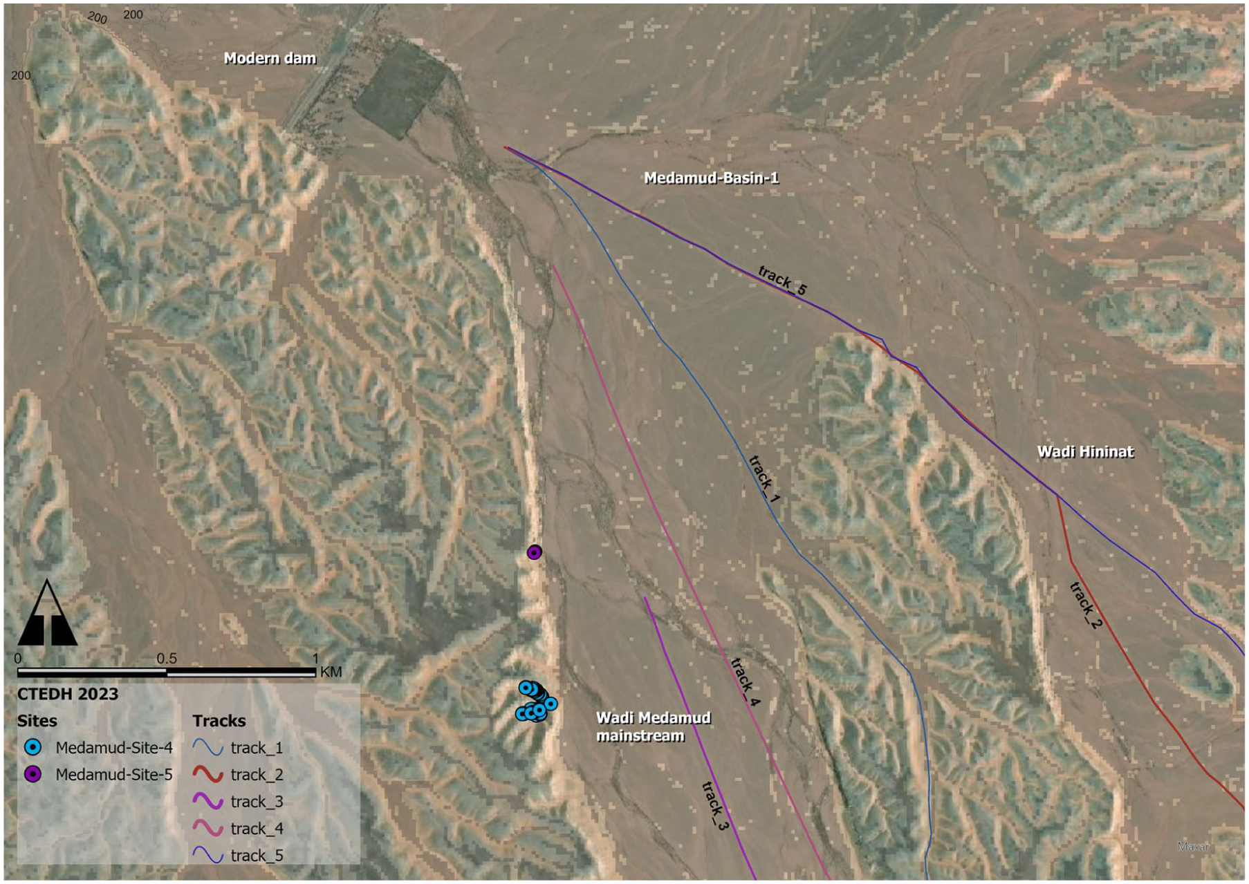
The Wadi Medamud watershed was the primary focus of the survey work conducted in 2023. The soil map of this wadi indicates that fluvial soils extend 30 km into the main wadi stream, which may suggest that this wadi was more vegetated during the Middle Holocene period. Indeed, the presence of vegetation in this wadi, particularly along the flash flood paths and water basins, is still discernible. The geomorphological characteristics of this wadi are consistent with those previously described. Wadi Medamud comprises two distinct basins. A wadi basin is an area where multiple watersheds, originating from higher elevations, converge to form a broad depression before uniting to form the main wadi stream. In the present era, three of these confluences were selected for the construction of dams, whose purpose was to impede the flow of flash flood water through the wadi and thereby prevent damage to surrounding areas. The cliffs, or shoulders, of Wadi Medamud are once more constituted of multiple stratigraphic sequences of lacustrine limestone. These cliffs are very fragile and eroded by wind and water constantly. The current surface of these wadi cliffs is not characterised by flat or smooth surfaces, with the exception of a few isolated instances.
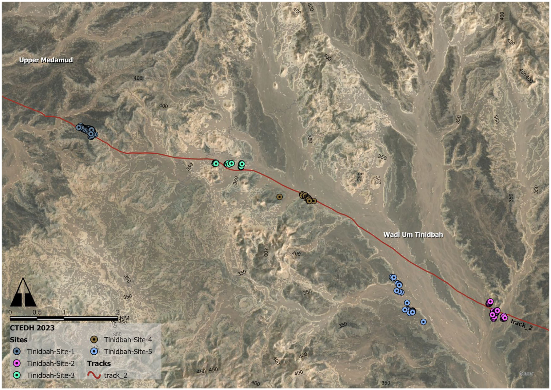
Wadi Medamud can be subdivided into three distinct sections (fig. 2). The Upper Medamud Watershed is situated to the south of Gebel el Nezzi and encircles Gebel Ghadir Abu Kalb (590 m). This section comprises a complex and extensive network of watersheds, which collectively converge with the Wadi Medamud mainstream at the first basin (1.7 km width). The upper reaches of the Medamud Watershed in the eastern and southern regions adjoin the Wadi Umm Tinidbah and Wadi Um Salam watersheds in certain locations. The watershed in this part is dendritic in pattern and has wadi shoulders with an average height of approximately 17 m. Evidence of significant water erosion can be observed at the wadi cliffs, where the lower portions of the cliffs exhibit deep gouges and cavities created by flash flood water streams. The slow erosion activity results in the occasional collapse of the wadi cliff faces. The effects of these natural collapses are evident throughout the wadi. The width of the Wadi Medamud mainstream in the upper part of the wadi decreases significantly, from an average of 400 m to 60 m, at the end of the wadi watersheds.

The main areas of Wadi Medamud (image: © CTEDH 2023).
Descending Wadi Medamud to the northwest, the Middle Medamud Watershed is characterised by a wider mainstream and more parallel watersheds joining it. Two of the large watersheds associated with this part are Wadi Hininat and Wadi Kharit. These two wadis are practically part of Wadi Medamud. Both wadis originate from Gebel el Nezzi itself, which makes their land cover slightly different from that of the Medamud mainstream. Dark brown and grey sands eroded from the Esna Shale Formations at Gebel el Nezzi are deposited in the flood channels of these two wadis. This middle part of the Medamud watershed ends at the second confluence where Wadi Kharit joins the Medamud mainstream (2.9 km wide). This area is considerably wider than any part of the Wadi Medamud mainstream and has lower wadi shoulders, situated at an elevation of approximately 5–8 m higher than the wadi bed. At the western side of this confluence, the wadi cliffs are formed by lacustrine oolitic limestone, which has smoother surfaces and a texture that resembles sandstone. The width of the Wadi Medamud mainstream in the middle part is between 600 and 800 m.
To the north, the Lower Medamud Watershed is distinguished by the presence of rather low and dispersed cliffs, which are markedly dissected by the surrounding watersheds and exhibit a relatively low elevation. The land cover in this area is characterised by the presence of aeolian sand, which accumulates over the Hamada surface and occasionally gives rise to the formation of sand dunes along the wadi shoulders. The width of the wadi mainstream in this part is approximately 2.2 km at the end of the wadi. The Nile Valley sedimentation meets the desert, creating a sharp edge at the cultivation. However, the terrain to the north and northwest is relatively flat and gently sloping. This area of the wadi is currently subject to significant disturbance as a result of human activity. Among the most notable of these activities is limestone gravel quarrying. The total length of the Wadi Medamud mainstream is approximately 45 km.
At the periphery of the Wadi Medamud system, in the transition to the Umm Tinidbah and Umm Khiyam wadi systems, there is a notable shift in the geomorphological characteristics. The ground is now predominantly covered with the Tarawan Formation (comprising white neritic chalk limestone and marl) and followed by the Dakhla Formation (comprising dark grey oscillating marine shale with calcareous intercalations). 3 The landscape is punctuated by isolated knolls or inselbergs, which are characterised by highly porous slopes and a flat, dark limestone summit. Similar formations have been observed in the Western Desert. 4
Flora and Fauna
A minimum of flora has been preserved behind the various dams, as well as in some locations within the deepened wadi channels. The flora is primarily composed of small shrubs belonging to the species Zilla spinosa and Tamarix aphylla, with scattered acacias, including acacia tortilis and acacia ehrenbergiana, also present. With regard to wildlife, evidence of the presence of smaller lizards and birds of prey, as well as smaller birds, was observed. Additionally, free-roaming domesticated camels, foxes, and migrating storks were noted. Insects, including dragonflies, were also identified.
Remote Sensing: Approach and Methodology
Prior to the actual fieldwork, a remote sensing analysis was conducted with the objective of identifying potential ancient routes or tracks that could serve as a foundation for the subsequent survey. For this purpose, different satellite images have been used: Google Earth images, World Imagery provided by Esri, and Landsat Data.
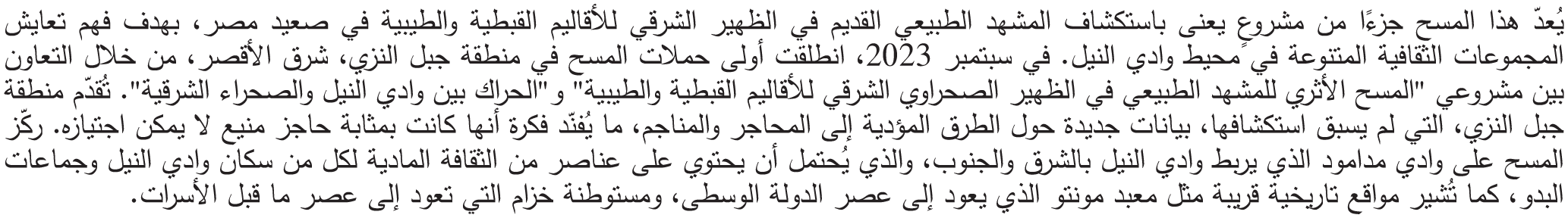
Extensive tracks have been found which begin mainly in the lower Medamud area (fig. 3). The tracks branch off from the Nile Valley in the area between the village of el Hebeil, southeast of Thebes, and the town of Medamud. Several tracks have disappeared due to flash floods or modern activity in the region. However, it was possible to find about five tracks that can be traced in various branches in Wadi Medamud, in Wadi Hininat, and along the upper plateaus surrounding these wadis. The other main feature discovered was the presence of a number of structure-like clusters in several locations in the area of Medamud and Gebel el Nezzi. The nature of these features was not clear at the time. However, it was possible to identify some camps with round huts. On the other hand, stone lines and geometric stone features were seen forming some concentrations.
Track 1, as seen in satellite images (images: © Google Earth).
Remote sensing approaches were utilised to identify potential routes through a specified area by creating multiple least-cost paths (LCPs) via GIS. Digital elevation models (DEMs) such as ASTGTM, SRTM-1, and TanDEM-X 12m were used, with starting points in the Nile Valley near the villages of Medamud and Khozam, known for archaeological evidence spanning the Predynastic to Roman periods. 5 Initially, Gebel el Nezzi was not considered a region with economic resources, leading researchers to hypothesise that routes extended further east. A potential route was identified between Medamud and the wadis of Batur and Miyah to the south, traversing east–west. Bir Umm Tinidbah, mentioned in the map published by Hans Alexander Winkler (1900–1945) 6 and recently investigated for the first time and studied by John Darnell, Yale University 7 , was identified as a possible destination due to its accessibility via Wadi Medamud and Wadi Umm Tinidbah. This well probably existed in earlier times and could have served as a stopover along a route through Gebel el Nezzi, connecting the Nile Valley, Wadi Barramiya, and mining areas near the Red Sea Mountains. Destinations east and southeast, particularly sandstone areas with mines, rock art, and inscriptions, were prioritised for further exploration.
Remote sensing applications facilitated the identification of survey locations, and satellite images helped verify field structures and identify additional features (fig. 4). Fieldwork began by verifying the remote sensing findings, focusing primarily on tracks, which were readily identifiable. Two categories of tracks were observed: single tracks and ‘bundles’ of smaller tracks, probably created by caravans rather than modern vehicles. Potential tracks were approached by car and systematically investigated. Tracks were documented by walking or driving along them, stopping at intervals to record positions using a Trimble DA-2 GNSS, as well as describing and photographing them. Surrounding features, such as ceramics and cairns (Alamat), were also documented, photographed, measured, and sketched. Satellite-identified features close to the tracks were explored and documented in the same manner. The collected spatial data and descriptions were incorporated into a GIS geo-database to refine the analyses.
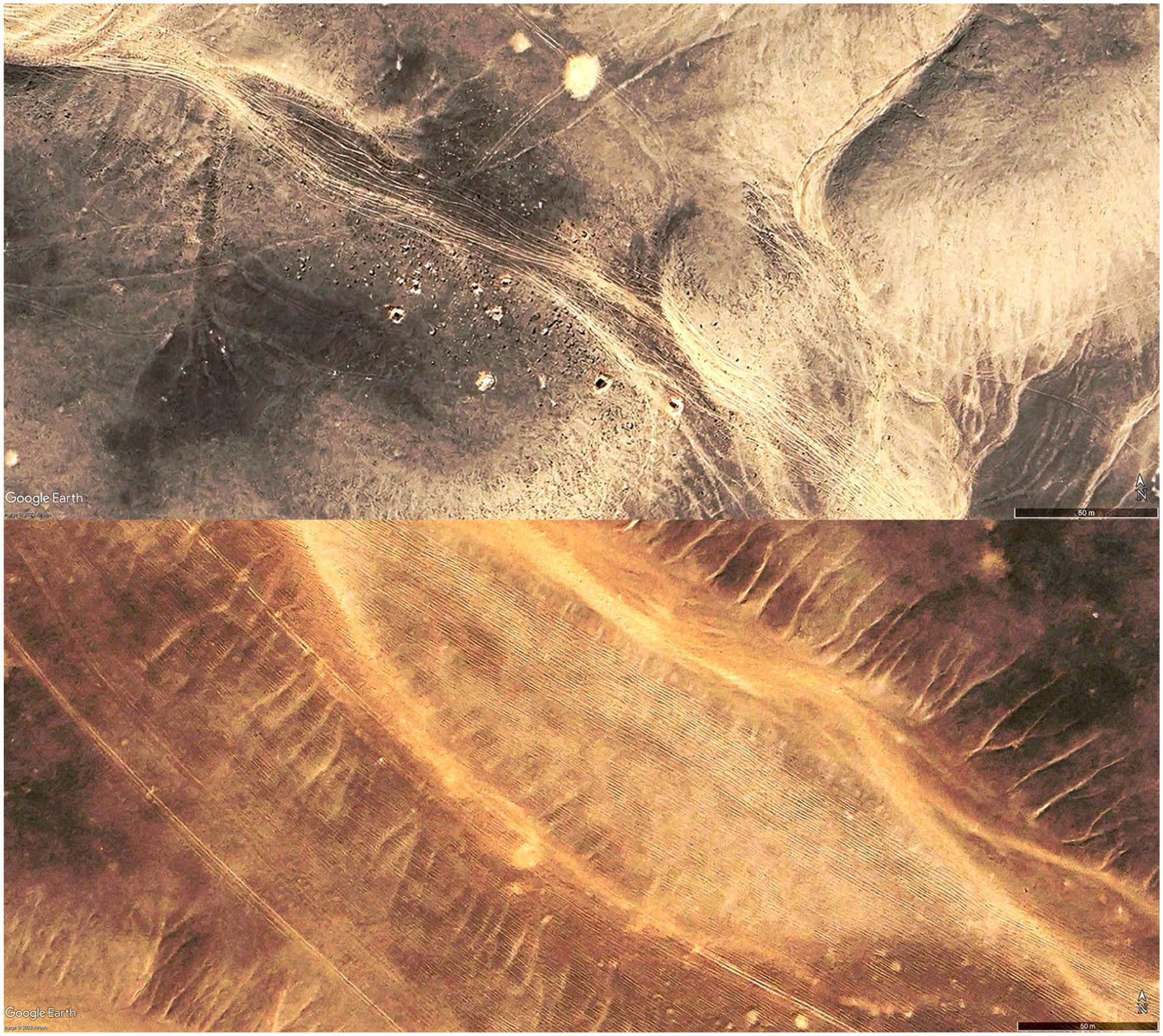
Bundle tracks in the Wadi Medamud area with up to 22 lanes (image: © CTEDH 2023).
The Wadi Medamud has been obstructed in three sections by dams constructed to prevent flash flood damage to nearby villages. Limestone quarrying east of the Luxor–Aswan Desert Road has also caused significant landscape destruction. As a result, surveys began in the upper reaches of the wadi, near its source, approximately 40 km from its mouth. The first bundle track identified through remote sensing (Track 1) was verified in this area.
The survey expanded to the middle and upper reaches of Wadi Medamud, as well as its adjoining tributaries. This included the System of Wadi Hininat to the northeast, several of which branch off from Wadi Medamud, as well as the wadi systems of Umm Khiyam to the south and Umm Salamah and Umm Tinidbah to the southeast. Archaeological finds and features were recorded along these routes, focusing on evidence of ancient activities such as mining, hunting, and grazing.
The systematic survey approach enabled researchers to document material culture, such as ceramics and stone cairns, and map them in relation to caravan tracks. Significant features identified in satellite images were revisited during fieldwork, provided they were within close proximity to the documented tracks. The integration of remote sensing data with field observations proved essential in refining the understanding of ancient routes and their use, particularly as they related to economic activities and regional connectivity.
Tracks
One of the primary material cultures focused on during the survey campaign was that of tracks. The tracks are the result of repeated use of a route by travelling groups. The numerous burden animals in their march dislodge stones and gravel from the Hamada surface, creating a track with accumulated gravel on both sides. The ruts or grooves thus became more readily traversable by subsequent caravans. With repeated use, the ruts become established as tracks or routes. Subsequently, due to the accumulation of aeolian sand or fluvial sedimentation within the ruts, the landscape becomes increasingly rigid, thereby preserving the tracks on the surface. 8 One can envisage a caravan comprising hundreds of animals traversing the landscape in large groups, resulting in the formation of bundles of ruts (bundle tracks) behind them. Similar tracks are known from several other landscapes in Egypt and are well documented. Similar tracks were found and interpreted by other scholars all over the desert landscape. One prominent example is at the Darb el Tawil route. 9
The result, at least from the evidence currently available, is tracks that can be as wide as 26 lanes (22 m) in some segments (fig. 3). The abovementioned tracks are discernible from satellite images in areas characterised by the presence of Hamada surfaces that remain uninterrupted by modern activity. Typically, these tracks manifest as numerous broad parallel lines extending in a single direction.
The preliminary remote sensing survey identified a number of tracks within the Wadi Medamud watershed. In several instances, the tracks extended beyond the boundaries of the aforementioned watershed, continuing to the east and southeast. The majority of the detected tracks visible in the satellite images originate from the eastern periphery of Thebes. However, the disturbed condition of the landscape at the Lower Medamud Watershed precluded a systematic investigation of the tracks before the start of the ground survey at Medamud Basin 1 (Middle Medamud) (fig. 2). The ground survey conducted during the 2023 campaign was successful in identifying five principal long-distance tracks traversing the Wadi Medamud watershed and the adjacent plateaus. Additionally, a sixth track was partially identified (fig. 5).
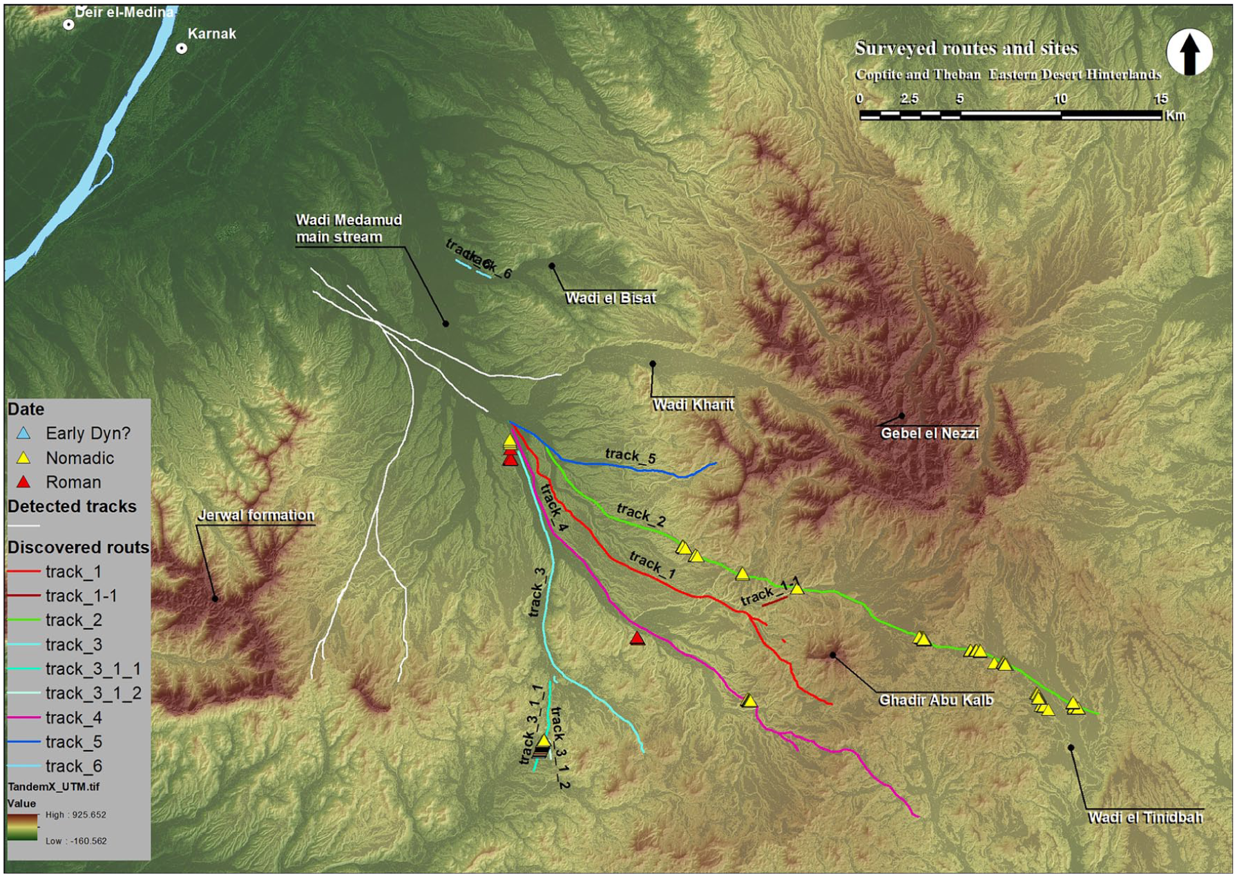
Map of the detected tracks and sites (image: © CTEDH 2023).
The tracks comprise a series of parallel ruts, with an average width of 40 cm. The ruts are arranged in rows of two to over 20, with the rows positioned in close proximity to one another. The number of ruts is typically reduced on slopes or ascents, with some converging and others appearing to fan out. In general, irregularities in the parallelism of the ruts are evident at both ascending and descending points. Contrary to the assumption that caravan routes exclusively traverse wadi beds, the observed behaviour of the discovered routes evidences a tendency to traverse not only the wadi bed but also the adjacent plateau tops. In some cases, the route would go through the main wadi bed following its watershed, in the case of Medamud to the southeast. However, it is notable that in other instances, the routes utilise the wadi bed to a certain extent, then ascend to the plateau or the wadi shoulders to benefit from the flatness of the smooth Hamada surface, as evidenced by Tracks 1 and 2. This behaviour can be attributed to the fact that certain segments of Wadi Medamud are characterised by surfaces that are nearly impassable, due to the presence of large boulders of stone that create the Hamada surfaces, or due to the deeper erosions caused by flash floods that have cut through the landscape, thereby limiting the efficiency and speed of movement in these areas. In other instances, it is possible to discern the presence of parallel tracks, one following the course of the wadi bed and another traversing the plateau surface. This is exemplified by Tracks 1 and 4.
The lower part of Wadi Medamud was difficult to survey due to the presence of modern tracks, remnants of recent flash floods, and construction materials and artificial heaps of sand. Consequently, the survey was conducted with greater efficiency at the Middle and Upper Medamud Watershed. Similarly, apart from Track 6, all other tracks were only followed in greater detail behind the second dam. Track 6 is a special case because it leads relatively early on into a minor wadi, Wadi el Bisat, to the east, and thereby deeper into the actual Gebel el Nezzi mountains. This track was not pursued in the current campaign, but it is intended to be included in future campaigns. The five tracks that were identified directly behind the second dam exhibited markedly disparate orientations. While the initial stages of each track are discernible in the satellite imagery, it was not feasible to gain access to or definitively identify all the tracks before the second modern dam where the wadi begins to bifurcate into three different directions (Medamud Basin 1). As a consequence of the modifications to the landscape during the construction of the dam and the repeated flooding, the floor of the wadi has been significantly damaged, making it challenging to discern the remnants of the tracks in certain locations. This makes it difficult to determine the point of origin of Tracks 3 and 4 in this region. The archaeological remains discovered in the vicinity of the five documented tracks exhibit notable differences from one another. Each of these remains is discussed individually and in relation to the surrounding tracks.
Track 1
This track was identified via satellite imagery as a wide bundle of ruts or tracks on the undulating plateau forming the eastern shoulder of Wadi Medamud. The track begins in the bed of Wadi Medamud and runs southeast, ascending the plateau after passing through Medamud Basin 1. The ascent is gradual via a smaller wadi that leads through a narrow area before reaching the wide, flat plateau. The route continues toward Ghadir Abu Kalb, a prominent mountain. Before reaching the mountain, the track splits: Track 1 arcs southward around the mountain, while Track 1_1 terminates at its base. Another branch, Track 1_2, deviates northeast and converges with Track 2.
Behind Ghadir Abu Kalb, Track 1 becomes indistinct due to significant erosion of the wadi bed. However, it is hypothesised that it may have been connected to Wadi Umm Salamah. Notably, the track does not stay within the wadi bed but follows a plateau near the wadi beds of Medamud and el Hininat. Archaeological evidence along the track includes Alamat (stone cairns), lithic debris, and a modern campsite. Approximately 5 km before reaching Ghadir Abu Kalb, the track descends into the wadi bed of an eastern branch of Wadi Medamud, following it briefly before turning into a smaller wadi running south toward the hill. Here, the track splits at a small hill, offering a panoramic view of the surrounding terrain. A small stone circle, probably a hearth, is visible at the hilltop. Track 1 continues south along elevated plateaus, while Track 1_1 follows the wadi course, though only a few ruts remain due to erosion. This wadi’s narrow gully leads to the plateau of Ghadir Abu Kalb, where Ghadir Abu Kalb Site 1 is located.
Track 1 proceeds along the plateau, descending into a tributary of Wadi Medamud. During this elevated section, several archaeological finds were made, including pottery at three distinct points. One notable find is a marl clay storage jar that had been crushed on the road; reconstruction of the fragments showed that we have almost the complete vessel. The central section of the track, which diverges from the wadi to traverse the plateaus, also revealed Alamat and lithic remnants, mostly dark flakes with a light, cream-coloured cortex. The route eventually crosses smaller wadis of Wadi Medamud and continues southeast until it becomes indiscernible.
Track 1_2, which diverges northeast, yielded ceramic finds along its path. A round stone pile was discovered about 40 m from the main track along the edge of a minor wadi, where pottery evidence was also found. Near the convergence of Tracks 1_2 and 2, a single track was identified along a side wadi to the south, though this potential route was not investigated further.
The track can be divided into three main segments. The first segment traverses the relatively flat bed of Wadi Medamud, with a smooth surface aiding orientation. The second segment begins as the track ascends the plateau or wadi shoulder. An Alama marks the ascent point, and the track follows the wadi topography until reaching the plateau. At the plateau’s top, the track reaches its widest point, averaging 60–70 m in width and peaking at 152 m. It then narrows to 27 m before descending into Wadi Medamud again. The descent point is narrow, measuring 12 m. The third segment is narrower and involves multiple ascents and descents across wadis.
Throughout these segments, the track maintains a consistent inclination between 0 and 4 degrees, except at descent and ascent points, where the slope reaches 9 degrees (fig. 6). According to the concept of directional intentionality 10 it can be inferred that travellers used Ghadir Abu Kalb as a prominent landmark to orient themselves southeastward, with Gebel el Nezzi visible to their left (north). This directional reference was probably maintained through the second segment.
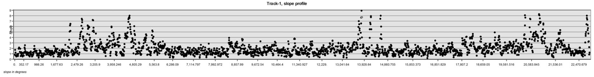
Slope profile of Track 1 along the documented path (image: © CTEDH 2023).
In the third segment, several movement options emerged around the Ghadir Abu Kalb escarpment. One route proceeded southeast around the mountain, while another track moved northeast to join Track 2. Movement in this segment involved navigating multiple wadi beds while maintaining orientation. Unfortunately, the subsequent path of the route after descending into Wadi Umm Salamah remains unclear due to the erosion and lack of discernible features.
Track 2
Track 2 has been explored for the longest period of time, with large sections examined on foot. It begins in the northeastern branch of Wadi Medamud, heading southeast through the wadis and plateaus of Wadi el Hininat, which run parallel to Wadi Medamud. The track passes between Gebel el Nezzi and Ghadir Abu Kalb before reaching Wadi Umm Tinidbah, situated at the eastern upper watershed of the Medamud wadi system. As this location marks the limit of the concession area, the track was not investigated further, though it appears to continue southeast.
Track 2 has yielded the greatest number of identified sites and discoveries of all tracks investigated in the region. At the start, after ascending from the Wadi el Hininat bed to the plateau, a large concentration of pottery fragments was identified in situ, some embedded in tafla sedimentation. These fragments include remains of large storage jars and other pottery. About 3 km along the track, at a point where it descends from the plateau into a small side wadi, Hininat Site 4 is located on the valley’s edge. At this descent point, further concentrations of pottery and lithic artefacts were discovered.
The track continues across a plateau, passing isolated stone circles, stone lines, and round stone piles near lithic materials. About 3.5 km from the start, the track splits. One branch descends an embankment into a minor tributary running northeast, where deep channels from the prior activity are evident, though ruts become indistinct due to partial washout. The primary route follows the plateau, passing near Hininat Site 1, which is situated above a bend in the wadi.
Five hundred metres farther along, Hininat Site 2 is located. Around this point, the track crosses a small arm of Wadi el Hininat and proceeds across the plateau. Along this section, it passes two locations with a total of four stone lines, a rectangular stone structure, and another pottery site before descending again into a side wadi of Wadi Medamud. Upon crossing the wadi, a series of stone piles and pottery concentrations lead to Hininat Site 3. Over the next 3 km, sites are densely clustered, including eleven stone lines, one pottery and one lithic concentration, a rectangular stone structure, and a round stone structure. These culminate at Medamud Site 3.
After Medamud Site 3, the track descends from the plateau into the wider bed of Wadi Medamud, just over 100 m from the site. Along the first 200 m of this descent, pottery concentrations, including early Roman amphorae, and lithic remains are evident. Another round stone pile lies north of the track. The track then follows the southern branch of the wadi for approximately 4 km before ascending once more to the plateau. At this stage, it passes three additional stone circles situated within the wadi bed.
The transition between the Wadi Medamud and Wadi Umm Tinidbah systems begins shortly afterwards. Tinidbah Site 1 is located 2 km after ascending to the plateau. Behind this site, the terrain slopes downward. Two stone lines with a stone structure and four additional stone structures are located approximately 800 m apart, along with two round stone piles. At this point, the Hamada desert surface transitions to a finer, fragmented landscape with occasional knolls (inselbergs). The track becomes indistinct due to the soft, sandy surface, leaving only a few ruts intact.
Tinidbah Site 3 lies 600 m further along, followed by Tinidbah Site 4, another 1 km away. Beyond this, after 1.5 km, the track disappears entirely due to soft soil. Tinidbah Site 5 is located 650 m west of the wadi, while Tinidbah Site 2 is approximately 1.5 km to the east. East of these sites, the track reappears on a small plateau and continues eastward, leading to three stone lines surrounded by Alamat. Here, the track would descend into another tributary branch, but the survey was interrupted, with further investigation planned for the next campaign.
As with Track 1, the likely destination of Track 2 lies southeast. The parallel orientation of the two tracks, along with the connecting branch (Track 1_1), suggests possible chronological or spatial links. Both tracks contain ceramic fragments that can be roughly dated to the Roman Period. Track 2 traverses moderate slopes during its ascent and descent, with gradients ranging from 5 to 15 degrees. The numerous sites along its route may reflect an intentional alignment influenced by these locations. However, no definitive chronological connections have been established between the track and the adjacent sites.
The track passes all identified sites without causing any disturbances, except at Tinidbah Site 1, where the descent from the plateau to the wadi bed intersects directly with the site. The segmentation of Track 2 is comparable to that of Track 1. It begins at the Wadi Medamud bed, ascends over the Wadi el Hininat plateau in the second segment, and descends into various wadi beds and shoulders in the third segment. In the fourth segment, it leaves the Wadi Medamud watershed and enters the Wadi Umm Tinidbah watershed.
Track 3
Track 3 runs in parallel with Track 4, with a distance of 200–300 m between them. Both tracks follow the wadi bed for the majority of their respective lengths. Due to the time pressure at the end of the season, the track was mainly followed by car, although comprehensive measurements and detailed notes on significant locations were taken.
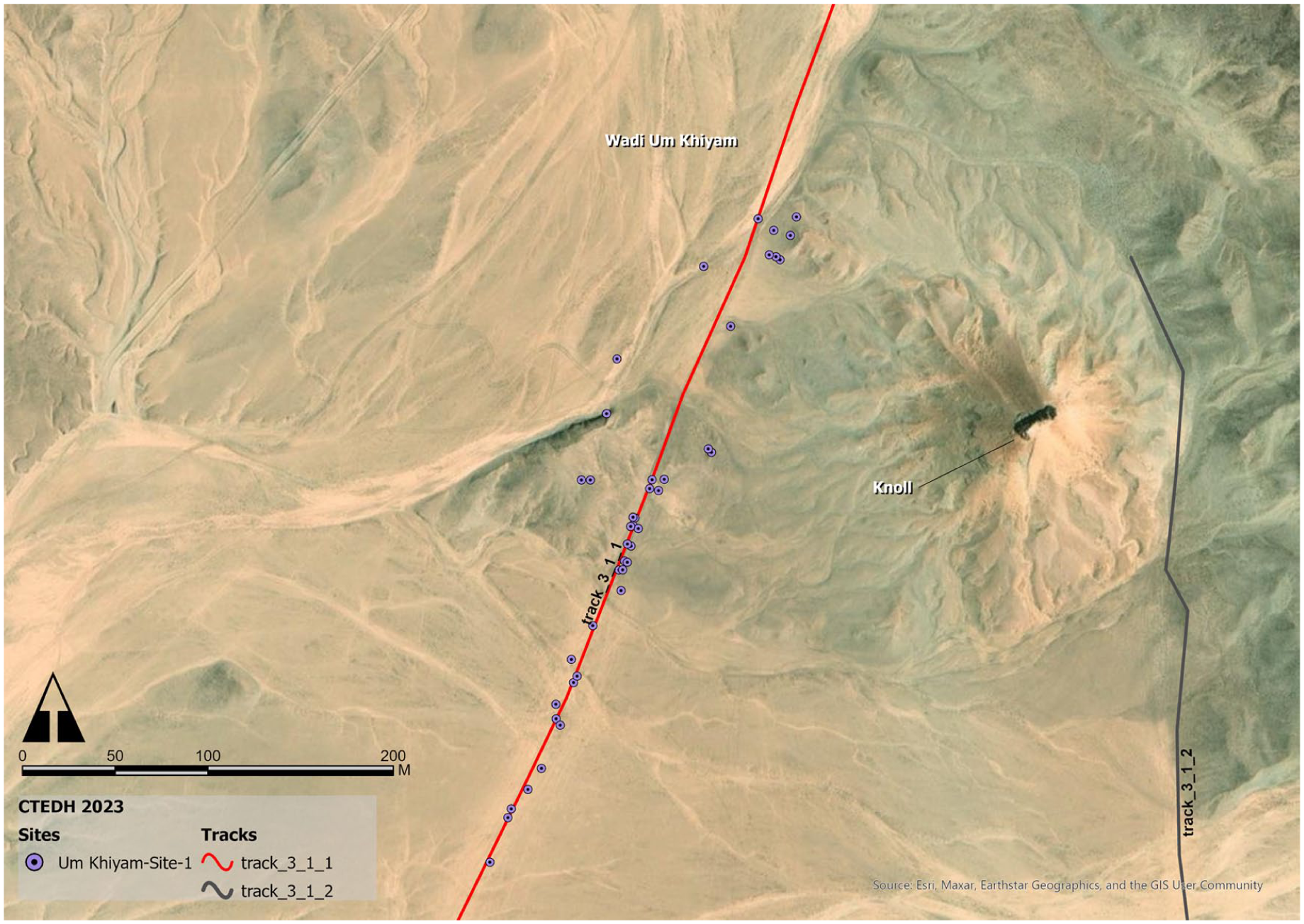
In contrast to the other tracks, Track 3 is oriented in a markedly southerly direction. The wadi runs for approximately 7 km through the centre of Wadi Medamud, after Medamud Basin 1, and then turns into one of the smaller branches of the wadi, continuing for another 4 km. At this point, the track branches off; Track 3 continues in a southeasterly direction, following a small side wadi. The other branch extends further south (Track 3_1) until it reaches the wadi system of Wadi Umm Khiyam. At this point, an additional branch (Track 3_1_1) diverges from the main route. At this point, the Hamada surface transitions to the finer surface of the Dakhla Formation, which is characterised by the presence of knoll features (inselbergs). The aforementioned tracks ultimately terminate at the boundaries of the concession area, rendering further investigation impractical. Nevertheless, it is possible to trace Track 3_1 on satellite images as far as Wadi ash Shuki in the south, in the vicinity of Esna.
At a distance of approximately 400 m from the documented point of origin of the track, a minor tributary wadi diverges to the west. Medamud Site 4 is situated at the point where this wadi begins, having been destroyed by modern quarrying activities and the construction of a road. A number of pottery accumulations were observed along the main path, the precise nature of which requires further study. The rest of the track had lacked material culture so far. This situation changed at the junction with Track 3_1. This is where Umm Khiyam Site 1 was discovered, and in the vicinity of this site, as well as at the junction of Track 3_1_1, a cluster of Alamat was also found. The geomorphology of the area contains evidence of iron ore deposits that can be observed directly on the surface.
Track 4
Track 4 was primarily surveyed by car. It runs in a southeastern direction along the upper edge of the main Wadi Medamud. The initial segment of the track runs along the Wadi Medamud mainstream. The track in this segment follows a path at the extreme eastern end of the wadi bed. The track proceeds in a southeasterly direction along the course of the wadi, passing through Medamud Basin 2. Next to this part, in a side wadi to the south of the basin and to the west of the main Wadi Medamud, is Medamud Site 1. Behind this, the track continues along the wadi bed until it reaches a smaller wadi, where it ascends the plateau briefly, passing by Medamud Site 2, before descending into the wadi bed of the Upper Medamud’s smaller tributaries. Following this, segment two of the track deviates from the wadi bed, continuing in a more or less straight path towards the southeast. At the end of the catchment area of Wadi Medamud, the track splits. While the original Track 4 vanishes in the softer soil and cannot be traced any further, Track 4_1 could be followed further southeast, where it descends into the Wadi Umm Salamah watershed system in a third segment. This Wadi runs roughly from northwest to southeast and flows into the lower part of Wadi Umm Tinidbah, which has a north–south course. However, this part of the track lies outside the concession area and could therefore not be followed up; the satellite images revealed that the track was continuing its southerly trajectory towards the Wadi Umm Salamah watershed in a parallel path to the main track. At the beginning of Track 4 in particular, several individual pottery sherds were identified in or between individual ruts. It can be observed that the majority of the pottery sherds were of a reddish, coarse ceramic; a more precise dating is still pending.
Track 5
To date, Track 5 is the only one that does not lead to a distant destination outside the Theban desert hinterlands. Although its visible traces appear to originate at the Medamud Basin 1 area, akin to all other documented tracks, its eastern orientation leads it up the hill through the Wadi Hininat wadis into a semi-circular high steep face of Gebel el Hininat. The track was primarily explored by vehicle, with the survey conducted on foot only at its farthest point.
The archaeological remains that could be identified along Track 5 were limited in number. The track terminated at the base of an approximately 300 m-high limestone rock face. An initial inspection of the immediate vicinity revealed no evidence of stone lines or geometrically shaped stone features, pottery, or similar items. The reason for the termination of the track at this point remains uncertain. Further investigation of the site is required. A single pottery fragment was found at the end of the track. However, this was located in the wadi channel, which suggests the possibility that it was not an in situ find.
Archaeological Sites
A number of sites were identified in the vicinity of the tracks, with a few instances also observed in the adjacent wadis. A site is defined as a conglomerate of various types of features and finds. To date, the sites have only been documented in a cursory manner. This has entailed measuring the features and finds, providing descriptions, and taking photographs. The stone structures were classified into distinct categories based on their shape: stone line, rectangular stone features, irregular stone features, round stone pile, circular stone features, and crescent stone features.
Ghadir Abu Kalb Site 1
In the vicinity of the summit of Ghadir Abu Kalb, a roughly round stone feature (fig. 17) is discernible. The structure is primarily composed of weathered black limestone blocks arranged in a loose configuration. In some instances, multiple rows are positioned near one another, which may be indicative of a collapse. The presence of multiple rows of smaller stones within the feature suggests the potential for subdivisions. The feature is circumscribed by a radius of approximately 100 m, within which lithic flakes and remains are present. These include core pieces and blades, some of which exhibit retouches.
Hininat Site 1
A total of 29 stone lines are distributed across an area of 320 m x 60 m (fig. 7). These comprise larger stones sourced from the surrounding area. The stone lines run from the northeast to the southwest, and in their southwestern area they are partially cut by the traces of the tracks. Two rectangular stone features are located in the northwest, adjacent to the stone lines. Another such feature is situated in the southeast. Up to eighteen stone circles are situated between, and to the south and southeast of the aforementioned stone lines.
Hininat Site 1: several stone lines with stone circles in between (image: © CTEDH 2023).
The stone circles exhibit a range of sizes, with some featuring additional stones within the circle. This suggests the possibility of subdivision or the presence of installations within these structures. In one instance, two circles are observed to be connected. Two circles located to the south are situated in the vicinity of the track’s ruts and have been partially destroyed by them. The site has thus far been documented using digital photogrammetry; however, further processing is still pending. Approximately 100 m to the southeast of the site, along the track, there is another elongated, round stone structure. The structure is approximately 4 m in length and comprises larger stones from the surrounding area. A collection of ceramic sherds was discovered in the vicinity of the aforementioned structure along the track. The precise chronology of these remains is yet to be determined.
Hininat Site 2
This site comprises 42 stone lines situated at an elevated point on the valley edge. At its upper end, a line of protruding rock forms a kind of natural barrier. The stone lines run from northeast to southwest and are intersected by the tracks in their lower reaches. The discovery of ceramics in the southeastern part of the site awaits further analysis to determine their age.
Hininat Site 3
A substantial, elongated rectangular feature, oriented northeast to southwest, is bisected by another line at its midpoint. The area also contains isolated deposits of flint. At its southwestern extremity, the feature is traversed by the traces of Track 2. There are isolated, larger stones in the direction of the feature, oriented in a manner that suggests they were destroyed by the track’s lanes. The stones used are likely to have originated from the surrounding area. They are black limestone chunks that lie loosely next to each other in one layer. Pottery and stone tools were discovered on the track approximately 50 m away from the rectangular structure. To the north, there are two round stone piles. The central portion of one of them appears to have been recently excavated. The structures consist of medium-sized stones from the surrounding area, which cover a round-oval area.
Hininat Site 4
The site comprises two stone circles or, alternatively, the remains of round stone piles that have been disturbed. It is no longer possible to make an exact assignment due to an illegal excavation in their midst (fig. 8). Both features are situated at an elevated location on a plateau at the edge of the valley, with a view of the wadi. The stone circles are situated at a distance of approximately 50 m from one another. The presence of human bone remains in one case suggests that these may be graves. Additionally, ceramic and lithic artefacts have been recovered. One of the ceramic sherds exhibits characteristics consistent with C-ware, which would permit a date to be assigned to the Naqada I period. However, further analysis is required to confirm this. Other potsherds display a dark red polished surface, but a detailed assessment is still pending.
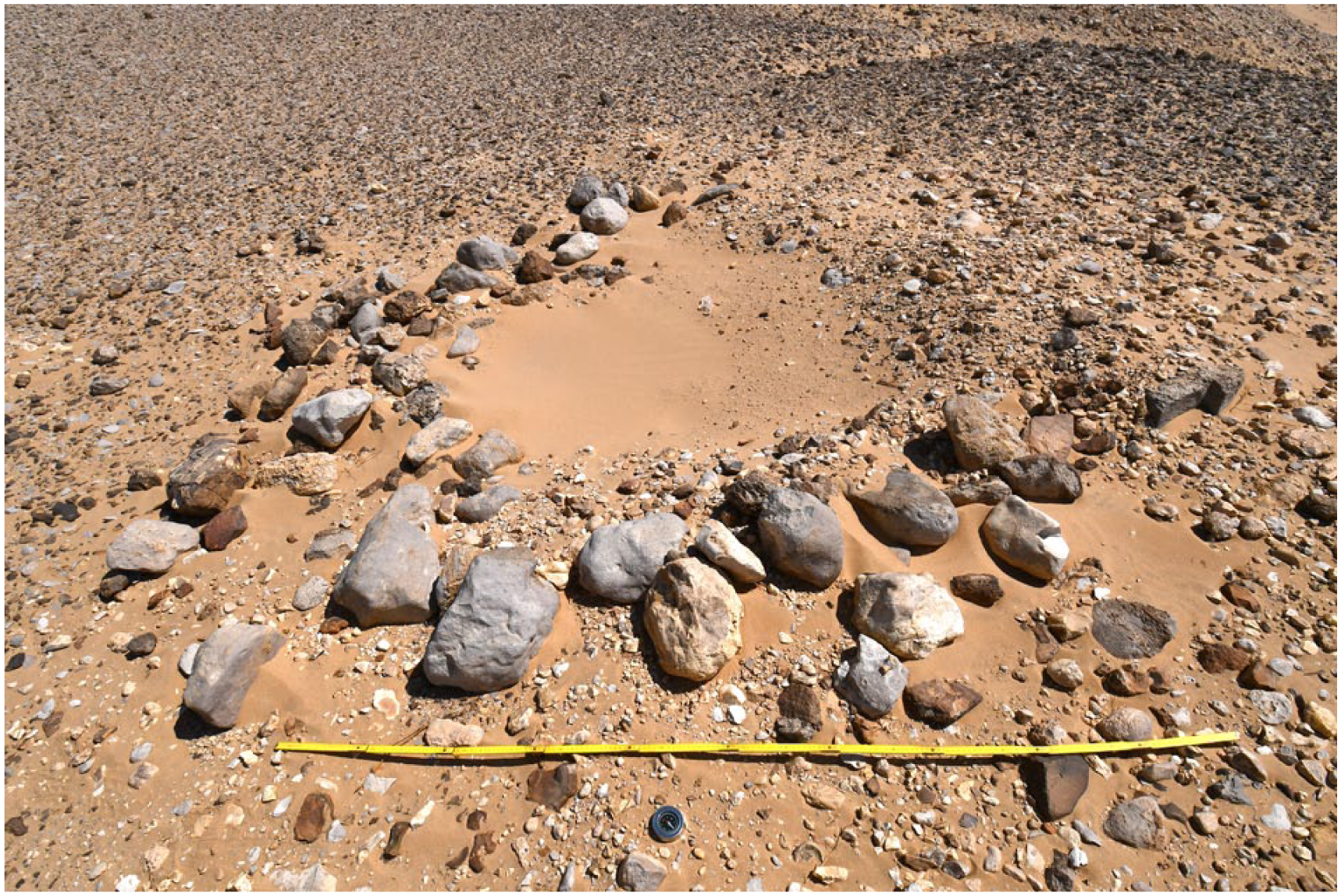
Hininat Site 4: one of the destroyed stone circles, possibly a grave (photo: © CTEDH 2023).
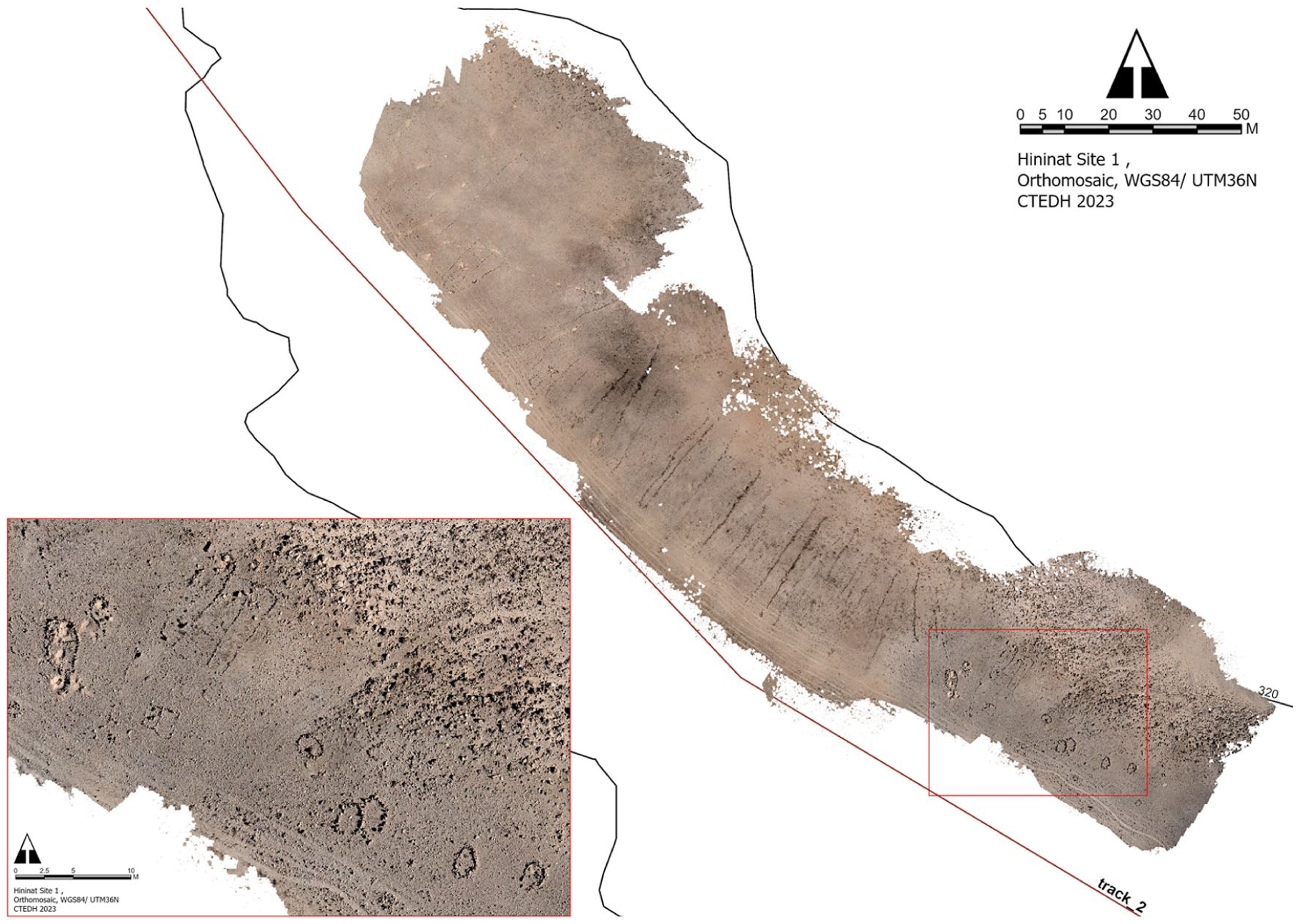
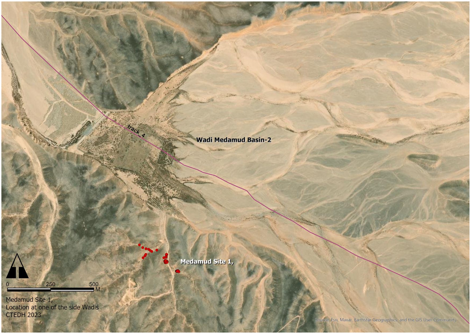
Medamud Site 1
Approximately 500 m behind the third dam, Medamud Basin 2, in a small side wadi on the south and west cliffs of Wadi Medamud, there is a considerable number of stone structures (fig. 9). Seven of these structures are situated on the eastern branch of the wadi and display evidence of damage caused by the construction of a modern road. It is uncertain whether additional structures existed beneath the modern road. Two additional U-shaped structures are present in another, smaller wadi that runs eastward. In connection with these, several ceramic finds can be dated to the Roman Period. The western branch of the wadi has a greater number of structures, which are distributed along the narrow wadi bed. The shapes exhibit a variety of forms, including circular and rectangular, and the entrances are not oriented in a single direction. In close proximity to one of the structures (shelters), a small accumulation of calcite (Egyptian alabaster) was found in situ. Similar material was also discovered in a dispersed manner across the site. It is reasonable to hypothesise that the activities within this camp were likely associated with the quarrying of this material. It is probable that the material was worked to a certain extent before being transported back to the Nile Valley. Following the side of the wadi, an exhausted modern quarry was discovered. This collection of stone features (shelters), comparable to Medamud Site 4, can also be assumed to be a camp associated with stone quarrying.
Medamud Site 1: several stone structures are a probable camp for mining calcite (image: © CTEDH 2023).
Medamud Site 2 (fig. 10)
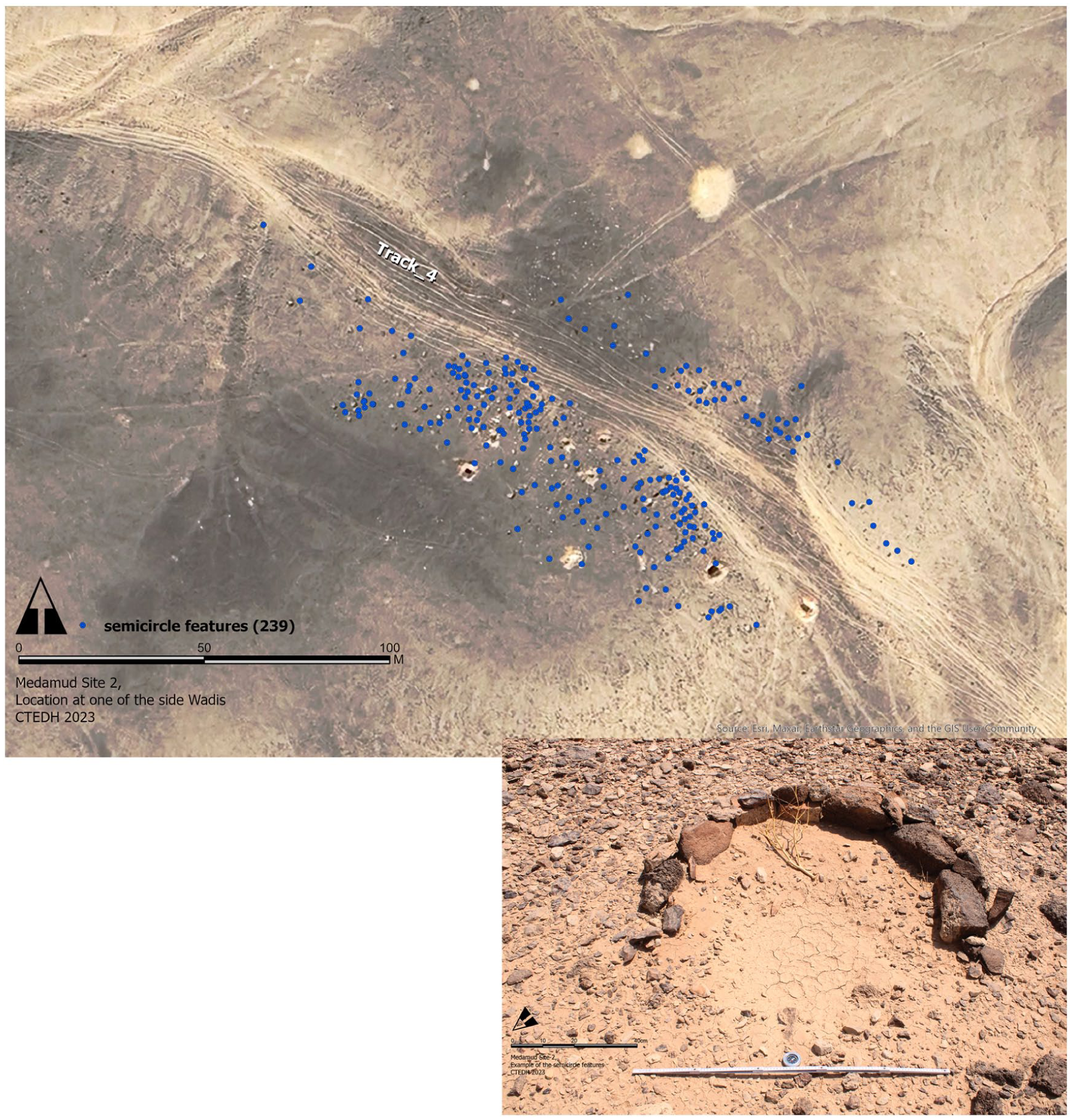
Medamud Site 2 (image: © CTEDH 2023).
This area is approximately 300 m long by 70 m wide and contains 239 semi-circular structures, or crescents, distributed throughout it. It seems probable that the stone features have been disturbed by Track 4, which has divided the site into two. Some of the stone features remain discernible between the tracks’ ruts. While some exhibit a complete circularity, others display angular characteristics. A small number of these crescents are situated at a distance of between 100 and 150 m from the majority of the other features, in a northerly direction. All of the stone features are positioned with their open side facing northwest and range in size from 50 to 150 cm in diameter. Some of the larger semi-circular or full circular features appear to have been excavated, with the result that their centres exhibit deep holes, some of which also branch off to one side. Further investigation is required to ascertain whether these are exposed, original parts of the features or whether these pits were created as a result of illegal excavation.
Medamud Site 3
The site comprises three stone lines that extend from an elevated position on the edge of the wadi to Track 2 in the wadi bed. The outer stone lines are connected at their upper end to two stone circles. One of the structures is recessed in the middle and exhibits evidence of sand deposits. It is probable that the central portion was excavated. The second stone line is somewhat more oval in shape, and the row of stones is not entirely continuous. In the lower section of the stone lines, there appears to be evidence of overlap with the tracks.
Medamud Site 4
In a small side wadi on the western side of Wadi Medamud (fig. 14), located just beyond the second modern dam at Medamud Basin 1, there are remains of fifteen roughly rectangular stone structures and one semi-circular structure. These structures have been preserved in some layers. The structures are situated in close proximity to the cliffs of the small drainage channels that have formed on this side of the wadi. Based on the structure of the stone buildings and because the structures are built in the same way as the ones in Medamud Site 1, with drystone and no mortar, it can be assumed that they could also be temporary quarry camps. Several potsherds were found at the beginning of the side wadi, which can be roughly identified as Roman amphoras’ body sherds. A more detailed archaeological investigation is still pending.
Medamud Site 5
The site is a relatively simple overhang situated at an elevated position on the western side of Wadi Medamud. The stone in this area exhibits a greater degree of consolidation than that observed in the surrounding limestone. At this point, calcite veins emerge. The remains of Roman ceramics were discovered in the narrow area in front of the overhang and on the sandy slope below. It seems reasonable to posit a connection between Medamud Sites 4 and 5, given the presence of calcite veins associated with Roman material culture at a distance of no more than 420 m from a Roman camp (fig. 11).
Medamud Sites 4 and 5 (image: © CTEDH 2023).
Tinidbah Site 1
This site is located on the edge of the wadi shoulder, after which the track moves into lower terrain. Additionally, this area represents a transition between the desert landscape with its Hamada surface and land cover with characteristics associated with the Dakhla Formation. Eight stone lines extend from the northeast to the southwest on both sides of the track. Two circular stone piles are situated between these lines, with another two located approximately 50 m from the top of the stone line further up the hill. Ceramics were found on the track, but a more precise dating is still pending. Next to the round stone pile north of the track, there is a modern line of stones that reflects the name ‘Saddam’ صدام in Arabic.
Tinidbah Site 2
In the vicinity of the confluence of two larger branches of Wadi Umm Tinidbah, on the eastern side of one of them and in close proximity to a further side wadi to the east, nine round stone piles are situated along a knoll (inselberg). The remains of Clayton rings and several fragments of Clayton ring discs were discovered in the vicinity of two of the abovementioned structures (fig. 12).
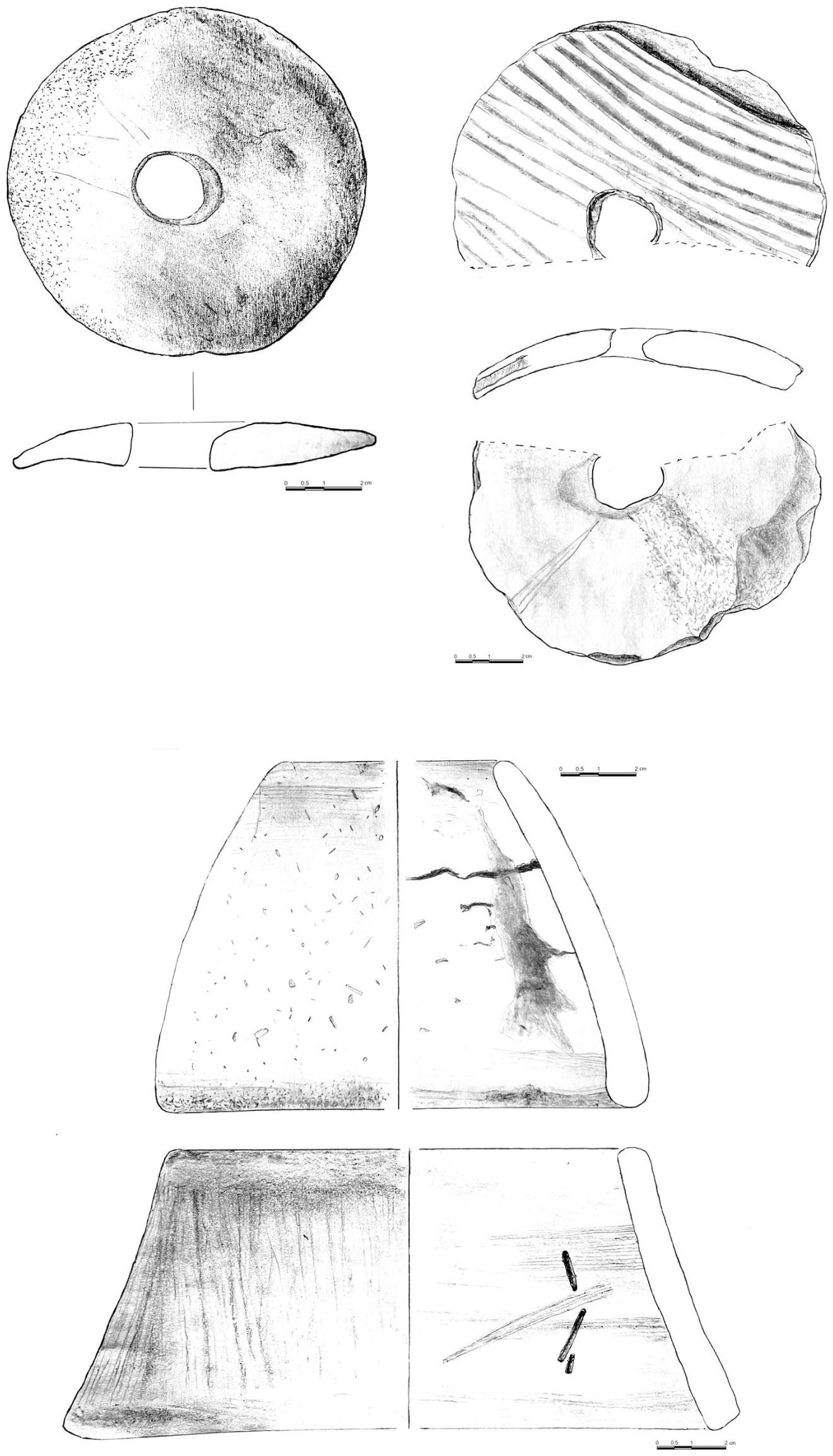
Preliminary drawings of the Clayton rings and discs from Tinidbah Site 2. The disc to the right shows clear reuse of a ceramic fragment to manufacture it (drawings: © CTEDH 2023).
Clayton rings and discs are known as one of the distinguishing features of material culture of the Sheikh Muftah culture in the Western Desert around Dakhla Oasis. 11 However, they have been found in several other locations in the desert, mostly west of the Nile Valley – in one case very close to the Nile Valley at the Theban region. 12 Only a few cases are known where Clayton rings were found in the Eastern Desert of Egypt, in Um Sidrah and Khattarah. 13 Finding Clayton rings in Tinidbah Site 2, not far away from the Theban region and in the zone of its hinterlands, is significant.
Additionally, lithic remains are present in close proximity to the Alam on the summit of the hill. A total of eleven stone lines are observed to run down the northern and western flanks of this knoll, between which there are three Alamat. The eastern flank is bordered by a deeply incised wadi bed, which has resulted in the formation of a small, hollowed-out cliff on this side of the knoll. This still retains some vegetation. To the east of this, at an approximate distance of 140 m and situated on an elevated wadi floor, there are a further nine round stone piles, two of which are associated with lithic remains. Approximately 150 m to the northwest of this prominent knoll, there are a further eleven round stone piles (fig. 13).
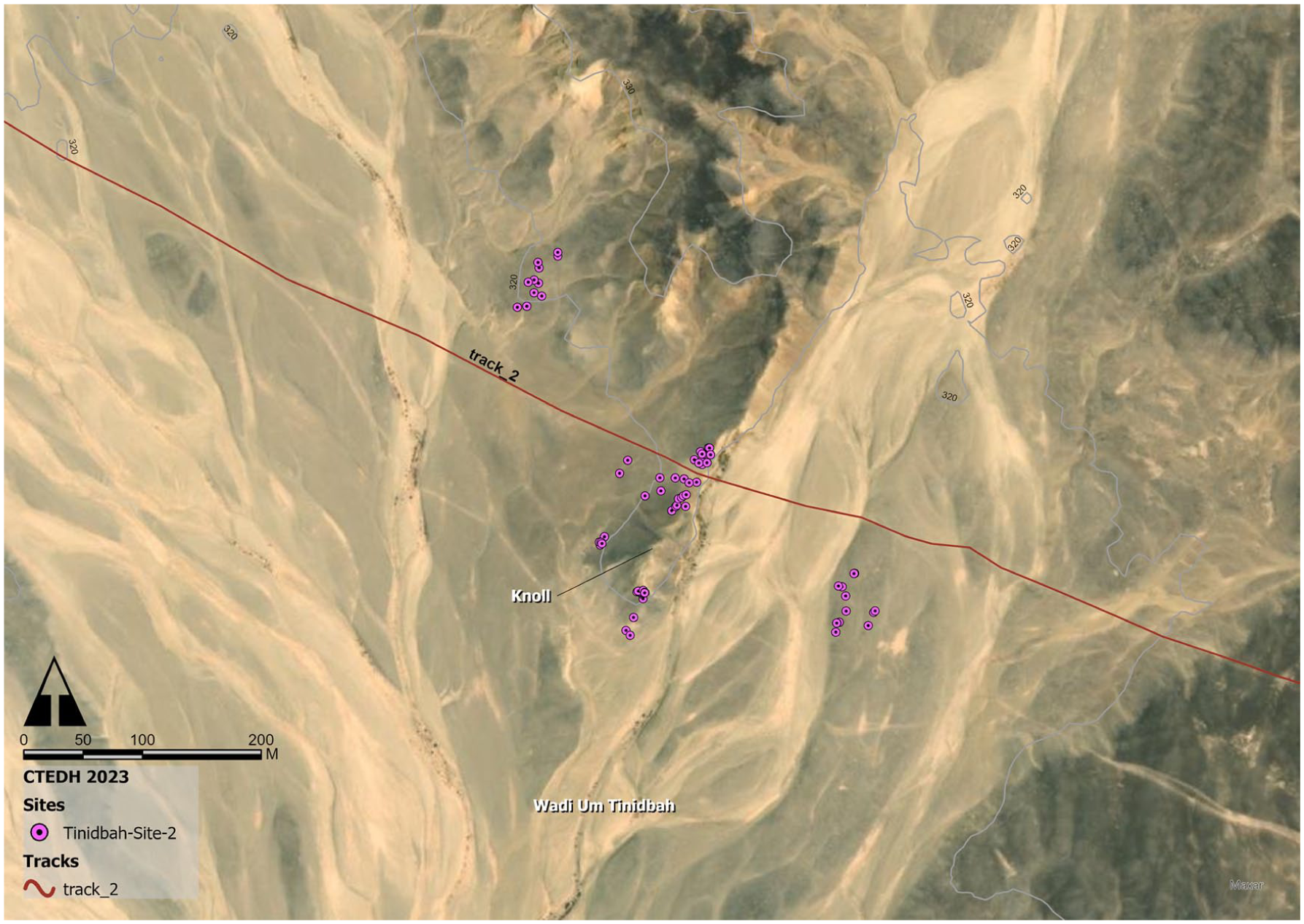
Map of Tinidbah Site 2 with round stone piles and the prominent knoll. Small boxes: Clayton ring discs found near round stone piles at Tinidbah Site 2 (image: © CTEDH 2023).
Tinidbah Site 3
The site comprises a series of disparate features distributed along a 500 m length of a small tributary of Wadi Umm Tinidbah. Three stone lines are situated in close proximity to a rectangular stone feature on the northern slope of the wadi shoulder. To the east of this structure lies another stone line, surrounded by two semi-circular stone structures located in the wadi bed. A little further east of these structures, slightly elevated, are three round stone piles, one of which exhibits indications of an illegal excavation in its central portion. Approximately 200 m to the east lies another round stone pile, situated adjacent to a destroyed, relatively large rectangular stone feature.
Tinidbah Site 4
The site, which encompasses an area of approximately 500 m in width, has yielded evidence of a range of archaeological features. One round stone pile is situated on the elevated bank of a tributary of Wadi Umm Tinidbah. In the immediate vicinity, a rectangular stone structure is also present. To the east of this, four stone lines run down the northern slope of the shoulder of one of the larger wadis of Umm Tinidbah. A Clayton ring disc was discovered at this location. Approximately 80–140 m further along the slope to the south, ceramic remains and two flint tools were identified, with one of the latter probably dating to the Palaeolithic Period. It is unclear whether these findings were in situ at this location or if they are the result of fluvial processes. Another round stone pile is situated in front of these.
Tinidbah Site 5
The site is situated on the southern plateau of Wadi Umm Tinidbah, at an approximate distance of 1.4 km west of Tinidbah Site 2 (fig. 14). A total of 29 round stone piles are distributed across two distinct plateaus. Additionally, one of the stone piles is situated between the two plateaus in the bed of a minor side wadi. The stone circles are filled with medium-sized stones in the centre, creating a complete stone cover. It is suspected that some of the stone piles may have been illegally excavated, as there are sandy patches in their centre and scattered stones around them. Their structure, location, and distribution suggest that these round stone piles may be graves, but further investigation is required to confirm this hypothesis.
Map of Wadi Umm Tinidbah and its sites (image: © CTEDH 2023).
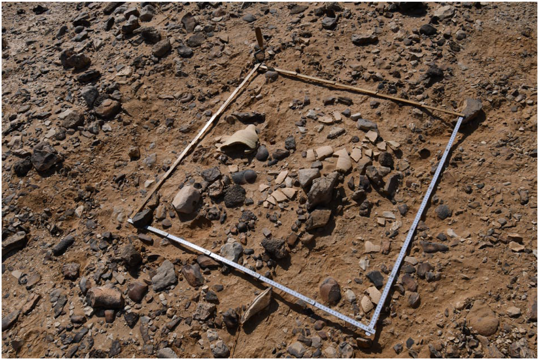
Umm Khiyam Site 1 (fig. 15)
Umm Khiyam Site 1 at Track 3_1_1 (image: © CTEDH 2023).
The site is characterised by the presence of multiple accumulations of pottery, distributed along the ruts and in their immediate vicinity. Some of the ceramic sherds could be reconstructed into vessels with a high degree of completeness. A comprehensive dating of the sherds is still pending, although one fragment of a vessel has been assigned to the Naqada II period thus far. The majority of the remaining sherds appear to date to a later period. In the vicinity of those ceramic accumulations, sites of iron oxide were identified.
Ceramics
A variety of pottery types have been identified in the vicinity of the tracks and in association with specific archaeological sites. In certain instances, it was feasible to partially reconstruct vessels that were largely complete (fig. 16). However, in the case of other individual pieces, it is challenging to obtain further information due to the extent of erosion. Some pieces have so far been roughly dated, including one C-ware vessel, one Naqada II vessel, and parts of early Roman amphorae and late Roman amphorae. Many of the remaining sherds also appear to be of Roman date. Of particular interest is the discovery of parts and three discs from a Clayton ring. It should be noted, however, that this is not the first instance in which Clayton rings have been discovered in the Eastern Desert. The recently discovered fragments are distinguished by their manufacture from Nile clay, with some discs crafted from reused potsherds from the Nile Valley (fig. 12). Another detailed article will be dedicated to the ceramic finds after detailed analysis in the future.
Pottery sherds of an almost complete vessel (photo: © CTEDH 2023).
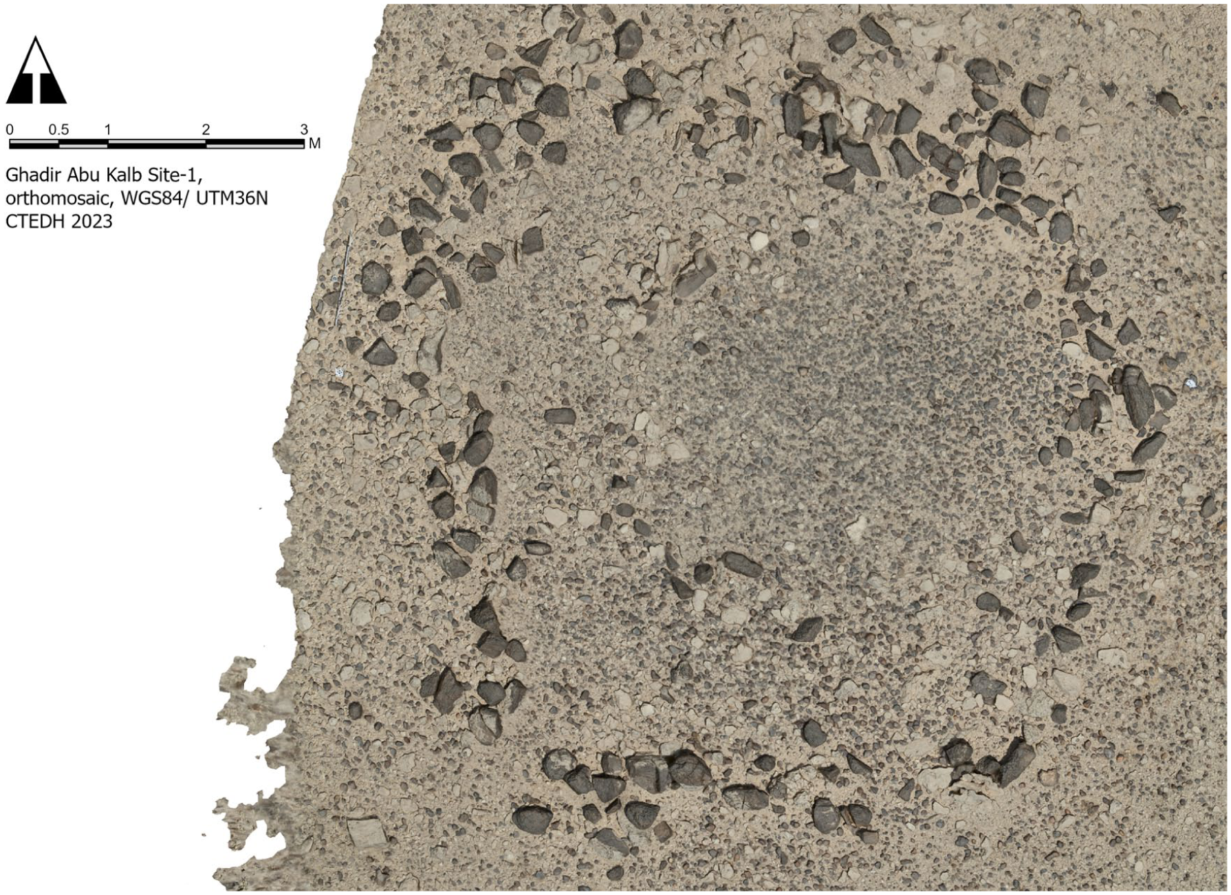
Ghadir Abu Kalb Site 1: stone circle with lithic debitage surrounding it. Small box: lithic tools and core (image: © CTEDH 2023).
Lithics
In addition to the ceramics, lithic tools constituted another source of finds. The shapes of the lithic tools indicate that both Palaeolithic and Neolithic tools can be identified; however, further detailed processing is still pending. Nevertheless, an initial assessment has already permitted the identification of blades bearing traces of use (retouching). Furthermore, the raw material of some of the tools appears to have been sourced from flint mining, rather than from the flint nodules that are distributed throughout the landscape. A particularly high concentration of lithic remains was found at Ghadir Abu Kalb Site 1. Within a radius of a few metres around a rough stone circle were various lithic artefacts, including cores and flakes, which suggest local production. Since Track 1 ends in the wadi before this point, the question arises whether any nearby flint deposits could have served as a destination point. The strong desert varnish coating the majority of the tools and manufacturing remains, in conjunction with no ceramic finds so far, could suggest that this site is of a particularly early age. Further investigation in this area would be beneficial. Further investigations in the future would reveal more.
Alamat
Over 120 of the stone features identified are believed to be examples of what are known as Alamat (cairns), which are piles of stones used until relatively recent times to mark a path. These structures are distinguished from other piles of stones by their simple construction, comprising stones stacked on top of each other, which are typically found in close proximity to or on paths. In some instances, these structures have been identified at elevated locations, presumably to facilitate observation from greater distances. Due to their distinctive design, there is a possibility of confusion with other types of stone piles, such as round stone piles, which cannot be entirely discounted. Nevertheless, in many instances, they can still be identified as signposts in the present day.
Alamat are a prominent material culture that are usually found along the desert routes all over the Sahara. 14 Their size and material differ from one site to another, and depend on who erected these Alamat. Further investigation in future seasons would reveal more about them.
Footnotes
Funding
This campaign was financed by the Gerda Henkel Foundation.
5.
7.
8.
Bubenzer and Bolton 2013: 70–71; ![]() : 19–61.
: 19–61.
13.
Gatto 2012: 61–72; ![]() : 50–60.
: 50–60.
14.
As an example, the Alamat found along Abu Ballas trail. See: Riemer 2013: 77–102.